
Community hub
Recent from talks
Contribute something
Nothing was collected or created yet.
Dharmapuri
View on WikipediaThis article includes a list of general references, but it lacks sufficient corresponding inline citations. (September 2023) |
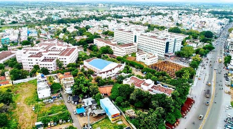
Dharmapuri is a city in the north western part of Tamil Nadu, India. It serves as the administrative headquarters of Dharmapuri district which is the first district created in Tamil Nadu after the independence of India by splitting it from then Salem district on 2 October 1965. The city is located 50 km from Krishnagiri, 69 km from Salem, 60 km from Tirupattur, 90 km from Hosur, 117 km from Thiruvannamalai, 126 km from Bangalore and Erode, 181 km from Tiruppur, 200 km from Coimbatore and Tiruchirappalli, 300 km from Madurai and the state capital Chennai. It is located between latitudes N 11 47’ and 12 33’ and longitudes E 77 02’ and 78 40’. It is one of the major leading cultivators and producers of mangoes in the state along with Krishnagiri, and is often referred as Mango Capital of India.
Key Information


History
[edit]Dharmapuri was called Thagadoor where King Adhiyamaan ruled. Adhiyaman Kottai is situated near Dharmapuri-Salem highway. Many temples were built during Adhiyamaan's rule. There is a tunnel from Adhiyamaan kottai temple to Dharmapuri Kottai temple.
The region is believed to have been controlled by the Pallava dynasty in the 8th century. The Rashtrakutas took over in the 9th century. They were defeated by the Cholas in the 11th century, and subsequently the district came under the Chola sphere of governance.[2]
During 18th century present day Dharmapuri district was part of the Kingdom of Mysore and was called Baramahal. As part of the Treaty of Seringapatam (signed on 18 March 1792) after the Third Anglo-Mysore War, Tipu Sultan agreed to give part of his territories including present-day Dharmapuri district to the British East India Company which was then merged into the Madras Presidency an administrative subdivision of British India.
It was part of the salem District under British rule, until the founding of Dharmapuri district on 2 October 1965. The Dharmapuri district was split into Dharmapuri and Krishnagiri districts in 2004.[2] Many historical rock sculptures are found in this district. Modhur, a village near Dharmapuri has remains that date back to the Neolithic age. A government museum in Dharmapuri city displays some of these significant sculptures.
Dharmapuri Municipality
[edit]February 14, 1964 Third Grade Municipality,
August 5, 1971 Second Grade Municipality,
August 31, 1987 First Grade Municipality,
December 2, 2008 Selection Grade Municipality,
March 6, 2019 Special Grade Municipality.
The Dharmapuri Municipality has 33 wards. The Tamil Nadu government has changed the name of Special Grade Municipalities to "Perunagaratchigal" in Tamil, but they are still called "Special Grade Municipalities" in English.
Geography
[edit]Dharmapuri is situated in the northwestern corner of Tamil Nadu and is bounded by the Eastern Ghats to the east, Nallampalli taluk to the South, Palacode taluk to the north, and the Pennagaram taluk to the west. It is located between latitudes N 11 47’ and 12 33’ and longitudes E 77 02’ and 78 40’. It is 300 km from Chennai city and 130 km from Bangalore. All the corporations in Tamil Nadu except Sivakasi, Nagercoil, Thoothukudi and Tirunelveli lies within 300 km from Dharmapuri. Cities from neighboring states like Bangalore, Mysore, Tumkur, Chittoor, Tirupathi, Thrissur, Palakkad, Salem, Puducherry also lie within a 300 km radius. Dharmapuri is located on a geographically important area in South India.[1]
Climate
[edit]Dharmapuri has a tropical wet and dry climate (Köppen Aw). The summer period of March, April, May, and June is sweltering and dry, reaching a maximum temperature of up to 38 °C or 100.4 °F. The temperatures drop in December and the low temperatures continue up to February, touching a minimum of 14 °C or 57.2 °F in January. The district has an average annual rainfall of 910 millimetres or 35.83 inches. The tropical forests here generally have short shrubs and thorned plants.[2]
| Climate data for Dharmapuri (1991–2020, extremes 1975–2020) | |||||||||||||
|---|---|---|---|---|---|---|---|---|---|---|---|---|---|
| Month | Jan | Feb | Mar | Apr | May | Jun | Jul | Aug | Sep | Oct | Nov | Dec | Year |
| Record high °C (°F) | 34.7 (94.5) |
38.5 (101.3) |
40.2 (104.4) |
41.0 (105.8) |
41.4 (106.5) |
40.0 (104.0) |
41.0 (105.8) |
38.0 (100.4) |
37.6 (99.7) |
35.5 (95.9) |
33.8 (92.8) |
33.8 (92.8) |
41.4 (106.5) |
| Mean daily maximum °C (°F) | 29.7 (85.5) |
32.7 (90.9) |
35.8 (96.4) |
36.8 (98.2) |
36.5 (97.7) |
34.2 (93.6) |
33.2 (91.8) |
32.5 (90.5) |
32.3 (90.1) |
30.7 (87.3) |
29.0 (84.2) |
27.9 (82.2) |
32.7 (90.9) |
| Mean daily minimum °C (°F) | 17.7 (63.9) |
18.9 (66.0) |
20.8 (69.4) |
23.8 (74.8) |
24.5 (76.1) |
23.9 (75.0) |
23.4 (74.1) |
23.1 (73.6) |
22.6 (72.7) |
21.9 (71.4) |
20.4 (68.7) |
18.3 (64.9) |
21.6 (70.9) |
| Record low °C (°F) | 10.6 (51.1) |
11.0 (51.8) |
14.2 (57.6) |
17.0 (62.6) |
18.2 (64.8) |
19.4 (66.9) |
18.9 (66.0) |
15.5 (59.9) |
17.7 (63.9) |
12.9 (55.2) |
13.0 (55.4) |
10.9 (51.6) |
10.6 (51.1) |
| Average rainfall mm (inches) | 2.6 (0.10) |
2.3 (0.09) |
16.4 (0.65) |
52.9 (2.08) |
120.3 (4.74) |
71.8 (2.83) |
73.9 (2.91) |
113.9 (4.48) |
143.5 (5.65) |
193.2 (7.61) |
110.9 (4.37) |
40.3 (1.59) |
942 (37.1) |
| Average rainy days | 0.3 | 0.2 | 0.9 | 2.8 | 6.6 | 3.9 | 4.1 | 6.2 | 7.0 | 9.7 | 6.5 | 2.7 | 50.8 |
| Average relative humidity (%) (at 17:30 IST) | 50 | 41 | 33 | 38 | 48 | 52 | 56 | 58 | 61 | 71 | 69 | 62 | 53 |
| Source: India Meteorological Department[3][4][5] | |||||||||||||
Demographics
[edit]| Year | Pop. | ±% |
|---|---|---|
| 1941 | 11,678 | — |
| 1951 | 24,094 | +106.3% |
| 1961 | — | |
| 1971 | — | |
| 1981 | — | |
| 1991 | 59,318 | — |
| 2001 | 64,496 | +8.7% |
| 2011 | 68,619 | +6.4% |
| 2017 | 113,218 | +65.0% |
| Sources: | ||
According to the 2017 census, Dharmapuri had a population of 113,218 with a sex-ratio of 1,013 females for every 1,000 males, much above the national average of 929.[6] A total of 6,759 were under the age of six, constituting 3,470 males and 3,289 females. Scheduled Castes and Scheduled Tribes accounted for 6.92% and 0.14% of the population respectively. The average literacy of the town was 77.08%, compared to the national average of 72.99%.[6] The town had a total of 17,136 households. There were a total of 26,943 workers, comprising 606 cultivators, 427 main agricultural laborers, 1,052 in household industries, 22,566 other workers, 2,292 marginal workers, 54 marginal cultivators, 77 marginal agricultural laborers, 213 marginal workers in household industries and 1,948 other marginal workers.[7]
As per the religious census of 2011, Dharmapuri (M) had 88.99% Hindus, 9.65% Muslims, 0.99% Christians, 0.02% Sikhs, 0.01% Buddhists, 0.01% Jains and 0.33% following other religions.[8]
Politics
[edit]It is part of the Dharmapuri (state assembly constituency) and Dharmapuri (Lok Sabha constituency). The Member of Lok Sabha is Thiru.Mani (Dharmapuri).
Transport
[edit]Roadways
[edit]Dharmapuri is well connected by major National highway NH-44. Commonly called north–south corridor which originates from Srinagar and terminates at Kanyakumari passes through the district. Another highway it encompasses is NH-844 which originates from Adhiyamankottai in Dharmapuri and terminates at Neraluru village near Chandrapura, Bengaluru. State highways like SH-60 (Hogenakkal-Pennagaram-Dharmapuri-Tirupattur), & SH-60A(Dharmapuri-Harur) via Morappur also passes through the city. The Dharmapuri-Harur section and Thanipadi-Thiruvannamalai section of SH-60A is currently being widened to four lane roads providing an alternative route to major cities like Puducherry and Villupuram via Thiruvannamalai from Dharmapuri.
Local and long-distance buses stop there. Tamil Nadu State Road Transport Corporation, Karnataka, Kerala and Andhra Pradesh State Transport Corporation buses operate there.
Railways
[edit]Dharmapuri railway station (DPJ) is situated 1.6 kilometer from Dharmapuri bus stand. The station was fractured to South Western Railways when they reformed it. Now it is under the Bangalore railway division. The railway station currently has one functional line, the Bengaluru–Dharmapuri–Salem line. The other line, Dharmapuri–Morappur line, which was constructed in 1907 functioned for about 38 years and was removed by the Indian government. However again the line is under construction with electrification due to the necessity of the people in the district. This new line will connect the people of Dharmapuri district to Chennai directly. As well as this line is the alternative route for Bangalore–Chennai (via Dharmapuri). Dharmapuri has two more important railway stations viz. Morappur (MAP) and Bommidi (BQI) which comes under Southern Railway Salem Division. These stations connects Chennai and Coimbatore through Katpadi, Jolarpettai, Salem, Erode Junctions,
Airways
[edit]The nearest airport, Salem airport, is located in Salem at a distance of 45 kilometres (28 mi) and nearest International airport is Kempegowda International Airport, located in Devanahalli, near Bengaluru (Bangalore), at a distance of 155 kilometres (96 mi).
Notable people
[edit]- K. P. Anbalagan Politician
- R. Senthil Politician
- S. Senthilkumar (politician)
- Udaykumar Indian actor and producer
References
[edit]- ^ "Dharmapuri District, Government of Tamil Nadu | Land of Adhiyaman Fort | India". Retrieved 25 August 2020.
- ^ "RMC WELCOME TO THE WORLD OF METEOROLOGY". tamilnadutourism.org. Retrieved 25 August 2020.
- ^ "Climatological Tables of Observatories in India 1991-2020" (PDF). India Meteorological Department. Retrieved 8 April 2024.
- ^ "Station: Dharmapuri Climatological Table 1981–2010" (PDF). Climatological Normals 1981–2010. India Meteorological Department. January 2015. pp. 241–242. Archived from the original (PDF) on 5 February 2020. Retrieved 15 March 2020.
- ^ "Extremes of Temperature & Rainfall for Indian Stations (Up to 2012)" (PDF). India Meteorological Department. December 2016. p. M194. Archived from the original (PDF) on 5 February 2020. Retrieved 15 March 2020.
- ^ a b "Census Info 2011 Final population totals". Office of The Registrar General and Census Commissioner, Ministry of Home Affairs, Government of India. 2013. Retrieved 26 January 2014.
- ^ "Census Info 2011 Final population totals - Dharmapuri". Office of The Registrar General and Census Commissioner, Ministry of Home Affairs, Government of India. 2013. Archived from the original on 24 September 2015. Retrieved 26 January 2014.
- ^ "Population By Religious Community - Tamil Nadu" (XLS). Office of The Registrar General and Census Commissioner, Ministry of Home Affairs, Government of India. 2011. Retrieved 13 September 2015.
See also
[edit]| Taluks |  | |
|---|---|---|
| Blocks | ||
| Municipality | ||
| Town panchayats | ||
| Cities and towns |
| |
| Villages |
| |
| Revenue divisions | ||
Dharmapuri
View on GrokipediaDharmapuri is a district in northwestern Tamil Nadu, India, spanning 4,497 square kilometers and headquartered in the city of Dharmapuri, which serves as the administrative center for the region.[1][2] The district's terrain consists of upland plateaus with hill ranges and undulating plains, bordered by neighboring districts and featuring the Kaveri River in parts of its landscape.[3] Its climate is predominantly hot and dry during summers, supporting an agrarian economy where agriculture and allied sectors engage about 70 percent of the population, focusing on crops such as paddy, millets, pulses, sugarcane, and mangoes.[2][4] As of the 2011 census, the population stood at 1,506,843, reflecting a rural-dominated demographic with significant reliance on farming for livelihood.[1] Historically, the area was known as Tagadur during the Sangam era, ruled by chieftains including Adigaman Naduman Anji, whose patronage supported the poetess Avvaiyar and marked early cultural prominence.[5] Subsequent governance included influences from dynasties such as the Pallavas, Rashtrakutas, and Cholas, embedding the district with ancient temples and memorials like Adhiyaman Kottam, dedicated to its early rulers.[6] Notable natural and cultural sites include the Hogenakkal Falls on the Kaveri River, renowned for its scenic and medicinal properties, and sacred locations such as Theerthamalai Temple, which draw visitors for their historical and religious value.[7] These features underscore Dharmapuri's role as a blend of agricultural heartland and heritage site in Tamil Nadu.[8]
History
Ancient and Sangam Period
Archaeological surveys in Dharmapuri district have identified numerous megalithic structures, including cairn circles, dolmens, and stone alignments, associated with the Iron Age culture dating from approximately 1200 BCE to 300 BCE.[9][10] These sites, concentrated in areas like Pennagaram taluk and near villages such as Thoppur and Ajjipatti, contain artifacts like iron tools, earthen pots, and grindstones, pointing to settled communities practicing agriculture and burial rituals with superstructures over cists.[11][12] The prevalence of such monuments reflects the region's suitability for early ironworking and resource exploitation, with the hilly topography providing natural defenses and access to riverine soils for millet and pulse cultivation. In the Sangam period (c. 300 BCE–300 CE), Dharmapuri was known as Tagadur (or Thagadur), functioning as a key settlement and capital of the Adiyaman velir chieftains, who governed the Mazhanadu region encompassing parts of modern Dharmapuri and Salem.[5] The most prominent ruler, Adigaman Neduman Anji, is documented in Sangam texts for his patronage of literature, notably sustaining the poetess Avvaiyar and gifting her a rare gooseberry fruit in recognition of her wisdom.[5][13] Tagadur's strategic position amid ghats and trade routes fostered economic activity in grains, salt, and forest products, as alluded in poems emphasizing its prosperity and martial ethos. Sangam literature, including Purananuru and Akananuru, references Tagadur as a hub of heroic deeds and alliances, with hero stones (virikkals) inscribed nearby commemorating fallen warriors from cattle raids and inter-clan conflicts, a practice rooted in Iron Age traditions.[13] The Adiyamans maintained semi-independent status amid interactions with the Chera kingdom, leveraging the area's terrain for defense while contributing to broader Tamil cultural exchanges, though primary reliance on oral and poetic sources limits precise chronologies.[14]Medieval Dynasties and Regional Powers
During the 8th century, the northern regions encompassing Dharmapuri fell under Pallava control, as indicated by archaeological finds such as hero stones from the dynasty unearthed in tribal areas like Vathalmalai.[15] These memorials, often depicting warriors in combat, reflect the martial ethos and local chieftain loyalties amid Pallava expansion into Tondaimandalam and adjacent territories. By the early 9th century, Rashtrakuta power supplanted Pallava influence in Dharmapuri, shaping district history for approximately two centuries through military campaigns and administrative oversight.[5] Nolamba chieftains, operating as feudatories in the borderlands, erected hero stones commemorating battles, such as one from Kottarapatti village near Harur taluk, underscoring localized conflicts over land and cattle raids during this transitional phase. Chola expansion into Kongunadu, which included Dharmapuri, occurred under Aditya I's conquest in 894 CE, integrating the region into the imperial domain and displacing prior rulers.[16] Inscriptions and hero stones from the Chola era, including those referencing Rajendra II, document ongoing skirmishes, such as defeats around 949–950 CE, highlighting persistent resistance from local warriors and the role of nadu-level assemblies in land governance. These artifacts reveal a warrior culture where chieftains protected communal resources, with memorials serving as evidence of feudal obligations and territorial control.[17] Following Chola decline in the 13th century, Hoysala incursions disrupted control before Vijayanagara campaigns in the 14th century extended authority over Dharmapuri, maintaining dominance until the empire's fall in 1565 CE.[5] Under Vijayanagara and its Nayak viceroys, the period saw fortified hill settlements and temple endowments, fostering agricultural stability through irrigation enhancements and patronage of Shaivite shrines, as inferred from regional architectural continuity.[5] This era's inscriptions emphasize administrative decentralization via amaram land grants to military elites, promoting economic resilience amid power shifts.[16]Colonial Period and British Administration
Following the Fourth Anglo-Mysore War, which concluded in 1799 with the defeat and death of Tipu Sultan, British forces recaptured several territories in the Hosur taluk area of what is now Dharmapuri district, including Nilgiri, Anjetti, Durgam, Ratnagiri, and Kelamangalam, integrating them into British-administered domains under the East India Company.[5] These acquisitions expanded British influence in the Salem region, previously contested during earlier Anglo-Mysore conflicts, such as the 1768 siege of Dharmapuri fort where British victory highlighted the challenges of territorial consolidation amid local resistance.[18] Under the Madras Presidency, Dharmapuri functioned as a taluk within Salem District from the early 19th century until Indian independence in 1947, subject to centralized British revenue administration dominated by the ryotwari system.[5] This direct settlement with individual ryots (cultivators) replaced intermediary zamindars in much of the presidency, setting land revenue assessments based on soil productivity and crop yields, with demands fixed for 30-year periods to ensure predictable extraction—typically 45-55% of net produce in ryotwari areas like Salem.[19] However, the system's rigidity, prioritizing revenue stability over agrarian flexibility, often led to over-assessment and indebtedness among ryots during variable monsoons, as periodic resettlements failed to fully account for declining soil fertility or market fluctuations without intermediary buffers.[20] The region experienced recurrent famines characteristic of the Madras Presidency's drier tracts, with Salem classified as a famine-prone district; early 19th-century scarcities from 1800-1860 affected local agriculture, while the Great Famine of 1876-78 caused significant distress despite relatively lower mortality than in districts like Bellary or Kurnool, attributable to partial relief measures amid revenue arrears exceeding 20% in affected taluks.[21] British responses emphasized grain imports and work relief but were critiqued for inadequacy, as fixed revenue demands persisted even in shortfall years, straining peasant resilience without systemic irrigation expansions.[22] Infrastructure developments were limited but included ghat roads linking Dharmapuri to Salem for administrative access and troop movement, predating rail extensions in the late 19th century, though these primarily served revenue collection over local economic integration.[23] Population data from presidency-wide censuses indicate stagnation or slight declines in Salem taluks during famine peaks, with ryotwari enforcement displacing marginal cultivators to non-assessed wastelands, reflecting extractive priorities over demographic stability.[24]Post-Independence Formation and Developments
Dharmapuri District was formed on 2 October 1965 through the bifurcation of Hosur, Krishnagiri, Dharmapuri, and Harur taluks from Salem District, establishing it as the first new district in the Madras State (later Tamil Nadu) after India's independence.[1][25] This administrative division addressed regional governance needs in a predominantly agricultural area, with Dharmapuri town designated as the headquarters.[1] The region, previously integrated into the Madras State following the linguistic boundaries set by the States Reorganisation Act of 1956, experienced continued administrative stability without territorial loss, as its Tamil-speaking core remained intact amid broader state adjustments.[1] During the 1970s and 1980s, state-led infrastructure initiatives emphasized rural connectivity and irrigation enhancements, such as minor irrigation tanks and road networks, to bolster agricultural productivity in this drought-prone zone.[25] A significant reconfiguration occurred on 9 February 2004, when northern taluks including Krishnagiri and Hosur were separated to form the new Krishnagiri District, reducing Dharmapuri's area and focusing its administration on core southern territories.[26][27] Concurrently, educational outreach programs contributed to literacy gains, with the district's rate rising from 60.31% in the 2001 census to 68.54% in 2011, though it remained among Tamil Nadu's lower performers, particularly in rural female literacy at 59.8%.[28][29] The Hogenakkal Integrated Drinking Water Project, launched in the early 2000s to combat fluorosis and supply potable water via the Cauvery River, marked a key resource development for the district, targeting coverage for over 800,000 residents through desalination and distribution infrastructure despite implementation delays.[30][31] Agricultural modernization efforts in the same period included promotion of high-yield crop varieties and micro-irrigation under state schemes, aiming to mitigate reliance on rain-fed farming in this semi-arid landscape.[30]Geography
Location and Topography
Dharmapuri district occupies the northwestern portion of Tamil Nadu, India, spanning latitudes between approximately 11°47' N and 12°33' N and longitudes 77°02' E and 78°40' E. Its central coordinates are roughly 12.1° N, 78.1° E. The district borders Salem district to the south, Krishnagiri district to the west, and Karnataka state to the north, with eastern boundaries adjoining parts of Salem and Vellore districts.[32][33][34] The total geographical area of the district measures 4,497 square kilometers. Elevations vary from around 400 meters in the plains to over 600 meters in hilly sections, with an average of approximately 460 meters. The topography consists of undulating terrain featuring low hills and plateaus in the northern and western regions, transitioning to flatter valleys and plains in the south suitable for cultivation.[1][35][36] Geologically dominated by Archaean crystalline rocks, the district's rolling landscape and steep slopes in upland areas contribute to erosion-prone red and lateritic soils, as evidenced by morphometric analyses indicating moderate drainage density and rugged relief that accelerate surface runoff and soil loss.[3][37][38]