
Community hub
0 subscribers7 pages, 0 posts
Recent from talks
All channels
Be the first to start a discussion here.
Be the first to start a discussion here.
Be the first to start a discussion here.
Be the first to start a discussion here.
Contribute something
Welcome to the community hub built to collect knowledge and have discussions related to Timeline of first images of Earth from space.
Nothing was collected or created yet.
Timeline of first images of Earth from space
View on Wikipediafrom Wikipedia
Photography and other imagery of planet Earth from outer space[a] started in the 1940s, first from rockets in suborbital flight, subsequently from satellites around Earth, and then from spacecraft beyond Earth's orbit.
Timeline
[edit]| Image | Date | Craft or mission | Event | ||||
|---|---|---|---|---|---|---|---|

|
October 24, 1946 | V-2 | First images of Earth from outer space,[1][2][3][4][5][6][7][8] flight monitoring continuous imaging, resulting in a timelapse-movie reel. Not published as Earth observation images until 1950.[9] Taken by the V-2 No. 13 suborbital spaceflight, the eighth successful US spaceflight and one of the first over-all. | ||||

|
March 7, 1947 | First dedicated and first published Earth observation images from outer space, first published on March 25, 1947.[9][10][11][12] | |||||

|
July 26, 1948 | First prepared wide-angle panorama of Earth from outer space (the 1946 flight did already record a panorama swing).[citation needed] | |||||

|
October 5, 1954 | Aerobee AJ10-24
RTV-N-10b |
The first color image from space as part in the left corner of this first color photomosaic of Earth from space,[13] composed of 117 images taken from an altitude of 100 miles (160 km).[14][15] | ||||
| [image needed] | February–March 1959 | Vanguard 2 | First attempt of a scanner, in which a single photocell mounted at the focus of telescope would scan Earth due to the satellite movement; resulting images were poor.[16] | ||||

|
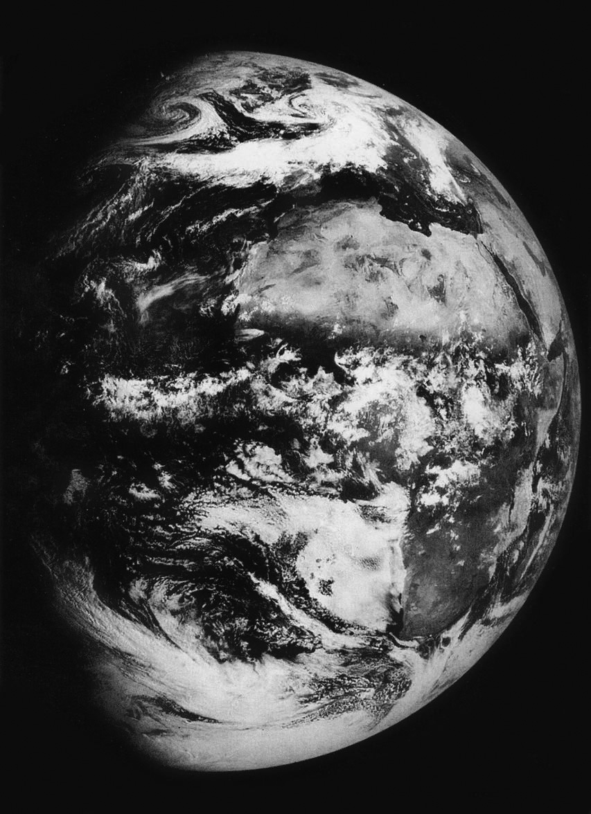
August 14, 1959 | Explorer 6 | First image of Earth from orbit, showing a sunlit area of the Central Pacific Ocean and its cloud cover.[17][18][19][20] | ||||
| [image needed] | 1959 | Explorer 7 | The first "coarse maps of the solar radiation reflected by the Earth and the infrared radiation emitted by the Earth", from a mission launched on October 13, 1959.[21] | ||||

|
1960 | TIROS-1 | First television image of Earth from space and first weather satellite picture.[22] | ||||

|
August 18, 1960 | CORONA | "First space-based Earth observation system";[23] its first successful mission was Discoverer 14 on 19 August 1960 with the recovery of photographic film from an orbiting satellite.[23][24] | ||||
|
August 6, 1961 | Vostok 2 | First image, color images and movie of Earth from space taken by a person, by cosmonaut Gherman Titov – the first photographer from space.[25][26] | ||||

|
1963 | KH-7 Gambit | First high-resolution (sub-meter spatial resolution) satellite photography (classified).[27] | ||||

|
1964 | Quill | First radar images of Earth from space, using a synthetic aperture radar (SAR).[28] This shows part of Richmond, Virginia. | ||||

|
March 18, 1965 | Voskhod 2 | First image and movie of Earth with a human (Alexei Leonov) floating in space (the first ever EVA).[29] | ||||
|
March 18, 1965 | Voskhod 2 | First drawing of Earth from space and art made in space (by Leonov, the first artist in space).[30] | ||||
|
May 30, 1966 | Molniya 1–3 | First full-disk pictures of the Earth, published in Review of Popular Astronomy July–August.[31][20] | ||||

|
August 23, 1966 | Lunar Orbiter 1 | First image of Earth from another astronomical object (the Moon) and first picture of both Earth and the Moon from space.[32][33][34][7][19] The image (frame 1102; image 102 of Lunar Orbiter 1) consists of three parts h1-h3.[35] Since its original publication its raw analog data has been used to digitally produce the image (including its wide angle version) in higher resolution (see) and clarity (see).[36] | ||||

|
December 11, 1966 | ATS-1 | First picture of both Earth and the Moon from the Earth's orbit.[37] | ||||
,_1966.jpg)
|
First full-disk pictures of the Earth from a geostationary orbit.[37] | ||||||
| [image needed] | January 1967 | First movie of Earth from space made without a human camera operator (contrast to Titov's 1961 movie).[37] | |||||

|
April 24, 1967[38] | Surveyor 3 | First images showing both sunset and sunrise over Earth at the same time, taken from the Moon's surface during a solar eclipse caused by Earth (rather than the Moon).[39][40] | ||||

|
April 30, 1967 | First color image of Earth from the surface of another astronomical object, from the Moon's surface.[41] | |||||
.png)
|
September 20, 1967 (released November 10th)[42] | DODGE | First full-disk black-and-white filtered[42] color picture of the Earth.[6] | ||||

|
November 10, 1967 | ATS-3 | First full-disk "true color"[43] picture of the Earth;[44] subsequently used on the cover of the first Whole Earth Catalog.[45][44] | ||||
|
September 14, 1968 | Zond-5 | Black-and-white image of a half-disk of the Earth with Africa and Arabian Peninsula clearly visible.[46][47] The images were taken approximately 90,000 km away from Earth. They were taken on the film camera with 400mm focal length. | ||||

|
December 21, 1968 (December solstice) | Apollo 8 | First full-disk image of Earth from space taken by a person (astronaut William Anders).[48] | ||||

|
December 24, 1968 | The first photograph of Earth taken by a person (William Anders)[49] from another astronomical object (the Moon).[50][51] For a colorized version see this image. | |||||

|
The Earthrise image is the first color image of Earth by a person (William Anders) from the moon,[33][6][19] moments after his black-and-white photograph. | ||||||

|
July 21, 1969 | Apollo 11 | The much reproduced full frame image AS11-40-5903 of Buzz Aldrin; happens to be the first indirect image of Earth taken by a person from the surface of another astronomical object (from the Moon), having by accident in his visor a reflection of Earth.[52] | ||||
.jpg)
|
First direct image of Earth taken by a person from the surface of another astronomical object (from the Moon), (AS11-40-5923).[20][53] | ||||||

|
November 24, 1969 | Apollo 12 | First images (black-and-white and 16mm color film) of a solar eclipse with the Earth, taken by a human, when the Apollo 12 spacecraft aligned its view of the Sun with the Earth.[54][55] | ||||
.jpg)
|
December 7, 1972 | Apollo 17 | First fully illuminated color image of the Earth by a person (AS17-148-22725).[56] This photo was taken just before another picture was taken with the same perspective, which cropped and processed became the widely used Blue Marble picture (AS17-148-22727).[57][58] | ||||

|
July–September 1973 | Skylab 3 | Early color image of an aurora by a human from space.[59][60] | ||||

|
November 1973 (components) / 1999 (composition) | Mariner 10 | Mariner took the first high resolution digital color images of Earth from heliocentric orbit in interplanetary space at 2.6 million kilometers, as in this mosaic and composite size comparison image of Earth and the Moon produced in 1999 with images from Mariner 10.[61] | ||||
| [image needed] | 1977 | KH-11 | First real-time satellite imagery.[62] | ||||

|
September 18, 1977 | Voyager 1 | First full-disk picture and first single frame picture of Earth and the Moon together.[37] | ||||

|
February 14, 1990 | The Pale Blue Dot is the first image of Earth from beyond all of the other Solar System planets. It is part of the first picture of the full extent of the planetary system, known as the Family Portrait.[19][63] | |||||
 |
December 11, 1990 | Galileo | First interplanetary fly-by image of Earth during the second ever Earth fly-by,[64] which is also the first frame of the first movie of a full rotation of Earth.[65] | ||||
|
October 13, 1999 | IKONOS | First commercial high-resolution (sub-meter) satellite photography (non-classified); it made the cover of The New York Times.[66] | ||||

|
May 8, 2003 13:00 UTC | Mars Global Surveyor | First image of Earth (and the Moon) from another planet (in orbit around Mars);[67] notice South America is visible.[33][6] | ||||

|
March 11, 2004 | Spirit Mars Exploration rover | First image taken of Earth from the surface of Mars and any celestial body other than the Moon. | ||||

|
July 27, 2006 | Cassini–Huygens | The Pale Blue Orb is the first image of Earth from Saturn.[68] | ||||
 |
August 9, 2021 | Parker Solar Probe | Image and video of Earth from within the outer solar corona, taken during the second time that any probe has ever reached the corona.[69] | ||||

|
September 5, 2024 | Curiosity | First image of Earth with Phobos (from the surface of Mars).[70] | ||||
![[1]](http://public.media.smithsonianmag.com/legacy_blog/Titov-photo.jpg)
![[2]](https://i.guim.co.uk/img/media/108744bd68ec410c50cc21b32f40ed95503e8174/0_0_5520_3313/master/5520.jpg?width=620&quality=45&auto=format&fit=max&dpr=2&s=3502b1f27e3e73d6930c8c9afd1a05a3)
![[3]](https://web.archive.org/web/20211230105242/https://www.nasa.gov/sites/default/files/styles/full_width/public/thumbnails/image/earth_from_molniya_1_may_30_1966_reddit.jpg?itok=XrClNmUo)
.png)
![[4]](https://web.archive.org/web/20210327171332/https://microsites.maxar.com/ikonos20/ikonos20/img/ca0b133.jpg)
See also
[edit]- List of notable images of Earth from space
- Aerial photography – Taking images of the ground from the air
- Earth observation – Information about the Earth environment
- Earth in culture – Cultural perspectives about Earth
- Earth phase – Phases of Earth as seen from the Moon
- Extraterrestrial sky – Extraterrestrial view of outer space
- Overview effect – Cognitive shift after seeing Earth from space
- Satellite imagery – Images taken from an artificial satellite
- Space selfie – Self-portrait photo taken in outer space
- View of Earth from Mars – Extraterrestrial view of outer space
Notes
[edit]- ^ Within the context of this timeline, outer space is considered as starting at the Kármán line, 100 kilometres (62 miles) above mean sea level (AMSL).
References
[edit]- ^ "First Photo From Space". October 24, 2006. Archived from the original on January 29, 2021.
- ^ "The First Image of Earth Taken From Space (It's Not What You Think)". The Atlantic. August 6, 2012. Archived from the original on August 8, 2020.
- ^ "First photo of Earth from space was from deadly rocket". February 26, 2015. Archived from the original on November 8, 2020.
- ^ "70 years ago the first image of Earth was taken from space". October 26, 2016. Archived from the original on October 29, 2016.
- ^ "The First Photo of Earth From Space Was Taken 70 Years Ago Today". October 24, 2016. Archived from the original on October 27, 2016.
- ^ a b c d "Viewing The Earth From Space Celebrates 70 Years". Forbes. August 22, 2016. Archived from the original on August 23, 2016.
- ^ a b "Space Photos Before NASA: The Oldest Images Of Earth". International Business Times. October 28, 2017. Archived from the original on October 28, 2017.
- ^ "The first photograph of Earth taken from space". October 24, 2017. Archived from the original on June 17, 2018.
- ^ a b "T. A. Bergstrahl Publishes the First Book of Photographs of the Earth Taken From Space : History of Information". History of Information. November 19, 2020. Archived from the original on March 12, 2023. Retrieved March 12, 2023.
- ^ "The first photograph from 100 miles out in space, March 7, 1947, Camera on V2 rocket". Christies.com. March 7, 1947. Archived from the original on March 12, 2023. Retrieved March 12, 2023.
- ^ "NASA Electronics Pioneer Dies at 85". NASA. November 4, 2003. Archived from the original on March 12, 2023. Retrieved March 12, 2023.
- ^ "First Pictures of Earth From 100 Miles in Space, 1947". March 6, 2009. Archived from the original on March 7, 2009.
- ^ Theoret, Jeremy (February 6, 2023). "First Color Photo of Earth From Space – The Berg Film I". Apollospace. Archived from the original on March 12, 2023. Retrieved March 12, 2023.
- ^ "Photo-Mosaic, Aerobee | National Air and Space Museum". airandspace.si.edu. Archived from the original on January 7, 2023. Retrieved January 7, 2023.
- ^ "541005-N-NO204-0001". www.nrl.navy.mil. Archived from the original on January 7, 2023. Retrieved January 7, 2023.
- ^ "Vanguard II Turns 60". April 23, 2019. Archived from the original on March 18, 2021. Retrieved March 27, 2021.
- ^ "Explorer 6: 60 years since first Earth photo from space". August 7, 2019. Archived from the original on August 8, 2019.
- ^ "60 years ago first satellite image of Earth". September 7, 2019. Archived from the original on September 7, 2020.
- ^ a b c d "60 Years Ago We Saw Earth From Space for the First Time — Here's How We See It Now". August 22, 2019. Archived from the original on August 23, 2019.
- ^ a b c Mars, Kelli (December 17, 2020). "90 Years of Our Changing Views of Earth". NASA. Archived from the original on March 10, 2022. Retrieved May 21, 2021.
- ^ Kidder, S.Q.; Vonder Haar, T.H. (1995). Satellite Meteorology: An Introduction. Elsevier Science. p. 2. ISBN 978-0-08-057200-0. Archived from the original on March 15, 2024. Retrieved October 5, 2020.
- ^ Anderson, George D. (April 1, 2010). "The first weather satellite picture". Weather. 65 (4): 87. Bibcode:2010Wthr...65...87A. doi:10.1002/wea.550. ISSN 1477-8696.
- ^ a b "2005 Draper Prize – Corona Historic Images". NAE Website. Archived from the original on February 22, 2022. Retrieved October 12, 2020.
- ^ "Discoverer 14 – NSSDC ID: 1960-010A". NASA. Archived from the original on June 11, 2020. Retrieved October 5, 2020.
- ^ Reichhardt, Tony (August 5, 2011). "The First Photographer in Space". Air & Space Magazine. Archived from the original on May 12, 2021. Retrieved May 19, 2021.
- ^ "Vostok-2 mission". RussianSpaceWeb.com. August 6, 1961. Archived from the original on June 15, 2022. Retrieved October 21, 2021.
- ^ "USGS EROS Archive – Declassified Data – Declassified Satellite Imagery – 2". July 13, 2018. Archived from the original on February 29, 2020. Retrieved March 18, 2021.
- ^ "Robert L. Butterworth "Quill: The First Imaging Radar Satellite"" (PDF). Archived (PDF) from the original on May 24, 2022. Retrieved February 11, 2021.
- ^ All About Space magazine (October 18, 2019). "Heroes of Space: Alexei Leonov". Space.com. Archived from the original on October 3, 2023. Retrieved October 4, 2023.
- ^ Brown, Mark (August 31, 2015). "First picture drawn in space to appear in cosmonauts show in London". the Guardian. Archived from the original on March 13, 2022. Retrieved June 9, 2021.
- ^ Joel Achenbach (January 3, 2012). "Spaceship Earth: The first photos". The Washington Post. Archived from the original on June 16, 2020. Retrieved June 16, 2020.
- ^ Stein, Ben P. (August 23, 2011). "45 Years Ago: How the 1st Photo of Earth From the Moon Happened". Space.com. Archived from the original on July 9, 2022. Retrieved October 7, 2020.
- ^ a b c "Milestones in Space Photography". National Geographic Society. November 11, 2010. Archived from the original on April 1, 2020.
- ^ "Fifty Years Ago, This Photo Captured the First View of Earth From the Moon". August 23, 2016. Archived from the original on August 25, 2016.
- ^ "The Moon". Lunar Orbiter 1. August 23, 1966. Retrieved March 4, 2025.
- ^ "Scanning and Image Processing". Lunar and Planetary Institute (LPI). Retrieved March 4, 2025.
- ^ a b c d "The 50th Anniversary of ATS-1". NOAA National Environmental Satellite, Data, and Information Service (NESDIS). December 6, 2016. Archived from the original on September 2, 2021. Retrieved October 5, 2020.
- ^ "Lunar Surveyor III Press Images". Lunar and Planetary Institute (LPI). April 19, 1967. Archived from the original on March 13, 2023. Retrieved March 12, 2023.
- ^ "APOD: 2014 April 7 - A Solar Eclipse from the Moon". Astronomy Picture of the Day. Archived from the original on January 27, 2023. Retrieved March 12, 2023.
- ^ "section2b". NASA. November 28, 1966. Archived from the original on March 13, 2023. Retrieved March 13, 2023.
- ^ "First image of Earth from the surface of the Moon: Surveyor 3". The Planetary Society. Archived from the original on September 24, 2020.
- ^ a b "The First Color Images of the Earth from Space". Geography Realm. March 13, 2019. Archived from the original on February 3, 2022. Retrieved February 2, 2022.
- ^ Miller, Steven D.; Schmit, Timothy L.; Seaman, Curtis J.; Lindsey, Daniel T.; Gunshor, Mathew M.; Kohrs, Richard A.; Sumida, Yasuhiko; Hillger, Donald (October 1, 2016). "A Sight for Sore Eyes: The Return of True Color to Geostationary Satellites". Bulletin of the American Meteorological Society. 97 (10). American Meteorological Society: 1803–1816. Bibcode:2016BAMS...97.1803M. doi:10.1175/bams-d-15-00154.1. ISSN 0003-0007.
- ^ a b @SciHistoryOrg (April 24, 2020). "Science History Institute on Twitter" (Tweet) – via Twitter.
- ^ "Our SpaceFlight Heritage: ATS-3 relays first color images of Earth". November 10, 2014. Archived from the original on November 11, 2020. Retrieved March 27, 2021.
- ^ Zak, Anatoly. "Zond 5". Russian Space Web. Retrieved March 9, 2019.
- ^ "Earth-Cloud Photography". NASA Space Science Data Coordinated Archive. Retrieved February 28, 2019.
- ^ Woods, W. David; O'Brien, Frank (2006). "Day 1: The Green Team and Separation". Apollo 8 Flight Journal. NASA. Archived from the original on September 23, 2008. Retrieved October 29, 2008. TIMETAG 003:42:55.
- ^ Chaikin, Andrew (January–February 2018). "Who Took the Legendary Earthrise Photo From Apollo 8?". Smithsonian. Archived from the original on July 28, 2018. Retrieved July 27, 2018.
- ^ Poole, Robert (2008). Earthrise: How Man First Saw the Earth. New Haven, Connecticut, USA: Yale University Press. ISBN 978-0-300-13766-8.
- ^ "Day 4: Lunar Orbit 4". NASA. March 12, 2021. Retrieved March 5, 2025.
- ^ Byrne., Dave (July 8, 2019). "Apollo 11 Image Library". hq.nasa.gov. Archived from the original on February 24, 2020. Retrieved June 10, 2021.
- ^ "March to the Moon". March to the Moon. Archived from the original on July 21, 2022. Retrieved February 5, 2022.
- ^ "Solar eclipses caused by Earth - Today's Image". EarthSky | Updates on your cosmos and world. April 6, 2015. Archived from the original on March 13, 2023. Retrieved March 13, 2023.
- ^ "Total view: A brief history of solar eclipses seen from space". collectSPACE.com. August 16, 2017. Archived from the original on February 12, 2022. Retrieved February 7, 2022.
- ^ "March to the Moon". March to the Moon. Archived from the original on February 19, 2022. Retrieved February 5, 2022.
- ^ "The Story of the Blue Marble". CleanTechnica. January 1, 2022. Archived from the original on May 21, 2022. Retrieved February 2, 2022.
- ^ Reinert, Al (April 12, 2011). "The Blue Marble Shot: Our First Complete Photograph of Earth". The Atlantic. Archived from the original on September 6, 2017. Retrieved August 1, 2018.
- ^ "Lights Below: The Aurora from Space". NASA's Polar, Wind and Geotail Missions. July 13, 2000. Archived from the original on January 27, 2023. Retrieved March 13, 2023.
- ^ Carney, Emily (October 4, 2021). "Space in the Seventies: Skylab's Other Astronomy Experiments". National Space Society - Working to Create a Spacefaring Civilization. Archived from the original on March 13, 2023. Retrieved March 13, 2023.
- ^ "Catalog Page for PIA02441". Photojournal. November 3, 1973. Retrieved April 13, 2025.
- ^ "Spying on a Hubble Telescope Look-Alike". May 29, 2010. Archived from the original on February 14, 2021. Retrieved March 27, 2021.
- ^ "Our home world from afar". April 22, 2020. Archived from the original on December 1, 2020.
- ^ "20 Years Ago: First Image of Earth from Mars and Other Postcards of Home". NASA. March 7, 2024. Retrieved April 14, 2025.
- ^ "The latest self-portrait in a gallery of Earth photos taken from space". CBC. January 29, 2021. Archived from the original on May 26, 2022. Retrieved May 21, 2021.
- ^ "IKONOS 20th Anniversary". Archived from the original on March 27, 2021. Retrieved March 27, 2021.
- ^ Cermak, Alicia (May 22, 2003). "Earth and Moon as viewed from Mars". NASA Science. Retrieved April 14, 2025.
- ^ "This day in 2013: The Day the Earth Smiled". EarthSky. July 19, 2020. Archived from the original on December 31, 2021. Retrieved May 22, 2021.
- ^ "Encounter 9 (2021-08-04 - 2021-08-15, with limited additional data 2021-06-20 - 2021-09-10)". wispr.nrl.navy.mil. Retrieved April 14, 2025.
- ^ Mathewson, Samantha (September 18, 2024). "Behold! 1st-ever photo of Earth and Mars' moon Phobos captured from Red Planet". Space.com. Retrieved April 14, 2025.
Timeline of first images of Earth from space
View on Grokipediafrom Grokipedia
The timeline of first images of Earth from space documents the historical progression of capturing photographs and other visual representations of our planet from altitudes beyond the atmosphere, marking key technological and exploratory milestones from suborbital rocket launches in the mid-20th century to satellite and deep-space observations in subsequent decades.[1]
This sequence began on October 24, 1946, when a modified German V-2 rocket, designated V-2 No. 13 and launched from White Sands Missile Range, became the first human-made object to photograph Earth from outer space at an altitude of approximately 65 miles, using a 35-millimeter motion picture camera that produced grainy black-and-white frames showing the planet's horizon.[1][2] In 1947, subsequent V-2 rocket flights on March 7 captured the earliest images of Earth's cloud cover from over 100 miles up, providing initial glimpses of atmospheric patterns and advancing understanding of weather systems from a space perspective.[3]
The advent of orbital satellites in the late 1950s accelerated this development; on August 14, 1959, NASA's Explorer 6 mission obtained the first photograph of Earth from orbit, taken from about 17,000 miles away, though the low-resolution image primarily revealed the planet's silhouette against space.[4] This was followed on April 1, 1960, by the Television Infrared Observation Satellite (TIROS-1), which delivered the inaugural weather satellite image of Earth's cloud formations, revolutionizing meteorological forecasting.[5] Subsequent breakthroughs included the first full-disk photograph of Earth on May 30, 1966, by the Soviet Molniya 1-3 satellite, albeit blurry, and NASA's Lunar Orbiter 1 capturing the initial view of Earth from lunar orbit on August 23, 1966.[6] Iconic moments arrived with Apollo 8's "Earthrise" image on December 24, 1968, the first color photograph showing Earth rising over the Moon's horizon, and Apollo 17's "Blue Marble" on December 7, 1972, the most detailed full-planet portrait to date from about 28,000 miles away.[7][8] Later milestones, such as Voyager 1's "Pale Blue Dot" on February 14, 1990, from 3.7 billion miles distant, underscored the evolving scale of these observations, influencing environmental awareness, scientific research, and humanity's perception of our fragile world.[9]