


Community hub
Harderwijk
View on Wikipedia
Key Information


.svg)


Harderwijk (Dutch pronunciation: [ˌɦɑrdərˈʋɛik] ⓘ; Dutch Low Saxon: Harderwiek) is a municipality and city of the Netherlands. It is served by the Harderwijk railway station. Its population centres are Harderwijk and Hierden. Harderwijk is on the western boundary of the Veluwe. The southeastern half of the municipality is largely forests.
History
[edit]Harderwijk received city rights from Count Otto II of Guelders in 1231.[5] A defensive wall surrounding the city was completed by the end of that century. The oldest part of the city is near where the streets Hoogstraat and Grote Poortstraat now are. Around 1315 the city was expanded southwards, which included the construction of what is now called the Grote Kerk (Great Church). A second, northward expansion took place around 1425.
Particularly along the west side of town, much of the wall still exists but often not in entirely original form. That also goes for the only remaining city gate, the Vischpoort (Fish Gate).
Between 1648 and 1811, the University of Harderwijk operated in the city. The Swedish botanist, physician and zoologist, Carl Linnaeus graduated at this university. The university, together with the universities of Zutphen and Franeker, was abolished by Napoleon.
Harderwijk was a member of the Hanseatic League. It lies on what used to be the Zuiderzee shore (Southern Sea, now the IJsselmeer) and consequently its economy was strongly based on fishing and seafaring in general. That dramatically changed after 1932, when the Zuiderzee was cut off from the North Sea for safety reasons. Few fishing boats thus now remain in the Harbour, which now is home mainly to yachts. An annual event illustrating the former importance of the fishing industry to Harderwijk is Aaltjesdag, which translates to Eel day. Fish can still be bought at stands and restaurants on the boulevard throughout the year except for the winter months. Tourists are common customers, but local people no longer make their living from the fisheries.
Today, Harderwijk is probably known best for the Dolfinarium Harderwijk, a marine mammal park where dolphin shows are held and various other marine mammals and fish are kept.
Notable residents
[edit]
- Henriëtte van der Meij (1850-1945) early Dutch feminist and journalist
- Theo de Meester (1851–1919), politician and Prime Minister 1905-1908
- Johan Mekkes (1898–1987) a Dutch reformational philosopher
- Dirk Rijnders (1909–2006), politician
- A. H. J. Prins (1921–2000) a Dutch Africanist and maritime anthropologist
- Herman Bouma (born 1934) a Dutch vision researcher and gerontechnologist
- Henk Schiffmacher (1952), a Dutch tattoo artist
- Harry van den Brink (born 1961) commander of the Royal Marechaussee
- Roef Ragas (1965–2007), actor [6]
- Joost Eerdmans (1971), TV host & politician
- Volkert van der Graaf (1969), lived in Harderwijk at the time of the Assassination of Pim Fortuyn
Sport
[edit]- Marco Roelofsen (1968), football midfielder
- Richard Roelofsen (1969), football striker, with over 430 club caps
- Henk Timmer (1971), football goalkeeper with 522 club caps
- Liesbeth Migchelsen (born 1971), footballer, played for the Netherlands women's national football team 95 times
- Marianne Timmer (1974), speedskater, twice gold medallist at the 1998 Winter Olympics
- Jan Bos (1975), speedskater, twice silver medallist at the 1998 and 2002 Winter Olympics
- Monique Jansen (born 1978), discus thrower, competed at the 2012 Summer Olympics
- Chiel Warners (born 1978), decathlete
- Theo Bos (1983), cyclist, silver medallist at the 2004 Summer Olympics
- Annemarie Worst (born 1995), mountain-bike and cyclo-cross cyclist
- Lisa Kruger (born 2000), paralympic swimmer
Gallery
[edit]-
 Map of Harderwijk (Blaeu's Toonneel der Steden), by Willem and Joan Blaeu, 1652. Note that north is at the bottom of the map.
 -
 Harderwijk, church: de Grote Kerk
 -
 Harderwijk, gate: de Vischpoort
 -
 Harderwijk, view of a street: de Vischmarkt (Fish Market)
 -
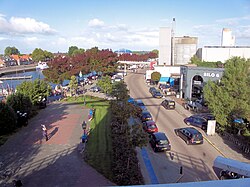 Harderwijk, Harbour of Harderwijk seen from windmill De Hoop
 -
 Harderwijk, defensive wall, cannon and church tower
 -
 Harderwijk, windmill
 -
 Harderwijk: het Linnaeustorentje (the Linnaeus tower)


References
[edit]- ^ "Samenstelling" [Members] (in Dutch). Gemeente Harderwijk. Retrieved 17 June 2014.
- ^ "Kerncijfers wijken en buurten 2020" [Key figures for neighbourhoods 2020]. StatLine (in Dutch). CBS. 24 July 2020. Retrieved 19 September 2020.
- ^ "Postcodetool for 3841AA". Actueel Hoogtebestand Nederland (in Dutch). Het Waterschapshuis. Archived from the original on 21 September 2013. Retrieved 17 June 2014.
- ^ "Bevolkingsontwikkeling; regio per maand" [Population growth; regions per month]. CBS Statline (in Dutch). CBS. 1 January 2021. Retrieved 2 January 2022.
- ^ Stenvert, R. et al. (2000). Monumenten in Nederland: Gelderland, p. 50 and 183–188. Zwolle: Waanders Uitgevers. ISBN 90-400-9406-3
- ^ IMDb Database retrieved 10 March 2020
External links
[edit] Media related to Harderwijk at Wikimedia Commons
- Chisholm, Hugh, ed. (1911). . Encyclopædia Britannica. Vol. 12 (11th ed.). Cambridge University Press. p. 942.
- Official website

Places adjacent to Harderwijk | ||||||||||||||||
|---|---|---|---|---|---|---|---|---|---|---|---|---|---|---|---|---|
| ||||||||||||||||


Members of the Hanseatic League by quarter, and trading posts of the Hanseatic League | ||||
|---|---|---|---|---|
| ||||
| Wendish |
|   | ||
| Saxon | ||||
| Baltic | ||||
| Westphalian | ||||
| Kontore | ||||
| Vitten | ||||
| Factories | ||||

| International | |
|---|---|
| National | |
| Geographic | |
| Other | |

Harderwijk
View on GrokipediaGeography and Environment
Location and Topography
Harderwijk is situated in the province of Gelderland in the central-eastern part of the Netherlands, with geographic coordinates of approximately 52°21′N 5°37′E.[8] The city occupies a strategic position on the southwestern shore of the Veluwemeer, a lake connected to the IJsselmeer, historically part of the Zuiderzee inlet from the North Sea.[9] To the south and southeast, it adjoins the Veluwe, an extensive area of forests, heathlands, and sand dunes.[10] The topography features low-lying flatlands typical of reclaimed coastal regions, with the city center at an elevation of roughly 3–4 meters above sea level.[11] [12] Southeastward, the terrain gradually rises into the more varied and elevated landscapes of the Veluwe, where average municipal elevations reach about 7 meters, with forests dominating the higher ground.[13] These subtle height differences between the watery lowlands and inland Veluwe have shaped agricultural and urban development.[14] The municipality spans 48.27 km², including significant water bodies comprising about 19% of the area, underscoring its maritime-influenced geography.[15]Climate and Natural Features
Harderwijk has a temperate oceanic climate (Köppen Cfb), with mild winters, cool summers, and precipitation fairly evenly distributed across the year, though slightly higher in summer. Average high temperatures range from 6°C in January to 22°C in July, with lows around 2°C in winter and 13°C in summer; annual mean temperature is approximately 10°C. Annual precipitation averages 800 mm, influenced by westerly winds from the North Sea via the IJsselmeer.[16][17][18] The landscape is low-lying and flat, with elevations typically between 0 and 7 meters above sea level and minimal relief, characteristic of reclaimed Dutch polder terrain. Northern boundaries adjoin the IJsselmeer, specifically the shallow Wolderwijd bay (average depth 1.5 m), fostering wetlands and supporting water-based recreation and biodiversity.[19][18][20] To the southeast, the municipality extends into the Veluwe, a glacial moraine region featuring dense forests, heathlands, and sand dunes that host diverse ecosystems, including coniferous and deciduous woodlands with species like Scots pine and oak, alongside wildlife such as red deer and birds of prey. This contrast between aquatic northern fringes and inland wooded uplands shapes local natural features and provides recreational trails through varied habitats.[10][21]Demographics
Population Trends
The population of Harderwijk municipality has experienced consistent growth since the mid-20th century, reflecting broader Dutch suburbanization patterns and residential expansion near the Veluwe region. In 1959, the figure stood at 16,438 inhabitants, following post-war recovery and initial housing developments like the Tweelingstad neighborhood.[22] By 1995, it had more than doubled to 36,909, driven by further urban extensions such as Stadsdennen (1961) and Slingerbos (1966).[22] [23] This upward trajectory continued into the 21st century, with the population reaching 39,745 in 2000, 44,010 in 2010, 45,776 in 2015, and 48,414 in 2020.[23] The average annual growth rate from 1995 to 2020 averaged approximately 1.3%, primarily attributable to net internal and international migration rather than natural increase.[23] In 2023, the municipality added 391 residents net, outpacing the Gelderland provincial average, with the total reaching 48,726.[24][25] By late 2024, it approached 50,000, with projections estimating 50,042 by 2025.[23] Key population milestones are summarized below:| Year | Population |
|---|---|
| 1959 | 16,438 |
| 1995 | 36,909 |
| 2000 | 39,745 |
| 2010 | 44,010 |
| 2020 | 48,414 |
| 2023 | 48,726 |
| 2025* | 50,042 |