

Community hub
Recent from talks
Contribute something
Nothing was collected or created yet.
Miliana
View on WikipediaMiliana (Arabic: مليانة) is an Algerian commune in the Aïn Defla province, serving as the capital of Miliana district approximately 114 kilometres (71 mi) southwest of the Algerian capital, Algiers.[2] It is located south of Dahra, on the slopes of Mount Zaccar, overlooking the Chelif Valley.
Key Information


Founded in the 10th century by the Zirid prince Bologhine son of Ziri on the ruins of the Roman city Zucchabar, Miliana lost prominence during the colonial period. Its old town, with several monuments, is a preserved heritage site. Its population descends from Dahra Berbers, Arabs, Andalusians, and Jews.[3]
Geography
[edit]Location
[edit]The commune of Miliana is located in the north of the Aïn Defla wilaya. The town is located 114 km to the southwest of Algiers, 50 km to the west of Médéa, and 92 km to the east of Chlef.
Neighboring Communes of Miliana | ||||||||||||||||
|---|---|---|---|---|---|---|---|---|---|---|---|---|---|---|---|---|
| ||||||||||||||||
Topography
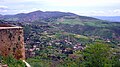
[edit]Due to its position in mountainous terrain, the elevation of Miliana differs greatly, ranging from 430 metres (1,410 ft) to 870 metres (2,850 ft). It is built on a rocky shelf with steep edges on the southern slopes of Mount Zaccar Rherbi[fr], which covers its entire northern border and reaches 1,550 metres (5,090 ft). There is also a smaller ridge to the south that reaches 700 metres (2,300 ft), separating Miliana from Khemis Miliana. The area around the town is well forested. To the east and south is the Chélif River Valley, and to the west is a large plateau that stretches to the Ouarsenis range.
Climate
[edit]Miliana has a Mediterranean climate (Köppen climate classification Csa), with hot, dry summers and mild, wet winters.
| Climate data for Miliana (1991-2020) | |||||||||||||
|---|---|---|---|---|---|---|---|---|---|---|---|---|---|
| Month | Jan | Feb | Mar | Apr | May | Jun | Jul | Aug | Sep | Oct | Nov | Dec | Year |
| Record high °C (°F) | 23.8 (74.8) |
27.3 (81.1) |
31.0 (87.8) |
33.8 (92.8) |
38.7 (101.7) |
42.4 (108.3) |
43.7 (110.7) |
45.2 (113.4) |
40.6 (105.1) |
37.4 (99.3) |
30.4 (86.7) |
24.9 (76.8) |
45.2 (113.4) |
| Mean daily maximum °C (°F) | 12.7 (54.9) |
13.7 (56.7) |
16.9 (62.4) |
19.8 (67.6) |
24.6 (76.3) |
30.3 (86.5) |
34.9 (94.8) |
34.8 (94.6) |
29.5 (85.1) |
24.3 (75.7) |
17.1 (62.8) |
13.6 (56.5) |
22.7 (72.9) |
| Daily mean °C (°F) | 9.3 (48.7) |
9.9 (49.8) |
12.7 (54.9) |
15.1 (59.2) |
19.4 (66.9) |
24.5 (76.1) |
28.6 (83.5) |
28.6 (83.5) |
23.9 (75.0) |
19.4 (66.9) |
13.4 (56.1) |
10.3 (50.5) |
17.9 (64.2) |
| Mean daily minimum °C (°F) | 5.9 (42.6) |
6.2 (43.2) |
8.4 (47.1) |
10.5 (50.9) |
14.2 (57.6) |
18.6 (65.5) |
22.3 (72.1) |
22.3 (72.1) |
18.3 (64.9) |
14.6 (58.3) |
9.7 (49.5) |
7.0 (44.6) |
13.2 (55.8) |
| Record low °C (°F) | −5.8 (21.6) |
−3.6 (25.5) |
−2.3 (27.9) |
1.3 (34.3) |
3.4 (38.1) |
8.7 (47.7) |
14.0 (57.2) |
13.0 (55.4) |
10.0 (50.0) |
2.6 (36.7) |
1.3 (34.3) |
−1.0 (30.2) |
−5.8 (21.6) |
| Average precipitation mm (inches) | 122.8 (4.83) |
94.9 (3.74) |
95.3 (3.75) |
69.6 (2.74) |
43.3 (1.70) |
11.1 (0.44) |
3.9 (0.15) |
8.4 (0.33) |
27.7 (1.09) |
47.7 (1.88) |
97.1 (3.82) |
100.2 (3.94) |
722.0 (28.43) |
| Average precipitation days (≥ 1 mm) | 10.4 | 9.3 | 8.0 | 7.3 | 5.2 | 1.5 | 0.7 | 1.2 | 3.5 | 5.5 | 9.4 | 9.1 | 71.1 |
| Mean monthly sunshine hours | 171.1 | 177.6 | 224.1 | 249.8 | 295.9 | 335.6 | 355.3 | 329.8 | 259.7 | — | 172.5 | 159.4 | — |
| Source: NOAA[4] | |||||||||||||
Toponymy
[edit]
Miliana corresponds[5][6] to the town of Punic origin known in Roman times as Zucchabar. Under Augustus, it was given the rank of colonia and was thus referred to as Colonia Iulia Augusta Zucchabar.[7] The Greek form of the name used by the geographer Ptolemy was Ζουχάββαρι (Zuchabbari).[8] Pliny the Elder calls it "the colony of Augusta, also called Succabar",[9] and Ammianus Marcellinus gives it the name Sugabarri or (in adjectival form) Sugabarritanum.[10][11][12]
Zucchabar belonged to the Roman province of Mauretania Caesariensis.[5][6][9] The film Gladiator mentioned a Roman province of Zucchabar, which did exist in fact .
The names Zucchabar or Sugabar were mentioned on epigraphic monuments nearby, indicating the place's belonging to a larger city.[13] This name may be of Phoenician or Libyco-Berber origin, meaning "wheat market."
The name Manliana or Malliana is cited in antiquity as an urban area located at the current site of the town or in the surrounding area, and Saint Augustin refers to a bishop of this city.[14] According to some, this name is derived from Latin and is attributed to the daughter of a patrician Roman family (Manlia) which owned large domains in the agricultural region of the Chélif River valley.
With the Muslim Conquest, the name "Manliana" was arabized to become Mel-Ana, meaning "full of richesses," then Milyana.[15]
History
[edit]Antiquity
[edit]For a long time Miliana was the sanctuary capital of the Numidian kings. In 105 BCE Jugurtha was captured not far from this region.[16]
A Roman garrison was established in Zucchabar by Emperor Augustus between 27 and 25 BCE. The city is mentioned by Ammianus Marcelinus during the insurrection of the Berber leader Firmus in 375; the Roman general Theodosius the Elder left Caesarea (now Cherchell) to occupy Sugabarritanum.[17]
Zucchabar was an important city in the province of Mauretania Caesariensis and became a Christian episcopal see. The names of two of its Catholic bishops and one Donatist are recorded:[18]
- Maximianus, who attended the Conference of Carthage (411);
- Germanus, the Donatist bishop who attended the same conference;
- Stephanus, one of the Catholic bishops whom Huneric summoned to a meeting in Carthage in February 484 and then exiled.
The bishopric is included in the Catholic Church's list of titular sees.[19]
In the 5th century, with the arrival of the Vandals, the Roman city was abandoned along with most of its ancient monuments.
Medieval Muslim Algeria
[edit]
Between 972 and 980, Prince Buluggin ibn Ziri, founder of Algiers and Médéa, constructed a medina atop the ruins of the Roman city. During this period, the city experienced a renaissance and great prosperity.[20] It is mentioned by several Muslim geographers. In the 10th century, Ibn Hawqal was the first to reference the city in his writings. He describes it as "Ancient city, equipped with water-mills turned by its waterway and possessing a large number of irrigation canals."[21] In the 11th century, Al-Bakri wrote that Miliana was one of the cities constructed by Buluggin, along with Algiers and Médéa. In the 14th century, Ibn Khaldun described the city as "part of the Maghrawa Beni Warsifen domain in the Chélif River plain," and that Buluggin had drawn the map for El Djezaïr, Melyana and Lemdiya. Throughout this period, Miliana was a haven of culture. It held a large number of scholars in different fields and scientists, including Ahmed Ben Otmane El Meliani, 13th century writer and poet, and Ali Ben Meki El Miliani, 14th century theologian and jurist.[22]
The city was in the territory of the Maghrawa tribe.
Like other cities in the Maghreb, Miliana underwent several conquests as well as political turmoil. In 1081, Yusuf Ibn Tashfin, leader of the Almoravids, occupied Algiers, Médéa, and Miliana. Afterward, the city was integrated into the Almohad Caliphate in 1149.[16] In 1184, the Banu Ghaniya seized the city along with others in the central Maghreb. The following year, the Almohads reclaimed their territory, and the Banu Ghaniya withdrew from Ifriqiya.[23]
In 1238, the Hafsids of Tunis supported their allies, the Banu Tudjin, in their possession of the city. In 1261, Abou Hafs, brother of the Hafsid emir of Tunis, laid siege to the city and conquered it with forces that included mercenary Christian knights led by the exile Henry of Castile. In 1268, the Zayyanid sovereign Yaghmurassen Ibn Zyan attempted to occupy the region of Miliana; the city would only become occupied by the Tlemcen kings in 1308 when the Abd al-Wadids imposed their authority over Miliana and nearly all the cities in the central Maghreb. During the fall of the Zayyanid Kingdom, one of this dynasty's prince seized Miliana, Médéa, and Ténès in 1438, but he was killed by his son who became the king of Ténès.[24]
In 1517, Oreç Reis seized the city and the Chélif River valley; Miliana became an Ottoman caidat. However, the region saw many uprisings against the Ottoman rule during this period, notably that of Bouterik, sheik of the Soumata tribes in 1544.[16]
French Colonization
[edit]
After the Invasion of Algiers in 1830, the French encountered resistance from the population who pledged allegiance to Emir Abdelkader, who established a caliphate in Miliana in 1835. The Peace Treaty of Desmichels guaranteed Emir Abdelkader the right to take possession of Miliana starting in 1835 where he was warmly welcomed by the city's general population and prominent citizens.
Due to its geostrategic position, Miliana became a caliphate governed by the caliph Mohieddine Seghir[fr] (1835-1837) and then Ben Allel[fr] (1837-1840) who led 10,440 combattants. The emir built several establishments there, including the caliphate seat and an arms manufactory.[16]
The city was occupied in 1840 by Marshal Valée's troops, but the garrison was sieged several times by Ben Allel and local tribes. Reinforcements were therefore dispatched from Algiers by Marshal Bugeaud to support those under siege.[25] Abdelkader ordered Miliana burned rather than surrendering to the French. The town eventually fell under French control in 1842.[26] Ben Allel died in 1843 and the French troops burned the city in 1844 to drive out the emir's followers.[20] It was rebuilt in the French Colonial architectural style.[2]
Emperor Napoleon III visited Miliana in 1865. In 1901, the Righa tribes of Aïn Torki revolted, under the direction of Sheikh Yakoub.[16]
During this period, the city was marginalized in favor of the colonially created Khemis Miliana.[27]
In 1957 during the Algerian War a battle took place at the Oued Guergour to the south of Miliana between the mujahideens and the French army.
From 1874 to 1975 up to 2000 people worked in an underground iron ore mine on Mont Zaccar, which transported the ore and passengers by the 9 kilometres (5.6 mi) Miliana-Margueritte Tramway to the nearest PLM railway station in Miliana-Margueritte.
Demographics
[edit]Miliana is an old city, populated by the descendants of Arabs, Moriscos, Kouloughlis, and Berbers of the Mount Zaccar region.[15]
Miliana is the fourth most populous commune in the wilaya of Aïn Defla, after Khemis Miliana, Aïn Defla, and El Attaf, and according to the 2008 Algerian Census, the population of the commune is registered at 44,201 residents as opposed to 22,528 in 1977:
| Year | 1977 | 1987 | 1998 | 2008 |
|---|---|---|---|---|
| Population | 22,528 | 27,183 | 39,662 | 44,201 |
Town structure
[edit]
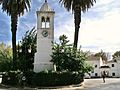
The center of Miliana has a Muslim quarter and a French quarter, both of which are surrounded by city walls built on Turkish and Arab foundations. The main site in the Muslim quarter is the Mosque of Sidi Ahmed ben Yousef. Built in the Moorish style, the mosque is the location of a biannual pilgrimage. The Muslim quarter also contains a covered marketplace. The modern section of the town center, known as the Place Cornot (or Place de l'Horloge), is shaded by trees and contains a clock tower, formerly a minaret.[2][26]
Economy
[edit]Miliana is primarily an agricultural town. Its vineyards, orchards and gardens, which lie below the town center, are fed by water from nearby mountains that usually have snow in winters. Hydroelectricity is used to power tile factories, flour mills and other light industries.[2][26]
Recreation
[edit]The game of El Koura is a traditional game that was played in Miliana, Laghouat and other places prior to French colonization. Similar to association football,[29] the game was played during the spring and times of extreme drought because it was believed to bring rain.[30] After French colonization, European sports, especially association football, became more popular.[29]
The town is home to Algerian club football team S.C. Miliana.[31]
Culture
[edit]
Miliana is home to several musical groups who specialize in different Algerian musical genres: Andalusian, Chaabi, and Zurna.[32] It hosts an Andalusian music festival, which brings together musicians from the three Algerian schools of music: Sanâa[fr] of Algiers, Gharnati of Tlemcen, and Ma'luf of Constantine.[33]
The celebration of Mawlid al-Nabi (celebrating the birth of Muhammed) in Miliana stands out because of the crafting of m'narette, wooden and reed models of mosques, towers, and boats. On the eve of Mawlid, a parade of m'narette, lit up with candles and decorated with sweets and fruits, makes its way to the Sidi Ahmed Benyoucef mosque.[34]
Miliana's Rekb is a regional tradition of the Berber tribe of Beni Farah, an annual pilgrimage to the interior of the mausoleum of Sidi Ahmed Benyoucef. Hundred of pilgrims come from several regions throughout the country to make their journey from the city of Messelmoun (Tipaza wilaya) to the saint's mausoleum.[35]
Miliana's Cherry Festival is an annual socio-cultural event established during colonization and has been maintained since independence. It takes place during the last week of June. The festival allows the citizens of Miliana to celebrate the qualities of Miliana's cherries, and enables visitors to discover the city's customs and to try the different confections mades from cherries. The festival experienced a decade-long hiatus, then was once more celebrated as part of a plan to revive specific local celebrations in the Aïn Defla wilaya.[36] Cherry production greatly declined along with other horticulture; construction and the destructuring of the city's gardens are the principal cause.
Local Sites
[edit]Some monuments from the 18th and 19th centuries remain today. The former home of Emir Abdelkader is a Moorish style building located in the city center, restored and transformed into the museum of Miliana.[37] It contains several exposition halls on the history of the region, including archeological artifacts from the Roman and Muslim periods, the popular revolts against French conquest, and also ethnographic objects from Southern Algeria.
The Sidi Ahmed Benyoucef Mosque is dedicated to the saint Abu El-Abbas Ahmed Benyoucef Errachidi, a mystic figure born in Kalaa near Mascara in the mid-15th century, who died in 1526 and was interred in Miliana in 1774 by Mohamed El-Kebir, the bey of Oran. The minaret El-Batha was part of a previous mosque called djemâa El-Turk or djemâa El-Batha; this mosque was destroyed around 1844 for the construction of a public square and its minaret was transformed into a clocktower.[37]
Emir Abdelkader's arms manufactory, located in a suburb of the city, was erected by the emir around 1839. The ramparts, according to some sources, are ancient in origin, but they have undergone many transformations, particularly for the extension of the colonial city.[37] The city contains a large public garden created in 1890.[20]
-
 City center; clocktower and museum
 -
 Emir Abdelkader Museum
 -
 Ramparts and suburbs
 -
 The Place Ammar Ali overlook
 -
 El-Batha minaret
 -
 Museum of Miliana
 -
 Emir Abdelkader's home
 -
 Miliana's public garden
 -
 Mausoleum of the Saint


Notable people associated with Miliana
[edit]- Sidi Ahmed Benyoucef Errachidi (1435–1524), whose mausoleum was classified a historic monument in 1978.
- Mohamed Charef (1908-2011), theologian and mufti.
- Mohamed Belhocine (born 1951), Algerian medical scientist, professor of internal medicine and epidemiology.
- Mustapha Ferroukhi[fr], resistance fighter.
- Mohamed Bouras[fr], founder of the Algerian Muslim Scouts.
- Ali Ammar known as Ali La Pointe (1930-1957), resistance fighter and martyr of the Algerian Revolution. Hero of the Battle of Algiers.
- Augustin Ferrando[fr] (1880–1957), Orientalist painter, director of the School of Fine Arts in Oran.
- Marcello Fabri[fr] (1889–1945), poet and Orientalist painter, essayist, philosopher, art critic, playwright, founder of two journals.
- Mohammed Benchicou (1952-), eminent journalist
- Alphonse Daudet (1840-1897), writer, visited here. In his Letters from My Windmill, there is a short story entitled "À Milianah."
- Lantri Elfoul (1936-2012), professor of translation, author of Miliana la mémoire, 2009 (Casbah éditions) and Traité de traductologie, 2006 (Casbah éditions), born and raised in Zougala, Miliana.
- Walter Amsallem[fr] (1931-), former mayor of Beauvais (1977-2001), born in Miliana
- Pierre Bolotte[fr] (1921-2008), sub-prefect of Miliana
- Jean Kay[fr] (1943-2012), adventurer and writer
- Mahfoud Ferroukhi[fr] (1953-), Algerian archeologist.
- Mustapha Tounsi[fr] (1939-2018), officer in the ALN (National Liberation Army) and writer
- Noureddine Ferroukhi[fr] (1959-2019), plastic artist and teacher.
References
[edit]- ^ "Algeria – largest cities". World Gazeteer. Archived from the original on 12 April 2013. Retrieved 11 February 2013.
- ^ a b c d Miliana(Algeria) Archived 2014-01-03 at the Wayback Machine. Encyclopædia Britannica Online. Retrieved October 3, 2010.
- ^ Basset, Rene (2010). Etude Sur La Zenatia De L'Ouarsenis, Et Du Meghreb Central (1895) [Study on the Zenatia of Ouarsenis, and Central Meghreb (1895)] (in French). Kessinger Publishing. ISBN 978-1166823825.
- ^ "Miliana Climate Normals 1991–2020". World Meteorological Organization Climatological Standard Normals (1991–2020). National Oceanic and Atmospheric Administration. Archived from the original on 27 September 2023. Retrieved 27 September 2023.
- ^ a b "Werner Huß "Succhabar" in Brill's New Pauly (2011)". Archived from the original on 2016-03-05. Retrieved 2014-03-24.
- ^ a b Miliana ville historique Archived 2014-03-24 at the Wayback Machine
- ^ "T.W. Potter, "Zucchabar"". Archived from the original on 2024-05-22. Retrieved 2014-03-24.
- ^ Ptolemy, Book 4, chapter 2 (page 95 in the translation by Edward Luther Stevenson (New York, 1932) Archived 2014-03-24 at the Wayback Machine
- ^ a b "Pliny, Natural Histories, book 5, chapter 1". Archived from the original on 2021-03-04. Retrieved 2021-02-20.
- ^ "Ammianus Marcellinus, Roman History, XXIX, V, 25 and 20". Archived from the original on 2024-05-22. Retrieved 2014-03-24.
- ^ Jan den Boeft, Jan Willem Drijvers, Daniël den Hengst, Hans Teitler (editors), Philological and Historical Commentary on Ammianus Marcellinus XXIX (Brill 2013 Archived 2024-05-22 at the Wayback Machine ISBN 978-90-0426787-9), p. 179
- ^ "George Sale, George Psalmanazar, Archibald Bower, George Shelvocke, John Campbell, John Swinton An Universal History, from the Earliest Account of Time (T. Osborne 1748), p. 313". Archived from the original on 2024-05-22. Retrieved 2023-03-17.
- ^ Haddadou, M A. "Mon beau pays, Miliana". DjaZairess (in French).
- ^ Noubi, K. "Une ville, une histoire". DjaZairess (in French).
- ^ a b "Miliana la bienheureuse..." DjaZairess (in French).
- ^ a b c d e Historical markers in the Emir Abdelkader municipal museum of Miliana
- ^ Ammianus Marcellinus. Thayer, Bill (ed.). "Book XXIX, Roman HIstory". LacusCurtius. Reproduced from Loeb Classical Library: 1939. Archived from the original on 2024-05-22. Retrieved 2021-02-19.
- ^ Stefano Antonio Morcelli, Africa christiana, Volume I, Brescia 1816, p. 371]
- ^ Annuario Pontificio 2013 (Libreria Editrice Vaticana, 2013, ISBN 978-88-209-9070-1), p. 1013
- ^ a b c Babo, Daniel. Algérie. Brestin, Olivier, Sèbe, Alain. Paris, France. ISBN 978-2-911328-96-1. OCLC 896837368.
- ^ Haddadou, M A. "Mon bon pays, Miliana (II)". DjaZairess (in French).
- ^ "Histoire: Période arabo-musulmane". miliana.com (in French).
- ^ Meynier, Gilbert, (1942- ...). (2010). L'Algérie, coeur du Maghreb classique : de l'ouverture islamo-arabe au repli, 698-1518. Paris: La Découverte. ISBN 978-2-7071-5231-2. OCLC 690879697.
{{cite book}}: CS1 maint: multiple names: authors list (link) CS1 maint: numeric names: authors list (link) - ^ Chitour, Chems-Eddine (2004). Algérie : le passé revisité : une brève histoire de l'Algérie (2. éd. rev. corr. et complétée ed.). Alger: Casbah Editions. ISBN 9961-64-496-4. OCLC 64130484.
- ^ Stora, Benjamin (2004). Histoire de l'Algérie coloniale : 1830-1954 (Nouv. éd ed.). Paris: La Découverte. ISBN 2-7071-4466-5. OCLC 419827295.
- ^ a b c Miliana Archived 2020-09-23 at the Wayback Machine. LookLex Encyclopaedia. Retrieved on October 3, 2010.
- ^ Côte, Marc, 1934- ... (1996). Guide d'Algérie : paysages et patrimoine. Algérie: Media-plus. ISBN 9961-922-00-X. OCLC 468677352.
{{cite book}}: CS1 maint: multiple names: authors list (link) CS1 maint: numeric names: authors list (link) - ^ url=https://citypopulation.de/php/algeria-admin.php?adm2id=4402 Archived 2024-05-22 at the Wayback Machine
- ^ a b Sato, Daisuke. "Sport and Identity in Tunisia Archived 2011-07-22 at the Wayback Machine." International Journal of Sport and Health Science Vol 3 (2005): 27-34. Retrieved October 3, 2010.
- ^ Hartland, E. Sidney. "Games." Encyclopedia of Religion and Ethics Part 11. Whitefish, Montana: Kessinger, 2003. 167-71.
- ^ Algeria Archived 2010-03-22 at the Wayback Machine. Club-Soccer.com. Retrieved October 3, 2010.
- ^ H, M'hamed. "Miliana. Associations culturelles locales". DjaZairess (in French). Originally published in El Watan, March 6, 2007.
{{cite web}}: CS1 maint: postscript (link) - ^ Baba Hadji, Farouk. "Une manifestation qui manque de souffle". DjaZairess (in French). Originally published in Le Midi Libre, April 20, 2008.
{{cite web}}: CS1 maint: postscript (link) - ^ L, Aziza. "Miliana: M'narette pour El Mawlid". DjaZairess (in French).
- ^ L, Aziza. "Entre un passé glorieux et une amère réalité". DjaZairess (in French). Originally published in El Watan, May 25, 2009.
{{cite web}}: CS1 maint: postscript (link) - ^ "Retour en juin de la Fête des cerises de Miliana". DjaZairess (in French). Originally published in El Watan, Feb 17, 2009.
{{cite web}}: CS1 maint: postscript (link) - ^ a b c Amir, Aziza. "Miliana, Histoire des Monuments". DjaZairess (in French). Originally published in Info Soir, July 28, 2003.
{{cite web}}: CS1 maint: postscript (link)
.svg)
| International | |
|---|---|
| National | |
| Other | |
Miliana
View on GrokipediaMiliana is a commune and the seat of Miliana District in Aïn Defla Province, northwestern Algeria. Located at approximately 36°18′N 2°14′E in the northern Tell Atlas Mountains with an elevation of 662 meters, the town covers 55 square kilometers and recorded a population of 43,366 in the 2008 census.[1][2] Originally established by the Zirid dynasty in the 10th century on the site of the ancient Roman city of Zuccabar, Miliana features historical architecture and sites linked to regional Berber and Islamic heritage, including structures from the Ottoman period and remnants of colonial-era fortifications.[3] The town holds significance in Algerian history for its association with resistance figures, such as the residence of Emir Abdelkader during conflicts with French forces in the 19th century, and later contributions to the independence struggle through local fighters like Ali La Pointe.[4]
Geography
Location
Miliana is situated in northwestern Algeria, within Aïn Defla Province, approximately 114 kilometers southwest of the national capital, Algiers.[5] The city serves as the administrative center of Miliana District in the province.[6] Its geographic coordinates are 36°18′21″ N, 2°13′35″ E.[7] The straight-line distance to Algiers is about 93 kilometers, while the driving distance along primary routes measures roughly 116 kilometers.[8] Miliana occupies a position in the central Tell region, bordered by the Dahra Mountains to the north and the High Plateaus to the south.[5]Topography
Miliana occupies a rocky plateau at an average elevation of 740 meters above sea level, situated on the southern slopes of Mount Zaccar within the Dahra Massif.[9] The terrain is characterized by abrupt contours and a protruding rocky platform, reflecting its position in the rugged mountainous landscape of northern Algeria.[9] Elevations across the commune range from a minimum of approximately 400 meters to a maximum of 1,000 meters, contributing to a varied topography that includes steep gradients and elevated vantage points. The city lies about five kilometers north of the Chelif River, overlooking the river valley and the plains extending toward the Ouarsenis mountain range to the south.[10] This strategic positioning on the northern rim of the Chelif basin has historically influenced settlement patterns and defensive structures.[9]Climate
Miliana has a Mediterranean climate classified as Csa under the Köppen system, featuring hot, dry summers and mild, wetter winters influenced by its elevation of approximately 721 meters.[11] This results in significant seasonal temperature variations, with average highs reaching 32.2°C in August and dropping to 11.7°C in January, while lows range from 21.1°C in summer to 5.5°C in winter.[11] [12] Precipitation totals average around 500–800 mm annually, concentrated primarily from October to April, supporting local agriculture and vegetation during the cooler months. The wettest period occurs in February with up to 124 mm of rainfall, whereas summers are arid, with July recording as little as 6 mm.[11] [13] Historical data from the Miliana meteorological station (1957–2023) indicate variability, with yearly precipitation ranging from 303 mm in drier years like 1983 to over 600 mm in wetter ones like 1982, alongside 16–20°C mean annual temperatures.[13] Humidity peaks during the muggy summer period from late June to early October, while winds are generally moderate, strongest in December at about 13 km/h. These patterns contribute to a relatively comfortable climate for the region, though occasional extremes, such as summer highs near 34°C or winter frosts, occur due to inland positioning away from coastal moderation.[12][11]Etymology and Toponymy
[Etymology and Toponymy - no content]History
Antiquity and Pre-Islamic Era
The site of modern Miliana was occupied in antiquity by the ancient town of Zucchabar, located in the Roman province of Mauretania Caesariensis.[3] The settlement had Punic origins, reflecting Phoenician and Carthaginian influence in the region prior to Roman dominance.[3] Zucchabar served as a refuge for Numidian kings during the pre-Roman Berber period and was incorporated into the expanding Roman sphere in the 1st century BC.[14] In 27 BC, Emperor Augustus fortified the town and established it as a veterans' colony, integrating it into the administrative and military structure of Roman North Africa.[3] Epigraphic evidence attests to its Roman municipal status, including references to the colonia Iulia Augusta Zucchabar.[15] The town persisted through the later Roman Empire, with agricultural development prominent in the 4th–7th centuries AD under Romanized Berber populations, before the site's prominence waned amid the Vandal and Byzantine interregnums.[14] Archaeological remains, though largely unexcavated due to overlying modern construction, confirm continuity of settlement until the early medieval Arab conquests disrupted the pre-Islamic Berber-Roman framework.[3]Medieval Islamic Period
Miliana came under Muslim control following the Arab conquests of the 8th century, with the region initially governed by the Rustamid imamate from 160 AH/777 AD to 281 AH/894 AD, during which the site's strategic position along trade routes placed it within their domain.[16] Subsequent oversight by the Aghlabids saw Miliana referenced as a provincial center by al-Yaʿqūbī in 278 AH/891 AD.[16] In the late 10th century, Būlukkīn ibn Zīrī, son of the Zirid founder Zīrī ibn Manād, occupied and developed Miliana atop the Roman ruins of Zucchabar, establishing it as a fortified settlement and political outpost for the Sanhaja Zirid dynasty amid their campaigns against local Zanata tribes and Fatimid rivals. The Zirids renovated the town, integrating it into their Ifriqiyan domain until the early 11th-century schism that birthed the Hammadid emirate; under Hammadid rule from circa 1014, Miliana served as an administrative hub in the western territories, governed by figures like Kbab during the reign of al-Nāṣir ibn ʿAlannās (r. 1062–1088).[16] The Almohads incorporated Miliana following their conquest of the Hammadid capital al-Qalʿa in 1152, marking the town's alignment with the caliphate's centralizing reforms across the Maghrib.[17] This period of stability was interrupted in 1184 when the Banū Ghāniya, Almoravid exiles from the Balearics, briefly seized Miliana alongside Algiers and Ashir in their insurgency against Almohad authority, using Béjaïa as a launch point before Almohad forces reasserted control.[17] By the 13th century, amid Almohad fragmentation, Miliana transitioned into the orbit of emerging regional powers, including the Zayyanids of Tlemcen, who exerted influence over central Algerian highlands through military expeditions and alliances.[16]Ottoman Era
Miliana was incorporated into the Ottoman Regency of Algiers following its conquest by Aruj Barbarossa, who seized the city shortly after capturing Algiers in 1516, extending control over the Chélif Valley region.[18][19] This marked the transition from local Berber and Zirid-influenced autonomy to direct Ottoman administration, with the town designated as a caidat under a local governor (caid) responsible to the Pasha in Algiers.[19] Under Turkish rule, Miliana formed part of the dār al-sulṭān, the central domain directly governed from Algiers, distinct from the semi-autonomous beyliks. Turkish officers maintained a permanent presence, enforcing annual tax collection enforced by detachments dispatched from the capital, which eroded the inhabitants' prior near-complete independence.[19] By the 18th century, the town integrated into the Beylik of Titteri, with its capital at Médéa, where Ottoman beys oversaw regional administration, including the construction of religious and communal structures such as the Zawiya of Sidi Ahmed Ben Youssef, attributed to Bey Mohamed El Kebir. Ottoman archival records from the period document local family genealogies, property endowments (waqfs), including those by women, reflecting social and economic structures under Turkish influence.[20] The town's medina retained cobbled lanes and fortifications adapted during Ottoman governance, serving as a regional center amid the Regency's corsair economy and internal tribal dynamics, though specific local uprisings remain sparsely documented beyond broader regional resistances to central authority. Ottoman control persisted until the French invasion of 1830, after which the beylik structure briefly resisted before Miliana's direct French occupation in 1840.[21][19]French Colonial Period (1830–1962)
French forces under Marshal Sylvain Charles Valée occupied Miliana on December 25, 1840, following its deliberate destruction by retreating troops loyal to Emir Abdelkader to deny the invaders a usable base.[22] The city, found in ruins with its infrastructure burned, exemplified the scorched-earth tactics employed by Algerian resistance leaders during the early conquest phase. This occupation marked the extension of French control into the inland Dahra region, part of broader pacification efforts that involved military garrisons and initial administrative imposition amid ongoing tribal opposition.[23] Post-occupation, French authorities initiated reconstruction of Miliana's urban core, aligning with policies to rebuild inland cities captured between 1837 and 1842 for strategic consolidation.[23] The pre-colonial Jewish quarter (Darb al-Yahūd) persisted initially, though the synagogue suffered damage during the evacuation under Abdelkader; subsequent French rule facilitated Jewish integration via decrees like Crémieux in 1870, though local dynamics retained distinct communal spaces until later assimilation pressures.[24] Agriculture, particularly gardens and orchards, remained economically vital, as noted in historical accounts from the conquest era, supporting both local sustenance and emerging colonial exports.[25] Miliana's prominence waned under French rule, overshadowed by newly established colonial settlements such as Khemis Miliana, which drew administrative and settler focus as a modern hub. Integrated into the Department of Algiers within French Algeria's tripartite structure (Algiers, Oran, Constantine departments), the town functioned under military governance transitioning to civilian administration by the mid-19th century, with infrastructure like roads and fortifications enhancing connectivity to coastal centers.[23] Population growth included European settlers, though Miliana retained a majority Algerian demographic, with economic activities centered on agrarian production rather than large-scale industrialization.[25] By the late colonial era, urban planning reflected French priorities, as evidenced by maps from the 1950s depicting expanded layouts amid simmering tensions preceding the independence struggle.[25] Local resistance persisted sporadically, including sieges on the garrison by figures like Ben Allel and allied tribes in the 1840s, underscoring incomplete pacification. Overall, the period entrenched extractive colonial structures, prioritizing settler interests while marginalizing indigenous economic and political agency until decolonization pressures mounted post-World War II.[23]Algerian War of Independence (1954–1962)
During the Algerian War of Independence, Miliana and its environs served as sites of intermittent guerrilla engagements between Front de Libération Nationale (FLN) fighters and French military forces, reflecting the broader pattern of rural insurgency in Algeria's interior regions. On October 11, 1957, a clash occurred at Oued Guergour south of Miliana, where FLN mujahideen confronted French troops; following the battle, French forces reportedly executed captured fighters publicly in Miliana's main square, highlighting the brutal tactics employed by both sides in suppressing resistance. Further skirmishes erupted near Miliana, alongside nearby locales like Tablat and Ténès, from February 24 to 26, 1958, resulting in approximately 45 rebel deaths and 44 French military casualties, as French units conducted sweeps to disrupt FLN supply lines and hideouts in the Chelif Valley area.[26] Civilian unrest escalated in late 1960, as Miliana participated in the widespread demonstrations of December 11 that swept Algeria, defying French colonial authorities and signaling mass popular support for independence. In the Aïn Defla region, which encompasses Miliana, protesters targeted administrative buildings, setting fires and clashing with security forces, contributing to the nationwide upheaval that pressured France toward negotiations and underscored the FLN's success in mobilizing urban and rural populations.[27] The conflict exacted a heavy toll on Miliana's Jewish community, which faced several deaths, casualties, and extensive property damage amid the escalating violence between insurgents and counterinsurgency operations.[24] Many Jews, caught between FLN attacks on perceived collaborators and French reprisals, experienced heightened insecurity, foreshadowing the community's near-total exodus after independence in 1962. These local dynamics mirrored Algeria's overall war casualties, estimated at over 300,000 Algerian deaths from combat, reprisals, and internment, against around 25,000 French military losses, though precise figures for Miliana remain limited due to fragmented records from the period.[24]Post-Independence Era (1962–Present)
Following Algeria's independence on July 5, 1962, Miliana experienced rapid demographic shifts, including the complete emigration of its Jewish community, which had numbered several hundred prior to the war; most resettled in France, with a smaller portion moving to Israel, leaving behind repurposed communal structures such as the local synagogue.[28] Educational facilities from the colonial era, including the former École des Mines established in the 19th century, were adapted for post-independence use, hosting students from African nations, particularly from the Maghreb region, to support technical training in resource extraction amid Algeria's early socialist industrialization efforts.[29] Cultural traditions persisted, with the annual Cherry Festival—originally initiated during the colonial period—maintained as a key socio-economic event in late June, promoting local agriculture and community cohesion in the fertile highlands surrounding the town.[30] Administratively, Miliana remained part of the broader El Asnam (later Chlef) region until 1984, when territorial reforms divided Chlef Province, incorporating Miliana into the newly formed Aïn Defla Province as a district capital, reflecting central government efforts to decentralize governance and align boundaries with geographic and economic realities.[31] The 1990s Algerian civil war severely impacted the Aïn Defla region, including Miliana, with Islamist insurgent groups conducting ambushes and clashes against government forces; notable incidents included militant attacks in the province from 1994 onward, contributing to widespread insecurity, massacres, and economic stagnation until the conflict's abatement around 2002. Sporadic violence continued into the 2000s, such as a 2007 clash in Aïn Defla killing nine soldiers and six militants, and a 2015 ambush claiming nine more military lives, underscoring the area's vulnerability due to its rugged terrain favoring guerrilla operations.[32] In the 21st century, Miliana has prioritized heritage preservation and tourism for economic revival, with the old town classified as a safeguarded sector in December 2020 alongside sites like the Kalaa des Beni Rached, aiming to leverage historical sites—including memorials to independence figures like Ali La Pointe, whose remains were discovered and honored near his family home in the years following 1962—for cultural and religious tourism amid limited industrial growth.[33] Local advocacy emphasizes valorizing archaeological and architectural assets to drive sustainable development, though challenges persist from geographic isolation and underinvestment in infrastructure.[34]Demographics
Population Dynamics
The population of Miliana commune, as recorded in Algerian national censuses, grew from 22,528 inhabitants in 1977 to 44,201 in 2008. This expansion reflects broader post-independence demographic trends in Algeria, including elevated fertility rates and rural-to-urban migration amid national modernization efforts.| Census Year | Commune Population |
|---|---|
| 1977 | 22,528 |
| 1987 | 27,183 |
| 1998 | 39,662 |
| 2008 | 44,201 |
Ethnic and Linguistic Composition
The ethnic composition of Miliana mirrors the broader demographic patterns of northern Algeria, comprising a mixture of Arab and indigenous Berber groups that have integrated with minimal social stratification over centuries. Historical migrations, including Arab tribal influxes from the 11th century onward and Ottoman-era settlements, blended with local Berber populations, such as Zenata tribes native to the region, resulting in a predominantly Arabized populace.[4][37] Linguistically, Algerian Arabic (a vernacular dialect of Maghrebi Arabic) is the dominant language spoken by the vast majority of residents in daily life. Berber languages, tied to the area's pre-Arab heritage, persisted in limited pockets into the mid-20th century, with 1,171 speakers recorded in the 1966 national census, but have since largely disappeared from local use due to arabization policies and cultural assimilation. French continues as a secondary language in education, administration, and among older or urban elites, reflecting colonial legacies, though its prevalence has diminished post-independence.[37][38]Governance and Administration
Local Government Structure
The local government of Miliana operates as an Algerian commune, governed by the Assemblée Populaire Communale (APC), the elected deliberative assembly responsible for municipal administration, including public services, urban development, budgeting, and local infrastructure maintenance.[39] The APC holds authority over commune-specific matters, subject to oversight by the wilaya (province) administration in Aïn Defla, with decisions on budgets, land use, and external partnerships requiring approval from the wali (provincial governor) for execution.[39] Assemblies convene in ordinary sessions every two months, limited to five days each, and extraordinary sessions can be called by the president, two-thirds of members, or the wali; sessions are public except for personnel or security issues.[39] APC members are elected for five-year terms via proportional representation in local elections, with the number of seats scaled to population size—ranging from 7 seats for small communes to 33 for those exceeding 100,000 residents. For Miliana, with a recorded population of 44,201 in the 2008 census, the assembly falls into a mid-tier tranche typically allocating 15 to 23 seats, though precise allocation follows electoral law provisions. Decisions require a simple majority, with the president's vote breaking ties; permanent commissions, formed by majority vote, specialize in areas such as economy and finance, health and environment, urban planning and tourism, hydraulics and agriculture, and social and cultural affairs to advise on policy.[39] The APC president, functioning as the commune's executive head, is selected by secret ballot among members, needing an absolute majority; in case of deadlock, the candidate from the list with the most votes prevails, or the youngest if tied.[39] Assisted by 2 to 6 vice-presidents (scaled to assembly size) and a secretary general, the president directs daily operations, implements assembly resolutions, and represents the commune externally.[39] Ad hoc commissions may be established for targeted issues, and member vacancies are filled by substitutes from the electoral list within one month.[39] Local elections, last held in November 2021, determine the APC's composition, emphasizing citizen participation in governance.[40]Administrative Divisions (Town Structure)
Miliana, as a commune within Aïn Defla Province, spans 55 square kilometers and encompasses several constituent localities formalized by Algerian governmental decree in 1984.[41] This structure reflects the integration of traditional settlements and rural hamlets into a unified administrative unit, serving as the core of the town's spatial organization. The decree explicitly delineates the commune's formation from pre-existing places, emphasizing continuity with historical geographic features while establishing modern boundaries.[41] The primary localities comprising the commune are Miliana Centre, El Anasseur, Zougala, El Hammama Korkah, Oued E’Rihane, Sidi El Ghoul, Ain SBaa, and Ain El Berkouk.[41] Miliana Centre functions as the urban core, housing key administrative, commercial, and cultural facilities, while peripheral areas like Zougala and El Anasseur represent older, densely settled quarters with historical agricultural ties. El Hammama Korkah and Oued E’Rihane extend into more rural or semi-urban zones, incorporating wadi-influenced terrains that influence local infrastructure planning. These divisions facilitate targeted municipal services, such as water distribution and road maintenance, adapted to varying densities and topographies.[41] As of the 2008 census, the commune supported a population of 44,201 residents, yielding a density of approximately 804 inhabitants per square kilometer, with concentrations highest in central and established quarters.[42] Subsequent urban expansion has introduced modern neighborhoods overlaying or adjacent to these foundational localities, though official administrative delineations remain anchored to the 1984 framework. Local governance operates through the commune's assembly, which coordinates across these areas for zoning, sanitation, and development initiatives.[42]Economy
Agricultural and Commercial Base
Miliana's agricultural economy centers on rain-fed cultivation in the fertile valleys and mountains of the Aïn Defla province, where cereals like wheat and barley form a foundational crop, historically supporting local grain production in the Miliana valley.[43] Olives, including local cultivars such as Ronde de Miliana, contribute significantly to output, alongside tree crops like walnuts and almonds from the Miliana Mountains.[44][45] Fruit production includes cherries, noted for their regional quality, as well as figs and citrus.[46][47] Recent developments in Aïn Defla have expanded potato cultivation, with the province harvesting 2.2 million quintals in the 2023-2024 season across dedicated areas, positioning it as a key off-season producer targeting up to 5,500 hectares.[48][49] Oilseeds and dry legumes, such as chickpeas and lentils, occupy around 6,900 hectares province-wide, with over 1,900 hectares for oilseeds, supporting diversified farming amid variable rainfall.[50] Livestock rearing complements crop farming, though agriculture remains vulnerable to drought in this predominantly rain-dependent zone.[51][31] Commercially, Miliana serves as a hub for trading these agricultural goods through vibrant local markets, including vegetable and fruit stalls that distribute produce to nearby urban centers.[52] Traditional commerce focuses on selling fresh and processed items like olive oil, nuts, and seasonal fruits, with historical ties to confiture production from apricots, peaches, and other local fruits.[53] While small-scale, these activities underpin the local economy, linking rural producers to provincial distribution networks without significant industrial processing.[54]Industrial and Modern Developments
The industrial landscape of Miliana centers on light manufacturing enterprises, primarily state-linked facilities producing consumer and household goods. The Entreprise Industrielle de Matériel Sanitaire (EIMS), headquartered in Miliana, specializes in enameled metal sinks, vitrified metallic sinks, and related sanitary fixtures, functioning as a subsidiary of the Elec El Djazair holding company; originally established as a production unit, it has been highlighted for potential expansion to leverage its historical reputation for quality output.[55][56] Similarly, the Entreprise Nationale des Industries de l'Electroménager (ENIEM) operates a plant in Miliana dedicated to household appliances, contributing to national self-sufficiency in domestic manufacturing.[57] In the defense sector, Miliana hosts a facility developed through Algerian-Serbian cooperation, focused on ammunition production, ordnance handling, and disposal of expired munitions; announced in 2016, it represents an effort to bolster local military-industrial capabilities amid broader diversification from hydrocarbons.[58] These operations align with Algeria's post-independence emphasis on import-substitution industrialization, though Miliana's sector remains modest compared to coastal hubs, with challenges including outdated infrastructure and limited private investment; local advocacy continues for rehabilitating units like EIMS to enhance employment and output in the Aïn Defla region.[56][55]Infrastructure and Transportation
Miliana is connected to Algeria's national road network, which spans over 96,000 km of paved roads, including expressways. The town lies along provincial roads linking it to Algiers, 114 km northeast, and Oran to the west, facilitating freight and passenger movement via routes intersecting regional highways. Upgrades in the adjacent Khemis Miliana area include the completed 73 km highway segment from Khemis Miliana to Oued Fodda, integrating with the broader East-West Highway system and reducing travel times to central Algeria.[59] Additionally, the 4th Ring Road of Algiers originates near Khemis Miliana, spanning 300 km through central provinces and enhancing circumferential access for Miliana's district.[60] Rail connectivity relies on the Algiers-Oran line, with the nearest stations at Rouina (approximately 20 km away) and Khemis Miliana, where passengers transfer via taxi for onward travel. A 55 km double-track electrification project between El Affroun and Khemis Miliana, incorporating tunnels and viaducts, aims to boost capacity on this corridor, with construction involving 2,869 m of single-tube tunneling.[61] Historical narrow-gauge lines, such as the defunct 9 km Miliana-Margueritte Tramway serving local mines, underscore past industrial rail use but are no longer operational. Public transport includes intercity buses from state operators like the national bus company, providing scheduled services to Algiers (2-3 hours) and other wilayas, supplemented by private operators for flexibility.[62] Informal shared taxis (clandos) handle local routes within Miliana and to nearby towns. No commercial airport serves Miliana directly; Houari Boumediene International Airport in Algiers, 100-120 km away, is accessed by road or combined train-taxi itineraries taking 3-4 hours.[63] Basic infrastructure encompasses Algeria's national electricity grid, operated by Sonelgaz, delivering power to Miliana's urban core, though rural extensions remain limited. Water supply derives from regional dams feeding municipal networks, with distribution managed locally amid Algeria's broader push for 55 new dams by 2030 to expand capacity to 12 billion cubic meters.[64]Society and Culture
Cultural Traditions and Heritage
Miliana maintains a cultural heritage shaped by its Berber foundations and layered Arab, Ottoman, and French historical influences, evident in preserved architectural landmarks and museums. The Emir Abdelkader Museum, housed in the 19th-century residence of the Algerian resistance leader Emir Abdelkader, exhibits artifacts, documents, and exhibits on local history and anti-colonial struggles.[65][66] The Musée de Miliana complements this with displays of regional artifacts, emphasizing indigenous crafts and historical items from the area's Roman to modern eras.[67] Annual festivals underscore Miliana's living traditions, particularly the Cherry Festival held during the last week of June, which promotes the local cherry harvest alongside exhibitions of agricultural products, artisanal goods, and performances of traditional music by regional groups.[30] This event, originating in the colonial period and sustained post-independence in 1962, fosters community engagement through farmer markets, craft demonstrations, and culinary showcases featuring cherry-based preserves and dishes.[30][68] Other recurring celebrations highlight Andalusian musical heritage and craftsmanship, drawing on Miliana's ties to classical North African traditions derived from medieval Al-Andalus migrations.[69] These include performances of sanâa and related styles by local ensembles, alongside displays of pottery, weaving, and metalwork techniques rooted in Berber and Arab artisanal practices.[69] Religious sites like the Sidi Ahmed Benyoucef Mosque, dedicated to a local saint, serve as hubs for communal rituals and preservation of Islamic customs.[30]Recreation and Tourism
Miliana offers limited but accessible recreational opportunities centered on its natural surroundings in the Tell Atlas Mountains and local green spaces. The town's public garden serves as a primary venue for leisure, featuring expansive areas for relaxation, family outings, and light recreational activities such as walking and picnicking.[70] This park, one of several in Aïn Defla Province, provides shaded paths and open spaces amid the region's fertile landscape, attracting locals for casual gatherings.[70] Tourism in Miliana remains modest, appealing primarily to domestic visitors seeking serene mountain vistas and unhurried escapes rather than large-scale attractions. The surrounding mountain roads offer panoramic views across the Tell Atlas, making the area suitable as a base for short hikes, picnics, and weekend retreats.[21] Positioned about 160 kilometers southwest of Algiers, Miliana's elevation and proximity to agricultural plains enhance its appeal for nature-oriented day trips, though infrastructure for international tourism is underdeveloped.[22] Outdoor activities emphasize the town's calm environment, with opportunities for exploring nearby forests and overlooks that provide scenic overlooks without extensive facilities. Family-friendly parks like those in the vicinity support casual recreation, including spots for romantic strolls or group events, underscoring Miliana's role as a low-key regional destination. Visitor numbers are not systematically tracked, reflecting its niche status beyond historical or coastal Algerian hotspots.[71]Religious and Historical Sites
Miliana's historical sites prominently feature structures from the Ottoman period and the 19th-century Algerian resistance against French rule. The Emir Abdelkader Museum occupies the leader's former residence, originally constructed in the 16th or 17th century, which served as a key base during his campaigns from 1832 to 1847.[30] The museum displays artifacts related to Abdelkader's military efforts, including weapons and documents, highlighting his establishment of local industries such as arms manufacturing to sustain resistance.[72] Religious sites center on Islamic heritage, with the Sidi Ahmed Ben Yousef Mosque, an Ottoman-era structure built around 1747 as a zawiya by Bey Mohamed El Kebir, exemplifying Moorish architectural elements.[73] Adjacent to the mosque is the tomb of Sidi Ahmed Ben Youcef, classified as a historic monument and drawing pilgrims.[74] The El-Batha minaret, standing 15 meters high on a square base with a dome and finial, is the sole surviving element of an earlier Ottoman mosque, reflecting the town's layered Islamic architectural history.[75] These sites underscore Miliana's role as a fortified center during Ottoman governance and Abdelkader's era, with limited visible Roman remnants from its origins as Zucchabar integrated into the modern urban fabric.[19]Notable People
- Mohamed Bouras (February 26, 1908 – May 27, 1941), born in Miliana, was the founder of the Algerian Muslim Scouts and an early nationalist figure executed by French colonial authorities for his independence activities.[76][77]
- Si M'Hamed Bougara (December 2, 1928 – May 5, 1959), born in Khemis Miliana, served as a colonel and commander of Wilaya IV in the Algerian National Liberation Army during the War of Independence, succeeding in key military roles until his death in combat.[78][79]
- Ali la Pointe (Ali Ammar, May 14, 1930 – October 8, 1957), born in Miliana, was a prominent FLN militant and guerrilla fighter central to urban resistance operations in Algiers, including bombings and evasion tactics against French forces.[80]