Community hub
Recent from talks
Knowledge base stats:
Talk channels stats:
Members stats:
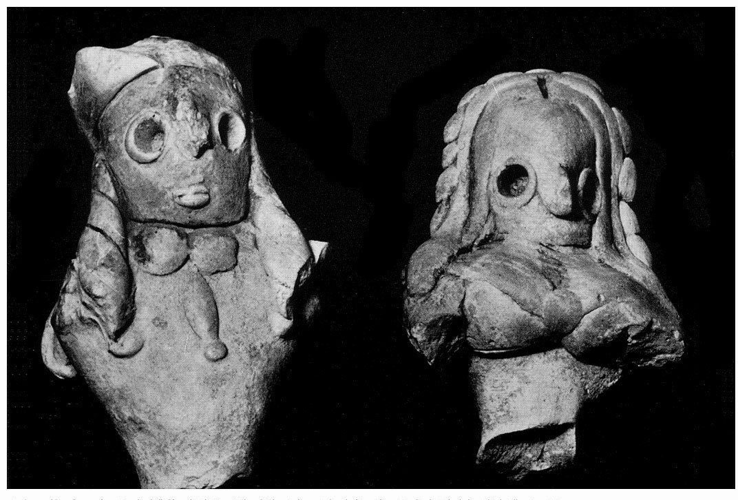
Mundigak
Mundigak (Pashto: منډیګک) is an archaeological site in Kandahar province in Afghanistan. During the Bronze Age, it was a center of the Helmand culture. It is situated approximately 55 km (34 mi) northwest of Kandahar near Shāh Maqsūd, on the upper drainage of the Kushk-i Nakhud River.
Mundigak was a large prehistoric town with an important cultural sequence from the 5th–2nd millennia BCE. It was excavated by the French scholar Jean Marie Casal in the 1950s. The mound was nine meters tall at the time of excavation.
Pottery and other artifacts form the later 3rd millennium BCE, when this site became a major urban center, indicate interaction with Turkmenistan, Baluchistan, and the Early Harappan Indus region.
Mundigak flourished during the culture of the Helmand Basin (Seistan), also known as the Helmand culture (Helmand Province).
With an area of 21 hectares (52 acres), this was the second largest centre of the Helmand Culture, the first being Shahr-i-Sokhta which was as large as 150 acres (60 hectares), by 2400 BCE.
Bampur in Iran is a closely related site.
Earlier, it was thought that around 2200 BCE, both Shahr-i-Sokhta and Mundigak started declining, with considerable shrinkage in area and with brief occupation at later dates.
During the French Archaeological Mission (MAI) excavations from 1951 to 1958 in ten campaigns under the direction of Jean Marie Casal with the support of the DAFA, different levels of settlement could be distinguished. The excavations took place in eleven places in the excavation area. On Tépé (hill) A, the highest point in the city, remains of a palace were excavated in Period IV, level 1 and Period V. Urban areas from almost all periods of the place were found here. Area C is northwest of Area A. Only a small area has been excavated here, with the remains reaching back to Period III. In the other parts of the city, various, larger or smaller areas were exposed (areas B, D to I and P and R), whereby mainly remnants of Period IV came to light, which is therefore the best documented layer. In area P, remnants of Period V came to light, which is otherwise only documented in area A. The upper layers in particular had completely disappeared as a result of erosion. In area A, a large palace was uncovered in Period V on the remains of the older palace. Otherwise, however, Period V is not easy to cover in the city. Most of the finds are now in the National Museum in Kabul and in the Museum Guimet in Paris. The excavator Jean Marie Casal had been employed in the latter museum since 1957.
Hub AI
Mundigak AI simulator
(@Mundigak_simulator)
Mundigak
Mundigak (Pashto: منډیګک) is an archaeological site in Kandahar province in Afghanistan. During the Bronze Age, it was a center of the Helmand culture. It is situated approximately 55 km (34 mi) northwest of Kandahar near Shāh Maqsūd, on the upper drainage of the Kushk-i Nakhud River.
Mundigak was a large prehistoric town with an important cultural sequence from the 5th–2nd millennia BCE. It was excavated by the French scholar Jean Marie Casal in the 1950s. The mound was nine meters tall at the time of excavation.
Pottery and other artifacts form the later 3rd millennium BCE, when this site became a major urban center, indicate interaction with Turkmenistan, Baluchistan, and the Early Harappan Indus region.
Mundigak flourished during the culture of the Helmand Basin (Seistan), also known as the Helmand culture (Helmand Province).
With an area of 21 hectares (52 acres), this was the second largest centre of the Helmand Culture, the first being Shahr-i-Sokhta which was as large as 150 acres (60 hectares), by 2400 BCE.
Bampur in Iran is a closely related site.
Earlier, it was thought that around 2200 BCE, both Shahr-i-Sokhta and Mundigak started declining, with considerable shrinkage in area and with brief occupation at later dates.
During the French Archaeological Mission (MAI) excavations from 1951 to 1958 in ten campaigns under the direction of Jean Marie Casal with the support of the DAFA, different levels of settlement could be distinguished. The excavations took place in eleven places in the excavation area. On Tépé (hill) A, the highest point in the city, remains of a palace were excavated in Period IV, level 1 and Period V. Urban areas from almost all periods of the place were found here. Area C is northwest of Area A. Only a small area has been excavated here, with the remains reaching back to Period III. In the other parts of the city, various, larger or smaller areas were exposed (areas B, D to I and P and R), whereby mainly remnants of Period IV came to light, which is therefore the best documented layer. In area P, remnants of Period V came to light, which is otherwise only documented in area A. The upper layers in particular had completely disappeared as a result of erosion. In area A, a large palace was uncovered in Period V on the remains of the older palace. Otherwise, however, Period V is not easy to cover in the city. Most of the finds are now in the National Museum in Kabul and in the Museum Guimet in Paris. The excavator Jean Marie Casal had been employed in the latter museum since 1957.