Hubbry Logo
MycaleMycaleMain
Open search
Mycale
Community hub
Mycale
logo
8 pages, 0 posts
0 subscribers
Be the first to start a discussion here.
Mycale
Mycale
from Wikipedia

Mycale (/ˈmɪkəli/) also Mykale and Mykali (Ancient Greek: Μυκάλη, Mykálē), called Samsun Dağı and Dilek Dağı (Dilek Peninsula) in modern Turkey, is a mountain on the west coast of central Anatolia in Turkey, north of the mouth of the Maeander and divided from the Greek island of Samos by the 1.6 km wide Mycale Strait. The mountain forms a ridge, terminating in what was known anciently as the Trogilium promontory (Ancient Greek Τρωγίλιον or Τρωγύλιον).[1] There are several beaches on the north shore ranging from sand to pebbles. The south flank is mainly escarpment.

Key Information

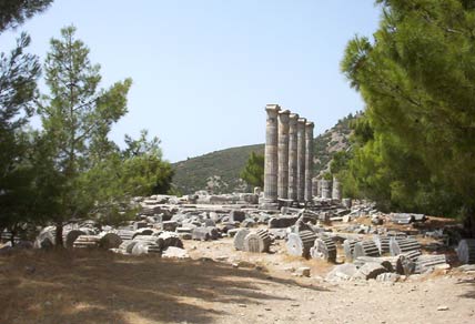
In classical Greece nearly the entire ridge was a promontory enclosed by the Aegean Sea. Geopolitically it was part of Ionia with Priene placed on the coast on the south flank of the mountain and Miletus on the coast opposite to the south across the deep embayment into which the Maeander River drained. Somewhat further north was Ephesus.

The ruins of the first two Ionian cities mentioned with their harbor facilities remain but today are several miles inland overlooking instead a rich agricultural plain and delta parkland created by deposition of sediments from the river, which continues to form the geological feature named after it, maeanders. The end of the former bay remains as a lake, Çamiçi Gölü (Lake Bafa). Samsun Daği, or Mycale, still has a promontory.

The entire ridge was designated as a national park in 1966; Dilek Yarimadisi Milli Parki ("Dilek Peninsula National Park") has 109.85 km2 (27,145 acres), which is partly accessible to the public. The remainder is a military reservation. The park's isolation has encouraged the return of the native ecology, which is 60% maquis shrubland. It is a refuge for species that used to be more abundant in the region.

Geophysics

[edit]
Mount Mycale seen from the island of Samos, across the Mycale Strait.

Western Turkey is mainly fault-block terrain, with steep-sided ridges running east–west and rivers in the rifts. The source of the faulting is the closing of Tethys Sea and the collision of the African and Arabian Plates with the Eurasian Plate. The smaller Turkish and Aegean plates are being pushed together, generating ridges in Turkey. This orogenic belt was in place by 1.6 mya and continues to be a hot spot of earthquakes and volcanoes.[2]

Mount Mycale is part of a larger ridge, which continues in Samos on the other side of the Samos Strait, and to the northeast in the Aydin Dağlari ("Aydin Mountains"), ancient Messogis range, on the other side of low hills and passes. The entire block of mountains around the Menderes (Maeander) River is known as the Menderes Massif.[3]

Mycale is scored transversely by numerous ravines through which sources drain. The biggest ravine is Oluk Gorge, with cliffs 200 m (656 ft) high. The main permanent streams are the Bal Deresi, the Sarap Dami and the Oluk Dereleri. The ample water supply supports a verdant maquis.

The rock is primarily metamorphic: marble and limestone formed from rocks originating in the Mesozoic, crystalline schists formed from rocks originating in the Palaeozoic and conglomerates of the Cenozoic. The renowned builders and sculptors of Ionia made full use of these materials for their major works.

Ecology

[edit]
Cypress in maquis

The ridge and its environs offer a number of different ecologies. The crest is a sharp divide between the xerophytic southern slopes and the forested northern slopes, with 66.24 km2 (16,368 acres) of maquis and 35.74 km2 (8,832 acres) of mixed pine.[4] Around the base of the promontory is a maritime environment.

The maquis vegetation includes Pistacia lentiscus; Laurus nobilis; Quercus ilex, Q. frainetto and Q. ithaburensis; Phillyrea latifolia; Ceratonia siliqua; Olea europaea; Rubus fruticosus; Myrtus communis; Smilax; Jasminum fruticans; Vitis vinifera; Lathyrus grandiflorus; Erica arborea, and Juncus on the slopes of the north. In moister areas are to be found Nerium oleander, Platanus orientalis, Fraxinus ornus, Laurus nobilis, Cupressus sempervirens and Rubus fruticosus.

The mixed pine forest goes up to 700 m (2,297 ft). Its major plant species are Pinus brutia, Juniperus phoenicea, with broad-leaved trees and shrubs: Ulmus campestris, Acer sempervirens, Fraxinus ornus, Castanea sativa, Tilia platyphyllos, Sorbus torminalis, Viburnum tinus, Pyrus eleagrifolia, and Prunus dulcis.

Some mammals native to the region are Sus scrofa, Vulpes vulpes, Hystrix cristata, Canis aureus, Canis lupus, Martes martes, Lynx lynx, Felis sylvestris, Ursus arctos, Meles meles, Lepus, Erinaceus europaeus, and Sciurus. Migrants are Caracal caracal and Panthera pardus.

Some birds are Columba livia, Alectoris graeca, Perdix perdix, Coturnix coturnix, Scolopax rusticola, Turdus merula, Turdus pilaris, Oriolus oriolus, Merops apiaster, eagles, vultures, Corvus corax, Pica pica, and Sturnus vulgaris.

Monachus monachus breeds in caves around the shores of Mycale. They and other marine predators (including man) feed on Planiliza, Pagellus, Dentex vulgaris and Thunnus thynnus.

History

[edit]
Map of Mycale, Lade, and Miletus.

Earliest references

[edit]

Mycale, Miletus and the Maeander appear in the Trojan Battle Order of the Iliad, where they are populated by Carians. "The steep heights of Mycale" and Miletus are also in the Hymn to Apollo, where Leto, pregnant with Apollo, an especially Ionian god, travels about the Aegean looking for a home for her son, and settles on Delos, the major Ionian political, religious and cultural center of Classical Greece.[citation needed]

A similar metaphor is to be found in the centuries-later Hymn to Delos of Callimachus, in which Delos, a swimming island, visits various places in the Aegean, including Parthenia, "Maiden's Isle" (Samos), where it is entertained by the nymphs of Mycalessos. Just as Parthenia is the previous name of Samos so the reader is to understand Mycalessos as the previous name of Mycale. On being chosen as the birthplace of Apollo, Delos becomes fixed in the sea.

In the Late Bronze Age, Mycale may have been known under the Hittite name Arrinnanda.[citation needed]

Hittite records of the Late Bronze Age. In Hitti language, Apasa (Ephesus), the capital of a state called Arzawa, in which also was Karkisha in (Caria) and Millawanda (Miletus). In the Linear B script tablets the region is called A-swi-ja (Asia). Documents at Pylos, Thebes and Knossos identify female textile workers and seamstresses (raptria) in servitude of Mi-ra-ti-ja, *Milātiai, "Milesians". The regions from which they came were centers of Mycenaean civilization although the languages they spoke was an early Greek-Mycenaean language and written in Linear B, although some support that was an unknown.[5]

The state of Melia

[edit]

After the Late Bronze Age the entire Aegean region entered a historical period termed the Greek Dark Ages. Archaeologically it was known as the Proto-geometric and Geometric Periods, which did not belong to any one ethnic group. This is the time to which heavy Ionic migration from mainland Greece to the coast of Ionia and the emergence of Delos as an Ionian center is believed to apply. These events were over at the start of the brilliant renaissance of the Orientalizing Period[citation needed] in which Ionia played a cardinal role.

During this rise to prominence twelve cities were settled or resettled and emerged as Ionia speaking varieties of Ionic Greek[citation needed]. Vitruvius, however, says there were thirteen, the extra state being Melite, which "... as a punishment of the arrogance of its citizens was detached from the other states in a war levied pursuant to the directions of a general council (communi consilio); and in its place ... the city of Smyrna was admitted into the number of Ionian states (inter Ionas est recepta)."[6] There is no other mention of Melite anywhere but two fragments of Hecataeus say that Melia was a city of Caria and an inscription from Priene confirms that there had been a "Meliac War"[7] against a state located between Priene and Samos; i.e., on Mycale.

The inscription records the result of an arbitration between Priene and Samos by jurors from Rhodes. Both litigants claimed that Carium, the fortified settlement of Melia, and Dryussa, another settlement, had been distributed to them at the conclusion of the Meliac War, when the Carians were expelled.[8] Being on the Samian side of the crest Melia had been resettled mainly by Samians and for this reason they had won a similar case brought before Lysimachus of Macedon a century earlier. That case is mentioned in an earlier inscription from Priene.[9]

Priene had now reopened the case arguing that their sale of plots from the land demonstrated their continuous ownership of it except for a brief period when an invasion of the Cimmerians under Lygdamis forced temporary Greek evacuation of the region (about 650 BC). The Samians used a passage from the now missing History of Maeandrius of Miletus to support their claim. The jury found that Maeandrius was not authentic and reversed the earlier decision.[10]

Panionium

[edit]

The Melians had named their capital Carium, "of Caria", as a Greek word[further explanation needed]. Considering that it was placed in Ionia, the choice of name suggests a political statement of some sort, although the word may have had a different meaning in the Carian language, now lost except for a few dozen words. The Ionians leagued together to defeat it and continued the league, building a capital they called Panionium, "of all the Ionians" next to the former Carium. It rose to prominence while the Ionian confederacy was sovereign, became a memory when Ionia was incorporated into other states and empires and finally was lost altogether. The ancient writers remembered that it had been on the north side of the mountain, across the ridge from Priene.

After a few false identifications in modern times, the ruins of Melia and the Panionium were discovered in 2004 on Dilek Daglari, a smaller peak of Mycale, 15 km (9 mi) to the north of Priene at an elevation of 750 m (2,461 ft).[11] The Carium must be the early 7th century BC town surrounded by a triangular wall in places as thick as 3 m (10 ft).

The floruit was the early 7th, but sherds have been found there from as early as the Protogeometric period. Coldstream characterizes the burial structures as of "a considerable Carian substrate".[12] The culture was not entirely Carian; the Ionians continued the worship of Poseidon Heliconius there, which Strabo says came from Helike in Peloponnesian Achaea.[13] This event must have been during the Ionian colonization. Melia therefore was a renegade Ionian state.

The temple believed to the Panionium was constructed next to the Carium about 540 BC.[11] It took over the worship of Poseidon Heliconius, served as the meeting place of the Ionian League, and was the site of the religious festival and games (panegyris) called the Panionia. The construction of this temple is a terminus post quem for the existence of the Ionian League, which as a constituted body had a name, the koinon Iōnōn ("common thing of the Ionians"), a synedrion ("place to sit down together") and a boulē ("council").

Whether this body existed before the Meliac War is uncertain. Vitruvius' commune consilium seems to translate koinon. Some analysts have postulated an association as early as 800 BC but whether formally constituted remains unknown. There is no sign of it yet on Mycale unless Carium had in fact been it.

Battle of Mycale

[edit]

In 479 BC, Mycale was the site of one of the two major battles that ended the second Persian invasion of Greece, during the Greco-Persian Wars. Under the leadership of the Spartan Leotychides, the Greek fleet defeated the Persian fleet and army.[14] According to Herodotus, the battle occurred the same day as the Greek victory at Plataea.[15]

Notes

[edit]

References

[edit]

Further reading

[edit]
[edit]
Revisions and contributorsEdit on WikipediaRead on Wikipedia
from Grokipedia
Mycale is a and mountain range located on the western coast of Asia Minor in present-day , opposite the island of and separated by the narrow Mycale Strait, best known as the site of a pivotal naval and land battle in August 479 BCE during the , where allied Greek forces decisively defeated the Persian navy and army, marking the effective end of the Persian invasion of Greece. Geographically, Mount Mycale, now known as the Dilek Peninsula and part of Dilek Peninsula-Büyük Menderes Delta National Park, forms a prominent ridge in southwestern , rising to an elevation of 1,237 meters (4,058 feet) and extending southwest of the modern town of Atburgazı, near of , with its rugged terrain playing a key role in historical military maneuvers. The occurred shortly after the Greek victory at , as the Spartan king Leotychides II commanded a fleet of 110 ships carrying Athenian hoplites and Spartan warriors, while the Athenian Xanthippus led the ; the , under generals Tigranes and Mardontes, had beached their remaining fleet of around 300 ships and fortified their position with 60,000 troops on the promontory's slopes. The Greeks landed unopposed, delivered a speech to encourage Ionian allies like the Samians and Milesians to defect, and launched a coordinated : Athenian forces engaged the head-on along the , drawing them into open combat, while Spartans executed a over the hills to cut off retreat, leading to the destruction of the Persian camp, fleet, and a significant portion of their army, with heavy casualties on both sides including the deaths of Tigranes, Mardontes, and the Greek general Perilaus. This victory, the first major Greek success on Asian soil, crippled Persian naval power in the Aegean, liberated Ionian Greek cities from immediate Persian control, and shifted the strategic initiative to the , ushering in a period of dominance and preventing further large-scale Persian incursions into Europe for decades.

Geography

Location and Extent

Mount Mycale, known today as Dilek Dağı or Samsun Dağı, forms a prominent range within the Aydın Mountains in the Aegean region of western . This mountain is integral to the landscape of ancient , extending along the coast of what is now . The range's position marks the northern boundary of the Dilek Peninsula, jutting into the and influencing regional maritime geography. The highest point of Mount Mycale, Dilek Tepesi, rises to 1,237 meters above sea level, with the range averaging around 600 meters in elevation. Centered approximately at 37°40′N 27°09′E, the mountain covers roughly 109.85 km², constituting the core of the Dilek Peninsula within the larger Dilek Peninsula-Büyük Menderes Delta National Park, which spans a total of 276.75 km² including the adjacent . This area delineates the peninsula's boundaries from the Aegean coastline eastward to the delta's wetlands. Mount Mycale lies in close proximity to the Greek island of , separated by the narrow , which measures about 1.6 km at its narrowest point. The encompassing the mountain is situated between the modern town of to the north and to the northeast, with the delta extending the protected zone southward and enhancing the overall geographical extent.

Topography and Landforms

Mycale exhibits a classic fault-block structure, a product of the prevalent in western , where normal faulting has uplifted blocks of crust to form prominent ridges. The western slopes are notably steep and rugged, dropping sharply to the and creating dramatic coastal cliffs that enhance the peninsula's isolation and scenic appeal. In contrast, the eastern slopes are more gradual, facilitating a smoother transition to the adjacent Büyük Menderes plain and allowing for broader alluvial deposits at the base. The overall form of Mycale defines the Dilek Peninsula, a protruding landmass extending approximately 20 km westward into the from the Anatolian mainland, connected by a narrow that measures just a few kilometers wide. The mountain range itself spans about 25 km in a north-south orientation and about 10 km in width, with elevations rising progressively from the coastal lowlands to interior peaks. The highest summit, Dilek Tepe (also known as Samsun Tepe), reaches 1,237 meters above , offering panoramic views across the strait to the island of and exemplifying the range's fault-controlled relief. Prominent landforms include the Oluk Gorge, a deep ravine carved through the central range that showcases vertical cliffs and exposes the underlying geological layers, alongside various karstic caves formed by dissolution in the terrains, such as the Cave near the southern slopes. Along the western coast, sheltered coves like Kavaklı Burun and Karasu provide pebbly beaches and clear waters, serving as natural harbors amid the otherwise precipitous shoreline. These features contribute to Mycale's diverse microtopography, from incised valleys to pocket bays. Hydrologically, Mycale is drained by several seasonal streams that originate from the high plateaus and flow intermittently westward to the Aegean or eastward toward the system, with flow rates varying markedly between wet winters and dry summers. At the eastern foothills, these streams interact with the expansive wetlands of the Büyük Menderes Delta, a low-lying of marshes and lagoons that buffers the mountain base and supports sediment deposition. This seasonal variability underscores the Mediterranean climate's influence on the region's water dynamics.

Geology

Tectonic Formation

The Menderes Massif, of which Mycale forms the westernmost extension on the Dilek Peninsula, is situated within the Aegean extensional province of western Anatolia and originated from the convergence and collision between the African and plates during the Eocene phase of the , with subsequent extensional intensifying in the epoch. This collisional phase involved the northward of African lithosphere beneath , leading to crustal thickening and metamorphic overprinting across the Anatolide , including the stacking of systems in the Menderes region. Subsequent to the main collisional compression, the massif underwent significant uplift driven by normal faulting associated with Miocene back-arc extension in the Aegean domain, occurring primarily over the last 5–10 million years and resulting in the exhumation of deep-seated rocks from depths of up to 20 km. This extensional regime produced the characteristic horst-graben system prevalent in western Anatolia, with bivergent low-angle detachment faults—such as the Kuzey and Güney detachments—facilitating the rapid unroofing of the core complex. The tectonic evolution is further modulated by the Aegean extensional faults, which dominate the regional strain, alongside indirect influences from the strike-slip North Anatolian Fault to the north, contributing to the overall westward escape of the Anatolian plate. This faulting has exposed basement rocks ranging from Precambrian gneisses of Pan-African affinity (ca. 520–550 Ma) to Paleozoic metasediments, including micaschists and metaquartzites, particularly evident in the northern and central sectors of the massif extending toward Mycale. Mycale resides in a moderate seismic risk zone characteristic of the active Aegean extensional province, where ongoing normal faulting accommodates north-south extension rates of 15–20 mm/year. Historical earthquakes, including several moderate to strong events (M 5.5–6.0) in the near Island adjacent to Mycale and more recent activity like the 2020 M 7.0 Samos earthquake, have contributed to the incision of transverse gorges across the mountain's slopes through coseismic surface rupturing and enhanced erosion. This underscores the dynamic nature of the horst-graben terrain, with fault-block uplift patterns visible in the surrounding topography.

Rock Types and Structures

The geology of Mount Mycale, located in the Dilek Peninsula of western Turkey, is characterized by a predominance of metamorphic rocks, including marbles derived from limestones, various s (such as muscovite-quartz , muscovite-albite-biotite-quartz , and muscovite-garnet-chlorite ) formed from protoliths, and gneissose s. Phyllites and minor metavolcanic rocks, including metabasites and metaultramafics, are also present, representing altered igneous materials from volcanic arcs. These metamorphic assemblages reflect high-pressure/low-temperature conditions associated with processes in the region. Stratigraphically, the sequence begins with a basement consisting of schists and marbles in the Efes Nappe (Late Paleozoic–Early Triassic), overlain by metacarbonates and cherty marbles in the Dipburun Nappe (–Late ), which exhibit features due to the of these rocks. Tertiary sediments, including the Late –Early Tertiary İzmir Flysch with clastics, radiolarites, and limestone blocks, unconformably overlie these units, followed by Early Miocene to Quaternary deposits. The metacarbonates, particularly the marbles, have been historically exploited in antiquity for construction, as evidenced by nearby ancient sites like Priene. Structurally, the rock layers are intensely folded and faulted, with thrust contacts between such as the Dipburun, Efes, and Şirince Metaflysch units, forming a stacked nappe sequence. Synclinal structures, like that at Boncuk Dağı in the Şirince Metaflysch (over 1000 m thick), indicate compressional deformation, while later vertical and oblique faults reflect Miocene–Quaternary Unique formations include remnants in the Şirince Metaflysch, comprising metaultrabasics, eclogites, and amphibolites embedded in a pelitic schist matrix, signifying ancient seafloor exposure during obduction. Tectonic uplift has exposed this diverse assemblage at the surface.

Ecology

Flora and Vegetation

Mycale's flora thrives in a Mediterranean climate characterized by mild, wet winters and hot, dry summers, fostering a rich diversity of plant communities across its varied topography. The region hosts approximately 804 vascular plant species, including 6 taxa endemic to the park and 18 endemic to , contributing significantly to the country's botanical heritage. This diversity is shaped by the interplay of coastal influences, elevation gradients, and periodic disturbances like wildfires, which favor resilient, adaptive species. The dominant vegetation type is maquis shrubland, a dense, evergreen sclerophyllous community typical of the Mediterranean basin, featuring low trees and shrubs such as Quercus coccifera (kermes oak), Pistacia lentiscus (mastic tree), and Ceratonia siliqua (carob). Recent surveys have identified distinct associations within this shrubland, including Urgino-Quercetum cocciferae (with Urginea maritima and Quercus coccifera) and Pistacio-Ceratonietum siliquae (with Pistacia lentiscus and Ceratonia siliqua), alongside aromatic herbs like thyme (Thymus spp.) and sage (Salvia spp.) that add ecological and olfactory richness. These formations cover large portions of the peninsula's slopes and coastal areas, providing habitat stability in nutrient-poor, rocky soils. Higher elevations and north-facing slopes support pine forests dominated by Pinus brutia (Turkish pine), a fire-adapted species that regenerates vigorously from serotinous cones following wildfires, ensuring rapid ecosystem recovery. Interspersed in sheltered valleys are mixed deciduous woodlands, including Platanus orientalis (oriental plane tree) and other riparian species that benefit from seasonal moisture. These forests contrast with the shrublands, offering cooler microclimates and supporting herbs. The Büyük Menderes Delta wetlands represent a distinct zone of hygrophilous and halophytic vegetation, with extensive reed beds of Phragmites australis forming dense stands that stabilize sediments and filter water. Halophytes such as Salicornia spp. and Limonium spp. dominate saline fringes, adapted to fluctuating brackish conditions. Notable endemics in these transitional habitats include Campanula tomentosa, a perennial herb restricted to coastal dunes and scrub edges. Seasonal dynamics enhance the region's botanical spectacle: spring brings a profusion of geophytes and annuals, including orchid species (e.g., Ophrys spp.) and Cyclamen spp., carpeting clearings in vibrant displays before summer drought induces dormancy. Post-wildfire landscapes reveal fire-adapted pioneers like Pinus brutia seedlings and resprouting maquis shrubs, underscoring the ecosystem's resilience to natural disturbances. This flora is safeguarded through the area's designation, which limits human impacts to preserve these communities.

Fauna and Biodiversity

The fauna of Mycale, encompassing the Dilek Peninsula and adjacent Büyük Menderes Delta, supports a rich array of animal life adapted to its Mediterranean coastal, forested, and wetland environments. This biodiversity underscores the region's ecological value, with diverse habitats fostering complex interactions among species, including predation, foraging, and migration patterns. The area's varied topography—from rugged mountains to sandy beaches and reed-fringed deltas—enables coexistence of terrestrial, avian, and marine taxa, though ongoing pressures like habitat fragmentation pose risks to population viability. Among mammals, wild boar (Sus scrofa) are commonly observed, roaming woodlands and coastal fringes where they root for food and occasionally venture near human areas, contributing to seed dispersal and soil aeration in the ecosystem. Fallow deer (Dama dama) also inhabit the area, adding to the ungulate diversity. The endangered Mediterranean monk seal (Monachus monachus) utilizes coastal caves along the peninsula for pupping and resting, representing a critical remnant habitat for this critically endangered pinniped, which faces threats from marine disturbances. These mammals highlight the interconnected food webs, with boars serving as prey for larger carnivores and seals relying on fish stocks influenced by delta nutrient flows. The avian community is particularly diverse, with over 250 species recorded, many utilizing the delta wetlands as a vital stopover on the East Atlantic Flyway for seasonal migrations between Europe and Africa. The Dalmatian pelican (Pelecanus crispus), a near-threatened species, breeds in the Büyük Menderes Delta, where colonies benefit from abundant fish prey in shallow lagoons. Raptors such as eagles (Hieraaetus pennatus and Aquila spp.) and migratory falcons patrol the skies, preying on rodents and birds, while the delta's reedbeds host herons and waders during wintering periods. This ornithological richness supports ecosystem services like and with the pelican's behavior aerating sediments and enhancing wetland productivity. Reptiles and amphibians thrive in the peninsula's mosaic of habitats, with the loggerhead turtle (Caretta caretta) nesting on select beaches during summer, though in low numbers compared to major Turkish sites; females emerge at night to lay clutches in sandy zones protected by dunes. Vipers inhabit rocky outcrops and maquis shrublands, ambushing small vertebrates and contributing to rodent population regulation. Endemic frogs, such as populations of Pelophylax spp. adapted to local wetlands, breed in temporary ponds, their calls echoing during spring choruses and aiding in insect control. These herpetofauna exemplify the region's microhabitat specialization, where seasonal water availability drives reproductive cycles and dispersal. Approximately 42 reptile and 10-15 amphibian species are present. Invertebrate diversity bolsters the food base for higher trophic levels, featuring a variety of that pollinate flowering plants amid the forests and meadows. Endemic snails, such as Bythinella turca in spring-fed habitats, exhibit specialized shell morphologies suited to damp, limestone crevices, playing roles in detritus decomposition and calcium cycling. Overall, the area harbors over 350 vertebrate species across mammals (28), birds (250), reptiles (42), amphibians (10-15), and fish (45), with habitat fragmentation from coastal development exacerbating isolation of populations and increasing vulnerability to stochastic events. The diverse vegetation of maquis, pine woodlands, and delta reeds provides essential cover and foraging grounds, sustaining these faunal assemblages.

History

Earliest References

The earliest potential reference to the region of appears in Hittite texts dating to approximately 1400 BC, during the reign of King Muršili II (ca. 1321–1295 BC). In the annals detailing campaigns against the kingdom of in western Anatolia, the toponym "Arinnanda" is described as a steep, wooded mountain protruding into the sea, serving as a refuge for Arzawan forces and their allies. Traditional scholarship identifies Arinnanda with Mount Mycale based on its topographical features and location near Miletus, suggesting Bronze Age awareness of the area's strategic prominence, though recent analyses propose alternative sites in the Knidian peninsula of due to inconsistencies in distances and regional toponyms. In Greek literary tradition, Mycale is first attested in Homer's Iliad (Book 2, line 868), composed around the 8th century BC but evoking Bronze Age settings. Within the Catalogue of Trojan Allies, the "steep crests of Mycale" are listed alongside and the Maeander River as territories inhabited by Carian speakers, non-Greek allies of Troy. This reference links the mountain to early Anatolian populations and implies its cultural significance in Mycenaean-era narratives, possibly reflecting oral traditions of Ionian tribal connections that predate the poem's redaction. Archaeological findings indicate Mycenaean trade or settlement in the region during the Late Helladic III period (ca. 1400–1200 BC), bridging to the subsequent Ionian migration around the 11th century BC, when Greek colonists from the mainland established Ionian poleis along the coast, associating Mycale with emerging Ionian identity. Its protruding position into the Aegean aided such early maritime interactions. The name "Mycale" (Ancient Greek: Μυκάλη) likely derives from a pre-Greek Anatolian substrate language, with no definitive established; possible links to local goddess worship, such as cults of Hera or Demeter attested in nearby sanctuaries, suggest a religious connotation, while folk interpretations occasionally connect it to terms evoking "mule" (μύλος or related forms), symbolizing hybridity or terrain, though these remain speculative.

Meliac War and State of Melia

The State of Melia was a pre-Ionian settlement located on the northern slopes of Mount Mycale in ancient , possibly originating from Carian or Lelegian populations, though some traditions link it to Theban colonists from Colophon. Centered around a fortified town known as Melie, it controlled significant territory on the cape, functioning as an independent polity with Greek and indigenous influences before the arrival of Ionian migrants from mainland Greece. Herodotus provides contextual details on the early Ionian settlements in the region, listing twelve cities and noting the sanctuary at Mycale as a unifying site, implying Melia's role in the broader landscape prior to Ionian dominance. The Meliac War, dated to around 650 BC or earlier in the mid-7th century BC, arose from tensions between the indigenous Melians and invading Ionian settlers, who viewed Melia's independence and Carian alliances as a threat to their expansion. According to Hellenistic inscriptions and Roman accounts, the twelve Ionian cities, acting in concert as an early league, declared war on Melia for its "arrogance" and successfully besieged and destroyed the fortified town, marking a pivotal moment in Ionian consolidation. This conflict, possibly triggered by disputes over land and resources near the Maeander River mouth, represented one of the earliest instances of collective Ionian military action against local powers. In the aftermath, Melia's territory was divided among the victorious Ionian cities, primarily Miletus, Priene, Colophon, and Samos, facilitating the expansion of their hinterlands and the establishment of the Panionion sanctuary on the site's ruins. The destruction ended Melia's autonomy, integrating its lands into the Ionian framework and symbolizing the transition from fragmented settlements to a more unified regional identity. Archaeological evidence supports this narrative, with the site's identification near modern Özdere in Turkey revealing ruins of defensive walls and a necropolis that ceased use around 700–650 BC, confirmed by 19th-century surveys led by Theodor Wiegand and later excavations in the mid-20th century.

Panionium and Ionian League

The Panionium, established around 540 BC on the northern slopes of Mount , served as the central religious and political sanctuary for the Ionian League, a confederation of twelve Ionian city-states including Miletus, Priene, and Ephesus. This site was dedicated to Poseidon Heliconius, reflecting the Ionians' shared cultural and ethnic identity following their victory in the Meliac War, which granted them control over the former territory of the Carian city-state of Melia. The sanctuary's construction on this location symbolized the league's consolidation of power and unity in the face of external pressures, including emerging threats from Lydian and later Persian expansion. Architecturally, the Panionium featured a terraced complex with a temple of the Ionic order, altars for communal sacrifices, and areas for assembly, dating to the mid-sixth century BC based on pottery and structural remains. Excavations led by German archaeologist Hans Lohmann from 2001 to 2007 at Çatallar Tepe confirmed its identification as the Panionium, uncovering over 500 architectural fragments, inscriptions honoring , and Archaic pottery that attest to its role as a pan-Ionian gathering place. These findings revealed a monumental altar and terrace system designed to accommodate large crowds, emphasizing the site's function beyond mere worship to include diplomatic deliberations among the league's members. The sanctuary hosted the annual Panionia festival, during which representatives from the twelve cities convened for sacrifices, athletic contests, and political discussions, fostering a sense of collective Ionian identity through the ritual offering of a hecatomb to Poseidon Heliconius. This event, described by as a key institution of Ionian unity, allowed the league to coordinate responses to regional challenges and reinforced cultural ties in the Archaic period. Strabo later noted its continued significance into the Hellenistic era, though its primary prominence waned after the Persian reconquest of Ionia around 494 BC, which led to the abandonment of the site as a league center.

Battle of Mycale

The Battle of Mycale occurred in 479 BC as the culminating naval engagement of the second Persian invasion of Greece, following the Greek victory at Salamis the previous year. The allied Greek fleet, commanded by the Spartan king Leotychides II and the Athenian general Xanthippus, pursued the retreating Persian navy under Artayntes and Ithamitres across the Aegean Sea toward Ionia. Encouraged by favorable omens and intelligence from Samian envoys promising Ionian defection, the Greeks sailed from Delos to Samos and then landed on the coast near Mount Mycale, coinciding with the land victory at Plataea on the same day. The Persian forces, numbering approximately 60,000 under generals Tigranes and Mardontes, had beached their remaining 300 ships—many of which were unseaworthy Phoenician vessels—and fortified a camp with a palisade and ditch on the wooded slopes of Mycale to avoid a naval confrontation. The Greeks disembarked around 40,000 hoplites from their fleet of about 110 triremes, primarily Peloponnesian with Athenian support, and advanced on the Persian position after Leotychides rallied the troops with a proclamation of the Plataea triumph. Samians and other Ionians within the Persian ranks began to waver, with some secretly sabotaging defenses. The battle commenced with the Greeks storming the beach to set fire to the beached Persian ships, disrupting the enemy camp and forcing a land engagement in the dense, uneven terrain of the mountainside. Athenian forces led a , while Spartans executed a flanking maneuver along the higher ground, exploiting the wooded landscape to outmaneuver the Persians' heavier infantry. The Persians initially held firm behind their fortifications, but Ionian defections—particularly by Milesians who attacked from the rear—shattered their lines, leading to a rout amid the trees and rocks. Greek forces pursued the fleeing Persians inland, slaying Tigranes and Mardontes, and sacked the Persian camp, located near the Panionion sanctuary. Herodotus reports around 40,000 Persian casualties, while Diodorus Siculus estimates over 40,000 killed, including significant losses among the Ionian contingents; Greek losses were minimal, with only a few dozen hoplites slain. This decisive victory liberated the Ionian Greek cities from Persian control, ending the immediate threat of the through synchronized triumphs at Mycale and Modern analyses highlight the tactical exploitation of Mycale's terrain for flanking and the rare unity among Greek city-states, including prior Ionian League members, as pivotal to the outcome.

Modern Significance

National Park Designation

The Dilek Peninsula-Büyük Menderes Delta National Park was established on May 19, 1966, initially covering 10,985 hectares of the Dilek Peninsula, marking one of Turkey's early protected areas under the National Parks Law No. 2873. It was expanded on July 8, 1994, to incorporate the adjacent Büyük Menderes Delta, adding 16,613 hectares and bringing the total protected area to 27,598 hectares. The park is administered by the General Directorate of Nature Conservation and National Parks within the Ministry of Agriculture and Forestry, with a Long-Term Development Plan approved in 1997 and revisions initiated in 2018 to guide sustainable management. The designation aimed to preserve the region's unique geological features, such as karst formations and coastal ecosystems, alongside its rich biodiversity encompassing maquis shrublands, wetlands, and diverse flora and fauna. Protection also extends to cultural heritage, including ancient sites like the Cave of Zeus and remnants linked to historical events on the peninsula. The park's boundaries fully encompass the Dilek Peninsula and the Büyük Menderes Delta, spanning from the Aegean coastline inland to the river's outflow. Internally, it features zoning to balance conservation and human use, including a Sensitive Protected Zone for strict ecological safeguarding, a Sustainable Utilization Zone for controlled resource activities, and a Regulated Zone for recreational purposes. This national park emerged amid Turkey's post-World War II conservation efforts, which gained momentum with the establishment of the country's first national park in 1958, reflecting a broader global trend toward environmental protection in the mid-20th century. No major boundary changes have occurred since the 1994 expansion, according to records up to 2019.

Conservation and Tourism

Conservation efforts in the Dilek Peninsula-Büyük Menderes Delta National Park focus on mitigating environmental degradation through targeted initiatives. Following widespread wildfires in Turkey during the summer of 2021, which affected forested areas near the park, the Ministry of Agriculture and Forestry launched extensive reforestation programs, planting millions of saplings nationwide to restore burned landscapes, including regions adjacent to the national park. These efforts aim to rehabilitate maquis shrublands and pine forests that are vital to the park's ecosystem. Additionally, organizations like the Turkish Marine Research Foundation (TUDAV) and the Marine Mammal Conservation Group (SAD-AFAG) conduct anti-poaching patrols and habitat monitoring to protect endangered species such as the Mediterranean monk seal (Monachus monachus), which has been sighted in the park's coastal caves, and loggerhead turtles (Caretta caretta), which nest along the delta beaches. The park faces several ongoing threats that challenge these conservation measures. Urban encroachment from nearby Kuşadası has led to habitat fragmentation and increased pressure on natural areas, with unplanned development posing risks to ecological integrity. Tourism-related pollution, including litter from visitors on beaches like those in İçmeler Bay, contributes to aesthetic degradation and marine debris accumulation, affecting coastal biodiversity. Climate change exacerbates these issues by altering salinity levels in the Büyük Menderes Delta, as seen in nearby Bafa Lake where rising evaporation and reduced freshwater inflow have increased salt concentrations, threatening wetland habitats. No significant new archaeological discoveries have been reported in the park between 2018 and 2025, allowing focus to remain on environmental protection rather than excavation-related disturbances. Tourism in the park emphasizes sustainable access to its natural features, with well-maintained hiking trails ranging from 4 to 6 hours, such as the 10 km path through forested canyons leading to ancient sites like the Panionium ruins. Pristine coves and sandy beaches provide opportunities for swimming and picnicking, drawing hundreds of thousands of domestic and international visitors annually, whose entry fees—around 23 Turkish lira per person as of 2024—fund park maintenance and conservation activities. Post-2021 wildfire recovery has included enhancements to trails for improved fire safety, such as wider paths and signage to reduce ignition risks from human activity. Ecotourism initiatives promote the park's rich biodiversity, including protected fauna like monk seals and turtles, encouraging low-impact visitation to support long-term habitat preservation without detailing recent species discoveries.

References

Add your contribution
Related Hubs
User Avatar
No comments yet.