
Community hub
Recent from talks
Contribute something
Nothing was collected or created yet.
Strait of Messina
View on Wikipedia
You can help expand this article with text translated from the corresponding article in Italian. (February 2018) Click [show] for important translation instructions.
|
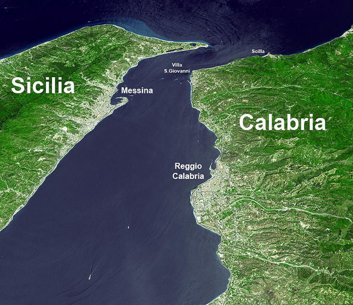
The Strait of Messina[1] is a narrow strait between the eastern tip of Sicily (Punta del Faro) and the western tip of Calabria (Punta Pezzo) in Southern Italy. It connects the Tyrrhenian Sea to the north with the Ionian Sea to the south, within the central Mediterranean. At its narrowest point, between Torre Faro and Villa San Giovanni, it is 3.1 km (1.9 mi) wide. At the city of Messina, it is 5.1 km (3.2 mi) wide. The strait's maximum depth is about 250 m (820 ft).
Key Information


The strait has strong tidal currents that create a unique marine ecosystem.[2] The rock in the town of Scilla, Calabria at the north of the strait and a natural whirlpool in the northern portion of the strait have been linked to the Greek legend of Scylla and Charybdis.[3] In some circumstances, the mirage of Fata Morgana can be observed when looking at Sicily from Calabria. With its bottleneck shape, it is also a compulsory point of transit in the migration of many bird species.
Bird migration
[edit]
The Strait of Messina is a focal point in the migrations of birds every year, who mainly cross the strait to reach their breeding grounds in northern Europe. Due to this form of bottleneck more than 300 species are recorded in the area, which is a major European hot spot for raptors, with a record of 35,000 in one spring.[4]
Among them the European honey buzzard and the marsh harrier are the most frequent, and species like Bonelli's eagle and Egyptian vulture are less frequent but regular. In the coastal salt lakes of the Strait of Messina species like glossy ibis, flamingos and black-winged stilt stop to rest. The site is also favorable for observing storks. The Monte Dinnammare and the other Peloritani mountains overlooking the Strait are a natural theatre for birdwatching.
Marine life
[edit]Due to its unique hydrogeological conditions[further explanation needed] the Strait of Messina has high levels of biodiversity and multiple endemic species. In its waters there is a strong presence of deep sea fish like the Sloane's viperfish which, due to the particular and peculiar currents of the strait, are occasionally found stranded on the shore at sunrise. The strait is also an important point of migration of many species of fish in the Mediterranean Sea.
Transportation
[edit]
A ferry service connects Messina on Sicily with the mainland at Villa San Giovanni, which lies several kilometers north of the large city of Reggio Calabria; the ferries hold the cars (carriages) of the mainline train service between Palermo and Naples. There is also a hydrofoil service between Messina and Reggio Calabria.
Bridge plans
[edit]For decades, the possibility of building a bridge across the Messina Strait has been under discussion. In 2006, under Prime Minister Romano Prodi the project was cancelled.[5] In 2009, as part of a massive new public works program, Silvio Berlusconi's government announced that plans to construct the Strait of Messina Bridge had been fully revived, pledging €1.3 billion as a contribution to its estimated cost of €6.1 billion[6] Some 3.3 km long and 60 m wide, the bridge would be supported by two 382 m pillars, each higher than the Empire State Building, and accommodate six freeway lanes, a railway (for up to 200 trains a day), and two walkways.
Supporters perceive the bridge as an opportunity for job creation and potential for an increase in tourism to the island. Opponents see it as an ecological disaster, a structure at risk due to especially strong winds and earthquakes (the area having an intense seismic record), and a potential increase in Sicilian and Calabrian organized crime. Berlusconi claimed in 2009 that work would be completed by 2016, although in February 2013, the project was cancelled again.[7]
Italian prime minister Giorgia Meloni revived the project with a decree in 2022. The government gave it final approval in August of 2025. Construction is set to start in 2025 and to be completed by 2032.[8][9] Opponents of the project cited an estimate that of the 4.3 million birds that fly through the strait annually, 17–46% risked colliding with the proposed bridge.[10]

Pylons
[edit]In 1957, a 220 kV overhead power line was built across the Strait of Messina. Its pylons are among the highest in the world. This power line has since been replaced by a submarine power cable, but the pylons remain and are protected as historical monuments (see Pylons of Messina).
On July 10, 2024, Estonian athlete Jaan Roose crossed the Strait of Messina on a slackline spanned between the two Messina pylons. He surpassed the previous longest slackline walk of 2,710 meters and completed a distance of 3,600 meters.[11]
See also
[edit]References
[edit]- ^ (Italian: Stretto di Messina; Sicilian: Strittu di Missina)
- ^ Archived at Ghostarchive and the Wayback Machine: TheSanti63 (25 August 2010), Correnti nello Stretto di Messina
{{citation}}: CS1 maint: numeric names: authors list (link) - ^ Andrews, Tamra (2000). Dictionary of Nature Myths: Legends of the Earth, Sea, and Sky. Oxford University Press. p. 171. ISBN 978-0-19-513677-7. Retrieved 25 May 2016.
- ^ Corso, Andrea. "European Birding Hot Spot: The Strait of Messina, southern Italy". www.surfbirds.com.
- ^ "Italy drops Sicily bridge plans". BBC News. 12 October 2006.
- ^ Italy revives Sicily bridge plan from BBC News. Retrieved 8 March 2009.
- ^ Sicily to get longest bridge from TimesOnline. Retrieved 8 March 2009.
- ^ "Italy gives final go-ahead for landmark Sicily bridge project". reuters.com. 6 August 2025. Retrieved 6 August 2025.
- ^ "World's longest suspension bridge to be built over earthquake fault line". Newsweek. 4 May 2025. Retrieved 2 June 2025.
- ^ "Is history repeating as Italy resurrects Messina bridge plan?". euronews. 14 April 2023. Retrieved 7 July 2023.
- ^ "Jaan Roose attempts Messina Strait - on a slackline!". Red Bull. 10 July 2024. Retrieved 10 July 2024.
Further reading
[edit]- Fabio Spadi (2001) "The Bridge on the Strait of Messina: 'Lowering' the Right of Innocent Passage?" International and Comparative Law Quarterly 50: 411 ff.
- "From Rome to Sicily: Plane or Train?" Expert Travel Advice, The New York Times, Feb. 7, 2008 The New York Times.
| History of Messina | |||||||||||||||
|---|---|---|---|---|---|---|---|---|---|---|---|---|---|---|---|
| Monuments and places | |||||||||||||||
| Personalities |
| ||||||||||||||
| Parks & nature reserves | |||||||||||||||
| Sport events | |||||||||||||||
| Transportation & infrastructure | |||||||||||||||
Strait of Messina
View on GrokipediaGeography and Physical Characteristics
Location and Dimensions
The Strait of Messina lies in the central Mediterranean Sea, separating the eastern coast of Sicily from the Calabrian Peninsula on the Italian mainland. It serves as the passage linking the Tyrrhenian Sea to the north with the Ionian Sea to the south, forming a vital navigational corridor between these two basins. The strait's approximate central coordinates are 38°10′N 15°40′E, with the northern extent near the Aeolian Islands archipelago.[1][5] Measuring about 32 kilometers in length, the strait narrows progressively northward, reaching its minimum width of 3.1 kilometers between Torre Faro (also known as Punta del Faro) on Sicily and Villa San Giovanni (near Punta Pezzo) on Calabria. Widths increase southward to around 16 kilometers, while depths vary from shallow sills of about 70 meters to a maximum of approximately 250 meters.[5][1][6]Geological Formation and Seismic Activity
The Strait of Messina lies within the Calabrian Arc, a narrow segment of the convergent plate boundary where the African plate subducts beneath the Eurasian plate, specifically involving the rollback of the Ionian oceanic slab. This subduction process, ongoing since the Miocene, has induced back-arc extension in the overriding Tyrrhenian plate, leading to rifting and the development of the strait's graben-like structure through Quaternary normal faulting and block uplift of the Calabria-Peloritani terrane.[7][8] The resulting morphology features depths exceeding 200 meters in the central sill, flanked by shallower shelves, with extensional tectonics accommodating differential uplift rates of up to 1-2 mm/year in Calabria relative to Sicily.[9] Seismic activity in the strait arises from the complex interplay of compressional subduction forces, strike-slip transfer faults, and extensional rifting at the arc's southeastern termination, where the Calabrian domain transitions to the compressional Sicilian fold-and-thrust belt. Key fault systems include the NE-SW trending Tindari-Letojanni fault (dextral strike-slip) and NNW-SSE normal faults like the Messina Strait fault, capable of magnitudes up to Mw 7, with slip rates estimated at 1-2 mm/year based on geodetic data.[10][11] Volcanic influences from the adjacent Aeolian arc and Mount Etna manifest indirectly through slab tear propagation and asthenospheric upwelling, which modulate regional stress fields and facilitate fault reactivation, though no active volcanism occurs within the strait itself.[12][13] Historical seismicity underscores the area's hazard, with the 1783 Calabria seismic crisis comprising five major events (magnitudes ~6.5-7.0) from February to March that triggered widespread landslides and tsunamis, followed by the December 28, 1908, Messina earthquake (Mw 7.1), sourced on a blind normal fault beneath the strait and causing ~80,000 deaths through shaking, liquefaction, and 10-12 m tsunamis.[14][15][16] The Istituto Nazionale di Geofisica e Vulcanologia (INGV) seismic network records persistent microseismicity (hundreds of events annually, mostly M<3.0) and occasional swarms, indicating strain accumulation along unmapped offshore faults, with GPS data showing ongoing extension at ~5 mm/year across the strait.[17][18]Hydrological Features and Currents
The Strait of Messina is characterized by intense bidirectional tidal currents driven by the approximately 180-degree phase opposition of semi-diurnal tides between its Tyrrhenian (northern) and Ionian (southern) boundaries, resulting in alternating flows every six hours along the strait's axis.[19] These currents arise from the co-oscillation of Mediterranean sea levels, where density gradients between relatively fresher surface waters and saltier intermediate waters from the eastern Mediterranean exacerbate vertical mixing, though the primary forcing is tidal.[20] Peak velocities during spring tides reach 1.8 to over 3 m/s (3.5–6 knots), concentrated in the narrow central sill where bathymetric constrictions amplify shear.[21][2] The strait's funnel-like morphology and abrupt depth changes, including a central sill at about 90 m depth flanked by deeper channels, generate rotational features such as whirlpools through vorticity from current reversals and bottom friction.[19] These eddies, observable in the central sector, form due to hydrodynamic instabilities rather than inherent density-driven convection alone, with diameters up to several meters during peak flows.[22] Strong tidal mixing inhibits a stable thermocline, promoting upwelling that elevates nutrient-rich deep waters, while temperature gradients remain sharp (e.g., surface waters 2–5°C warmer than subsurface layers in summer) due to incomplete homogenization.[23] Tides exhibit a mixed semi-diurnal and diurnal regime, with the diurnal K1 constituent showing amplified amplitudes in the strait—up to 0.8 cm root-mean-square error in models against observations—owing to resonant excitation from the narrowing geometry.[20] Overall sea-level variations are microtidal, typically 10–30 cm, but internal tidal waves propagate northward, intersecting interfaces with amplitudes of ~100 m vertically.[22] Salinity gradients, spanning 38–38.5 PSU from surface modified Atlantic water to deeper Levantine intermediate water, sustain pycnocline oscillations that influence current structure.[24] These dynamics drive significant sediment transport, with tidal currents resuspending fine sands and silts across the seabed, fostering erosion in high-velocity zones and deposition in slack areas.[19] Internal solitary waves generated during ebb-to-flood transitions propagate upslope, enhancing resuspension and longshore transport of cohesive sediments toward adjacent basins.[25] This results in a dynamic benthic environment where bottom currents sculpt bedforms, including ripples and dunes, over timescales of tidal cycles.[26]Mythology and Cultural Significance
Classical Myths of Scylla and Charybdis
In Homer's Odyssey (circa 8th century BCE), the strait is depicted as a hazardous passage between two sea monsters: Scylla, a multi-headed creature perched on a sheer cliff who seizes sailors with her tentacles, and Charybdis, a voracious whirlpool that swallows vessels whole three times daily. Odysseus, forewarned by the sorceress Circe, chooses to lose six men to Scylla rather than risk total destruction by Charybdis, highlighting the myth's theme of unavoidable peril in narrow waters. The episode underscores the strait's representation as a trial demanding calculated sacrifice, with Scylla's rock described as mist-shrouded and inaccessible, evoking real navigational dangers. Ancient Greek and Roman sources localized these myths to the Strait of Messina, identifying Scylla's lair with rocky promontories near modern Scilla in Calabria, close to [Reggio Calabria](/page/Reggio Calabria), where protruding cliffs could mimic a lurking predator. Charybdis was associated with turbulent eddies on the Sicilian side, north of Messina, as referenced in later Hellenistic and Roman accounts like those of Apollonius Rhodius in the Argonautica (3rd century BCE), where the monsters threaten Jason's voyage similarly. These identifications persisted in Roman literature, such as Ovid's Metamorphoses (8 CE), which adds an etiology: Scylla as a beautiful nymph transformed into a monster by Circe's jealousy, her lower body sprouting dog heads and seals, while retaining the strait's oppositional hazards. The myths likely drew from observable natural phenomena in the strait, including powerful tidal rips and intermittent whirlpools formed by converging currents from the Ionian and Tyrrhenian Seas, exacerbated by the channel's 3-4 km width and depth variations. Ancient navigators, reliant on oar-powered ships, would encounter amplified turbulence during ebb and flood tides, potentially inspiring Charybdis's swallowing maw, while jagged basaltic outcrops near Scilla could suggest Scylla's grasping forms, as corroborated by geological interpretations of Homeric topography.[27] Such empirical hazards, documented in periploi (ancient sailing guides) like those of Scylax of Caryanda (circa 500 BCE), underscore the myths as encoded warnings rather than pure fantasy, reflecting causal links between the strait's bathymetry and maritime peril.Influence in Literature and Art
In Homer's Odyssey (Book 12), the Strait of Messina serves as the setting for Odysseus's harrowing passage between the sea monsters Scylla and Charybdis, symbolizing the inexorable risks of seafaring where avoidance of one peril invites another.[28] This foundational depiction established the strait as a literary archetype for navigating existential dilemmas, with Scylla devouring six of Odysseus's men from her cliffside lair and Charybdis generating a thrice-daily whirlpool that threatens total submersion.[29] Virgil adapts this motif in the Aeneid (Book 3, lines 410–563), where Aeneas, guided by the prophet Helenus, charts a cautious course through the strait to evade Scylla's fury while honoring divine imperatives for his Trojan exiles' settlement in Italy.[30] The episode underscores themes of piety and fatalism, contrasting Odysseus's cunning with Aeneas's submission to prophecy amid the strait's turbulent currents.[31] Dante Alighieri extends this symbolism in Inferno (Canto 26), embedding the strait in Ulysses's recounted voyage of overreaching ambition, where the monsters represent the treacherous boundaries of human endeavor beyond the known world.[32] In visual arts, the strait's mythic perils inspired illustrations tied to literary sources, such as 19th-century engravings depicting Odysseus's ordeal against the backdrop of Messina's cliffs and waters, perpetuating its role as a cautionary emblem of peril.[33] James Joyce's Ulysses (1922), in its ninth episode titled "Scylla and Charybdis," repurposes the idiom for a debate on artistic paternity and orthodoxy, equating intellectual extremes to the strait's opposing hazards without literal navigation.[34] These references collectively cement the strait as a enduring metaphor for calculated risks in pursuit of greater ends, drawn from its observable hydrological dangers rather than embellished fantasy.[29]Historical Overview
Ancient and Classical Periods
Archaeological investigations reveal evidence of Neolithic settlements in the Messina area, with continuity of human occupation documented from this era through subsequent prehistoric phases, including necropoleis and coastal sites influenced by the strait's proximity.[35] These early inhabitants likely exploited marine resources and land routes adjacent to the strait, as indicated by pottery and tool assemblages linked to Sicily's broader Neolithization process beginning around 6000 BCE with Impressed Ware ceramics.[36] The Greek colony of Zancle (later Messana) was established circa 730 BCE by settlers from Cumae in Italy and Euboea in Greece, positioning it as a key outpost for controlling the Strait of Messina and facilitating maritime passage between the Ionian and Tyrrhenian Seas.[37] [38] [39] This foundation reflected broader patterns of Greek expansion into Sicily during the 8th century BCE, driven by overpopulation, arable land shortages, and trade opportunities, with Zancle's harbor serving as a natural choke point approximately 3 kilometers wide at its narrowest.[37] The settlement's strategic value stemmed from its oversight of cross-strait traffic to Rhegion (modern Reggio Calabria) on the Italian mainland, enabling taxation and defense of routes vital for grain, metals, and pottery exchange.[37] [40] Throughout the Classical period, the strait functioned as a conduit for ancient trade networks, linking Sicilian agricultural surpluses—such as wheat from the island's interior—with Italian and eastern Mediterranean markets via the Aeolian Islands as intermediate stops.[41] [40] Protohistoric metal trade, evidenced by bronze artifacts and ingots, underscores the strait's role in proto-industrial exchanges predating full Hellenization, with currents and winds necessitating skilled navigation for vessels carrying up to several tons of cargo.[41] Naval conflicts intensified the strait's military significance, particularly during Carthaginian-Roman confrontations. In 264 BCE, the Battle of Messana erupted when Roman legions crossed the strait to defend the city against a Carthaginian-Syracusan alliance, comprising around 9,000 troops against superior numbers, igniting the First Punic War and affirming Roman commitment to Sicilian footholds.[42] [43] Subsequent Roman dominance post-241 BCE integrated Messana as a federated ally, bolstering imperial supply lines and trade security across the strait until the late Republic.[44]Medieval to Early Modern Era
The Normans, led by Roger I de Hauteville, captured Messina in May 1061 after a surprise amphibious assault across the Strait, defeating the Muslim garrison and securing control of this vital maritime chokepoint between Sicily and the Italian mainland.[45] This victory provided a strategic base for the ongoing conquest of Sicily from Arab rule, culminating in the establishment of the County of Sicily by 1072 and its elevation to the Kingdom of Sicily in 1130 under Roger II.[45] Messina emerged as one of the kingdom's principal ports, facilitating trade, Crusader logistics, and naval operations due to its position commanding the Strait's currents and shipping lanes.[46] Following the extinction of the Hauteville dynasty, the Kingdom of Sicily passed through Hohenstaufen, Angevin, and Aragonese hands, with the latter incorporating it into the Spanish Habsburg domains after 1516 amid broader Mediterranean power struggles.[47] Ottoman expansion posed recurrent threats to the Strait's shores, prompting defensive fleets assembled at Messina, such as those under Andrea Doria in the 1530s to counter Ottoman naval incursions in the western Mediterranean.[48] Barbary corsairs, often operating under Ottoman suzerainty, conducted frequent raids on Sicilian and Calabrian coasts during the 16th and 17th centuries, capturing ships, enslaving coastal populations, and disrupting commerce through the Strait; these attacks contributed to demographic losses estimated at significant fractions of local inhabitants in vulnerable areas.[47][49] The seismic crisis of 1783, centered in Calabria, inflicted catastrophic damage on settlements flanking the Strait, including severe destruction in Reggio Calabria and structural failures in Messina from the February 5 mainshock (magnitude ~7.0) and subsequent events through March.[50][51] This sequence triggered tsunamis that inundated coastal areas adjacent to the Strait, exacerbating fatalities estimated at over 30,000 across the region and displacing thousands from razed villages and towns.[52][53] The earthquakes highlighted the Strait's vulnerability to tectonic activity along the Messina Fault, undermining feudal infrastructure and prompting rudimentary rebuilding efforts under Bourbon oversight.[54]19th and 20th Centuries
During the Italian Risorgimento, the Strait of Messina served as a critical crossing point for Giuseppe Garibaldi's Expedition of the Thousand. After conquering Sicily, Garibaldi's forces, numbering around 3,000 by August 1860, transported troops, artillery, and supplies across the strait to land near Reggio Calabria on August 19, enabling the rapid advance northward and the collapse of Bourbon rule in the Kingdom of the Two Sicilies by early September.[55][56] This transit underscored the strait's strategic maritime role in unification efforts, bypassing Bourbon naval blockades through nighttime operations with local fishing vessels.[57] Post-unification, the ports flanking the strait—Messina on Sicily and Reggio Calabria on the mainland—facilitated growing maritime trade and became hubs for early 20th-century emigration waves from southern Italy. Amid agrarian stagnation and poverty, tens of thousands departed annually from Messina between 1900 and 1914, primarily bound for the United States and South America, with the port processing emigrants before transshipment to larger vessels. The region's economy, reliant on citrus exports, sulfur mining, and fishing, showed limited industrialization, as southern Italy lagged behind the north in manufacturing growth, with GDP per capita in Sicily remaining below national averages through the late 19th century.[58] The 1908 Messina earthquake, a magnitude 7.1 event centered in the strait on December 28, exacerbated these challenges by nearly obliterating Messina and Reggio Calabria, with 75,000 to 82,000 fatalities and widespread destruction of infrastructure.[59] Reconstruction, funded by international aid and government intervention, rebuilt urban cores with wider streets and seismic-resistant designs but proceeded slowly due to bureaucratic delays, corruption, and ongoing seismic risks, achieving only partial recovery by the 1930s.[60] The disaster accelerated emigration, as survivors sought opportunities abroad, further depopulating the area and hindering local economic revitalization.[61] In the interwar period, fascist infrastructure initiatives emphasized connectivity but yielded few tangible advances for the strait, with early proposals for a fixed crossing—dating to the 1870s tunnel concepts—remaining unrealized amid engineering doubts and resource priorities elsewhere.[62] The ports continued supporting trade routes, yet the region's persistent underdevelopment reflected broader southern disparities, with industrial employment in Sicily dominated by food processing rather than heavy industry.[63]World War II and Postwar Developments
During World War II, the Strait of Messina served as a vital axis for Axis defensive operations and eventual retreat during the Allied invasion of Sicily, codenamed Operation Husky, which commenced on the night of July 9–10, 1943, with over 180,000 troops landing on Sicily's southern shores. Allied naval forces utilized the strait for logistical support and resupply convoys to sustain the advance toward the island's northeastern tip, where Messina's port represented a critical gateway to the Italian mainland, prompting intense aerial and naval interdiction efforts against Axis ferry traffic.[64] Despite Allied bombers flying hundreds of sorties targeting embarkation points and vessels in the strait—resulting in significant damage to Messina's infrastructure—German-led Axis forces executed a disciplined nighttime evacuation, Operation Lehrgang, from August 11 to 17, 1943, ferrying approximately 40,000 German troops, 60,000 Italian soldiers, and substantial materiel across the 3.2-kilometer-wide channel to Calabria under cover of darkness and anti-aircraft fire.[65][66] This withdrawal, enabled by superior Axis naval coordination and the strait's narrow, tidal currents complicating Allied closure, allowed the preservation of combat-effective units for the subsequent Italian campaign, underscoring causal limitations in Allied air-sea integration against short-haul evacuations.[67] In the postwar era, reconstruction efforts focused on restoring the war-damaged ports of Messina and Reggio Calabria, which had endured repeated bombings; Italy's allocation under the Marshall Plan—totaling over $1.5 billion from 1948 to 1952—prioritized southern infrastructure, including harbor facilities essential for regional trade and connectivity, fostering incremental economic stabilization amid the plan's emphasis on productive investments over mere relief.[68] Ferry operations across the strait underwent modernization from the 1950s onward, with the introduction of larger diesel-electric train ferries and roll-on/roll-off vessels by Ferrovie dello Stato to handle surging passenger and freight volumes driven by Italy's industrial boom, peaking in capacity expansions by the 1970s that supported daily crossings exceeding 10,000 vehicles and rail cars.[69] These developments, rooted in empirical demand from Sicily's agricultural exports and mainland labor migration, enhanced logistical resilience without fixed-link alternatives, though persistent seismic risks—exemplified by heightened monitoring following regional tremors in the late 1970s and 1980s—necessitated engineering adaptations like flexible pier designs and retrofitted docking systems to mitigate fault-induced disruptions in the tectonically active Calabrian Arc.[70]Ecology and Biodiversity
Marine Ecosystems
The Strait of Messina hosts diverse marine ecosystems shaped by intense tidal currents reaching velocities of up to 3 m/s, which drive upwelling of nutrient-rich deep waters from the Ionian Sea.[71] This process elevates primary productivity by stimulating phytoplankton blooms, as nutrients such as nitrogen and phosphorus are transported to surface layers, supporting higher trophic levels.[72] Pelagic habitats in the strait attract migratory fish species, notably swordfish (Xiphias gladius), which enter shallower waters from spring through September for spawning-related migrations between the Tyrrhenian and Ionian Seas.[73] The area's hydrodynamic features concentrate prey resources, enhancing foraging opportunities for cetaceans; fin whales (Balaenoptera physalus) maintain a year-round presence, with abundance peaking from late summer to autumn based on sighting data.[74] Benthic communities thrive in high-energy conditions, featuring suspension-feeding organisms adapted to erosive tidal flows extending to depths of 300–350 m.[75] Characteristic species include the endemic hydrozoan Errina aspera and the precious red coral (Corallium rubrum), which form structured assemblages on hard substrates amid the strait's articulated topography.[75] Shipping traffic has facilitated the establishment of invasive species, with nine alien mollusks documented along Calabrian shores, including Haminoea cyanomarginata and Bursatella leachii.[76] These introductions underscore the strait's role as a vector for non-native biota in the Mediterranean.[76]Avian Migration Patterns
The Strait of Messina functions as a primary bottleneck along the Central Mediterranean flyway, concentrating migratory birds en route between Europe and Africa, with radar and visual observations documenting substantial passage of raptors, storks, and passerines.[77] Over 300 species have been recorded in the area, including key migrants such as the European honey buzzard (Pernis apivorus) and Eleonora's falcon (Falco eleonorae), with millions of individuals traversing the strait annually during peak seasons.[78][79] Empirical data from radar monitoring, conducted in collaboration with Ornis Italica, have identified over 115,000 individual bird flights across the strait, correlating signals with species identifications to reveal patterns in soaring migrants like honey buzzards, which dominate spring passages with counts exceeding 20,000 raptors total per season.[80] Autumn migration exhibits heightened intensity for many species, including Eleonora's falcons peaking in early to mid-season, driven by favorable wind patterns that facilitate cross-sea flights while influencing flock sizes and departure timings.[81][82] Ringing and mist-netting studies combined with radar at sites on the Calabrian and Sicilian sides demonstrate the strait's role in nocturnal and diurnal fluxes, capturing passerines and confirming stopover behaviors amid the barrier; for instance, combined methods have detected diverse nocturnal migrants, underscoring the area's utility for species composition analysis.[83] Tracking research on honey buzzards reveals high route fidelity, with birds consistently utilizing the strait despite variable winds, adjusting flight altitudes to minimize energy costs over water—averaging lower heights under tailwind assistance—and exhibiting survival adaptations through flocking responses to local atmospheric conditions.[84][85]Conservation Efforts and Threats
The Strait of Messina encompasses multiple Natura 2000 sites designated under the EU Habitats Directive (92/43/EEC) and Birds Directive (2009/147/EC), including the coastal lakes at Capo Peloro (ITA030008) and Spiaggia di Pilati (IT9350171), which protect brackish lagoons, dunes, and marine habitats hosting priority species such as Posidonia oceanica seagrass meadows and migratory avifauna.[86] [87] These designations mandate conservation measures like habitat mapping, restricted development, and periodic monitoring to maintain favorable status for 37 identified habitat types along adjacent coasts, with Italian authorities implementing site-specific management plans through regional parks and reserves.[88] The Istituto Superiore per la Protezione e la Ricerca Ambientale (ISPRA) contributes to oversight by evaluating ecological indicators, such as seagrass meadow health, to guide restoration efforts amid natural hydrodynamic variability.[89] Fisheries conservation targets overexploitation of Atlantic bluefin tuna (Thunnus thynnus), historically depleted in the Mediterranean through intensive trap (mattanza) and purse-seine methods prevalent in the Strait; the International Commission for the Conservation of Atlantic Tunas (ICCAT) imposed recovery quotas starting in 2007, reducing total allowable catch from over 30,000 tonnes annually to around 23,155 tonnes by 2020, fostering stock rebound with spawning biomass estimates rising 20-fold since 2009 lows.[90] [91] Compliance monitoring, including vessel tracking and closed seasons, has stabilized populations, demonstrating causal efficacy of quota enforcement over alarmist projections of irreversible collapse, though illegal unreported catches persist at 10-20% of totals in some assessments.[92] Primary threats include marine litter accumulation, with the Strait exhibiting the Mediterranean's highest seafloor debris density—up to 1.3 items per square meter at depths over 1,000 meters—driven by flash floods, shipping discards, and tidal funneling rather than uniform diffusion.[93] [94] Microplastics and microfibers, averaging 0.5-2 particles per cubic meter in coastal sediments, threaten benthic and pelagic species via ingestion and bioaccumulation, exacerbated by port activities in Messina and Reggio Calabria.[95] Anthropogenic pollution, including bacterial contaminants from urban runoff, correlates with salinity drops during rainfall, elevating fecal coliform levels above EU bathing water thresholds in episodic events, though baseline monitoring shows no chronic exceedances.[96] These pressures are mitigated by the region's strong currents, which disperse pollutants and support ecosystem resilience, underscoring that targeted interventions like debris removal campaigns yield measurable reductions without invoking unsubstantiated catastrophic models.[97]Transportation and Maritime Activity
Ferry Services and Shipping Routes
The ferry services across the Strait of Messina connect the Sicilian port of Messina with Villa San Giovanni and Reggio Calabria on the Calabrian mainland, operating year-round to transport passengers, private vehicles, commercial trucks, and rail wagons. These routes, spanning 3 to 5 kilometers, rely predominantly on roll-on/roll-off (Ro-Ro) ferries and hydrofoils, with crossings typically lasting 20 to 30 minutes. Caronte & Tourist, the primary operator for passenger and mixed vehicle traffic, maintains high-frequency schedules, including up to 54 daily sailings on the Messina-Villa San Giovanni route alone. Bluferries, a subsidiary of Ferrovie dello Stato Italiane, specializes in Ro-Ro services for heavy goods and rail integration, providing 24/7 operations between Messina/Tremestieri and Villa San Giovanni. Liberty Lines supplements with faster hydrofoil connections to Reggio Calabria, emphasizing passenger-only transport.[98][99] Annual passenger volumes at Messina port exceed 10 million, with 11.3 million recorded in 2023, positioning it as the European Union's busiest passenger harbor and underscoring the Strait's role as a vital mobility corridor between Sicily and the mainland. Caronte & Tourist accounts for over 5 million of these passengers across its Sicily-focused routes, the majority traversing the Strait. Vehicle throughput includes millions of cars and hundreds of thousands of commercial units annually, facilitated by dedicated loading ramps that enable seamless Ro-Ro operations. Rail connectivity is uniquely supported by train ferries at Villa San Giovanni, which load entire freight and passenger wagons onto vessels, handling approximately 10,000 wagons per year to bridge the gap in Italy's rail network.[100][101][102] Shipping routes through the Strait encompass not only these intensive ferry links but also broader Mediterranean cargo flows, with Ro-Ro and container traffic showing sustained growth since the early 2000s due to expanded port capacities and intermodal integration. Messina and Reggio Calabria ports process increasing volumes of wheeled freight, complementing the passenger-dominated ferries, though precise container figures remain secondary to Ro-Ro dominance in Strait-specific logistics. These services collectively sustain economic ties, with operators like Caronte & Tourist reporting fleet capacities for up to 1,500 passengers and 290 vehicles per vessel on peak runs.[103][104]Ports and Infrastructure
The Port of Messina serves as the primary maritime hub on the Sicilian side of the Strait of Messina, handling the bulk of ferry traffic connecting Sicily to the Italian mainland. In 2023, it accommodated approximately 66,000 vessel calls, making it the busiest EU port by number of ship movements. Annual vehicle throughput across the strait, predominantly via Messina's facilities, reaches roughly 3 million vehicles and trucks, supporting regional mobility and logistics efficiency.[105][106] On the Calabrian mainland, the Port of Reggio Calabria functions as a complementary facility, with ongoing expansions aimed at accommodating larger vessels through widened access channels and enhanced maneuvering areas. These improvements, supported by EU state aid approved in 2014, prioritize safer entry for freight terminals handling increased cargo volumes. Infrastructure enhancements, including breakwaters and periodic dredging, have been implemented to mitigate sedimentation and enable berthing of deeper-draft ships, thereby boosting operational capacity amid rising maritime demands.[107][108] Both ports integrate into the EU's Trans-European Transport Network (TEN-T) as part of core corridors facilitating multimodal freight and passenger flows across the Mediterranean. Recent sustainability initiatives include pilots for dock electrification to support shore power connections, reducing emissions from idling ferries, alongside studies on photovoltaic installations and tidal energy systems. In 2023, the introduction of Italy's first dual-fuel electric ferry, IGINIA, operating Ro-Ro services in the strait, marked a step toward greener operations with battery-powered electric mode capabilities.[109][110]Navigation Challenges
The Strait of Messina presents significant navigation hazards primarily due to its strong tidal currents, which alternate direction and reach speeds of up to 5 knots, generating eddies, whirlpools, and overfalls especially in narrower sections and during peak flows.[111] These currents arise from the interaction between the Ionian and Tyrrhenian Seas, with differing salinities and temperatures amplifying turbulence, necessitating precise timing of passages around slack water to minimize drift and maintain control.[6] Vessel operators must account for these streams using tidal predictions, as opposing winds—particularly northerly gusts funneled through the strait—can exacerbate wave formation and reduce maneuverability, heightening risks of grounding or capsizing in smaller craft.[112] Maritime traffic density compounds these environmental challenges, with Automatic Identification System (AIS) data analyses revealing elevated collision frequencies influenced by regulatory constraints and hydrodynamic factors.[113] One study modeling ship encounters in the strait estimated collision probabilities by integrating AIS trajectories with environmental variables, identifying hotspots near choke points where tidal acceleration and vessel convergence increase near-miss incidents.[114] To mitigate risks, the International Maritime Organization (IMO) endorses compliance with local traffic separation schemes, while Italian authorities enforce a Vessel Traffic Service (VTS) requiring ships to report positions and adhere to speed limits.[115] Pilotage is mandatory for vessels exceeding 15,000 gross register tons (GRT) or 6,000 GRT when carrying oil or hazardous cargoes, with pilots providing expertise on current sets and optimal routing to avoid fishing gear concentrations that further complicate passages.[116] Modern aids such as Electronic Chart Display and Information Systems (ECDIS) integrated with real-time AIS and radar enhance situational awareness, enabling dynamic adjustments to evade whirlpools or congested ferry lanes, though empirical data underscores the need for vigilant monitoring as technological reliance alone does not eliminate human-error contributions to incidents.[117] Certain transits are prohibited for tankers carrying bulk petroleum or noxious substances to prevent spill risks amid the strait's volatility.[115]Infrastructure Proposals and Fixed Links
Early Concepts and Attempts
The earliest recorded attempts to span the Strait of Messina involved temporary pontoon bridges constructed by Roman engineers around 250 BC, enabling the transport of approximately 100 war elephants captured in Sicily to the Italian mainland.[118] These floating structures, supported by wooden barrels lashed together, underscored the strait's navigational hazards—including strong tidal currents—but served only short-term military purposes rather than establishing a permanent link.[119] In the 19th century, concepts shifted toward enduring infrastructure, with Italian engineer Carlo Alberto Navone proposing an undersea tunnel in 1870 to connect Calabria and Sicily, though technical limitations and costs prevented advancement.[62] Early 20th-century ideas resurfaced after World War I but were abandoned following the 1908 Messina earthquake, which killed over 100,000 and exposed regional vulnerabilities. During Benito Mussolini's regime in the 1920s and 1930s, grand infrastructure visions included vague considerations for a fixed crossing as part of imperial connectivity ambitions, yet no detailed plans or construction ensued amid wartime priorities.[120] Postwar revival began in 1953 when American engineer David B. Steinman advocated for a suspension bridge design. Systematic exploration accelerated in 1969 with the Italian Ministry of Public Works issuing an international call for proposals, yielding over 140 submissions that included bridge variants alongside tunnel and submerged floating tube options deemed viable in principle by evaluators.[62][121] In 1981, the government established Stretto di Messina S.p.A. to coordinate development, advancing preliminary bridge studies to feasibility stages by the early 1990s.[122] Despite engineering analyses confirming constructibility—such as single-span suspension designs capable of withstanding the strait's 3.2 km width and depths up to 200 meters—momentum collapsed in the 1990s amid ballooning projected costs exceeding initial estimates, shifting political priorities under successive coalitions, and emerging scandals involving bid irregularities and organized crime infiltration risks.[120][123] These derailments exemplified how partisan budget reallocations and governance instability overshadowed technical readiness, repeatedly prioritizing short-term fiscal conservatism over long-term infrastructural gains.[121]Modern Bridge Project Details
The Strait of Messina Bridge, approved by the Italian government on August 6, 2025, features a main suspension span of 3,300 meters, making it the longest in the world, with a total deck length of 3,666 meters.[124][125] The structure includes two roadways accommodating six lanes total—three per direction, comprising two traffic lanes and one emergency lane each—alongside a double-track railway for high-speed and freight trains.[126] Estimated at €13.5 billion, the project anticipates construction starting in 2025 or 2026, with completion targeted for 2032 or 2033 after approximately seven years of building.[127][125] Engineering highlights include two steel towers rising 399 meters, surpassing the height of existing suspension bridge pylons, anchored via a cable system with 1.26-meter-diameter strands totaling 5,320 meters in length.[128] The deck employs a multi-beamed steel design optimized for aerodynamic stability, engineered to remain aero-elastically stable under wind speeds up to 270 km/h at deck level.[124] The contract was awarded to the Eurolink consortium, led by Italy's Webuild Group, which holds the majority stake, in partnership with international firms including Japan's IHI Corporation for specialized suspension and tower expertise.[128][129] This collaboration leverages Webuild's experience in long-span bridges and IHI's advancements in seismic and wind-resistant technologies.[129]Seismic and Engineering Considerations
The Strait of Messina lies in a high-seismicity zone, with historical events such as the 1908 earthquake (magnitude 7.1) informing probabilistic risk models for infrastructure design.[130] Engineers model potential ground motions using data from this event and subsequent analyses, targeting resilience against a return period exceeding 2,000 years—far beyond standard building codes requiring 500-year resistance—to ensure structural integrity without collapse.[130] [131] Proposed seismic mitigations for the Messina Strait Bridge include base isolation systems at the foundations to decouple the structure from ground accelerations, alongside viscous dampers to dissipate energy from oscillations.[132] These features draw from dynamic analyses simulating near-fault and far-field motions, calibrated against 1908 quake parameters, yielding peak ground accelerations up to 0.58g in design spectra—exceeding national norms.[133] Soil liquefaction risks, prevalent in the alluvial deposits of the strait, have been assessed through geotechnical investigations evaluating foundation layouts and soil properties under cyclic loading, confirming minimal post-liquefaction settlements via advanced soil-structure interaction modeling.[134] The design adheres to Italy's NTC 2018 seismic provisions, which align with Eurocode 8 for performance-based criteria emphasizing ductility and energy dissipation in suspension bridges.[135] Empirical benchmarks include Japan's Akashi Kaikyō Bridge, which employs similar isolation and damping technologies in a tectonically active setting and has withstood multiple earthquakes without failure, validating the feasibility of long-span structures in analogous hazard zones.[136]Controversies and Debates
Environmental Impact Assessments
The Environmental Impact Assessment (EIA) for the Strait of Messina Bridge, comprising 62 specialized studies, was completed in 2025 and approved by Italian authorities, evaluating construction, operation, and demolition phases across terrestrial, avian, and marine domains.[137][138] Project proponents assert that impacts are mitigable through design features and monitoring protocols, with lifecycle analyses projecting net reductions in emissions from modal shifts away from ferries.[139][140] Avian migration poses a noted risk, as the Strait serves as a critical bottleneck for millions of birds annually, with BirdLife International estimating potential collisions from the bridge's cables and towers could affect thousands of individuals, particularly raptors and passerines during spring and autumn passages.[141] Countermeasures include guyed tower configurations to minimize cable density in flight paths and real-time monitoring systems for adaptive lighting and deterrence, with hydrodynamic models indicating negligible long-term habitat fragmentation due to the span's elevated design preserving underlying airflow corridors.[140] Marine construction activities, including foundation piling and caisson installation, are projected to resuspend sediments temporarily, potentially elevating turbidity and affecting benthic foraminifera and fish larvae within a 1-2 km radius, though dredging volumes are capped at regulatory limits under Italian EIA guidelines to constrain plume dispersion.[132] Mitigation entails phased works synchronized with currents and silt curtains to localize disturbances, with post-construction monitoring to verify recovery of local hydrodynamic regimes.[124] In September 2025, the European Union requested supplementary data from Italy on EIA compliance, citing risks to Natura 2000 sites and migratory species habitats, though preliminary reviews found no outright violations pending full submission.[142][143] Operationally, the bridge is forecasted to yield environmental gains by supplanting ferry traffic, averting approximately 12.8 million tonnes of CO2 emissions over 2024-2063 through rail-freight modal shifts and curtailed diesel combustion in crossings.[140] Such projections underscore that while localized construction perturbations are verifiable, broader claims of ecosystem collapse appear overstated relative to quantified mitigations and comparative lifecycle burdens of ongoing maritime operations.[139]Economic and Political Arguments
Proponents argue that the Strait of Messina bridge would deliver substantial economic returns through enhanced connectivity between Sicily and mainland Italy, integrating into the Trans-European Transport Network (TEN-T) corridors to facilitate freight and passenger flows. Official cost-benefit analyses estimate an investment of €13.5 billion yielding a net economic present value of €3.9 billion, primarily from time savings in crossings—valued at approximately €20 per passenger and €50 per freight vehicle annually—alongside reduced modal diversion costs.[144][145] During construction, the project is projected to contribute €23.1 billion to Italy's GDP and generate 36,700 jobs, with broader estimates from government officials citing up to 120,000 annual jobs across supply chains, countering stagnation in southern Italy's underperforming economy.[146][147] Operational benefits include projected annual revenues of up to €800 million from tolls averaging €15 per vehicle (€10 for cars, €20 for trucks), yielding €100 million in profits and €10.3 billion in state tax revenues over the project's lifecycle, while boosting regional development in Europe's poorer southern areas through improved logistics and tourism access.[148][147] Critics, however, contend the benefits-to-cost ratio remains marginal at around 1.2, with some independent assessments deeming the net present value effectively negative when factoring full externalities, arguing that fiscal resources could yield higher returns via alternative infrastructure upgrades rather than a project prone to overruns.[149][150] Politically, the bridge has seen renewed momentum under center-right governments, with Prime Minister Giorgia Meloni's administration granting final approval on August 6, 2025, framing it as a catalyst for southern revitalization against historical delays under prior coalitions.[151] Earlier advocacy by Silvio Berlusconi's center-right tenure in the early 2000s advanced planning before cancellations amid left-leaning oppositions prioritizing fiscal austerity and environmental concerns over infrastructure-led growth.[123] This pattern reflects broader divides, where pro-bridge stances emphasize verifiable infrastructure ROI to address Italy's north-south economic disparities, while detractors often invoke unsubstantiated risks to maintain status quo ferry dependencies.[120]Seismic Risks and Mafia Concerns
The Strait of Messina region exhibits high seismic activity, exemplified by the 1908 earthquake of magnitude 7.1 that generated a tsunami and resulted in over 75,000 fatalities across Sicily and Calabria.[130] Seismic hazard assessments indicate a design earthquake with approximately 10% probability of exceedance over 50 years, corresponding to a magnitude near 7.0, which the proposed bridge must resist while maintaining structural integrity.[132] Engineering specifications incorporate advanced damping systems, flexible foundations, and materials tested for soil-structure interaction, targeting minimal damage for events with return periods up to 2,000 years and no collapse for maximum credible earthquakes with return periods around 2,475 years.[152][134] Modern seismic engineering practices have empirically yielded low bridge failure rates in high-hazard zones; for example, post-1990s retrofits in seismically active areas like California have prevented collapses in multiple events exceeding magnitude 6.0, with overall U.S. bridge failure rates estimated at 0.015–0.037% annually across diverse causes.[153][154] These outcomes stem from probabilistic risk modeling and iterative testing, reducing vulnerability through redundancy and energy dissipation, though absolute zero-risk remains unattainable given tectonic realities. Organized crime syndicates, including the 'Ndrangheta in Calabria and Cosa Nostra in Sicily, have repeatedly targeted major infrastructure for extortion, bid-rigging, and fund diversion, with historical probes uncovering infiltration attempts in preliminary Messina Strait works during the early 2000s.[155][156] The project's scale—estimated at over €10 billion—attracts such groups due to subcontracting opportunities and logistics control, as noted in intelligence reports on mafia strategies for public works.[157] To mitigate these risks, the 2025 tender process mandates a "protocollo di legalità" requiring pre-qualification vetting of contractors, continuous monitoring by prefectures, and exclusion clauses for entities linked to organized crime, as enforced under Italy's anti-mafia code.[127][158] Government officials, including Interior Ministry representatives, have pledged heightened prosecutorial oversight and revocation powers if infiltration emerges, drawing on precedents from other southern Italian projects where such measures curbed mafia penetration rates below 5% in audited contracts.[159][160] The National Anti-Corruption Authority (ANAC) has flagged elevated infiltration potential but endorsed reinforced controls, including digital traceability of payments, as sufficient prerequisites for advancement.[158]Strategic and Economic Importance
Geopolitical Role in the Mediterranean
The Strait of Messina, separating Sicily from the Calabrian mainland, serves as a critical maritime gateway between the Ionian and Tyrrhenian Seas, facilitating the flow of shipping traffic within the central Mediterranean while posing navigational challenges due to its narrow width and strong currents.[161] This position has historically amplified its strategic value for controlling intra-Mediterranean movements, as evidenced by Axis forces' use of the strait for the evacuation of approximately 100,000 troops from Sicily to mainland Italy between July and August 1943 following the Allied invasion (Operation Husky, launched July 10, 1943), which delayed complete Allied control until the capture of Messina on August 17. The subsequent British Eighth Army crossing to Reggio Calabria on September 3, 1943, further highlighted the strait's role in amphibious operations, underscoring its defensibility against invasions reliant on sea transit.[67] In contemporary geopolitics, the strait functions as a focal point for irregular migration routes from North Africa, with Italy's central Mediterranean path accounting for significant arrivals; in 2023, Italian authorities recorded 157,651 sea arrivals, many intercepted or landing near Sicily and Calabria under Coast Guard operations.[162] These flows, primarily from Libya and Tunisia, strain border security, prompting enhanced patrols that leverage the strait's proximity to monitor and intercept vessels, as seen in operations rescuing hundreds off Calabria in 2022.[163] NATO's post-Cold War emphasis on Mediterranean stability has involved monitoring in the region, bolstered by bases like Naval Air Station Sigonella in eastern Sicily, which supports drone surveillance and maritime patrols relevant to strait-adjacent waters for countering smuggling and potential naval threats.[164] The strait's geopolitical realism stems from its capacity to influence regional power dynamics, where control could constrain adversary shipping or enable rapid reinforcement between Italy's mainland and island assets, though alternatives around Sicily mitigate absolute chokepoint status. Italy's 1985 decree restricting passage of oil tankers over 50,000 tonnes through the strait reflects awareness of its vulnerability to accidents amplifying broader Mediterranean tensions.[165] Recent debates over classifying infrastructure like the proposed Messina Bridge as NATO-related underscore ongoing alliance interest in securing Sicilian connectivity for defense logistics amid hybrid threats in the sea.[166]Economic Connectivity and Development Potential
The Strait of Messina constitutes a primary logistical chokepoint separating Sicily from the Italian mainland, intensifying Italy's longstanding north-south economic divide. Southern regions, encompassing Sicily and Calabria, exhibit GDP per capita levels around 55% of those in central-northern Italy, with Sicily's per capita output lagging due in part to transport frictions that hinder labor mobility and goods flow.[167] [168] This disparity persists despite decades of fiscal transfers, underscoring the causal role of physical barriers in perpetuating underinvestment in southern infrastructure and industry. Dependence on ferry operations imposes measurable inefficiencies, particularly for freight, where rail crossings currently require up to 180 minutes amid loading delays and maritime scheduling constraints, versus a projected 15 minutes on a fixed link.[169] Such bottlenecks elevate logistics costs for Sicilian exporters, limiting competitiveness in sectors like agriculture and manufacturing by restricting timely access to northern markets and ports. A bridge would streamline these flows, nearly all of which currently traverse via ferries, potentially reshaping supply chains and enabling Sicily to leverage mainland industrial clusters for value-added processing.[149] The proposed infrastructure integrates with Italy's high-speed rail system through 20.2 km of new tracks linking to existing conventional and high-speed lines, facilitating seamless passenger and freight transit from Sicily to northern hubs like Milan.[170] This connectivity aligns with EU priorities, evidenced by a grant agreement signed on October 21, 2024, between the Strait of Messina authority and the European Commission's CINEA agency to support project advancement.[171] Empirical precedents from fixed links, such as Denmark-Sweden's Øresund Bridge opened in 2000, illustrate causal developmental gains: cross-border commuting surged post-construction, with labor integration rising markedly—90% of commuters traveling Sweden-to-Denmark by 2018—and road traffic expanding steadily, including a 3.6% year-on-year increase to over 7.5 million vehicles in 2024.[172] [173] Applied to Messina, such enhancements could yield analogous traffic growth of 20-30% over decades, based on observed patterns in similar spans, while generating up to 120,000 annual jobs during construction and operations to catalyze Sicilian industrialization via lowered barriers to investment and trade.[174][175]References
- https://commons.wikimedia.org/wiki/File:Scylla_and_Charybdis.jpg