
Community hub
Recent from talks
Contribute something
Nothing was collected or created yet.
Crewkerne
View on Wikipedia
Crewkerne (/ˈkruːkərn/ KROO-kərn) is a town and electoral ward in south Somerset, England, 9 miles (14 km) southwest of Yeovil and 7 miles (11 km) east of Chard. A separate civil parish of West Crewkerne includes the hamlets of Clapton, Coombe, Woolminstone and Henley, and borders the county of Dorset to the south. The town is on the main headwater of the River Parrett, the A30 road and the West of England railway line.
Key Information


The earliest written record of Crewkerne is in the 899 will of Alfred the Great who left it to his youngest son Æthelweard. After the Norman Conquest it was held by William the Conqueror and in the Domesday Survey of 1086 was described as a royal manor. Crewkerne Castle was possibly a Norman motte castle. The town grew up in the late mediaeval period around the textile industry, its wealth demonstrated in the 15th-century Church of St Bartholomew. During the 18th and 19th centuries the main industry was cloth making, including webbing, and sails for the Royal Navy.
Local ecological sites include the Bincombe Beeches local nature reserve and the Millwater biological Site of Special Scientific Interest. Crewkerne railway station is served by South Western Railway. The town is the birthplace of several notable people and has varied cultural and sporting facilities including those at Wadham School.
History
[edit]_-_BL_Stowe_MS_944,_f_30v.jpg)
The name Crewkerne is thought to be derived from Cruc-aera; from the British cruc – a spur of a hill, and the Old English aera – a house, especially a storehouse.[2] The town was known as Crocern, or Cruaern in the 899 will of Alfred the Great when he left it to his younger son Æthelweard, and by 1066 the manor was held by Edith Swanneck, mistress of King Harold.[3] After the Norman Conquest the Domesday Survey of 1086 shows the so-named manor was feudally royal, a possession of William the Conqueror, and the church estate was given to the Abbaye-aux-Hommes in Caen, Normandy.[3][4]
In 1499, John de Combe, a precentor of Exeter Cathedral and former vicar of Crewkerne, founded Crewkerne Grammar School. The school survived until 1904.[5]
The parish was part of the hundred of Crewkerne.[6]
Crewkerne Castle was possibly a Norman motte castle on a mound to the north-west of the town, which is known as Castle Hill.[7] The town grew up in the late mediaeval period around the textile industry,[8] its wealth preserved in its fifteenth century parish church. It later prospered as a coaching stop in the Georgian period.[8]
The Manor Farmhouse in Henley was built from hamstone in the early 17th century, but possibly incorporates medieval fragments. The building is designated by English Heritage as a Grade II* listed building.[9] During the 18th and 19th centuries the main industry was cloth making, including webbing,[8] and sails for the Royal Navy.[10]
Governance
[edit]
The town council takes charge of some local issues and sets an annual precept (local rate) to cover its costs. It evaluates local planning applications; it works with the police, district council officers, and neighbourhood watch groups on matters of crime, security, and traffic. The parish council's role also includes initiating projects for the maintenance and repair of parish facilities, as well as consulting with the district council on the maintenance, repair, and improvement of highways, drainage, footpaths, public transport, and street cleaning. Conservation matters (including trees and listed buildings) and environmental issues are also the responsibility of the council. The current council, elected on 5 May 2022, consists of six Liberal Democrats, and five independents.[11]
For local government purposes, since 1 April 2023, Crewkerne parish comes under the unitary authority of Somerset Council. Prior to this, it was part of the non-metropolitan district of South Somerset (established under the Local Government Act 1972), and it was part of Crewkerne Urban District before 1974.[12] West Crewkerne has its own parish council.[13] The parishes are within the Yeovil constituency for Westminster elections.
This electoral ward includes Misterton and at the 2011 Census had a population of 7,826.[14]
Crewkerne Town Hall occupies part of the Victoria Hall in the Market Square. The Hamstone building was rebuilt around 1742 and altered in 1836, when a south piazza was added after the demolition of the shambles. In 1848–9 it became a museum, reading room and library and was remodelled in 1900 by Thomas Benson of Yeovil to create shops and offices. It is a Grade II listed building.[15]

Geography
[edit]
The town lies west of the River Parrett. The main residential areas are around the town centre with Kithill and Park View to the South and Wadham Park to the North.
In the northern outskirts of the town is the Bincombe Beeches, a 5-hectare (12-acre) local nature reserve[16] which is managed by the town council and includes a line of beech trees, some of which are between 150 and 200 years old.[17] Between 2002 and 2005 grants were obtained to improve access to the site and support the planting of new trees.[18] The Millwater biological Site of Special Scientific Interest consists of a complex mosaic of pasture, wet grassland, tall-herb fen, standing and running water, alder and willow carr.[19]

Climate
[edit]Along with the rest of South West England, Crewkerne has a temperate climate which is generally wetter and milder than the rest of the country.[20] The annual mean temperature is approximately 10 °C (50.0 °F). Seasonal temperature variation is less extreme than most of the nation due to nearby shore/land breezes to/from seas. The summer months of July and August are the warmest with mean daily maxima of approximately 21 °C (69.8 °F). In winter mean minimum daily readings of 1 °C (33.8 °F) or 2 °C (35.6 °F) are common.[20] In the summer the Azores high pressure normally extends to the Region, yet convective cloud will on some days form inland, cutting sunshine. Annual sunshine rates are slightly less than the regional average of 1,600 hours.[20] Most of the rainfall in the south-west is caused by Atlantic depressions or by convection. Most of the rainfall in autumn and winter is caused by the Atlantic depressions, which is when they are most active. In summer, a large proportion of the rainfall is caused by sun heating the ground leading to convection and to showers and thunderstorms. Average rainfall is around 700 mm (28 in). About 8–15 days of snowfall is typical. November to March have the highest mean wind speeds, and June to August have the lightest winds. The predominant wind direction is from the south-west.[20]
Demographics
[edit]| Census | Population | Female | Male | Households | Source |
|---|---|---|---|---|---|
| 2001 | 6,728 | 3,513 | 3,215 | 2,971 | [21] |
| 2011 | 7,000 | 3,646 | 3,354 | 3,233 | [22] |
| 2021 | 7,333 | 3,825 | 3,508 | 3,420 | [23] |
Economy
[edit]
Crewkerne is a small market town centre with many cafes, shops and supermarkets. Crewkerne also has a wide selection of public houses. The largest supermarket is the Waitrose store which is around 21,000 sq ft (2,000 m2) and opened in November 2008.[24] All of the large supermarkets are situated around the South Street multi-storey car park. The other smaller supermarket is Lidl.
Ariel Motor Company is based in Crewkerne, and is one of the UK's smallest automobile companies, with just seven employees, producing fewer than 100 cars per year. It was founded in 1991 and changed its name from Solocrest Ltd in 2001. The company's flagship car is the Ariel Atom, an extremely light, high performance car.[25]
Culture
[edit]The Henhayes Centre provides conference facilities and has also featured exhibitions.[26]
Crewkerne and District Museum is part of a wider heritage centre which includes local archives and a meeting room.[27] The museum opened in 2000 in an old house with an 18th-century frontage. It was restored with the help of grants from the Heritage Lottery Fund, Somerset County Council, South Somerset District Council and Crewkerne Town Council.[27] The development of Crewkerne during the 18th and 19th centuries, with particular emphasis on the flax and linen industry is illustrated with a permanent display.[28] Other collections relate to local archaeology, Coins and Medals, Costume and Textiles, Fine Art, Music, Personalities, Science and Technology, Social History, Weapons and War.[29]
Transport
[edit]The following roads pass through Crewkerne:
- Northbound: A356 North Street – To A303 for London and North Somerset.
- Southbound: A356 South Street – To Maiden Newton and Dorchester.
- Westbound: A30 West Street – To Exeter and the South West of England.
- Eastbound :A30 East Street – To Yeovil and Salisbury.
- Southbound: B3165 Hermitage Street – To Lyme Regis.
- The closest motorway is the M5 at junction 25 for Taunton.

Crewkerne railway station, in nearby Misterton, is served by South Western Railway on what was the main south western railway line before it was outranked by the Taunton line. Trains operate to London Waterloo (two and a half hours away) via Salisbury (70 minutes), and in the opposite direction to Exeter St Davids (under an hour). There is also a service provided by Great Western Railway to London Paddington.[30] The station was opened by the London and South Western Railway on 19 July 1860.[31] It was designed by Sir William Tite and has been designated as a Grade II listed building.[32]
The town is served by Stagecoach South West with buses to Yeovil via Kithill, Misterton and Haselbury Plucknett and Chard. Buses also run to Merriott, South Petherton and Ilminster and Taunton. First West of England has service to Bridport via Beaminster and Broadwindsor, Yeovil via East Chinnock and West Coker and Chard.[33]
It is on the route of the Monarch's Way a 615-mile (990 km)[34] long-distance footpath in England that approximates the escape route taken by King Charles II in 1651 after being defeated in the Battle of Worcester.[35]
Education
[edit]
The primary schools in Crewkerne are St. Bartholomew's on Kithill, Ashlands on North Street and Maiden Beech Primary Academy on Lyme Road.
Crewkerne Grammar School was at DeCombe House, until it closed in the late 1960s to combine into St Martin's School long on Abbey Street (having moved from the High Street in the late 1970s). Its Senior and Juniors School closed in 2003, leaving a pre-school nursery. Its gym was on Gouldsbrook Terrace, converted since.[citation needed]
Wadham School has students from 11 to 18 years old and includes those travelling from surrounding villages.
Religious sites
[edit]
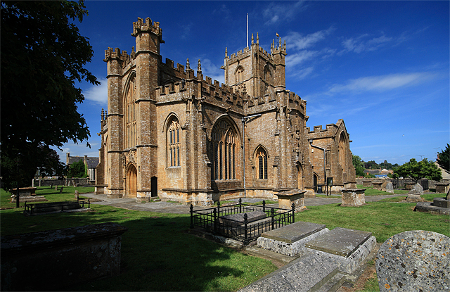
The Church of England parish church, St Bartholomew's, stands on high ground to the west of the town. The first Saxon church was founded before the end of the 9th century as a "minster", or main church of a Saxon royal estate that included an area which later became the parishes of Seaborough, Wayford and Misterton. This church was replaced after the Norman Conquest with a larger stone cruciform building, with a central tower. This was almost completely rebuilt and enlarged in the late 15th and early 16th centuries to create, for the most part, the church building visible today. It is an excellent example of the Perpendicular style with many unusual and individual features. These include the west front, the nave, the six-light aisle windows and the Tudor-style chapels and windows in the north east corner. The building material is golden-coloured Ham Hill stone, quarried nearby. There is a notable pair of 'green man' carvings within the church.
No major alterations have been made since the Reformation in the 1530s and 1540s, but there have been many changes to the interior to accommodate various phases of Church of England worship. Among these are an oven used for baking communion bread in the south east corner of the north chapel.[10] During the Civil War, considerable damage was done including the destruction of nearly all of the medieval stained glass. William III of England worshipped in the church following his landing in the Glorious Revolution of 1689.[10] By the early 19th century, all the medieval furnishings except the Norman font had disappeared. New pews were made and the west galleries were added in 1808–11. The latest restoration that has left the church interior visible today, took place in the late 19th century; it was more sympathetic to the church's architectural character than many Victorian restorations. At this time, the central section of the west gallery was removed to reveal the great west window and the organ was relocated to the south transept. The pews date from around 1900 and have attractive carved bench-ends. The church has been designated by English Heritage as a Grade I listed building.[36]
Crewkerne also contains one of very few Unitarian chapels left in the West Country, Crewkerne Unitarian Church, a tiny chapel tucked away on Hermitage Street.[37] The Methodist church on South Street is shared by Roman Catholic and Methodist congregations, following the closure and proposed redevelopment of St Peter's Catholic Church. Christ Church, a chapel of ease to St Bartholomew's, was built on South Street in 1852–54.[38] It was declared redundant in 1969 and demolished in 1975. It is now the site of the residential Christchurch Court.[39][40]
Media
[edit]Local news and television programmes are provided by BBC West in Bristol or South West from Plymouth and ITV West Country. Television signals are received from either the Mendip transmitter (West)or Stockland Hill transmitter (South West) and local relay transmitters.[41][42][better source needed]
Crewkerne's local radio stations are BBC Radio Somerset on 95.5 FM, Heart West on 97.1 FM, Greatest Hits Radio South West on 105.6 FM, and Radio Ninesprings, a community based station that broadcast on 104.5 FM.[43] [better source needed]
The Chard and Ilminster News is the local newspaper that serves the town.[44][better source needed]
Sport
[edit]The Crewkerne Aqua Centre provides swimming pool and fitness gym facilities to the town, on the grounds next to Henhayes Park, which used to be the Grammar school's playing fields.[45] St. Martins School retained the use of the playing fields until the junior section was closed in 2003, as regular sports days were a tradition dating back to the grammar school era in the town. A further sports centre is on the Wadham School campus.[46] Crewkerne Cricket Club play in the Somerset Cricket League whilst Crewkerne Rangers F.C. play in the Perry Street and District League, and Crewkerne ladies football club play in the Somerset Women's County league.[47] There are also two lawn bowls clubs in the town.
Notable residents
[edit]Thomas Coryat, a traveller and writer of the late Elizabethan and early Jacobean age was born in Crewkerne around 1577.[10] Mathematician John Caswell was also born here.[48] A later traveller, Colonel Joshua Fry, was born in the town in 1699 before becoming a surveyor, adventurer, mapmaker, soldier, and member of the House of Burgesses, the legislature of the colony of Virginia.[49] Another Englishman from Crewkerne who emigrated to the American Colonies was William Phelps who was born around 1599 and became one of the founders of both Dorchester, Massachusetts and Windsor, Connecticut, foreman of the first grand jury in New England, served most of his life in early colonial government, and played a key role in establishing the first democratic town government in the American colonies.[50] Ralph Reader, an actor, theatrical producer and songwriter, best known for staging the original Gang Show, a variety show for members of the scouting movement, was born in Crewkerne in 1903.[51] The cricketer Michael Barnwell was born in the town in 1943.[52]
Twin towns
[edit]Crewkerne is twinned with Igny, Essonne and Bures-sur-Yvette in France.[53]
References
[edit]- ^ Charter S 1507 Archived 4 March 2016 at the Wayback Machine at the Electronic Sawyer
- ^ Havinden, Michael (1981). The Somerset Landscape. The making of the English landscape. London: Hodder and Stoughton. p. 84. ISBN 0-340-20116-9.
- ^ a b Richardson, Miranda. "Crewkerne" (PDF). Somerset Extensive Urban Survey. Somerset County Council. Archived from the original (PDF) on 17 July 2011. Retrieved 22 May 2010.
- ^ "Crewkerne". National Gazetteer (1868). GenUKI. Retrieved 22 May 2010.
- ^ "Crewkerne Grammar School". The National Archives. Government of the United Kingdom. Retrieved 8 March 2012.
- ^ "Somerset Hundreds". GENUKI. Retrieved 8 October 2011.
- ^ Fry, Plantagenet Somerset, The David & Charles Book of Castles, David & Charles, 1980. ISBN 0-7153-7976-3
- ^ a b c Dunning, Robert (1980). Somerset and Avon. Edinburgh: John Bartholomew and Son. p. 70. ISBN 0-7028-8380-8.
- ^ Historic England. "Henley Manor Farmhouse (1175987)". National Heritage List for England. Retrieved 2 February 2008.
- ^ a b c d Leete-Hodge, Lornie (1985). Curiosities of Somerset. Bodmin: Bossiney Books. p. 96. ISBN 0-906456-98-3.
- ^ "Crewkerne Town Council election results 2022". 6 May 2022. Retrieved 30 May 2022.
- ^ "Crewkerne UD". A vision of Britain Through Time. University of Portsmouth. Retrieved 4 January 2014.
- ^ "West Crewkerne Parish Council, Somerset". 12 June 2018. Retrieved 30 July 2025.
- ^ "Ward population 2011". Retrieved 21 October 2015.
- ^ Historic England. "Victoria Hall (1281919)". National Heritage List for England. Retrieved 22 May 2010.
- ^ "Bincombe Beeches". Natural England. Archived from the original on 24 July 2011. Retrieved 22 May 2010.
- ^ "Bincombe Leaflet" (PDF). Crewkerne Town Council. Archived from the original (PDF) on 25 July 2011. Retrieved 22 May 2010.
- ^ "Bincombe Beeches Local Nature Reserve". Natural England. Retrieved 22 May 2010.
- ^ "Millwater" (PDF). English Nature. Archived from the original (PDF) on 13 October 2006. Retrieved 9 September 2006.
- ^ a b c d "South West England: climate". Met Office. Archived from the original on 5 June 2011. Retrieved 14 March 2010.
- ^ "Key Statistics". United Kingdom Census 2001. Office for National Statistics. Area 40UD033 in Tables KS001 (Usual resident population) and KS016 (Household spaces and accommodation type). Retrieved 23 June 2025.
- ^ "Key Statistics". United Kingdom Census 2011. Office for National Statistics. Area E04008688 in Table KS101EW (Usual resident population) and Table KS401EW (Dwellings, household spaces and accommodation type). Retrieved 23 June 2025.
- ^ "Parish Profiles". 2021 United Kingdom census. Office for National Statistics. Area E04008688 in Tables PP001 (Number of Households) and PP002 (Sex). Retrieved 5 August 2024.
- ^ "Crewkerne gives Waitrose the thumbs up". Yeovil Express. 7 January 2008. Retrieved 23 May 2010.
- ^ "Ariel Motor Co". Ariel Motor Co. Archived from the original on 30 March 2010. Retrieved 23 May 2010.
- ^ "Henhayes Centre". Henhayes Centre. Archived from the original on 5 March 2010. Retrieved 22 May 2010.
- ^ a b "Crewkerne Heritage Centre". Communigate. Archived from the original on 12 June 2011. Retrieved 27 May 2010.
- ^ "Crewkerne Heritage Centre". South Somerset Council. Retrieved 21 August 2010.
- ^ "Crewkerne Museum". Culture 24. Retrieved 27 May 2010.
- ^ "Crewkerne Train Station | South Western Railway". southwesternrailway.com. Retrieved 30 January 2021.
- ^ Phillips, Derek; Pryer, George (1997). The Salisbury to Exeter Line. Sparkford: Oxford Publishing Company. pp. 98–101. ISBN 0-86093-525-6.
- ^ Historic England. "Crewkerne Railway Station (1345931)". National Heritage List for England. Retrieved 30 January 2009.
- ^ "Information about bus, coach and train services from, and other local services in, Crewkerne". Travel Search. Carlberry. Retrieved 23 May 2010.
- ^ "The Monarch's Way". The Monarch's Way Association. Retrieved 2 February 2006.
- ^ "The Monarch's Way". The Quinton Oracle. 2005. Archived from the original on 28 August 2008. Retrieved 30 August 2008.
- ^ Historic England. "Church of St Bartholomew (1208122)". National Heritage List for England. Retrieved 6 October 2007.
- ^ "West Unitarians". Western Unitarians Congregations. Archived from the original on 10 October 2008. Retrieved 12 November 2009.
- ^ Historic England. "Monument No. 527451". Research records (formerly PastScape). Retrieved 20 November 2018.
- ^ "diocese of Bath and Wells schemes for buildings: Christchurch Court" (PDF). Archived from the original (PDF) on 16 March 2012. Retrieved 20 November 2018.
- ^ David Bryant (2013). Crewkerne Through Time. Amberley Publishing. p. 77. ISBN 978-1445611983.
- ^ "Full Freeview on the Mendip (Somerset, England) transmitter". UK Free TV. 1 May 2004. Retrieved 3 October 2023.
- ^ "Freeview Light on the Crewkerne (Somerset, England) transmitter". UK Free TV. 1 May 2004. Retrieved 3 October 2023.
- ^ "Radio Ninesprings". Retrieved 3 October 2023.
- ^ "Chard and Ilminster News". British Papers. 10 September 2013. Retrieved 2 October 2023.
- ^ "Crewkerne Aqua Centre". Crewkerne Aqua Centre. Archived from the original on 10 April 2010. Retrieved 23 May 2010.
- ^ "Crewkerne Sports Centre". Somerset County Council. Archived from the original on 21 June 2011. Retrieved 23 May 2010.
- ^ "Perry Street & District League". TheFA.com. Retrieved 8 May 2012.
- ^ Henry, John (September 2010). "Keill, John (1671–1721)". Oxford Dictionary of National Biography. Oxford University Press. Retrieved 28 May 2012. (subscription, Wikipedia Library access or UK public library membership required)
- ^ Stannard, W.G. (1894). "Virginians at Oxford". The William and Mary Quarterly. 2 (3): 149–153. doi:10.2307/1915310. JSTOR 1915310.
- ^ "First generation of Phelps in Windsor, Connecticut". Phelps Family History. Archived from the original on 10 February 2010. Retrieved 25 August 2010.
- ^ "Ralph Reader CBE". Hinkley Gang Show. Retrieved 23 May 2010.
- ^ "Mike Barnwell". CricInfo. Retrieved 13 June 2010.
- ^ "Crewkerne – Banking Court Neighbourhood Plan". Yarlington Housing Group. Archived from the original on 8 January 2014. Retrieved 6 June 2012.
External links
[edit]
| International | |
|---|---|
| National | |
| Geographic | |
| Other | |
Crewkerne
View on GrokipediaHistory
Early and Medieval Periods
Archaeological evidence points to limited prehistoric activity in the Crewkerne area, including a Neolithic polished stone axe found in 1958, though no settlement is attested on the later town site.[4] Roman artifacts, such as coins discovered around 1900 east of the town and a bronze dog statuette, indicate proximity to Roman activity, but no direct settlement evidence exists.[4] The name Crewkerne derives from Old British terms cruc (hill) and aern (house or storehouse), likely referencing a structure on nearby Bincombe Hill.[5] A settlement predated the Anglo-Saxon period, with Crewkerne serving as the center of a large royal estate by the late 9th century.[4] The earliest written record appears in the 899 will of King Alfred the Great, who bequeathed the estate to his youngest son, Æthelweard.[5] Alfred enhanced its role as a hub for commerce, trade, and resistance against Danish incursions, granting tax-free status and establishing a minster church, mint, and market.[5] The mint operated under kings Æthelred II (978–1016) and Cnut (1016–1035), producing coins now held in collections like the Royal Cabinet in Stockholm.[5][4] In the Domesday Book of 1086, Crewkerne is described as a royal manor in the hundred of Crewkerne, with 102.5 households comprising villagers, smallholders, slaves, and others.[6] Holdings were divided: King William and Count Robert of Mortain controlled portions with 40 ploughlands, 25 plough teams, 60 acres of meadow, pasture, woodland, four mills valued at 2 pounds, and livestock including 400 sheep; the Abbey of Caen held 13 ploughlands, 13 plough teams, a mill worth 5 shillings, and a church, with a total valuation rising to 59 pounds by 1086.[6] The market ranked as the second most valuable in Somerset, underscoring early economic prominence.[3] Medieval development saw urban functions expand, with planned roads like Lyme Street and market infilling by the late 13th century.[4] The Church of St Bartholomew, built on the Saxon minster site, retains minor pre-15th-century features and was rebuilt on a grand scale from the late 15th to early 16th century amid wool prosperity.[5] A grammar school, among England's earliest, was founded in 1499.[3] The hundred of Crewkerne, predating the Norman Conquest, encompassed surrounding villages and reinforced the manor's administrative role.[4]Textile Industry and Economic Growth
The textile industry in Crewkerne originated in the medieval period, driven by local sheep farming and wool production suited to the region's mild, damp climate. By the late 1400s, prosperity from wool processing and trade funded the rebuilding of the Church of St Bartholomew as a large perpendicular-style parish church, reflecting the town's emerging economic significance.[7][3] In the 18th century, the industry expanded into specialized cloth production, including linen and woollen girth webbing, with Viney Bridge Mills established in 1789 by Samuel Sparks and Bartholomew Gidley near Misterton. Sailcloth manufacturing grew from cottage-based operations to larger-scale enterprises, producing high-quality Coker canvas prized for naval use, while webbing supported military and equestrian needs. By 1828, the area hosted 27 sailcloth firms, underscoring the sector's role in regional specialization.[8][9][5] The 19th-century Industrial Revolution amplified growth, incorporating flax cultivation alongside wool for cloth processing and diversifying into shirts and other garments. The West Somerset & Devon Shirt Company opened its first factory in 1872, with facilities like the Abbey Street shirt factory operational by around 1860; by the 1851 census, textiles employed over 20% of the local workforce, fueling population increase and infrastructure development. This expansion positioned Crewkerne as a key textile hub on the Somerset-Dorset border, with output tied to naval and military demands during the Napoleonic era and beyond.[10][7][5]Modern Developments and Decline
The textile industry in Crewkerne reached its zenith in the first half of the 19th century, with diversification into sailcloth production supporting over 20% of the local workforce by 1851 and fueling population growth from 2,567 in 1801 to 5,093 in 1851.[3][5] By 1828, the area hosted 27 sailcloth firms, reflecting the town's role in supplying the Royal Navy amid expanding maritime demands.[5] A key modern development was the arrival of the railway, with Crewkerne station opening on 19 July 1860 as part of the London and South Western Railway's line to Exeter, designed by architect William Tite and later designated a Grade II listed building.[11][12] This infrastructure enhanced accessibility, boosted trade, and supported lingering industrial activity despite emerging challenges.[13] Decline set in during the late 1850s and 1860s as textile production shifted to northern England, where coal and steam power enabled mechanized mills, eroding Crewkerne's competitive edge in woolens and sailcloth.[14] By the late 19th century, the transition from sail to steam shipping further diminished demand for local fabrics, leading to relative economic stagnation into the early 20th century with minimal new construction and preservation of the town's late Georgian architectural character.[5] Traditional industries waned, though some garment production persisted, as evidenced by the 1953 acquisition of a local shirt factory by Van Heusen, before broader post-war shifts in manufacturing contributed to further contraction.[15]Recent History (20th-21st Centuries)
In the early 20th century, Crewkerne experienced relative economic stagnation following the peak of its textile industries, with limited new construction reflecting a broader decline in traditional manufacturing sectors.[5] This period saw the town maintaining its role as a rural market center in South Somerset, but without significant industrial expansion until mid-century shifts.[4] During World War II, Crewkerne contributed to national defense efforts, including the construction of concrete pillboxes along key routes like the A30 to form anti-tank obstacles against potential invasion, with at least one such structure preserved near Yeovil Road.[16][17] Nearby RAF Merryfield operated as an airbase supporting Allied operations, while local fields were used for vegetable production to aid wartime food supplies, as evidenced by 1946 aerial imagery showing cultivated areas like Chubb's Lawn.[13] The town's war memorial in Severals Park, dedicated in 1922 for World War I, was later expanded to honor World War II casualties and post-1945 conflicts.[18] Post-war reconstruction from the 1950s onward involved targeted rebuilding and suburban expansion, incorporating modern housing and infrastructure amid national recovery initiatives, though Crewkerne's growth remained modest compared to urban centers.[4] Traditional industries continued to wane, giving way to diversified employment in services, light manufacturing, and commuting to nearby Yeovil, with the population stabilizing around 7,000-8,000 by the late 20th century.[13] Entering the 21st century, Crewkerne has undergone accelerated residential development to address regional housing needs, including the Wool Gardens project commencing in 2021, which plans 635 homes, a primary school, shops, and community facilities, with 50 units designated affordable.[19] Further proposals, such as 325 homes on a 16.61-hectare site along Station Road submitted in September 2025 and 70 homes approved in nearby Misterton in August 2024, have sparked local concerns over infrastructure strain, with residents warning of a "breaking point" due to inadequate services like roads and schools.[20][21][22] These expansions reflect Somerset Council's growth policies but highlight tensions between development and sustainable capacity in this historic market town.[23]Geography
Location and Topography
Crewkerne occupies a position in the South Somerset district of Somerset, within South West England, at coordinates 50°53′N 2°48′W.[24] The town sits approximately 14 km southwest of Yeovil and 11 km east of Chard, along the A30 road that links it to regional transport networks.[25] This placement positions Crewkerne near the Dorset border, facilitating access to the M5 motorway roughly 20 km westward. The local topography consists of a shallow valley landscape, with the town centre elevated at about 74 m (243 ft) above sea level.[26] Within 3 km, terrain variations reach up to 173 m, reflecting the undulating hills bordering the flatter Somerset Levels.[27] The area features Lower Lias Jurassic formations, dissected by rivers such as the Parrett, which flows adjacent to the south and shapes the narrow valley accommodating the settlement.[28] An average elevation across the broader vicinity stands at 88 m.[29]Climate and Environment
Crewkerne exhibits a temperate oceanic climate typical of inland South West England, influenced by the Atlantic, resulting in mild temperatures and relatively high humidity. Annual average high temperatures reach approximately 13.5°C, with lows around 8.8°C; summers peak at about 22°C in July, while January averages 9°C. Winters rarely drop below -3°C, and extremes above 24°C are uncommon. Precipitation totals around 817 mm yearly, with the wettest month being October at 79 mm, contributing to frequent overcast conditions and occasional flooding risks in the Parrett valley.[26][30][31] The town's environment features undulating terrain in the South Somerset Hills, with clay vales and escarpments supporting mixed farmland and woodland. Proximity to the River Parrett enhances biodiversity, though the area faces pressures from agricultural runoff and urban expansion. Local conservation efforts include the 12-acre Bincombe Beeches Local Nature Reserve, managed by Crewkerne Town Council as a semi-natural woodland haven for native species and public recreation. The council also oversees tree preservation and listed building maintenance to mitigate development impacts.[32][28] Environmental challenges include resident concerns over traffic congestion and air pollution from housing growth, exemplified by a 2022 petition of 299 signatures highlighting increased vehicle emissions near new sites. Broader Somerset issues, such as episodic stream pollution from farms, underscore the need for regulatory compliance, though Crewkerne-specific data shows no acute industrial contamination. The town council promotes low-carbon initiatives, including renewable energy schemes, aligning with regional ecological emergency responses.[33][34][35]Governance and Politics
Local Government Structure
Crewkerne is governed by a two-tier local authority structure comprising Somerset Council as the upper-tier unitary authority and Crewkerne Town Council as the parish-level authority.[36] Somerset Council was formed on 1 April 2023 by merging Somerset County Council with the five district councils, including South Somerset, to streamline services across the county.[36] This unitary body handles strategic responsibilities such as education, social care, highways maintenance, waste collection, and planning applications.[37] Crewkerne is represented by two councillors on Somerset Council.[36] Crewkerne Town Council, operating from the Town Hall in Market Square, focuses on hyper-local services including the maintenance of parks, playgrounds, allotments, public toilets, the war memorial, and community events.[38] [39] The council comprises elected councillors divided into wards, who convene in a structured meeting format: the Full Council meets monthly except in August, the Planning & Highways Committee meets monthly, the Amenities Committee bi-monthly, and the Policy & Resources Committee quarterly.[40] Additional bodies include the Joint Burial Committee, which meets four times annually.[40] Coordination between tiers occurs through the Crewkerne and Ilminster Local Community Network, which encompasses Crewkerne, Ilminster, and 31 surrounding parishes with a combined population exceeding 31,000; this network facilitates resident engagement, partnership working, and addresses local priorities like transport and community development.[41] The Town Council also maintains open surgeries for public interaction with councillors.[42]Political Representation and Elections
Crewkerne falls within the Yeovil parliamentary constituency, represented in the UK House of Commons by Adam Dance of the Liberal Democrats, who was elected on 4 July 2024 with 21,929 votes, defeating the previous Conservative incumbent Marcus Fysh.[43][44] The constituency encompasses parts of south Somerset, including Crewkerne, and prior to 2024 had been held by Conservatives since 2015.[44] At the local level, Crewkerne is represented by two councillors on Somerset Council—the unitary authority covering the area since the 2023 merger of Somerset County Council and district councils—in the Crewkerne division: Mike Best and Steve Ashton, both Liberal Democrats.[45] These councillors were elected in the inaugural Somerset Council election on 5 May 2022, where the Liberal Democrats secured overall control of the 110-seat council amid a swing from Conservatives.[46] Crewkerne Town Council, responsible for parish-level services, consists of 12 members elected on 5 May 2022 for a term ending in 2027, with the next election scheduled for May 2027.[47][48] The 2022 poll saw a mix of candidates from the Liberal Democrats and Conservative Party elected, including Paul Michael Maxwell (Liberal Democrats, 893 votes) and Steve Ashton (Conservative Party, 838 votes), reflecting competitive local contests.[49] The council's composition includes figures such as Mayor Kathy Head, re-elected in 2022 for her fifth term.[50]Policy Debates and Local Issues
In recent years, policy debates in Crewkerne have centered on rapid housing development straining local infrastructure, with residents arguing that the town's roads, schools, and services are already at "breaking point." Proposals for 325 homes on Station Road, submitted in September 2025, drew over 100 objections, citing potential gridlock on the A356 and overwhelmed utilities without corresponding upgrades.[20] Similarly, Somerset Council refused outline permission for 145 homes at Kit Hill in July 2024 due to inadequate design, insufficient garden space, and failure to integrate with the landscape, prompting developers to appeal.[51] Earlier concerns in 2023 highlighted fears over 1,000 new homes by 2028 exacerbating these pressures without proportional investment in amenities.[52] Traffic management has emerged as a flashpoint, with locals decrying chronic congestion from heavy goods vehicles, the one-way system in the town center, and inadequate highways coordination by Somerset Council. Residents in 2025 reported frequent gridlock on key routes like the A30 and A358, attributing it to development-linked increases in heavy traffic and pollution, which some link to health risks such as respiratory issues.[20] Delays in promised link roads, such as at the Broadshard development, have forced new residents to route through industrial estates, isolating communities and prompting calls for enforceable developer obligations.[53] Local Community Network meetings in 2023-2024 identified highways as a priority, advocating for active travel improvements amid poor public transport links.[54] Environmental and service provision debates include opposition to green space loss, with petitions in 2023 urging preservation of fields for public parks amid housing encroachment, and concerns over hedgerow destruction impacting wildlife.[55] Healthcare access has also surfaced, exemplified by a 2025 petition to retain inpatient beds at Crewkerne Community Hospital amid regional cuts. Crewkerne Town Council minutes reflect ongoing scrutiny of planning applications for drainage and runoff issues, emphasizing sustainable development over unchecked growth.[56] These tensions underscore broader Somerset-wide challenges in reconciling national housing targets with local capacity limits.[57]Demographics
Population Trends and Growth
The population of Crewkerne parish increased from 2,576 in 1801 to a peak of 4,986 in 1881, reflecting broader rural-urban shifts and early industrial activity in Somerset.[58] This growth slowed after 1851, with a decline to 3,509 by 1931, likely influenced by agricultural depression and out-migration to larger urban centers.[58] Post-World War II recovery saw numbers rise to 4,215 by 1961, driven by national trends in suburbanization and improved transport links.[58] Subsequent decades marked sustained expansion, with the parish reaching 7,327 residents by the 2021 census, representing a roughly 74% increase from 1961 levels.[2] This aligns with South Somerset's 7% district-wide growth between 2011 and 2021, attributed to housing development, commuting to nearby Yeovil, and an aging population structure.[59] Recent annual growth in the Crewkerne built-up area averages 0.48%, below national averages but indicative of steady, modest expansion amid regional economic stability.[60]| Census Year | Population (Crewkerne Parish) |
|---|---|
| 1801 | 2,576 |
| 1841 | 4,414 |
| 1851 | 4,497 |
| 1881 | 4,986 |
| 1901 | 4,226 |
| 1931 | 3,509 |
| 1961 | 4,215 |
| 2021 | 7,327 |
Ethnic Composition and Migration
In the 2021 United Kingdom census, Crewkerne parish had a population of 7,327, with ethnic groups distributed as follows:| Ethnic Group | Number | Percentage |
|---|---|---|
| White | 7,148 | 97.6% |
| Asian, Asian British or Asian Welsh | 55 | 0.8% |
| Mixed or multiple ethnic groups | 77 | 1.1% |
| Black, Black British, Black Welsh, Caribbean or African | 18 | 0.2% |
| Other ethnic groups | 29 | 0.4% |