Community hub
Recent from talks
Contribute something
Nothing was collected or created yet.
EuroVelo
View on Wikipedia| EuroVelo | |
|---|---|
Logo | |
 | |
| System information | |
| Length | 55,923 mi (89,999 km) |
| Formed | 1995 |
| Highway names | |
| EuroVelo | EV nn |
| System links | |
This article needs to be updated. (July 2023) |
EuroVelo is a network of 17 long-distance cycling routes criss-crossing Europe, with 2 more in early construction across various stages of completion. When completed, the EuroVelo network's total length will be almost 60,875 km (37,826 mi).[1][2] As of 2023[update] more than 56,000 km (35,000 mi) were in place.[3] EuroVelo is a project of the European Cyclists' Federation (ECF). The multinational project aims to connect 40 countries via the 19 unique routes across the European continent.
EuroVelo routes can be used for bicycle touring across the continent, as well as by local people making short journeys. The routes are made of both existing national bike routes — such as the Dutch LF-Routes, the German D-Routes, the French véloroute "SN3V" and the British National Cycle Network — and existing general purpose roads, together with new stretches of cycle routes to connect them.[4]
History
[edit]The idea of creating a network of international cycle routes spanning Europe started in 1995. It was initially coordinated by the ECF, De Frie Fugle (Denmark) and Sustrans (UK) and the original plan was to create 12 long-distance cycling routes.
Since August 2007, the ECF has assumed full responsibility for the project. Despite sometimes tight financial constraints, the EuroVelo project has already begun to fulfil the vision of its founders with sections of the network being implemented in countries as far apart as Finland, Cyprus, Spain and the UK. In addition, the EuroVelo brand has become widely known.
There have been various changes to the network over the years, most notably the addition of two new routes — EuroVelo 13 (the Iron Curtain Trail) and EuroVelo 15 (the Rhine Cycle Route) — in September 2011, which are the longest and shortest of the EuroVelo routes.[5]
Future expansion
[edit]In September 2023, the ECF announced that the Iberian Cycle route connecting Lisbon with Pamplona via Madrid is set to become the future EuroVelo 16 route by 2028 with a length of 1,896 km.[6]
Main points on the EuroVelo routes
[edit]| Route number | Route name | Passes through these cities | Through these countries | Length | |
|---|---|---|---|---|---|
| km | mi | ||||
| Atlantic Coast Route | North Cape (EV7, EV11) - Tromsø - Vestvågøy - Trondheim (EV3) - Bergen (EV12) - Aberdeen (EV12) - Inverness (EV12 ) - Glasgow - Stranraer - Belfast - Lisburn - Strabane - Derry - Sligo - Galway (EV2) - Limerick - Waterville - Cork - Rosslare - Fishguard - Newport - Bristol (EV2) - Plymouth - Roscoff (EV4) - Nantes (EV6) - La Rochelle - Arcachon - Bayonne - Hendaye - Irun - Pamplona (EV3) - Burgos - Valladolid - Salamanca - Cáceres - Ayamonte - Faro - Sagres - Lisbon - Porto - Caminha | 10,650 | 6,620 | ||
| Capitals Route | Galway (EV1) - Athlone - Dublin - Holyhead - Bristol (EV1) - Bath - Reading - London (EV12) - Harwich - Hoek van Holland (EV12, EV15, EV19) - The Hague (EV12) - Utrecht - Münster (EV3) - Dessau - Berlin (EV7) - Poznań (EV9) - Warsaw (EV11) - Minsk - Moscow | 5,050 | 3,140 | ||
| Pilgrims Route | Trondheim (EV1) - Lillehammer - Oslo - Halden - Strömstad - Gothenburg (EV12) - Frederikshavn (EV12) - Aalborg - Viborg - Vejen - Padborg - Flensburg - Hamburg (EV12) - Münster (EV2) - Wesel (EV15) - Düsseldorf (EV4) - Cologne - Aachen - Liège (EV19) - Namur (EV5, EV19) - Charleroi - Maubeuge - Paris - Orléans (EV6) - Tours (EV6) - Bordeaux - Saint-Jean-Pied-de-Port - Roncesvalles - Pamplona (EV1) - Logroño - Burgos - Frómista (EV1) - León - Ponferrada - Sarria - Santiago de Compostela | 5,650 | 3,510 | ||
| Central Europe Route | Roscoff (EV1) - Mont-Saint-Michel - Cherbourg - Le Havre - Calais (EV5, EV12) - Vlissingen (EV12) - Venlo - Düsseldorf (EV3, EV15) - Bonn (EV3, EV15) - Frankfurt - Cheb (EV13) - Karlovy Vary - Prague (EV7) - Brno (EV9) - Kraków (EV11) - Lviv - Kyiv | 5,100 | 3,200 | ||
| Via Romea Francigena | Canterbury (EV12) - Dover (EV12) - Calais (EV4, EV12) - Lille - Brussels - Namur (EV3, EV19) - Luxembourg - Saarbrücken - Strasbourg (EV15) - Mulhouse (EV6) - Basel (EV6, EV15) - Andermatt (EV15, EV17) - Lucerne - Milan - Pavia (EV8) - Piacenza (EV8) - Lucca - Siena - Rome (EV7) - Benevento - Brindisi | 3,200 | 2,000 | ||
| Atlantic – Black Sea Route | Saint-Brevin-les-Pins (EV1) - Nantes (EV1) - Tours (EV3) - Orléans - Besançon - Mulhouse (EV5) - Basel (EV5, EV15) - Radolfzell - Ulm - Regensburg - Passau (EV7) - Linz (EV7) - Vienna (EV9) - Bratislava (EV13) - Budapest - Osijek - Belgrade - Pančevo (EV11) - Bela Crkva (EV13) - Drobeta-Turnu Severin (EV13) - Vidin/Calafat - Ruse/Giurgiu - Silistra - Brăila - Constanța | 4,450 | 2,770 | ||
| Sun Route | North Cape (EV1, EV11) - Haparanda (EV10) - Sundsvall (EV10) - Gothenburg (EV3, EV12) - Helsingborg - Copenhagen (EV10) - Gedser - Rostock (EV10, EV13) - Berlin (EV2) - Dresden - Prague (EV4) - Linz (EV6) - Salzburg - Bolzano - Mantua (EV8) - Bologna - Florence - Rome (EV5) - Naples - Catanzaro - Catania - Valletta | 7,700 | 4,800 | ||
| Mediterranean Route | Cádiz - Málaga - Almería - Murcia - Alicante - Valencia - Barcelona - Béziers - Sète (EV17) - Cannes - Nice - Turin - Pavia (EV5) - Mantua (EV7) - Venice - Trieste (EV9) - Koper - Pula (EV9) - Zadar - Split - Dubrovnik - Tivat - Kotor - Shkodër - Tirana - Vlorë - Patras - Athens (EV11) - Bergama - İzmir - Selçuk - Nicosia - Larnaca - Limassol - Paphos - Polis - Nicosia | 7,500 | 4,700 | ||
| Baltic - Adriatic | Gdańsk (EV10, EV13) - Bydgoszcz - Poznań (EV2) - Wrocław - Olomouc - Brno (EV4) - Břeclav - Vienna (EV6) - Maribor - Ljubljana - Trieste (EV8) - Pula (EV8) | 2,050 | 1,270 | ||
| Baltic Sea Cycle Route | Gdańsk (EV9, EV13) - Rostock (EV7, EV13) - Kiel - Sønderborg - Copenhagen (EV7) - Malmö - Kalmar - Stockholm - Sundsvall (EV7) - Umeå (EV7) - Oulu (EV11) - Vaasa - Turku - Helsinki (EV11) - Virolahti (EV13) - Saint Petersburg (EV13) - Tallinn (EV11, EV13) - Riga (EV13) - Klaipėda (EV13) - Kaliningrad (EV13) - Gdańsk | 9,000 | 5,600 | ||
| East Europe Route | North Cape (EV1, EV7) - Inari (EV13) - Rovaniemi - Oulu (EV10) - Kuopio - Helsinki (EV10) - Tallinn (EV10, EV13) - Tartu - Daugavpils - Vilnius - Warsaw (EV2) - Kraków (EV4) - Košice - Szeged (EV13) - Pančevo (EV6) - Skopje - Thessaloniki - Larissa - Athens (EV8) | 6,550 | 4,070 | ||
| North Sea Cycle Route | Bergen (EV1) - Stavanger - Kristiansand - Gothenburg (EV3) - Halmstad - Grenaa - Esbjerg - Hamburg (EV3) - Bremerhaven - Den Helder - The Hague (EV2) - Vlissingen (EV4) - Dunkirk - Calais (EV4, EV5) - Dover (EV5) - Canterbury (EV5) - London (EV2) - Norwich - Hull - Newcastle - Edinburgh - Aberdeen (EV1) - Inverness (EV1) - Thurso - Orkney Islands - Shetland Islands - Bergen | 7,050 | 4,380 | ||
| Iron Curtain Trail | Grense Jakobselv - Kirkenes - Inari (EV11) - Sodankylä (EV11) - Suomussalmi - Lappeenranta - Saint Petersburg (EV10) - Tallinn (EV10, EV11) - Riga (EV10) - Klaipėda (EV10) - Kaliningrad (EV10) - Gdańsk (EV 9, EV10) - Greifswald (EV10) - Rostock (EV7, EV10) - Lübeck - Eschwege - Cheb (EV4) - Bratislava (EV6) - Donji Miholjac - Szeged (EV11) - Vršac - Drobeta-Turnu Severin (EV6) - Zaječar - Pirot - Kyustendil - Strumica - Petrich - Smolyan - Kyprinos - Edirne - Kırklareli - Malko Tarnovo - Rezovo | 9,950 | 6,180 | ||
| Waters of Central Europe | Zell Am See - Bischofshofen (EV7) - Liezen - Graz - Fehring (EV9) - Gleisdorf - Szentgotthárd (EV13) - Keszthely - Székesfehérvár - Velence | 1,125 | 699 | ||
| Rhine Cycle Route | Andermatt (EV5, EV17) - Chur - Grabs - Lustenau - Konstanz - Öhningen - Schaffhausen - Basel (EV5, EV6) - Rosenau/Weil am Rhein - Biesheim/Breisach - Strasbourg - Karlsruhe - Mannheim - Worms/Biebesheim am Rhein - Mainz (EV4) - Bingen (EV4) - Koblenz (EV4) - Bonn (EV3, EV4)) - Cologne (EV3, EV4) - Düsseldorf (EV3) - Duisburg (EV3) - Rheinberg/Wesel - Xanten/Emmerich am Rhein - Arnhem (EV2) - Leerdam - Rotterdam (EV19) - Hoek van Holland (E2, EV12, EV19) | 1,500 | 930 | ||
| Rhone Cycle Route | Andermatt (EV5, EV15) - Furka Pass - Brig - Sierre - Sitten - Martigny - Saint Gingolph/Vevey - Thonon-les-Bains/Lausanne - Geneva - Lyon - Valence - Avignon - Tarascon East branch: Tarascon - Arles - Port-Saint-Louis-du-Rhône West branch: Tarascon - Saint-Gilles - Palavas-les-Flots - Sète (EV8) |
1,250 | 780 | ||
| Meuse Cycle Route | Langres - Neufchâteau - Commercy - Verdun - Stenay - Charleville-Mézières - Dinant - Namur (EV3, EV5) - Liège - Maastricht - Venlo - Cuijk - Den Bosch - Dordrecht - Hoek van Holland (EV2, EV12, EV15) - Rotterdam (EV15) | 1,050 | 650 | ||
- Routes EV10 and EV12 are a circular tour
- Connections to other EV routes are in parentheses
- Odd routes are heading north–south, even routes are heading west–east
Route information
[edit]EuroVelo 1 – Atlantic Coast Route
[edit]
Stretching the length of the continent, from North Cape, Norway to Valença, Portugal, the EV1 connects Norway, Scotland, Northern Ireland, the Republic of Ireland, Wales, the West Country of England, France, Spain and Portugal.[7]
EuroVelo 2 – Capitals Route
[edit]EuroVelo 2 | |||||||||||||||||||||||||||||||||||||||||||||||||||||||||||||||||||||||||||||||||||||||||||||||||||||||||||||||||||||||||||||||||||||||||||||||||||||||||||||||||||||||||||||||||||||||||||||||||||||||||||||||||||||||||||||||||||||||||||||||||||
|---|---|---|---|---|---|---|---|---|---|---|---|---|---|---|---|---|---|---|---|---|---|---|---|---|---|---|---|---|---|---|---|---|---|---|---|---|---|---|---|---|---|---|---|---|---|---|---|---|---|---|---|---|---|---|---|---|---|---|---|---|---|---|---|---|---|---|---|---|---|---|---|---|---|---|---|---|---|---|---|---|---|---|---|---|---|---|---|---|---|---|---|---|---|---|---|---|---|---|---|---|---|---|---|---|---|---|---|---|---|---|---|---|---|---|---|---|---|---|---|---|---|---|---|---|---|---|---|---|---|---|---|---|---|---|---|---|---|---|---|---|---|---|---|---|---|---|---|---|---|---|---|---|---|---|---|---|---|---|---|---|---|---|---|---|---|---|---|---|---|---|---|---|---|---|---|---|---|---|---|---|---|---|---|---|---|---|---|---|---|---|---|---|---|---|---|---|---|---|---|---|---|---|---|---|---|---|---|---|---|---|---|---|---|---|---|---|---|---|---|---|---|---|---|---|---|---|---|---|---|---|---|---|---|---|---|---|---|---|---|---|---|---|---|
| |||||||||||||||||||||||||||||||||||||||||||||||||||||||||||||||||||||||||||||||||||||||||||||||||||||||||||||||||||||||||||||||||||||||||||||||||||||||||||||||||||||||||||||||||||||||||||||||||||||||||||||||||||||||||||||||||||||||||||||||||||
EV2 runs between Galway, Ireland to Moscow, Russia visiting some capital cities along the way, from Eyre Square to Red Square.
Between The Hague in the Netherlands and the German-Polish border, the EV2 follows the bicycle route called European Bicycle Route R1 or Euro-Route R1,[8] an international long-distance cycling route connecting Boulogne-sur-Mer in France with St Petersburg in Russia.
EuroVelo 3 – Pilgrims Route
[edit]EuroVelo 3 | |||||||||||||||||||||||||||||||||||||||||||||||||||||||||||||||||||||||||||||||||||||||||||||||||||||||||||||||||||||||||||||||||||||||||||||||||||||||||||||||||||||||||||||||||||||||||||||||||||||||||||||||||||||||||||||||||||||||||||||||||||||||||||||||||||||||||||||||||||||||||||||||||||||||||||||||||||||||||||||||||||||||
|---|---|---|---|---|---|---|---|---|---|---|---|---|---|---|---|---|---|---|---|---|---|---|---|---|---|---|---|---|---|---|---|---|---|---|---|---|---|---|---|---|---|---|---|---|---|---|---|---|---|---|---|---|---|---|---|---|---|---|---|---|---|---|---|---|---|---|---|---|---|---|---|---|---|---|---|---|---|---|---|---|---|---|---|---|---|---|---|---|---|---|---|---|---|---|---|---|---|---|---|---|---|---|---|---|---|---|---|---|---|---|---|---|---|---|---|---|---|---|---|---|---|---|---|---|---|---|---|---|---|---|---|---|---|---|---|---|---|---|---|---|---|---|---|---|---|---|---|---|---|---|---|---|---|---|---|---|---|---|---|---|---|---|---|---|---|---|---|---|---|---|---|---|---|---|---|---|---|---|---|---|---|---|---|---|---|---|---|---|---|---|---|---|---|---|---|---|---|---|---|---|---|---|---|---|---|---|---|---|---|---|---|---|---|---|---|---|---|---|---|---|---|---|---|---|---|---|---|---|---|---|---|---|---|---|---|---|---|---|---|---|---|---|---|---|---|---|---|---|---|---|---|---|---|---|---|---|---|---|---|---|---|---|---|---|---|---|---|---|---|---|---|---|---|---|---|---|---|---|---|---|---|---|---|---|---|---|---|---|---|---|---|---|---|---|---|---|---|---|---|---|---|---|---|---|---|---|---|---|---|---|---|---|---|---|---|---|---|---|---|---|---|---|---|---|---|---|---|
| |||||||||||||||||||||||||||||||||||||||||||||||||||||||||||||||||||||||||||||||||||||||||||||||||||||||||||||||||||||||||||||||||||||||||||||||||||||||||||||||||||||||||||||||||||||||||||||||||||||||||||||||||||||||||||||||||||||||||||||||||||||||||||||||||||||||||||||||||||||||||||||||||||||||||||||||||||||||||||||||||||||||
EV3 goes from Trondheim in Norway to Santiago de Compostela in Spain. The route follows traces of old roads used for pilgrimages in the Middle Ages. The route passes through Norway, Sweden, Denmark, Germany, Belgium, France and Spain. Most of these countries have a developed network of bicycle routes used as part of the EV3.
EuroVelo 4 – Central Europe Route
[edit]EuroVelo 4 | ||||||||||||||||||||||||||||||||||||||||||||||||||||||||||||||||||||||||||||||||||||||||||||||||||||||||||||||||||||||||||||||||||||||||||||||||||||||||||||||||||||||||||||||||||||||||||||||||||||||||||||||||||||||||||||||||||||||||||||
|---|---|---|---|---|---|---|---|---|---|---|---|---|---|---|---|---|---|---|---|---|---|---|---|---|---|---|---|---|---|---|---|---|---|---|---|---|---|---|---|---|---|---|---|---|---|---|---|---|---|---|---|---|---|---|---|---|---|---|---|---|---|---|---|---|---|---|---|---|---|---|---|---|---|---|---|---|---|---|---|---|---|---|---|---|---|---|---|---|---|---|---|---|---|---|---|---|---|---|---|---|---|---|---|---|---|---|---|---|---|---|---|---|---|---|---|---|---|---|---|---|---|---|---|---|---|---|---|---|---|---|---|---|---|---|---|---|---|---|---|---|---|---|---|---|---|---|---|---|---|---|---|---|---|---|---|---|---|---|---|---|---|---|---|---|---|---|---|---|---|---|---|---|---|---|---|---|---|---|---|---|---|---|---|---|---|---|---|---|---|---|---|---|---|---|---|---|---|---|---|---|---|---|---|---|---|---|---|---|---|---|---|---|---|---|---|---|---|---|---|---|---|---|---|---|---|---|---|---|---|---|---|---|---|---|---|---|
| ||||||||||||||||||||||||||||||||||||||||||||||||||||||||||||||||||||||||||||||||||||||||||||||||||||||||||||||||||||||||||||||||||||||||||||||||||||||||||||||||||||||||||||||||||||||||||||||||||||||||||||||||||||||||||||||||||||||||||||
The EV4 goes from Roscoff, France to Kyiv, Ukraine, going through France, Belgium, the Netherlands, Germany, the Czech Republic, Poland, and Ukraine.
EuroVelo 5 – Via Romea Francigena
[edit]EuroVelo 5 | ||||||||||||||||||||||||||||||||||||||||||||||||||||||||||||||||||||||||||||||||||||||||||||||||||||||||||||||||||||||||||||||||||||||||||||||||||||||||||||||||||||||||||||||||||||||||||||||||||||||||||||||||||||||||||||||||||
|---|---|---|---|---|---|---|---|---|---|---|---|---|---|---|---|---|---|---|---|---|---|---|---|---|---|---|---|---|---|---|---|---|---|---|---|---|---|---|---|---|---|---|---|---|---|---|---|---|---|---|---|---|---|---|---|---|---|---|---|---|---|---|---|---|---|---|---|---|---|---|---|---|---|---|---|---|---|---|---|---|---|---|---|---|---|---|---|---|---|---|---|---|---|---|---|---|---|---|---|---|---|---|---|---|---|---|---|---|---|---|---|---|---|---|---|---|---|---|---|---|---|---|---|---|---|---|---|---|---|---|---|---|---|---|---|---|---|---|---|---|---|---|---|---|---|---|---|---|---|---|---|---|---|---|---|---|---|---|---|---|---|---|---|---|---|---|---|---|---|---|---|---|---|---|---|---|---|---|---|---|---|---|---|---|---|---|---|---|---|---|---|---|---|---|---|---|---|---|---|---|---|---|---|---|---|---|---|---|---|---|---|---|---|---|---|---|---|---|---|---|---|---|---|---|---|---|
| ||||||||||||||||||||||||||||||||||||||||||||||||||||||||||||||||||||||||||||||||||||||||||||||||||||||||||||||||||||||||||||||||||||||||||||||||||||||||||||||||||||||||||||||||||||||||||||||||||||||||||||||||||||||||||||||||||
The EV5 route is inspired by the Via Francigena, a pilgrimage route from London to Rome first recorded by Archbishop of Canterbury Sigeric in the 10th century AD. However, the route of the true Via Francigena is an almost straight line path from London to Rome, while the EuroVelo 5 route takes a more easterly route that passes through Brussels, Luxembourg and Strasbourg in the Alsace. It then follows the Franco-German border, passes through Switzerland following Swiss National Bike Route no. 3, before crossing the Alps at the Gotthard Pass. It then passes through Italy (more closely following Sigeric's route) to Rome before continuing on to the Adriatic port city of Brindisi.
EuroVelo 6 – River Route
[edit]EuroVelo 6 | ||||||||||||||||||||||||||||||||||||||||||||||||||||||||||||||||||||||||||||||||||||||||||||||||||||||||||||||||||||||||||||||||||||||||||||||||||||||||||||||||||||||||||||||||||||||||||||||||||||||||||||||||||||||||||||||||||||||||||||||||||||||||||||||||||||||||||||||||||||||||||||||||||||||||||||||||||||||||||||||||||
|---|---|---|---|---|---|---|---|---|---|---|---|---|---|---|---|---|---|---|---|---|---|---|---|---|---|---|---|---|---|---|---|---|---|---|---|---|---|---|---|---|---|---|---|---|---|---|---|---|---|---|---|---|---|---|---|---|---|---|---|---|---|---|---|---|---|---|---|---|---|---|---|---|---|---|---|---|---|---|---|---|---|---|---|---|---|---|---|---|---|---|---|---|---|---|---|---|---|---|---|---|---|---|---|---|---|---|---|---|---|---|---|---|---|---|---|---|---|---|---|---|---|---|---|---|---|---|---|---|---|---|---|---|---|---|---|---|---|---|---|---|---|---|---|---|---|---|---|---|---|---|---|---|---|---|---|---|---|---|---|---|---|---|---|---|---|---|---|---|---|---|---|---|---|---|---|---|---|---|---|---|---|---|---|---|---|---|---|---|---|---|---|---|---|---|---|---|---|---|---|---|---|---|---|---|---|---|---|---|---|---|---|---|---|---|---|---|---|---|---|---|---|---|---|---|---|---|---|---|---|---|---|---|---|---|---|---|---|---|---|---|---|---|---|---|---|---|---|---|---|---|---|---|---|---|---|---|---|---|---|---|---|---|---|---|---|---|---|---|---|---|---|---|---|---|---|---|---|---|---|---|---|---|---|---|---|---|---|---|---|---|---|---|---|---|---|---|---|---|---|---|---|---|---|---|---|---|---|---|---|---|---|---|---|---|---|---|---|---|---|---|---|---|
| ||||||||||||||||||||||||||||||||||||||||||||||||||||||||||||||||||||||||||||||||||||||||||||||||||||||||||||||||||||||||||||||||||||||||||||||||||||||||||||||||||||||||||||||||||||||||||||||||||||||||||||||||||||||||||||||||||||||||||||||||||||||||||||||||||||||||||||||||||||||||||||||||||||||||||||||||||||||||||||||||||
Running from Saint-Nazaire on the mouth of the river Loire along that river eastward through France, EV6 passes over the border to Switzerland to Lake Constance and then on to Tuttlingen in Germany, where it begins its way down the Danube following the Donauradweg (Danube Cycle Route). It follows that river, Europe's second longest, through Germany, Austria, Slovakia, Hungary, Serbia, Bulgaria and Romania to the river's mouth at the Danube Delta. It then continues southwards to end in Constanța, on the Black Sea.[9]
-
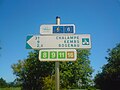 Signage for EuroVelo 6 in France near the tripoint of France, Switzerland and Germany

EuroVelo 7 – Sun Route
[edit]
EuroVelo 7 | |||||||||||||||||||||||||||||||||||||||||||||||||||||||||||||||||||||||||||||||||||||||||||||||||||||||||||||||||||||||||||||||||||||||||||||||||||||||||||||||||||||||||||||||||||||||||||||||||||||||||||||||||||||||||||||||||||||||||||||||||||||||||||||||||||
|---|---|---|---|---|---|---|---|---|---|---|---|---|---|---|---|---|---|---|---|---|---|---|---|---|---|---|---|---|---|---|---|---|---|---|---|---|---|---|---|---|---|---|---|---|---|---|---|---|---|---|---|---|---|---|---|---|---|---|---|---|---|---|---|---|---|---|---|---|---|---|---|---|---|---|---|---|---|---|---|---|---|---|---|---|---|---|---|---|---|---|---|---|---|---|---|---|---|---|---|---|---|---|---|---|---|---|---|---|---|---|---|---|---|---|---|---|---|---|---|---|---|---|---|---|---|---|---|---|---|---|---|---|---|---|---|---|---|---|---|---|---|---|---|---|---|---|---|---|---|---|---|---|---|---|---|---|---|---|---|---|---|---|---|---|---|---|---|---|---|---|---|---|---|---|---|---|---|---|---|---|---|---|---|---|---|---|---|---|---|---|---|---|---|---|---|---|---|---|---|---|---|---|---|---|---|---|---|---|---|---|---|---|---|---|---|---|---|---|---|---|---|---|---|---|---|---|---|---|---|---|---|---|---|---|---|---|---|---|---|---|---|---|---|---|---|---|---|---|---|---|---|---|---|---|---|---|---|---|---|
| |||||||||||||||||||||||||||||||||||||||||||||||||||||||||||||||||||||||||||||||||||||||||||||||||||||||||||||||||||||||||||||||||||||||||||||||||||||||||||||||||||||||||||||||||||||||||||||||||||||||||||||||||||||||||||||||||||||||||||||||||||||||||||||||||||
EV7 runs from the North Cape to Malta. It goes through Norway, Finland, Sweden, Denmark, Germany, the Czech Republic, Austria, Italy, and Malta.[10]
EuroVelo 8 – Mediterranean Route
[edit]
EuroVelo 8 | |||||||||||||||||||||||||||||||||||||||||||||||||||||||||||||||||||||||||||||||||||||||||||||||||||||||||||||||||||||||||||||||||||||||||||||||||||||||||||||||||||||||||||||||||||||||||||||||||||||||||||||||||||||||||||||||||||||||||||||||||||||||||||||||||||||||||||||||||||||||||||||||||||||||||||||||||||||||||||||||||||||||||||
|---|---|---|---|---|---|---|---|---|---|---|---|---|---|---|---|---|---|---|---|---|---|---|---|---|---|---|---|---|---|---|---|---|---|---|---|---|---|---|---|---|---|---|---|---|---|---|---|---|---|---|---|---|---|---|---|---|---|---|---|---|---|---|---|---|---|---|---|---|---|---|---|---|---|---|---|---|---|---|---|---|---|---|---|---|---|---|---|---|---|---|---|---|---|---|---|---|---|---|---|---|---|---|---|---|---|---|---|---|---|---|---|---|---|---|---|---|---|---|---|---|---|---|---|---|---|---|---|---|---|---|---|---|---|---|---|---|---|---|---|---|---|---|---|---|---|---|---|---|---|---|---|---|---|---|---|---|---|---|---|---|---|---|---|---|---|---|---|---|---|---|---|---|---|---|---|---|---|---|---|---|---|---|---|---|---|---|---|---|---|---|---|---|---|---|---|---|---|---|---|---|---|---|---|---|---|---|---|---|---|---|---|---|---|---|---|---|---|---|---|---|---|---|---|---|---|---|---|---|---|---|---|---|---|---|---|---|---|---|---|---|---|---|---|---|---|---|---|---|---|---|---|---|---|---|---|---|---|---|---|---|---|---|---|---|---|---|---|---|---|---|---|---|---|---|---|---|---|---|---|---|---|---|---|---|---|---|---|---|---|---|---|---|---|---|---|---|---|---|---|---|---|---|---|---|---|---|---|---|---|---|---|---|---|---|---|---|---|---|---|---|---|---|---|---|---|---|---|---|---|---|---|
| |||||||||||||||||||||||||||||||||||||||||||||||||||||||||||||||||||||||||||||||||||||||||||||||||||||||||||||||||||||||||||||||||||||||||||||||||||||||||||||||||||||||||||||||||||||||||||||||||||||||||||||||||||||||||||||||||||||||||||||||||||||||||||||||||||||||||||||||||||||||||||||||||||||||||||||||||||||||||||||||||||||||||||
EV8 follows the European coastline of the Mediterranean sea from Cádiz, Spain to Athens, Greece, going through Spain, France, Italy, Slovenia, Croatia, Bosnia and Herzegovina, Montenegro, Albania, Greece, Turkey, and Cyprus.[11][12]
EuroVelo 9 – Amber Route
[edit]
EuroVelo 9 | ||||||||||||||||||||||||||||||||||||||||||||||||||||||||||||||||||||||||||||||||||||||||||||||||||||||||||||||||||||||||||||||||||||||||||||||||||||||||||
|---|---|---|---|---|---|---|---|---|---|---|---|---|---|---|---|---|---|---|---|---|---|---|---|---|---|---|---|---|---|---|---|---|---|---|---|---|---|---|---|---|---|---|---|---|---|---|---|---|---|---|---|---|---|---|---|---|---|---|---|---|---|---|---|---|---|---|---|---|---|---|---|---|---|---|---|---|---|---|---|---|---|---|---|---|---|---|---|---|---|---|---|---|---|---|---|---|---|---|---|---|---|---|---|---|---|---|---|---|---|---|---|---|---|---|---|---|---|---|---|---|---|---|---|---|---|---|---|---|---|---|---|---|---|---|---|---|---|---|---|---|---|---|---|---|---|---|---|---|---|---|---|---|---|---|
| ||||||||||||||||||||||||||||||||||||||||||||||||||||||||||||||||||||||||||||||||||||||||||||||||||||||||||||||||||||||||||||||||||||||||||||||||||||||||||
EV9 (in Poland, also labeled as R9) stretches from the Baltic Sea to the Adriatic Sea. It is so named after the precious stone amber collected in the Baltic, which was taken by routes such as this to the Mediterranean. One of the shortest of the EuroVelo routes, EV9 still manages to cut across Europe from north to south, from Poland to Croatia, and in doing so passes through the Czech Republic, Austria and Slovenia en route.[13][14][15]
-
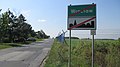 Sign R9 at the south-western border of Wrocław, near Wrocław Airport
 -
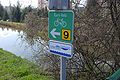 Signage for EuroVelo 9, Wiener Neustadt, Austria


EuroVelo 10 – Baltic Route
[edit]EuroVelo 10 | ||||||||||||||||||||||||||||||||||||||||||||||||||||||||||||||||||||||||||||||||||||||||||||||||||||||||||||||||||||||||||||||||||||||||||||||||||||||||||||||||||||||||||||||||||||||||||||||||||||||||||||||||||||||||||||||||||||||||||||||||||||||||||||||||||||||||||||||||||||||||||||||||||||||||||||||
|---|---|---|---|---|---|---|---|---|---|---|---|---|---|---|---|---|---|---|---|---|---|---|---|---|---|---|---|---|---|---|---|---|---|---|---|---|---|---|---|---|---|---|---|---|---|---|---|---|---|---|---|---|---|---|---|---|---|---|---|---|---|---|---|---|---|---|---|---|---|---|---|---|---|---|---|---|---|---|---|---|---|---|---|---|---|---|---|---|---|---|---|---|---|---|---|---|---|---|---|---|---|---|---|---|---|---|---|---|---|---|---|---|---|---|---|---|---|---|---|---|---|---|---|---|---|---|---|---|---|---|---|---|---|---|---|---|---|---|---|---|---|---|---|---|---|---|---|---|---|---|---|---|---|---|---|---|---|---|---|---|---|---|---|---|---|---|---|---|---|---|---|---|---|---|---|---|---|---|---|---|---|---|---|---|---|---|---|---|---|---|---|---|---|---|---|---|---|---|---|---|---|---|---|---|---|---|---|---|---|---|---|---|---|---|---|---|---|---|---|---|---|---|---|---|---|---|---|---|---|---|---|---|---|---|---|---|---|---|---|---|---|---|---|---|---|---|---|---|---|---|---|---|---|---|---|---|---|---|---|---|---|---|---|---|---|---|---|---|---|---|---|---|---|---|---|---|---|---|---|---|---|---|---|---|---|---|---|---|---|---|---|---|---|---|---|---|---|---|---|---|---|---|
| ||||||||||||||||||||||||||||||||||||||||||||||||||||||||||||||||||||||||||||||||||||||||||||||||||||||||||||||||||||||||||||||||||||||||||||||||||||||||||||||||||||||||||||||||||||||||||||||||||||||||||||||||||||||||||||||||||||||||||||||||||||||||||||||||||||||||||||||||||||||||||||||||||||||||||||||
EV10 runs around Baltic Sea. Some of its parts are mapped on OpenStreetMap project Relation: EuroVelo 10 - Baltic Sea Cycle Route - part Sweden (63584). On the state of the route there is an OpenStreetMap wiki page [16]
EuroVelo 11 – East Europe Route
[edit]
EV11 connects (theoretically) Norway's North Cape with Athens.
EuroVelo 12 – North Sea Route
[edit]
EuroVelo 12 | ||||||||||||||||||||||||||||||||||||||||||||||||||||||||||||||||||||||||||||||||||||||||||||||||||||||||||||||||||||||||||||||||||||||||||||||||||||||||||||||||||||||||||||||||||||||||||||||||||||||||||||||||||||||||||||||
|---|---|---|---|---|---|---|---|---|---|---|---|---|---|---|---|---|---|---|---|---|---|---|---|---|---|---|---|---|---|---|---|---|---|---|---|---|---|---|---|---|---|---|---|---|---|---|---|---|---|---|---|---|---|---|---|---|---|---|---|---|---|---|---|---|---|---|---|---|---|---|---|---|---|---|---|---|---|---|---|---|---|---|---|---|---|---|---|---|---|---|---|---|---|---|---|---|---|---|---|---|---|---|---|---|---|---|---|---|---|---|---|---|---|---|---|---|---|---|---|---|---|---|---|---|---|---|---|---|---|---|---|---|---|---|---|---|---|---|---|---|---|---|---|---|---|---|---|---|---|---|---|---|---|---|---|---|---|---|---|---|---|---|---|---|---|---|---|---|---|---|---|---|---|---|---|---|---|---|---|---|---|---|---|---|---|---|---|---|---|---|---|---|---|---|---|---|---|---|---|---|---|---|---|---|---|---|---|---|---|---|---|---|---|---|---|---|---|---|---|---|---|---|
| ||||||||||||||||||||||||||||||||||||||||||||||||||||||||||||||||||||||||||||||||||||||||||||||||||||||||||||||||||||||||||||||||||||||||||||||||||||||||||||||||||||||||||||||||||||||||||||||||||||||||||||||||||||||||||||||
EV12 was the first European route, opened in June 2001, 6,000 km (3,700 mi) route through England, Scotland, Norway, Sweden, Denmark, Germany, the Netherlands and Belgium. It features in the Guinness Book of Records as the longest unbroken signposted cycling route. It was funded in part by the European Union's Interreg initiative.
EuroVelo 13 – Iron Curtain Trail
[edit]EuV13 follows the old Iron Curtain, the divided borders of Europe during the Cold War.[17] The ICT runs from Kirkenes, Norway on the Barents Sea, along the Finno-Russian border through to the Baltic Sea, then hugs the length of the Baltic coast to Lübeck in Germany. It then follows the old border between West Germany and the former East Germany, the current borders between the Czech Republic and both Germany then Austria, the Austrian-Slovak and Austrian-Hungarian borders before following the borders of Romania, the former Yugoslavia, Bulgaria and North Macedonia.[18] It finishes at Rezovo in Bulgaria on the Black Sea after following the border with Greece and Turkey.[19]
EuroVelo 15 – The Rhine Cycle Route
[edit]EuroVelo 15 | ||||||||||||||||||||||||||||||||||||||||||||||||||||||||||||||||||||||||||||||||||||||||||||||||||||||||||||||||||||||||||||||||||||||||||||||||||||||
|---|---|---|---|---|---|---|---|---|---|---|---|---|---|---|---|---|---|---|---|---|---|---|---|---|---|---|---|---|---|---|---|---|---|---|---|---|---|---|---|---|---|---|---|---|---|---|---|---|---|---|---|---|---|---|---|---|---|---|---|---|---|---|---|---|---|---|---|---|---|---|---|---|---|---|---|---|---|---|---|---|---|---|---|---|---|---|---|---|---|---|---|---|---|---|---|---|---|---|---|---|---|---|---|---|---|---|---|---|---|---|---|---|---|---|---|---|---|---|---|---|---|---|---|---|---|---|---|---|---|---|---|---|---|---|---|---|---|---|---|---|---|---|---|---|---|---|---|---|---|---|
| ||||||||||||||||||||||||||||||||||||||||||||||||||||||||||||||||||||||||||||||||||||||||||||||||||||||||||||||||||||||||||||||||||||||||||||||||||||||
EV15, with an overall length of about 1,320 km (820 mi) passes through four countries from the headwaters of the Rhine in Andermatt in the Swiss Alps to the estuary in Rotterdam in the Netherlands, via France [20] and Germany.
EuroVelo 17 – Rhone Cycle Route
[edit]EuroVelo 17 | ||||||||||||||||||||||||||||||||||||||||||||||||||||||||||||||||||||||||||||||||||||||||||||||||||||||||||||||||||||||
|---|---|---|---|---|---|---|---|---|---|---|---|---|---|---|---|---|---|---|---|---|---|---|---|---|---|---|---|---|---|---|---|---|---|---|---|---|---|---|---|---|---|---|---|---|---|---|---|---|---|---|---|---|---|---|---|---|---|---|---|---|---|---|---|---|---|---|---|---|---|---|---|---|---|---|---|---|---|---|---|---|---|---|---|---|---|---|---|---|---|---|---|---|---|---|---|---|---|---|---|---|---|---|---|---|---|---|---|---|---|---|---|---|---|---|---|---|---|---|
| ||||||||||||||||||||||||||||||||||||||||||||||||||||||||||||||||||||||||||||||||||||||||||||||||||||||||||||||||||||||
EV17 has an overall length of about 1,250 km (780 mi).[21] It starts in Andermatt and runs along each side of Lake Geneva before crossing into France. Passing through Lyon and Avignon, it forks into sections which end in Montpellier and Marseille.
EuroVelo 19 – Meuse Cycle Route
[edit]EV19, with an overall length of about 1,050 km (650 mi), is the newest and the shortest EuroVelo route.[22] It follows one of the most significant rivers in Europe, from the source of the Meuse on the Langres plateau in France, heading north into Belgium and on to the river mouth at Hook of Holland, with the route ending in the Dutch port city of Rotterdam.
Requirements
[edit]The ECF has written a route development manual for those working on developing EuroVelo routes.[23] According to the guidelines, all EuroVelo routes should fulfill the following criteria:
- They must be based on existing or planned national or regional routes of the involved countries.
- At least two countries must be involved.
- Route length must be at least 1,000 km (620 mi).
- Steep sections should be avoided wherever possible and for very steep sections (if unavoidable) alternative transport options (i.e. public transport or alternative routes) should be provided.[24]
- Easy to communicate - internationally recognisable identity and name (marketing potential).
- Implementation plans in place (project plan, business plan, partners).
- Signing in accordance with the regulations of the respective nations and/or regions, continuous and in both directions.
- Signage supplemented by EuroVelo route information panels, in accordance with the recommendations of UNECE and the ECF's Signing of EuroVelo cycle routes manual.
Route infrastructure
[edit]In 2011 the share of route infrastructure components in the EuroVelo network was as follows:[25]
- Bicycle path/lane: 14%
- Traffic-free asphalted road: 8%
- Traffic-free non-asphalted road: 6%
- Public low-traffic, asphalted road: 56%
- Public non-asphalted road: 3%
- Public high-traffic, asphalted road: 14%
See also
[edit]References
[edit]- ^ "EuroVelo - the European cycle route network". EuroVelo.org website. Retrieved 9 December 2013.
- ^ "Routes". EuroVelo. ECF. Archived from the original on 4 August 2012. Retrieved 23 January 2012.
- ^ "Projects and networks - EuroVelo". ECF. 14 December 2015. Retrieved 2 August 2016.
- ^ Richard Peace (2008-09-17). "Euros for EuroVelo". bikeradar.com. Future Publishing. Archived from the original on 2009-03-09. Retrieved 2009-12-21.
- ^ "History - EuroVelo - the European cycle route network". EuroVelo website. European Cyclists' Federation. Archived from the original on 6 June 2017. Retrieved 17 November 2013.
- ^ ECF. "The Iberian Cycle Route is set to become the future EuroVelo 16". EuroVelo. Retrieved 2023-11-08.
- ^ "EuroVelo 1". EuroVelo.com website. European Cyclists' Federation. Retrieved 29 December 2013.
- ^ "The Complete Route". Euroroute R1 website. Archived from the original on 29 November 2021. Retrieved 7 January 2014.
- ^ "L'itinéraire vélo de Bâle à l'Atlantique — EuroVelo 6". Retrieved 11 November 2016.
- ^ "EuroVelo 7". EuroVelo.com. Retrieved 26 December 2013.
- ^ "EuroVelo 8". EuroVelo.com website. European Cyclists' Federation. Retrieved 5 January 2014.
- ^ "EuroVelo 8 - Mediterranean Route". Retrieved 11 November 2016.
- ^ "EuroVelo 9". EuroVelo.com website. European Cyclists' Federation. Retrieved 3 January 2014.
- ^ "Eurovelo 9". 18 September 2011. Retrieved 11 November 2016.
- ^ "Radrouten Niederösterreich - EuroVelo 9". Archived from the original on August 18, 2004.
- ^ "EV10 - OpenStreetMap Wiki". Retrieved 11 November 2016.
- ^ "ECF - EuroVelo - The Iron Curtain Trail (EuroVelo 13)".
- ^ "- Eurovelo 13". Retrieved 11 November 2016.
- ^ "Iron Curtain Trail - The Iron Curtain Trail - experiencing the history of Europe's division". Retrieved 11 November 2016.
- ^ "via France" (PDF). Archived from the original (PDF) on 2012-03-18. Retrieved 2011-07-27.
- ^ "Cycling tourism: Rhone cycle route". EuroVelo.
- ^ "EuroVelo 19 | Meuse Cycle Route". EuroVelo.
- ^ http://www.eurovelo.org/wp-content/uploads/2011/08/Guidance-on-the-Route-Development-Process.pdf Archived 2013-06-30 at the Wayback Machine EuroVelo: Guidance on the Route Development Process
- ^ "Guidance on the Route Development Process" (PDF). EuroVelo for Professionals. European Cyclists' Federation. Retrieved 11 November 2023.
- ^ "EuroVelo the European cycle route network Development Strategy 2012-2020" (PDF). EuroVelo.org website. European Cyclists' Federation. December 2011. Retrieved 19 December 2013.
External links
[edit]- EuroVelo — the European Cycle Route Network
- ECF European Cyclists' Federation
- Eurovelo 13: Iron Curtain Trail - Through Europe along the former Iron Curtain
- Eurovelo 15 from Andermatt to Rotterdam
- Mapping project of EuroVelo on OpenStreetMap
- Italian Greenways
- Interactive map
Mobile Apps
[edit]- Iphone App EuroCycle - Offline Maps for EuroVelo Cycle Routes
| International | |
|---|---|
| National | |