
Community hub
Recent from talks
Contribute something
Nothing was collected or created yet.
Astronomical coordinate systems
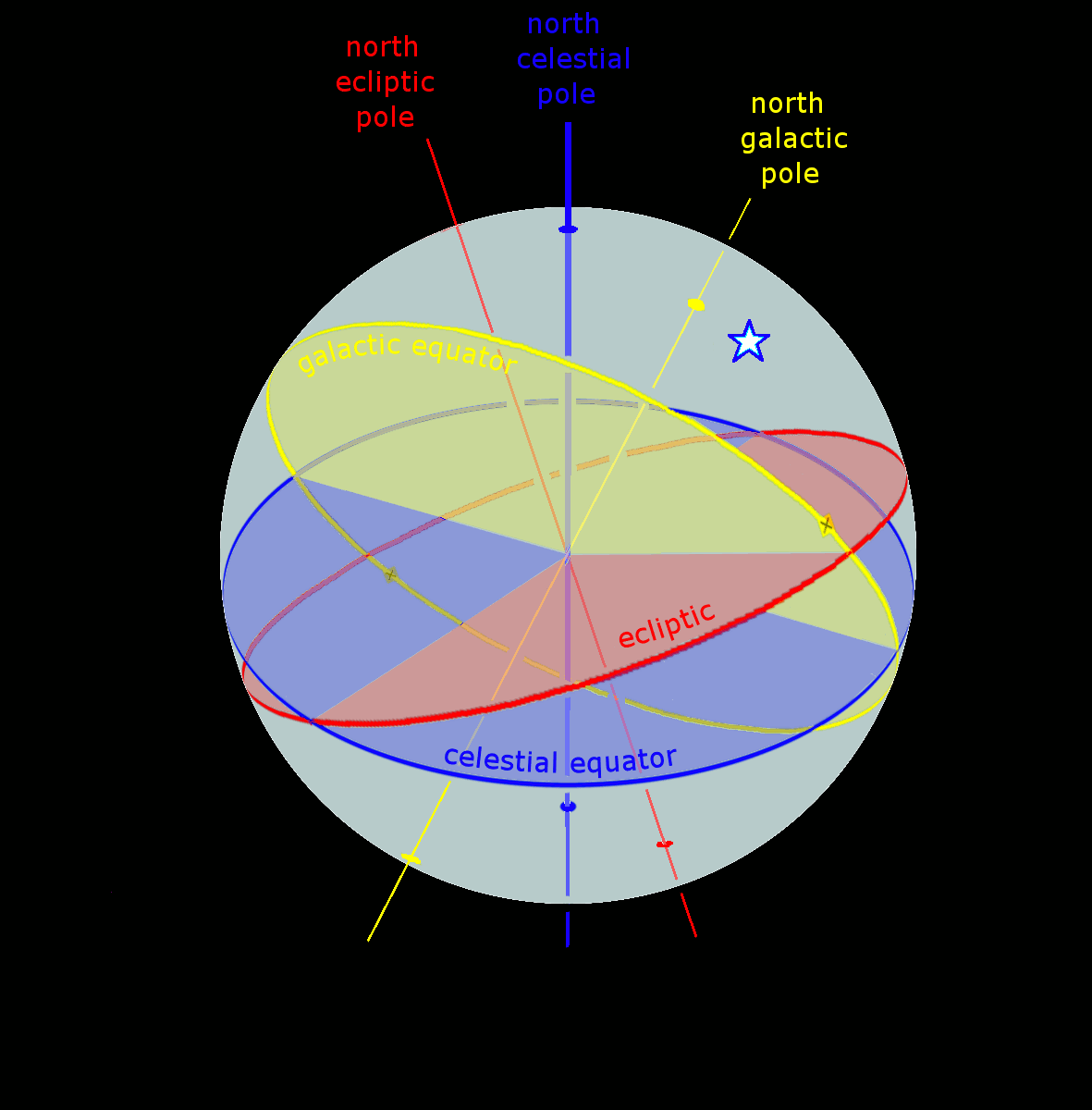
View on Wikipedia A star's galactic, ecliptic, and equatorial coordinates, as projected on the celestial sphere. Ecliptic and equatorial coordinates share the March equinox as the primary direction, and galactic coordinates are referred to the galactic center. The origin of coordinates (the "center of the sphere") is ambiguous; see celestial sphere for more information. |
In astronomy, coordinate systems are used for specifying positions of celestial objects (satellites, planets, stars, galaxies, etc.) relative to a given reference frame, based on physical reference points available to a situated observer (e.g. the true horizon and north to an observer on Earth's surface).[1] Coordinate systems in astronomy can specify an object's relative position in three-dimensional space or plot merely by its direction on a celestial sphere, if the object's distance is unknown or trivial.
Spherical coordinates, projected on the celestial sphere, are analogous to the geographic coordinate system used on the surface of Earth. These differ in their choice of fundamental plane, which divides the celestial sphere into two equal hemispheres along a great circle. Rectangular coordinates, in appropriate units, have the same fundamental (x, y) plane and primary (x-axis) direction, such as an axis of rotation. Each coordinate system is named after its choice of fundamental plane.
Coordinate systems
[edit]The following table lists the common coordinate systems in use by the astronomical community. The fundamental plane divides the celestial sphere into two equal hemispheres and defines the baseline for the latitudinal coordinates, similar to the equator in the geographic coordinate system. The poles are located at ±90° from the fundamental plane. The primary direction is the starting point of the longitudinal coordinates. The origin is the zero distance point, the "center of the celestial sphere", although the definition of celestial sphere is ambiguous about the definition of its center point.
| Coordinate system[2] | Center point (origin) |
Fundamental plane (0° latitude) |
Poles | Coordinates | Primary direction (0° longitude) | |
|---|---|---|---|---|---|---|
| Latitude | Longitude | |||||
| Horizontal (also called alt-az or el-az) | Observer | Horizon | Zenith, nadir | Altitude (a) or elevation | Azimuth (A) | North or south point of horizon |
| Equatorial | Center of the Earth (geocentric), or Sun (heliocentric) | Celestial equator | Celestial poles | Declination (δ) | Right ascension (α) or hour angle (h) |
March equinox |
| Ecliptic | Ecliptic | Ecliptic poles | Ecliptic latitude (β) | Ecliptic longitude (λ) | ||
| Galactic | Center of the Sun | Galactic plane | Galactic poles | Galactic latitude (b) | Galactic longitude (l) | Galactic Center |
| Supergalactic | Supergalactic plane | Supergalactic poles | Supergalactic latitude (SGB) | Supergalactic longitude (SGL) | Intersection of supergalactic plane and galactic plane | |
Horizontal system
[edit]
The horizontal, or altitude-azimuth, system is based on the position of the observer on Earth, which revolves around its own axis once per sidereal day (23 hours, 56 minutes and 4.091 seconds) in relation to the star background. The positioning of a celestial object by the horizontal system varies with time, but is a useful coordinate system for locating and tracking objects for observers on Earth. It is based on the position of stars relative to an observer's ideal horizon.
Equatorial system
[edit]The equatorial coordinate system is centered at Earth's center, but fixed relative to the celestial poles and the March equinox. The coordinates are based on the location of stars relative to Earth's equator if it were projected out to an infinite distance. The equatorial describes the sky as seen from the Solar System, and modern star maps almost exclusively use equatorial coordinates.
The equatorial system is the normal coordinate system for most professional and many amateur astronomers having an equatorial mount that follows the movement of the sky during the night. Celestial objects are found by adjusting the telescope's or other instrument's scales so that they match the equatorial coordinates of the selected object to observe.
Popular choices of pole and equator are the older B1950 and the modern J2000 systems, but a pole and equator "of date" can also be used, meaning one appropriate to the date under consideration, such as when a measurement of the position of a planet or spacecraft is made. There are also subdivisions into "mean of date" coordinates, which average out or ignore nutation, and "true of date," which include nutation.
Ecliptic system
[edit]The fundamental plane is the plane of the Earth's orbit, called the ecliptic plane. There are two principal variants of the ecliptic coordinate system: geocentric ecliptic coordinates centered on the Earth and heliocentric ecliptic coordinates centered on the center of mass of the Solar System.
The geocentric ecliptic system was the principal coordinate system for ancient astronomy and is still useful for computing the apparent motions of the Sun, Moon, and planets.[3] It was used to define the twelve astrological signs of the zodiac, for instance.
The heliocentric ecliptic system describes the planets' orbital movement around the Sun, and centers on the barycenter of the Solar System (i.e. very close to the center of the Sun). The system is primarily used for computing the positions of planets and other Solar System bodies, as well as defining their orbital elements.
Galactic system
[edit]The galactic coordinate system uses the approximate plane of the Milky Way Galaxy as its fundamental plane. The Solar System is still the center of the coordinate system, and the zero point is defined as the direction towards the Galactic Center. Galactic latitude resembles the elevation above the galactic plane and galactic longitude determines direction relative to the center of the galaxy.
Supergalactic system
[edit]The supergalactic coordinate system corresponds to a fundamental plane that contains a higher than average number of local galaxies in the sky as seen from Earth.
Converting coordinates
[edit]Conversions between the various coordinate systems are given.[4] See the notes before using these equations.
Notation
[edit]- Horizontal coordinates
- Equatorial coordinates
- α, right ascension
- δ, declination
- h, hour angle
- Ecliptic coordinates
- Galactic coordinates
- Miscellaneous
- λo, observer's longitude
- ϕo, observer's latitude
- ε, obliquity of the ecliptic (about 23.4°)
- θL, local sidereal time
- θG, Greenwich sidereal time
Hour angle ↔ right ascension
[edit]
Equatorial ↔ ecliptic
[edit]The classical equations, derived from spherical trigonometry, for the longitudinal coordinate are presented to the right of a bracket; dividing the first equation by the second gives the convenient tangent equation seen on the left.[5] The rotation matrix equivalent is given beneath each case.[6] This division is ambiguous because tan has a period of 180° (π) whereas cos and sin have periods of 360° (2π).
![{\displaystyle {\begin{aligned}\tan \left(\lambda \right)&={\sin \left(\alpha \right)\cos \left(\varepsilon \right)+\tan \left(\delta \right)\sin \left(\varepsilon \right) \over \cos \left(\alpha \right)};\qquad {\begin{cases}\cos \left(\beta \right)\sin \left(\lambda \right)=\cos \left(\delta \right)\sin \left(\alpha \right)\cos \left(\varepsilon \right)+\sin \left(\delta \right)\sin \left(\varepsilon \right);\\\cos \left(\beta \right)\cos \left(\lambda \right)=\cos \left(\delta \right)\cos \left(\alpha \right).\end{cases}}\\\sin \left(\beta \right)&=\sin \left(\delta \right)\cos \left(\varepsilon \right)-\cos \left(\delta \right)\sin \left(\varepsilon \right)\sin \left(\alpha \right)\\[3pt]{\begin{bmatrix}\cos \left(\beta \right)\cos \left(\lambda \right)\\\cos \left(\beta \right)\sin \left(\lambda \right)\\\sin \left(\beta \right)\end{bmatrix}}&={\begin{bmatrix}1&0&0\\0&\cos \left(\varepsilon \right)&\sin \left(\varepsilon \right)\\0&-\sin \left(\varepsilon \right)&\cos \left(\varepsilon \right)\end{bmatrix}}{\begin{bmatrix}\cos \left(\delta \right)\cos \left(\alpha \right)\\\cos \left(\delta \right)\sin \left(\alpha \right)\\\sin \left(\delta \right)\end{bmatrix}}\\[6pt]\tan \left(\alpha \right)&={\sin \left(\lambda \right)\cos \left(\varepsilon \right)-\tan \left(\beta \right)\sin \left(\varepsilon \right) \over \cos \left(\lambda \right)};\qquad {\begin{cases}\cos \left(\delta \right)\sin \left(\alpha \right)=\cos \left(\beta \right)\sin \left(\lambda \right)\cos \left(\varepsilon \right)-\sin \left(\beta \right)\sin \left(\varepsilon \right);\\\cos \left(\delta \right)\cos \left(\alpha \right)=\cos \left(\beta \right)\cos \left(\lambda \right).\end{cases}}\\[3pt]\sin \left(\delta \right)&=\sin \left(\beta \right)\cos \left(\varepsilon \right)+\cos \left(\beta \right)\sin \left(\varepsilon \right)\sin \left(\lambda \right).\\[6pt]{\begin{bmatrix}\cos \left(\delta \right)\cos \left(\alpha \right)\\\cos \left(\delta \right)\sin \left(\alpha \right)\\\sin \left(\delta \right)\end{bmatrix}}&={\begin{bmatrix}1&0&0\\0&\cos \left(\varepsilon \right)&-\sin \left(\varepsilon \right)\\0&\sin \left(\varepsilon \right)&\cos \left(\varepsilon \right)\end{bmatrix}}{\begin{bmatrix}\cos \left(\beta \right)\cos \left(\lambda \right)\\\cos \left(\beta \right)\sin \left(\lambda \right)\\\sin \left(\beta \right)\end{bmatrix}}.\end{aligned}}}](https://wikimedia.org/api/rest_v1/media/math/render/svg/32e64f7f6ef1f8a0eda9cf775fa41f0023c54d4d)
Equatorial ↔ horizontal
[edit]Azimuth (A) is measured from the south point, turning positive to the west.[7] Zenith distance, the angular distance along the great circle from the zenith to a celestial object, is simply the complementary angle of the altitude: 90° − a.[8]
![{\displaystyle {\begin{aligned}\tan \left(A\right)&={\sin \left(h\right) \over \cos \left(h\right)\sin \left(\phi _{\text{o}}\right)-\tan \left(\delta \right)\cos \left(\phi _{\text{o}}\right)};\qquad {\begin{cases}\cos \left(a\right)\sin \left(A\right)=\cos \left(\delta \right)\sin \left(h\right);\\\cos \left(a\right)\cos \left(A\right)=\cos \left(\delta \right)\cos \left(h\right)\sin \left(\phi _{\text{o}}\right)-\sin \left(\delta \right)\cos \left(\phi _{\text{o}}\right)\end{cases}}\\[3pt]\sin \left(a\right)&=\sin \left(\phi _{\text{o}}\right)\sin \left(\delta \right)+\cos \left(\phi _{\text{o}}\right)\cos \left(\delta \right)\cos \left(h\right);\end{aligned}}}](https://wikimedia.org/api/rest_v1/media/math/render/svg/24591754e1a4d05bbcb52fd2b752ad2fa281ad42)
In solving the tan(A) equation for A, in order to avoid the ambiguity of the arctangent, use of the two-argument arctangent, denoted atan2(x,y), is recommended. The two-argument arctangent computes the arctangent of y/x, and accounts for the quadrant in which it is being computed. Thus, consistent with the convention of azimuth being measured from the south and opening positive to the west,
- ,

where
- .

If the above formula produces a negative value for A, it can be rendered positive by simply adding 360°.
![{\displaystyle {\begin{aligned}{\begin{bmatrix}\cos \left(a\right)\cos \left(A\right)\\\cos \left(a\right)\sin \left(A\right)\\\sin \left(a\right)\end{bmatrix}}&={\begin{bmatrix}\sin \left(\phi _{\text{o}}\right)&0&-\cos \left(\phi _{\text{o}}\right)\\0&1&0\\\cos \left(\phi _{\text{o}}\right)&0&\sin \left(\phi _{\text{o}}\right)\end{bmatrix}}{\begin{bmatrix}\cos \left(\delta \right)\cos \left(h\right)\\\cos \left(\delta \right)\sin \left(h\right)\\\sin \left(\delta \right)\end{bmatrix}}\\&={\begin{bmatrix}\sin \left(\phi _{\text{o}}\right)&0&-\cos \left(\phi _{\text{o}}\right)\\0&1&0\\\cos \left(\phi _{\text{o}}\right)&0&\sin \left(\phi _{\text{o}}\right)\end{bmatrix}}{\begin{bmatrix}\cos \left(\theta _{L}\right)&\sin \left(\theta _{L}\right)&0\\\sin \left(\theta _{L}\right)&-\cos \left(\theta _{L}\right)&0\\0&0&1\end{bmatrix}}{\begin{bmatrix}\cos \left(\delta \right)\cos \left(\alpha \right)\\\cos \left(\delta \right)\sin \left(\alpha \right)\\\sin \left(\delta \right)\end{bmatrix}};\\[6pt]\tan \left(h\right)&={\sin \left(A\right) \over \cos \left(A\right)\sin \left(\phi _{\text{o}}\right)+\tan \left(a\right)\cos \left(\phi _{\text{o}}\right)};\qquad {\begin{cases}\cos \left(\delta \right)\sin \left(h\right)=\cos \left(a\right)\sin \left(A\right);\\\cos \left(\delta \right)\cos \left(h\right)=\sin \left(a\right)\cos \left(\phi _{\text{o}}\right)+\cos \left(a\right)\cos \left(A\right)\sin \left(\phi _{\text{o}}\right)\end{cases}}\\[3pt]\sin \left(\delta \right)&=\sin \left(\phi _{\text{o}}\right)\sin \left(a\right)-\cos \left(\phi _{\text{o}}\right)\cos \left(a\right)\cos \left(A\right);\end{aligned}}}](https://wikimedia.org/api/rest_v1/media/math/render/svg/d0b38b9e388153fa974a286f72be3bf6906a5fe3)
Again, in solving the tan(h) equation for h, use of the two-argument arctangent that accounts for the quadrant is recommended. Thus, again consistent with the convention of azimuth being measured from the south and opening positive to the west,
- ,

where
![{\displaystyle {\begin{aligned}x&=\sin \left(\phi _{\text{o}}\right)\cos \left(a\right)\cos \left(A\right)+\cos \left(\phi _{\text{o}}\right)\sin \left(a\right)\\y&=\cos \left(a\right)\sin \left(A\right)\\[3pt]{\begin{bmatrix}\cos \left(\delta \right)\cos \left(h\right)\\\cos \left(\delta \right)\sin \left(h\right)\\\sin \left(\delta \right)\end{bmatrix}}&={\begin{bmatrix}\sin \left(\phi _{\text{o}}\right)&0&\cos \left(\phi _{\text{o}}\right)\\0&1&0\\-\cos \left(\phi _{\text{o}}\right)&0&\sin \left(\phi _{\text{o}}\right)\end{bmatrix}}{\begin{bmatrix}\cos \left(a\right)\cos \left(A\right)\\\cos \left(a\right)\sin \left(A\right)\\\sin \left(a\right)\end{bmatrix}}\\{\begin{bmatrix}\cos \left(\delta \right)\cos \left(\alpha \right)\\\cos \left(\delta \right)\sin \left(\alpha \right)\\\sin \left(\delta \right)\end{bmatrix}}&={\begin{bmatrix}\cos \left(\theta _{L}\right)&\sin \left(\theta _{L}\right)&0\\\sin \left(\theta _{L}\right)&-\cos \left(\theta _{L}\right)&0\\0&0&1\end{bmatrix}}{\begin{bmatrix}\sin \left(\phi _{\text{o}}\right)&0&\cos \left(\phi _{\text{o}}\right)\\0&1&0\\-\cos \left(\phi _{\text{o}}\right)&0&\sin \left(\phi _{\text{o}}\right)\end{bmatrix}}{\begin{bmatrix}\cos \left(a\right)\cos \left(A\right)\\\cos \left(a\right)\sin \left(A\right)\\\sin \left(a\right)\end{bmatrix}}.\end{aligned}}}](https://wikimedia.org/api/rest_v1/media/math/render/svg/e80cd665d08444dadd652d53b0f1bfd9bb35e9c5)
Equatorial ↔ galactic
[edit]These equations[14] are for converting equatorial coordinates to Galactic coordinates.

are the equatorial coordinates of the North Galactic Pole and is the Galactic longitude of the North Celestial Pole. Referred to J2000.0 the values of these quantities are:


If the equatorial coordinates are referred to another equinox, they must be precessed to their place at J2000.0 before applying these formulae.
These equations convert to equatorial coordinates referred to B2000.0.

Notes on conversion
[edit]- Angles in the degrees ( ° ), minutes ( ′ ), and seconds ( ″ ) of sexagesimal measure must be converted to decimal before calculations are performed. Whether they are converted to decimal degrees or radians depends upon the particular calculating machine or program. Negative angles must be carefully handled; −10° 20′ 30″ must be converted as −10° −20′ −30″.
- Angles in the hours ( h ), minutes ( m ), and seconds ( s ) of time measure must be converted to decimal degrees or radians before calculations are performed. 1h = 15°; 1m = 15′; 1s = 15″
- Angles greater than 360° (2π) or less than 0° may need to be reduced to the range 0°–360° (0–2π) depending upon the particular calculating machine or program.
- The cosine of a latitude (declination, ecliptic and Galactic latitude, and altitude) are never negative by definition, since the latitude varies between −90° and +90°.
- Inverse trigonometric functions arcsine, arccosine and arctangent are quadrant-ambiguous, and results should be carefully evaluated. Use of the second arctangent function (denoted in computing as atn2(y,x) or atan2(y,x), which calculates the arctangent of y/x using the sign of both arguments to determine the right quadrant) is recommended when calculating longitude/right ascension/azimuth. An equation which finds the sine, followed by the arcsin function, is recommended when calculating latitude/declination/altitude.
- Azimuth (A) is referred here to the south point of the horizon, the common astronomical reckoning. An object on the meridian to the south of the observer has A = h = 0° with this usage. However, n Astropy's AltAz, in the Large Binocular Telescope FITS file convention, in XEphem, in the IAU library Standards of Fundamental Astronomy and Section B of the Astronomical Almanac for example, the azimuth is East of North. In navigation and some other disciplines, azimuth is figured from the north.
- The equations for altitude (a) do not account for atmospheric refraction.
- The equations for horizontal coordinates do not account for diurnal parallax, that is, the small offset in the position of a celestial object caused by the position of the observer on the Earth's surface. This effect is significant for the Moon, less so for the planets, minute for stars or more distant objects.
- Observer's longitude (λo) here is measured positively eastward from the prime meridian, accordingly to current IAU standards.
See also
[edit]- Apparent longitude
- Azimuth – Horizontal angle from north or other reference cardinal direction
- Barycentric and geocentric celestial reference systems – Celestial coordinate system
- Celestial sphere – Conceptual tool in astronomy
- International Celestial Reference System and its realizations – Current standard celestial reference system and frame
- Orbital elements – Parameters that define a specific orbit
- Planetary coordinate system – Coordinate system for planets
- Terrestrial reference frame – Reference frame for measuring location
Notes
[edit]- ^ Depending on the azimuth convention in use, the signs of cos A and sin A appear in all four different combinations. Karttunen et al.,[9] Taff,[10] and Roth[11] define A clockwise from the south. Lang[12] defines it north through east, Smart[13] north through west. Meeus (1991),[4] p. 89: sin δ = sin φ sin a − cos φ cos a cos A; Explanatory Supplement (1961),[5] p. 26: sin δ = sin a sin φ + cos a cos A cos φ.
References
[edit]- ^ Kanas, Nick (2021). "Star and Solar System Maps: A History of Celestial Cartography". Research Notes of the AAS. 5 (4). American Astronomical Society: 69. Bibcode:2021RNAAS...5...69K. doi:10.3847/2515-5172/abf35c. S2CID 233522547.
- ^ Majewski, Steve. "Coordinate Systems". UVa Department of Astronomy. Archived from the original on 12 March 2016. Retrieved 19 March 2011.
- ^ Aaboe, Asger. 2001 Episodes from the Early History of Astronomy. New York: Springer-Verlag., pp. 17–19.
- ^ a b Meeus, Jean (1991). Astronomical Algorithms. Willmann-Bell, Inc., Richmond, VA. ISBN 0-943396-35-2., chap. 12
- ^ a b U.S. Naval Observatory, Nautical Almanac Office; H.M. Nautical Almanac Office (1961). Explanatory Supplement to the Astronomical Ephemeris and the American Ephemeris and Nautical Almanac. H.M. Stationery Office, London., sec. 2A
- ^ U.S. Naval Observatory, Nautical Almanac Office (1992). P. Kenneth Seidelmann (ed.). Explanatory Supplement to the Astronomical Almanac. University Science Books, Mill Valley, CA. ISBN 0-935702-68-7., section 11.43
- ^ Montenbruck, Oliver; Pfleger, Thomas (2000). Astronomy on the Personal Computer. Springer-Verlag Berlin Heidelberg. ISBN 978-3-540-67221-0., pp 35-37
- ^ U.S. Naval Observatory, Nautical Almanac Office; U.K. Hydrographic Office, H.M. Nautical Almanac Office (2008). The Astronomical Almanac for the Year 2010. U.S. Govt. Printing Office. p. M18. ISBN 978-0160820083.
- ^ Karttunen, H.; Kröger, P.; Oja, H.; Poutanen, M.; Donner, H. J. (2006). Fundamental Astronomy (5 ed.). Springer. Bibcode:2003fuas.book.....K. ISBN 978-3-540-34143-7.
- ^ Taff, L. G. (1981). Computational spherical astronomy. Wiley. Bibcode:1981csa..book.....T. ISBN 0-471-06257-X.
- ^ Roth, G. D. (23 October 1989). Handbuch für Sternenfreunde. Springer. ISBN 3-540-19436-3.
- ^ Lang, Kenneth R. (1978). Astrophysical Formulae. Springer. Bibcode:1978afcp.book.....L. ISBN 3-540-09064-9.
- ^ Smart, William Marshall (1949). Text-book on spherical astronomy. Cambridge University Press. Bibcode:1965tbsa.book.....S.
- ^ Poleski, Radosław (2013). "Transformation of the equatorial proper motion to the Galactic system". arXiv:1306.2945 [astro-ph.IM].
External links
[edit]- NOVAS, the United States Naval Observatory's Vector Astrometry Software, an integrated package of subroutines and functions for computing various commonly needed quantities in positional astronomy.
- SuperNOVAS a maintained fork of NOVAS C 3.1 with bug fixes, improvements, new features, and online documentation.
- SOFA, the IAU's Standards of Fundamental Astronomy, an accessible and authoritative set of algorithms and procedures that implement standard models used in fundamental astronomy.
- This article was originally based on Jason Harris' Astroinfo, which is accompanied by KStars, a KDE Desktop Planetarium for Linux/KDE.
Gravitational orbits | |||||||||
|---|---|---|---|---|---|---|---|---|---|
| Types |
| ||||||||
| Parameters |
| ||||||||
| Maneuvers | |||||||||
| Orbital mechanics |
| ||||||||
Astronomical coordinate systems
View on GrokipediaFundamentals of Astronomical Coordinates
Definition and Historical Context
Astronomical coordinate systems provide frameworks for locating celestial objects on the imaginary celestial sphere, an infinite-radius construct centered on the observer or Earth, by specifying positions through pairs of angular coordinates relative to defined reference planes and origins. These systems are fundamental to astronomy, enabling precise pointing of telescopes, calculation of orbits for planets and spacecraft, and standardized archiving of observational data across global observatories to facilitate comparison and analysis. Founded on principles of spherical geometry, they translate three-dimensional positions into two-dimensional angular measures, accommodating the apparent fixed positions of distant stars while accounting for Earth's rotation and orbit. The origins of astronomical coordinate systems trace back to ancient civilizations, with the Babylonians developing systematic observations around 1000 BCE that introduced concepts akin to celestial longitude and latitude, serving as precursors to later ecliptic frameworks. In ancient Greece, Hipparchus advanced this tradition around 150 BCE by compiling the first known comprehensive star catalog of over 850 stars, employing equatorial-like coordinates based on the celestial equator to map stellar positions with accuracies approaching one degree. During the Islamic Golden Age, astronomers like Al-Battani (c. 858–929 CE) refined these methods through extensive observations spanning decades, improving trigonometric functions essential for spherical calculations and correcting earlier Greek values for parameters such as the solar year's length and equinox precession, which enhanced the precision of coordinate determinations. In the 20th century, the International Astronomical Union (IAU) played a pivotal role in standardizing these systems, adopting resolutions in the 1970s and 1980s that defined fundamental constants and reference frames, such as the FK5 catalog system in 1988, paving the way for the quasi-inertial International Celestial Reference System (ICRS) formalized in 1997–2000. Early challenges in historical catalogs stemmed from the absence of uniform reference frames, resulting in inconsistencies due to unmodeled effects like stellar precession and differences in observational epochs; for instance, Ptolemy's 2nd-century CE Almagest inherited and amplified errors from Hipparchus's work because of such discrepancies, complicating cross-era comparisons until modern corrections.Spherical Coordinate Basics
Spherical coordinates in astronomy specify the location of celestial objects on the celestial sphere using two orthogonal angular coordinates: typically a "latitude" measured perpendicular to a fundamental reference plane (ranging from -90° to +90°) and a "longitude" measured parallel to the plane from a reference meridian (ranging from 0° to 360°). These angles are defined relative to chosen poles and equators on the sphere, with the celestial sphere idealized as a unit sphere where radial distance is irrelevant for distant objects, and positions are given in angular units such as degrees (°), arcminutes ('), and arcseconds ("). Fundamental elements include the poles (intersections of the sphere with the reference axis), the equator (great circle equidistant from the poles), great circles (maximum circles dividing the sphere, serving as paths of shortest angular distance), and small circles (parallels offset from the equator). This framework, rooted in spherical trigonometry, allows for the computation of angular separations and transformations between different coordinate systems.[2]Celestial Sphere Coordinate Systems
Horizontal Coordinate System
The horizontal coordinate system, also known as the alt-azimuth or horizon system, is a local, observer-dependent framework in astronomy for locating celestial objects relative to the observer's immediate surroundings on Earth. It treats the sky as a hemisphere centered on the observer, providing a straightforward way to describe positions for real-time observations.[1][3] The two primary coordinates are altitude (h) and azimuth (A). Altitude measures the angular elevation of an object above the horizon, ranging from 0° at the horizon to 90° at the zenith (the point directly overhead), though it can extend to -90° for points below the horizon at the nadir. Azimuth is the horizontal angle from a reference direction, typically measured clockwise from true north (0°) through east (90°), south (180°), and west (270°), up to 360°.[1][3] In this system, the observer's horizon serves as the fundamental reference plane, analogous to an equator, while the zenith functions as the local equivalent of a north pole, with vertical circles radiating from the zenith to points on the horizon. The projection of the celestial equator onto this plane varies with the observer's latitude, influencing the altitude of equatorial objects.[1][3] This coordinate system offers key advantages for practical use, including its direct compatibility with alt-azimuth telescope mounts, which allow simple, symmetric mechanical pointing without the need for complex tracking gears, and its intuitive alignment with naked-eye viewing of the local sky. It is particularly suited for short-term observations, such as in radio astronomy arrays or amateur setups, where real-time positioning is prioritized over fixed referencing.[1] Despite these benefits, the horizontal system has notable limitations: it is inherently tied to the observer's geographic location and the time of observation, causing coordinates to shift continuously due to Earth's rotation and to differ between observers at varying latitudes or longitudes, which renders it impractical for cataloging or comparing positions across global sites.[3]Equatorial Coordinate System
The equatorial coordinate system is a celestial coordinate framework aligned with Earth's rotational axis, projecting the plane of the terrestrial equator onto the celestial sphere to form the celestial equator. This system provides a fixed, global reference for locating astronomical objects, independent of an observer's location on Earth, and serves as the standard for most modern astronomical observations and catalogs.[1] In this system, positions are specified using two angular coordinates: right ascension (α), measured eastward along the celestial equator from the vernal equinox, and declination (δ), measured north or south from the celestial equator. Right ascension is typically expressed in hours, minutes, and seconds (ranging from 0^h to 24^h, equivalent to 0° to 360°), reflecting the Earth's rotation, while declination is given in degrees from -90° (south celestial pole) to +90° (north celestial pole). The vernal equinox, where the ecliptic intersects the celestial equator at the Sun's position during the March equinox, defines the origin for right ascension (α = 0^h).[1] Due to the gradual precession of Earth's rotational axis, which shifts the orientation of the celestial equator and equinox over time, equatorial coordinates must be specified for a particular epoch, such as J2000.0 (corresponding to January 1, 2000, at 12:00 Terrestrial Time). This epoch-based definition ensures consistency in referencing positions, with the International Celestial Reference System (ICRS) providing a quasi-inertial frame closely aligned with J2000.0 for high-precision applications.[4] The equatorial system forms the basis for star atlases, telescope pointing, and major deep-sky surveys, exemplified by the Hipparcos catalog, which provides astrometric data for over 118,000 stars in equatorial coordinates at epoch J1991.25, often transformed to J2000.0 for broader use in galactic structure studies and navigation.[5][6]Ecliptic Coordinate System
The ecliptic coordinate system is a celestial reference frame oriented to the ecliptic plane, defined as the apparent path of the Sun around the Earth or, equivalently, the plane of Earth's orbit around the Sun. This system provides a natural framework for tracking objects whose motions are confined near this plane, with the vernal equinox serving as the primary reference point where the ecliptic intersects the celestial equator.[1][7] Positions in the ecliptic system are specified by two angular coordinates: ecliptic longitude (λ) and ecliptic latitude (β). Ecliptic longitude measures the angular distance eastward along the ecliptic from the vernal equinox to the point in question, spanning 0° to 360°. Ecliptic latitude measures the angular deviation perpendicular to the ecliptic plane, positive northward and negative southward, ranging from -90° to +90°. The north ecliptic pole, located at β = 90° (in the constellation Draco), represents the zenith direction perpendicular to the ecliptic plane, while the ecliptic equator corresponds to the zero-latitude great circle that traces the Sun's annual path. The ecliptic plane is inclined to the celestial equator by the obliquity of the ecliptic, a fixed angle of approximately 23.44° resulting from Earth's axial tilt relative to its orbital plane. This obliquity remains nearly constant over short timescales but varies slowly due to gravitational perturbations.[10] The ecliptic coordinate system finds primary application in describing the positions and orbits of solar system bodies, including planets and comets, whose trajectories lie within a few degrees of the ecliptic plane (e.g., most planetary orbits are inclined by less than 7°). It also aligns with the zodiac constellations, twelve ancient groupings that straddle the ecliptic and mark the Sun's seasonal progression through the sky. For instance, planetary ephemerides from agencies like NASA routinely report positions in ecliptic coordinates to facilitate orbital computations.Extragalactic Coordinate Systems
Galactic Coordinate System
The galactic coordinate system is a celestial coordinate system that locates objects on the sky relative to the Milky Way galaxy. It uses galactic longitude (l) and galactic latitude (b), analogous to longitude and latitude on Earth. Galactic longitude l is measured from 0° to 360° eastward from the direction of the galactic center in the constellation Sagittarius, while galactic latitude b ranges from -90° (south galactic pole) to +90° (north galactic pole), with b = 0° on the galactic plane.[12] The system was defined by the International Astronomical Union (IAU) in 1958, with the north galactic pole positioned at right ascension 12h 51.4m and declination +27° 7' (J2000.0 epoch), and the galactic center at right ascension 17h 45.6m and declination -29° 0' (J2000.0). The galactic plane is inclined by approximately 63° to the celestial equator. This system is particularly useful for mapping structures within and around the Milky Way.[12]Supergalactic Coordinate System
The supergalactic coordinate system is a spherical coordinate system designed for locating distant galaxies, galaxy clusters, and superclusters relative to the large-scale structure of the local universe. It is based on the supergalactic plane, which aligns with a flattened distribution of nearby galaxy concentrations, including the Virgo Supercluster. Supergalactic longitude (SGL) is measured from 0° to 360° counterclockwise from the intersection of the supergalactic and galactic planes, and supergalactic latitude (SGB) ranges from -90° to +90°, with SGB = 0° on the supergalactic plane.[13] Introduced by astronomer Gérard de Vaucouleurs in 1953, the system defines the north supergalactic pole at galactic coordinates l = 47.37°, b = +6.32°. The zero point (SGL = 0°, SGB = 0°) corresponds to galactic coordinates l = 137.37°, b = 0°. The supergalactic plane is roughly perpendicular to the galactic plane, facilitating the study of extragalactic distributions.[13]Transformations and Conversions
Notation and General Principles
In astronomical coordinate systems, standard notation employs Greek letters to denote angular coordinates for clarity and consistency. In the equatorial system, right ascension is symbolized by α (alpha), measured eastward along the celestial equator from the vernal equinox, while declination is denoted by δ (delta), the angular distance north or south of the celestial equator. For the ecliptic system, ecliptic longitude is represented by λ (lambda) and ecliptic latitude by β (beta). In the galactic system, galactic longitude uses l and galactic latitude uses b, both defined relative to the Milky Way's plane and center. Additionally, the hour angle H (or sometimes h) quantifies the angular distance westward from the local meridian to the object's hour circle in the equatorial system. These conventions facilitate precise communication of positions across observational and theoretical contexts.[14][15][16] Positions in these spherical coordinate systems are often converted to Cartesian vectors for computational efficiency in transformations. A unit position vector for an object in equatorial coordinates, assuming a normalized distance of 1, has components given by: Analogous expressions apply to other systems by substituting the respective longitude and latitude symbols (e.g., for the x-component in ecliptic coordinates). This vector representation embeds the spherical geometry in Euclidean space, enabling matrix operations without loss of angular fidelity.[17] Transformations between coordinate frames generally follow the principle of composing three successive rotations to reorient the reference axes, preserving distances on the unit celestial sphere. These are Euler rotations: typically a rotation about the z-axis (R_z), followed by one about the new x-axis (R_x), and then about the new z-axis (R_z), though conventions vary by system pair. The rotation matrices are orthogonal with determinant +1, ensuring isometry: The overall transformation matrix is the product R = R_z(γ) R_x(ε) R_z(α), where the angles align the frames (e.g., γ for rotation to the new pole, ε for tilt). This method underpins conversions while maintaining the sphere's metric.[16][18] Coordinate definitions are tied to specific epochs and equinoxes to account for Earth's precession. The J2000.0 epoch, defined as noon Terrestrial Time on January 1, 2000 (Julian Date 2451545.0), serves as the international standard for fixed catalogs. Positions are usually referenced to the mean equinox and equator of J2000.0, which incorporates long-term precession but excludes short-term nutation effects; the true equinox, by contrast, reflects the instantaneous dynamical orientation including nutation. This distinction ensures consistency in static references versus real-time observations.[19] Precision in coordinate measurements directly impacts transformation accuracy, with modern catalogs achieving resolutions at the milliarcsecond scale or better. For instance, the Gaia Early Data Release 3 (EDR3), whose astrometric solution is used in Data Release 3 (DR3), provides median position uncertainties of approximately 0.02 milliarcseconds (20 microarcseconds) at G = 15 magnitude, enabling transformations with errors below 1 milliarcsecond for most applications. Such limits arise from instrumental resolution, atmospheric effects in ground-based data, and photon noise, underscoring the need for error propagation in multi-frame analyses.[20][21]Equatorial to Horizontal Conversion
The conversion from equatorial coordinates (right ascension α and declination δ) to horizontal coordinates (altitude h and azimuth A) is essential for determining an object's position relative to an observer's local horizon and requires accounting for the observer's geographic position and the local sidereal time. This transformation relies on the astronomical triangle formed by the north celestial pole, the zenith, and the object, solved using spherical trigonometry.[22] The first step involves computing the hour angle H, which measures the angular distance westward along the celestial equator from the local meridian to the object's hour circle: H = LST - α, where LST is the local sidereal time and α is in hours (converted to degrees by multiplying by 15 for trigonometric functions). The local sidereal time is obtained from the Greenwich sidereal time (GST) adjusted by the observer's longitude λ (positive eastward): LST = GST + λ. Greenwich sidereal time is calculated based on the Julian date and universal time, often using algorithms that account for Earth's rotation relative to the stars.[23] (Meeus, J. Astronomical Algorithms. Willmann-Bell, 1998, pp. 75-82) The forward conversion formulas, derived from the spherical law of cosines and sines applied to the astronomical triangle, are as follows, where φ denotes the observer's latitude: An alternative expression for azimuth uses the tangent: Azimuth A is measured from the north point toward the east (0° to 360°), and altitude h ranges from -90° (nadir) to 90° (zenith). These equations assume a non-refracting atmosphere; atmospheric refraction corrections may be applied separately for precise observations.[22] (Meeus, J. Astronomical Algorithms. Willmann-Bell, 1998, pp. 94-96) The inverse transformation, from horizontal (h, A) to equatorial (δ, α) coordinates, follows similarly using the spherical trigonometry identities: The hour angle H is recovered as H = LST - α, and care must be taken with quadrant ambiguities in the arccos and arctan functions to ensure correct signs for A and H.[22] (Meeus, J. Astronomical Algorithms. Willmann-Bell, 1998, pp. 96-98) These conversions depend on the observer's latitude φ, longitude λ (for LST), and the current sidereal time, which varies with date, time, and location; they do not account for precession, nutation, or aberration, which are handled in other transformations. For observatories like Mauna Kea (φ ≈ 19.8° N, λ ≈ -155.5°), the process is identical, but the lower latitude results in different visibility patterns, such as a circumpolar region limited to about 20° in declination. As an illustrative example, consider converting the equatorial coordinates of a star with δ = 42°21' N and H = 8h16m42s (124°10'30'') for an observer at φ = 60° N: the altitude computes to h ≈ 22°05', and the azimuth to A ≈ 318°43' east of north, demonstrating how hour angle and latitude influence the local position.[22][24]Equatorial to Ecliptic Conversion
The conversion between the equatorial and ecliptic coordinate systems accounts for the tilt between Earth's rotational equator and its orbital plane around the Sun, known as the obliquity of the ecliptic. This geometric transformation is a fixed rotation about the x-axis (aligned with the vernal equinox) and is independent of observer location or time, unlike transformations involving the local horizon. The angle of rotation is the obliquity ε, which for the standard J2000.0 epoch is approximately 23.4393° (or 84381.412 arcseconds).[10] The forward transformation from equatorial coordinates—right ascension α and declination δ—to ecliptic coordinates—ecliptic longitude λ and ecliptic latitude β—is derived using spherical trigonometry on the pole triangle formed by the north celestial pole, north ecliptic pole, and the object. The equations are: [25] These relations allow computation of β directly from the first equation, followed by λ from the arctangent of the ratio of the second and third equations, typically using to resolve the correct quadrant.[25] Equivalently, the transformation can be performed in Cartesian coordinates. Convert the equatorial spherical coordinates to a unit vector , then apply the rotation matrix for a counterclockwise rotation by about the x-axis: The resulting vector gives the ecliptic coordinates via and .[25] The inverse transformation from ecliptic to equatorial uses the transpose matrix , which rotates by : yielding .[25] These conversions are particularly useful in solar system astronomy, such as transforming planetary ephemerides—often tabulated in ecliptic coordinates aligned with orbital planes—to equatorial coordinates for observations with equatorially mounted telescopes. For celestial objects near the equator (small δ), the latitude shift β is approximately -δ sin ε sin α when δ is negligible, providing a simple linear approximation for quick estimates near the equinoxes.[25]Equatorial to Galactic Conversion
The conversion from equatorial coordinates (right ascension α and declination δ) to galactic coordinates (galactic longitude l and latitude b) for the J2000.0 epoch relies on aligning the celestial equator with the galactic plane, defined by the position of the north galactic pole (NGP) and the zero point of galactic longitude at the galactic center. The NGP is located at α = 192.85948°, δ = 27.12825° in equatorial coordinates, while the galactic center (l = 0°, b = 0°) corresponds to α = 266.4051°, δ = -28.9362°. These positions were established through transformations from the original IAU 1958 definition in the B1950.0 system to the FK5 J2000.0 frame. The transformation is achieved by converting the equatorial spherical coordinates to Cartesian coordinates, applying a rotation matrix to align with the galactic frame, and then converting back to spherical galactic coordinates. The Cartesian coordinates from equatorial are given by: The standard rotation matrix from equatorial (FK5 J2000.0) to galactic coordinates, derived from the NGP position and the angle defining the galactic center's longitude, is: Applying this matrix yields the galactic Cartesian coordinates , from which l and b are obtained as and , with l normalized to [0°, 360°). This matrix can also be expressed as a composite of Euler rotations: , where the angles reflect the orientation of the galactic plane relative to the equator. Direct spherical transformation formulas avoid explicit Cartesian steps and use the NGP parameters: Here, 122.932° is the position angle of the galactic north pole relative to the equatorial north celestial pole. These equations derive from spherical trigonometry on the celestial sphere, with l solved via two-argument arctangent for uniqueness. Approximations using 123° and 62.6° (from the B1950 system) yield errors exceeding 0.1° and are not recommended for J2000. Post-Hipparcos refinements in 1997 adjusted the matrix elements at the milliarcsecond level based on improved astrometry, reducing systematic errors to below 0.01° for most applications; the updated matrix differs from the 1989 version by elements on the order of 10^{-7}. These changes ensure compatibility with the International Celestial Reference System (ICRS). For precision work exceeding 0.1°, the Hipparcos-based matrix should be used, though the original remains sufficient for general purposes with errors under 0.1°. The galactic transformation serves as a basis for supergalactic coordinates through an additional rotation by about 37.95° around the supergalactic x-axis.Practical Applications and Limitations
Precession and Coordinate Epochs
Astronomical coordinate systems based on the equatorial frame are subject to changes over time due to Earth's axial precession, a slow wobble caused by gravitational torques from the Moon and Sun acting on the planet's equatorial bulge. This general precession consists primarily of the lunisolar component, which accounts for nearly all of the total effect at a rate of approximately 50.38 arcseconds per year, and a much smaller planetary component arising from perturbations by other planets on Earth's orbit, contributing about 0.13 arcseconds per year.[26][27] A simplified classical formula for the annual lunisolar precession in right ascension, applicable for small time intervals, is given by in seconds of time per year (equivalent to arcseconds when multiplied by 15), where and are the right ascension and declination at the reference epoch; a corresponding formula for declination is arcseconds per year. For a time interval in years, multiply the annual rates by .[28] This approximation stems from classical models and is suitable for conceptual understanding, though modern computations employ more precise polynomial expressions. Superimposed on precession are short-term nutations, which are oscillatory variations in Earth's axial orientation with principal periods including an 18.6-year cycle driven by the precession of the Moon's orbital nodes; the dominant nutation in longitude has an amplitude of about 17 arcseconds.[29] To maintain consistency in coordinate systems, astronomers precess positions between epochs using the IAU 2006 precession model, which provides rotation matrices to transform coordinates from the standard J2000.0 epoch (Julian Date 2451545.0) to other dates, incorporating dynamical consistency with the IAU 2000A nutation theory.[30] These matrices, such as the Capitaine parameterization , are evaluated using polynomial coefficients in Julian centuries of terrestrial time. The cumulative effect of precession causes apparent shifts in star positions relative to the equatorial frame, amounting to about 1 degree every 72 years, which is particularly critical for maintaining accuracy in long-term astrometric catalogs such as those from the Gaia mission, where epoch-specific adjustments ensure precise tracking over multi-year observations.[26]Software and Observational Use
Astronomical coordinate systems are essential for practical observations and data analysis. In observational astronomy, the equatorial coordinate system is widely used for telescope pointing, as it aligns with the Earth's rotation axis, allowing sidereal tracking. Software tools such as Astropy (a Python library for astronomy) and Stellarium (an open-source planetarium program) implement coordinate transformations, including precession and nutation corrections, to convert between systems like equatorial and horizontal coordinates.[31][32] Limitations arise from the need for real-time adjustments due to precession and atmospheric refraction, which can introduce errors of several arcminutes if not accounted for. Modern observatories use automated systems with GPS and precise clocks to apply these corrections, ensuring sub-arcsecond accuracy in surveys like those from the Vera C. Rubin Observatory.[33]References
- https://science.[nasa](/page/NASA).gov/learn/basics-of-space-flight/chapter2-2/
- http://stars.astro.[illinois](/page/Illinois).edu/celsph.html
- https://radiojove.gsfc.[nasa](/page/NASA).gov/education/educationalcd/RadioAstronomyTutorial/Workbook%20PDF%20Files/Chapter7.pdf