Recent from talks
Nothing was collected or created yet.
Contiguous United States
View on Wikipedia


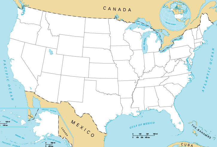
The contiguous United States, also known as the U.S. mainland, officially referred to as the conterminous United States, consists of the 48 adjoining U.S. states and the District of Columbia of the United States in central North America.[1][2] The term excludes the only two non-contiguous states and the last two to be admitted to the Union, which are Alaska and Hawaii, and all other offshore insular areas, such as the U.S. territories of American Samoa, Guam, the Northern Mariana Islands, Puerto Rico, and the U.S. Virgin Islands.[3][4] The colloquial term Lower 48 is also used, especially in relation to Alaska.[5] The term The Mainland is used in Hawaii. The related but distinct term continental United States includes Alaska, which is also in North America, but separated from the 48 states by British Columbia in Canada, but excludes Hawaii and all the insular areas in the Caribbean and the Pacific.[1][6]
The greatest distance on a great-circle route entirely within the contiguous U.S. is 2,802 miles (4,509 km), coast-to-coast between Florida and Washington state;[7] the greatest north–south line is 1,650 miles (2,660 km).[8] The contiguous United States occupies an area of 3,119,884.69 square miles (8,080,464.3 km2). Of this area, 2,959,064.44 square miles (7,663,941.7 km2) is actual land, composing 83.65 percent of the country's total land area, and is comparable in size to the area of Australia.[9] Officially, 160,820.25 square miles (416,522.5 km2) of the contiguous United States is water area, composing 62.66 percent of the nation's total water area.
The contiguous United States, if it were a country, would be fifth on the list of countries and dependencies by area, behind Russia, Canada, China, and Brazil. However, the total area of the United States, including Alaska and Hawaii, ranks third or fourth. Brazil is 166,000 square miles (431,000 km2) larger than the contiguous United States, but smaller than the entire United States including Alaska, Hawaii and overseas territories. The 2020 U.S. census population of the area was 328,571,074, comprising 99.13 percent of the nation's total population, and a density of 111.04 inhabitants/sq mi (42.872/km2), compared to 93.844/sq mi (36.233/km2) for the nation as a whole.[10]
Other terms
[edit]While conterminous U.S. has the precise meaning of contiguous U.S. (both adjectives meaning "sharing a common boundary"), other terms commonly used to describe the 48 contiguous states have a greater degree of ambiguity.
Continental and mainland United States
[edit]Because Alaska is also a part of North America, the term continental United States also includes that state, so the term is qualified with the explicit inclusion of Alaska to resolve any ambiguity.[3][11][12][13] On May 14, 1959, the United States Board on Geographic Names issued the following definitions based partially on the reference in the Alaska Omnibus Bill, which defined the continental United States as "the 49 States on the North American Continent and the District of Columbia..." The Board reaffirmed these definitions on May 13, 1999.[1] However, even before Alaska became a state, it was properly included within the continental U.S. due to being an incorporated territory.[14]
The term mainland United States is sometimes used synonymously with continental United States, but technically refers only to those parts of states connected to the landmass of North America, thereby excluding not only Hawaii and overseas insular areas, but also islands which are part of continental states but separated from the mainland, such as the Aleutian Islands (Alaska), San Juan Islands (Washington), the Channel Islands (California), the Keys (Florida), the barrier islands (Gulf and East Coast states), and Long Island (New York).[15]
CONUS and OCONUS
[edit]CONUS, a technical term used by the U.S. Department of Defense, General Services Administration, NOAA/National Weather Service, and others, has been defined both as the continental United States, and as the 48 contiguous states.[16][17] The District of Columbia is not always specifically mentioned as being part of CONUS.[17]
OCONUS is derived from CONUS with O for outside added, thus referring to Outside of Continental United States.[16][18]
The lower 48
[edit]The term lower 48 is also used to refer to the conterminous United States. The National Geographic style guide recommends the use of contiguous or conterminous United States instead of lower 48 when the 48 states are meant, unless used in the context of Alaska.[5][19] Almost all of Hawaii is south of the southernmost point of the conterminous United States in Florida.
Zone of the Interior
[edit]During World War II, the first four numbered Air Forces of the United States Army Air Forces (USAAF) were said to be assigned to the Zone of the Interior by the American military organizations of the time—the future states of Alaska and Hawaii, then each only organized incorporated territories of the Union, were respectively covered by the Eleventh Air Force and Seventh Air Force during the war.[citation needed]
Terms used in the non-contiguous U.S. jurisdictions
[edit]Residents of Alaska, Hawaii and off-shore U.S. territories have unique labels for the contiguous United States because of their own locations relative to them.
Alaska
[edit]The vast territory of Alaska became the 49th state of the United States on January 3, 1959. Alaska is the northwest extremity of the North American continent, separated from the U.S. West Coast by the Canadian province of British Columbia. The term Lower 48 has, for many years, been a common Alaskan equivalent for "contiguous United States";[20][21] some Alaskans may use the term Outside for those states, though some may use Outside to refer to any location not within Alaska.[22]
Hawaii
[edit]The territory of Hawaii, consisting of the entire Hawaiian Islands archipelago except for Midway Atoll,[a] became the 50th state of the United States on August 21, 1959. It is the southernmost U.S. state, and the latest one to join the Union. Not part of any continent, Hawaii is located in the Pacific Ocean, about 2,200 miles (3,541 km) from North America and almost halfway between North America and Asia. In Hawaii and overseas American territories, for instance, the terms the Mainland or U.S. Mainland are often used to refer to the 49 states in North America.[23][24]
Puerto Rico
[edit]Puerto Rico is an unincorporated territory of the United States located in the northeast Caribbean Sea, approximately 1,000 miles (1,609 km) southeast of Miami, Florida. Puerto Ricans born in Puerto Rico are U.S. citizens and are free to move to the mainland United States. The term Stateside Puerto Rican refers to residents of any U.S. state or the District of Columbia who were born in, or can trace their family ancestry to, Puerto Rico.[25]
U.S. Virgin Islands
[edit]The U.S. Virgin Islands is a U.S. territory located directly to the east of Puerto Rico in the Caribbean Sea.[26] The term stateside is used to refer to the mainland, in relation to the U.S. Virgin Islands[27] (see Stateside Virgin Islands Americans).
American Samoa
[edit]American Samoa is a U.S. territory located in the South Pacific Ocean in Polynesia, south of the equator — it is 2,200 miles (3,500 km) southwest of Hawaii.[28] In American Samoa, the contiguous United States is called the "mainland United States" or "the states"; those not from American Samoa are called palagi (outsiders).[29]
Non-contiguous areas within the contiguous United States
[edit]Apart from off-shore U.S. islands, a few continental portions of the contiguous United States are accessible by road only by traveling through Canada. Point Roberts, Washington; Elm Point, Minnesota, and two nearby points; the Northwest Angle in Minnesota; a peninsula in Osthus Lake in North Dakota's Rolette County and a slice of land on the edge of Lake Metigoshe in Bottineau County bordering Winchester, Canada, are seven such places. Alburgh, Vermont, is not directly connected by land to the rest of the contiguous US, but is accessible by road via bridges from within Vermont and from New York, and nearby Province Point is accessible over land only from Canada, though no roads go there.[30] In contrast, Hyder, Alaska, is physically part of contiguous Alaska and is its easternmost town, but the only practical overland access is by road through Canada.
List of contiguous U.S. states
[edit]The 48 contiguous states are:
- Alabama
- Arizona
- Arkansas
- California
- Colorado
- Connecticut
- Delaware
- Florida
- Georgia
- Idaho
- Illinois
- Indiana
- Iowa
- Kansas
- Kentucky
- Louisiana
- Maine
- Maryland
- Massachusetts
- Michigan
- Minnesota
- Mississippi
- Missouri
- Montana
- Nebraska
- Nevada
- New Hampshire
- New Jersey
- New Mexico
- New York
- North Carolina
- North Dakota
- Ohio
- Oklahoma
- Oregon
- Pennsylvania
- Rhode Island
- South Carolina
- South Dakota
- Tennessee
- Texas
- Utah
- Vermont
- Virginia
- Washington
- West Virginia
- Wisconsin
- Wyoming
In addition, the District of Columbia is within the contiguous United States.
See also
[edit]- Extreme points of the United States
- Mainland
- Metropolitan France, nicknamed "l'Hexagone", an analogous concept in France
Notes
[edit]- ^ Midway is an unorganized and unincorporated territory of the United States.
References
[edit]- ^ a b c "What constitutes the United States, what are the official definitions?". U.S. Geological Survey. Archived from the original on November 16, 2017. Retrieved January 30, 2019.
- ^ "United Airlines website". Archived from the original on April 2, 2012. Retrieved April 4, 2012.
Contiguous United States: The 48 adjoining states and the District of Columbia.
- ^ a b Random House (1991). Random House Webster's College Dictionary. New York: Random House. ISBN 0-679-40110-5.
- ^ These maps show the contiguous 48 states and D.C., but not Alaska and Hawaii.
- "Military Bases in the Contiguous United States". National Park Service, U.S. Department of the Interior. Archived from the original on December 26, 2018. Retrieved November 28, 2012.
- "Soil Moisture Regimes of the Contiguous United States". U.S. Department of Agriculture. Archived from the original on May 13, 2013. Retrieved November 28, 2012.
- ^ a b "National Geographic Style Manual: Alaska". Archived from the original on October 28, 2011. Retrieved December 6, 2013.
The continental United States includes Alaska. [...] In Alaska context, lower forty-eight or lower 48 may be used. Do not hyphenate lower 48 as an adjective. The term outside may be put in quotes on first reference if ambiguous. To distinguish the 48 states from the 49 or 50, use contiguous or conterminous.
- ^ Hyslop, Stephen G. (April 5, 1996). Political Geography of the United States. Guilford Press. p. 90.
- ^ Pickover, Cliff. "The Longest Line in America!". University of Wisconsin. Archived from the original on June 9, 2014. Retrieved October 15, 2013.
- ^ "HowStuffWorks "Geography of the United States - Geography"". Geography.howstuffworks.com. March 30, 2008. Archived from the original on January 19, 2016. Retrieved October 29, 2013.
- ^ "Field Listing: Area". The World Factbook. cia.gov. Archived from the original on July 7, 2020. Retrieved June 13, 2019.
- ^ "Resident Population Data - 2010 Census". United States Census Bureau. Archived from the original on October 28, 2011. Retrieved January 30, 2011.
- ^ "National Geographic Style Manual". Archived from the original on January 2, 2016. Retrieved April 4, 2012.
The continental United States comprises the 48 contiguous, or conterminous, states plus Alaska.
- ^ "United Cargo website". Archived from the original on April 2, 2012. Retrieved April 4, 2012.
Continental United States: The 48 adjoining states, Alaska and District of Columbia.
- ^ "Alaska Airlines website". Archived from the original on February 21, 2011. Retrieved April 4, 2012.
The Continental U.S. includes the lower 48 states as well as the State of Alaska, unless otherwise specified.
- ^ "In the absence of any such statement, Alaska would be regarded as a part of the continental United States." Inland Marine and Transportation Insurance (1949)
- ^ Hyslop, Stephen G. (April 5, 1996). Political Geography of the United States. Guilford Press. pp. 105–110.
- ^ a b "Per Diem Rates (CONUS and OCONUS)". United States General Services Administration. Archived from the original on September 21, 2010. Retrieved September 21, 2010.
- ^ a b "U.S. Navy Style Guide". Archived from the original on March 11, 2015. Retrieved November 24, 2008.
CONUS - "Continental United States." CONUS refers to the 48 contiguous states. It is not synonymous with United States. CONUS is acceptable on first reference.
"CONUS" seems to be used primarily by the American military and the Federal government and those doing business with them. - ^ "Glossary of Army Terms". Archived from the original on June 25, 2012. Retrieved April 4, 2012.
"OCONUS: Outside Continental United States
- ^ "National Geographic Style Manual: conterminous, or contiguous, continental, continental United States". Archived from the original on January 2, 2016. Retrieved September 22, 2011.
Use contiguous, or conterminous, for the 48 states. The continental United States comprises the 48 contiguous, or conterminous, states plus Alaska.
- ^ "Learn to Speak Alaskan - Alaskan Language Tips - Princess Lodges". princesslodges.com. Archived from the original on September 14, 2009. Retrieved March 2, 2009.
- ^ "ALASKA: State Profile". Archived from the original on January 26, 2010. Retrieved December 6, 2013.
- ^ Journal, Copper River Country. "Speaking Alaskan: Words Alaskans Say". Archived from the original on August 20, 2018. Retrieved August 20, 2018.
- ^ Edles, Laura Desfor (2003). "'Race,' 'Ethnicity,' and 'Culture' in Hawai'i: The Myth of the 'Model Minority' State". In Loretta I. Winters and Herman L. DeBose (ed.) New Faces in a Changing America: Multiracial Identity in the 21st Century. SAGE Publications. p. 241. ISBN 9780761923008.
- ^ Hyslop, Stephen G. (April 5, 1996). Political Geography of the United States. Guilford Press. p. 65.
- ^ Five million Puerto Ricans now living in the mainland U.S.[usurped] Caribbean Business. 27 June 2013. Vol 41. Issue 24. Retrieved 13 December 2013.
- ^ "United States Virgin Islands". Encyclopaedia Britannica. Archived from the original on July 31, 2022. Retrieved July 2, 2020.
- ^ "U.S. Virgin Islands - Health and Safety". Frommers.com. Archived from the original on July 3, 2020. Retrieved July 2, 2020.
- ^ "American Samoa". Encyclopaedia Britannica. Archived from the original on August 31, 2022. Retrieved July 2, 2020.
- ^ Mack, Doug. The Not-Quite States Of America. pp. 67, 88, 91.
- ^ Ross, Oakland (June 3, 2011). "Orphans of the atlas". Toronto Star. Archived from the original on June 8, 2011. Retrieved June 5, 2011.
External links
[edit]- Definition of continental
- Definition of contiguous
- Definition of coterminous and conterminous
Contiguous United States
View on GrokipediaDefinition and Scope
Core Definition and Boundaries
The contiguous United States, also referred to as the conterminous United States, consists of the 48 states located on the North American continent that share common land borders, along with the District of Columbia. This definition encompasses an unbroken expanse of territory covering approximately 3,119,884 square miles, excluding Alaska, Hawaii, and all overseas territories and possessions. The term "contiguous" specifically denotes geographical adjacency via land connections, without interruption by significant maritime gaps, distinguishing this core area from the nation's non-adjacent jurisdictions.[3][11] Geographically, the contiguous United States is delimited by international land borders and oceanic coastlines. To the north, it shares the world's longest undefended international boundary with Canada, extending approximately 5,525 miles from the Pacific coast of Washington state through the Great Lakes region to the Atlantic coast of Maine; this border was established through a series of treaties, including the 1818 Convention and the 1846 Oregon Treaty. To the south, the boundary with Mexico spans about 1,954 miles from the Pacific coast of California eastward through Arizona, New Mexico, and Texas to the Gulf of Mexico, primarily defined by the 1848 Treaty of Guadalupe Hidalgo and the 1853 Gadsden Purchase. Eastward, the Atlantic Ocean and Gulf of Mexico form the eastern and southeastern coastlines, while the Pacific Ocean delineates the western edge, with the total coastal length for the contiguous area approximately 61,000 miles when including bays, sounds, and inlets.[12][13][14] Internally, the region features prominent natural divisions such as the Mississippi River watershed, which drains over 1.2 million square miles across 31 states and forms a critical hydrological axis separating eastern and western drainage basins. The District of Columbia is included due to its enclaved position within Maryland, ensuring continuity with the surrounding states without requiring maritime traversal. This configuration reflects the historical completion of continental expansion in 1912, when Arizona and New Mexico achieved statehood, finalizing the land-contiguous framework of the United States.[15]Distinction from Total United States
The contiguous United States is legally distinguished from the total United States in various federal regulations and statutes, where it is defined as the 48 adjoining states and the District of Columbia, excluding Alaska, Hawaii, and U.S. territories.[11] This definition appears in contexts such as federal acquisition rules under the Federal Acquisition Regulation (FAR), which specifies the contiguous United States (often abbreviated as CONUS in official usage) for purposes like procurement, transportation, and logistics planning.[11] Similarly, the Code of Federal Regulations (e.g., 47 CFR § 25.103) uses this scope for satellite communications licensing, limiting "contiguous United States" to the 48 states and D.C. to delineate operational boundaries separate from non-contiguous regions.[10] Administratively, the contiguous United States operates with a unified framework of four primary time zones—Eastern, Central, Mountain, and Pacific—facilitating synchronized national operations like broadcasting and financial markets, whereas the total United States spans six time zones for the states alone, adding Alaska and Hawaii-Aleutian zones that require adjustments for interstate coordination.[16] Interstate commerce laws, governed by the Commerce Clause of the U.S. Constitution (Article I, Section 8), apply uniformly across all states but feature practical exceptions for non-contiguous areas; for instance, shipping between contiguous ports falls under standard regulations, while inter-port transport to Alaska or Hawaii invokes the Merchant Marine Act of 1920 (Jones Act), mandating U.S.-flagged vessels and increasing costs due to geographic separation. These distinctions ensure tailored federal oversight, such as in environmental and trade policies, without fragmenting the contiguous region's integrated economic fabric. In practical terms, transportation networks highlight the separation: the Interstate Highway System, authorized by the Federal-Aid Highway Act of 1956, comprises over 48,000 miles of roadways connecting the 48 contiguous states and D.C. for seamless overland mobility, allowing one to drive from Washington, D.C., to all 48 contiguous states via the interconnected U.S. interstate system on paved roads.[17] However, it relies on air and maritime links for access to Alaska and Hawaii, which have independent highway designations (e.g., Alaska's Interstate A1) without direct continental integration. This infrastructure divide underscores logistical challenges, as non-contiguous areas depend on federal subsidies for ferries and flights to bridge isolation. Geographically, the contiguous United States encompasses approximately 3.12 million square miles in total area (including inland waters), representing about 82% of the total U.S. area of 3.8 million square miles when including Alaska, Hawaii, and territories.[4] This disparity in scale affects resource allocation, with the contiguous portion dominating federal land management and disaster response priorities due to its denser population and economic activity.[3]Terminology and Usage
Alternative Names and Synonyms
The contiguous United States, comprising the 48 states connected by land borders, is referred to by various alternative names that highlight its geographical continuity and distinction from non-contiguous areas. The term "Lower 48" or "Lower 48 states" gained prominence after Alaska's admission to the Union as the 49th state on January 3, 1959, denoting the preceding states in sequential order of statehood while excluding Hawaii. This phrase originated in popular media and everyday discourse, often implying the "lower" numerical status relative to Alaska and Hawaii, and it became widespread in contexts like travel and shipping to differentiate the core landmass.[3] Another synonym is the "Continental United States," a historical term dating back to the 19th century that generally describes the main North American landmass of the country, though official definitions from 1959 onward typically include Alaska but exclude Hawaii.[18] In common usage, it often overlaps with the contiguous United States to emphasize the unbroken continental expanse, contrasting with overseas territories.[3] The "Mainland United States" is a further alternative that underscores the continuous landmass, particularly when contrasting with island jurisdictions like Hawaii or U.S. possessions in the Pacific and Caribbean.[3] This term highlights the territorial integrity of the 48 states as the primary, interconnected portion of the nation's geography, avoiding implications of separation by water. It is frequently employed in logistical, economic, and cultural discussions to specify the core domestic area. In casual and regional speech, especially in Alaska and Hawaii, shorthand variants like "the 48" or simply "the mainland" are used interchangeably with these names, reinforcing the conceptual separation from non-contiguous regions. Military contexts occasionally reference the area as CONUS, which excludes Alaska and Hawaii.[19]Official and Military Designations
The U.S. Department of Defense employs the acronym CONUS, standing for Continental United States, to designate the 48 contiguous states and the District of Columbia, excluding Alaska, Hawaii, and U.S. territories and possessions.[19] This term originated in the mid-20th century, particularly during and after World War II, to address logistical and operational needs in distinguishing domestic continental operations from overseas deployments.[20] CONUS facilitates military planning, supply chain management, and resource allocation by clearly delineating areas within the North American continent between Canada and Mexico, including adjacent territorial waters.[19] As the counterpart to CONUS, the Department of Defense uses OCONUS, meaning Outside the Continental United States, to refer to all locations beyond the 48 contiguous states and the District of Columbia, encompassing Alaska, Hawaii, U.S. territories such as Puerto Rico and Guam, and foreign sites.[21] This designation supports uniform policies for personnel assignments, allowances, and transportation in non-continental areas, ensuring consistent treatment of diverse global postings.[22] Historically, the U.S. Army referred to the contiguous United States as the Zone of the Interior (ZI) during World War I, defining it as the domestic territory supporting overseas combat operations through training, logistics, and administration.[23] This term, detailed in official War Department records, encompassed the continental borders for rear-area functions, excluding theaters of war abroad, and persisted into World War II for similar purposes before evolving into modern usage.[24] In international and official U.S. government contexts, the contiguous United States is sometimes termed the "United States proper" to distinguish it from non-contiguous states and territories, as seen in federal statutes and historical addresses excluding Alaska, Hawaii, Puerto Rico, and other possessions.[25][26] While the United Nations and ISO 3166 standards primarily recognize the full "United States of America" without subdividing for contiguity, U.S. agencies like the U.S. Geological Survey use "conterminous United States" for the 48 states and District of Columbia in geographic and statistical aggregates.[3]Constituent Components
List of Included States
The contiguous United States comprises 48 states located entirely within the North American mainland and the District of Columbia, forming a continuous landmass without interruption by non-contiguous territories.[3] The following table lists these 48 states in alphabetical order, along with their respective dates of admission to the Union:| State | Statehood Date |
|---|---|
| Alabama | December 14, 1819 |
| Arizona | February 14, 1912 |
| Arkansas | June 15, 1836 |
| California | September 9, 1850 |
| Colorado | August 1, 1876 |
| Connecticut | January 9, 1788 |
| Delaware | December 7, 1787 |
| Florida | March 3, 1845 |
| Georgia | January 2, 1788 |
| Idaho | July 3, 1890 |
| Illinois | December 3, 1818 |
| Indiana | December 11, 1816 |
| Iowa | December 28, 1846 |
| Kansas | January 29, 1861 |
| Kentucky | June 1, 1792 |
| Louisiana | April 30, 1812 |
| Maine | March 15, 1820 |
| Maryland | April 28, 1788 |
| Massachusetts | February 6, 1788 |
| Michigan | January 26, 1837 |
| Minnesota | May 11, 1858 |
| Mississippi | December 10, 1817 |
| Missouri | August 10, 1821 |
| Montana | November 8, 1889 |
| Nebraska | March 1, 1867 |
| Nevada | October 31, 1864 |
| New Hampshire | June 21, 1788 |
| New Jersey | December 18, 1787 |
| New Mexico | January 6, 1912 |
| New York | July 26, 1788 |
| North Carolina | November 21, 1789 |
| North Dakota | November 2, 1889 |
| Ohio | March 1, 1803 |
| Oklahoma | November 16, 1907 |
| Oregon | February 14, 1859 |
| Pennsylvania | December 12, 1787 |
| Rhode Island | May 29, 1790 |
| South Carolina | May 23, 1788 |
| South Dakota | November 2, 1889 |
| Tennessee | June 1, 1796 |
| Texas | December 29, 1845 |
| Utah | January 4, 1896 |
| Vermont | March 4, 1791 |
| Virginia | June 25, 1788 |
| Washington | November 11, 1889 |
| West Virginia | June 20, 1863 |
| Wisconsin | May 29, 1848 |
| Wyoming | July 10, 1890 |
