
Community hub
Recent from talks
Contribute something
Nothing was collected or created yet.
Deptford
View on Wikipedia
Deptford (/ˈdɛtfərd/ DET-furd)[1] is an area on the south bank of the River Thames in southeast London, in the Royal Borough of Greenwich and London Borough of Lewisham. It is named after a ford of the River Ravensbourne. From the mid 16th century to the late 19th it was home to Deptford Dockyard, the first of the Royal Dockyards. This was a major shipbuilding dock and attracted Peter the Great to come and study shipbuilding. Deptford and the docks are associated with the knighting of Sir Francis Drake by Queen Elizabeth I aboard the Golden Hind,[2] the legend of Sir Walter Raleigh laying down his cape for Elizabeth,[3] Captain James Cook's third voyage aboard HMS Resolution,[4] and the mysterious apparent murder of Christopher Marlowe in a house along Deptford Strand.[5]
Key Information


Though Deptford began as two small communities, one at the ford, and the other a fishing village on the Thames, Deptford's history and population has been mainly associated with the docks established by Henry VIII. The two communities grew together and flourished during the period when the docks were the main administrative centre of the Royal Navy, and some grand houses like Sayes Court, home to diarist John Evelyn, and Stone House on Lewisham Way, were erected. The area declined as first the Royal Navy moved out, and then the commercial docks themselves declined until the last dock, Convoys Wharf, closed in 2000.
A Metropolitan Borough of Deptford existed from 1900 until 1965, when the area became part of the newly created London Borough of Lewisham.[6]
History
[edit]Ancient
[edit]Deptford took its name from a ford across the Ravensbourne (near what is now Deptford Bridge DLR station) along the route of the Celtic trackway which was later paved by the Romans and developed into the medieval Watling Street.[7] The modern name is a corruption of "deep ford".[8]
Deptford was part of the pilgrimage route from London to Canterbury used by the pilgrims in Chaucer's Canterbury Tales, and is mentioned in the prologue to "The Reeve's Tale".[9] The ford developed into first a wooden then a stone bridge, and in 1497 saw the Battle of Deptford Bridge, in which rebels from Cornwall, led by Michael An Gof, marched on London protesting against punitive taxes, but were soundly beaten by the King's forces.[10]
Early modern
[edit]
A second settlement, Deptford Strand or Deptford Strond, developed as a modest fishing village on the Thames until Henry VIII used that site for a royal dock repairing, building and supplying ships, after which it grew in size and importance, shipbuilding remaining in operation until March 1869.[11]
Trinity House, the organisation concerned with the safety of navigation around the British Isles, was formed in Deptford in 1514, with its first Master being Thomas Spert, captain of the Mary Rose. It moved to Stepney in 1618. The name "Trinity House" derives from the church of Holy Trinity and St Clement, which adjoined the dockyard.[12]
Originally separated by market gardens and fields, the two areas merged over the years,[13] with the docks becoming an important part of the Elizabethan exploration.[14] Queen Elizabeth I visited the royal dockyard on 4 April 1581 to knight the adventurer Francis Drake.[15] As well as for exploration, Deptford was important for trade – the Honourable East India Company had a yard in Deptford from 1607 until late in the 17th century,[16] later (1825) taken over by the General Steam Navigation Company. It was also connected with the slave trade, John Hawkins using it as a base for his operations,[17] and Olaudah Equiano, the slave who became an important part of the abolition of the slave trade, was sold from one ship's captain to another in Deptford around 1760.[18][19]
Diarist John Evelyn lived in Deptford at Sayes Court, the manor house of Deptford, from 1652 after he had married the daughter of the owner of the house, Sir Richard Browne.[20] After the Restoration, Evelyn obtained a 99-year lease of the house and grounds,[21] and laid out meticulously planned gardens in the French style, of hedges and parterres. In its grounds was a cottage at one time rented by master woodcarver Grinling Gibbons. After Evelyn had moved to Surrey in 1694, Peter the Great, the Russian tsar, studied shipbuilding for three months in 1698 while staying at Sayes Court.[15] Evelyn was angered at the antics of the tsar, who got drunk with his friends who, using a wheelbarrow with Peter in it, rammed their way through a "fine holly hedge". Sayes Court was demolished in 1728-9 and a workhouse built on its site.[21] Part of the estates around Sayes Court were purchased in 1742 for the building of the Navy Victualling Yard, which was renamed the Royal Victoria Victualling Yard in 1858 after a visit by Queen Victoria.[22] This massive facility included warehouses, a bakery, a cattleyard/abattoir and sugar stores, and closed in 1961. All that remains is the name of Sayes Court Park, accessed from Sayes Court Street off Evelyn Street, not far from Deptford High Street. The Pepys Estate, opened on 13 July 1966, is on the former grounds of the Victualling Yard.[23]

The Docks had been gradually declining from the 18th century; the larger ships being built found the Thames difficult to navigate, and Deptford was under competition from the new docks at Plymouth, Portsmouth and Chatham.[24]
19th century
[edit]When the Napoleonic Wars ended in 1815 the need for a Docks to build and repair warships declined; the Docks shifted from shipbuilding to concentrate on victualling at the Royal Victoria Victualling Yard, and the Royal Dock closed in 1869.[25] From 1871 until 1913 the shipyard site was the City of London Corporation's Foreign Cattle Market, to which live animals were brought by cattle boat from four continents and from whence came about half of London's meat supply.
20th century
[edit]The yard was taken over by the War Office in 1914,[26][27] and was an Army Supply Reserve Depot in the First and Second World Wars.[28][29] The site lay unused until being purchased by Convoys (newsprint importers) in 1984, and eventually came into the ownership of News International.[30][31] In the mid-1990s, although significant investment was made on the site, it became uneconomic to continue using it as a freight wharf.[32] In 2008 Hutchison Whampoa bought the 16ha site from News International with plans for a £700m 3,500-home development scheme.[33] The Grade II listed Olympia Warehouse will be refurbished as part of the redevelopment of the site.[31]
Deptford experienced economic decline in the 20th century with the closing of the docks, and the damage caused by the bombing during the Blitz in the Second World War – in November 1944 a V-2 rocket destroyed a Woolworths store in New Cross Gate, killing 160 people[34][35] - contributing to the 703 civilian deaths caused by enemy action within Deptford Metropolitan Borough throughout the war.[36] High unemployment caused some of the population to move away as the riverside industries closed down in the late 1960s and early 1970s.[37]
21st century
[edit]The local council have developed plans with private companies to regenerate the riverside area,[38] and the town centre.[39]
Governance
[edit]
The Manor of Deptford or West Greenwich was bestowed by William the Conqueror upon Gilbert de Magminot or Maminot, bishop of Lisieux,[40] one of the eight barons associated with John de Fiennes for the defence of Dover Castle. Maminot held the head of his barony at Deptford[41][42] and according to John Lyon writing in 1814, he built himself a castle, or castellated mansion at Deptford. The location of the building is not known, but ancient foundations found on the brow of Broomfield, near the Mast Dock and adjacent to Sayes Court may be the remains of the building.[41][42][43]

Deptford was mostly located in the Blackheath Hundred of the county of Kent, with the Hatcham part in the Brixton Hundred of Surrey.[44]
In 1730 Deptford was divided into the two parishes of St Nicholas and St Paul.[21] It was also referred to as West Greenwich, with the modern town of Greenwich being referred to as East Greenwich until this use declined in the 19th century.[45] The whole of Deptford came within the Metropolitan Police District in 1830 and was included in the area of responsibility of the Metropolitan Board of Works in 1855.
It was transferred to the County of London in 1889. Originally under the governance of the ancient parishes of St Paul and St Nicholas, in 1900, a Metropolitan Borough of Deptford was formed out of the southern parish of St Paul,[46] with St Nicholas and the area around the Royal Dockyard coming under the governance of the Metropolitan Borough of Greenwich.[6][47]
Under the London Government Act 1963, the Metropolitan Borough of Deptford was absorbed in 1965 into the newly created London Borough of Lewisham,[48] with the Deptford St Nicholas area becoming part of the Royal Borough of Greenwich, with both these new boroughs now forming part of the new Greater London body. In 1994 the bulk of the northern part, including the former Royal Dockyard area, was transferred to Lewisham, an adjustment of about 40 hectares (99 acres),[49] leaving only the north eastern area, around St Nicholas's church, in Greenwich.
Deptford is split between two electoral wards - Evelyn in the north and part of New Cross to the south.[50] Following public consultation, the Local Government Boundary Commission for England recommended in June 2020 that the Deptford wards (Evelyn and New Cross) should be unified and renamed Deptford.[51]
Geography
[edit]
Deptford borders the areas of Brockley and Lewisham to the south, New Cross to the west and Rotherhithe to the north west; the Ravensbourne river divides it from Greenwich to the east, and the Thames separates the area from the Isle of Dogs to the north east; it is contained within the London SE8 post code area.[52] The area referred to as North Deptford is the only part of the London Borough of Lewisham to front the Thames and is sandwiched between Rotherhithe and Greenwich. Much of this riverside estate is populated by the former Naval Dockyards, now known as Convoys Wharf, the Pepys Estate and some southern fringes of the old Surrey Commercial Docks.
The name Deptford – anciently written Depeford meaning "deep ford"[21] — is derived from the place where the road from London to Dover, the ancient Watling Street (now the A2), crosses the River Ravensbourne at the site of what became Deptford Bridge at Deptford Broadway. The Ravensbourne crosses under the A2 at roughly the same spot as the Docklands Light Railway (DLR) crosses over; and at the point where it becomes tidal, just after Lewisham College, it is known as Deptford Creek, and flows into the River Thames at Greenwich Reach.[53]
Demography
[edit]
Deptford's population has been mainly associated with the docks since the establishment of the Royal Docks by Henry VIII, though there has also been some market gardening and potteries.[54] When the docks were thriving as the main administrative centre of the British Navy, so the area prospered, and fine houses were built for the administrative staff and the skilled shipbuilders, and a few grand houses like Sayes Court and Stone House on Lewisham Way were erected.[55]
There was a start of a demographic shift downwards when the Royal Navy pulled out of Deptford, and the docks moved into storage and freight.[56] The downward shift continued into the 20th century as the local population's dependency on the docks continued: as the docks themselves declined, so did the economic fortune of the inhabitants until the last dock, Convoys Wharf, closed in 2000.[57]
In common with neighbouring areas of South East London, immigrants from the Caribbean settled in Deptford in the 1950s and 1960s.[58]
Deptford's northern section nearest the old docks contains areas of council housing, with some concentrations of people experiencing the forms of deprivation typically associated with the poverty of Inner London. Northern Deptford near the Thames, along with neighbouring New Cross, has been touted as "the new Shoreditch" by some journalists and estate agents paying attention to a trendy arts and music scene that is popular with students and artists.[59] To the south where Deptford rolls into the suburban spread of Brockley, the previously multi-occupancy Victorian houses are being gentrified by young city workers and urban professionals.[60] Deptford has a growing Vietnamese community reflected in the number of restaurants in the area.
Deptford contains a number of student populations, including those of Goldsmiths College, the University of Greenwich, Bellerbys College and Laban Dance Centre. Goldsmiths College's hall of residence, Rachel McMillan, in Creek Road was sold in 2001 for £79 million,[61] and was subsequently demolished and replaced with the McMillan Student Village which opened in 2003 and provides accommodation for approximately 970 students of the University of Greenwich, Trinity Laban and Bellerbys colleges.[62]
Economy
[edit]
Deptford's economic history has been strongly connected to the Dockyard - when the Dockyard was thriving, so Deptford thrived; with the docks now all closed, Deptford has declined economically.[25][37] However, areas of Deptford are being gradually re-developed and gentrified - and the local council has plans to regenerate the riverside and the town centre.[39] A large former industrial site by the Thames called Convoys Wharf is scheduled for redeveloping into mixed use buildings. This will involve the construction of around 3,500 new homes and an extension of the town centre northwards towards the river.[38]
The site of a former foundry (established in 1881 by J. Stone & Co in Arklow Road) which closed in 1969 is being redeveloped for commercial and residential use.[63]
Much of the area along Creek Road, close to Greenwich, has also been redeveloped, with the demolition of the old Deptford Power Station and Rose Bruford College buildings. Aragon Tower on the Pepys Estate was sold by Lewisham Borough to fund regeneration plans for the estate; the award-winning refurbishment into privately owned accommodation was featured in the BBC One documentary, "The Tower".[64][65]
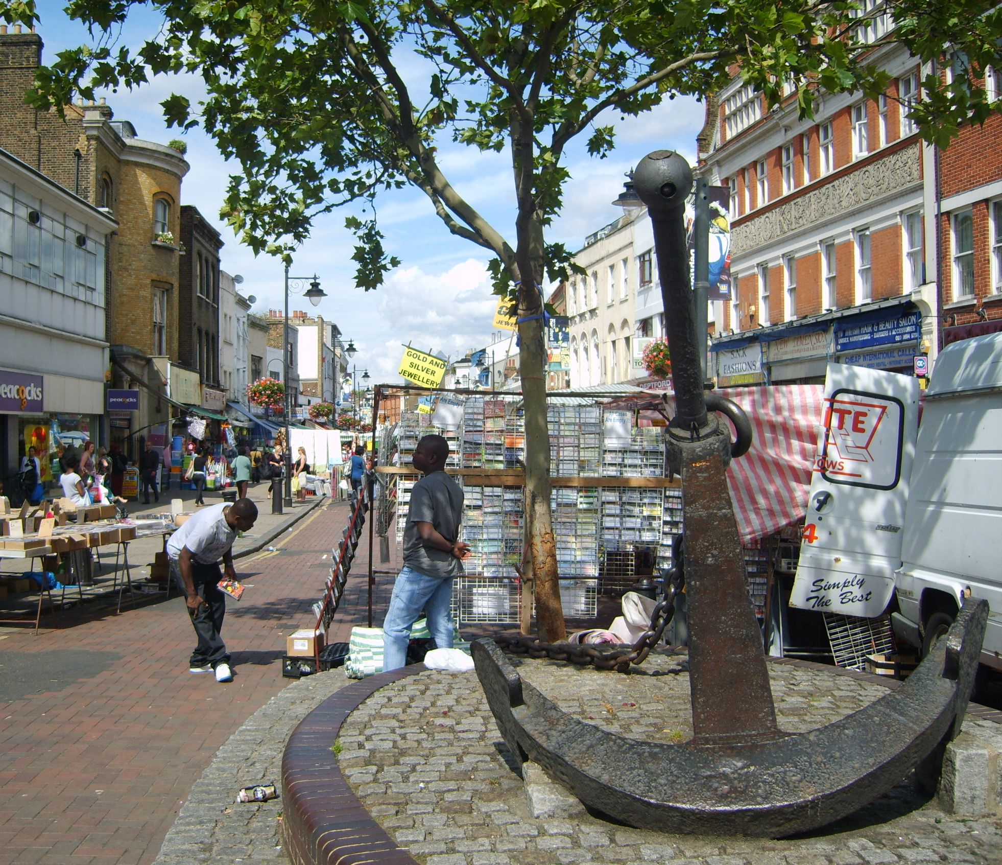
Deptford Market, a street market in Deptford High Street sells a range of goods, and is considered one of London's liveliest street markets.[66] In February 2005, the High Street was described as "the capital's most diverse and vibrant high street" by Yellow Pages business directory, using a unique mathematical formula.[67]
Culture
[edit]
The Albany Theatre, a community arts centre with a tradition of "radical community arts and music" including holding 15 "Rock Against Racism" concerts,[68] has its roots in a charity established in 1894 to improve the social life of Deptford's deprived community.[69] The original building, the Albany Institute, was opened in 1899 on Creek Road, changing its name in the 1960s to the Albany Empire. It was burnt down in 1978, but rebuilt on Douglas Way, with Prince Charles laying the foundation stone, and Diana, Princess of Wales opening it in 1982.[69]
Deptford Cinema is a volunteer run, not-for-profit, community cinema, art gallery, and occasional music venue, open since late 2014 and located at 39 Deptford Broadway. At the time of opening it was the borough of Lewisham's only functioning cinema.[70]
Creekside, a regeneration area beside Deptford Creek,[71] is used for educational and artistic purposes,[72][73] such as the Laban Dance Centre, which was designed by Swiss architects Jacques Herzog and Pierre de Meuron, and opened in February 2003; and the Art in Perpetuity Trust (APT) gallery and studio space.[74] In 2002 the Creekside Discovery Centre was established to retain some urban habitat that was being destroyed through the area's regeneration.[75] A record label, Deptford Fun City Records was set up by Miles Copeland III, brother of Stewart Copeland, in the late 1970s as an outlet for Deptford bands such as Alternative TV[76] and Squeeze.[77][78]
The area has several pubs, including the Dog & Bell which has a reputation for serving a range of cask ales,[79][80] The Royal Albert which is a Grade II listed building from the mid-19th century[81] that was previously known as The Paradise Bar and saw early gigs by Bloc Party and Art Brut,[82][83] and The Bird's Nest which has live music, film and art performances from local bands and artists.[84][85] The town hall of the former Metropolitan Borough of Deptford, built in 1905 with decorative sculpture by Henry Poole,[86] lies just outside Deptford, on the New Cross Road in New Cross. It was purchased by Goldsmiths College in 2000.[87]
There are several green spaces in the area, the largest being Brookmill Park, Deptford Park, Ferranti Park, Pepys Park and Sayes Court Park.[88] In 1884 William John Evelyn, a descendant of John Evelyn, sold ground then being used as market gardens in Deptford, to the London County Council for less than its market value, as well as paying toward the cost of its purchase. It was officially opened to the public as Deptford Park on 7 June 1897.[89][90] In 1886, he dedicated an acre and a half of the Sayes Court recreation ground in perpetuity to the public and a permanent provision was made for the Evelyn estate to cover the expense of maintenance and caretaking, this was opened on 20 July 1886.[91][92]
Transport
[edit]
Deptford is served by National Rail and Docklands Light Railway services. The National Rail service is operated by Southeastern and Thameslink on the suburban Greenwich Line at Deptford railway station,[93] the oldest passenger-only railway station in London.[94][95] Deptford station was redeveloped during 2011 and 2012. The works included the demolition of the original 1836 station building and its replacement by a new station to the west in the former station yard.[96][97] Deptford's DLR station is at Deptford Bridge on the DLR's Lewisham branch.[98][99]
There are two main road routes through Deptford: the A200 which runs along Evelyn Street and Creek Road,[citation needed] and the A2 which runs along New Cross Road, and is the modern version of the Celtic trackway which was later paved by the Romans and developed into the medieval Watling Street.[7] The A20 marks the southern boundary of the area, along Lewisham Way and Loampit Vale.[citation needed]
Since June 2016, Deptford has been on the cycling route of the London Cycleway route C10 that starts in Greenwich and ends in Euston in central London.[100] A second Cycleway route, C14, between Waterloo and Thamesmead, passes through Deptford's riverfront.[101] A third Cycleway route, C4, was opened in September 2022 and runs along Evelyn Street (A200) and provides protected cycle links to Tower Bridge and Woolwich.
Since 2024, Lewisham Council has been trialling a timed pedestrianisation of part of Deptford High Street on market days. In April 2025, the council announced[102] plans to make the section between New Cross Road and Hamilton Street pedestrian-only seven days a week. The scheme includes new planting, public realm improvements and support for outdoor trading, with exemptions for residents, businesses, Blue Badge holders and essential service vehicles. The proposals are intended to improve air quality, safety and accessibility while encouraging footfall and local spending.
Education
[edit]There are five primary schools in the area.[103] There are no local secondary schools directly in Deptford, however there are two secondary schools near the border between New Cross and Deptford: Deptford Green, regarded by Ofsted as "needing improvement",[104] and Addey and Stanhope, regarded by Ofsted as "good".[105] A branch of the further education college, Lewisham College incorporating Southwark College (known as LeSoCo), is located on Deptford Church Street; the college was regarded as "inadequate" in the 2014 Ofsted inspection.[106]
Landmarks
[edit]
Deptford railway station is one of the oldest suburban stations in the world,[107] being built (c.1836-38) as part of the first suburban service (the London and Greenwich Railway), between London Bridge and Greenwich. Close to Deptford Creek is a Deptford pumping station, a Victorian pumping station built in 1864, part of the massive London sewerage system designed by civil engineer Sir Joseph Bazalgette.[108]
The former Deptford Power Station, in use from 1891 to 1983, originated as a pioneering plant designed by Sebastian de Ferranti, which when built was the largest station in the world.[109]
In 2008, Lewisham Council granted permission for the last remnants of the Deptford Ragged School known as The Princess Louise Institute to be demolished and replaced by flats.[110]
Albury Street (previously Union Street) contains a fine row of early urban houses largely dating from 1705 to 1717 which were once popular with naval captains and shipwrights.[111]
Tanners Hill in the St John's or New Deptford area to the south of New Cross Road,[112] is part of an Area of Archaeological Priority due to the longevity of settlement and early industry,[113] and contains a set of commercial buildings from numbers 21 to 31 which are survivors from a row of 31 which were built in the 1750s on the site of cottages dating from the 17th century.[114]
These timber-frame buildings have a Grade II listing from English Heritage[115] and are home to established businesses such as bicycle maker Witcomb Cycles.[116] Of Deptford's two important houses, Sayes Court no longer exists, but the Stone House in St Johns, built around 1772 by the architect George Gibson the Younger, and described by Pevsner as "the one individual house of interest in this area", still stands by Lewisham Way.[117]
Deptford's Albany Theatre has a history stretching back over 100 years and is a prominent feature of the South-East London arts scene.
Churches
[edit]
St Nicholas's Church, the original parish church, dates back to the 14th century but the current building is 17th century. The entrance to the churchyard features a set of skull-and-bones on top of the posts. A plaque on the north wall commemorates playwright Christopher Marlowe, who was stabbed to death by Ingram Frizer in a nearby house, and buried in an unmarked grave in the churchyard on 1 June 1593. Frizer was pardoned for the killing on the grounds that he acted in self-defence.[118][119]
There is also St. Luke's, another historic circular church, dating from 1870. It is the daughter church of the parish of St Nicholas'.
In the 18th century St. Paul's, Deptford (1712–1730) was built,[120] acclaimed by the Royal Commission on the Historical Monuments of England as one of the finest Baroque churches in the country.[121] John Betjeman is attributed as referring to the church as "a pearl at the heart of Deptford".[122] It was designed by the architect Thomas Archer, who was a pupil of Sir Christopher Wren, as part of the Commission for Building Fifty New Churches with the intention of instilling pride in Britain, and encouraging people to stay in London rather than emigrate to the New World.[123]
Adjacent to the church yard is Albury Street, which contains some fine 18th-century houses which were popular with sea captains and shipbuilders.[124]
Deptford Dockyard
[edit]
Deptford Dockyard was established in 1513 by Henry VIII as the first Royal Dockyard, building vessels for the Royal Navy,[125] and was at one time known as the King's Yard.[126] It was shut down from 1830 to 1844 before being closed as a dockyard in 1869,[127] and is currently known as Convoys Wharf. From 1871 until the First World War it was the City of London Corporation's Foreign Cattle Market. In 1912, The Times reported that over 4 million head of live cattle, and sheep, had been landed.[citation needed]
From 1932 until 2008 the site was owned by News International, which used it to import newsprint and other paper products from Finland until early 2000. It is now owned by Hutchison Whampoa Limited and is subject to a planning application to convert it into residential units,[128] though it has safeguarded wharf status.[129]
Other notable shipyards in Deptford were Charles Lungley's Dockyard and the General Steam Navigation Company's yards at Deptford Green and Dudman's Dock, also sometimes referred to as Deadmans Dock at Deptford Wharf.
Murder of Christopher Marlowe
[edit].jpg)
The Elizabethan playwright Christopher Marlowe was killed during an alleged drunken brawl in Eleanor Bull's house in Deptford Strand in May 1593. Various versions of Marlowe's death were current at the time. Francis Meres says Marlowe was "stabbed to death by a bawdy serving-man, a rival of his in his lewd love" as punishment for his "epicurism and atheism".[130] In 1917, in the Dictionary of National Biography, Sir Sidney Lee wrote that Marlowe was killed in a drunken fight. Some modern theories posit that he was assassinated.[131] It is commonly assumed that the fight took place in a Deptford tavern.[132]
The scholar Leslie Hotson discovered in 1925 the coroner's report on Marlowe's death in the Public Record Office which gave fuller details.[133] Marlowe had spent all day in a house owned by the widow Eleanor Bull, along with three men, Ingram Frizer, Nicholas Skeres and Robert Poley.[134] Witnesses testified that Frizer and Marlowe had earlier argued over the bill, exchanging "divers malicious words." Later, while Frizer was sitting at a table between the other two and Marlowe was lying behind him on a couch, Marlowe snatched Frizer's dagger and began attacking him. In the ensuing struggle, according to the coroner's report, Marlowe was accidentally stabbed above the right eye, killing him instantly.[133] The jury concluded that Frizer acted in self-defence, and within a month he was pardoned. Marlowe was buried in an unmarked grave in the churchyard of St Nicholas, Deptford, on 1 June 1593.[135]
Notable people
[edit]Among people associated with Deptford are Christopher Marlowe, who was stabbed to death at Deptford Strand;[136] diarist John Evelyn (1620–1706), who lived at Sayes Court,[137] and had Peter the Great (1672–1725) as a guest for about three months in 1698;[138] Sir Francis Drake, who was knighted by Queen Elizabeth I aboard the Golden Hind in Deptford Docks;[139] and Emperor Norton (Joshua Abraham Norton), the San Francisco eccentric and self-proclaimed "Emperor of the United States", who was born in Deptford in 1818.[140]
Other people who have lived in Deptford range from the first governor of the East India Company and ambassador to the court of Russia, Thomas Smythe, whose magnificent house was destroyed by fire in 1618;[21] to early members of the Chartist movement, John Gast[141] and George Julian Harney;[142] and the Cleveleys, John Cleveley the Elder and his sons John and Robert, a family of marine artists who also worked as tradesmen in the Dockyard.[143] Another artist born in Deptford is Henry Courtney Selous,[144] who is known for The Opening of The Great Exhibition, painted in 1851.[145]
Members of rock groups Squeeze and Dire Straits lived on the Crossfield Estate in Deptford in the late 1970s,[146][147] along with Mark Perry, founder of the punk fanzine Sniffin Glue and punk rock band Alternative TV.[148] The DJ and music journalist Danny Baker lived near the Crossfield Estate, where he was born and brought up.[149] Steve Harley, frontman of the glamrock band Cockney Rebel, was born in Deptford.[150]
Children's author Robin Jarvis wrote two trilogies of books: The Deptford Mice (and a couple of spin off books called The Deptford Mouselets series) and The Deptford Histories, set in and around Deptford and featuring many of its landmarks.[151][152]
Deptford-born Rapman (Andrew Onwubolu) is a British rapper and filmmaker who gained fame through YouTube storytelling series like "Blue Story Trilogy" and "Shiro's Story." His unique style blends rap with visual narratives, addressing London's urban life and social issues. RapMan's success led to a record deal with Island Records and Roc Nation. In 2019, he directed the critically acclaimed film "Blue Story," which became the highest-grossing British urban film.[153] His work continues to influence UK grime and hip-hop culture, spanning music, film, and television.
References
[edit]- ^ G.M. Miller, BBC Pronouncing Dictionary of British Names, London: Oxford University Press (1971), p. 44.
- ^ Sir Francis Drake: The Queen's Pirate, pp 218-19, H Kelsey, Yale University Press (1 September 2000), ISBN 0-300-08463-3
- ^ Sir Walter Ralegh and the Quest for El Dorado, pages 83 & 176, Marc Aronson, Clarion Books (17 April 2000), ISBN 0-395-84827-X
- ^ Captain James Cook, pp 273-294, Richard Hough, W.W. Norton (17 August 1996), ISBN 0-393-31519-3
- ^ Greenwich 2000 (5 January 2010). "Greenwich England: Deptford". Wwp.greenwich2000.com. Archived from the original on 19 February 2014. Retrieved 5 July 2010.
{{cite web}}: CS1 maint: numeric names: authors list (link) - ^ a b [1] Archived 8 June 2011 at the Wayback Machine Lewisham Borough Historical resource
- ^ a b "Roman and Saxon Roads and Transport". Dartford archive. Kent County Council. Archived from the original on 9 January 2002 – via Dartford Grammar School.
- ^ Patrick Hanks; Flavia Hodges; Mills, A. D.; Room, Adrian (2002). The Oxford Names Companion. Oxford: The University Press. p. 1003. ISBN 978-0-19860561-4.
- ^ Geoffrey Chaucer. "The Reeve's Prologue". Harvard University. line 3906. Archived from the original on 20 June 2019. Retrieved 20 June 2019.
- ^ Daniel Lysons; Samuel Lysons (1811). The Environs of London: pt. 2. p. 468.
- ^ Deptford, Old and New London: Volume 6 (1878), pp. 143–64. accessed 19 September 2009
- ^ Geoffrey Moorhouse (2005). Great Harry's Navy. London: Weidenfeld & Nicolson. pp. 169, 170. ISBN 978-0-297-64544-3.
- ^ "Deptford". Ideal homes. Archived from the original on 1 June 2008. Retrieved 17 August 2008.
- ^ "The Tudor and Stuart port". About maritime London. Port Cities. Archived from the original on 22 December 2008. Retrieved 9 January 2010.
- ^ a b Greenwich 2000 - Deptford Strand Archived 11 July 2011 at the Wayback Machine
- ^ "The East India Company's Yard at Deptford". Port cities. Archived from the original on 9 June 2011. Retrieved 5 July 2010.
- ^ "Slavetrade in the caribbean, from the beginning till abolishment". Paradise inn Carriacou. Archived from the original on 12 April 2010. Retrieved 9 January 2010.
- ^ "Olaudah Equiano, UK". It's Caribbean. Archived from the original on 13 October 2008. Retrieved 9 January 2010.
- ^ The Interesting Narrative of the Life of Olaudah Equiano Or Gustavus Vassa, The African, Written By Himself, Volume 1, Olaudah Equiano, Kessinger Publishing, 2004, ISBN 1419167499
- ^ Douglas D. C. Chambers, 'Evelyn, John (1620–1706)', Oxford Dictionary of National Biography, Oxford University Press, September 2004; online edn, January 2008, accessed 13 January 2008.
- ^ a b c d e Daniel Lysons (1796). Deptford, St Nicholas, The Environs of London: volume 4: Counties of Herts, Essex & Kent. T Cadell and W Davies. pp. 359–85.
{{cite book}}:|work=ignored (help) - ^ "Deptford & Millwall - add info". London-footprints.co.uk. Archived from the original on 20 August 2009. Retrieved 5 July 2010.
- ^ "Pepys Estate Tenants Action Group". Archived from the original on 26 June 2009. Retrieved 11 June 2010.
- ^ "Deptford and Woolwich: London's Royal Dockyards - London's docks and shipping - Port Cities". portcities.org.uk. Archived from the original on 10 January 2010. Retrieved 14 January 2010.
- ^ a b "Deptford and Woolwich: London's Royal Dockyards - London's docks and shipping - Port Cities". portcities.org.uk. Archived from the original on 31 December 2009. Retrieved 14 January 2010.
- ^ Sale of Deptford Market. Government to Pay £387,000. The Times, 13 March 1926, p.12, col F
- ^ Future of Deptford Market. War Office decision to buy. The Times, 6 February 1924, p12, col B
- ^ Greenwich Industrial History Proposal to list the remains of the Royal Dockyard at Deptford 6 January 2010
- ^ PRO Archived 5 January 2010 at the Wayback Machine Works 43/614-6
- ^ london-footprints.co.uk Archived 20 July 2008 at the Wayback Machine Deptford Dockyard
- ^ a b Convoys Wharf London Archived 3 October 2009 at the Wayback Machine, Richard Rogers Partnership, 2002
- ^ Safeguarded Wharves on the River Thames - London Plan Implementation Report Archived 4 June 2011 at the Wayback Machine, Mayor of London, January 2005, pp 60-63
- ^ "Mothballed £700m Deptford housing scheme on track". Building. 6 November 2009. Retrieved 5 July 2010.
- ^ Steve Crawshaw (2004). Easier Fatherland: Germany and the Twenty-First Century. A&C Black. p. 170. ISBN 978-0-8264-6320-3.
- ^ "Flying Bombs & Rockets". Archived from the original on 14 December 2012. Retrieved 15 January 2010.
- ^ "Civilian War Deaths, Metropolitan Borough of Deptford". cwgc.org. Retrieved 15 September 2025.
- ^ a b "About". Deptford Town Centre. Towntalk. Archived from the original on 1 January 2013. Retrieved 14 January 2010.
- ^ a b "Concept". richardrogers.co.uk. Archived from the original on 3 October 2009. Retrieved 19 December 2009.
- ^ a b "Proposals for the regeneration of Deptford town centre". Lewisham Council. Archived from the original on 8 June 2011. Retrieved 14 January 2010.
- ^ A History of Deptford Dews, N, (London, 1884)
- ^ a b Lyon, John (1814). The history of the town and port of Dover and of Dover castle by John Lyon, published 1814, p. 139. Retrieved 5 July 2010.
- ^ a b Dedication to the Public of Deptford Park by Dr W.J. Collins, 1897
- ^ Ireland, William Henry (1830). England's topographer, or A new and complete history of the county of Kent by William Henry Ireland, 1830, page 731. Retrieved 5 July 2010.
- ^ 'Parishes: Hatcham (Parish of Deptford St Paul)', A History of the County of Surrey: Volume 4 (1912) pp. 42-44. accessed 19 September 2009
- ^ "The History and Topographical Survey of the County of Kent: Volume 1 (1797), pp. 340-71". British-history.ac.uk. 22 June 2003. Retrieved 5 July 2010.
- ^ Great Britain Historical GIS / University of Portsmouth, Deptford MB (historic map). Retrieved {{{accessdate}}}. "Deptford MetB through time | Administrative history of Local Government District: Hierarchies, boundaries". Archived from the original on 12 April 2012. Retrieved 4 August 2008.
{{cite web}}: CS1 maint: bot: original URL status unknown (link) - ^ Great Britain Historical GIS / University of Portsmouth, Deptford St Nicholas (historic map). Retrieved {{{accessdate}}}. "Deptford St Nicholas CP/AP through time | Administrative history of Parish-level Unit: Hierarchies, boundaries". Archived from the original on 12 April 2012. Retrieved 4 August 2008.
{{cite web}}: CS1 maint: bot: original URL status unknown (link) - ^ [2] Museum of London
- ^ OPSI - Greenwich and Lewisham (London Borough Boundaries) Order 1993
- ^ "About the Area". neighbourhood.statistics.gov.uk. Archived from the original on 4 June 2011. Retrieved 29 December 2009.
- ^ "New electoral arrangements for Lewisham Council Final Recommendations" (PDF). Local Government Boundary Commission for England. June 2020. pp. 10–11. Archived (PDF) from the original on 4 March 2021.
- ^ "Location of Deptford telephone exchange". streetmap.co.uk. Archived from the original on 23 October 2012. Retrieved 29 December 2009.
- ^ "Deptford Creek - About maritime London - Port Cities". portcities.org.uk. Archived from the original on 3 March 2009. Retrieved 19 December 2009.
- ^ Demographic, social and economic indices for wards in Greater London, Eric J. Thompson, Greater London Council (1972), ASIN B0006D80AS
- ^ "St John's, Deptford New Town Case Study". ideal-homes.org.uk. Archived from the original on 10 April 2008. Retrieved 17 August 2008.
- ^ Demographic review of Greater London 1983, Greater London Council (1983), ISBN 0-7168-1348-3
- ^ INFORMATION SHEET Deptford and the dockyards Archived 10 July 2011 at the Wayback Machine The Emancipation of the Dispossessed
- ^ UCL Case Study - Deptford https://www.ucl.ac.uk/urbanbuzz/downloads/projects_09/Deptford_Case_Study.pdf
- ^ "PrimeLocation.co.uk". PrimeLocation.co.uk. Retrieved 5 July 2010. Shoreditch is a former working class area of East London that has a number of contemporary art galleries and is home to a number of creative and media companies
- ^ "Lewisham Deptford". ukpollingreport.co.uk. Archived from the original on 21 April 2009. Retrieved 5 July 2010.
- ^ Rachel McMillan, Greenwich, Opal savills.com
- ^ "McMillan Student Village". Accommodation - University of Greenwich. gre.ac.uk. Archived from the original on 22 August 2009. Retrieved 29 December 2009.
- ^ "Deptford Foundry, Arklow Road". Turley. Archived from the original on 3 April 2018. Retrieved 3 April 2018.
- ^ "Television: Kathryn Flett on Paris". The Guardian. London. 1 July 2007. Retrieved 19 December 2009.
- ^ "2006 - Berkeley Homes". berkeleyhomes.co.uk. Retrieved 19 December 2009.
- ^ "London's Best Markets - Time Out London". timeout.com. Archived from the original on 15 September 2008. Retrieved 16 August 2008.
- ^ Yell Group, Deptford is Top of the Shops - New study reveals London's hidden gems in the High Street Hit Parade, 23 February 2005.
- ^ Gilchrist, Ruth; Jeffs, Tony (March 2001). Settlements, social change and ... - Google Books. Jessica Kingsley Publishers. ISBN 978-1-85302-764-2.
- ^ a b "The Albany – Get Involved: Albany History". thealbany.org.uk. Archived from the original on 28 November 2009. Retrieved 19 December 2009.
- ^ Emily Hennings (17 February 2018). "5 independent cinemas in SE London perfect for a date or great night out". News Shopper. London: Newsquest. Retrieved 11 April 2018.
- ^ Hough, Michael (15 June 2004). Cities and natural process: a basis ... - Google Books. Psychology Press. ISBN 978-0-415-29854-4.
- ^ "Creekside - About Creekside". creeksidecentre.org.uk. Archived from the original on 28 March 2010. Retrieved 29 December 2009.
- ^ "Creekside Artists". Deptford, South East London, UK: creeksideartists.co.uk. Retrieved 29 December 2009.
- ^ "APT - Art in Perpetuity Trust". aptstudios.org. Archived from the original on 18 July 2009. Retrieved 29 December 2009.
- ^ About Creekside Centre. Retrieved: 6 November 2023.
- ^ Sabin, Roger (1999). Punk rock: so what?: the cultural ... - Internet Archive. Routledge. p. 65. ISBN 978-0-415-17029-1. Retrieved 8 January 2010.
Deptford Fun City Records.
- ^ Paul Marko Borthwick, Stuart; Moy, Ron (2004). Popular music genres: an introduction - Google Books. ISBN 978-0-7486-1745-6.
- ^ The Roxy London Wc2: A Punk History. The Roxy Club London:Punk. 15 October 2007. ISBN 978-0-9556583-0-3. Retrieved 8 January 2010.
{{cite book}}: CS1 maint: publisher location (link) - ^ "Dog & Bell - Deptford - Review - Time Out London". timeout.com. Archived from the original on 3 October 2009. Retrieved 11 January 2010.
- ^ "Dog and Bell, Deptford, London pub guide". fancyapint?. Archived from the original on 27 May 2010. Retrieved 11 January 2010.
- ^ Historic England. "The Royal Albert Public House (1079967)". National Heritage List for England. Retrieved 30 September 2024.
- ^ Maps, Paul (9 November 2022). "Video: Joyzine Editor Paul Maps takes Blang Records on a tour of New Cross music venues past & present". Joyzine. Retrieved 1 October 2024.
- ^ Stevens, Andrew (2004). "So Much For The Underground". 3am Magazine. Retrieved 1 October 2024.
- ^ "The Bird's Nest, Deptford, London pub guide". fancyapint?. Archived from the original on 20 February 2010. Retrieved 11 January 2010.
- ^ "DEPTFORD ARMS - Open Mic & Open To Art". Artrocker. Archived from the original on 3 June 2011. Retrieved 11 January 2010.
- ^ Raymond McKenzie (1 December 2001). Public sculpture of Glasgow. Liverpool University Press. ISBN 978-0-85323-937-6. Retrieved 29 December 2009.
- ^ "Deptford Town Hall, New Cross Road, New Cross, c. 1910". ideal-homes.org.uk. Archived from the original on 19 August 2008. Retrieved 29 December 2009.
- ^ "London-Footprints' Green Deptford Walk". London-footprints.co.uk. 16 June 1944. Archived from the original on 23 September 2009. Retrieved 5 July 2010.
- ^ Lewisham.gov.uk's description of Deptford Park Archived 12 February 2010 at the Wayback Machine
- ^ Dedication to the public of Deptford Park Archived 8 June 2011 at the Wayback Machine by William Job Collins, 7 June 1897, London County Council.
- ^ Sayes Court, Deptford, The Times, 20 July 1886, p. 5, col F
- ^ Public Recreation Grounds, The Times, 21 July 1886, p. 9, col F
- ^ "National Rail Enquiries - Station Facilities for Deptford". nationalrail.co.uk. Retrieved 15 November 2009.
- ^ Deptford's Railway Station Archived 26 March 2010 at the Wayback Machine lewisham.gov.uk
- ^ Deptford Station Archived 11 August 2011 at the Wayback Machine, acolnet.lewisham.gov.uk
- ^ "Lewisham Council - Deptford station redevelopment plans". lewisham.gov.uk. Archived from the original on 8 June 2011. Retrieved 19 December 2009.
- ^ "Deptford Station Redevelopment". volkerfitzpatrick.co.uk.
- ^ "Deptford Bridge". Transport for London. Retrieved 15 November 2009.
- ^ "Elverson Road". Transport for London. Retrieved 15 November 2009.
- ^ "Cycleway links from Folkstone Gardens to New Cross and Greenwich to Lewisham" (PDF). Transport for London. 19 June 2024. Archived (PDF) from the original on 20 April 2025. Retrieved 7 July 2025.
- ^ "Central London Cycling Grid: Quietway 14 – Results of public consultation" (PDF). Southwark Council. Archived (PDF) from the original on 1 July 2016. Retrieved 29 May 2016.
- ^ "Transforming Deptford High Street". Lewisham Council. Retrieved 20 August 2025.
- ^ "Locator Search Results". streetmap.co.uk. Archived from the original on 23 October 2012. Retrieved 30 December 2009.
- ^ "Deptford Green Secondary School Ofsted". ofsted.gov.uk. Retrieved 7 October 2014.
- ^ "Addey and Stanhope Ofsted". ofsted.gov.uk. Retrieved 7 October 2014.
- ^ "College Inspection Report" (PDF). ofsted.gov.uk. Archived (PDF) from the original on 11 October 2014. Retrieved 7 October 2014.
- ^ "7623 LEWlife p6" (PDF). Archived from the original (PDF) on 18 July 2011. Retrieved 5 July 2010.
- ^ "Bazalgette and London's sewage - Leisure, health and housing - Port Cities". portcities.org.uk. Archived from the original on 3 December 2009. Retrieved 19 December 2009.
- ^ Ferranti's Deptford Power Station Archived 30 August 2011 at the Wayback Machine Supplement to HISTELEC NEWS No.25 December 2003
- ^ Lewisham London Borough Council - Planning Committee - Princess Louise Institute Archived 30 May 2008 at the Wayback Machine
- ^ "Lewisham Council - History of housing in the borough". Lewisham.gov.uk. Archived from the original on 8 June 2011. Retrieved 5 July 2010.
- ^ "St John's, Deptford New Town Case Study". Ideal-homes.org.uk. Archived from the original on 25 April 2010. Retrieved 5 July 2010.
- ^ "Lewisham Council - Unitary Development Plan". .lewisham.gov.uk. Archived from the original on 27 September 2010. Retrieved 5 July 2010.
- ^ "Tanners Hill, Deptford, Lewisham, 1926". Ideal-homes.org.uk. Archived from the original on 13 June 2010. Retrieved 5 July 2010.
- ^ [3][permanent dead link] Lewisham Planning Committee
- ^ "Deptford". London-footprints.co.uk. Archived from the original on 20 July 2010. Retrieved 5 July 2010.
- ^ "LOH Building Details". londonopenhouse.org. Archived from the original on 27 September 2011. Retrieved 19 December 2009.
- ^ The Reckoning: The Murder of Christopher Marlowe, Charles Nicholl, Vintage, ISBN 0-09-943747-3
- ^ "Diocese of Southwark - News: Christopher Marlowe Remembered at Deptford". Southwark.anglican.org. 24 January 2002. Archived from the original on 7 June 2011. Retrieved 5 July 2010.
- ^ "St.Paul's, Deptford - Official Site: Local History". Paulsdeptford.org.uk. Archived from the original on 18 September 2009. Retrieved 5 July 2010.
- ^ "St.Paul's, Deptford - Official Site: Home Page". Paulsdeptford.org.uk. Archived from the original on 8 July 2009. Retrieved 5 July 2010.
- ^ A Church Near You. "Deptford, Deptford, St Paul - London | Diocese of Southwark". Achurchnearyou.com. Retrieved 5 July 2010.
- ^ List of churches built, The Commissions for building fifty new churches: The minute books, 1711-27, a calendar (1986), pp. XL. accessed 19 September 2009
- ^ [4] Archived 8 June 2011 at the Wayback Machine Lewisham Borough Local history
- ^ "Deptford and Woolwich: London's Royal Dockyards - The working Thames". Port Cities. Archived from the original on 19 June 2010. Retrieved 5 July 2010.
- ^ "Samuel Pepys diary entry for 22 August 1665". Pepysdiary.com. 22 August 2008. Retrieved 5 July 2010.
- ^ "National Maritime Museum Research guide B5: Royal Naval Dockyards". Nmm.ac.uk. Archived from the original on 1 June 2010. Retrieved 1 May 2010.
- ^ "Rogers Stirk Harbour + Partners "Convoys Wharf Conception"". Richardrogers.co.uk. 15 December 2004. Archived from the original on 3 October 2009. Retrieved 5 July 2010.
- ^ "Safeguarded Wharves COVER" (PDF). Archived from the original (PDF) on 4 June 2011. Retrieved 5 July 2010.
- ^ Palladis Tamia. London, 1598: 286v-287r.
- ^ "BBC - BBC Radio 4 Programmes - In Our Time, Marlowe". bbc.co.uk. Retrieved 29 December 2009.
- ^ "Christopher Marlowe: Deptford Strand". lycos.com. Archived from the original on 14 March 2010. Retrieved 29 December 2009.
- ^ a b "The Coroner's Inquisition (Translation)". prst17z1.demon.co.uk. Archived from the original on 30 January 2010. Retrieved 29 December 2009.
- ^ E. de Kalb, Robert Poley's Movements as a Messenger of the Court, 1588 to 1601 Review of English Studies, Vol. 9, No. 33
- ^ "News - 1623 Deptford Map Online". marlowe-society.org. Archived from the original on 13 May 2011. Retrieved 29 December 2009.
- ^ Charles Nicholl (2002). The Reckoning: The Murder of Christopher Marlowe. Random House. p. 18. ISBN 9780099437475.
- ^ Gillian Darley (2006). John Evelyn: Living for Ingenuity. Yale University Press. p. 204. ISBN 0300112270.
- ^ Richard Tames (2006). London: A Cultural History. Oxford University Press. p. 45. ISBN 9780195309539.
- ^ John Barrow (1861). Life, Voyages, and Exploits of Sir Francis Drake. John Murray. p. 74.
- ^ John Lumea, "Joshua Abraham Norton, b. 4 February 1818," The Emperor Norton Trust, 9 February 2015.
- ^ Epstein, James (1981). "Iowerth Prothero, Artisans and Politics in Early Nineteenth-Century London: John Gast and His Times. Baton Rouge: Louisiana State University Press, 1979. 418 pp". International Labor and Working-Class History. 19 (19): 65–69. doi:10.1017/S0147547900011674. JSTOR 27671357. S2CID 144128887.
- ^ "George Julian Harney". spartacus.schoolnet.co.uk. Archived from the original on 6 January 2009. Retrieved 11 January 2010.
- ^ "Picturing the 18th-century port - Thames art, literature and architecture - Port Cities". portcities.org.uk. Archived from the original on 12 October 2008. Retrieved 11 January 2010.
- ^ Christopher Wright; Catherine May Gordon (2006). British and Irish paintings in ... - Google Books. Yale University Press. ISBN 0300117302. Retrieved 11 January 2010.
- ^ "Henry Courtney Selous (1803-90): Illustrator of the Heroic". victorianweb.org. Retrieved 11 January 2010.
- ^ "Mark Knopfler and John Illsley of Dire Straits return to the Crossfield Estate, Deptford (From This Is Local London)". thisislocallondon.co.uk. Archived from the original on 4 June 2011. Retrieved 8 January 2010.
- ^ "They were in Dire Straits". shadyoldlady.com. Retrieved 9 January 2010.
- ^ "Bobby Valentino -Electric Bluebirds Sleeve Notes". bobbyvalentino.co.uk. Retrieved 9 January 2010.
- ^ Deborah Ross (24 March 1997). "A few quiet words with Danny Baker boy". The Independent. London. Retrieved 9 January 2010.
- ^ Mitchell, Ben (17 March 2024). "Cockney Rebel frontman Steve Harley went from cub reporter to rock star". Evening Standard. Archived from the original on 19 March 2024. Retrieved 21 March 2024.
- ^ Lawrence Phillips; Anne Witchard (23 September 2010). London Gothic: Place, Space and the Gothic Imagination. Bloomsbury Publishing. p. 115. ISBN 9781441159977.
- ^ Jarvis, Robin. "The Deptford Mice - The Realm of the Green Mouse". Robinjarvis.com. Retrieved 15 November 2020.
- ^ Machell, Ben (30 June 2024). "Rapman interview: London gangland, Jay-Z and filming Blue Story". The Times. Retrieved 30 June 2024.
- Bibliography
- Nathan Dews, The History of Deptford (Deptford: J.D. Smith, 1883) ISBN 1-241-34064-1 or ISBN 0-85177-041-X
- Jess Steele, Turning the Tide: The History of Everyday Deptford (New Cross: Deptford Forum Publishing Ltd, 1993), ISBN 1-898536-00-7
- Ellen Chase, Tenant Friends in Old Deptford (London: Williams & Norgate, 1929)
- Dan Colman, I Never Saw My Father Nude (London: Arthur Barker, 1981), ISBN 0-213-16791-3
- George Glazebrook, Where No Flowers Grow. A child's eye-view of Deptford: 1921-1931 (Rainham: Meresborough Books, 1989), ISBN 0-948193-37-9
- Jim Rice, Deptford Creek (Manchester: Cornerhouse Publications, 1993), ISBN 0-948797-77-0
External links
[edit]History
- 'Parishes: Deptford', The History and Topographical Survey of the County of Kent: Volume 1 (1797), pp. 340-71
- 'Deptford, St Nicholas', The Environs of London: volume 4: Counties of Herts, Essex & Kent (1796), pp. 359-85
- 'Deptford, St Paul', The Environs of London: volume 4: Counties of Herts, Essex & Kent (1796), pp. 386-93
- Prospects and phasing of proposed new railway station


| International | |
|---|---|
| National | |
| Geographic | |
| Other | |
Deptford
View on GrokipediaHistory
Origins to Medieval Period
Archaeological investigations at Convoys Wharf in Deptford have revealed artifacts indicating prehistoric human activity along the Thames foreshore, though without conclusive evidence of structured settlement. The area's position adjacent to the River Thames likely supported early trade and resource exploitation, with Roman-era coins and other artifacts recovered from local foreshore excavations and nearby sites, suggesting intermittent use or transit rather than dense occupation.[8] The name Deptford originates from the Old English dēopford, denoting a "deep ford" across the River Ravensbourne near its confluence with the Thames, located at the site of present-day Deptford Bridge along an ancient route connecting London to Canterbury.[9][10] This etymology reflects Anglo-Saxon settlement patterns focused on vital river crossings for travel and commerce, corroborated by excavation evidence from Reginald Square uncovering features consistent with a possible Anglo-Saxon cemetery, pointing to established community presence by the early medieval period. By the 12th century, Deptford had developed into a defined ecclesiastical parish centered on the Church of St Nicholas, with records attesting to its existence and maritime-adjacent role.[11] The parish's formation aligned with broader medieval land management under religious institutions, fostering agricultural and riparian activities in the vicinity.[12]Tudor Maritime Expansion
In 1513, amid escalating threats from France, Henry VIII founded the Royal Dockyard at Deptford on the River Thames, establishing it as a primary facility for constructing and maintaining warships to bolster England's naval capabilities.[13] This initiative complemented the nearby Woolwich Dockyard, founded the previous year, and positioned Deptford as the most prominent royal yard during the Tudor era due to its strategic location near royal palaces at Greenwich and Eltham, facilitating oversight and rapid deployment.[14] The yard specialized in smaller, agile vessels suited for both defense and early exploratory ventures, reflecting Tudor advancements in shipbuilding such as the transition from carracks to race-built galleons with lower profiles and improved sailing efficiency.[15] Under Henry VIII, Deptford contributed to the expansion of the Tudor navy, which grew to include around 50 ships by 1540, supporting campaigns like the 1513 defense against French invasion and later expeditions.[16] The dockyard's role extended to outfitting vessels for maritime projection, with its administrative functions aiding supply chains for timber, cordage, and armaments drawn from Thames-side resources. By Elizabeth I's reign, Deptford had evolved into a key supplier for the navy, launching ships like the 34-gun galleon Revenge in 1577, which served as Francis Drake's flagship during the 1588 engagement against the Spanish Armada.[17] Similarly, vessels for Martin Frobisher's Northwest Passage expeditions departed from or were serviced at the yard, underscoring Deptford's integral part in Elizabethan voyages of discovery.[18] Elizabeth I personally engaged with the dockyard's operations, visiting on 4 April 1581 to knight Drake aboard his circumnavigated ship Golden Hind, then moored there as a symbol of English seafaring prowess.[19] This event highlighted Deptford's growing prominence in royal maritime strategy, where the yard not only built and repaired ships but also hosted demonstrations of naval power, such as mock battles observed by earlier monarchs like Edward VI in 1549. The dockyard's innovations, including refined hull designs for speed and maneuverability, directly supported the Tudor shift toward global exploration and trade dominance, with over 300 vessels eventually launched from the site across centuries, many originating in this foundational period.[18]Industrial Growth and Dockyard Peak
The Royal Dockyard at Deptford reached its zenith during the 18th century, serving as a key facility for refitting and maintaining naval vessels amid Britain's expanding maritime empire. By the 1770s, it ranked as the fourth largest of the royal dockyards, focusing on smaller ships and support roles due to the silting of the Thames, which limited construction of larger warships.[4] The dockyard included essential infrastructure such as timber sheds for storing and seasoning wood, workshops for ship repairs, and a ropery for producing rigging ropes, with privately owned ropeworks established as early as 1570 to supply the Navy.[20][21] During the French Revolutionary and Napoleonic Wars (1793–1815), the dockyard experienced significant expansion alongside other royal facilities to meet wartime demands, employing shipwrights, carpenters, and laborers in increased numbers to refit vessels for fleet operations.[22] Adjacent to the main dockyard, the HM Victualling Yard, rebuilt in the late 18th century, became Britain's largest food-processing operation, producing biscuits, beer, and other provisions on an industrial scale to sustain naval crews. These activities spurred supporting industries, including timber yards for naval stores and ancillary manufacturing, drawing workers and contributing to Deptford's population growth from a modest settlement to approximately 18,000 residents by the 1801 census.[9][23] In the Victorian era, Deptford adapted to technological shifts, launching HMS Comet in 1822 as the Royal Navy's first purpose-built steam warship ordered by the Admiralty, marking the transition from sail to steam power.[24] The yard continued to build and refit steam-powered vessels, including the sloop HMS Enterprise laid down in 1862, though its role diminished as larger ironclad warships required deeper waters unavailable on the Thames. This era's innovations in propulsion and hull design, coupled with the dockyard's logistical functions, sustained employment and economic vitality until the mid-19th century, reinforcing Deptford's status as a hub of naval industry.[25]19th and Early 20th Century Transformations
The closure of the Royal Dockyard in 1869 ended Deptford's primary role in naval shipbuilding, prompting a transition to alternative industrial activities along the Thames and Deptford Creek.[26] The former dockyard site was repurposed by the City of London Corporation as the Foreign Cattle Market in 1871, operating until the First World War and handling livestock imports that supported London's meat supply. Concurrently, the adjacent Royal Victualling Yard persisted in provisioning naval stores until 1961, maintaining some continuity in maritime-related employment. Industries diversified into polluting sectors, including gas works tied to the coal trade, potteries producing earthenware and sugar moulds, breweries, and chemical operations like copperas works for dyes and ink, which intensified environmental degradation in the Creek area.[27] Rapid urbanization in the Victorian era spurred housing developments of terraced brick homes to accommodate influxes of workers, yet overcrowding and poor sanitation fostered slum conditions in districts such as those near the Creek and High Street. Contemporary accounts described areas transformed from grandeur to decay, with once-prosperous properties subdivided into multi-family dwellings rife with poverty and disorder, exemplified by Sturdee’s Lane's evolution into a notorious overcrowded enclave by the early 20th century.[28][29] During the First World War, Deptford's industrial remnants contributed to the war effort, with the General Steam Navigation Company's shipyard—established in 1825 for paddle steamer construction—repurposed for military work, including new facilities built in 1916. Local mobilization saw enlistment drives at Deptford Town Hall amid the Somme offensive, while the area endured Zeppelin and Gotha bomber raids targeting nearby munitions and naval sites, such as the 1915 attacks on southeast London.[30][31][32] In the interwar period, economic diversification continued with engineering ventures, including Merriweather’s manufacture of fire engines and Ferranti’s 1891 power station providing the district's first public electricity supply, alongside ongoing trade in coal and shipping. However, global depression exacerbated strains on the workforce, contributing to broader patterns of labor tensions in London's riverside industries, though Deptford-specific strikes remained limited compared to docklands further east. Housing improvements emerged modestly, with the Crossfield Estate's flats constructed in the late 1930s to address lingering slum issues.[27][30]Post-War Decline and Demographic Shifts
Following the Second World War, Deptford's economy contracted amid the broader deindustrialization affecting London's riverside areas, with traditional manufacturing and maritime-related industries succumbing to technological shifts like containerization and the relocation of port activities downstream. Riverside factories and workshops closed en masse in the late 1960s and early 1970s, exacerbating unemployment and prompting significant outward migration of the white working-class population that had sustained the area through its industrial heyday. This decline traced back to the long-term obsolescence of the Royal Dockyard, shuttered in 1869, whose ancillary activities had propped up local employment until post-war global trade realignments rendered them unviable.[33][34] Compounding economic woes, Deptford absorbed waves of immigration from Commonwealth nations, beginning with Caribbean arrivals via the Windrush generation in the late 1940s and accelerating through the 1950s and 1960s as laborers filled post-war shortages in the NHS, railways, and construction. Jamaican nurses and West Indian workers initially settled for jobs, followed by family reunifications that swelled numbers into the 1970s, alongside growing inflows from West Africa. These shifts transformed Deptford's demographics from predominantly white to multicultural, with Black Caribbean and African communities forming the core of new residents; by the 1980s, such groups dominated local enclaves, contributing to a London Borough of Lewisham population that was 46% Black, Minority Ethnic by 2011. Housing pressures intensified as bomb-damaged slums were cleared for high-rise estates like the Pepys Estate (built 1963–1966), where social renting reached 90–100% in some Deptford pockets, straining infrastructure amid job scarcity.[35][36][37] The interplay of deindustrialization and immigration fostered welfare dependency, as vanishing manual jobs left both legacy and newcomer populations reliant on state support, while cultural frictions emerged—exemplified by the 1977 Battle of Lewisham, a clash between anti-fascist demonstrators and National Front marchers highlighting racial tensions in deprived inner-city settings. Empirical trends showed Lewisham's overall population plummeting from 327,000 in 1931 to 215,483 by 1991, reflecting net outflows amid these pressures, before stabilization through later inflows. Causal realism underscores how policy-driven immigration into an eroding industrial base amplified socioeconomic strain, without offsetting employment gains in a post-Fordist economy.[36][38]21st Century Regeneration
Since 2000, Deptford has seen targeted urban renewal to address post-industrial decline, focusing on public realm enhancements and mixed-use developments. The London Borough of Lewisham's Deptford Project, a public-private partnership initiated around 2017 with £47 million investment, restored a historic Victorian carriage ramp and introduced a new public square near Deptford station, improving pedestrian connectivity and town center vibrancy by 2022.[39] The Convoys Wharf redevelopment, approved in 2014 on the 40-acre former Royal Dockyard site, plans 3,514 residential units, commercial spaces, a school, and a working wharf, projected to create 2,000 full-time jobs and enhance Thames riverfront access, linking to Deptford High Street for broader economic integration.[40][41][42] Creative industries have expanded via the SHAPESLewisham Creative Enterprise Zone, launched to provide affordable workspaces and support startups in Deptford and New Cross, diversifying the local economy through arts, design, and media sectors amid rising demand for such hubs in southeast London.[43] These initiatives have delivered measurable gains, including new housing stock and employment opportunities, yet sparked gentrification concerns. A 2014 New York Times depiction of Deptford as an "edgy" blend of blue-collar grit and hipster appeal prompted resident backlash over fears of rent hikes and cultural displacement, with local analyses revealing polarized attitudes toward inbound investment eroding socioeconomic diversity.[44][45] Critics, including community voices, argue that rapid private-led growth prioritizes profit over affordable retention, though proponents cite improved infrastructure as countering long-term deprivation.[46][47]Geography
Location and Boundaries
Deptford is situated on the south bank of the River Thames in southeast London, primarily within the northern portion of the London Borough of Lewisham, with adjacent areas extending into the Royal Borough of Greenwich.[3] The area's core is covered by the Deptford ward under Lewisham Council administration, which lies at the northern edge of the borough.[48] This ward is bounded to the north by the River Thames, to the east by Deptford Creek—marking the divide with Greenwich—to the west by the South London Line railway, and southward toward New Cross and Brockley within Lewisham.[6] The primary postal code for Deptford is SE8, which overlaps into parts of Greenwich and Southwark boroughs, reflecting the area's fluid historical and geographical extent along the Thames estuary.[49] Deptford borders Rotherhithe in the London Borough of Southwark across the Thames to the northwest, while its eastern limit along Deptford Creek separates it from Greenwich proper.[3] These boundaries enclose an urban district historically tied to riverside trade and industry, now integrated into Greater London's administrative framework.[50]Physical and Environmental Features
Deptford lies on the low-lying floodplain of the River Thames in southeast London, characterized by flat, alluvial terrain prone to tidal influences via Deptford Creek, where the River Ravensbourne discharges into the estuary. This positioning exposes the area to periodic inundation, with elevations generally below 10 meters above sea level, fostering a historically marshy environment amid encroaching urbanization.[51][52] Significant historical flooding includes events in 1651 and 1671 that penetrated to upper Deptford, and a 1824 deluge from the Ravensbourne that demolished numerous structures along its course. The September 1968 floods, triggered by prolonged rainfall, inundated over 400 properties across Lewisham, including Deptford locales near the creek and river confluence.[53][54][55] Contemporary protections encompass the Thames Barrier, activated since December 1982 to mitigate upstream tidal surges affecting Deptford's floodplain, alongside localized creek enhancements such as sheet-piled wharves installed around 2012 to shield roughly 33,000 households from overtopping.[56][57] Green spaces counterbalance high urban density, with Sayes Court Park retaining vestiges of John Evelyn's 17th-century gardens—once renowned for innovative landscaping—now featuring formal beds, a pond, and playgrounds formalized in 1951. Pepys Park, adjacent to the Thames, provides open recreational terrain amid residential blocks, while the Ravensbourne valley sustains moderate ecological potential, harboring waterfowl habitats despite pollution from surrounding impervious surfaces and channeling.[58][59][60][52]Governance
Administrative Structure
Deptford is administered as part of the London Borough of Lewisham, formed on 1 April 1965 under the London Government Act 1963, which amalgamated the former Metropolitan Borough of Deptford with the Metropolitan Borough of Lewisham.[61] Within this structure, Deptford functions as a non-statutory district and neighbourhood, lacking independent administrative powers but recognized for localized service delivery and community consultation by the borough council.[2] The area corresponds primarily to the Deptford ward, one of 19 wards in Lewisham, established following boundary reviews effective from 2022, with an estimated population of 15,617 residents.[6] [62] This ward is represented by three councillors, elected for four-year terms, who serve on the full council of 51 members and advocate for local priorities in areas such as planning applications, housing, and public services.[63] [48] Ward councillors contribute to decision-making through scrutiny committees and planning panels, reviewing developments like those on Deptford Broadway.[64] Lewisham Council operates under a directly elected mayor and cabinet system, with the mayor overseeing strategic direction and five directorates handling operational services borough-wide, including those affecting Deptford's infrastructure and amenities.[65] The council collaborates with external bodies like Transport for London on transport matters, though specific Deptford initiatives fall under borough-led coordination for rail stations and bus networks.[65] Residents engage via ward forums and council consultations, ensuring neighbourhood-specific input into borough policies.[2]Political Dynamics
In local elections, the Deptford ward has demonstrated strong and consistent support for Labour candidates, aligning with the party's longstanding dominance in the London Borough of Lewisham, where it has retained control of the council across multiple cycles. The 5 May 2022 election saw Labour secure all three ward seats, with Brenda Dacres receiving 2,095 votes (23%), Rosie Parry 1,791 (20%), and Stephen Hayes 1,632 (18%), defeating Green Party challengers who garnered 742 and 729 votes respectively, while Conservatives polled under 5% collectively; turnout stood at 30% from an electorate of 11,090.[66] Subsequent by-elections in the ward, including November 2023 and May 2024, reaffirmed Labour's hold with comfortable margins in this safe seat.[67][68] Political debates in Deptford often revolve around the trade-offs between regeneration funding and priorities for social housing preservation, with council policies emphasizing estate renewals to expand overall affordable units amid acute borough-wide shortages exceeding 2,000 households on waiting lists.[69] Proponents, including Lewisham Council, assert that projects like Tidemill Yard deliver net gains in social rent homes—up to 56% of units in some schemes—addressing causal pressures from population growth and historic underbuilding.[69][70] Opponents, drawing from empirical outcomes of prior demolitions, argue these initiatives frequently reduce secure, low-rent stock through resident decanting and replace it with higher "affordable" rents unaffordable to existing low-income groups, exacerbating displacement in a ward with high deprivation indices.[71][72] Recent controversies, such as 2025 proposals for town center redevelopments offering fewer than 100 social rent units among 329 "affordable" homes, have intensified calls from campaigners for rejection, citing insufficient provision relative to local needs.[73] Community activism has shaped policy influences, particularly in defending Deptford Market's role as a cultural and economic anchor against development encroachments that threaten its independent traders. Groups have mobilized petitions and protests to block or modify plans, such as the 2025 cancellation of high street pedestrianisation due to fears it would hasten gentrification by prioritizing upscale retail over existing market vibrancy.[74] Campaigns like Save Deptford High Street have targeted council votes on transformations, arguing they undermine community cohesion without adequate safeguards for historic trading patterns established over centuries.[75] Such efforts highlight empirical tensions where regeneration risks eroding causal links to local identity, prompting councillors to balance growth imperatives with resident input mechanisms like the Residents' Charter guaranteeing rehousing rights.[76]Demographics
Population Trends
The population of Deptford ward, within the London Borough of Lewisham, has shown steady growth in recent decades, increasing from 13,389 residents in the 2001 census to 14,507 in 2011 and reaching 17,002 by the 2021 census, representing an annual growth rate of about 1.6% between 2011 and 2021.[77] This upward trend mirrors broader inward migration to affordable inner London districts amid housing pressures and urban regeneration.[6]| Census Year | Population | Change from Previous |
|---|---|---|
| 2001 | 13,389 | - |
| 2011 | 14,507 | +8.4% |
| 2021 | 17,002 | +17.2% |
Ethnic and Cultural Composition
According to the 2021 Census, the population of Deptford ward exhibits high ethnic diversity, with White British residents comprising 26% of the total, the largest single group but a minority overall. Black African residents account for 21%, Black Caribbean for 9%, and Other White for 12%, reflecting significant post-war immigration from the Caribbean and later waves from Africa. Other notable groups include Mixed (7%), Other Asian (6%), Chinese (4%), and Other Black (4%), alongside smaller proportions such as Indian (1.4%) and White Irish (1.4%).[82]| Ethnic Group | Percentage (2021) |
|---|---|
| White British | 26% |
| Black African | 21% |
| Other White | 12% |
| Black Caribbean | 9% |
| Mixed | 7% |
| Other Asian | 6% |
| Other | 5% |
| Chinese | 4% |
| Other Black | 4% |
Economy
Historical Economic Foundations
Deptford's economy from the 16th to 19th centuries centered on the Royal Dockyard, established in 1513 by Henry VIII as a key facility for naval shipbuilding and maintenance along the River Thames.[86] [9] This yard supported Britain's naval expansion through contracts for constructing and repairing vessels, such as the refitting of the Golden Hind in 1581 and the launch of the Queen Charlotte in 1810, leveraging the Thames' proximity for timber transport and trade.[9] By the 18th century, silting limited large-scale operations, shifting focus to store distribution and smaller repairs, yet it remained integral to Thames commerce, employing shipwrights and laborers in a 30-acre complex with wet docks, slips, and mast ponds.[86] [9] Complementary industries bolstered this foundation, including the Royal Victoria Victualling Yard, rebuilt in 1745 on the site of the former Red House, which processed and stored provisions like biscuits, rum, and clothing for the fleet, employing around 500 workers and becoming Britain's largest such operation by the late 18th century.[9] Supporting trades encompassed rope-making with advanced hemp-spinning machinery for cables and rigging, established privately in Deptford by 1570, and cooperage for crafting storage barrels essential to naval logistics.[86] [9] These activities drew on Thames trade routes for raw materials, fostering specialized labor in barrel-making and victualling that extended dockyard operations.[86] The dockyard's prosperity directly spurred local wealth accumulation, as high naval demand generated steady employment for thousands, contributing to population growth from sustained influxes of skilled workers and their families—reaching 17,000 residents by 1827.[9] Figures like shipwright Jonas Shish exemplified this, amassing fortunes from contracts and investing in local properties, while ancillary trades created ripple effects in housing and services, tying Deptford's economic vitality to royal naval expenditures until the yard's closure in 1869.[9] [86]Modern Sectors and Employment
Deptford's modern economy emphasizes service sectors, with retail and hospitality dominating local employment along Deptford High Street. The weekly market, operating three days, supports an informal economy through sales of fresh produce, fish, clothing, and multicultural goods, fostering small-scale trading and community commerce.[87] Post-2010 regeneration initiatives, including grants for stall setups and youth training programs, have bolstered these activities, enhancing local job access in vending and related services.[88] Creative and digital industries represent a growing segment, concentrated in areas like Deptford Creek and the Faircharm Trading Estate, where approximately 14 micro-businesses engage in film production, software development, and media services. These firms, mostly employing fewer than five people, indicate a nascent startup ecosystem tied to creative tech, supported by proximity to institutions such as Trinity Laban and events like Deptford X festival.[89][6] Employment data for Deptford ward, drawn from the 2011 Census, shows an unemployment rate of 8.0% among those aged 16-74, exceeding the Lewisham borough average of 6.3%, with 30.5% economically inactive.[6] The working-age population (18-64) comprises 72.7% of residents, with prevalent occupations in elementary trades (16.8%) and professional roles (16.2%), reflecting a mix of service-oriented and skilled creative work below London's overall employment rate of 74.9% as of July 2025.[6][90]Challenges and Regeneration Efforts
Deptford's economy has grappled with legacies of deindustrialization since the closure of the Royal Dockyard in 1869 and subsequent decline of shipbuilding and related industries by the mid-20th century, resulting in structural unemployment and skill mismatches ill-suited to emerging service-sector demands.[34] These factors contribute to high deprivation in SE8 postcode areas, where Deptford ward exhibits 50.7% social rented housing tenure, reflecting entrenched economic disadvantage compared to broader London averages.[6] Lewisham Council has pursued regeneration through targeted initiatives, including the Deptford Project completed in 2022, which restored a Victorian carriage ramp and established a new public square to enhance connectivity and local commerce.[91] The council's broader Deptford and New Cross framework aims to deliver new homes and jobs, with ongoing high street transformations in 2025 focusing on greening and safety to stimulate economic activity.[92] [93] Major projects like Convoy's Wharf, approved in 2014, exemplify these efforts, promising 3,500 homes and over 2,000 jobs on the former industrial site, potentially bolstering local GVA through mixed-use development.[94] [95] However, empirical outcomes show mixed results: while average house prices have climbed to £834,000 by recent measures, house price-to-income ratios remain elevated at 11.5 times even for discounted first homes, indicating uneven income gains and limited accessibility for lower-skilled residents.[96] [97] Critics note that job creation may not substantially accrue to existing communities due to skill gaps and external recruitment.[98] Lewisham's economic strategies seek to elevate the borough's GVA contribution to London's economy by fostering business growth and diversification, yet Deptford-specific data highlights persistent disparities in employment distribution post-regeneration.[99]Social Conditions
Crime and Public Safety
Deptford ward exhibits higher rates of violent crime than the London average, with non-domestic serious violence placing it in the top 10% of wards citywide. Personal robbery occurs at a rate of 5.7 incidents per 1,000 residents, ranking in the top 20% of London wards, including 27 knife-related offenses concentrated around Deptford High Street and New Cross Road. Possession of weapons and other weapon-related crimes also rank in the top 10% of wards, reflecting elevated risks in public spaces.[100] In the period January to December 2021, violence against the person accounted for 526 of 1,667 recorded crimes (excluding sexual offenses), while theft offenses totaled 330. Crime rates across Deptford's lower-layer super output areas varied from 44.3 to 227.4 per 1,000 population, indicating localized hotspots driven by urban density and pedestrian traffic. Borough-wide, serious violence rose 9% from 2022 to 2023, outpacing London's 3.9% increase, with threats to kill surging 27.2%.[6][100] The 2011 London riots, which extended to Deptford and nearby Lewisham areas amid widespread disorder, prompted a sharp deterrence effect: riot crimes fell significantly across London in the following six months due to harsher sentencing and intensified policing. Subsequent policy shifts, including reduced stop-and-search operations to address community concerns, correlated with rises in knife-enabled violence, as lower proactive interventions diminished immediate deterrence in high-risk zones like Deptford. Empirical evidence underscores policing intensity as a key causal factor in crime fluctuations, with density amplifying opportunities for theft and interpersonal violence in compact urban settings.[101]Poverty and Deprivation
In the Index of Multiple Deprivation (IMD) 2019, seven of Deptford ward's eight Lower-layer Super Output Areas (LSOAs) rank within the most deprived deciles 1 or 2 nationally, placing the area among Lewisham's most deprived locales and reflecting concentrated disadvantage across income, employment, health, education, and other domains.[6][102] The London Borough of Lewisham overall ranks as the 63rd most deprived local authority in England under the same index, with Deptford contributing to this profile through elevated relative deprivation scores.[103] Child poverty affects approximately 35.5% of children in the Lewisham Deptford parliamentary constituency, equating to 9,197 individuals under standard relative measures (household income below 60% of median after housing costs).[104] Borough-wide figures align closely at 36% after housing costs, underscoring systemic pressures in areas like Deptford where access to affordable housing and employment exacerbates vulnerability.[105] Welfare dependency remains pronounced, with 2,619 residents claiming Universal Credit in Deptford ward as of February 2022, representing roughly 20-25% of the estimated working-age population and indicative of ongoing low-income reliance post the 1969 closure of Deptford Dock, which accelerated deindustrialization and job losses.[6] Fuel poverty further compounds hardship, affecting 9.3% to 21.7% of households across LSOAs.[6] Regeneration initiatives have introduced pockets of improvement, such as near Deptford Market, fostering income divergence where select LSOAs show marginally lower deprivation scores compared to the ward's core, though the majority persist in national decile 1 rankings.[6] This uneven progress highlights causal links between historical economic shocks and current absolute poverty levels, estimated at 20-25% based on benefit uptake and income metrics, without fully mitigating broader structural deficits.[6]Gentrification and Community Displacement
Since around 2000, Deptford has undergone significant gentrification, characterized by rising property values and an influx of middle-class residents attracted by relatively affordable housing compared to central London. Average house prices in the area increased from approximately £241,000 in 2010 to £446,000 by recent measures, representing an over 85% rise that has drawn professionals and investors.[106][107] This economic uplift has boosted local businesses, with new developments introducing commercial units, cafes, and market enhancements that support entrepreneurship and diversify the economy.[108][109] Regeneration initiatives, such as the Deptford Project, have delivered mixed-use spaces including housing and retail, contributing to job creation and improved infrastructure like pedestrian-friendly high streets.[88] However, these changes have sparked debates over community displacement, with long-term residents voicing concerns about "social cleansing" as rents and living costs escalate, pricing out lower-income families and small traders.[110] Qualitative accounts from projects like "Deptford is Changing" document emotional and spatial displacement among working-class and ethnic minority communities, particularly through the demolition of council housing and loss of affordable spaces.[111] In 2025, proposals to pedestrianize Deptford High Street were abandoned amid fears that such improvements would accelerate rent hikes and further displace locals, reflecting broader resident opposition to developments perceived as favoring newcomers.[74] A notable controversy arose from a 2009 New York Times article portraying Deptford as an "edgy" destination blending blue-collar grit with emerging hipster elements, which drew tourists but elicited resentment from locals who highlighted ongoing deprivation and safety issues rather than its "cool" appeal.[112][44] While critics, including artists and traders, argue that gentrification erodes Deptford's multi-ethnic working-class fabric without sufficient affordable housing provisions—evidenced by plans for thousands of new flats with limited "affordable" units—proponents point to empirical gains in tax revenue and business vitality as offsetting broader benefits.[113][114] Hard data on net displacement remains anecdotal, with regeneration reports emphasizing overall economic inclusion through new opportunities rather than widespread exodus.[93]Culture
Markets and Local Traditions
Deptford Market, centered on Deptford High Street, traces its origins to the early 19th century as a flea market offering second-hand clothes, tools, and provisions to local workers.[115] By the Victorian period, it had earned the moniker "the Oxford Street of south London" due to its vibrant retail activity and prosperity, as documented in Charles Booth's poverty maps.[116] Today, the market operates on Wednesdays, Fridays, and Saturdays, featuring stalls with fresh fish, fruits, vegetables, antiques, bric-a-brac, and multicultural street foods that reflect the area's diverse population.[87] A key local tradition is the May Day Jack in the Green procession, rooted in 18th- and 19th-century customs linked to chimney sweeps and milkmaids who paraded greenery-clad figures to celebrate spring and solicit tips.[117] Discontinued after World War II, the event was revived in the 1980s through local efforts drawing on historical accounts and photographs, with participants from Fowlers Troop leading a foliaged "Jack" through Deptford's streets in a display of urban folk ritual tied to the neighborhood's working-class heritage.[118] Maritime influences persist in annual events under the Totally Thames festival, which includes Deptford-specific activities such as guided foreshore walks uncovering archaeological remnants of the historic dockyard and river trade.[119] These gatherings, organized by the Thames Festival Trust, emphasize empirical exploration of tidal mudflats revealing artifacts from Deptford's shipbuilding era, reinforcing communal ties to the Thames' causal role in the area's economic and cultural development.[120] Collectively, the market and these traditions function as anchors of social cohesion, providing spaces for intergenerational exchange and cultural continuity amid demographic shifts and urban regeneration pressures.[121]Arts, Music, and Creative Industries
The Albany functions as Deptford's primary arts centre, presenting a programme of theatre productions, live music gigs, spoken word events, and club nights to support local and emerging performers.[122] Originally founded in 1894 as a community resource, it has evolved to include artist development initiatives such as grant support and creative workshops, fostering talent in music and performance.[123][124] Trinity Laban Conservatoire of Music and Dance maintains its Deptford campus at the Laban Building, an RIBA Stirling Prize-winning structure completed in 2003, where students train in contemporary dance, classical and jazz music, composition, and musical theatre.[125] The institution resulted from a 2005 merger between Trinity College of Music and the Laban Centre for Movement and Dance, emphasizing interdisciplinary collaboration and performance innovation in southeast London's creative ecosystem.[126][127] Creative industries have expanded through dedicated studio spaces, including Cockpit Arts' Deptford site, renovated in a former 1960s council building to house crafts practitioners in jewellery, textiles, and ceramics, promoting sustainable making practices.[128] Deptford Foundry provides 85 affordable studios across 30,000 square feet, accommodating over 115 artists and makers focused on visual arts and design.[129] In 2022, Lewisham Council launched a Creative Enterprise Zone spanning Deptford and New Cross, targeting growth in digital media, graphic design, and related sectors to leverage the area's vibrant creative cluster.[43] Regeneration efforts since the 2010s have spurred street art and temporary galleries, with public installations like the Creekside Gates and wall murals enhancing urban aesthetics and community engagement.[130] Venues such as Deptford Does Art gallery, repurposed from a vacant unit, host exhibitions, events, and a café to showcase local visual artists.[131] While these developments have boosted cultural output, local discussions, including guided walks on art and urban change, highlight concerns over commercialization potentially eroding grassroots authenticity amid property-led renewal.[132]Transport
Rail and Light Rail Connections
Deptford railway station, the area's primary National Rail hub, lies on the Greenwich Line and is served by Southeastern trains to London Bridge and London Cannon Street, with additional services toward Dartford and Slade Green.[133][134] The station handles frequent commuter services, recording approximately 1.8 million passenger entries and exits in the 2018/19 financial year.[135] Opened in 1836 as one of London's earliest stations, it has evolved to support modern rail demands with step-free access from street to platform via lifts.[136] St John's station, located to the south in the Deptford vicinity, also operates under Southeastern on routes connecting to London Charing Cross, Cannon Street, and destinations in Kent such as Gravesend.[137] It features an island platform configuration and serves local commuters, contributing to the area's rail network density despite lower individual usage compared to Deptford station. The Docklands Light Railway (DLR) extends connectivity via Deptford Bridge station, which opened on 20 November 1999 as the southern terminus of the Lewisham extension from Island Gardens.[138] This automated light rail link provides direct services to Bank, Canary Wharf, and Stratford, with trains departing every 4-8 minutes during peak hours and facilitating transfers to broader London networks.[139] The station saw 1,964,515 passenger journeys in 2017, underscoring its role in enhancing access to financial districts and stabilizing transport options amid urban growth.[140] These rail and light rail hubs collectively link Deptford to London Bridge, enabling onward connections to London Overground lines and improving overall commutability for residents and workers. Southeastern and DLR services have seen sustained usage, reflecting the evolution from historical suburban rail to integrated metropolitan transit since the late 1990s expansions.[141]Road and Active Travel Infrastructure
The A200 serves as Deptford's primary arterial road, routing through Deptford High Street, Church Street, Broadway, and extending along Evelyn Street toward the River Thames, facilitating connections to Greenwich and central London. This corridor accommodates heavy vehicular volumes, including automobiles and heavy goods vehicles, which are primary contributors to local air emissions and traffic congestion.[142] [143] Congestion exacerbates delays, with broader London trends indicating drivers lost 99 hours annually to gridlock in 2023, though Deptford-specific monitoring underscores the A200's role in regional bottlenecks.[144] To address these issues, Lewisham Council has pursued sustainable streets initiatives in the Evelyn area, including parking permit schemes introduced in 2023 to curb non-essential car trips and alleviate through-traffic pressures.[145] Active travel enhancements emphasize pedestrian and cycling networks, with the Thames Path providing a largely traffic-free, shared-use route along the Thames waterfront, accessible from Deptford Creek and supporting leisure and commuter travel.[146] Council investments, aligned with the 2025 Active Travel Strategy, prioritize 21 corridors borough-wide for safer walking, wheeling, and cycling, including widened pavements and protected lanes in Deptford.[147] [148] Key cycling infrastructure includes a 1.4 km two-way segregated track on Evelyn Street, integrated into Cycleway 4 and opened on 30 September 2022 to enhance separation from motor traffic.[149] Segregated facilities on Deptford Church Street advanced through 2025 construction, aiming to boost cyclist safety and uptake.[150] Road safety data from 2017–2021 identifies Evelyn Street segments as high-risk, with one stretch (Grinstead Road to Croft Street) logging 33 vulnerable road user casualties and a total priority score of 34, driven by pedestrian and cyclist incidents rather than fatalities (0 KSIs there). Deptford High Street (Evelyn Street to A2) scored 12, with 1 KSI and 10 vulnerable users affected.[151] Borough-wide casualties climbed to 917 in 2022 from 839 in 2021, with cycle KSIs surging from 5.8% of collisions in 2017 to 37.9% in 2021, prompting segregated routes to reduce exposure to vehicles.[152] These interventions correlate with Vision Zero goals, though empirical reductions in Deptford-specific rates remain under evaluation post-implementation.[153]Education
Primary and Secondary Schools
Deptford's primary schools include Grinling Gibbons Primary School and Deptford Park Primary School, both community schools serving the area's diverse pupil population. Grinling Gibbons Primary School, located on Clyde Street, received a Good overall rating from Ofsted in its September 2022 inspection, with Outstanding marks for behaviour and attitudes.[154] Deptford Park Primary School, on Evelyn Street, was similarly rated Good in its most recent Ofsted evaluation.[155] These schools face challenges from high levels of pupil disadvantage and ethnic diversity, with nearly 90% of pupils at Grinling Gibbons from ethnically diverse backgrounds, contributing to attainment levels that lag national benchmarks in reading, writing, and maths at key stage 2, though inspectors noted effective support for vulnerable learners.[156][154] Ashmead Primary School, another local option in the SE8 area, emphasizes foundational skills amid similar demographic pressures but lacks recent published attainment data outperforming borough averages. Parental preferences in Deptford increasingly reflect broader gentrification trends, with some families opting for oversubscribed schools outside the immediate ward to access higher-performing options, as evidenced by rising applications to selective or faith-based institutions in adjacent areas.[157] Secondary education is anchored by Deptford Green School, a mixed comprehensive on Edward Street rated Good by Ofsted in April 2022 across quality of education, behaviour, and leadership.[158] In 2024 GCSE results, 40% of pupils achieved grade 5 or above in English and maths, with 50% securing grade 4 or above in five subjects including those core areas; the school's Progress 8 score of 0.05 indicates average progress from key stage 2 baselines.[159][160] Addey and Stanhope School, a voluntary-aided co-educational institution nearby on New Cross Road, maintained its Good rating in a September 2023 short inspection, focusing on strong personal development and pupil wellbeing despite serving a cohort with significant socioeconomic challenges.[161] Both secondaries contend with low prior attainment entering year 7 due to feeder primary outcomes in a high-deprivation locale, yet demonstrate resilience through targeted interventions, as pupil progress metrics exceed expectations for disadvantaged groups.[162] Overall, Deptford schools' performance reflects causal links between pupil mobility, English as an additional language prevalence (over 50% in many cases), and funding constraints, rather than inherent institutional failings, with Ofsted crediting leadership for incremental gains.[6]Higher and Further Education
Trinity Laban Conservatoire of Music and Dance operates its Laban Building campus in Deptford's Creekside area, offering higher education programs in classical music, jazz, contemporary dance, and related disciplines.[125] The institution provides undergraduate and postgraduate degrees, with around 1,195 students across its sites including Deptford, emphasizing performance, composition, and dance science training.[163] Further education in the area is primarily accessed through Lewisham College, which historically included a Deptford Church Street campus until its closure and planned redevelopment for housing in 2024.[164] The college now operates from nearby Lewisham Way and other sites, delivering vocational courses in creative industries, construction, and engineering tailored to local employment needs, with a focus on work-focused training for post-16 students.[165] Deptford residents benefit from proximity to Goldsmiths, University of London in adjacent New Cross, which enrolls over 10,000 students in arts, humanities, and social sciences programs, facilitating access for local post-16 progression into higher education. Local secondary schools, such as Deptford Green School, organize taster sessions at Goldsmiths to support transitions to higher education.[166] In Lewisham borough, post-16 participation rates have increased since 2017, with a majority of secondary pupils advancing to further education, apprenticeships, or employment, though specific Deptford dropout figures remain undocumented in public data.[167] Vocational programs at Lewisham College show high progression to mainstream post-16 education for targeted cohorts.[168]Landmarks
Deptford Dockyard and Maritime Heritage
Deptford Dockyard, established in 1513 by Henry VIII as a royal naval shipbuilding facility on the River Thames, served as a critical center for constructing and maintaining vessels for the Royal Navy until its closure in 1869.[169][170] The yard expanded significantly under Henry VIII's naval program, incorporating adjacent facilities like a victualling yard in the 18th century to support provisioning for the fleet.[169][171] Over its operational history, it contributed to Britain's maritime dominance by producing warships essential for exploration, trade protection, and military campaigns, with operations peaking in the 18th and early 19th centuries before technological shifts and strategic relocations led to its decommissioning.[172][173] Surviving physical remnants include the Grade I-listed Master Shipwright's House, dating to around 1705 with later additions, the eastern boundary wall extended in the early 19th century, a river wall from the Tudor period, and 1845-47 cast iron slip covers used for ship launching.[174][175][170][176] Archaeological investigations at the site, now known as Convoy's Wharf, conducted by the Museum of London Archaeology (MOLA) from 2000 to 2012, have uncovered extensive subsurface features mapping the dockyard's layout, including dry docks, workshops, and timber stores, preserving structural evidence in situ as per planning agreements.[177][178] Heritage preservation efforts focus on integrating these remains into ongoing redevelopment plans for Convoy's Wharf, with developers committing to public access and interpretive elements reflecting the site's naval past.[179] The Lenox Project, initiated in 2011, seeks to construct a full-scale replica of the 1678 frigate HMS Lenox—originally built at Deptford—to serve as a living museum exhibit, aiming to revive shipbuilding skills and highlight the dockyard's legacy through experiential education.[180] This initiative underscores attempts to counter the site's post-closure industrial decline, including its use as a 20th-century cable works and wharf, by emphasizing maritime reconstruction.[181] The dockyard's economic imprint endures in Deptford's local identity, having driven prosperity through employment in shipbuilding and ancillary trades for over 350 years, fostering a community historically tied to naval endeavors despite subsequent deindustrialization.[182] While not formally recognized by UNESCO, the site's archaeological and architectural integrity positions it among Britain's key naval heritage assets, with advocacy for enhanced protection amid urban regeneration pressures.[5][183]Churches and Other Historic Buildings
The Church of St Nicholas stands as Deptford's ancient parish church, with a presence on the site dating to at least the 12th century and elements of the current building from the 14th century.[12] Its tower originates from the medieval period, while the nave and other parts underwent significant 17th-century reconstruction, followed by restoration after severe damage from World War II bombing in 1941.[184] The church houses numerous naval monuments and memorials, commemorating figures from Deptford's dockyard era, including captains and shipwrights, though many were lost or damaged in the Blitz.[185] St Paul's Church, Deptford, exemplifies early 18th-century Baroque architecture, designed by Thomas Archer and constructed between 1712 and 1730 as one of the Fifty New Churches funded by Parliament to counter nonconformism.[186] Consecrated on June 30, 1730, it holds Grade I listed status for its distinctive twin towers, pedimented portico, and interior features like the altarpiece and organ case.[187] The structure reflects Deptford's growing population and naval importance, with surviving elements underscoring its role in local worship and community despite 20th-century threats from urban decay and bomb damage.[188] Sayes Court, a historic manor house site adjacent to the former Deptford Dockyard, traces its origins to the Norman Conquest under William the Conqueror, with the property acquired by diarist John Evelyn in 1652.[58] Evelyn resided there until 1694, developing extensive gardens documented in his writings, including innovative orchard designs and a physic garden that influenced English landscaping.[189] The original house was demolished by the early 19th century after neglect by tenants, including Peter the Great in 1698, but the site's archaeological remains, including garden layouts, persist amid ongoing restoration campaigns by preservation groups.[190] Development pressures at the adjacent Convoy's Wharf, approved for housing in 2013, have prompted efforts to integrate and protect these heritage features, with the World Monuments Fund designating it a site of global significance in 2010.[5] Several early 18th-century houses in Deptford, such as those along Deptford High Street, hold Grade II* listing for their timber-framed construction and survival amid industrialization, representing vernacular architecture from the dockyard's peak.[191] These structures face ongoing risks from regeneration projects, highlighting tensions between preservation and modern development in the area.Contemporary Cultural Sites
The Trinity Laban Conservatoire of Music and Dance, incorporating the former Laban Centre, features a prominent contemporary building in Deptford designed by Herzog & de Meuron and completed in 2003.[127] This structure, located along Deptford Creek, employs a translucent polycarbonate facade with colored panels that create a shimmering effect, integrating dance studios and performance spaces while serving as a landmark for the area's regeneration.[127] The building received the Stirling Prize in 2003 for its innovative design that responds to the industrial context without mimicking it, fostering a hub for contemporary dance education and public performances.[192] Regeneration initiatives in Deptford have incorporated public art installations to enhance cultural vibrancy, such as the Rainbow Bridge light art project installed beneath the railway bridge on Deptford High Street as part of town centre improvements.[39] This installation, developed through local council-led efforts post-2010, uses LED lighting to illuminate the underpass, drawing on themes of connectivity and local history to create a safer, more engaging pedestrian route.[39] Additional commissions, like the "Head, Heart, Hand" sculpture unveiled in 2024 at Cockpit Arts' Deptford site, emphasize craftsmanship and community involvement in urban renewal projects.[193] Adaptive reuse of industrial structures has supported creative industries, exemplified by Cockpit Arts' Deptford facility, which underwent a major transformation in 2023 to expand workshops for craftspeople in a former commercial building.[194] This redevelopment preserved the site's industrial character while adding community-accessible spaces like a craft garden, promoting sustainable practices and local artistic production since the organization's establishment there in 2002.[194] Such projects blend Deptford's maritime and manufacturing heritage with modern cultural functions, contributing to the district's post-2000 evolution as a creative quarter.[194]The Death of Christopher Marlowe
![Memorial to Christopher Marlowe on the Eastern Wall around St Nicholas' Church, Deptford Green][float-right]On May 30, 1593, Christopher Marlowe sustained a fatal dagger wound above his right eye at the residence of Eleanor Bull, a widow, on Deptford Strand.[195] The coroner's inquest, conducted by William Danby, Queen's Coroner, on June 1, 1593, at Deptford, determined that Ingram Frizer inflicted the wound in self-defense during a dispute over the payment of a bill for food and drink, known as the "reckoning."[195] [196] According to testimonies from witnesses Nicholas Skeres and Robert Poley, who were present with Frizer and Marlowe throughout the day, the four men had arrived at the house that morning and engaged in conversation after dinner until around 6 p.m., when the altercation arose; Marlowe, reportedly angered, seized Frizer's dagger from behind and struck him twice on the forehead, prompting Frizer to wrest the weapon away and stab Marlowe, causing instantaneous death.[195] Eleanor Bull's house fell under the jurisdiction of the Queen's Household due to her late husband's prior role as bailiff, necessitating Danby's oversight rather than local authorities, which may explain the selection of Deptford as a venue for what appears to have been a private gathering among individuals linked to intelligence networks.[195] Frizer received a royal pardon on June 15, 1593, explicitly for killing Marlowe vi et armis in self-defense, with no further legal repercussions documented.[195] Marlowe's body was interred in an unmarked grave at St. Nicholas Church, Deptford, on June 1, 1593, immediately following the inquest.[196] Alternative interpretations, including suggestions of a staged death to evade pending charges of atheism or involvement in espionage-related assassination, rely on circumstantial connections—such as the spies' affiliations with Sir Francis Walsingham's former network and the timing amid Marlowe's recent summons by the Privy Council—but lack corroboration from contemporary records beyond the inquest itself, which presents a consistent narrative supported by multiple attestations.[197] [198] These theories, often advanced in scholarly works, prioritize inferred motives over the empirical testimony and procedural outcomes of the official inquiry, yet the primary document's procedural validity and the absence of contradictory evidence from the era favor the self-defense account as the most verifiably supported explanation.[199]