Hubbry Logo
search
logo
1201528

Fram Strait

logo
Community Hub0 Subscribers
Read side by side
from Wikipedia
Fram Strait is located between Svalbard and Greenland. It is the only deep passage between the Arctic and World Oceans.

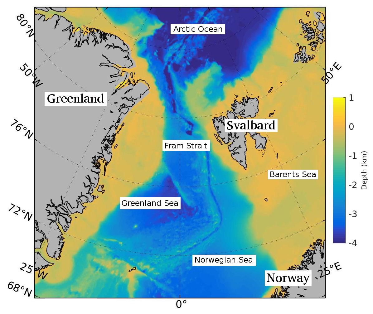
The Fram Strait is the passage between Greenland and Svalbard, located roughly between 77°N and 81°N latitudes and centered on the prime meridian. The Greenland and Norwegian Seas lie south of Fram Strait, while the Nansen Basin of the Arctic Ocean lies to the north. Fram Strait is noted for being the only deep connection between the Arctic Ocean and the World Oceans.[1] The dominant oceanographic features of the region are the West Spitsbergen Current on the east side of the strait and the East Greenland Current on the west.

Description

[edit]

Fram Strait is the northernmost ocean area having ice-free conditions throughout the year.[2] The width of the strait is about 450 km, but because of the wide continental shelves of Greenland and Spitsbergen, the deep portion of Fram Strait is only about 300 km wide. The ocean over the Greenland continental shelf is often covered with ice.

Within Fram Strait, the sill connecting the Arctic and Fram Strait is 2545 m deep. The Knipovich Ridge, the northernmost section of the Mid-Atlantic Ridge, extends northward through the strait to connect to the Nansen-Gakkel Ridge of the Arctic Ocean. A rift valley, caused by sea-floor spreading, runs adjacent and parallel to the Knipovich Ridge. The Molloy Deep within Fram Strait is the deepest point of the Arctic. This small basin at 79°8.5′N and 2°47′E has a maximum depth of 5,550 m (18,210 ft) ±14 m (46 ft)(See also: Litke Deep).[3][4] The Yermak Plateau, with a mean depth of about 650 m, lies to the northwest of Spitsbergen.

Historically, Fram Strait was home to a large population of Bowhead whales, then called the Greenland right whale. By mid-17th century, the Svalbard population of Bowhead whales was reduced to near extinction by excessive whaling (See also: Whaling in Spitsbergen; Smeerenburg).[5] Western Fram Strait may be a wintering ground for this critically endangered population.

Etymology

[edit]

The use of the name "Fram Strait" for the passage between Spitsbergen and Greenland appears to have come into common use in the oceanographic literature in the 1970s.[6] Fram Strait is named after the Norwegian ship Fram. In an 1893 expedition led by Fridtjof Nansen, the Fram drifted for two years across the Arctic before exiting the Arctic through what is now known as Fram Strait. According to glaciologist and geographer Moira Dunbar, an early adopter of the name, the name "Fram Strait" originated in the Russian scientific literature.[7] While in common use, particularly in the oceanographic scientific literature, the name appears to be unofficial.[8]

Oceanography

[edit]

Fram Strait is the only deep-water connection between the World Oceans and the Arctic.[9] Other gateways are the Barents Sea Opening (BSO), the Bering Strait and various small channels in the Canadian Arctic Archipelago. They are all shallower than Fram Strait, leaving Fram Strait the only route by which deep water can be exchanged between the Atlantic and Arctic Oceans. This exchange occurs in both directions, with specific water masses identified with specific regions flowing between the Oceans.[10] Water with characteristics of the deep Canadian and Eurasian Basins of the Arctic are observed leaving the Arctic in the deep western side of Fram Strait, for example. On the eastern side, cold water from the Norwegian Sea is observed entering the Arctic below the West Spitsbergen Current. In recent years the nature and interactions of these water masses have been changing, symptoms of the changes occurring with the ocean's climate.

Current systems

[edit]
Main currents in Fram Strait. The West Spitsbergen Current (red) transports warm and saline water northward. The East Greenland Current (blue) flows southward and transports fresh water (both fluid and sea ice) out of the Arctic Ocean.

Warm, salty water is transported northward from the Atlantic by the West Spitsbergen Current in the east of the strait. The West Spitsbergen Current is the northernmost branch of the North Atlantic Current system. This water forms a water mass called the Atlantic water. The sub-surface flow has a strong seasonality with a minimal volume transport in winter. This current transports internal energy into the Arctic Ocean . The northward velocity is maximum in winter, so the heat transport is highest in winter.

On the west side of the strait, the East Greenland Current flows southward on the Greenland Shelf. The current carries is relatively cold and fresh water out of the Arctic that corresponds to a water mass called Polar water.

The Fram Strait area is located downwind of the Transpolar Drift and therefore covered by multi-year ice in the west of the strait, next to the coast of Greenland. Approximately 90% of sea ice exported from the Arctic is transported by the East Greenland Current.[11] (Sea ice essentially corresponds to fresh water, since its salt content of 4 per mil is much less than the 35 per mil for sea water.) A 2019 estimate states that about "80% of the water exchanged between the Arctic ice cap and the world’s oceans passes through the Fram Strait."[12]

Long-time observations

[edit]

The Alfred Wegener Institute for Polar and Marine Research (AWI) and the Norwegian Polar Institute (NPI) have maintained long term monitoring measurements in Fram Strait to obtain volume- and energy-budgets through this choke point. The observations also serve to assess the development of the Arctic Ocean as a sink for terrestrial organic carbon.[13] The AWI=NPI observing array consists of a line of up to 16 moorings across Fram Strait. The mooring line has been maintained since 1997 with a spacing of roughly 25 km. At up to five different depths, the moored array measures the water velocity, temperature, and salinity of the water column.

Importance for climate

[edit]

Computer simulations suggest that 60 to 70% of the fluctuation of the sea ice flowing through the Fram Strait is correlated with a 6–7 year fluctuation in which the Icelandic Low Pressure system extends eastward into the Barents Sea.[14] The amount of sea ice passing through the Fram Strait varies from year to year and affects the global climate through its influence on thermohaline circulation. The warming in the Fram Strait region has likely amplified Arctic shrinkage, and serves as a positive feedback mechanism for transporting more internal energy to the Arctic Ocean.[15]

In the past century, the sea surface temperature at Fram Strait has on average warmed roughly 1.9 °C (3.5 °F), and is 1.4 °C (2.5 °F) warmer than during the Medieval Warm Period.

References

[edit]
Revisions and contributorsEdit on WikipediaRead on Wikipedia
from Grokipedia
Fram Strait is a broad and deep oceanic passage, approximately 450 kilometers wide with a sill depth of 2700 meters, situated between eastern Greenland and the Svalbard archipelago (including Spitsbergen) in the Arctic region.[1] It connects the Arctic Ocean directly to the Nordic Seas and the North Atlantic Ocean, serving as the sole deep-water conduit for inter-basin exchange in this polar domain.[2] This strait facilitates the primary meridional transport of heat, salt, and freshwater between the Arctic and lower latitudes, profoundly influencing regional and global climate dynamics through the interplay of opposing currents.[3] Warm, saline Atlantic water advances northward via the West Spitsbergen Current along the eastern flank, delivering substantial heat flux into the Arctic basin, while colder, fresher polar surface water and sea ice exit southward in the East Greenland Current on the western side.[2] Over 90% of the Arctic's sea ice export and roughly half of its liquid freshwater outflow occur through this gateway, modulating sea level, ocean ventilation, and the thermohaline circulation.[4] Long-term observations reveal ongoing changes, including enhanced Atlantic water inflow contributing to Arctic warming and reduced sea ice persistence, underscoring the strait's role in amplifying polar amplification effects.[5] The strait's oceanographic significance extends to monitoring deep-water pathways and biogeochemical cycles, with moorings and expeditions documenting variability in volume transports that exceed 20 Sverdrups for Atlantic inflow, balanced by equivalent outflows.[6] These fluxes, governed by wind forcing, buoyancy gradients, and topographic steering, highlight causal mechanisms driving Arctic-Atlantic connectivity without reliance on oversimplified narratives of uniform global forcing.[7]

Geography

Location and Physical Characteristics

The Fram Strait is positioned between the northeastern coast of Greenland and the western margin of the Svalbard archipelago (Spitsbergen), demarcating the boundary between the Arctic Ocean to the north and the Norwegian and Greenland Seas to the south.[8] This configuration places it roughly between 77°N and 81°N latitudes along the prime meridian.[9] The strait spans approximately 450 km in north-south length, with east-west widths varying between 200 and 450 km depending on the section.[10] As the only deep oceanic passage connecting the Arctic Ocean basin—specifically the Eurasia Basin—to the global ocean system via the North Atlantic, the Fram Strait enables the primary exchange of deep water masses between these realms.[11] [12] Its bathymetry features a maximum depth exceeding 2,600 meters in the central trough, allowing unimpeded flow of waters deeper than the sills of alternative pathways like the Barents Sea.[10] [13] The bordering coastlines consist of rugged, glaciated terrain, with Greenland's eastern flank characterized by steep fjords and outlet glaciers, while Svalbard's western shores exhibit similar icy, mountainous profiles indented by deep inlets.[14] Nearby oceanic features include the East Greenland Current along the western boundary and the West Spitsbergen Current in the east, framing the strait's dynamic physical setting.[15]

Geological and Bathymetric Features

The Fram Strait originated from the tectonic separation of the Greenland and Svalbard margins, driven by divergent movements between the North American and Eurasian plates as part of the broader opening of the Norwegian-Greenland Sea. This process involved continental rifting and the propagation of seafloor spreading from the North Atlantic into the Arctic domain, with the strait's gateway initiating in the Early Miocene around 19.5 million years ago.[16] The underlying structure reflects interactions between the ultra-slow-spreading Gakkel Ridge to the north and transform fault systems, which accommodated oblique plate motions and shaped the strait's linear morphology.[8] Bathymetrically, the strait descends to depths generally exceeding 2,500 meters, featuring rugged topography dominated by the Molloy Deep, the Arctic Ocean's deepest basin at approximately 5,600 meters.[17] This depression lies within a complex zone of en echelon ridges, basins, and fracture zones associated with left-lateral shear along the plate boundary, including elements of the Molloy Transform Fault.[17] Sediment cores from the region document a history of intense glacial erosion during Pleistocene ice ages, evidenced by coarse-grained deposits from iceberg rafting and contourite drifts sculpted by paleocurrents, overlain by finer hemipelagic sediments indicating episodic depositional shifts.[18] Tectonically, the Fram Strait maintains relative stability owing to the Gakkel Ridge's spreading rate of less than 1 cm per year, resulting in sparse seismic activity compared to faster-spreading ridges.[19] Recorded events, such as the strongest earthquake in the strait at magnitude around 5, are linked to outside-corner highs at ridge-transform intersections but remain infrequent, underscoring the system's low strain accumulation.[19] Evidence of Paleogene volcanic influences persists in the adjacent margins, though active magmatism is minimal within the strait itself.[20]

History of Exploration

Early Sightings and Mapping

The Fram Strait, separating northeastern Greenland from southwestern Svalbard, entered European awareness through 17th-century whaling pursuits targeting bowhead whales (Balaena mysticetus), which seasonally aggregated in its waters amid abundant krill and open leads.[21] Following the establishment of shore stations on Spitsbergen (Svalbard) in 1611 by the Muscovy Company, British, Dutch, and other whalers navigated the strait's eastern approaches, harvesting whales fleeing westward into the passage, though compacted pack ice confined operations to marginal fringes and precluded thorough exploration.[22] By the mid-17th century, overhunting had reduced bowhead numbers from an estimated 50,000 adults to critically low levels, diminishing sustained whaler traffic and leaving only rudimentary sketches of ice margins in logbooks rather than formal charts.[23] Early 19th-century British whaling intensified observations, with Captain William Scoresby Jr. conducting voyages near the strait's ice edge during summers from 1810 to 1818, documenting whale distributions and ice dynamics from his vessel Resolution.[24] In 1806, Scoresby achieved a then-record latitude of 81°30′N east of Spitsbergen, approaching the strait's northern reaches and noting perennial ice barriers that blocked further ingress, insights he detailed in his 1820 publication An Account of the Arctic Regions with a History and Description of the Northern Whale-Fishery.[25] These accounts, drawn from direct shipboard measurements, highlighted the strait's role in channeling sea ice southward while underscoring navigational perils from fast ice and bergs, informing subsequent whaler tactics but not yet yielding precise positional fixes. Mid-19th-century naval efforts shifted toward systematic charting amid British quests to assess Arctic gateways, with hydrographic surveys compiling whaler logs to outline the strait's approximate 450-kilometer length and variable widths, positioning it as the primary deep-water conduit between the North Atlantic and Arctic Ocean.[26] Persistent multiyear ice export, observed in logbooks from 1820 onward, thwarted accurate bathymetry and coastal delineation until reinforced hulls and steam propulsion enabled safer probes, though early maps remained schematic due to seasonal inaccessibility and reliance on dead reckoning.[26]

Key Expeditions Involving the Fram

The Norwegian ship Fram, meaning "forward," was purpose-built in 1892 by naval architect Colin Archer to withstand extreme ice pressures, featuring a rounded hull and reinforced structure for polar drift expeditions.[27] The Fram Strait, the primary gateway between the Arctic Ocean and the North Atlantic, derives its name from this vessel due to its role in Fridtjof Nansen's pioneering drift across the Arctic pack ice, which validated the trans-Arctic current exiting via the strait.[28] Nansen's Fram expedition (1893–1896) commenced on June 24, 1893, from Vardø, Norway, proceeding eastward along the Siberian coast before entering the pack ice north of the New Siberian Islands on September 22, 1893, at approximately 79° N.[29] The ship drifted westward with the ice for nearly three years, reaching a maximum latitude of 85°57' N by October 16, 1895, while Nansen and Fredrik Hjalmar Johansen sledged toward the North Pole in April 1895, attaining 86°14' N before retreating to Franz Josef Land.[29] The Fram broke free from the ice on August 13, 1896, near Svalbard in the Barents Sea after traversing the Fram Strait region, confirming the feasibility of passive ice drift through the strait without open-water navigation.[30] This voyage provided the first systematic deep oceanographic measurements in the Arctic, including temperature, salinity, and current data from depths exceeding 2,000 meters, revealing the basin's circulatory patterns.[30] Otto Sverdrup commanded the second Fram expedition (1898–1902), departing Norway in June 1898 to explore the Canadian Arctic Archipelago, passing through the Fram Strait en route westward via the Greenland Sea and Smith Sound.[31] Wintering primarily at Harbour Fiord on Ellesmere Island and other sites including Axel Heiberg and the Ringnes Islands, the crew mapped over 100,000 square miles of uncharted territory, including the Sverdrup Islands, through sledge journeys extending to 1901.[31] Though not focused on strait transit, the expedition leveraged Fram's ice resilience to navigate peripheral Arctic waters, contributing geological and ethnographic data from Indigenous contacts.[32] Roald Amundsen repurposed Fram for the third expedition (1910–1912), originally intended for an Arctic North Pole drift akin to Nansen's but redirected secretly to Antarctica, departing Kristiansand on August 9, 1910.[33] Reaching the Bay of Whales on January 14, 1911, Amundsen's party achieved the South Pole on December 14, 1911, before Fram returned via the Pacific in 1912; this southern focus underscored the ship's enduring polar utility but diverged from Arctic strait explorations.[33] Collectively, these voyages proved the strait's role in ice-entrained access to the Arctic interior, informing subsequent drift theories without reliance on mythical open passages.[34]

Oceanography

Surface and Intermediate Water Circulation

The West Spitsbergen Current (WSC) constitutes the primary northward pathway for Atlantic Water in the eastern Fram Strait, transporting warm, saline waters along the western continental slope of Svalbard at volume transports typically ranging from 2 to 3 Sv. This inflow originates from the Norwegian Sea and carries temperatures up to 7°C at the surface in summer and around 4°C in winter, facilitating significant meridional heat exchange into the Arctic Ocean.[35] In opposition, the East Greenland Current (EGC) in the western Fram Strait conveys cold, fresh Polar Surface Water and substantial sea ice volumes southward toward the Greenland Sea, with mean volume transports of approximately 3 to 4 Sv.[7] The EGC incorporates low-salinity waters (salinity <34) and drives the export of Arctic sea ice, which constitutes a key component of the overall freshwater budget through the strait.[36] The interaction between the WSC and EGC generates a dynamic frontal zone characterized by intense mesoscale eddies, recirculation features, and sharp hydrographic gradients, particularly in the central Fram Strait.[37] Seasonal variability modulates these flows, with enhanced velocities during winter attributable to strengthened northerly winds that amplify Ekman transport and barotropic responses.[7] Moored current meter arrays deployed across the strait, such as those maintained since the late 1990s, have quantified the net oceanic heat influx to the Arctic via the WSC at approximately 100 TW on an annual mean basis, largely offset by the southward advection of freshwater in the EGC. These observations underscore the strait's role as a conduit for opposing volume fluxes that maintain quasi-steady intermediate layer exchanges without substantial net volume divergence.[38]

Deep Water Exchange and Ventilation

The Fram Strait serves as the primary conduit for deep water exchange between the Nordic Seas and the Arctic Ocean, facilitating the overflow of dense Greenland Sea Deep Water (GSDW) northward into the Arctic basin primarily through the eastern portion of the strait, where the sill depth reaches approximately 2545 m.[39] This overflow renews the deep layers of the Arctic, contrasting with the warmer Eurasian Basin Deep Water (EBDW) that occupies greater depths and flows southward, with estimates of the southward EBDW flux through the strait at about 1 Sverdrup (Sv) based on hydrographic sections and volume transport analyses.[40] These counterflowing deep currents establish a critical linkage in the global thermohaline circulation, whereby GSDW ventilation supports Arctic bottom water renewal while EBDW export contributes to Nordic Seas density and overturning dynamics.[41] Ventilation of deep Arctic waters occurs through a combination of advective overflow and internal mixing processes, including double-diffusive convection that promotes diapycnal exchange between layered water masses.[42] In the Eurasian Basin, double-diffusive staircases—characterized by warmer, saltier layers overlying colder, fresher ones—facilitate upward heat and downward salt fluxes, effectively renewing stagnant deep waters over timescales of decades, with transport rates in these interfaces contributing significantly to basin-wide homogenization.[42] Hydrographic observations indicate that such mixing, augmented by shear-driven turbulence near the strait, sustains deep water properties against isolation, though rates remain modest at around 1 Sv for net deep exchange, underscoring the strait's role in limiting full basin ventilation compared to shelf-driven processes elsewhere in the Arctic.[40] Bathymetric features, including the Greenland Fracture Zone and associated transverse ridges like the Hovgaard and Molloy Fracture Zones, constrain deep pathways by creating sills and channels that channelize overflow plumes and promote topographic steering of deep currents.[19] These structures, part of the ultraslow-spreading ridge system in the strait, influence the lateral distribution of deep flows, with the eastern sill enabling GSDW spillover while western barriers enhance recirculation and eddy formation in intermediate depths.[43] Observations from deep floats and submarine surveys have documented sporadic deep eddies, which transport anomalous water properties along fracture-guided paths, adding variability to the otherwise steady deep exchange and highlighting the interplay between topography and mesoscale dynamics in modulating ventilation efficiency.[44]

Long-term Observational Programs

The Alfred Wegener Institute (AWI) and Norwegian Polar Institute (NPI) jointly operate a mooring array across Fram Strait at approximately 78°50′N, deployed since 1997 with up to 16 full-depth moorings spaced about 20–30 km apart between the shelf edges.[45][46] Instruments include acoustic Doppler current profilers for velocity, conductivity-temperature-depth sensors for hydrography, and pressure gauges, yielding time series of volume, heat, and freshwater transports through the strait.[37] This array, part of the Arctic-Subarctic Ocean Fluxes (ASOF) program, focuses on the West Spitsbergen Current in the eastern strait and complements NPI's western array monitoring the East Greenland Current.[47][48] The NPI-led Fram Strait Arctic Outflow Observatory, active since the early 1990s, maintains 8–15 moorings in the western strait to observe Arctic outflow, including recirculating Atlantic Water layers, with measurements of temperature, salinity, currents, and sea ice interactions.[49][50] Upward-looking sonars integrated into these moorings have recorded sea ice draft continuously since 1990, typically at 1–2 second resolution, supporting estimates of ice thickness and export variability.[51][52] These in-situ records, exceeding 25 years in duration, are supplemented by satellite altimetry for sea surface height anomalies and Argo floats for profiling temperature and salinity in ice-free periods, providing synoptic context to moored data for analyzing circulation patterns.[53][54] The combined datasets facilitate quantification of interannual to decadal fluctuations in water mass properties and fluxes without reliance on short-term snapshots.[12]

Role in the Arctic Climate System

Sea Ice Export Dynamics

The Fram Strait constitutes the principal pathway for Arctic sea ice export, channeling approximately 90% of the total sea ice outflow from the Arctic Ocean into the Greenland Sea and North Atlantic.[55] Empirical estimates derived from upward-looking sonar (ULS) moorings for ice thickness and satellite observations for ice area flux yield an average annual volume export of 2,400 ± 640 km³ over the period 1992–2014, representing about 14% of the Arctic's total sea ice volume annually when benchmarked against model simulations.[56] This flux is propelled by southward ice drift speeds averaging 0.1–0.5 m/s, governed by the geostrophic flow of the East Greenland Current and transient wind forcing across the strait, with ULS arrays at ~78.8–79°N providing direct measurements of ice draft to compute volume alongside satellite-derived drift vectors.[56] [57] A modal decline in ice thickness of ~21% per decade, alongside a mean thickness reduction of 15%, has characterized the exported ice pack, reflecting broader Arctic thinning that offsets gains in drift speed and partially stabilizes volume export against accelerating area flux.[56] This dynamic export mechanism depletes multiyear ice reserves in the Arctic interior, exerting a thinning feedback on regional mass balance, while the southward advection of ice modulates hemispheric albedo by redistributing reflective cover to warmer latitudes where rapid melt ensues.[56] Validation relies on moored ULS profiles for draft (converted to thickness assuming ~0.9 density) and cross-validated satellite tracking of Lagrangian buoys or feature vectors for drift continuity.[56] Export exhibits pronounced episodic variability rather than monotonic trends, as evidenced by the 2010–2011 peak, when multiyear ice volume outflow surged amid extreme preconditioned thickness losses in the Arctic basin, exporting older ice classes that had persisted through prior summers.[58] Conversely, 2018 recorded an unprecedented minimum, with volume flux dropping below 40% of the 2000–2017 mean, driven by anomalously thin incoming ice (declining sharply en route to the strait) compounded by subdued drift from weak cross-strait pressure gradients and reduced wind speeds.[55] Such events underscore the strait's role in nonlinear ice loss pathways, where thickness preconditioning and transient kinematics dominate over linear atmospheric trends.[55] [58]

Heat, Salt, and Freshwater Fluxes

The Fram Strait facilitates a net northward oceanic heat transport into the Arctic Ocean, predominantly via the Atlantic Water inflow along the West Spitsbergen Current, which couples with atmospheric processes to modulate regional energy balances. Observational estimates derived from moored arrays and hydrographic sections indicate an annual mean heat flux of approximately 26 terawatts (TW) in 1998, rising to 50 TW by 2004, underscoring interannual and decadal variability linked to velocity and temperature anomalies in the inflow rather than uniform trends.[59] [60] This transport contributes to offsetting Arctic surface heat losses, primarily through sensible and latent heat exchanges at the ocean-atmosphere interface, with empirical data showing modulations tied to density contrasts predating intensive post-1950s monitoring.[61] Net freshwater export through the Fram Strait totals around 2,700 ± 530 km³ per year (relative to a reference salinity of 34.8), encompassing liquid components from the East Greenland Current and contributions from ice melt, exerting a downstream influence on Nordic Seas convection by altering surface buoyancy.[62] This export variability, driven by wind-forced volume transport and Arctic Ocean storage changes, empirically correlates with large-scale atmospheric patterns and density gradients, with records indicating fluctuations as early as the late 20th century that precondition salinity stratification without reliance on singular causal attributions.[7] [63] Salt fluxes exhibit net import to the Arctic due to the higher salinity of Atlantic inflows compared to outflows, with variability on seasonal to decadal scales modulating deep water formation in the Greenland Sea through alterations in overflow density. Denser Arctic-derived waters exiting the strait enhance gyre overturning via gravitational adjustment, grounded in observed potential density gradients that sustain convective chimneys, independent of overlaid interpretive frameworks emphasizing recent forcings alone.[64] [37] These dynamics underscore causal linkages between meridional salinity contrasts and vertical mixing, with hydrographic data confirming preconditioning effects traceable to pre-1950s hydroclimate shifts.[3]

Linkages to Large-scale Atmospheric Variability

The North Atlantic Oscillation (NAO), a primary mode of atmospheric variability in the North Atlantic sector, modulates sea ice export and associated fluxes through the Fram Strait primarily via alterations in wind patterns and sea level pressure gradients. During the positive NAO phase, strengthened northerly winds over the strait enhance southward ice motion and volume flux, with empirical correlations between the winter NAO index and Fram Strait ice area export reaching approximately 0.86 for December–February periods in satellite-era data (1979–present). This linkage arises from the NAO's influence on the position and strength of the polar jet stream, which shifts eastward in positive phases, promoting anomalous meridional winds that drive Ekman transport of ice southward.[65][66] Historical analyses reveal regime-dependent behavior in these connections: correlations between NAO and Fram Strait ice export were near zero from 1958 to 1977 but strengthened to around 0.6 thereafter, coinciding with shifts in atmospheric circulation patterns that amplified wind-driven export variability. This non-stationarity underscores the role of internal atmospheric dynamics over fixed forcing, as evidenced by reanalysis datasets showing that cross-strait sea level pressure differences—proxies for geostrophic wind forcing—account for much of the interannual flux variance, with dipole-like patterns enhancing export during high-index states. Such empirical patterns indicate that NAO-driven teleconnections can dominate short-term flux anomalies, independent of longer-term trends.[67][68][69] Wind forcing via Ekman transport mechanisms further links large-scale atmospheric variability to strait dynamics, where along-strait wind anomalies induce convergence or divergence in the surface layer, propelling ice and upper-ocean waters southward. Studies using daily reanalysis (1979–2007) confirm that anomalous wind stress curl north of Greenland–Svalbard drives much of the observed ice speed variability, with jet stream undulations—tied to NAO and blocking patterns—altering local wind fields and thus export rates. These wind-dominated processes highlight causal pathways where atmospheric internal variability, rather than deterministic oceanic adjustments, primarily governs flux intermittency, as supported by correlations exceeding 0.8 between wind-forced models and observed motions. Atmospheric teleconnections thereby amplify Arctic regional variability, emphasizing empirical wind-ice coupling over singular attributions to radiative forcing.[70][71][72]

Environmental Changes and Debates

Historical and Paleoclimate Variability

Sediment cores from the Fram Strait provide proxy records of sea ice extent and oceanographic conditions spanning the last glacial-interglacial transition, revealing recurrent fluctuations driven by changes in ice sheet dynamics and ocean circulation rather than anthropogenic factors. During the Last Glacial Maximum (approximately 23.5–17 ka BP), perennial sea ice cover predominated, as evidenced by low fluxes of IP25 (a biomarker from sea ice diatoms) and associated phytoplankton markers in cores from the eastern Fram Strait, indicating limited algal productivity under thick ice. Deglaciation phases showed abrupt shifts: ice thinning around 17–15 ka BP allowed increased IP25 production, followed by near ice-free conditions during the Bølling warm phase (~14.8–14.6 ka BP), while the Younger Dryas (~12.7–11.7 ka BP) marked a return to expanded ice with elevated IP25 levels. Dinocyst assemblages from northeastern cores further document low sea-surface salinity from glacial meltwater inputs and enhanced Arctic water influence during these transitions, with an abrupt warming peak at 14.7–14.5 ka BP tied to Svalbard-Barents Sea ice sheet disintegration.[73][74] Holocene reconstructions from planktic foraminiferal Mg/Ca ratios and IP25 indices indicate early to mid-Holocene warmth with reduced sea ice export, transitioning to Neoglacial cooling and oscillations. Sea surface temperatures in the eastern Fram Strait averaged ~4°C from ~10.5–7.9 ka BP, reflecting intensified Atlantic Water advection under high Northern Hemisphere insolation, with minor sea ice coverage along West Spitsbergen. After ~7.9 ka BP, temperatures declined to ~3°C amid decreasing insolation and reduced heat transport, culminating in stable ice margin conditions by ~1 ka BP and increased coverage on the East Greenland Shelf. IP25-based proxies show seasonal spring ice persisting through the Holocene, with mid-Holocene minima linked to orbital forcing and maximal advection, while late Holocene expansions correlate with Neoglacial trends and NAO-like atmospheric variability rather than CO2 dominance. Foraminiferal evidence confirms variable subsurface Atlantic influence without reliance on modern greenhouse gas levels.[75][76][73] Longer-term paleodata from eastern Fram Strait cores extend to the penultimate glacial (late Marine Isotope Stage 6, ~140 ka BP) through early Stage 5b (~90 ka BP), documenting sea ice advances and retreats independent of industrial-era CO2, with causal roles for orbital parameters and Atlantic Meridional Overturning Circulation (AMOC) strength modulating heat and freshwater fluxes. These cycles highlight the strait's sensitivity to natural forcings, including enhanced Atlantic inflows during interstadials akin to historical Atlantification episodes around 800 years ago, as reconstructed from multi-proxy records showing pulsed warm-water intrusions without exceptionalism relative to prior fluctuations. Empirical proxies like IP25 and foraminifera thus underscore intrinsic variability in ice-ocean interactions over millennia, contextualizing the Fram Strait's role in Arctic paleoclimate dynamics.[77][73]

Recent Observations of Warming and Atlantification

Instrumental observations since the 1980s have revealed pronounced warming in the Atlantic Water (AW) layer within Fram Strait, especially along the eastern boundary where the West Spitsbergen Current carries heat northward. Mooring arrays deployed from 1997 onward recorded a marked temperature rise in AW, with mean annual increases of approximately 0.07°C in the core layer through 2010, accumulating to nearly 1°C by the mid-2010s in the eastern strait.[78][79] This warming reflects enhanced AW advection, with heat content anomalies propagating eastward into the Arctic interior.[80] Deep water masses have exhibited more subdued but consistent warming. Eastern Basin Deep Water (EBDW) temperatures rose by about 0.1°C from the 1980s to 2024, while Greenland Sea Deep Water (GSDW) increased by 0.4–0.5°C over the same interval, at rates of roughly 0.05°C per decade for EBDW and 0.11°C per decade for GSDW.[12] By 2017–2018, GSDW had become warmer than EBDW, shifting the relative heat dynamics across the strait.[12] Atlantification signatures include the eastward migration of these warm anomalies and freshening in upper inflows linked to surface layer adjustments, though deep salinification accompanies the AW expansion.[81][82] Analyses through 2024 affirm continued modest deep warming without evidence of uniform acceleration region-wide, as spatial distinctions persist between eastern AW cores and western outflows.[12] Salinity records show variable freshening in polar surface waters amid AW intrusion, contributing to stratified responses.[83] However, interannual variability often dominates short-term records: for example, sea ice volume export dropped to under 40% of the 2000–2017 mean in 2018 (approximately 590 km³ yr⁻¹), driven by localized thinning (0.74 m reduction) and reduced drift speeds rather than a steady thinning progression.[55] Such fluctuations highlight how dynamic processes can mask or amplify trends in limited datasets.[55]

Controversies in Interpretation and Geoengineering Proposals

The relative contributions of atmospheric wind forcing and internal sea ice dynamics to Fram Strait export variability remain contested. Studies utilizing satellite and mooring data indicate that wind patterns, particularly those linked to the North Atlantic Oscillation (NAO), exert a dominant control on ice drift and export volume, with correlations between winter NAO indices and export rates reaching R²=0.62 excluding extreme negative NAO years.[84] However, internal ice mechanics, including thickness reductions and fracturing, precondition low-export events by altering resistance to drift, as evidenced in analyses of 1992–2014 upward-looking sonar records showing a 15–21% per-decade decline in modal ice thickness coinciding with variable export.[56][85] Climate models, including those from CMIP6 ensembles, exhibit biases in reproducing Fram Strait fluxes, often underestimating the persistence of thick ice or overpredicting linear declines in export under warming scenarios, which hampers reliable projections of Arctic sea ice minima.[86] For instance, CMIP simulations struggle to capture interannual variability driven by ice-ocean feedbacks, leading to discrepancies with observational benchmarks from programs like the Alfred Wegener Institute's moored arrays, which have documented positive trends in Atlantic Water heat flux since 1997 alongside episodic export drops.[46] These model shortcomings underscore debates over whether observed trends reflect predominantly anthropogenic CO2 forcing or amplified natural oscillations like the Atlantic Multidecadal Oscillation (AMO), which modulates summer ice extent through altered circulation patterns.[87] The 2018 export minimum, the lowest since the early 1990s at approximately 90% below average Fram Strait outflow, exemplifies how transient atmospheric blocking and reduced ice motion can interrupt multi-decadal declines, challenging attributions of unidirectional "atlantification" without accounting for such variability.[55] Paleoclimate proxies further support this, revealing extreme export pulses around 1300 CE—preceding industrial emissions—that mirror modern anomalies in magnitude, driven by comparable NAO-like shifts rather than greenhouse gas linearity.[88] Interpretations favoring unmitigated anthropogenic dominance have drawn criticism for sidelining these empirical precedents and over-relying on model outputs prone to equilibrium biases, potentially influenced by institutional preferences for alarm-oriented narratives in academic and media sources.[86] Fringe geoengineering proposals, such as erecting a "Fram Dam"—a conceptual barrier across the strait to curtail ice outflow and promote basin retention—emerged in informal discussions around 2013, positing that impeding export could stabilize Arctic ice volumes amid thinning.[89] Advocates suggest localized ice buildup via reduced advection, but causal analysis of circulation reveals implausibility: prevailing easterly winds and geostrophic currents, sustaining mean exports of 2,400 km³ annually, would likely overwhelm artificial obstructions, risking upstream ice jamming, downstream fragmentation, and broad disruptions to Atlantic Water inflow critical for heat balance.[56] Empirical precedents from monitoring arrays confirm the strait’s dynamic resilience, rendering such interventions unproven and ecologically hazardous without addressing root thermodynamic drivers of melt.[46] Skeptics, emphasizing observed circulation vigor over speculative engineering, highlight violations of oceanographic first principles, where blocking gateways historically amplifies feedbacks like enhanced upwelling rather than preservation.[55]

References

User Avatar
No comments yet.