Recent from talks
Laccadive Sea
Knowledge base stats:
Talk channels stats:
Members stats:
Laccadive Sea
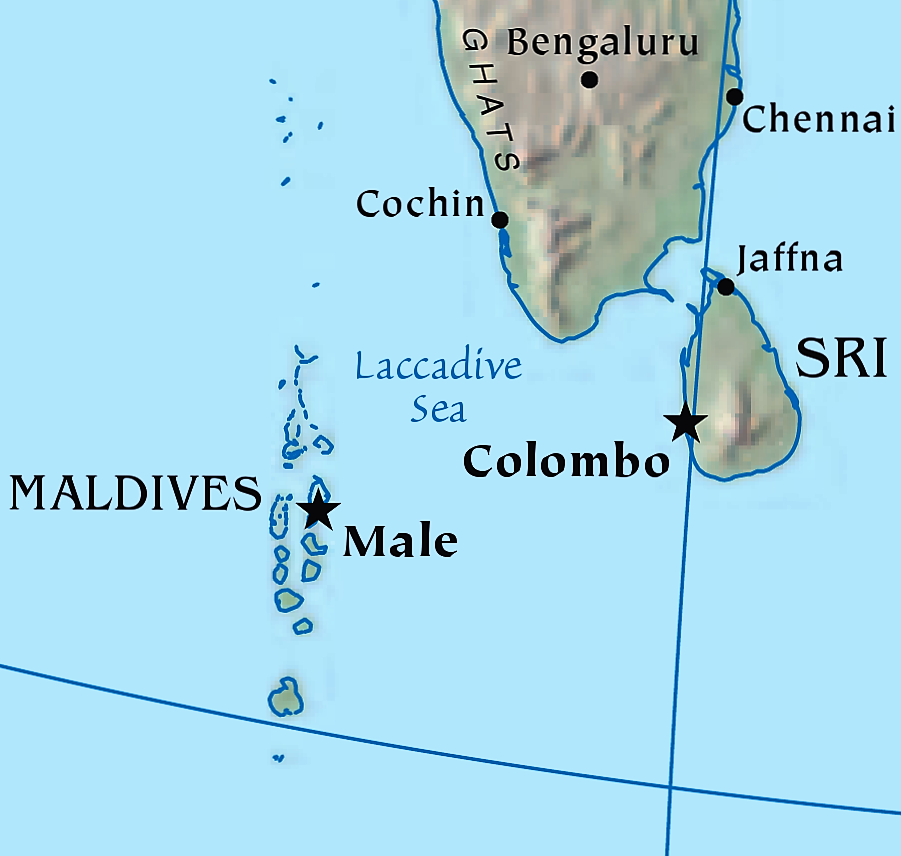
The Laccadive Sea (/ˈlɑːkədiːv, ˈlækə-/ LAH-kə-deev, LAK-ə-), also known as the Lakshadweep Sea, is a body of water bordering India (including its Lakshadweep islands), the Maldives, and Sri Lanka. It is located to the southwest of Karnataka, to the west of Kerala and to the south of Tamil Nadu. This warm sea has a stable water temperature through the year and is rich in marine life, the Gulf of Mannar alone hosting about 3,600 species. Mangaluru, Kasaragod, Kannur, Kozhikode, Ponnani, Kochi, Alappuzha, Kollam, Thiruvananthapuram, Tuticorin, Colombo, Negombo and Malé are the major cities on the shore of the Laccadive Sea. Kanyakumari, the southernmost tip of peninsular India, also borders this sea. It is named for the Laccadive Islands located in the northwest portion of the sea.
The International Hydrographic Organization defines the limits of the Laccadive Sea as follows:
On the West. A line running from Sadashivgad Lt. on West Coast of India (14°48′N 74°07′E / 14.800°N 74.117°E) to Corah Divh (13°42′N 72°10′E / 13.700°N 72.167°E) and thence down the West side of the Laccadive and Maldive Archipelagos to the most Southerly point of Addu Atoll in the Maldives.
On the South. A line running from Dondra Head in Sri Lanka to the most Southerly point of Addu Atoll.
On the East. The West coasts of Sri Lanka and India.
On the Northeast. Adams Bridge (between India and Sri Lanka).
Water temperature is rather constant through the year, averaging 26–28 °C in summer and 25 °C in winter. Salinity is 34‰ (parts per thousand) in the center and northern part and up to 35.5‰ in the south. The coasts are sandy and the deeper parts covered in silt. There are numerous coral reefs in the sea, such as the Lakshadweep islands which are made up of atolls and contain 105 coral species.
With about 3,600 species of flora and fauna, the Gulf of Mannar is regarded as one of the richest marine biological resources in the world. Of these 3,600 species, 44 are protected, 117 are corals, 79 crustaceans, 108 sponges, 260 mollusks, 441 fin fishes, 147 seaweeds and 17 mangroves. In 1986, a group of 21 islands and nearby waters with a total area of 560 km2 were declared as the Gulf of Mannar Marine National Park. The park and its buffer zone were designated as a Biosphere Reserve in 1989. The Gulf of Mannar Biosphere Reserve covers an area of 10,500 km2 of ocean, islands and the adjoining coastline, and is the largest such reserve in India. Most of its area is restricted for outsiders and the access of boats is subject to strict rules, but local people continue fishing activities which they crucially depend on.
Hub AI
Laccadive Sea AI simulator
(@Laccadive Sea_simulator)
Laccadive Sea
The Laccadive Sea (/ˈlɑːkədiːv, ˈlækə-/ LAH-kə-deev, LAK-ə-), also known as the Lakshadweep Sea, is a body of water bordering India (including its Lakshadweep islands), the Maldives, and Sri Lanka. It is located to the southwest of Karnataka, to the west of Kerala and to the south of Tamil Nadu. This warm sea has a stable water temperature through the year and is rich in marine life, the Gulf of Mannar alone hosting about 3,600 species. Mangaluru, Kasaragod, Kannur, Kozhikode, Ponnani, Kochi, Alappuzha, Kollam, Thiruvananthapuram, Tuticorin, Colombo, Negombo and Malé are the major cities on the shore of the Laccadive Sea. Kanyakumari, the southernmost tip of peninsular India, also borders this sea. It is named for the Laccadive Islands located in the northwest portion of the sea.
The International Hydrographic Organization defines the limits of the Laccadive Sea as follows:
On the West. A line running from Sadashivgad Lt. on West Coast of India (14°48′N 74°07′E / 14.800°N 74.117°E) to Corah Divh (13°42′N 72°10′E / 13.700°N 72.167°E) and thence down the West side of the Laccadive and Maldive Archipelagos to the most Southerly point of Addu Atoll in the Maldives.
On the South. A line running from Dondra Head in Sri Lanka to the most Southerly point of Addu Atoll.
On the East. The West coasts of Sri Lanka and India.
On the Northeast. Adams Bridge (between India and Sri Lanka).
Water temperature is rather constant through the year, averaging 26–28 °C in summer and 25 °C in winter. Salinity is 34‰ (parts per thousand) in the center and northern part and up to 35.5‰ in the south. The coasts are sandy and the deeper parts covered in silt. There are numerous coral reefs in the sea, such as the Lakshadweep islands which are made up of atolls and contain 105 coral species.
With about 3,600 species of flora and fauna, the Gulf of Mannar is regarded as one of the richest marine biological resources in the world. Of these 3,600 species, 44 are protected, 117 are corals, 79 crustaceans, 108 sponges, 260 mollusks, 441 fin fishes, 147 seaweeds and 17 mangroves. In 1986, a group of 21 islands and nearby waters with a total area of 560 km2 were declared as the Gulf of Mannar Marine National Park. The park and its buffer zone were designated as a Biosphere Reserve in 1989. The Gulf of Mannar Biosphere Reserve covers an area of 10,500 km2 of ocean, islands and the adjoining coastline, and is the largest such reserve in India. Most of its area is restricted for outsiders and the access of boats is subject to strict rules, but local people continue fishing activities which they crucially depend on.
Recent media