

Community hub
Recent from talks
Contribute something
Nothing was collected or created yet.
Shikotan
View on WikipediaShikotan, also known as Shpanberg or Spanberg, is an island in the Kurils administered by the Russian Federation as part of Yuzhno-Kurilsky District of Sakhalin Oblast. It is claimed by Japan as the titular Shikotan District (色丹郡, Shikotan-gun), organized as part of Nemuro Subprefecture of Hokkaido Prefecture. The island's primary economic activities are fisheries and fishing, with the principal marine products being cod, crab, and kelp.
Key Information


Names
[edit]The English name Shikotan transcribes both the Japanese name 色丹 and the Russian name Шикотан. The Japanese name derives from the Ainu Sikotan (シコタン or シコタヌ). The name combines the Ainu reflexive or embellishing prefix si- and the word kotan ("settlement, village"), used metonymically in Ainu for each of the islands of the Kurils.
The alternative Russian name Shpanberg (Шпанберг), sometimes anglicized as Spanberg, honors Martin Spanberg, one of Vitus Bering's lieutenants who led three voyages in 1738, 1739, and 1742 that first initiated Russian diplomatic relations with Japan and helped accelerate Russian control of the Kurils.
Geography
[edit]The total land area of Shikotan is 225 square kilometers (87 sq mi). The island is hilly, averaging 300 metres (984 ft) in elevation. The highest elevation is 412 metres (1,352 ft). The shores of the island are very indented and covered with oceanic meadows. The island is formed by the volcanic rock and sandstone of the Upper Cretaceous and Cenozoic periods. There are two extinct volcanoes on Shikotan: Mount Tomari and Mount Notoro. A number of tiny islets and rocks are scattered around the coast of Shikotan. Two larger islands lie off the south coast: Griega island; and Aivazovskogo island which lies in a bay near the western end of the southern coast.
Shikotan's vegetation consists mostly of Sakhalin fir, larch, deciduous trees, bamboo underbrush, and juniper brushwood.
There are two villages: Malokurilskoye, formerly Shikotan (色丹); and Krabozavodskoye, formerly Anama (穴澗)
History
[edit]Russia recognised Japanese sovereignty over the island in the 19th century under Shimoda Treaty. In 1885, Hanasaki District, to which the island belongs, was split off of Nemuro Province and incorporated into Chishima Province.[citation needed]
On 1 September 1945, during the final days of World War II, the island, which had a population of 1,038 at the time,[citation needed] was invaded by 600 Soviet troops during the Soviet invasion of the Kuril Islands.[1] It is one of the islands (along with the Habomai Islands) which the Soviet Union agreed in 1956 to transfer to Japan in the event of a peace treaty between the two countries, but such a peace treaty has never been concluded.[2] During the late 1950s and the 1960s, the Soviet Union fortified the island against a possible seaborne invasion by repurposing old tanks (mainly IS-2 and IS-3 heavy tanks) as coastal artillery, digging them into the ground to serve as fixed gun emplacements.[3]
On 6 November 1958, a magnitude 8.3 to 8.4 earthquake in the Pacific Ocean off Iturup in the Kuril Islands generated a tsunami with a height of up to 5 metres (16.4 ft) at Shikotan.[4] A magnitude 8.3 earthquake in the Pacific Ocean just off Shikotan and subsequent tsunami on 4 October 1994 caused major damage on the island's coastline. The tsunami had a run-up height of as much as 10 metres (33 ft) on Shikotan.[5]
In popular culture
[edit]The 2014 anime film Giovanni's Island is a fictionalized account of the fate of Japanese civilians living on Shikotan at the time of the 1945 Soviet occupation.
Gallery
[edit]-
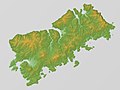 Relief Map
 -
 Shikotan Island, 1990.
 -
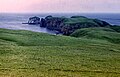
 Shikotan, 1980.
 -
 Lighthouse, 1980.
 -
 Landscape, 1980.
 -


See also
[edit]References
[edit]- ^ "Japan's prime minister plans a steamy tête-à-tête with Russia's president". The Economist. 10 September 2016. Retrieved 8 April 2018.
- ^ "Russia PM visits disputed isle off Japan's Hokkaido". english.kyodonews.net. 27 July 2021. Retrieved 19 March 2023.
- ^ "Texts of Soviet–Japanese Statements; Peace Declaration Trade Protocol". The New York Times, page 2, October 20, 1956.
Moscow, October 19. (UP) – Following are the texts of a Soviet–Japanese peace declaration and of a trade protocol between the two countries, signed here today, in unofficial translation from the Russian
...The U.S.S.R. and Japan have agreed to continue, after the establishment of normal diplomatic relations between them, negotiations for the conclusion of a peace treaty. Hereby, the U.S.S.R., in response to the desires of Japan and taking into consideration the interest of the Japanese state, agrees to hand over to Japan the Habomai and the Shikotan Islands, provided that the actual changing over to Japan of these islands will be carried out after the conclusion of a peace treaty...
- ^ "Catalog of Tsunamis in Japan and Its Neighboring Countries". Tsunami Digital Library. Retrieved 30 July 2023.
- ^ "M 9.0 – 89 km ESE of Petropavlovsk-Kamchatsky, Russia". United States Geological Survey Earthquake Hazards Program. Retrieved 25 November 2024.
External links
[edit]- Kuril Island Network – A volunteer group dedicated to raising awareness of the habitat on the Kurils
- Satellite image of Shikotan
- Ainu speaker and activist explains the meaning of the South Kuril island names
| International | |
|---|---|
| National | |
Shikotan
View on GrokipediaShikotan is a rugged, volcanic island located in the southern Kuril Islands archipelago of the northwestern Pacific Ocean, forming the largest component of the Lesser Kuril Chain. With an area of 251 km² and elevations averaging 300 meters dominated by verdant hills and alpine vegetation, its highest point is Mount Tomari at 412 meters. The island supports a population of approximately 2,100 residents primarily in the settlement of Malokurilskoye, whose economy revolves around fisheries targeting cod, crab, and kelp. Administered by Russia as part of the Yuzhno-Kurilsky District in Sakhalin Oblast since the Soviet occupation at the end of World War II, Shikotan is claimed by Japan as inherent territory within Hokkaido's Nemuro Subprefecture, distinct from the Kuril Islands proper ceded under the 1951 San Francisco Treaty, forming a core element of the unresolved Northern Territories dispute that blocks a Russo-Japanese peace treaty.[1][2][3][4]
Nomenclature
Etymology and Linguistic Origins
The name Shikotan originates from the Ainu language spoken by the indigenous peoples of the Kuril Islands region, specifically from the term sikotan (シコタン), a compound of the prefix si-—an emphatic, reflexive, or possessive element—and kotan, denoting "village," "settlement," or metonymically "island" in reference to its primary human habitation.[5] This structure reflects Ainu toponymic conventions, where islands were named for their chief settlements, implying a sense of prominence or authenticity, often popularly rendered in English sources as "the great village" or "the best island."[6] [7] In Japanese administration, the island is designated Shikotan-tō (色丹島), utilizing ateji—kanji characters selected primarily for phonetic approximation of the Ainu name rather than literal meaning; here, shiko (色, "color") and tan (丹, "vermilion" or "cinnabar") do not convey semantic content tied to the island's attributes but serve to transcribe sikotan. The Russian transliteration Shikotan (Шикотан) follows similarly from the Ainu root via historical cartographic adoption during Russian exploration of the Kurils in the 18th and 19th centuries.[5] No evidence supports alternative derivations from Japanese or Russian linguistic roots independent of Ainu influence, underscoring the island's prehistorical ties to Ainu inhabitation predating Yamato Japanese or Slavic expansions.Designations in Russian and Japanese Administrations
In Russian administration, Shikotan is officially designated as остров Шикотан (Ostrov Shikotan, "Shikotan Island") and integrated into the Yuzhno-Kurilsky District (Южно-Курильский район) of Sakhalin Oblast, encompassing the southernmost Kuril Islands such as Kunashir, Shikotan, and the Habomai group, with administrative functions centered in Yuzhno-Kurilsk on Kunashir since the post-1945 Soviet incorporation.[8][9] This structure reflects Russia's assertion of sovereignty over the Lesser Kuril Chain, treating the islands as federal territory without concession to Japanese claims except in limited bilateral contexts like the 1956 Soviet-Japanese Joint Declaration, which referenced potential transfer of Shikotan but was not implemented.[10] In Japanese administration, despite lacking de facto control since 1945, Shikotan is designated as 色丹島 (Shikotan-tō, "Shikotan Island") and organized under Shikotan District (色丹郡, Shikotan-gun), which includes the uninhabited Shikotan Village (色丹村, Shikotan-mura) and adjacent islets like Oshima, Kojima, and Tanoshima, falling within Nemuro Subprefecture (根室支庁, Nemuro-shichō) of Hokkaido Prefecture.[2][11] This titular framework originates from pre-war Japanese governance, where Shikotan-gun was established around 1885 after prior affiliations with Hanasaki-gun, and Japan maintains it as an inherent part of its territory under the Northern Territories framework, rejecting Russian administration as illegal occupation.[12][13]Physical Geography
Location, Topography, and Geology
Shikotan is situated in the northwestern Pacific Ocean as the largest and southernmost island of the Lesser Kuril Chain within the Kuril Islands archipelago, positioned at coordinates 43°48′N 146°45′E. The island spans a land area of 225 km² and lies approximately 15 km east of Nemuro Peninsula on Hokkaido, Japan, and about 350 km southeast of Sakhalin Island, Russia. It forms part of the boundary between the Sea of Okhotsk to the northwest and the open Pacific to the southeast.[6][14] The topography of Shikotan is characterized by hilly terrain with an average elevation of 300 meters, featuring gently rolling hills rather than steep volcanic peaks typical of northern Kuril islands. The highest point is Mount Shakotan, reaching 413 meters above sea level. The island's coastline is highly indented, forming numerous bays, coves, and oceanic meadows that enhance its irregular outline. These features contribute to a diverse shoreline suitable for sheltered anchorages.[14][15] Geologically, Shikotan belongs to the Kuril volcanic island arc system, resulting from the subduction of the Pacific tectonic plate beneath the Okhotsk microplate of the North American Plate along the Kuril-Kamchatka Trench. The island's structure includes widespread parallel dikes of basalts and andesites, predominantly in the eastern sector, indicative of extensional tectonics with four identified centers of rifting. Paleomagnetic studies reveal Upper Cretaceous formations, with Miocene arc-continent collision events shaping its position against the Eurasian margin around 15 million years ago. Unlike more northern Kuril islands, Shikotan lacks prominent active volcanoes, reflecting its position in the accretionary prism zone of the arc.[16][17][18]Climate, Biodiversity, and Environmental Features
Shikotan possesses a subarctic climate (Köppen Dfc), with cool, foggy summers and cold, snowy winters moderated by oceanic influences. Average annual precipitation measures 1,000 to 1,500 millimeters, predominantly from June to September, while rainfall occurs year-round, peaking at about 132 millimeters in September. Winter conditions feature relatively mild temperatures, averaging -6.5°C in February, warmer than comparable inland areas of Hokkaido due to the warm Tsushima Current.[19][20][21] The island's biodiversity reflects its position in the transition zone between continental Asian and Pacific ecosystems, supporting mixed forests of coniferous species like fir alongside broadleaf trees, whose proportions have increased with historical warming episodes. Vascular flora includes over 300 documented spermatophytes and pteridophytes from early surveys, with recent expeditions adding five species and two hybrids to the known list. Lichens are particularly diverse, with 278 species and allied fungi recorded, including rarities new to Eurasia or Russia. Alien plant species, numbering at least 21 confirmed introductions, pose potential ecological pressures.[22][23][24][25][26] Faunal assemblages include terrestrial mammals such as brown bears (Ursus arctos) and Ezo red foxes (Vulpes vulpes schrencki), alongside marine species like seals and sea otters (Enhydra lutris). Avian diversity features seabirds including tufted puffins (Fratercula cirrhata), spectacled guillemots (Cepphus carbo), rhinoceros auklets (Cerorhinca monocerata), and white-tailed eagles (Haliaeetus albicilla), with habitats supporting nesting colonies. Invertebrates, such as ground beetles, comprise 68 species on the island. The surrounding waters host rich marine life, contributing to the overall ecosystem connectivity.[21][27][28] Environmental features encompass volcanic topography with rugged mountains, deep fjords, and coastal zones fostering kelp forests and spawning grounds for fish. Approximately two-thirds of Shikotan falls within the Kurilsky State Nature Reserve, aiding preservation of endemic and migratory species amid the territorial dispute. Sea ice occasionally surrounds the island in winter, influencing local climate and access.[29]Human Geography and Economy
Population and Settlements
Shikotan is home to two principal settlements: Malokurilskoye, the administrative center located on the island's east coast, and Krabozavodskoye (also known as Anama in Japanese nomenclature), situated near the southern shore. These villages developed primarily after the Soviet repopulation efforts post-1945, replacing the pre-war Japanese communities that were evacuated during 1946–1947. Malokurilskoye functions as the local hub for administration, education, and basic services, while Krabozavodskoye historically supported fishing operations, though its namesake crab processing facility was never established.[31][7] The island's total population stands at approximately 2,100 residents, concentrated almost entirely in these two villages, with no other permanent settlements of note. This figure reflects data from U.S. Geological Survey assessments tied to regional seismic monitoring, which draw on Russian administrative records. Demographic composition is overwhelmingly ethnic Russian, comprising settlers and their descendants relocated from mainland Soviet territories, alongside smaller numbers of Ukrainians and other Slavic groups; no Japanese nationals reside there following the post-war deportations, and indigenous Ainu presence is negligible. Population density remains low, at roughly 10 persons per square kilometer, influenced by the island's remote location, harsh climate, and limited infrastructure.[32][33][6] Recent Russian census data indicate modest fluctuations, with Malokurilskoye housing about 2,285 individuals and Krabozavodskoye around 1,515 as of 2021, though aggregate estimates for the island vary between 2,000 and 3,500 due to seasonal workers in fisheries and potential underreporting in remote areas. Migration trends show gradual depopulation risks, stemming from economic constraints and isolation, despite federal incentives for residency in the Kurils.[34][35]Economic Activities and Resource Utilization
The economy of Shikotan centers on fisheries, which form the backbone of local employment and production, with roughly 50% of residents engaged in fishing-related occupations.[36] Processed marine products represent the island's largest industrial sector, encompassing the harvesting and canning of seafood from the nutrient-rich surrounding waters of the Pacific Ocean and Sea of Okhotsk.[36] Principal catches include cod, king crab, Alaska pollock, salmon, trout, sea cucumbers, and kelp, alongside historical whaling operations prior to World War II.[2][37] These activities have expanded in recent decades, supported by Russian federal initiatives offering tax exemptions to seafood investors across the Kuril Islands, aiming to boost processing capacity and exports.[4] Marine processing facilities, once concentrated in key settlements like Malokurilskoye, sustained major damage from the October 4, 1994, earthquake, which disrupted operations and required subsequent reconstruction efforts.[36] Despite this, the sector remains dominant, leveraging the islands' proximity to prolific fishing grounds that yield millions of tons of seafood annually across the broader Kuril chain.[38] Resource utilization focuses on sustainable quotas enforced by Russian authorities, though overfishing risks persist in disputed waters. Limited small-scale agriculture supplements fisheries, producing grains and vegetables for local consumption amid the subarctic climate's constraints on arable land, which covers less than 10% of the island's terrain.[39] Exploratory geological surveys indicate potential mineral deposits, including rhenium and other rare metals, but no active mining occurs on Shikotan due to logistical challenges and low population density of around 2,500.[40] Tourism, while growing through organized tours to volcanic sites and coastal areas, remains marginal and requires special border permits, limiting its economic contribution to seasonal visitor spending on eco-excursions.[41] Overall, fisheries drive self-sufficiency and revenue, with untapped offshore hydrocarbon prospects noted in regional assessments but undeveloped amid geopolitical tensions.[42]Historical Development
Indigenous and Early Exploration Period (Pre-19th Century)
The indigenous inhabitants of Shikotan and the broader Kuril Islands were the Ainu, a Paleosiberian ethnic group whose presence in the region dates back millennia, with distinct cultural practices evident by approximately 1200 CE.[43] Ainu communities on Shikotan engaged in semi-nomadic subsistence economies centered on marine resources, including salmon fishing, hunting of sea otters and whales, and gathering of kelp and berries, supported by archaeological finds such as geometrically designed needle cases indicative of their material culture.[44] The island's name derives from the Ainu term shi-kotan, combining the prefix shi- (great or principal) with kotan (village or settlement), reflecting its role as a seasonal habitation site rather than a large permanent town; overall Ainu populations in the Kurils remained sparse, estimated at fewer than 100 individuals across the chain by the late 18th century prior to external pressures.[45] Early interactions with outsider groups began in the 17th century, as the Japanese Matsumae Domain initiated trade expeditions with Ainu communities in the southern Kurils, exchanging goods like rice and iron tools for furs, dried fish, and eagle feathers, without establishing formal settlements on Shikotan itself.[31] These contacts, documented in Japanese records such as the Shinra no Kiroku from the early 1600s, marked the islands' emergence in East Asian historical accounts, though Ainu autonomy persisted under tributary-like relations rather than conquest.[46] Russian exploration reached the northern Kurils in 1711, when Cossack forces under Vladimir Atlasov's successors from Kamchatka expeditions made initial contact on Shumshu Island, prompting sporadic advances southward amid conflicts with Ainu groups, but Shikotan's remote southern position limited direct pre-1800 incursions.[46] Prior European awareness was minimal; a 1643 Dutch voyage by Maarten Gerritsz Vries charted some southern islands but did not identify Shikotan specifically, leaving the region largely outside formalized European mapping until the late 18th century.[47] Throughout this period, no sovereign administration controlled Shikotan, with Ainu oral traditions and practices continuing uninterrupted by large-scale colonization.Treaty-Based Divisions and Japanese Sovereignty (1855-1945)
The Treaty of Shimoda, signed on February 7, 1855, between Japan and Russia, established the initial boundary in the [Kuril Islands](/page/Kuril Islands) chain at the strait between Etorofu (Iturup) and Urup, thereby confirming Japanese possession of the southern islands, including Shikotan, Kunashiri (Kunashir), and the Habomai group.[11] This delimitation reflected the de facto control exercised by Japanese fishermen and Ainu communities in the southern Kurils prior to formal agreements.[11] Subsequent negotiations culminated in the Treaty of Saint Petersburg on May 7, 1875, whereby Japan relinquished all claims to Sakhalin Island in exchange for Russian cession of the entire Kuril archipelago, solidifying Japanese sovereignty over Shikotan and the other southern islands without ambiguity.[11] The treaty's terms explicitly granted Japan "the group of islands belonging to the Kurile Islands," encompassing the chain from Shumshu northward to the southern extremities.[11] From 1875 onward, Japan administered Shikotan as part of Nemuro Province, integrating it into its territorial governance structure with established settlements, fisheries, and infrastructure reflective of sovereign control.[11] No subsequent treaties prior to 1945 altered this status; the 1905 Treaty of Portsmouth following the Russo-Japanese War affirmed Japanese gains in Sakhalin but left Kuril sovereignty unchanged, as it had already been settled in Japan's favor.[11] Japanese sovereignty persisted uninterrupted until Soviet forces occupied the island in the closing days of World War II on August 28, 1945.[11]Soviet Seizure and Post-War Russian Administration (1945-Present)
Soviet forces occupied Shikotan on September 5, 1945, as part of the broader invasion of the Kuril Islands chain following the USSR's declaration of war against Japan on August 8, 1945.[48] The operation involved units advancing from southern Sakhalin, with Japanese defenses on the island surrendering shortly thereafter.[11] At the time of occupation, the island hosted a Japanese civilian population of approximately 1,000 residents, primarily engaged in fishing and small-scale agriculture, alongside a modest military garrison.[49] The Japanese inhabitants were systematically evacuated to Hokkaido between late 1945 and 1947, with the process completing amid reports of hardships including harsh winter conditions and logistical delays.[50] Soviet authorities subsequently repopulated the island with ethnic Russian settlers and other Soviet citizens, establishing it as a frontier outpost focused on fisheries and border security.[51] Administrative control was placed under the Sakhalin Oblast within the Russian Soviet Federative Socialist Republic, with Shikotan designated as part of the Yuzhno-Kurilsky District.[11] Infrastructure development emphasized maritime activities, including fish processing plants and a small port at Malokurilskoye (formerly Shikotan), supporting the Soviet fishing fleet in the Pacific.[13] Under Soviet rule from 1945 to 1991, the island's population grew to several thousand through state-directed migration, peaking during the Cold War era with emphasis on resource extraction and military presence.[52] Economic activities centered on commercial fishing, which accounted for the bulk of local employment, supplemented by limited agriculture suited to the rugged terrain.[53] Following the USSR's dissolution in 1991, administration transferred seamlessly to the Russian Federation, with continued integration into Sakhalin Oblast.[51] Population declined post-1991 due to economic challenges in Russia's Far East, dropping from Soviet-era highs to around 2,500 residents by the 2010s, predominantly ethnic Russians engaged in fishing and public sector roles.[52][3] Russian governance has maintained a focus on strategic defense, with border guards stationed to enforce territorial claims, alongside modest investments in civilian infrastructure such as roads and utilities.[54] Recent federal programs under the Putin administration have aimed to bolster demographics and economy through subsidies for resettlement and development of tourism potential, though isolation and harsh climate limit growth.[52] As of 2025, Shikotan remains under exclusive Russian civil and military administration, with no dual sovereignty arrangements implemented despite periodic bilateral discussions.[13]Territorial Sovereignty Dispute
Foundational Treaties and Legal Foundations
The sovereignty of Shikotan was initially delineated under the Treaty of Shimoda, signed on February 7, 1855, between the Russian Empire and Japan, which established the border between the two nations along the Kuril chain at the passage between Iturup Island (Etorofu) and Urup Island.[55] This placed Shikotan, located south of Kunashir Island and part of the southern Kuril group under Japanese administration, firmly within Japanese territory, as the southern islands from Urup southward were recognized as Japanese.[56] The treaty's Article 2 explicitly stated that the border would run between these islands, leaving the northern Kurils to Russia while affirming Japanese control over Shikotan without immediate dispute.[57] Subsequent clarification came with the Treaty of Saint Petersburg on June 25, 1875 (May 7 by Julian calendar), under which Japan relinquished all claims to Sakhalin Island in exchange for full Russian recognition of Japanese sovereignty over the entire Kuril archipelago, extending from the southern islands including Shikotan northward to Shumshu Island.[58] Article 2 of the treaty specified the cession of "the group of islands belonging to the Kurile Islands," thereby incorporating Shikotan unequivocally into Japanese domain and establishing a comprehensive legal basis for Japanese title until the mid-20th century.[59] This exchange reflected pragmatic territorial consolidation, with no contemporaneous challenge to Shikotan's status as Japanese. Post-World War II arrangements shifted the legal landscape through the Yalta Agreement of February 11, 1945, a secret protocol among the United States, United Kingdom, and Soviet Union stipulating that "the Kurile Islands" would be handed over to the Soviet Union as a precondition for Soviet entry into the war against Japan.[11] Japan, not a participant, contested the agreement's applicability to its pre-war holdings like Shikotan, arguing it violated established treaties and lacked Japanese consent.[56] The Soviet Union subsequently occupied Shikotan on August 28, 1945, following its declaration of war on Japan on August 8, invoking Yalta as justification, though the protocol's secret nature and non-binding status on non-signatories formed the basis for ongoing Japanese objections.[60] The 1951 Treaty of San Francisco, signed on September 8, further complicated matters by requiring in Article 2(c) that Japan renounce "all right, title and claim to the Kurile Islands," without specifying a recipient or defining the term "Kurile Islands" to include or exclude Shikotan.[61] The Soviet Union neither signed nor ratified the treaty, abstaining due to security treaty provisions, which Japan maintained preserved its claims absent a valid transfer mechanism.[62] Russian assertions rest on Yalta's wartime entitlement and effective control post-occupation, viewing San Francisco's renunciation as confirmatory of Soviet acquisition, whereas Japanese legal analysis emphasizes the treaty's ambiguity and the absence of explicit cession to the USSR, rendering Soviet claims derivative of conquest rather than treaty-based title.[63][11] This duality underscores the dispute's reliance on interpretive conflicts over historical borders and post-war instruments, with no subsequent bilateral treaty resolving Shikotan's status.Japanese Claims and Historical Continuity
Japan maintains that Shikotan constitutes an inherent part of its territory, with historical records indicating Japanese recognition and administration of the island since the Edo period. A 1644 map produced by the Matsumae clan, feudal lords overseeing Hokkaido and surrounding areas, explicitly delineates Shikotan alongside Kunashiri, Etorofu, and Habomai as within Japanese domains, marking the earliest known cartographic evidence of such control.[64] Japanese fishermen and settlers established presence on Shikotan for resource exploitation, including whale hunting, as evidenced by structures like torii gates constructed from whale bones at local shrines prior to World War II. This pre-modern administration transitioned into formal governance under the Meiji government after 1869, integrating Shikotan into Nemuro subprefecture of Hokkaido prefecture.[13] The 1855 Treaty of Shimoda between Japan and the Russian Empire established a demarcation line in the Kuril chain north of Etorofu (Iturup), with Article 2 specifying Russian possession of Urup and islands northward, thereby implicitly affirming Japanese sovereignty over Shikotan and the southern group.[11] Japan contends this treaty excluded Shikotan from Russian claims, as it was not enumerated among the northern islands ceded or recognized as Russian. Subsequent agreements reinforced this continuity: the 1875 Treaty of St. Petersburg exchanged Japanese claims to Sakhalin for full Russian recognition of Japanese title to the entire Kuril archipelago south of Urup, but Japanese interpretations hold that "Kuril Islands" in later contexts, such as the 1951 San Francisco Peace Treaty, refer only to the chain north of the disputed southern islands, preserving Shikotan's status as non-Kuril Japanese territory.[65][63] From the late 19th century until 1945, Japan exercised uninterrupted administrative control over Shikotan, developing infrastructure, fisheries, and settlements that supported a resident population engaged in seasonal and permanent activities. By the eve of World War II, approximately 17,000 Japanese inhabited the broader Northern Territories, including Shikotan, under consistent national jurisdiction without challenge from Russia until the 1945 Soviet occupation.[66] Japan argues this historical continuity, unmarred by prior foreign dominion, underpins its legal title, dismissing Soviet assertions as wartime opportunism lacking treaty basis or international consent. U.S. diplomatic assessments in 1949 similarly viewed Japan's pre-1945 claims to Shikotan and adjacent islands as historically sound.[11]Russian Assertions and Wartime Acquisitions
The Soviet Union declared war on Japan on August 8, 1945, effective August 9, in accordance with the Yalta Agreement of February 11, 1945, which stipulated the transfer of the Kuril Islands—including Shikotan—to the USSR in exchange for Soviet entry into the Pacific War.[48] [67] Soviet forces initiated operations against Japanese positions in the Kuril chain starting August 18, 1945, capturing northern islands progressively before advancing southward.[48] On Shikotan specifically, Red Army and naval units landed on August 28, 1945, encountering minimal resistance from Japanese garrisons, which capitulated by early September amid Japan's overall surrender on August 15.[13] [56] This occupation, part of the broader Soviet-Japanese War, resulted in the swift acquisition of the southern Kurils, with approximately 17,000 Japanese troops on Shikotan disarmed and later repatriated by 1947.[31] Russian legal assertions trace sovereignty over Shikotan to these wartime gains, viewing the Yalta Agreement—endorsed by the Potsdam Declaration of July-August 1945—as conferring unconditional title to the entire Kuril archipelago, irrespective of the USSR's non-participation in the 1951 San Francisco Peace Treaty, which Japan signed to renounce claims but lacked Soviet ratification.[67] [68] Moscow maintains that the islands' incorporation into the Russian SFSR (later the Sakhalin Oblast) in 1947 formalized possession as a lawful outcome of Allied wartime accords and Japan's defeat, rejecting interpretations that limit the Kurils' scope or deem the acquisitions illegitimate.[56] Official Russian doctrine emphasizes causal precedence from the 1945 military operations, arguing that effective control and administrative integration since occupation preclude reversion, with no binding postwar treaty altering this status.[68] These assertions have been reiterated in diplomatic contexts, such as the 1956 Soviet-Japanese Joint Declaration, where the USSR offered Shikotan's return contingent on a peace treaty but later withdrew amid Cold War tensions, solidifying Russia's stance on indivisibility of the Kurils.[69] Contemporary Russian policy, as articulated in state documents, upholds Shikotan as integral territory acquired through "historical justice" via WWII, with ongoing military presence reinforcing de facto control.[70]International Legal Analysis and Third-Party Views
The international legal status of Shikotan remains contested, primarily due to divergent interpretations of pre- and post-World War II treaties. Under the 1855 Treaty of Shimoda and the 1875 Treaty of St. Petersburg, Shikotan was classified separately from the Kuril Islands chain, which Japan acquired north of Urup Island in exchange for southern Sakhalin; this historical demarcation supports Japan's argument that Shikotan constitutes inherent territory rather than part of the ceded Kurils.[51] The 1945 Yalta Agreement pledged the Kuril Islands to the Soviet Union for entering the Pacific War, but its scope is disputed, as Yalta referenced the "Kuril Islands" without explicit inclusion of Shikotan, and the agreement's secrecy and lack of Japanese participation undermine its binding effect under principles of pacta sunt servanda for non-signatories.[67] The 1951 San Francisco Peace Treaty, which Japan signed but the Soviet Union rejected, required Japan to renounce "all right, title and claim to the Kurile Islands," yet omitted a precise definition, allowing Japan to contend that Shikotan falls outside this category based on prior treaties and geographic distinction as part of the Lesser Kurils adjacent to Hokkaido.[71] Counterarguments emphasize effective control and wartime acquisition, positing that Soviet occupation of Shikotan on September 4, 1945—prior to Japan's formal surrender on September 2—established de facto sovereignty under international law principles like prescription, especially absent timely protest or adjudication.[67] The 1956 Soviet-Japanese Joint Declaration acknowledged Shikotan's return to Japan upon conclusion of a peace treaty, signaling Soviet recognition of its distinct status, but subsequent Soviet/Russian insistence on linkage to broader Kuril claims and the absence of a treaty have perpetuated the impasse.[72] No international court, such as the International Court of Justice, has ruled on Shikotan's sovereignty, as both parties have eschewed compulsory jurisdiction, leaving resolution to bilateral negotiation under Article 2(4) of the UN Charter prohibiting force in territorial disputes.[10] Third-party perspectives predominantly align with Japan's position on Shikotan, viewing it as non-Kuril territory subject to illegal post-surrender occupation. The United States has consistently supported Japan's claim to Shikotan and the Habomai group since 1951, arguing they were not encompassed in San Francisco Treaty renunciations and rejecting Soviet acquisition as reward for aggression rather than legitimate conquest; this stance was reaffirmed in U.S. diplomatic records through the Cold War and into recent policy.[73][74] Other G7 nations, including Canada, the UK, and EU members, have echoed calls for resolution per international law without recognizing Russian sovereignty, often framing the occupation as a barrier to peace treaty normalization.[75] The United Nations has not taken a formal position, treating the matter as bilateral, though General Assembly resolutions on decolonization implicitly favor negotiated settlements over unilateral possession.[13] Neutral analyses from legal scholars note Russia's effective administration since 1945 bolsters its claim under positivist criteria, but criticize the lack of acquiescence or recognition by Japan, preserving the dispute's unresolved character.[67]Negotiation Attempts and Unresolved Status
Negotiations between Japan and the Soviet Union/Russia over Shikotan and the other Southern Kuril Islands began in earnest after World War II, with early efforts focused on restoring diplomatic ties. From June 1955 to October 1956, talks culminated in the Soviet–Japanese Joint Declaration of October 19, 1956, in which the Soviet Union agreed to transfer Shikotan and the nearby Habomai islets to Japan following the conclusion of a peace treaty, while retaining the larger islands of Etorofu and Kunashiri.[76][13] This concession reflected Soviet interest in normalizing relations amid the Cold War thaw, but U.S. diplomatic pressure on Japan to avoid a bilateral peace treaty excluding other Allied powers prevented progress, and the offer effectively lapsed without implementation.[13][51] Subsequent rounds in the post-Cold War era yielded limited advancements. The 1993 Tokyo Declaration between Japanese Prime Minister Kiichi Miyazawa and Russian President Boris Yeltsin explicitly identified Shikotan, Habomai, Etorofu, and Kunashiri as the islands in dispute, committing both sides to resolve the issue via negotiations without preconditions, though Russia continued to reference the 1956 framework limiting returns to the smaller territories.[77] Efforts under Russian President Vladimir Putin and Japanese Prime Minister Junichiro Koizumi in the early 2000s, including the 2001 Irkutsk and Shimane Statements, explored confidence-building measures but stalled over sovereignty recognition, with Japan insisting on the return of all four islands based on pre-1945 treaties and Russia prioritizing security guarantees.[57] Intensified diplomacy occurred during Japanese Prime Minister Shinzo Abe's tenure from 2012 to 2020, involving over 25 summits with Putin and proposals for joint economic activities on the islands without prejudicing territorial claims.[78] Russia offered to revive the 1956 deal—returning Shikotan and Habomai after a peace treaty, potentially with demilitarization—while rejecting concessions on the larger islands; Japan countered by demanding full sovereignty restoration for all four before any treaty.[57][79] These talks produced frameworks like the 2018 Singapore agreement to accelerate negotiations but collapsed amid mutual distrust, including Russia's concerns over Japanese alignment with U.S. missile defenses and Japan's domestic opposition to compromises short of full return.[80] The dispute remains unresolved as of 2025, with no Japan-Russia peace treaty concluded since 1945 and Shikotan under Russian administrative control as part of Sakhalin Oblast, populated by approximately 2,500 residents engaged in fishing and infrastructure development.[57] Japan maintains its sovereignty claim, protesting Russian actions such as infrastructure projects and military presence, while Russia deems the islands integral to its WWII victory and rejects further territorial concessions.[81] Bilateral talks halted following Japan's sanctions on Russia after the 2022 Ukraine invasion, exacerbating geopolitical tensions and diminishing prospects for near-term resolution.[82]Contemporary Issues and Developments
Militarization and Territorial Enforcement Measures
Russia maintains a contingent of Federal Security Service (FSB) border guards on Shikotan to patrol territorial waters and enforce administrative control, including visa requirements and restrictions on foreign access.[54] Following the Soviet era, regular Russian Ground Forces were withdrawn from the island in the 1990s as part of demilitarization gestures amid peace treaty negotiations with Japan, leaving border security as the primary enforcement mechanism.[54] This presence has been bolstered by naval patrols from the Pacific Fleet and occasional deployments of coastal defense assets, such as in response to regional tensions.[83] In recent years, Russia has intensified territorial enforcement through maritime restrictions and military exercises proximate to Shikotan. On October 16, 2025, Russia suspended innocent passage rights for foreign vessels, including Japanese ships, in waters surrounding Shikotan and the other southern Kuril Islands, citing scheduled firing exercises north of the island.[70] Similar drills occurred in August 2025, prompting Japanese diplomatic protests over perceived escalations in the exclusive economic zone.[84] These measures align with broader Kuril militarization efforts, including a 2021 announcement to construct over 50 new military facilities across the archipelago, though Shikotan's lighter footprint reflects its strategic proximity to Hokkaido and partial demilitarization history.[85] Japan has responded to these actions with verbal condemnations and enhanced maritime surveillance but refrains from direct militarization in the area to avoid escalation, viewing Russian measures as unilateral assertions undermining bilateral talks.[86] Russian officials have justified the deployments as defensive against NATO-aligned threats, including Japan's military ties with the United States.[57] No permanent advanced systems like Bastion missile batteries have been reported specifically on Shikotan, unlike northern Kuril outposts, prioritizing instead mobile and naval enforcement to deter encroachments.[83]Economic and Demographic Trends
Shikotan's population stood at approximately 2,100 residents as of 2024, predominantly ethnic Russians settled after the Soviet occupation in 1945, with the main settlement being Malokurilskoye.[3] The island's demographics reflect broader trends in Russia's Far East, including net outmigration driven by harsh weather, limited infrastructure, and economic isolation, resulting in a roughly 50% population decline from Soviet-era peaks across the southern Kurils by the 2010s.[52] [87] Aging demographics and low birth rates exacerbate these pressures, with youth often relocating to mainland Sakhalin for education and opportunities, though Russian incentives like subsidized housing aim to stem outflows.[88] The economy centers on fisheries, exploiting rich surrounding waters for cod, crab, and kelp, which form the backbone of local employment and exports within Sakhalin Oblast.[38] Processing facilities established in recent years, including deep-processing plants, have boosted capacity, supported by federal investments exceeding $125 million since 2017 to modernize operations without foreign partnerships.[89] [90] Tax exemptions and subsidies under programs like the Federal Target Program for Kuril development have attracted seafood ventures, positioning the islands as a growing hub for Russia's industry amid sanctions limiting broader trade.[4] Agriculture remains marginal due to the rugged terrain and short growing season, confined to small-scale vegetable plots and greenhouse efforts for self-sufficiency.[52] Infrastructure investments, including a new school, hospital, and wind farm operational by 2016, seek to support demographic stability through improved living standards, yet persistent logistical challenges—such as reliance on infrequent ferries and vulnerability to seismic activity—constrain growth.[52] Overall, while fishing output has expanded, per capita income lags Sakhalin averages, with economic viability tied to federal subsidies rather than self-sustaining diversification.[4]Prospects for Resolution Amid Geopolitical Tensions
The suspension of bilateral negotiations over the Northern Territories, including Shikotan, followed Russia's full-scale invasion of Ukraine in February 2022, as Japan imposed economic sanctions on Moscow and aligned with Western allies in condemning the aggression, prompting Russia to halt peace treaty discussions and joint economic initiatives on the islands.[91][92] In March 2022, Russia explicitly linked the freeze to Japan's sanctions, declaring the territorial issue effectively resolved from its perspective and refusing further concessions.[93] This marked a reversal of tentative progress under former Japanese Prime Minister Shinzo Abe, who had pursued dialogue with President Vladimir Putin, including proposals echoing the 1956 Soviet-Japanese Joint Declaration's offer to return Shikotan and the Habomai group after a peace treaty.[57] Escalating measures by Russia have further entrenched the impasse, with restrictions imposed on foreign vessel access around the disputed islands, including Shikotan, signaling heightened enforcement of its administrative control amid broader Indo-Pacific security concerns. In April 2025, Japan protested Russia's temporary limits on navigation in waters near the southern Kurils from April 16 to November 15, viewing them as violations of international maritime norms.[94] By October 2025, Russia extended a ban on foreign ships entering ports adjacent to Shikotan, Kunashiri, Etorofu, and Habomai, explicitly targeting Japanese maritime activities and underscoring Moscow's rejection of Tokyo's claims.[70] These actions coincide with Russia's increased militarization of the islands, including infrastructure developments that Japan interprets as provocative, while Russia frames them as defensive responses to NATO expansion and U.S.-Japan alliances.[95] Geopolitical frictions, amplified by the Ukraine conflict, have diminished incentives for compromise, as Japan's strategic recalibration—bolstering ties with the G7, EU, and Indo-Pacific partners—positions the dispute within a larger contest over regional stability, reducing Russia's leverage for economic concessions that once underpinned talks.[96] Analysts assess resolution prospects as bleak, with Japan maintaining its legal claims under the 1951 San Francisco Peace Treaty and pre-war treaties, while Russia's wartime acquisitions and post-2022 posture indicate no willingness to cede territory, potentially entrenching the status quo indefinitely.[97] Third-party views, including from international legal scholars, highlight the dispute's intractability without mutual concessions, yet current tensions preclude even preliminary dialogue.References
- https://en.wiktionary.org/wiki/Shikotan
- ./assets/Sea_Ice_Surrounds_Shikotan.jpg
- https://www.wikidata.org/wiki/Q4237274