

Community hub
Recent from talks
Contribute something
Nothing was collected or created yet.
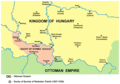
Syrmia
View on WikipediaSyrmia (Serbian: Срем, romanized: Srem; Croatian: Srijem; Pannonian Rusyn: Срим, romanized: Srim) is a region of the southern Pannonian Plain, which lies between the Danube and Sava rivers. It is divided between Serbia and Croatia. Most of the region is flat, with the exception of the low Fruška Gora mountain stretching along the Danube in its northern part.
Key Information


Etymology
[edit]The word "Syrmia" is derived from the ancient city of Sirmium (now Sremska Mitrovica).[1][2] Sirmium was a Celtic or Illyrian town founded in the third century BC.
Srem (Serbian Cyrillic: Срем) and Srijem (Сријем) are used to designate the region in Serbia and Croatia respectively.[3] Other names for the region include:
History
[edit]Prehistory
[edit]
Between 3000 BC and 2400 BC, Syrmia was at the centre of Indo-European Vučedol culture.[4]
Roman era
[edit]Sirmium was conquered by Romans in the first century BC and became the economic and political capital of Pannonia.[5] In 6 AD, there was an uprising of the indigenous peoples against Roman rule. However, ten later Roman Emperors were born in Sirmium or nearby. They included Herennius Etruscus (227–251), Hostilian (230?–251), Decius Traian (249–251), Claudius II (268–270), Quintillus (270), Aurelian (270–275), Probus (276–282), Maximianus Herculius (285–310), Constantius II (337–361), and Gratian (367–383).[citation needed]
Early Middle Ages
[edit]In the 6th century, Syrmia was part of the Byzantine province of Pannonia. During that time, Byzantine rule was challenged by Ostrogoths and Gepids. In 567, Byzantine rule was fully restored, although it later collapsed during the Siege of Sirmium by Avars and Slavs in 582. It remained under Avar rule up to c. 800, when it came under the control of the Frankish Empire. In 827, Bulgars invaded Syrmia and continued to rule after a peace treaty in 845 AD. The region was later incorporated into the Principality of Lower Pannonia, but during the 10th century it became a battleground between Hungarians, Bulgarians, and Serbs.[6]
At the beginning of the 11th century, the ruler of Syrmia was Duke Sermon, vassal of the Bulgarian emperor Samuel. There had been Bulgar resistance to Byzantine rule. This collapsed and Sermon, who refused to capitulate was captured and killed by Constantine Diogenes. A new but ultimately short lived area of governance named the Thema of Sirmium was established. It included the region of Syrmia and what is now Mačva. In 1071, Hungarians took over the region of Syrmia, but the Byzantine Empire reconquered the province after the victory over the Hungarians in the Battle of Sirmium. Byzantine rule ended in 1180, when Syrmia was taken again by the Hungarians.
Late Middle Ages
[edit]In the 13th century, the region was controlled by the Kingdom of Hungary. On 3 March 1229, the acquisition of Syrmia was confirmed by Papal bull. Pope Gregory IX wrote, "[Margaretha] soror…regis Ungarie [acquired] terram…ulterior Sirmia". In 1231, The Duke of Syrmia was Giletus. In the 1200s, the territory around Syrmia was divided into two counties: Syrmia in the east and Valkó (Vukovar) in the west.

Between 1282 and 1316, Syrmia was ruled by Stefan Dragutin of Serbia.[7][8][unreliable source?] Initially, Dragutin was a vassal of Hungary but later ruled independently. Dragutin died in 1316, and was succeeded by his son, Stefan Vladislav II (1316–1325). In 1324, Vladislav II was defeated by Stefan Uroš III Dečanski of Serbia. Lower Syrmia became the subject of dispute between the kingdoms of Serbia and Hungary.
In 1404, Sigismund, Holy Roman Emperor ceded part of Syrmia to Stefan Lazarević of Serbia.[9]
From 1459, the Hungarian kings endorsed the House of Branković and later, the Berislavići Grabarski family as the titular heads of the Serbian Despotate of which Syrmia was a part. They resided in Kupinik (modern-day Kupinovo). The local rulers included Vuk Grgurević (1471 to 1485); Đorđe Branković (1486 to 1496), Jovan Branković (1496 to 1502), Ivaniš Berislavić (1504 to 1514), and Stjepan Berislavić (1520 to 1535). In 1522, the last of the titular Serbian despots in Syrmia, Stjepan Berislavić, moved to Slavonia, ahead of invading Ottoman forces. Another important local governor was Laurence of Ilok, Duke of Syrmia (1477 to 1524), who reigned over large parts of the region from Ilok.
Early modern period
[edit]In 1521, parts of Syrmia fell to the Ottomans and by 1538, the entire region was under Ottoman control. Between 1527 and 1530, Radoslav Čelnik ruled Syrmia as an Ottoman vassal. The area of Ottoman administration in Syrmia was known as the Sanjak of Syrmia.
In 1699, the Habsburg monarchy took western Syrmia from the Ottomans as part of the Treaty of Karlowitz.[10] Until the Treaty of Passarowitz at the end of the Austro-Turkish War of 1716-18, remainder of Syrmia was part of the Habsburg Military Frontier.[11]
At the end of the Austro-Russian-Turkish War of 1735–1739, there was a migration of Albanians from the Kelmendi tribe to Syrmia, who were recorded as speaking Albanian as late as 1921.[12]
In 1745, the Syrmia County was established as part of the Habsburg Kingdom of Slavonia.[13] During the Austro-Turkish War (1788-1791), there were émigrés from Serbia who settled in Syrmia.[14]
-
 Szerém and Valkó counties, 1370
 -
 Duchy of Syrmia of Radoslav Čelnik, 1527 to 1530
 -
 Sanjak of Syrmia, 1568 to 1571
 -
 Habsburg-Ottoman frontier in Syrmia, 1699


19th century
[edit]In 1807, the Tican's Rebellion, a Syrmian peasant uprising, occurred on Ruma estate and in the village of Voganj in Ilok estate.
In 1848, most of Syrmia was part of short-lived Serbian Vojvodina, a Serb autonomous region within the Austrian Empire. By a 1849 decree of the Emperor Franz Joseph, the Voivodeship of Serbia and Banat of Temeschwar was created, comprising Northern Syrmia, including Ilok and Ruma.[15][16]
After 1860, the Syrmia County was re-established and returned to the Kingdom of Slavonia. In 1868, the Kingdom of Slavonia became part of Croatia-Slavonia in the Kingdom of Hungary.
-
 Serbian Voivodship, 1848
 -
 The County of Syrmia within Croatia-Slavonia, 1881


20th century
[edit]
On 29 October 1918, Syrmia became a part of the newly independent State of Slovenes, Croats and Serbs. On 24 November 1918, the Assembly of Syrmia proclaimed the unification of Serb-populated parts of Syrmia with the Kingdom of Serbia. However, from 1 December 1918, all of Syrmia was made a part of the Kingdom of Serbs, Croats, and Slovenes.
From 1918 to 1922, Syrmia remained within the Kingdom of Serbs, Croats, and Slovenes and from 1922 to 1929, Syrmia was a province (oblast). In 1929, after a new territorial division, Syrmia was divided between Danube Banovina and Drina Banovina, in the Kingdom of Yugoslavia and in 1931, it was divided between Danube Banovina and Sava Banovina. In 1939, the western part of Syrmia was included into the newly formed Banovina of Croatia.
In 1941, Syrmia was occupied by the World War II Axis powers and its entire territory was ceded to the Independent State of Croatia, a Nazi puppet state. The fascist Ustashe regime systematically murdered Serbs (as part of the Genocide of the Serbs), Jews (The Holocaust), Roma (The Porajmos), and some political dissidents. Nowhere in occupied Europe were more church-historical monuments destroyed than in the Independent State of Croatia. The greatest destruction took place in Srem. The Ustashe occupiers targeted parish churches and the monasteries of Fruška Gora, which housed rich treasuries and libraries. Their goal was the eradication of historical traces of the Serb presence in these areas.[17]
In August 1942, following the joint military anti-partisan operation in the Syrmia by the Ustashe and German Wehrmacht, it turned into a massacre by the Ustasha militia that left up to 7,000 Serbs dead.[18] Among those killed was the prominent painter Sava Šumanović, who was arrested along with 150 residents of Šid.[19] In 1945, with the creation of new borders, eastern Syrmia became part of the People's Republic of Serbia, while western Syrmia became part of the People's Republic of Croatia.
In 1991, Croatia declared its independence from Yugoslavia, and the Croatian War of Independence ensued shortly thereafter. The Serbs self-proclaimed in one part western Syrmia an autonomous region called the "Serbian Autonomous Region of Eastern Slavonia, Baranja and Western Syrmia". This region was one of the two Serbian autonomous regions that formed the self-declared and unrecognized Republic of Serbian Krajina. The region was ethnically cleansed of its Croat and some other non-Serb population leading to some of the most serious violation of human rights including the Lovas killings, the Tovarnik massacre, the Vukovar massacre, and other crimes. The autonomous regions lasted until 1995, when it was reintegrated in Croatia. After the war, a number of towns and municipalities in the Croatian part of Syrmia were designated Areas of Special State Concern.
Demographics
[edit]According to the 2022 census in Serbia, the territory of Serbian part of Syrmia had a population of 339,881 inhabitants, composed of 83.5% of Serbs, 2.2% of Croats, 2.1% of Slovaks, 2% of Roma, and 1.1% of Hungarians.[20][21]
According to the 2021 census in Croatia, the territory of Croatian part of Syrmia (the Vukovar-Srijem county), had a population of 143,113 inhabitants, composed of 81.6% of Croats and 13.5% of Serbs.[22]
Towns
[edit]List of towns in Syrmia with over 10,000 inhabitants:
- Serbia
- Sremska Mitrovica: 36,764
- Ruma: 27,747
- Inđija: 24,450
- Stara Pazova: 18,522
- Nova Pazova: 16,115
- Šid: 12,618
- Croatia
Geography
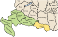
[edit]The majority of Syrmia is located in the Srem District in Serbia. A smaller area around Novi Sad is part of the South Bačka District, and another smaller area around Novi Beograd, Zemun, and Surčin belongs to the City of Belgrade. The remaining part of Syrmia is part of the Vukovar-Syrmia County in Croatia.
Syrmia's only mountain is Fruška Gora with its highest peak, Crveni Čot, at 539 m.
Borders
[edit]

The present Serbia-Croatian border in Syrmia was drawn in 1945 by the so-called Đilas Commission. It draw the administrative border line between the Yugoslav constituent republics of Croatia and Serbia. Milovan Đilas, a Montenegrin and then a confidant of Josip Broz Tito, drew the border according to demographic criteria, which explains why the town of Ilok on the Danube, with an ethnic Croat majority, lies east of Šid in Serbia, with an ethnic Serb majority. The border drawn in 1945 was very similar to the 1931-1939 border between the Danube Banovina and the Sava Banovina within the Kingdom of Yugoslavia.
Bordering regions
[edit]- Bačka to the north
- Banat to the east
- Šumadija the south-east
- Mačva to the south
- Semberija to the south-west
- Slavonia to the west. The border between Syrmia and Slavonia is unclear. It runs approximately along a line through Vukovar, Vinkovci, and Županja or it follows the Bosut, Barica and Vuka rivers.
Cities and municipalities
[edit]Cities and municipalities in Serbian Syrmia:
The Syrmian villages of Neštin and Vizić are part of the municipality of Bačka Palanka, the main part of which is in Bačka. Several settlements that are part of the City of Sremska Mitrovica are located in Syrmia in Mačva.
Cities and municipalities in Croatian Syrmia:
See also
[edit]References
[edit]- ^ Stewart Traill, Thomas (1860). The Encyclopaedia Britannica: Or, Dictionary of Arts, Sciences, and General Literature, Volume 20. Little, Brown, & Company. p. 327.
- ^ Protić, Marijana; Smičiklas, Nemanja; Bulajić, Vladimir (2017). "Conservation, Restoration, and Presentation of Two Mosaics from Room 16, Imperial Palace, Sirmium". In Teutonico, Jeanne Marie; Friedman, Leslie; Abed, Aïcha Ben (eds.). The Conservation and Presentation of Mosaics: At What Cost?: Proceedings of the 12th Conference of the International Committee for the Conservation of Mosaics, Sardinia, October 27–31, 2014. Getty Publications. p. 387. ISBN 9781606065334.
- ^ Gecser, Ottó; Laszlovszky, József; Nagy, Balázs; Sebők, Marcell; Szende, Katalin, eds. (2010). Promoting the Saints: Cults and Their Contexts from Late Antiquity until the Early Modern Period. Central European University Press. pp. 84–85. ISBN 9789633863923.
- ^ Syrmia, vjesnik.hr; accessed 13 April 2015.
- ^ Mennen, Inge (2011). Power and Status in the Roman Empire, AD 193-284. BRILL. p. 40. ISBN 9789004203594.
- ^ Ćirković 2004.
- ^ Veselinović R. Istorija Srpske pravoslavne crkve sa narodnom istorijom I Belgrade, 1969. p. 18
- ^ Grujić R. Pravoslavna Srpska crkva, Kragujevac, 1989, p22.
- ^ Stepanović, Predrag (1986). A Taxonomic Description of the Dialects of Serbs and Croats in Hungary: The Štokavian Dialect. Akad. K. p. 22. ISBN 9783412074845.
- ^ Stoye J. Marsigli's Europe, 1680-1730 Yale University Press, 1994 p185 ISBN 0300055420, 9780300055429 Accessed at Google Books 3 August 2016.
- ^ Ingrao, Samardžić & Pešalj 2011, p. 193.
- ^ Karl Gottlieb von Windisch: On the Kelmendi in Syrmia
- ^ "Establishment and Organisation of Counties in Eastern Croatia from 1745-1848". Glasnik arhiva Slavonije i Baranje. 6: 34. 2001.
The empress Maria Theresa renewed in 1745 three Slavonian counties: the Virovitica county with the centre in Osijek, the Požega county with the centre in Požega and the Syrmia county with the centre in Vukovar.
- ^ Ćirković 2004, p. 160.
- ^ Petsinis, Vassilis (2019). National Identity in Serbia: The Vojvodina and a Multi-Ethnic Community in the Balkans. Bloomsbury Publishing. p. 37. ISBN 9781788317085.
- ^ Ivanišević, Alojz (1984). Kroatische Politik der Wiener Zentralstellen von 1849 bis 1852 (in German). VWGÖ. p. 48. ISBN 9783853695784.
..die Einverleibung der seit dem 18.11.1849 zur [Serbisch] Vojvodschaft gehörenden syrmischen Bezirke Ruma und Ilok
- ^ Živković, Mirjana; Todović, Milenko (1995). Krađa kulturnog i nacionalnog blaga Jugoslavije. Beograd: Vojska, Dečje novine. p. 23.
- ^ Korb, Alexander (2010c). "Integrated Warfare? The Germans and the Ustaša Massacres: Syrmia 1942". In Shepherd, Ben (ed.). War in a Twilight World: Partisan and Anti-Partisan Warfare in Eastern Europe, 1939–1945. Palgrave Macmillan. ISBN 978-0-230-29048-8.
- ^ Greif, Gideon (2018). Jasenovac - Auschwitz of the Balkans. Knjiga komerc. p. 437. ISBN 9789655727272.
- ^ "Archived copy" (PDF). Archived from the original (PDF) on 2014-08-11. Retrieved 2015-06-02.
{{cite web}}: CS1 maint: archived copy as title (link) - ^ http://pop-stat.mashke.org/serbia-ethnic-loc2022.htm
- ^ https://dzs.gov.hr/u-fokusu/popis-2021/88
Sources
[edit]- Ćirković, Sima (2004). The Serbs. Malden: Blackwell Publishing. ISBN 9781405142915.
- Engel, Pál (2001). The Realm of St. Stephen: A History of Medieval Hungary, 895-1526. London & New York: I.B.Tauris. ISBN 9781850439776.
- Fine, John V. A. Jr. (1991) [1983]. The Early Medieval Balkans: A Critical Survey from the Sixth to the Late Twelfth Century. Ann Arbor: University of Michigan Press. ISBN 0-472-08149-7.
- Fine, John V. A. Jr. (1994) [1987]. The Late Medieval Balkans: A Critical Survey from the Late Twelfth Century to the Ottoman Conquest. Ann Arbor, Michigan: University of Michigan Press. ISBN 978-0-472-10079-8. OCLC 749133662.
- Fine, John Van Antwerp Jr. (2005). When Ethnicity Did Not Matter in the Balkans: A Study of Identity in Pre-Nationalist Croatia, Dalmatia, and Slavonia in the Medieval and Early-Modern Periods. Ann Arbor, Michigan: University of Michigan Press. ISBN 0472025600.
- Ingrao, Charles; Samardžić, Nikola; Pešalj, Jovan, eds. (2011). The Peace of Passarowitz, 1718. West Lafayette: Purdue University Press.
- Коматина, Ивана; Коматина, Предраг (2018). "Византијски и угарски Срем од X до XIII века" [The Byzantine and Hungarian Syrmia in the 10th-13th Centuries]. Зборник радова Византолошког института (in Serbian). 55: 141–164.
- Komatina, Predrag (2010). "The Slavs of the mid-Danube basin and the Bulgarian expansion in the first half of the 9th century" (PDF). Зборник радова Византолошког института. 47: 55–82.
- Petar Milošević (1981). Srem u prošlosti. Novinsko-izdavačka radna organizacija "Sremske novine.".
- Žarko Atanacković (1968). Srem u narodnooslobodilačkom ratu i socijalističkoj revoluciji. Šimanovci, Mesna zajednica-Mesni odbor SUB NOR-a.
- Đorđe Cvejić; Jovan Babović; Miodrag Živković (1982). Srem u samoupravnoj socijalističkoj Jugoslaviji 1945-1981. NIO Poslovna politika.
- Slavko Gavrilović (1979). Srem od kraja XVII do sredine XVIII veka. Filozofski fakultet u Novom Sadu, Institut za istoriju.
- Mihailo Dinić. Sredjnevekovni Srem.
- Миодраг Матицки (2007). Срем кроз векове: слојеви култура Фрушке горе и Срема : зборник радова. Вукова Задужбина. ISBN 978-86-902961-5-6.
- Слободан Ћурчић (2012). Атлас насеља Војводине: Срем. Матица српска. ISBN 978-86-7946-108-7.
- Pálosfalvi, Tamás (2018). From Nicopolis to Mohács: A History of Ottoman-Hungarian Warfare, 1389-1526. Leiden: BRILL. ISBN 9789004375659.
- Pešalj, Jovan (2010). "Early 18th-Century Peacekeeping: How Habsburgs and Ottomans Resolved Several Border Disputes after Karlowitz". Empires and Peninsulas: Southeastern Europe between Karlowitz and the Peace of Adrianople, 1699–1829. Berlin: LIT Verlag. pp. 29–42. ISBN 9783643106117.
- Radojević, Mira (1992). "Sporazum Cvetković-Maček i pitanje razgraničenja u Sremu" (PDF). Istorija 20. Veka: Časopis Instituta za savremenu istoriju. 10 (1–2): 61–72.
- Radojević, Mira (1996). "Srpsko-hrvatski spor oko Vojvodine 1918-1941" (PDF). Istorija 20. Veka: Časopis Instituta za savremenu istoriju. 14 (2): 39–73.
External links
[edit] Media related to Syrmia at Wikimedia Commons

| Principal historical regions |  | ||||||||
|---|---|---|---|---|---|---|---|---|---|
| Smaller regions |
| ||||||||
 | ||
| International | |
|---|---|
| National | |
| Other | |
Syrmia
View on GrokipediaEtymology
Name derivation and historical usage
The name Syrmia derives from the ancient city of Sirmium, a major Roman settlement established on the site of earlier Celtic or Illyrian foundations dating to the 3rd century BCE, now identified with Sremska Mitrovica in Serbia. The term Sirmium itself likely stems from Indo-European linguistic roots connoting "flow," "flowing water," or "wetland," apt for the city's location amid the flood-prone confluence of the Sava and Danube rivers.[5] Roman administrators extended the name Syrmia to the broader province encompassing the interfluvial territory between the Sava and Danube, formalized as Valeria or Pannonia Secunda by the 4th century CE, with Sirmium serving as its administrative and imperial hub—site of eleven Roman emperors' proclamations and a temporary capital under emperors like Aurelian (r. 270–275 CE) and Galerius (r. 305–311 CE).[6] Post-Roman, the designation persisted in Byzantine and Slavic contexts, evolving into medieval Hungarian Szerém for the county established around 1200 CE, which included much of the region until the Ottoman conquest in 1526.[2] In modern usage, the name manifests as Srem (Serbian Cyrillic: Срем) in Serbia, denoting the autonomous province's eastern district, and Srijem in Croatia, applied to the Vukovar-Srijem County formed in 1991 amid the Yugoslav breakup. Earlier folk etymologies linking Sirmium to the Thracian-Triballian king Syrmus (4th century BCE) represent conflation rather than direct derivation, as the hydrological root predates such associations.[7]Geography
Physical geography and terrain
Syrmia lies in the southern part of the Pannonian Plain, consisting primarily of flat, low-lying alluvial terrains between the Danube River to the north and the Sava River to the south.[8] Elevations across most of the region remain below 200 meters above sea level, forming expansive fertile plains conducive to agriculture.[1] The landscape features riverine floodplains, meanders, and occasional levees along the bounding rivers, with the Danube contributing to broader alluvial deposits in the northern Serbian portion.[8] The sole significant topographic prominence is the Fruška Gora mountain range, located in the northern Serbian section along the Danube, which forms an elongated, low horst with maximum elevations reaching 539 meters at Crni Vrh.[9] This range, characterized by rolling hills, deep valleys, and dense oak and beech forests, contrasts with the surrounding lowlands and serves as a hydrological divide, with streams draining northward to the Danube and southward toward the Sava.[9] In the Croatian portion, the terrain remains uniformly level, lacking comparable elevations. Soils in Syrmia are predominantly chernozem and loess-based, derived from Quaternary deposits, which underpin the region's historical role as a granary through high fertility and good drainage.[1] These pedological features, combined with the flat relief, facilitate widespread cultivation of grains, fruits, and vineyards, though occasional saline patches occur near river margins.[10]
Borders and administrative divisions
Syrmia occupies the lowland territory between the Danube River to the north and the Sava River to the south, within the southern Pannonian Plain. Its western extent reaches approximately the confluence of the Sava and Drina rivers, while the eastern boundary lies near Belgrade. This geographical definition has persisted historically, though modern political divisions bisect the region along the Croatia-Serbia international border, which follows the Danube in northern sections and traverses inland areas.[3] In contemporary administration, Syrmia's western portion falls within Croatia's Vukovar-Srijem County, the easternmost county of the country, spanning 2,448 km² between the Danube and Sava rivers. The county borders Serbia to the east, Bosnia and Herzegovina across the Sava to the south, and other Croatian counties including Brod-Posavina and Požega-Slavonia to the west and southwest. It encompasses municipalities such as Vukovar, Vinkovci, Županja, and Ilok, integrating western Syrmia with adjacent eastern Slavonian territories.[11][12] The eastern segment of Syrmia lies in Serbia's autonomous province of Vojvodina, primarily comprising the Srem District (Sremski okrug). This district covers core Syrmian lands north of the Sava, bordering Croatia to the west along the Danube and Sava rivers, the Mačva District to the south across the Sava, and other Vojvodina districts including South Bačka and Srem's internal divisions to the north and east. It consists of seven municipalities: the City of Sremska Mitrovica, Inđija, Irig, Pećinci, Ruma, Stara Pazova, and Šid.[13]| Municipality | Status | Key Notes |
|---|---|---|
| Sremska Mitrovica | City | Administrative center of the district |
| Inđija | Municipality | Includes industrial and agricultural areas |
| Irig | Municipality | Features Fruška Gora national park sections |
| Pećinci | Municipality | Borders Belgrade vicinity |
| Ruma | Municipality | Historical town with diverse population |
| Stara Pazova | Municipality | Proximity to Belgrade airport |
| Šid | Municipality | Westernmost, near Croatian border |
Major cities and settlements
Syrmia's major cities and settlements are split between Serbia's Srem District and Croatia's Vukovar-Srijem County, reflecting the region's post-Yugoslav division along ethnic and administrative lines. In the Serbian section, Sremska Mitrovica serves as the principal urban center, with a city population of 83,644 recorded in the 2022 census, encompassing the ancient Roman site of Sirmium.[14] Other key municipalities include Stara Pazova (67,576 inhabitants), Ruma (60,993), Inđija (47,422), and Šid (34,188), which together form hubs for agriculture, industry, and transport along the Danube and Sava rivers.[14] Smaller settlements like Sremski Karlovci, known for its Orthodox seminary and wine production, and Irig, add cultural and viticultural significance to the area.[15] In Croatia's western Syrmia, Vinkovci emerges as the largest city with 30,842 residents per the 2021 census, noted for its prehistoric Vučedol culture artifacts and annual folklore festival.[16] Vukovar, with 23,175 inhabitants, holds strategic port status on the Danube despite wartime destruction in 1991, while Županja (9,150) and Ilok (5,051) support river trade and viticulture in the eastern county extremities.[17] The county's total population stood at 143,113 in 2021, down from prior decades due to emigration and conflict aftermath. These settlements underscore Syrmia's mixed Serb-Croat demographics and economic reliance on fertile plains for grain and fruit production.[1]| City/Municipality | Country | Population | Census Year |
|---|---|---|---|
| Sremska Mitrovica | Serbia | 83,644 | 2022[14] |
| Stara Pazova | Serbia | 67,576 | 2022[14] |
| Ruma | Serbia | 60,993 | 2022[14] |
| Vinkovci | Croatia | 30,842 | 2021[16] |
| Vukovar | Croatia | 23,175 | 2021[18] |
History
Prehistory and ancient settlements
The region of Syrmia exhibits evidence of Neolithic settlements dating to the 6th and 5th millennia BC, primarily associated with the Starčevo culture and influenced by local geo-pedological conditions such as fertile loess soils and favorable climate, which supported agricultural communities encircled by moats in eastern Croatia and western Syrmia.[19] These early farming villages, characterized by pit-houses and pottery, reflect a transition to sedentary life amid the Pannonian Plain's riverine environment between the Sava and Danube.[20] During the Chalcolithic period, the Vučedol culture emerged around 3000–2500 BC, centered on the right bank of the Danube in Syrmia and eastern Slavonia, with key sites like Vučedol near Vukovar yielding distinctive ceramics, including the iconic Vučedol Dove vessel possibly bearing proto-writing.[21] This Eneolithic society, marked by copper metallurgy, fortified tell settlements, and Indo-European influences, represented a peak in regional cultural complexity before declining around 2200 BC.[22] Bronze Age occupation in Syrmia, spanning roughly 2200–800 BC, included diverse sites documented through stratigraphy at Gomolava near Sremska Mitrovica, which provides a sequence from early to late phases with urn burials and bronze artifacts aligning with broader Carpathian Basin traditions.[23] The Late Bronze Age saw influences from the Urnfield culture in the Sava valley, featuring cremation practices and fortified hill settlements from the 13th to 9th centuries BC, indicative of increased mobility and trade.[24] In the Iron Age (ca. 800–1st century BC), Syrmia hosted settlements of Pannonian tribes such as the Amantini alongside Celtic groups arriving in the late 4th to early 3rd centuries BC, with Sirmium emerging as a proto-urban center inhabited by Celts prior to Roman conquest.[25] Archaeological evidence includes Late Iron Age graves with weapons and jewelry, suggesting hierarchical societies amid Celtic expansions into the Pannonian Plain.[26] These pre-Roman communities exploited the region's fertility for agriculture and controlled riverine routes, though specific Illyrian tribal presence remains less attested compared to neighboring areas.[27]Roman and late antique periods
Syrmia was incorporated into the Roman Empire as part of the province of Illyricum following the campaigns against the Pannonian tribes between 35 BC and 9 BC, with full control secured after the suppression of the Great Illyrian Revolt in 9 AD.[28] The region, strategically positioned between the Sava and Danube rivers, served as a frontier zone, hosting legionary camps and fortifications to defend against barbarian incursions from the north. Sirmium, located at modern Sremska Mitrovica, emerged as the administrative and economic center of Lower Pannonia after provincial reorganizations under Trajan around 106 AD, benefiting from its position on key trade routes linking the Adriatic to the Black Sea. By the 3rd century AD, Sirmium had grown into a major urban center, with evidence of extensive infrastructure including amphitheaters, baths, and aqueducts supporting a population estimated at over 100,000.[29] The city produced or hosted several emperors, including Probus (r. 276–282 AD), born locally, and Maximian (r. 286–308 AD), who elevated its status through imperial patronage.[25] Military significance intensified during the Crisis of the Third Century, as Sirmium became a base for campaigns against Goths and Sarmatians, with emperors like Aurelian (r. 270–275 AD) and Probus using it as a staging ground.[5] In the late 3rd century, Diocletian's Tetrarchy (293–313 AD) designated Sirmium as one of four imperial capitals, serving as the residence for Galerius, the Caesar of the East, who constructed a grand palace complex there. This period marked the peak of Sirmium's influence, as it hosted the Praetorian Prefecture of Illyricum after 318 AD, overseeing dioceses across the Balkans. Emperors such as Constantine I, Licinius, and later Theodosius I (proclaimed in 379 AD) resided or issued edicts from the city, underscoring its role in administrative reforms and Christianization efforts amid theological councils addressing Arianism.[25] The late antique period saw Syrmia's decline begin with barbarian pressures; Hunnic forces under Attila sacked Sirmium in 441 AD, depopulating the city and disrupting regional trade.[25] Subsequent control oscillated among Gepids, Ostrogoths, and Lombards until Byzantine reconquest in 567–582 AD, after which Avar invasions in 582 AD led to Sirmium's abandonment as a major center, shifting power dynamics in the region toward emerging Slavic settlements.[5] Archaeological remains, including the imperial palace and hippodrome, attest to the engineering prowess but also the vulnerability of Roman frontier defenses in Syrmia.[29]Early and High Middle Ages
In the aftermath of late antiquity, Syrmia underwent profound transformations due to barbarian migrations and invasions. Following Ostrogothic control in the early 6th century, the Pannonian Avars, allied with early Slavic groups, penetrated the region, besieging and capturing the former Roman capital Sirmium in 582 after a prolonged effort against Byzantine defenses; the city was subsequently razed, marking the effective end of organized Roman administration there.[30][31] Slavic tribes, initially arriving as auxiliaries to the Avars, established permanent settlements across Syrmia from the mid-6th century onward, supplanting residual Romanized populations amid the depopulation caused by warfare and economic collapse; these Slavs, including proto-Serbian and Croatian groups, subsisted under Avar suzerainty until the khaganate's disintegration in the late 8th century following Frankish military campaigns under Charlemagne.[30][31] The region's sparse archaeological record from this era reflects fortified hilltop sites and early Slavic pottery, indicative of agrarian communities vulnerable to overlords rather than urban revival.[3] By the 9th century, Syrmia transitioned to Bulgarian overlordship as the First Bulgarian Empire expanded westward under khans like Krum and tsars like Simeon I, incorporating local Slavic principalities into a tributary system that facilitated cultural and Orthodox Christian influences.[31] This arrangement persisted into the early 11th century, though fragmented by internal Bulgarian strife and Byzantine counteroffensives; after the empire's defeat by Byzantium in 1018, Hungarian forces under King Stephen I exploited the power vacuum, annexing Syrmia by the 1020s through conquest and alliances with local Slavs, integrating it into the emerging Kingdom of Hungary's southern frontier.[31][32] During the High Middle Ages, Syrmia functioned as a peripheral county (comitatus) within Hungary, administered from centers like Ilok and Vukovar, with royal grants to magnates fostering feudal estates amid ongoing border skirmishes with Byzantium and emerging Serbian principalities.[33] The 12th-13th centuries saw economic stabilization through riverine trade along the Sava and Danube, Slavic customary law blended with Hungarian institutions, and ecclesiastical oversight via dioceses like Kalocsa, though Mongol invasions in 1241-1242 devastated settlements, prompting reconstruction under Béla IV that emphasized fortified monasteries and border defenses.[32][33] Trans-Syrmia (southern extensions beyond the Sava) was periodically enfeoffed to loyalists, such as Rostislav Mihailovich (r. ca. 1247-1254), who held ducal titles over Macsó and adjacent territories, reflecting Hungary's strategy of decentralized control in ethnically Slavic borderlands.[33]Late Middle Ages and Ottoman conquest
During the late Middle Ages, Syrmia constituted the medieval Syrmia County, an administrative division of the Kingdom of Hungary established by the 13th century and persisting until the Ottoman incursions.[34] The region experienced influences from neighboring powers, including the Serbian Despotate, which expanded into Hungarian borderlands amid Ottoman pressures in the 14th and 15th centuries.[35] From 1404 onward, Hungarian King Sigismund granted governance of portions of Syrmia, along with Bačka and Banat, to Serbian Despot Stefan Lazarević as a vassal arrangement to bolster defenses against Ottoman expansion.[36] This pattern continued under subsequent despots, including Đurađ Branković and his descendants, who administered exiled Serbian territories in Syrmia under Hungarian overlordship following the fall of Smederevo in 1459, maintaining a semi-autonomous status until the mid-16th century.[37] Pavle Bakić emerged as the final recognized despot, commanding Serbian forces allied with Hungary and holding influence in Syrmia until his death at the Battle of Gorjani on October 9, 1537.[38] The Ottoman conquest of Syrmia commenced in earnest after the decisive Battle of Mohács on August 29, 1526, where Hungarian forces under King Louis II suffered catastrophic defeat against Sultan Suleiman the Magnificent, fragmenting Hungarian authority and exposing the Pannonian basin to direct Ottoman advance.[39] In the ensuing power vacuum, Serbian commander Radoslav Čelnik, previously aligned with the short-lived "Emperor" Jovan Nenad, relocated remnants of his forces to Syrmia in 1527, establishing a nominal Duchy of Syrmia as an Ottoman vassal until approximately 1530.[40] Ottoman administrative structures, including the Sanjak of Syrmia, solidified control over the region by the late 1520s, with tahrir defters documenting fiscal organization shortly thereafter, marking the transition to full incorporation into the empire's Balkan provinces.[41]Habsburg and early modern era
The Habsburg Monarchy reconquered Syrmia from the Ottoman Empire during the Great Turkish War (1683–1699), with decisive advances following the Battle of Zenta on September 11, 1697, led by Prince Eugene of Savoy.[42] The Treaty of Karlowitz, signed on January 26, 1699, formally ceded the region to Habsburg control, marking the end of Ottoman dominance in much of the area north of the Sava River.[42] This transfer integrated Syrmia into the Habsburg administrative framework, initially as part of the newly formed Kingdom of Slavonia, which encompassed reconquered territories east of the Sava.[43] Amid the upheavals of the war, Serbian Patriarch Arsenije III Čarnojević led the First Great Serbian Migration in 1690–1691, with approximately 30,000–40,000 Orthodox Serb families fleeing Ottoman retribution and resettling in Habsburg lands, including significant numbers in Syrmia.[44] These settlers, granted privileges such as religious autonomy and land for military service, bolstered the region's defense capabilities.[45] Syrmia was incorporated into the Habsburg Military Frontier system, particularly the Slavonian Military Frontier established around 1745, where local inhabitants formed grenzer regiments to maintain the border against Ottoman threats.[46] This militarized zone extended to southern portions of Syrmia, emphasizing fortified settlements and systematic colonization to secure the frontier.[47] In the mid-18th century, administrative consolidation advanced with the establishment of Syrmia County in 1745 within the Kingdom of Slavonia, facilitating civil governance alongside military structures.[48] The diocese of Syrmia, under Habsburg rule by the late 17th century, managed ecclesiastical affairs amid economic challenges, including post-war recovery and plague outbreaks.[48] Habsburg policies promoted settlement by diverse groups, including Danube Swabians, to repopulate depopulated areas, fostering agricultural development while prioritizing strategic defense.[42] These measures stabilized the region through the 18th century, though intermittent conflicts, such as the Austro-Turkish War of 1788–1791, tested the frontier's resilience.[49]19th century nationalism and reforms
The 1848 revolutions in the Habsburg Monarchy ignited Serbian nationalist aspirations in Syrmia, then part of the Kingdom of Slavonia. On May 13, 1848, the Serbian National Assembly convened in Sremski Karlovci, proclaiming the formation of the Serbian Voivodeship, which united Syrmia, Bačka, Banat, and Baranja under Serbian administration as an autonomous entity loyal to the Habsburg emperor.[50] This declaration, led by figures such as Josif Rajačić, who was elected Serbian patriarch, responded to Hungarian revolutionary demands for centralization under Lajos Kossuth, which threatened Slavic autonomies. Serbian militias, bolstered by volunteers from the Principality of Serbia, fought alongside imperial forces against Hungarian troops, securing temporary gains in the region.[51] Following the Habsburg victory over Hungary in 1849, Emperor Franz Joseph established the Voivodeship of Serbia and the Banat of Temeswar as a distinct crownland, incorporating Syrmia and granting it limited self-governance with a Serbian diet and administration until 1860.[50] This period marked initial reforms in local governance, education, and Orthodox ecclesiastical autonomy, fostering Serbian cultural institutions amid ongoing ethnic tensions. However, after the crownland's dissolution in 1860, Syrmia reverted to Hungarian oversight, heightening Serb discontent as Hungarianization policies intensified. The Austro-Hungarian Compromise of 1867 and the subsequent Croatian-Hungarian Settlement (Nagodba) of 1868 profoundly altered Syrmia's status. Under the Nagodba, the Kingdom of Slavonia, including Syrmia, merged with Croatia to form the Kingdom of Croatia-Slavonia within the Hungarian half of the Dual Monarchy, affording Croats a degree of autonomy via the Sabor diet, Croatian-language administration, and control over internal affairs like education and judiciary.[52] Syrmia was reorganized as one of eight counties (županates), with Vukovar as its seat, implementing reforms such as standardized county governance and infrastructure development, though Serb communities, concentrated in eastern Syrmia, resisted perceived Croat dominance and advocated for cultural preservation through the Orthodox Church.[44] These changes reflected broader Habsburg efforts to balance nationalist pressures, yet sowed seeds for inter-ethnic rivalries persisting into the 20th century.World War I, interwar period, and Kingdom of Yugoslavia
During World War I, Syrmia formed part of the Kingdom of Croatia-Slavonia within Austria-Hungary, serving primarily as a strategic hinterland rather than a primary theater of combat, though it hosted military installations and experienced economic strains from wartime mobilization. The region's Austro-Hungarian forces contributed to eastern fronts, but internal disintegration accelerated after the Allied Vardar Offensive on September 15, 1918, where Serbian troops achieved a decisive breakthrough against Bulgarian lines, advancing over 600 kilometers in 45 days to reclaim occupied Serbian territories. By late October and early November 1918, elements of the Serbian Army crossed the Danube and Sava rivers into Syrmia, encountering minimal resistance from collapsing Austro-Hungarian units, and secured key towns such as Vukovar and Sremska Mitrovica by mid-November, effectively liberating the area amid the empire's dissolution.[53][54] Following the Armistice of November 11, 1918, Syrmia was incorporated into the newly proclaimed Kingdom of Serbs, Croats, and Slovenes on December 1, 1918, uniting former Habsburg South Slavic lands with Serbia under a centralized monarchy led by King Peter I and Regent Alexander. Administratively, the region retained its pre-war county structure as Syrmia County until 1922, when it was reorganized into Syrmia Oblast centered at Vukovar, reflecting efforts to consolidate oblasts amid post-war instability. The interwar period saw ongoing centralist policies from Belgrade, including the 1921 Vidovdan Constitution, which emphasized unitary statehood over federalism, exacerbating Serb-Croat tensions; Croatian Peasant Party leaders like Stjepan Radić criticized the system for marginalizing non-Serb regions, while Syrmia's mixed loyalties fueled local political divisions. In 1929, King Alexander's dictatorship renamed the state the Kingdom of Yugoslavia and divided it into nine banovinas, placing eastern Syrmia within the Danube Banovina (encompassing Vojvodina) and western portions across adjacent units, prioritizing strategic over ethnic boundaries.[55] Syrmia's interwar demographics reflected its ethnic mosaic, with the 1921 census indicating Serbs forming majorities in eastern settlements (often exceeding 50% in areas like around Sremska Mitrovica), Croats predominant in the west, and substantial Danube Swabian German (around 20-30% regionally) and Hungarian minorities, shaped by Habsburg-era colonization. Agrarian reforms enacted from 1919 redistributed large estates—totaling over 2 million hectares nationwide by 1941—favoring landless peasants and veterans, including Serb settlers from southern Serbia into Syrmia's fertile plains, which boosted agricultural output but intensified ethnic frictions as German and Hungarian landowners faced expropriation. German communities formed cultural associations like the Swabian-German Cultural Union in 1920, advocating minority rights amid rising nationalism, while economic recovery focused on grain production and viticulture, though rural overpopulation and uneven modernization persisted until the 1939 Cvetković-Maček agreement granted Croatian autonomists the Banovina of Croatia, incorporating western Syrmia to mitigate separatist pressures.[56]World War II and immediate aftermath
Following the Axis invasion of the Kingdom of Yugoslavia on April 6, 1941, Syrmia was incorporated into the Independent State of Croatia (NDH), a puppet regime established by the Ustaše movement on April 10, 1941, under Nazi German and Fascist Italian oversight.[57] The NDH encompassed Syrmia alongside inner Croatia, Slavonia, and Bosnia-Herzegovina, where the Ustaše pursued policies of ethnic homogenization targeting Serbs, Jews, and Roma. In Syrmia, these efforts included mass killings, such as the August 1942 joint Ustaše-Wehrmacht operation that resulted in up to 7,000 Serb deaths through massacres during anti-partisan sweeps.[58] Yugoslav Partisan forces, led by Josip Broz Tito, conducted guerrilla operations against NDH and Axis troops throughout the occupation, gaining strength amid widespread Serb resistance to Ustaše rule.[59] As Soviet forces advanced westward in late 1944, the region became the site of the Syrmian Front, an Axis defensive line established after Partisans and the Red Army crossed the Sava River on October 22, 1944.[60] The front pitted Yugoslav Partisan units—reorganized into the Yugoslav Army—alongside limited Soviet and Bulgarian support against German Army Groups E and F, featuring intense positional warfare with repeated offensives and counterattacks, including the German "Wintergewitter" operation launched on January 17, 1945. Yugoslav forces suffered at least 13,000 fatalities over the six-month campaign, one of the bloodiest in the Yugoslav theater, marked by trench fighting and high attrition.[60] The front collapsed with the final Partisan offensive beginning April 12, 1945, capturing key towns like Vukovar and Vinkovci, though German units largely evaded encirclement and withdrew northward.[60] In the immediate post-war period, liberated Syrmia was integrated into the emerging Socialist Federal Republic of Yugoslavia (SFRY), with republican borders delineated by the Anti-Fascist Council for the National Liberation of Yugoslavia (AVNOJ) decisions finalized after hostilities ended in May 1945. The region was divided, with eastern Syrmia (Srem) assigned to the Socialist Autonomous Province of Vojvodina within Serbia, and western Syrmia (Srijem) to Croatia, reflecting post-war administrative priorities over pre-war ethnic distributions. Retributive measures followed, including the internment and expulsion of ethnic Germans (Danube Swabians), who had numbered significantly in Syrmia and often collaborated with Axis forces, leading to thousands of deaths from forced labor and deportation.[61] This division and demographic shifts set the framework for Syrmia's role in the socialist era, amid the consolidation of communist authority.[61]Socialist Federal Republic of Yugoslavia era
After World War II, in November 1944, the region of Syrmia was divided between the Socialist Republic of Serbia and the Socialist Republic of Croatia, with the eastern portion (Srem) incorporated into the Autonomous Province of Vojvodina and the western (Srijem) assigned to Croatia, reflecting wartime partisan administrative decisions.[62] Land reform from 1945 to 1947 redistributed approximately 2.5 million hectares nationwide, including in Syrmia, breaking up large estates and providing plots to landless peasants, though much of the region's fertile alluvial soils along the Danube and Sava rivers remained geared toward collective farming.[63] Collectivization of agriculture began in earnest in 1949, forming cooperatives that by 1953 encompassed over 70% of arable land in Vojvodina, including Srem's grain, fruit, and viticulture sectors; however, peasant resistance and the 1953 shift to worker self-management led to widespread decollectivization, with private farming reviving as the dominant model by the late 1950s. Industrial growth focused on agro-processing and manufacturing, such as food plants in Ruma and metalworks in Sremska Mitrovica, supported by federal five-year plans emphasizing self-managed enterprises. In western Syrmia, Vukovar developed as a major industrial node, with the Borovo combine producing footwear and rubber goods on a scale that made it one of Yugoslavia's top exporters by the 1970s.[64] The 1974 Yugoslav Constitution significantly expanded Vojvodina's autonomy, granting the province veto rights over Serbian republican decisions affecting it and separate representation in federal bodies, which bolstered local governance in Srem while reinforcing multiethnic policies under the slogan of "brotherhood and unity."[65] Environmental protection advanced with the 1960 declaration of Fruška Gora as Serbia's first national park, safeguarding 25,000 hectares of oak forests, endemic species, and historic monasteries amid rising tourism and recreation initiatives. Economic strains post-Tito's 1980 death, including hyperinflation exceeding 2,500% by 1989 and foreign debt surpassing $20 billion, increasingly impacted the region's agricultural exports and industrial output, setting the stage for later instability.[66]Dissolution of Yugoslavia and 1990s conflicts
The dissolution of the Socialist Federal Republic of Yugoslavia began in earnest in 1991, with Slovenia and Croatia declaring independence on June 25, triggering armed conflicts as the Yugoslav People's Army (JNA) intervened to preserve federal unity. In Syrmia, the region spanning modern-day eastern Croatia and northern Serbia, ethnic tensions between Serbs and Croats escalated rapidly, particularly in the Croatian portion known as Srijem. Western Syrmia, encompassing areas like Vukovar-Srijem County, saw the formation of the self-proclaimed Serbian Autonomous Oblast (SAO) of Eastern Slavonia, Baranja, and Western Syrmia on the same day as Croatia's independence declaration, as local Serbs sought alignment with Serbia amid fears of marginalization. Armed clashes erupted in early May 1991 in villages such as Borovo Selo, marking the onset of hostilities in the region.[67][68] The most intense fighting occurred during the Siege of Vukovar from August 25 to November 18, 1991, where JNA forces, supported by local Serb paramilitaries and units from Serbia, bombarded the city with thousands of shells daily, leading to its fall after 87 days. Croatian defenders, numbering around 2,000 soldiers and civilians, suffered heavy losses, with approximately 1,800 killed and the city left in ruins; following the capitulation, Serb forces massacred over 200 prisoners at the Vukovar hospital and forcibly displaced at least 20,000 non-Serbs. Eastern Slavonia, including western Syrmia, remained under de facto Serb control as part of the Republic of Serbian Krajina (RSK) until 1995, during which period human rights abuses, including arbitrary detentions and expulsions of Croats, were documented by international observers. In contrast, the Serbian portion of Syrmia (Srem) in Vojvodina experienced no major combat, remaining under the control of the Federal Republic of Yugoslavia (FRY), though it absorbed refugees fleeing Croatian offensives elsewhere.[68][67] The 1995 Croatian Operation Storm accelerated the RSK's collapse, prompting the exodus of over 150,000 Serbs from Croatia, including from western Syrmia, to Serbia and Bosnia; reports indicate Croatian forces committed reprisal killings and looting in recaptured areas, contributing to the demographic shift. Peaceful reintegration of eastern Slavonia, Baranja, and western Syrmia followed the Erdut Agreement signed on November 12, 1995, between Croatian officials and local Serb leaders, establishing the United Nations Transitional Administration for Eastern Slavonia, Baranja and Western Sirmium (UNTAES). UNTAES oversaw demilitarization and the return of Croatian authority, completing the process by January 15, 1998, with minimal violence, though lingering mistrust and property disputes persisted. These events profoundly altered Syrmia's ethnic composition, with Serbs comprising about 12% of Vukovar-Srijem County's population by the 2001 census, down from pre-war levels.[67]Post-2000 developments and integration
In the Serbian portion of Syrmia, comprising the Srem District within the autonomous province of Vojvodina, the overthrow of Slobodan Milošević's regime in October 2000 initiated democratic reforms that restored elements of Vojvodina's pre-1989 autonomy, including greater legislative and executive powers formalized in the province's 2009 Statute.[69] These changes addressed local grievances over centralization, fostering multiethnic stability amid Serbia's transition to a market economy and EU candidacy status granted in 2012.[70] Post-2000 economic policies emphasized attracting foreign direct investment to revive industry and agriculture, with Srem benefiting from proximity to Belgrade and the Danube waterway, though challenges like rural depopulation persisted.[71] In Croatia's Vukovar-Srijem County, the eastern segment of Syrmia, reconstruction dominated the early 2000s following the 1991-1995 war's devastation, particularly in Vukovar, where systematic efforts rebuilt housing, social infrastructure, and the economy through international aid and domestic investment.[72] EU accession on July 1, 2013, unlocked structural funds supporting infrastructure like roads and bridges, alongside agricultural modernization, though the county registered high unemployment rates exceeding 30% in the mid-2010s due to war legacies and peripheral location.[73] Further integration advanced with adoption of the euro and Schengen Area entry on January 1, 2023, enhancing mobility and trade but highlighting persistent disparities in business resilience compared to Croatia's coastal regions.[74][75] Cross-border integration between Serbian and Croatian Syrmia has been shaped by divergent EU trajectories, with Croatia's membership enabling programs like IPA funds for joint Danube navigation and minority returns, while Serbia's stalled reforms have limited deeper cooperation despite shared historical identity in this transborder region.[76] Bilateral agreements post-2000 normalized relations, facilitating refugee repatriation—over 100,000 Serbs returned to eastern Croatia by 2010—and economic ties in agri-food sectors, though political tensions over border demarcation occasionally impeded progress.[77]Demographics
Ethnic composition and historical shifts
Syrmia's ethnic composition has undergone profound changes driven by migrations, wars, and state policies. During the Habsburg era, following the Great Turkish War (1683–1699) and subsequent colonization efforts, Serbs repopulated depopulated areas as frontier guards, while Germans (Danube Swabians) were systematically settled in the 18th century under Maria Theresa and Joseph II to cultivate lands and bolster loyalty against Ottoman threats. Hungarians and Croats also maintained communities, particularly in western areas. By the 1910 census in Syrmia County (encompassing the modern divided region), Serbs formed the plurality at 44.2% (183,109 individuals), with Croats, Germans, and Hungarians comprising significant minorities amid a total population of 414,234.[78] World War II exacerbated ethnic tensions, with Ustaše persecutions targeting Serbs and collaboration by some German and Hungarian elements, followed by Partisan reprisals. Postwar Yugoslav policies under Tito led to the mass expulsion and flight of ethnic Germans from 1944–1948, affecting over 200,000 in Vojvodina (including Syrmia), as retribution for perceived Axis alignment; their share plummeted from 10–20% prewar to near zero, with properties confiscated and survivors interned in labor camps. This vacuum was filled by Serb resettlements from other regions, consolidating Serb majorities in the eastern (Serbian) portion while the western (Croatian) areas retained more balanced Croat-Serb mixes under socialist Yugoslavia.[79] The dissolution of Yugoslavia in the 1990s triggered further shifts in the Croatian section. Eastern Slavonia-Srijem (Vukovar-Srijem County) saw Serb-majority self-proclaimed autonomy (SAO Krajina) from 1991, with Serbs at around 30–40% regionally amid the Croatian War of Independence. Croatia's 1995 Operation Storm and subsequent reintegration displaced approximately 150,000–200,000 Serbs nationwide, including tens of thousands from this area, reducing their presence through flight, property seizures, and non-return; Serb returns stabilized post-Erdut Agreement (1995) but remained limited due to economic factors and residual hostilities.[80] Contemporary censuses reflect these divergences. In Serbia's Srem District (eastern Syrmia), the 2022 census enumerates Serbs at 84.3% (238,200 of ~282,000 total), Slovaks at 2.2% (6,179), Croats at 2% (5,741), Roma at 1.9% (5,493), and Hungarians at 1% (2,956), with others including Bosniaks and undeclared.[14]| Ethnic Group | Population | Percentage |
|---|---|---|
| Serbs | 238,200 | 84.3% |
| Slovaks | 6,179 | 2.2% |
| Croats | 5,741 | 2.0% |
| Roma | 5,493 | 1.9% |
| Hungarians | 2,956 | 1.0% |
| Others | ~23,431 | 8.3% |
| Ethnic Group | Population | Percentage |
|---|---|---|
| Croats | 116,847 | 82.9% |
| Serbs | 19,309 | 13.7% |
| Others | 5,572 | 3.4% |
Religious demographics
In the Serbian portion of Syrmia, comprising the Srem District, Eastern Orthodoxy is the dominant religion, closely corresponding to the ethnic Serbian majority of over 80% of the population as per recent censuses. The 2011 census recorded only 590 Muslims (0.19% of the district's population), indicating negligible Islamic presence, with the overwhelming majority adhering to Christianity, predominantly the Serbian Orthodox Church.[82] Small Catholic and Protestant communities exist among ethnic minorities such as Hungarians, Croats, and Slovaks, but constitute less than 10% combined based on regional patterns in Vojvodina.[83] The Croatian portion, primarily within Vukovar-Srijem County, features Roman Catholicism as the prevailing faith, with 111,506 adherents recorded in the 2021 census, representing about 79% of the county's population of approximately 140,954. Eastern Orthodoxy follows as the second-largest group, with 19,306 members (roughly 14%), mainly ethnic Serbs; other Christians number 5,083 (3.6%), Muslims 1,765 (1.3%), and those with no religion 2,331 (1.7%).[16] These figures reflect post-1990s war demographic shifts, including Serb emigration, which reduced the Orthodox share from higher pre-conflict levels.[84] Historically, Syrmia's religious composition has fluctuated with migrations and conflicts: Ottoman rule (16th–17th centuries) introduced Islam among some Bosniak and Turkish settlers, but reconquest by Habsburg forces and subsequent Serb and Croat resettlements reinforced Christian majorities. By the 19th century, Orthodoxy dominated the eastern (Serbian) areas, while Catholicism prevailed westward, a pattern persisting despite 20th-century upheavals like World War II displacements and Yugoslav-era secularization.[83]Population trends and migrations
The population of Syrmia has undergone significant fluctuations driven by successive waves of migration, warfare, and economic pressures, with the region experiencing net depopulation in recent decades amid low fertility rates and outward emigration. During the late 17th century, the Great Serbian Migration of 1690–1691 brought tens of thousands of Serbs from Ottoman territories into Habsburg-controlled Syrmia, where they were granted privileges as frontier militias (Grenztruppen), fundamentally shaping the ethnic composition by establishing Serb majorities in rural areas.[85] This influx was followed by Habsburg colonization policies in the 18th century, attracting Danube Swabians (ethnic Germans), Hungarians, and Slovaks to depopulated lands post-Ottoman retreat, with German settlements proliferating along the Danube and in towns like those near Sremska Mitrovica.[86] In the urban centers of Syrmia, the Serbian Orthodox population declined markedly from approximately 54% in 1828–1830 to 29% by 1910, reflecting selective Habsburg favoritism toward Catholic and Protestant settlers, alongside emigration due to economic stagnation and recurrent conflicts like the 1848–1849 revolutions. World War II exacerbated demographic shifts, with the expulsion of most ethnic Germans—numbering around 50,000–60,000 in Syrmia-Slavonia pre-war—following Allied victory, replaced by resettled Yugoslav partisans, Croats, and Serbs under communist policies.[42] The Socialist Federal Republic of Yugoslavia era saw internal migrations toward industrial hubs, but Syrmia's rural areas lagged, with net out-migration to Belgrade and Zagreb contributing to aging populations. The 1990s Yugoslav Wars inflicted the most acute disruptions, particularly in the Croatian portion (Vukovar-Srijem County), where the 1991 siege of Vukovar and subsequent conflicts displaced over 100,000 residents, including a mass Serb exodus of roughly 25,000–30,000 after Croatia's 1995 Operation Storm, reducing the Serb share from about 32% in 1991 to under 5% by 2011. Serbia's Srem District, relatively spared direct combat, still absorbed some refugees but faced minor Croat outflows. Post-2000, both segments have recorded steady declines: Srem's population fell from 320,000 in 2002 to 282,547 in 2022, driven by negative natural increase (-0.5% annually) and net migration loss.[87] Vukovar-Srijem shrank from 204,768 in 1991 to 174,027 by 2021, with the highest EU emigration rate at -2.5% yearly, fueled by war legacies, unemployment, and youth outflow to Western Europe.[88] These trends underscore Syrmia's peripheral status, with projections indicating further contraction absent policy interventions.[89]Key urban demographics
Sremska Mitrovica, the largest urban center in the Serbian portion of Syrmia, recorded a city population of 36,764 in the 2022 census, while its broader municipality encompassed 72,580 inhabitants.[90][91] Ruma, another significant town, had 27,747 residents in the city proper and 48,966 in the municipality per the same census.[92][93] Šid, located near the Croatian border, reported 12,618 city dwellers and 27,894 municipal residents. In the Croatian portion, Vukovar stands as the primary urban hub with 22,255 inhabitants in 2021, reflecting a post-conflict demographic stabilization.[94] Its ethnic makeup shows Croats at 66% (14,605 individuals), Serbs at 31% (6,890), and others at 3%, underscoring lingering divisions from the 1990s wars.[95] Ilok, a smaller border town, had approximately 5,045 residents, predominantly Croats (about 78%, or 3,961) with Serbs forming a 5% minority (271).[96][97] Urban demographics in Serbian Syrmia align with the Srem District's overall composition of 75.6% Serbs, 2% Croats, and smaller Roma (1.9%) and Hungarian (1%) groups as of 2022, with cities like Sremska Mitrovica exhibiting even higher Serb majorities due to historical settlement patterns and migrations.[14] These figures indicate ongoing depopulation trends, with annual declines of 0.2-1.5% across municipalities since 2011, driven by emigration and low birth rates.[91][94]| City/Town | Country | Population (City Proper, Census Year) | Key Ethnic Notes (2021-2022) |
|---|---|---|---|
| Sremska Mitrovica | Serbia | 36,764 (2022) | Predominantly Serb (>80% inferred from district)[14] |
| Vukovar | Croatia | 22,255 (2021) | Croats 66%, Serbs 31%[95] |
| Ruma | Serbia | 27,747 (2022) | Predominantly Serb (district average 75.6%)[14] |
| Šid | Serbia | 12,618 (2022) | Predominantly Serb (district average 75.6%)[14] |
| Ilok | Croatia | ~5,000 (2021) | Croats ~78%, Serbs ~5%[96] |
Economy
Agricultural and industrial base
Syrmia's agricultural sector dominates its economy, leveraging the fertile chernozem soils of the Pannonian Basin, which support intensive crop production across both the Serbian Srem district and Croatian Vukovar-Srijem County.[98][99] In the Serbian portion, key outputs include corn, oilseeds, sugar beets, tobacco, and fruits such as apples, pears, and stone fruits, with the region recognized as a leader in pome and drupe production.[98] The Croatian side emphasizes cereals like wheat and maize, alongside industrial crops contributing to biomass resources, making the area one of Croatia's primary agricultural zones.[100][99] Viticulture thrives on the slopes of Fruška Gora mountain, yielding wines with historical roots dating to Roman times and sustained by favorable microclimates.[101] Irrigation infrastructure plays a critical role in enhancing yields, particularly in Srem, where it mitigates drought risks and boosts productivity in field crops and orchards.[98] Overall, agriculture employs a significant portion of the workforce and underpins exports, though challenges like climate variability and market integration persist.[102] The industrial base complements agriculture through processing sectors, with food manufacturing prominent due to abundant raw materials.[103] In Vukovar-Srijem County, additional strengths lie in metalworking, woodworking, and chemicals, supported by natural resources like forests and minerals.[104] The Serbian Srem area features logistics and distribution hubs, benefiting from proximity to Belgrade and transport corridors along the Danube and Sava rivers.[71] These activities generate employment but remain secondary to farming, with post-war reconstruction in Croatia aiding gradual diversification.[105]Modern economic challenges and sectors
The economy of Syrmia centers on agriculture and related processing industries, leveraging the region's fertile Pannonian plains and river valleys for crop production including grains, oilseeds, fruits, and vegetables, alongside viticulture in the Fruška Gora hills of the Serbian Srem District.[106] In the Croatian Vukovar-Srijem County, agriculture remains foundational, with food processing as the dominant activity, generating significant output in crop and animal production alongside forestry and biomass utilization for energy.[103] [12] Industrial sectors include metalworking, wood processing, chemicals, and machinery manufacturing, concentrated in urban centers like Sremska Mitrovica and Ruma in Serbia, and Vukovar in Croatia, though these contribute modestly compared to agro-food chains. [104] Emerging tourism focuses on ecotourism and rural experiences in Fruška Gora National Park, emphasizing sustainable development through hiking, cultural heritage sites, and agritourism, though it remains underdeveloped relative to agricultural output.[107] The Serbian portion benefits from proximity to Belgrade for logistics, while Croatia's EU membership since 2013 has enabled agricultural subsidies and market access, yet exposes local producers to competition.[108] Key challenges encompass depopulation and out-migration, particularly in rural areas, which strain labor availability and perpetuate low productivity; Serbia's rural regions, including Srem, report ongoing population decline since the early 2000s.[8] Unemployment rates exceed national averages, at 11.7% in Vukovar-Srijem County as of recent data, amid limited job diversification beyond primary sectors.[12] Infrastructure deficits, such as incomplete transport links and irrigation systems, alongside insufficient investment in modernization, impede competitiveness; the Croatian portion continues post-1990s war recovery, where damages reached 17.8% of national totals despite comprising only 4.8% of population.[109] [110] These factors contribute to regional GDP per capita lagging behind national figures, with Vukovar-Srijem's output at approximately €1.53 billion in recent estimates, underscoring needs for enhanced value-added processing and renewable energy from agricultural biomass.[12][100]References
- https://en.wikivoyage.org/wiki/Syrmia
- https://commons.wikimedia.org/wiki/File:Radoslav_celnik01.png