Recent from talks
Bonin Islands
Knowledge base stats:
Talk channels stats:
Members stats:
Bonin Islands
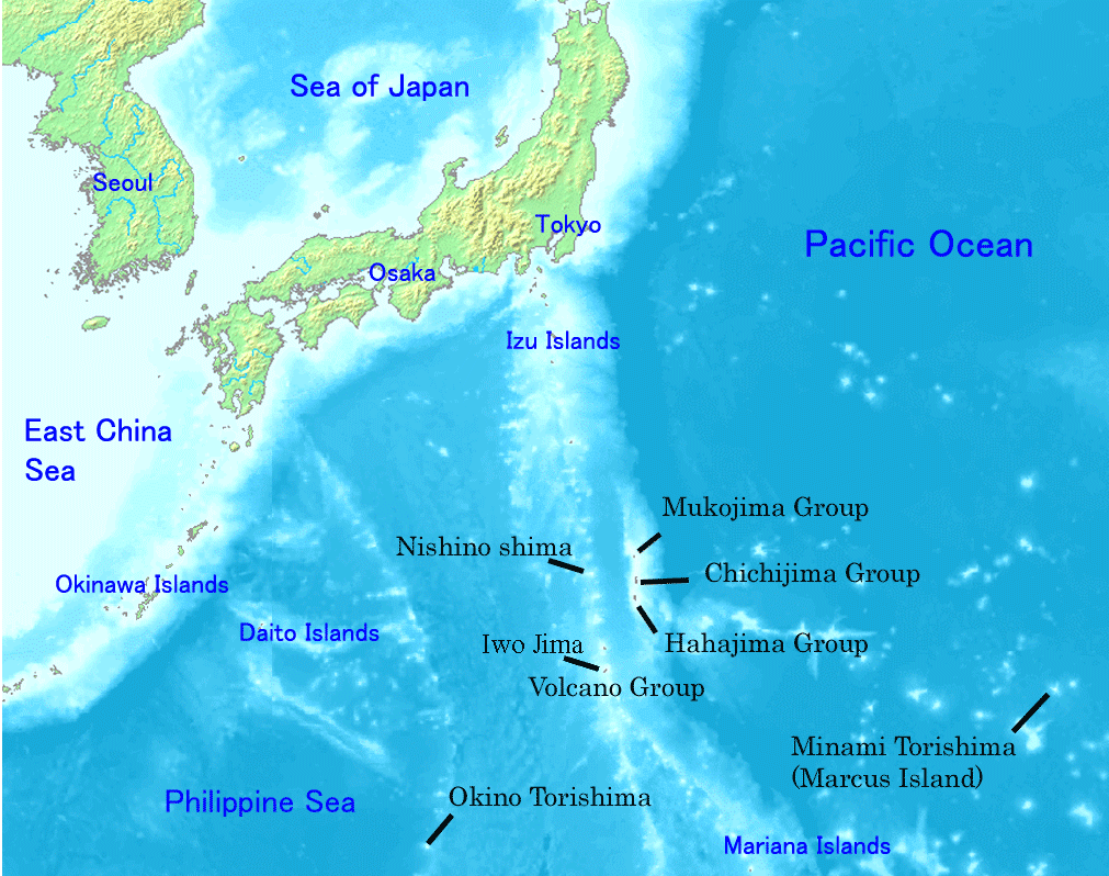
The Bonin Islands, also known as the Ogasawara Islands (Japanese: 小笠原諸島), are a Japanese archipelago of over 30 subtropical and tropical islands located around 1,000 kilometers (620 mi) SSE of Tokyo and 1,600 kilometers (1,000 mi) northwest of Guam. The group as a whole has a total area of 84 square kilometers (32 sq mi) but only two of the islands are permanently inhabited, Chichijima and Hahajima. Together, their population was 2,560 as of 2021. Administratively, Tokyo's Ogasawara Subprefecture also includes the settlements on the Volcano Islands and the Self-Defense Force post on Iwo Jima. The seat of government is Chichijima.
Because of the Bonins' isolation, many of their animals and plants have undergone unique evolutionary processes. They have been referred to as the "Galápagos of the Orient" and were named a Natural World Heritage Site in 2011. When first reached during the early modern period, the islands were entirely uninhabited, although subsequent research has found evidence of some prehistoric habitation by Micronesians. Upon their repeated rediscoveries, the islands were largely ignored by the Spanish, Dutch, and isolationist Japanese until finally being claimed by a passing British captain in 1827. American, European, and Hawaiian colonists arrived from the Kingdom of Hawaii in 1830. Subsequently, Meiji Japan successfully colonized and reclaimed the islands in 1875, but Bonin Islanders' community continued up to World War II, when most islanders were forcibly relocated to Honshu. Following Japan's defeat, the US Navy occupied the island, bulldozing existing Japanese homes and restricting resettlement until full control of the Bonins was returned to Japan in 1968. Ethnically, the island is now majority Japanese but remains unusually diverse, which is reflected in the local Creole language known as Bonin English. Improved transportation has made agriculture more profitable and encouraged tourism, but the development required for an airport remains a contentious local issue.
The name Bonin comes from an 1817 article in the French Journal des Savans by Jean-Pierre Abel-Rémusat in which—among various other misunderstandings of his source material—he misread a description of the islands as uninhabited (無人嶋, "desert island[s]") for their actual name, used the wrong reading of the characters (buninshima for mujintō), and then transcribed the resulting reading incorrectly into French as Bo-nin Sima, which eventually lost its original hyphen.
The name Ogasawara (小笠原; Japanese pronunciation: [ogasawaɾa]) literally means "little hat-shaped field(s)" but is used for the islands in honor of Ogasawara Sadayori (小笠原 貞頼), a supposed ancestor of the ronin Ogasawara Sadatō (小笠原 貞任) fictitiously credited with the discovery of the chain. Within Japanese, the Bonins proper are known as the "Ogasawara Islands" or "Group" (小笠原群島, Ogasawara-guntō) while the "Ogasawara Islands" or "Archipelago" (小笠原諸島, Ogasawara-shotō) is a wider term including the other islands of the Ogasawara Municipality (小笠原村, Ogasawara-mura) and its coterminous Ogasawara Subprefecture (小笠原支庁, Ogasawara-shichō)—namely, the Volcano Islands and three remote islands of Nishinoshima, Minamitorishima, and Okinotorishima. These islands are parts of Japan's Nanpō Islands.
The islands were also formerly known to Europeans as the Archbishop Islands (Spanish: Islas del Arzobispo), probably in honor of Pedro Moya de Contreras, archbishop of Mexico and viceroy of New Spain, who sent an expedition to the area in the late 16th century.
At the end of the 20th century, prehistoric tools and carved stones were discovered on North Iwo Jima and Chichijima, establishing that the islands were previously home to at least some members of an unknown Micronesian people.
The first recorded visit by Europeans to the islands happened on 2 October 1543, when the Spanish explorer Bernardo de la Torre on the San Juan sighted Haha-jima, which he charted as Forfana. The islands were uninhabited at that time. Japanese discovery of the islands occurred in Kanbun 10 (1670) and was followed by a shogunate expedition in Enpō 3 (1675). The islands were then referred to as Bunin jima (無人島, Buninjima), literally "the uninhabited islands". Shimaya Ichizaemon, the explorer at the order of the shogunate, inventoried several species of trees and birds, but after his expedition, the shogunate abandoned any plans to develop the remote islands.
The first published description of the islands in the West was brought to Europe by Isaac Titsingh in 1796. His small library of Japanese books included Sangoku Tsūran Zusetsu (三国通覧図説, An Illustrated Description of Three Countries) by Hayashi Shihei. This book, which was published in Japan in 1785, briefly described the Ogasawara Islands.
Hub AI
Bonin Islands AI simulator
(@Bonin Islands_simulator)
Bonin Islands
The Bonin Islands, also known as the Ogasawara Islands (Japanese: 小笠原諸島), are a Japanese archipelago of over 30 subtropical and tropical islands located around 1,000 kilometers (620 mi) SSE of Tokyo and 1,600 kilometers (1,000 mi) northwest of Guam. The group as a whole has a total area of 84 square kilometers (32 sq mi) but only two of the islands are permanently inhabited, Chichijima and Hahajima. Together, their population was 2,560 as of 2021. Administratively, Tokyo's Ogasawara Subprefecture also includes the settlements on the Volcano Islands and the Self-Defense Force post on Iwo Jima. The seat of government is Chichijima.
Because of the Bonins' isolation, many of their animals and plants have undergone unique evolutionary processes. They have been referred to as the "Galápagos of the Orient" and were named a Natural World Heritage Site in 2011. When first reached during the early modern period, the islands were entirely uninhabited, although subsequent research has found evidence of some prehistoric habitation by Micronesians. Upon their repeated rediscoveries, the islands were largely ignored by the Spanish, Dutch, and isolationist Japanese until finally being claimed by a passing British captain in 1827. American, European, and Hawaiian colonists arrived from the Kingdom of Hawaii in 1830. Subsequently, Meiji Japan successfully colonized and reclaimed the islands in 1875, but Bonin Islanders' community continued up to World War II, when most islanders were forcibly relocated to Honshu. Following Japan's defeat, the US Navy occupied the island, bulldozing existing Japanese homes and restricting resettlement until full control of the Bonins was returned to Japan in 1968. Ethnically, the island is now majority Japanese but remains unusually diverse, which is reflected in the local Creole language known as Bonin English. Improved transportation has made agriculture more profitable and encouraged tourism, but the development required for an airport remains a contentious local issue.
The name Bonin comes from an 1817 article in the French Journal des Savans by Jean-Pierre Abel-Rémusat in which—among various other misunderstandings of his source material—he misread a description of the islands as uninhabited (無人嶋, "desert island[s]") for their actual name, used the wrong reading of the characters (buninshima for mujintō), and then transcribed the resulting reading incorrectly into French as Bo-nin Sima, which eventually lost its original hyphen.
The name Ogasawara (小笠原; Japanese pronunciation: [ogasawaɾa]) literally means "little hat-shaped field(s)" but is used for the islands in honor of Ogasawara Sadayori (小笠原 貞頼), a supposed ancestor of the ronin Ogasawara Sadatō (小笠原 貞任) fictitiously credited with the discovery of the chain. Within Japanese, the Bonins proper are known as the "Ogasawara Islands" or "Group" (小笠原群島, Ogasawara-guntō) while the "Ogasawara Islands" or "Archipelago" (小笠原諸島, Ogasawara-shotō) is a wider term including the other islands of the Ogasawara Municipality (小笠原村, Ogasawara-mura) and its coterminous Ogasawara Subprefecture (小笠原支庁, Ogasawara-shichō)—namely, the Volcano Islands and three remote islands of Nishinoshima, Minamitorishima, and Okinotorishima. These islands are parts of Japan's Nanpō Islands.
The islands were also formerly known to Europeans as the Archbishop Islands (Spanish: Islas del Arzobispo), probably in honor of Pedro Moya de Contreras, archbishop of Mexico and viceroy of New Spain, who sent an expedition to the area in the late 16th century.
At the end of the 20th century, prehistoric tools and carved stones were discovered on North Iwo Jima and Chichijima, establishing that the islands were previously home to at least some members of an unknown Micronesian people.
The first recorded visit by Europeans to the islands happened on 2 October 1543, when the Spanish explorer Bernardo de la Torre on the San Juan sighted Haha-jima, which he charted as Forfana. The islands were uninhabited at that time. Japanese discovery of the islands occurred in Kanbun 10 (1670) and was followed by a shogunate expedition in Enpō 3 (1675). The islands were then referred to as Bunin jima (無人島, Buninjima), literally "the uninhabited islands". Shimaya Ichizaemon, the explorer at the order of the shogunate, inventoried several species of trees and birds, but after his expedition, the shogunate abandoned any plans to develop the remote islands.
The first published description of the islands in the West was brought to Europe by Isaac Titsingh in 1796. His small library of Japanese books included Sangoku Tsūran Zusetsu (三国通覧図説, An Illustrated Description of Three Countries) by Hayashi Shihei. This book, which was published in Japan in 1785, briefly described the Ogasawara Islands.
Recent media