
Community hub
Recent from talks
Contribute something
Nothing was collected or created yet.
Caterham
View on Wikipedia
Caterham (/ˈkeɪtərəm/) is a town in the Tandridge district of Surrey, England. The town is administratively divided into two: Caterham on the Hill, and Caterham Valley, which includes the main town centre in the middle of a dry valley but rises to equal heights to the south. The town lies close to the A22, 21 miles (34 kilometres) from Guildford and 6 miles (10 kilometres) south of Croydon, in an upper valley cleft into the dip slope of the North Downs. Caterham on the Hill is above the valley to the west.
Key Information


The town is particularly associated with being the location of the original factory for the Caterham 7 and for being the location of Caterham School, the estate of which lies on the outskirts of Caterham Valley.
History
[edit]An encampment on the top of White Hill, in Caterham Valley south of Caterham School, between Bletchingley and the town centre is called The Cardinal's Cap[2][3] which was excavated and inspected in designating it a Scheduled Ancient Monument. With close ramparts forming two or more lines, archaeologists describe the fort as a "large multivallate hillfort at War Coppice Camp".[4]
Its inner bank is about 0.5m wide and 0.4m high with a ditch 7m wide and 0.3m deep situated 2m below its crest. To the west of the ditch is the second bank, 8m wide and 0.5m high. Beyond this the second ditch has become completely infilled over the years but survives as a buried feature approximately 8m wide, visible as a terrace. Traces of a second, slighter terrace are situated further down the slope, representing evidence of additional scarping. The defences to the north east include an inner bank 5m wide and up to 0.5m high from the interior and 4m high from the exterior with a surrounding ditch 8m wide and 0.6m deep. Beyond this is a counterscarp bank 6m wide and up to 1m high. A 35m long section of a second ditch, which has become partially infilled over the years, survives 25m further out to the north east. In the southern and south eastern areas of the monument, sections of the hillfort have been disturbed by later quarrying activity. Although the monument was originally thought to be either Roman or Neolithic in date, excavations in 1950 showed it to be Iron Age and what had previously been thought to be a fragment of an earthwork was almost complete with the banks of the ramparts having been palisaded and revetted to strengthen their defence.[4]
The town lies within the Anglo-Saxon feudal division of Tandridge hundred.
Toponymy
[edit]The origin of the name Caterham is disputed and unknown. One theory is that it derives from the Primitive Welsh word cadeir meaning chair and the Old English hām meaning village. This could be in reference to a chair-shaped hill. Other theories derive it from the Old English cattahām or cattehām meaning 'Catta's settlement' or 'settlement of the cats'.[5]
Post Norman Conquest
[edit]Caterham's church of St Lawrence is of Norman construction and retains a rector as its incumbent. In the reign of King John, Roger son of Everard de Gaist gave this including its church lands to the monastery of Waltham Holy Cross. Everard's grandfather was Geoffery of Caterham who gave land to his son in the 12th century.[6] This monastery ran the glebe as a manor, receiving a grant of free warren in their demesne lands of Caterham in 1253;[3] holding it until the dissolution of the monasteries.
Caterham's original village centre consisted in the nearest part of the ridge of Caterham on the Hill to the railway station in Caterham Valley, including at the street ascending the relatively steep, short hill, Church Hill. Although no conservation area has been designated in either civil parish,[7][8] four secular buildings, including The King and Queen public house, three churches as well as a vault and tomb in St Lawrence's churchyard are listed; these are along Hill Street/ Church Hill in Caterham on the Hill.
The combined manors of Caterham, Porkele, Upwode, Gatiers and Halyngbury
[edit]Porkele had been formerly included in the manor given to Waltham Abbey; together the latter manors comprised 1,000 acres (400 hectares). Humphrey Stafford, 1st Duke of Buckingham (1402–1460) held these manors leaving them in 1458 to his third son John Stafford, 1st Earl of Wiltshire when his son died without issue in 1499, under the terms of grant the elder branch, the following Duke of Buckingham inherited. His heirs sold them on the dissolution to Lord Berners who died in debt in 1533 resulting in bona vacantia and seizure by the Crown. In 1570 Thomas Sackville, 1st Earl of Dorset (as Lord Buckhurst), later Lord High Treasurer, held the 'manor of Caterham and Portele farm,' which he conveyed in that year to Henry Shelley; Sir Thomas's Sondes's widow leased the lands in 1599 to her half-brother, Main Plot seditionist Henry Brooke, 11th Baron Cobham. Then in 1615 her daughter Frances Leveson gave the rest of that lease, due the tenant's attainder to Sir Edward Barrett and Walter Barrett while the reversion was held by Sir Richard Sondes. George Ede purchased this massive estate in 1612 and it passed to Jasper Ockley in 1616. Sir Isaac Shard who was one of two Sheriffs of the City of London in 1730 who conveyed it to Thomas Clark and then passed as with the other manors; in 1911 W. L. Williams its owner lived at Portley in what remained of the estate.[3] De Stafford School in Caterham on the Hill occupies a small part of the estate and is named after the earlier known owner. Adjoining Sunnydown School, state-run, is at what was Portley House[8] and is for secondary education for boys with a Statement of Special Educational Needs.
The Manor of Salmons
[edit]The only manor did not have as high-profile owners. In 1339 John de Horne released some land in Caterham (and more in Warlingham) to Roger Salaman, who at his death in 1343 was "seised of a tenement". A manor of Salmons appears in 1605 by William Jordan, who soon afterwards acquired the second manor of Caterham (see above) with which Salmons afterwards descended. It was bought out of Chancery, into which it went on the death of Charles Day, by George Drew, who sold to members of the Horne family, who owned the relatively small estate in 1911.[3]
Post Reformation
[edit]In 1544, the King granted the main rectorial manor was granted (in fee) to William Sackville JP[9] In 1553 William Sackville and Eleanor passed the manor to Robert Hartopp, goldsmith of London, dying two years later succeeded by Elias his son, who was left it to his nephew John, whose widow Joan sold the manor in 1609 to George Evelyn who gave it to his son Sir John Evelyn on his marriage to Elizabeth Cocks.[3] Later owners of the manor were Sir John's purchaser James Linch, his issue including Susan Hussey and her son James who sold the manor in 1699 to George Roffey. His nephew inherited it of the same name and in 1770 his sons sold the title alone and perhaps house to Matthew Robinson. Richard Hewetson bought it in 1780 passing it to his nephew Henry Hewetson holding until the Regency period. Henry's nephew William Hewetson ceased to lay claim to any manorial rights however in any event the lands had been separately sold to Henry Rowed, whose son Henry settled the estate on his wife Susan Glover in 1765.[3] Their daughter Katherine Glover inherited these lands.[3]
A second manor Manning and Bray report on was the main tenant's under the monastery and was held by for example buyers: William Jordan in 1607; Sir Isaac Shard (see above), who held his first court in 1726; after 1825 Charles Day of the firm of Day & Martin held but leaving no clear heirs this estate ended up in the hands of the chancery. Taxing (costs) judge George Henry Drew held the main lands and title followed by W. L. Williams in 1911.[3]
Post Industrial Revolution
[edit]_-_Geographicus_-_London24-mogg-1820.jpg)
Under Rev. James Legrew in the early 19th century the church tithes were commuted for £400, retaining a glebe of 5 acres (2.0 ha).[2]
In 1840 Caterham contained a total of 477 residents (figures taken from that census, compiled in an 1848 topographical encyclopedia) and in 1848 468 acres (189 ha) of its 2,386 acres (966 ha) were common land.[2] Similar to today, 175 acres (71 ha) mostly steeper acres were woodland.[2][10]
The more modern locality of Caterham Valley in a wide dry valley opening to the north (to Warlingham) and along its slopes is a product of the Victorian age and the coming of the Caterham railway line in 1856, which is still a terminus.
Victorian expansion of the town required the building of a much larger parish church, leading to the Church of St Mary the Virgin's building in 1866, directly across the road from St Lawrence's. As it also grew Caterham Valley gained its own Anglican church, to St. John the Evangelist, which was consecrated in 1882.

From 1877 Caterham Barracks on the hill was a depot for the Foot Guards regiments.[11] The barracks were closed in 1995 and the site was redeveloped for housing.[12]
Two main streets (there is only one road called High Street – Caterham on the Hill) therefore serve two very close yet substantial and affluent communities (see demographics), one with the railway station and more modern buildings, one with more historic buildings as soon as the closest hill (to the northwest) is climbed from the heart of Caterham Valley.[8] This set-up means that localism is present in that the Godstone Road during the middle of the 20th century bypassed Caterham Valley staying high and using Tillingdown, along the east of Caterham Valley from St John's School to the Croydon Road roundabout, thereby removing A22 traffic, while businesses set up and thrived in the valley itself.
On 6 July 1974 PC John Schofield was shot and killed while on patrol in Caterham.[13]
In 1975 an IRA bomb exploded in the Caterham Arms public house injuring 10 off-duty soldiers and 23 civilians. The pub was popular with the Welsh Guards, who had recently returned to Caterham Barracks after serving in Northern Ireland. The men responsible for the bombing were later jailed for a string of murders and bombings; they were released in April 1999 following the Good Friday Agreement.[14]
Local government
[edit]
There are three tiers of local government in Caterham, at parish, district, and county level. The town is split between two civil parishes: Caterham on the Hill covering the older hilltop village, and Caterham Valley covering the newer town which grew up around Caterham railway station at the foot of the hill. Both parishes are within Tandridge District, which is based in Oxted, whilst county-level services are provided by Surrey County Council, based in Reigate.
Surrey County Council has two councillors from Caterham.
| Election | Member[15] |
Ward | |
|---|---|---|---|
| 2021 | Jeremy Webster | Caterham Hill | |
| 2021 | Jeffrey Gray | Caterham Valley | |
Caterham has ten representatives on Tandridge District Council:
| Election | Member[16] |
Ward | |
|---|---|---|---|
| 2024 | Robin Spencer | Harestone | |
| 2022 | Annette Evans | Harestone | |
| 2024 | Ben Horne | Portley & Queens Park | |
| 2024 | Richard Mark | Portley & Queens Park | |
| 2004 | Michael Cooper | Portley & Queens Park | |
| 2016 | Alun Jones | Valley | |
| 2021 | Jenny Gaffney | Valley | |
| 2024 | James Rujbally | Westway | |
| 2024 | Ankita Sharma | Westway | |
| 2024 | Sarah Sowambur | Westway | |
Caterham has two civil parish councils: Caterham on the Hill and Caterham Valley. Caterham Valley parish has two wards, Harestone and Caterham Valley, each electing three elected parish councillors.[17] The parish council clerk is Maureen Gibbins.[18] Caterham on the Hill has three wards, Portley, Queen's Park and Westway, each electing three parish councillors.[19] The parish council clerk is Helen Broughton.[20]
Administrative history
[edit]
The ancient parish of Caterham was part of the Tandridge Hundred.[21] The parish was included in the Godstone Poor Law Union in 1835.[22] When parish and district councils were established in 1894 under the Local Government Act 1894, Caterham was given a parish council, which was subordinate to the Godstone Rural District Council. Less than five years later, the parish of Caterham was removed from Godstone Rural District, becoming its own urban district on 1 April 1899, with the Caterham Parish Council being replaced with Caterham Urban District Council.[23] Caterham Urban District Council held its first meeting on 17 April 1899 at the Masonic Hall, when William Garland Soper was appointed the first chairman of the council, having previously been chairman of the short-lived parish council.[24]
In 1911 Caterham Urban District Council built itself a public hall and office building called Soper Hall, at 3 Harestone Valley Road, to serve as its headquarters. The building was named after William Garland Soper, the first chairman of the council, who had died in 1908. Of the building's £4,000 cost, £1,500 was donated by public subscription in memory of Soper.[25] The building was formally opened in January 1912.[26]
In 1929 the Caterham Urban District was enlarged by the addition of the neighbouring parish of Warlingham, and the district's name was changed to Caterham and Warlingham Urban District. In 1933 the parishes of Chaldon and Woldingham were also added to the urban district. Caterham, Chaldon, Warlingham and Woldingham remained separate civil parishes, but as urban parishes they no longer had separate parish councils, with Caterham and Warlingham Urban District Council being the smallest representative body covering the whole urban district.[27] Caterham and Warlingham Urban District Council continued to be based at Soper Hall, and also acquired a large house next door at 1 Harestone Hill to serve as additional office space. In 1951 the parish had a population of 19,844.[28] On 1 April 1974 the parish was abolished.[29]
Caterham and Warlingham Urban District was abolished under the Local Government Act 1972, with the area merging with neighbouring Godstone Rural District to become Tandridge District on 1 April 1974.[30] For its first few years Tandridge District Council used the offices of both its predecessor districts in Caterham and Oxted, until 1989 when it moved to new offices in Oxted on the site of the old Godstone Rural District Council's buildings. The new building in Oxted was funded by the sale of most of the old Caterham and Warlingham council's properties around 1 Harestone Hill to make way for part of a retail development called Church Walk, with only Soper Hall being retained.[31][32]
No successor parish was created for the former Caterham and Warlingham Urban District at the time of the 1974 reforms, and the area therefore became an unparished area, directly administered by Tandridge District Council. Civil parishes were re-established for the area in 2000, with the former urban district being split into six parishes: Caterham on the Hill, Caterham Valley, Chaldon, Warlingham, Whyteleafe, and Woldingham.[33]
Geography
[edit]


Caterham is 21 miles (34 kilometres) from the county town of Guildford and 15+1⁄2 miles (25 kilometres) south of London.[34]
Caterham on the Hill is located on a considerable area of upland extending north past adjoining Kenley Aerodrome to Kenley and Hartley Hill in Reedham. This elevated area carries on west until Hooley/Old Merstham and forms a very narrow, fairly steep ridge south of Caterham Valley's centre; east of the centre of Caterham Valley are marginally higher rolling pastures of the North Downs on top of a more crevassed smaller mass of upland which forms the village of Woldingham followed by a much larger area of upland stretching from Biggin Hill to Downe and Knockholt, Kent.[8]
The M25 motorway (between junctions 6 and 7) is 80 to 90m below and less than 200m south of the North Downs path and the southern border of Caterham Valley civil parish and is linked by an uninterrupted hilltop dual carriageway to the north of Caterham and its lowest point, Croydon Road roundabout. [35]
In the south of Caterham are the following hills:
| Hill | Elevation | Rank within Surrey | Range |
|---|---|---|---|
| Gravelly Hill | 236m | 7th | North Downs |
| White Hill | 233m | 10th | North Downs[36] |
Elevation, soil and geology
[edit]The parish is on the Chalk downs, but they are in great part capped by clay and gravel[3]
Elevations range from the height above in the southwest extreme at "Whitehill Tower, War Coppice Road in Caterham Valley" to 110m Above Ordnance Datum along the railway track, immediately below Croydon Road roundabout, a tripoint partly in Woldingham, Whyteleafe and Caterham.[37]
Caterham lies within the North Downs and Caterham Valley's southern border is immediately south of the North Downs Way, part of a national trail network, which is here on top of the southern edge of the North Downs.[38]
Soil here has the expected shallow, lime-rich soil over chalk or limestone of the escarpment with lower parts of the escarpment summit here, where the topsoil has eroded, having slightly acid, loamy and clayey soils with impeded drainage, which makes that soil particularly fertile.[39]
The gault clay and the middle chalk that lies under the North Downs are both at their thickest around the valley that occupies the centre of Caterham Valley.[40] While earlier cretaceous clays and greensand and sandy material, underlying, is evident where terrain has eroded, 90 million years ago the North Downs hard chalk was deposited, a white limestone comprising over 95% calcium carbonate. It contains thin beds of marl and nodules of flint, either scattered or in bands. The North Downs extending from Farnham to Dover are formed by this chalk. They now have an often white, almost vertical south-facing slope. In lower slopes flints washed up by early seas come more to the surface and appear closer to the surface.[2][41]
Landmarks
[edit]The North Downs Way, a National trail popular with walkers, passes very close to the town and is readily accessible from either Harestone Valley Road or Tupwood Lane, the Celtic hillfort promontory of the Downs mentioned above, The Cardinal's Cap, and Fosterdown or Pilgrims' Fort, a London Defensive Fort at the top of part of the ridge forming Godstone Hill, in Caterham Valley.[8]
Whitehill Tower is a folly built south west of the town, alongside War Coppice Road, by local landowner Jeremiah Long in 1862.[42][3]
Localities
[edit]Caterham Valley
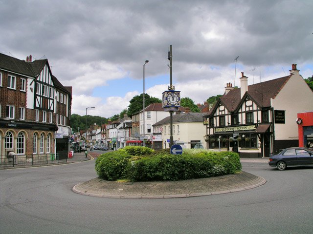
[edit]The civil parish of Caterham Valley has the more developed shopping area presenting the main town centre for the whole community and has a population of 7,581.[43] The parish church of St. John the Evangelist was consecrated in 1882. The railway station is a terminus in the central, dry valley at the heart of this very large neighbourhood. Traffic to and from the London and Croydon to the north heading towards the M25 motorway is routed around the town on the A22 over the Caterham Bypass, opened in 1939 as one of the earliest such roads in the country. Caterham School is a large independent co-educational day and boarding school situated along the sides of the Harestone Valley. North Downs Hospital is small private establishment on the outskirts of the town run by the Ramsay Health Care UK.[44] Part of Caterham Valley Business Community is represented by a business improvement district, which is publicly known as Caterham Valley For You.[45] Caterham Police Station, operated by Surrey Police is located in the middle of the valley; the local St John Ambulance unit shares the building.
Caterham on the Hill
[edit]
Caterham on the Hill is the second of the two civil parishes. This clustered development or village is directly to the northwest of the other entire Valley part of the town and does not have steep slopes or a wide divide between upland and downland developments unlike Caterham Valley. It has a population of 11,555;[46] it was the original development in the area so has more listed buildings compared to Caterham Valley, which has a few early Victorian outlying homes and its church listed. The only state run secondary school is in this part of the town, but it has two private primary schools.
- Former barracks
The Caterham Barracks Trust[47] run some facilities at the site of the former Caterham Barracks. The site is occupied by a supermarket, a housing estate comprising social and some private housing, and various leisure facilities including an arts centre (The Arc), and an indoor Skate park (Skaterham)[48] housed in the former Guard's chapel.
Terry Waite[49] and David Stirling (the founder of the SAS) trained at the barracks.
A number of films / TV series were fully or partially filmed at the barracks. They Were Not Divided filmed by Two Cities Films[50] and Invasion: Earth series filmed by the BBC.
- Mental Hospitals
Caterham Asylum, later known as Caterham Mental Hospital and later still as Saint Lawrence's Hospital, was a very large establishment for the treatment of the mentally ill. Patients came from all over London to this well known institution that by 1930 grew to over 2,000 beds.[51] Joey Deacon lived in the hospital or its grounds for over 50 years. Most of the site has now been redeveloped as housing but a few buildings remain, although they are now empty and planning permission has been given for the buildings to be demolished and 161 homes built on the site. Joey Deacon's bungalow 'Holland House' is scheduled for demolition but the 'Blue Peter' bungalow 'Woodview' is to remain as a care home.
- Hospital
Caterham on the Hill has its own small NHS hospital, Caterham Dene, run by First Community Health and Care CIC offering a range of inpatient and outpatient services, including a minor injury unit.[52]
Demography and housing
[edit]At the 2011 census, Caterham has a total population of 21,090 people among 8,543 households, an increase of 130 households in 10 years.
| Output area | Detached | Semi-detached | Terraced | Flats and apartments | Caravans/temporary/mobile homes | Shared between households[1] |
|---|---|---|---|---|---|---|
| Caterham on the Hill | 1,185 | 1,666 | 963 | 1,208 | 0 | 0 |
| Caterham Valley | 1,034 | 854 | 229 | 1,393 | 11 | 0 |
The average level of accommodation in the region composed of detached houses was 28%, the average that was apartments was 22.6%.
| Output area | Population | Households | % Owned outright | % Owned with a loan | hectares[1] |
|---|---|---|---|---|---|
| Caterham on the Hill | 12,742 | 5,022 | 31.2% | 44.7% | 353 |
| Caterham Valley | 8,348 | 3,521 | 33.6% | 40.2% | 588 |
The proportion of households in the civil parish who owned their home outright compares to the regional average of 35.1%. The proportion who owned their home with a loan compares to the regional average of 32.5%. The remaining % is made up of rented dwellings (plus a negligible % of households living rent-free).[1]
Commerce
[edit].jpg)
Church Walk
[edit]Church Walk Shopping Centre is a small shopping mall situated opposite Caterham railway station in Caterham Valley. Church Walk was built on the site of the Valley Hotel, which was demolished in 1988. Long before the Valley Hotel was built (to cater for visitors arriving on the new railway trains) there used to be a tennis court, croquet lawn, rose garden, fountain, and Mr. Woollet's nursery.
Local companies
[edit]Until 1987 the offices, factory and showroom Caterham Cars, makers of the Caterham 7 sports car were located in Caterham when the company moved to a new factory in Kent but retained a Caterham South showroom – but leaving the town by moving to Crawley in February 2013. The former show room that they occupied has now been turned into more homes for retired people.
The house building company, Croudace, have their head office in Caterham. Caterham and DeStafford Schools and several supermarket chains are also large local employers. The Town had a large vacant building – The Rose and Young building – which has now been demolished after over twenty years. This site has since been developed into a Lidl supermarket and flats.
The High Street, on The Hill, has a variety of small, independent shops. Parking is free for three hours in the main car park, at the top end of town.
Transport
[edit]
Caterham railway station is the terminus of the 1856-built Caterham line from Purley. Trains operate to London Bridge only.
Eight bus routes operate through Caterham, with half being operated by Metrobus. They run buses from Caterham to places such as East Grinstead, Croydon, Redhill and Oxted. Of the remaining five routes, buses are run by: London General to Coulsdon, Transport UK London Bus to Coulsdon and Sutton; Arriva London to Addington Village; and Metrobus to East Grinstead.[53]
Sport
[edit]Caterham has a youth football club. Caterham Pumas FC. The Old Caterhamians Rugby Football Club, was established in 1928. Caterham Cricket Club previously played in Queen's Park and now share facilities with the rugby club. Caterham Sea Cadets, formed in 1942, also participate in a number of watersports activities.[citation needed]
Caterham Pumas Football Club play their matches at Joliffe Playing Field. They have youth football teams for children under six to those under eighteen, and two adult teams.
Media
[edit]Television signals are received from the Crystal Palace TV transmitter [54] and the local relay transmitter which broadcast BBC London and ITV London programmes.[55]
The town is served by both BBC Radio Surrey and BBC Radio London. Other radio stations including Heart South, Greatest Hits Radio Surrey & North-East Hampshire and Ridge Radio, a community based station that broadcast from the town.[56]
Local newspapers are The Caterham Independent and Caterham Mirror.[57][58]
Education
[edit]
Caterham has a mixture of state and private schools. Three private schools in Caterham are Caterham School established at its present site since 1884, which is in the outskirts of the town, Oakhyrst Grange School and Essendene Lodge School. The main state secondary school is de Stafford School. A secondary school for boys with special educational needs called Sunnydown School is also in Caterham on the Hill.[59]
Culture and community
[edit]This section needs additional citations for verification. (May 2021) |
A children's ball pit and gymnastics centre are situated in the old Caterham Barracks housing estate. The building is made out of the two converted gymnasiums. There is a skatepark called "Skaterham" in Caterham on The Hill. It has indoor and outdoor sections, built on the grounds of the former Guards Chapel.
Based in the town centre the Miller Centre is a theatre and community centre that puts on regular non-professional shows, films and is host to a number of clubs and community groups. Croydon Gymnastics Club are based in the gymnastics centre on the high street, which also has a dance studio.
The small East Surrey Museum houses a local history collection.
An annual carnival is held in the town, with a procession of floats and a fete.[60]
Caterham has an online radio station for the community, called Ridge Radio.[61]
The first Caterham Festival[62] was in 2009 and by 2014 there were 135 events spread over 5 weeks. There is a 2-day music fest, the High Street is closed for a town street party and the main road through the Valley is closed for a food fest. Other events include Shakespeare plays, an archaeological dig, open Caterham – where buildings and groups open their doors for the weekend, concerts and comedy nights. The annual Carnival takes place during the Festival. The Festival has won a number of awards including the Action for Market Towns best community event and, on three occasions, the Surrey Mirror Heart of the Community award. Chairman Andy Parr has been awarded the M.B.E. for services to the Community of Caterham.
The committee members have also advised many other towns about holding similar Festivals.[63]
Religion
[edit]Caterham has churches representing a variety of Christian denominations. The oldest church remaining in use is the church of St. Lawrence, which was established around 1095. The church has been used by several different denominations, including Quakers and Romanian Orthodox.[64] It was largely replaced from 1866 onwards, following the consecration of the church of St. Mary the Virgin. Both of these churches are located in Caterham on the Hill.[65]
As the town in the valley expanded after the railway was built, several churches were founded. Caterham United Reformed Church was built by nonconformists in 1863,[66] followed by the Church of St. John the Evangelist in 1881.[67]
Notable people
[edit]The composer Mátyás Seiber lived at 169 Stafford Road from 1935 until his death in 1960. Television presenter Angus Deayton grew up in Caterham; he attended both Oakhyrst Grange and Caterham Schools.[68] Notable sportspeople born in the town include the footballers Nicky Forster[69] and David Price[70] and cricketer Dar Lyon.[71] Actors Bill Nighy[72] and Jon Finch were also born in Caterham; Michael Robbins, another actor, died there.[citation needed] BTCC racer Mikey Doble was born in Caterham.[73] Sir Bernard Ingham, Margaret Thatcher's prime ministerial press secretary, lived his last years and died in Caterham.[74]
See also
[edit]References
[edit]- ^ a b c d "Key Statistics; Quick Statistics: Population Density (2011 Census)". Office for National Statistics. Archived from the original on 11 February 2003. Retrieved 21 November 2013.
- ^ a b c d e Samuel Lewis, ed. (1848). "Caston – Catterick". A Topographical Dictionary of England. Institute of Historical Research. Archived from the original on 26 October 2012. Retrieved 6 November 2012.
- ^ a b c d e f g h i j H.E. Malden, ed. (1912). "Parishes: Caterham". A History of the County of Surrey: Volume 4. Institute of Historical Research. Archived from the original on 9 February 2013. Retrieved 6 November 2012.
- ^ a b Historic England. "Large multivallate hillfort at War Coppice Camp (1008498)". National Heritage List for England. Retrieved 6 November 2012.
- ^ http://kepn.nottingham.ac.uk/map/place/Surrey/Caterham
- ^ Stowe manuscript 942, folio 262b
- ^ "Conservation Areas in Tandridge District". Archived from the original on 31 May 2013. Retrieved 6 November 2012.
- ^ a b c d e "Map created by Ordnance Survey, courtesy of English Heritage". Archived from the original on 24 April 2012.
- ^ Patent Roll 36 Henry VIII, pt. xxviii, manuscript 30.
- ^ "OpenStreetMap". OpenStreetMap. Archived from the original on 23 February 2011. Retrieved 7 November 2012.
- ^ Geoff Hare. "The Guards and Caterham". Caterham Barracks Community Trust. Archived from the original on 23 February 2013. Retrieved 27 July 2012.
- ^ "Caterham Barracks – a brief development summary". Caterham Barracks Community Trust. Archived from the original on 23 February 2013. Retrieved 27 July 2012.
- ^ "History of Surrey Police – Murder of PC John Schofield". Surrey Police. Archived from the original on 10 March 2012. Retrieved 3 March 2012.
- ^ "History from the police Archives, Robert Bartlett". Archived from the original on 15 October 2013. Retrieved 15 October 2013.
- ^ "Surrey's County councillors". Surrey County Council. 3 February 2012. Archived from the original on 10 October 2011. Retrieved 2 March 2012.
- ^ "Councillors". Tandridge.gov.uk. Tandridge District Council. Archived from the original on 11 January 2016. Retrieved 1 December 2013.
- ^ "Your Councillors". Caterham Valley Parish Council. 2014. Archived from the original on 14 July 2014. Retrieved 10 July 2014.
- ^ "Tandridge District Council". Archived from the original on 15 October 2013. Retrieved 15 October 2013.
- ^ "Your Parish Councillors". Caterham Hill Parish Council. 2014. Archived from the original on 14 July 2014. Retrieved 10 July 2014.
- ^ "Tandridge District Council". Archived from the original on 8 September 2011. Retrieved 2 March 2012.
- ^ Malden, H. E. (1912). A History of the County of Surrey, Volume 4. London: Victoria County History. pp. 265–270. Retrieved 19 July 2022.
- ^ Higginbotham, Peter. "Godstone Workhouse". The Workhouse. Retrieved 18 July 2022.
- ^ Annual Report of the Local Government Board. London: Her Majesty's Stationery Office. 1899. pp. 313, 319. Retrieved 19 July 2022.
The County of Surrey (Caterham Urban District) Confirmation Order 1899
- ^ "Caterham Urban Council: The first meeting". Croydon Chronicle. 22 April 1899. p. 6. Retrieved 19 July 2022.
- ^ "New U.D. Council Offices at Caterham". Surrey Mirror. Reigate. 19 August 1910. p. 8. Retrieved 19 July 2022.
- ^ "Caterham's new council offices". Croydon Chronicle. 13 January 1912. p. 19. Retrieved 19 July 2022.
- ^ "Caterham and Warlingham Urban District". A Vision of Britain through Time. GB Historical GIS / University of Portsmouth. Retrieved 19 July 2022.
- ^ "Population statistics Caterham AP/CP through time". A Vision of Britain through Time. Retrieved 27 April 2024.
- ^ "Surrey South-Eastern Registration District". UKBMD. Retrieved 27 April 2024.
- ^ Robert Simonson (29 February 2012). "The administrative boundaries of the county of Surrey". Surrey County Council. Archived from the original on 13 March 2012. Retrieved 3 March 2012.
- ^ "Oxted makes history". Caterham Mirror. 21 July 1988. p. 1. Retrieved 18 July 2022.
Chairman of Tandridge District Council Cllr John Rawling laid the foundation stone to the Council's new offices in Oxted on Friday...
- ^ "We are coming to Oxted". Dorking and Leatherhead Advertiser. 4 May 1989. p. 42. Retrieved 18 July 2022.
We will be moving into the offices in July...
- ^ "The Tandridge (Parishes) Order 1999" (PDF). Local Government Boundary Commission. Archived from the original (PDF) on 20 March 2022. Retrieved 19 July 2022.
- ^ "Miles between Guildford Surrey and Caterham N7 Surrey". Archived from the original on 4 January 2017. Retrieved 3 March 2012.
- ^ Dorking, Box Hill and Reigate: Leatherhead and Caterham (Map). 1 : 25,000. Explorer 146. Ordnance Survey. 2008. ISBN 978-0-319-24007-6.
- ^ "Database of British and Irish Hills". Archived from the original on 5 August 2018. Retrieved 6 March 2015.
- ^ "Grid reference Finder measurement tools". Archived from the original on 22 November 2012. Retrieved 22 January 2021.
- ^ "Home – North Downs Way – National Trails website". Natural England. Archived from the original on 9 March 2012. Retrieved 3 March 2012.
- ^ "Cranfield University National Soil Resources Institute". Archived from the original on 2 June 2013. Retrieved 6 November 2012.
- ^ "The geology of the county of Surrey". Surrey Museums. November 2006. Archived from the original on 29 February 2012. Retrieved 3 March 2012.
- ^ "Natural England – Geodiversity]". Archived from the original on 2 October 2013.
- ^ "Whitehill Tower, Caterham, Surrey". Folly Flaneuse. 10 June 2022. Retrieved 26 June 2023.
- ^ "Census data". Archived from the original on 15 October 2013. Retrieved 15 October 2013.
- ^ "North Downs Hospital". Ramsay Health Care UK Operations Limited. 2014. Archived from the original on 9 July 2014. Retrieved 10 July 2014.
- ^ "Caterham Valley For You". Caterham BID. 2017. Retrieved 29 March 2023.
- ^ "Census data". Archived from the original on 15 October 2013. Retrieved 15 October 2013.
- ^ "Caterham Barracks Trust". Archived from the original on 24 February 2012. Retrieved 27 July 2012.
- ^ "Skaterham". Archived from the original on 15 October 2013. Retrieved 15 October 2013.
- ^ "The Guards and Caterham, The Soldiers Story". Archived from the original on 16 July 2011.
- ^ "The Bourne Society, Village Histories: Caterham". Archived from the original on 20 April 2012.
- ^ "The asylum described". AIM25. Archived from the original on 13 September 2013.
- ^ "The Caterham Dene". Archived from the original on 8 July 2009. Retrieved 15 October 2013.
- ^ "Redhill and East Surrey bus timetables". Surrey County Council. 28 August 2012. Archived from the original on 5 June 2012. Retrieved 5 September 2012.
- ^ "Full Freeview on the Crystal Palace (Greater London, England) transmitter". UK Free TV. 1 May 2004. Archived from the original on 5 April 2016. Retrieved 1 December 2023.
- ^ "Freeview Light on the Caterham (Surrey, England) transmitter". UK Free TV. 1 May 2004. Retrieved 1 December 2023.
- ^ "Ridge Radio". Retrieved 1 December 2023.
- ^ "The Caterham Independent". Retrieved 1 December 2023.
- ^ "Caterham Mirror". British Papers. 26 November 2013. Retrieved 1 December 2023.
- ^ "Sunnydown". Archived from the original on 12 February 2012. Retrieved 2 March 2012.
- ^ Peter Wood (1998). "My memories of Caterham Carnival". Caterham & District Carnival. Archived from the original on 30 August 2012. Retrieved 24 September 2012.
- ^ "Ridge Radio Website". Archived from the original on 22 January 2013. Retrieved 24 February 2013.
- ^ "Caterham Festival | Fun for All the Family". www.caterhamfestival.org.
- ^ "Home - Caterham FestivalCaterham Festival | A Festival for Caterham People by Caterham People". Archived from the original on 29 October 2020. Retrieved 22 January 2021.
- ^ "St. Lawrence's Ancient Church". St. Mary's – Caterham team ministry. Archived from the original on 13 April 2012. Retrieved 22 September 2012.
- ^ "St. Mary's Church". St. Mary's – Caterham team ministry. Archived from the original on 24 December 2012. Retrieved 22 September 2012.
- ^ "Transcript: Any Questions? 22 May 2006". BBC. 22 May 2006. Archived from the original on 8 August 2007. Retrieved 22 September 2012.
- ^ "Church of St John, Caterham Valley". British Listed Buildings. Archived from the original on 11 January 2016. Retrieved 22 September 2012.
- ^ Vanessa Thorpe (18 April 2004). "The Observer Profile: Angus Deayton". The Observer. Archived from the original on 18 June 2018. Retrieved 22 September 2012.
- ^ "Caterham". Barry Hugman's Footballers. Archived from the original on 8 June 2024. Retrieved 14 November 2019.
- ^ "David Price". UK A–Z Transfers. Neil Brown. Retrieved 14 February 2010.
- ^ "Mr. M. D. Lyon—Cambridge And Somerset". Obituaries. The Times. No. 55938. London. 18 February 1964. col. E, p. 12.
- ^ Barratt, Nick (11 November 2006). "Family Detective". Archived from the original on 11 January 2022 – via www.telegraph.co.uk.
- ^ "Mikey Doble - Driver Info". BTCC. Retrieved 20 April 2023.
- ^ Bolton, Will (24 February 2023). "Sir Bernard Ingham, Margaret Thatcher's former press secretary, dies aged 90". The Daily Telegraph. ISSN 0307-1235. Retrieved 24 February 2023.
External links
[edit]- History of Caterham Village
- Page for Caterham in Kelly's Directory of Kent, Surrey & Sussex, 1891
- Surrey County Council. "Caterham". Exploring Surrey's Past. Retrieved 31 May 2017.
Neighbouring Places | ||||||||||||||||
|---|---|---|---|---|---|---|---|---|---|---|---|---|---|---|---|---|
| ||||||||||||||||
| Settlements (grouped by associated post town) |
|  | ||||||||||||||||||
|---|---|---|---|---|---|---|---|---|---|---|---|---|---|---|---|---|---|---|---|---|
| Places of worship | ||||||||||||||||||||
| Education | ||||||||||||||||||||
| Transport |
| |||||||||||||||||||
| Buildings and structures |
| |||||||||||||||||||
| Sport |
| |||||||||||||||||||
The administrative centre is Oxted. The largest town is Caterham. Three of the post towns have urban centres Caterham, Godstone and Oxted. Lingfield and Warlingham are major villages which have post town status. The others are outside the area. | ||||||||||||||||||||
| International | |
|---|---|
| National | |
| Geographic | |
| Other | |
Caterham
View on GrokipediaCaterham is a market town and civil parish in the Tandridge District of Surrey, England, located in a valley on the North Downs approximately 17 miles south of central London.[1][2] The town comprises the distinct areas of Caterham Valley and Caterham-on-the-Hill and had a population of 22,747 at the 2021 census.[3] Its modern development accelerated after the opening of the Caterham railway branch line in 1856, transforming it from a small village into a commuter settlement with easy access to London via rail and proximity to the M25 motorway.[4][5] Key institutions include the independent co-educational Caterham School, founded in 1811, and Caterham Cars, established as a dealer in 1959 and beginning production of the iconic Seven sports car in 1973 based on the Lotus Seven design.[6][7] Historically, the area features remnants of Roman roads and served as a site for institutions like the Caterham Asylum, opened in 1870, reflecting its evolution amid the Surrey Hills landscape.[8]
History
Origins and early settlement
The name Caterham derives from Old English, likely denoting the "homestead or village associated with Catta or Catte" (a personal name) or alternatively "wild cat homestead," with ham signifying a homestead or village; another interpretation links it to a hill named Cadeir (meaning "chair" in a Celtic-derived term), suggesting early topographic or faunal associations.[9] This etymology points to an Anglo-Saxon foundation, consistent with the broader pattern of settlement in the Tandridge hundred, an administrative division established by the 7th century for royal and ecclesiastical oversight in Surrey.[1] Archaeological evidence for pre-Anglo-Saxon occupation in Caterham remains sparse, with no confirmed prehistoric or Roman sites directly within the core settlement area, though nearby Gravelly Hill features earthworks including potential ancient field systems indicative of multi-period land use predating the medieval era. The original settlement nucleus lay on the elevated ridge now known as Caterham-on-the-Hill, exploiting the North Downs' defensive topography and proximity to ancient routeways, including vestiges of Roman-era paths along the Downs escarpment.[1] Caterham first appears in written records in the Domesday Book of 1086, enumerated as a manor in the Wallington hundred with arable land, meadows, woodland, and livestock supporting a modest agrarian economy under pre-Conquest holders, reflecting continuity from late Anglo-Saxon farming communities rather than post-Norman innovation.[10] The entry notes divisions of the estate, including parts held by ecclesiastical lords, underscoring early ties to church institutions amid the manorial system's consolidation following the Norman invasion.[10] By this period, a church dedicated originally to St. Leonard—later rededicated to St. Lawrence—likely served the community, evidencing organized Christian settlement by the 11th century.[8]Medieval manors and post-Norman development
In the Domesday Book of 1086, a manor in Tandridge Hundred—likely corresponding to Caterham or an adjacent holding—was recorded as held by Hugh under Odo, Bishop of Bayeux, reflecting the redistribution of lands following the Norman Conquest of 1066.[11] Post-Conquest development centered on a manorial agrarian economy, with tenants providing labor and rents to lords amid fragmented estates that evolved through grants, disputes, and noble inheritance.[11] The area remained rural, supporting arable farming and woodland resources under seigneurial control, with no evidence of significant urban growth until later centuries. The principal manor of Caterham passed to Waltham Abbey in the early 12th century via a grant from Roger son of Everard de Gaist during the reign of King John (1199–1216), including rights to the local church.[11] A legal dispute over the advowson (right to appoint the priest) emerged in 1245 between layman John Haunsard and the abbey, underscoring tensions between ecclesiastical and secular interests in manorial patronage.[11] By 1253, Waltham Abbey secured a royal grant of free warren, allowing exclusive hunting rights and reinforcing its economic dominance over the estate.[11] Several sub-manors consolidated under noble oversight by the mid-15th century, held by Humphrey Stafford, 1st Duke of Buckingham: Porkele (integrated into the main Caterham holding), Upwode (valued at 26s. 8d. annually), Gatiers (20s. 6d.), and Halyngbury (13s. 4d.), with Caterham itself assessed at 20s.[11] These were settled that year (1458) on John Stafford, Earl of Wiltshire, indicating strategic family alliances amid the Wars of the Roses.[11] The lesser Manor of Salmons followed a distinct trajectory, with limited medieval records but eventual descent outside the Buckingham line.[11] Religious infrastructure anchored community life, exemplified by St. Lawrence's Church, constructed around 1100 with Norman features including a semi-circular apse, later expanded in the 12th and 13th centuries to include a chancel, chapel, and aisles.[11] [12] By the early 16th century, following Edward Stafford, 3rd Duke of Buckingham's attainder for alleged treason in 1521, the Crown seized the combined manors, marking a shift toward post-medieval reconfiguration after the Dissolution of the Monasteries.[11] In 1544, Caterham manor was regranted to William Sackville, signaling continuity in gentry management amid Tudor land reforms.[11]Reformation to pre-industrial era
Following the Dissolution of the Monasteries in the 1530s, the principal manor of Caterham, previously held by Waltham Abbey, was granted by the Crown to William Sackville in 1544.[11] Ownership passed shortly thereafter to Robert Hartopp in 1553, remaining with the Hartopp family until George Evelyn acquired it in 1609.[11] Evelyn sold the manor to James Linch, who died in 1640; it then descended to his daughter Susan Hussey and her son Robert Hussey before being purchased by George Roffey in 1699.[11] By 1770, the Roffey brothers conveyed their shares to Matthew Robinson, who transferred the estate to Richard Hewetson in the 1780s.[11] A secondary manor emerged through subdivisions, with records showing ownership by William Richebell in 1577, followed by the Pratt family and then William Jordan, whose descendant Edmund Jordan held it into the early 18th century.[11] Sir Isaac Shard convened the first recorded court baron for this manor in 1726, after which it passed to William Shard and later Thomas Clark in 1790.[11] Other holdings, such as the former Porkele and Upwode manors, were granted post-Dissolution to lay owners including Lord Berners in 1528 and Thomas Sackville in 1570, eventually consolidating under families like the Shards.[11] Demesne lands were progressively alienated, with significant portions sold to Henry Rowed; his son settled these on Susan Glover in 1765.[11] In 1736, Henry Rowed commissioned a detailed estate map of his holdings at Court Lodge (later known as Caterham Court), reflecting ongoing gentry management of agricultural lands.[8] The parish church of St. Lawrence maintained continuity as the center of religious life, with parish registers commencing in 1543 amid the shift to Protestant administration.[11] The advowson followed the descent of the principal manor until the Roffey heirs sold it in 1764 to Joseph Hodgkin, who presented a vicar in 1769.[11] Economically, Caterham remained a rural agricultural settlement dominated by manorial estates, with no recorded shift toward proto-industrial activities; the 18th-century manor house, constructed in brick near the church, served as a focal point for local gentry.[11]Industrial Revolution and Victorian expansion
The Caterham Railway branch line opened on 10 August 1856, extending 4½ miles from Purley to Caterham as a single-track terminus initially intended for transporting stone from local quarries in Godstone and the valley.[13] This connection to the London network spurred suburban development, particularly in Caterham Valley, where the Railway Hotel and larger Victorian residences emerged to serve commuters and visitors.[8] Unlike northern industrial centers, Caterham's growth during the Industrial Revolution emphasized transport infrastructure over manufacturing, transforming the rural parish into a burgeoning commuter town.[1] Population influx necessitated ecclesiastical expansion; the Church of St Mary the Virgin, a Victorian Gothic structure designed by William and C.A. Bassett-Smith, was built from 1866 to 1868 opposite the medieval St Lawrence Church to accommodate the enlarged parish.[14] In Caterham Valley, St John the Evangelist was consecrated in 1882, providing additional capacity for the railway-enabled settlement.[1] The opening of Caterham Asylum—formally the Metropolitan District Asylum for Imbeciles—on 9 October 1870 represented a cornerstone of Victorian institutional development, constructed to house 1,560 chronic cases transferred from London workhouses under the Metropolitan Asylums Board.[15] Located on Caterham-on-the-Hill, the facility employed hundreds locally, fostering economic activity and housing growth while addressing urban pauperism through segregation and care.[1] By the late 19th century, these rail and asylum-driven changes had elevated Caterham's status from agrarian village to a structured Victorian town with enhanced amenities and population exceeding traditional rural limits.[8]20th century growth and military significance
Caterham experienced steady population growth in the early 20th century, reaching approximately 9,000 residents by 1914, driven by its established rail connections to London and the economic stimulus from nearby military installations.[16] The town's administrative boundaries expanded in 1929 when the Caterham Urban District incorporated the parish of Warlingham, forming the Caterham and Warlingham Urban District to accommodate suburban residential development amid interwar commuting patterns from the capital.[1] By the century's close, the population had increased to around 19,500 as recorded in the 2001 census, reflecting ongoing housing expansions in areas like Caterham-on-the-Hill.[3] The Caterham Barracks, operational since 1877, maintained pivotal military importance throughout the 20th century as the primary depot and training ground for the Foot Guards regiments, elite infantry units serving as the monarch's personal bodyguard.[17][18] Thousands of recruits underwent rigorous training there for deployment in the First World War, where Guards units suffered heavy casualties on the Western Front, and continued preparations during the interwar period to sustain regimental readiness. The site's infrastructure, including barrack blocks, cookhouses, and hospitals, supported large-scale operations, making Caterham a hub for military logistics and contributing to local employment in support roles. During the Second World War, the barracks served as a key training facility for new enlistees, though it faced direct Axis attacks; on 1 September 1940, Luftwaffe bombs struck the Guards Training Depot, killing seven Coldstream Guards recruits in an incident likely intended for nearby targets.[19] Post-war, the facility adapted to Cold War demands, training guardsmen for operations including counter-terrorism until its closure in 1995 amid British military restructuring.[17] The barracks' long-term presence not only enhanced Caterham's strategic profile but also fostered ancillary economic growth through soldier patronage of local businesses, such as public houses that remained popular with personnel into the 1970s.[1]Post-war development and recent initiatives
Following the end of the Second World War, Caterham continued its trajectory as a commuter settlement for London, with commercial developments emerging in the 1950s and early 1960s as businesses relocated offices from central London to suburban sites offering accessible transport links via the railway and A22 road. The town's military infrastructure, including Caterham Barracks—established as the Guards Depot for training—remained operational, supporting national defense needs through the Cold War era until its closure in 1995.[20][18] St Lawrence's Hospital, originally opened in 1870 as an asylum for "idiots," persisted post-war under the National Health Service, accommodating patients until its closure in the early 1990s; subsequent redevelopment of portions of the site in Coulsdon Road included new housing with streets named after former patients and staff to honor the institution's history.[21] The barracks site's transformation into The Village at Caterham, a £60 million mixed-use neighborhood with over 360 homes, retained historic elements while introducing sustainable public spaces and was substantially completed by the early 2000s through partnership with developers like Linden Homes.[22][23] In the 21st century, Tandridge District Council adopted the Caterham Masterplan as a supplementary planning document in 2018, guiding enhancements to commercial hubs such as the Waitrose area and Quadrant House to improve retail viability and urban design.[24] The Croydon Road regeneration scheme, initiated in February 2024, focuses on safety upgrades including better lighting and pedestrian facilities, with works projected to conclude in spring 2025.[25] Proposed improvements to Station Avenue, announced in September 2025, incorporate wider pavements and enhanced crossings to prioritize pedestrian flow and accessibility.[26] The Caterham, Chaldon, and Whyteleafe Neighbourhood Plan, advanced through community consultations, has enabled robust housing delivery—averaging 120 units annually over the past decade, accounting for more than 40% of Tandridge's new builds—while addressing infrastructure strains from growth.[27] In June 2025, planning approval was secured for 16 council homes on the residual former barracks land at The Grove and Hawarden Road, featuring demolition of outdated structures, private gardens, and 35 parking spaces to expand affordable housing stock.[28]Geography
Location and topography
Caterham lies in the Tandridge district of Surrey, England, positioned along the A22 road approximately 6 miles (9.7 km) south of Croydon and 21 miles (34 km) from Guildford.[29] Its central coordinates are roughly 51°17′N 0°07′W, placing it within the Greater London commuter belt on the southeastern periphery of the county.[30] The town's topography is characterized by an upper valley incised into the dip slope of the North Downs, a chalk hill ridge that forms part of the Surrey Hills.[4] [1] This setting results in undulating terrain with elevations averaging 140 meters (459 feet) in lower areas and rising to 172 meters (564 feet) on higher ground such as Caterham on the Hill.[31] [32] Within 2 miles of the center, elevation changes reach up to 492 feet (150 meters), contributing to steep slopes and scenic escarpments typical of the downland landscape.[33] Caterham spans two main areas: Caterham Valley in the lower valley floor and Caterham on the Hill on the elevated eastern side, reflecting the town's adaptation to the hilly contours.[32] The North Downs escarpment borders the area to the north and east, influencing local drainage patterns and providing elevated viewpoints over the surrounding Weald lowlands.[4]Geology, soil, and elevation
Caterham occupies a position on the northern escarpment of the North Downs, with its bedrock primarily consisting of Upper Cretaceous chalk formations, characteristic of the region's dip-slope geology. This chalk, part of the broader Chiltern Hills and North Downs sequence, forms a permeable aquifer that facilitates groundwater storage and rapid infiltration of surface water, contributing to the scarcity of permanent rivers in the area. Superficial deposits overlay the chalk, including head and brickearth in lower-lying parts, while the hilltops feature coombe rock and clay-with-flints, remnants of periglacial processes from the Pleistocene.[34][35] Soils in Caterham derive from these underlying materials, predominantly shallow calcareous rendzinas directly over chalk on slopes, transitioning to deeper clay-with-flints on the plateau summits. The clay-with-flints, a sandy to clayey matrix interspersed with angular flint nodules from weathered chalk, exhibit variable permeability—free-draining where thin but prone to waterlogging in thicker accumulations—and support rendzic leptosols or cambisols with moderate fertility, often slightly alkaline due to the parent chalk. In the valley sections, such as Caterham Valley, soils incorporate more loamy alluvium and colluvium from adjacent Gault Clay outcrops to the north, forming slowly permeable clayey textures that influence local drainage and land use.[36][34] Elevations across Caterham vary significantly due to its straddling of the Downs' scarp and valley, ranging from about 110 metres above Ordnance Datum near the railway in the valley floor to approximately 236 metres at the highest points on Caterham-on-the-Hill. This topographic relief, averaging around 150-160 metres, reflects the anticlinal structure of the Wealden Dome, with the chalk escarpment providing steep gradients that affect erosion patterns and settlement distribution.[30]Climate and environmental features
Caterham exhibits a temperate oceanic climate (Köppen Cfb), with mild temperatures and moderate rainfall throughout the year, consistent with southeast England's maritime influence. The warmest month is July, with an average high of 21°C and low of 13°C, while January sees average highs of 8°C and lows of 2°C. Annual average temperatures hover around 11°C, with over 1,500 hours of sunshine annually. Precipitation totals approximately 700 mm per year, spread across roughly 130 rainy days, peaking in October at 58 mm and remaining relatively even in summer at about 38 mm monthly.[33][37] The town's environmental features are shaped by its position within the Metropolitan Green Belt, which encompasses much of Tandridge District and limits urban sprawl to maintain countryside separation between settlements. This designation protects approximately 80% of Tandridge's land from development, preserving agricultural fields, woodlands, and valleys adjacent to Caterham. The area includes Sites of Nature Conservation Importance totaling 394 hectares district-wide, supporting habitats such as ancient semi-natural woodlands and chalk grasslands.[38] Caterham Valley and Hill contain multiple conservation areas, including historic cores with protected buildings and landscapes, alongside 22 designated Local Green Spaces under the Caterham, Chaldon, and Whyteleafe Neighbourhood Plan, such as parks and commons valued for recreation and biodiversity. Proximity to the North Downs escarpment offers chalk downland terrain, with sites like Caterham Woods featuring unbuilt landscapes that meet criteria for potential expansion of the Surrey Hills Area of Outstanding Natural Beauty, emphasizing high landscape quality and natural beauty. Air quality remains good, with nitrogen dioxide levels below national objectives in monitored locations, though district strategies address transport-related emissions.[39][40][41][42]Local government
Administrative evolution
Caterham originated as an ancient parish within the Anglo-Saxon administrative division of Tandridge hundred, encompassing ecclesiastical and civil functions centered on St Mary's Church.[1][43] The parish transitioned to urban local government with the formation of Caterham Urban District Council in 1899 under provisions of the Local Government Act 1894, which facilitated the creation of urban districts from populous parishes to handle expanding civic needs like sanitation and infrastructure.[44] William Garland Soper, a prominent local figure, was elected as its inaugural chairman, serving until 1908 and influencing early developments such as public health initiatives.[45] In 1929, Caterham Urban District merged with the neighboring Warlingham parish from Godstone Rural District, forming the Caterham and Warlingham Urban District to consolidate administration over growing suburban areas.[44] This entity expanded further in 1933 by incorporating Chaldon and Woldingham parishes, reflecting post-World War I population shifts and improved transport links. The urban district was abolished in 1974 pursuant to the Local Government Act 1972, which reorganized England's local authorities into larger districts; Caterham's area integrated into the newly established Tandridge District Council, alongside Surrey County Council oversight for strategic services.[46] Parish-level governance reemerged with the separate establishments of Caterham Valley Parish Council and Caterham on the Hill Parish Council to manage hyper-local matters like community facilities. As of 2025, Tandridge District Council continues to administer district-wide services, but a community governance review initiated in September 2025 examines merging the two Caterham parish councils to enhance efficiency amid resident consultations launched in July.[47][48] This proposal addresses overlapping functions in the contiguous wards, with no final decision reported by October.Current structure and governance
Caterham operates under England's two-tier local government system, with strategic services provided by Surrey County Council and more localized district services by Tandridge District Council.[49] At the parish level, the town is divided into two separate entities: Caterham Valley Parish Council and Caterham on the Hill Parish Council, each responsible for community facilities, events, allotments, and input on planning applications to higher authorities.[50][51] The parish councils collaborate on shared initiatives, including through the Neighbourhood Plan Implementation Group Joint Committee, which comprises elected representatives from both to oversee the Caterham Neighbourhood Plan adopted in 2021.[52] Caterham on the Hill Parish Council consists of 9 unpaid elected councillors, while Caterham Valley maintains a similar structure focused on valley-specific needs.[51] Both councils regularly coordinate with neighboring parishes like Whyteleafe and Woldingham on cross-boundary issues.[50] In June 2025, Tandridge District Council launched a Community Governance Review to evaluate the adequacy of Caterham's parish arrangements for effective local representation. The review proposed merging the two parishes into a single Caterham Town Council to better align with the town's unified community identity, streamline services, and enhance efficiency. Public consultation from July to August 29, 2025, garnered 237 responses, with 183 (77.2%) supporting the merger.[53] Caterham Valley Parish Council endorsed the change, but Caterham on the Hill Parish Council opposed it at the time, citing concerns over timing amid broader local government reorganization discussions.[47] As of October 2025, the review process continues without a finalized merger, preserving the current dual-parish governance.[54]Recent proposals and reforms
In 2025, Tandridge District Council initiated a public consultation on merging the two existing parish councils in Caterham—Caterham on the Hill Parish Council and Caterham Valley Parish Council—into a single Caterham Town Council.[55] The proposal, which closed for feedback on 29 August 2025, aimed to streamline local governance by better reflecting the town's unified community identity and improving service delivery efficiency, amid concerns that the current split structure, dating back to historical divisions, no longer aligns with modern administrative needs.[55] Proponents argued that unification would reduce duplication in areas like community planning and asset management, though outcomes of the consultation remain under review as of October 2025.[55] Concurrently, Caterham's local government faces broader structural reforms through Surrey's ongoing local government reorganisation (LGR) process, initiated under UK government devolution policies. Tandridge District Council, encompassing Caterham, submitted proposals in May 2025 favoring the creation of three unitary authorities across Surrey to replace the existing county and district councils, contrasting with Surrey County Council's preference for two larger units.[56] [57] This restructuring, if approved, would abolish Tandridge District Council and integrate Caterham into a new east Surrey unitary authority, centralizing services such as planning, housing, and waste management to achieve financial resilience and operational efficiencies estimated to save millions annually through reduced administrative layers.[58] [59] The central government was expected to announce its decision by October 2025, with potential implementation involving shadow elections in May 2026 and full transition by 2027, though critics in district councils highlighted risks of diminished local representation in larger units.[60] [61] These proposals build on prior planning reforms, including updates to Tandridge's Local Development Scheme in February 2025, which anticipates shifts in local plan responsibilities under potential unitary models while maintaining focus on evidence-based policies for Caterham's growth. No major devolution-specific reforms unique to Caterham beyond parish-level adjustments have been enacted as of late 2025, with emphasis placed on resident consultations to ensure proposals address local priorities like service continuity.[56]Demography
Population trends and statistics
The population of Caterham, as defined by its built-up area, stood at 20,957 according to the 2001 census.[62] This figure rose modestly to 21,445 by the 2011 census, reflecting a 2.3% increase over the decade.[3] The 2021 census recorded 22,747 residents, a 6.1% rise from 2011 and an overall 8.5% growth since 2001.[3] Caterham's administrative divisions show similar patterns: Caterham-on-the-Hill parish had 11,555 residents in 2001, 12,742 in 2011 (a 10.3% increase), and 13,364 in 2021 (4.9% growth from 2011).[63] Caterham Valley parish recorded 9,018 in 2021, up from 8,348 in 2011 (8.1% increase).[64] These trends align with Tandridge district's overall 5.9% population growth from 83,000 in 2011 to 87,900 in 2021, driven by limited new housing amid green belt constraints.[65]| Census Year | Built-up Area Population | Annual Growth Rate (from prior census) |
|---|---|---|
| 2001 | 20,957 | - |
| 2011 | 21,445 | 0.23% |
| 2021 | 22,747 | 0.60% |