
Community hub
Recent from talks
Contribute something
Nothing was collected or created yet.
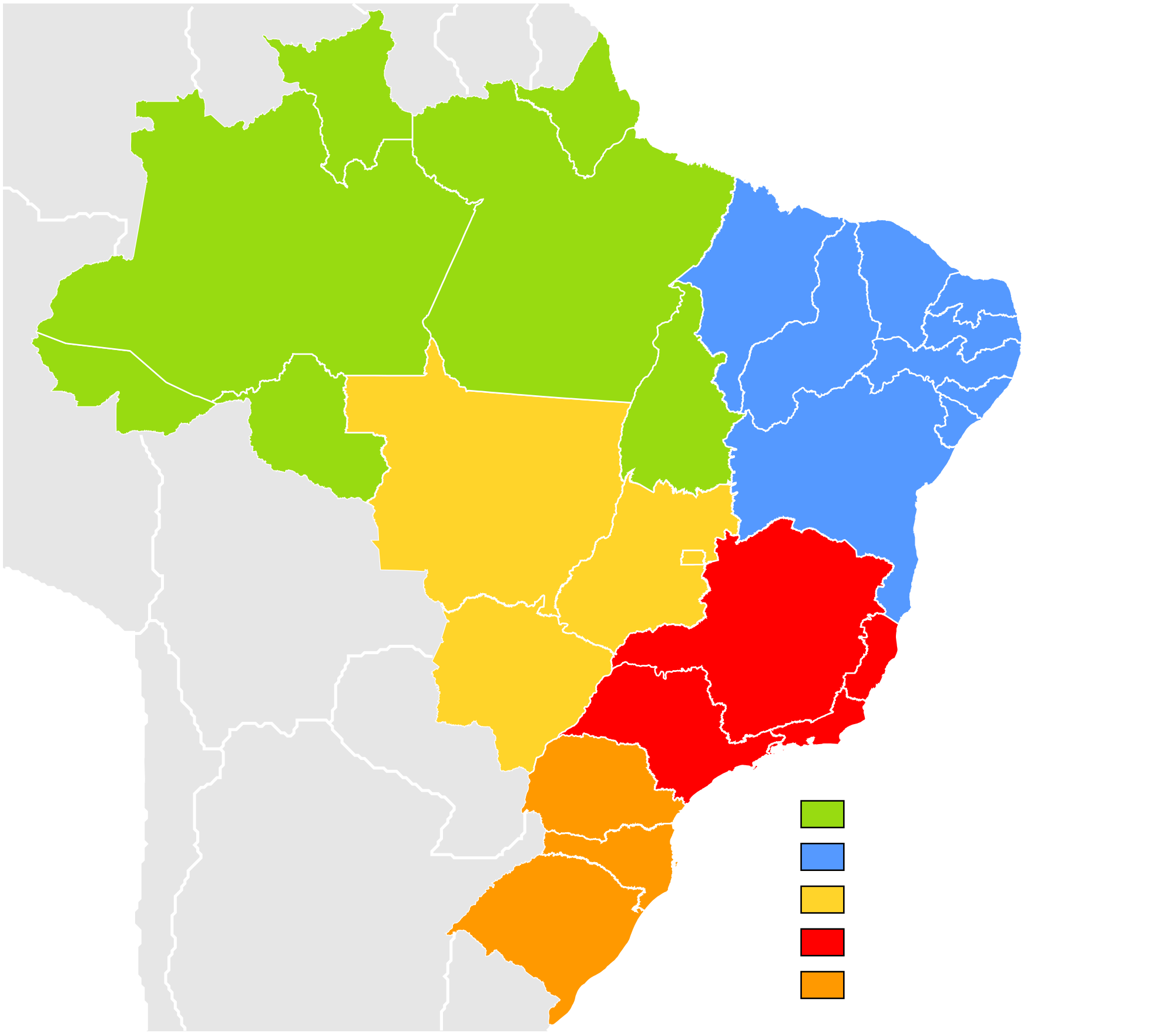
Regions of Brazil
View on Wikipedia
This article needs additional citations for verification. (August 2010) |

Brazil is geopolitically divided into five regions (also called macroregions), by the Brazilian Institute of Geography and Statistics, which are formed by the federative units of Brazil. Although officially recognized, the division is merely academic, considering geographic, social and economic factors, among others, and has no political effects other than orientating Federal-level government programs.[1] Under the state level, they are further divided into intermediate regions and even further into immediate regions.[2]
The five regions
[edit]Name |
Area (km2) | Area (%) | Population (2022 census) |
Population density (per km2) |
Population (%) | Most populous municipality |
Largest metropolitan area |
Number of federative units |
|---|---|---|---|---|---|---|---|---|
| Central-West | 1,612,007.2 | 18.86 | 16.2 million | 10.05 | 8.02 | Brasília | Brasília Integrated Development Region | 4 |
| Southeast | 927,286 | 10.85 | 84.8 million | 91.44 | 41.8 | São Paulo | São Paulo metropolitan area | 4 |
| South | 577,214 | 6.75 | 29.9 million | 51.83 | 14.7 | Porto Alegre | Porto Alegre metropolitan area | 3 |
| Northeast | 1,558,196 | 18.29 | 54.6 million | 35.04 | 26.9 | Fortaleza | Recife metropolitan area | 9 |
| North | 3,689,637.9 | 45.27 | 17.3 million | 4.69 | 8.5 | Manaus | Manaus metropolitan area | 7 |
Central-West Region
[edit]
- Area: 1,612,007.2 km2 (18.86%)
- Population: 16,289,538 (7.2 people/km2; 6.4%)
- GDP: R$279 billion / US$174,3 billion (2008; 8.3%) (4th)
- Climate: Savanna climate (hot, with little precipitation during winter in the northeast and the east; Tropical in the east and in the west; Equatorial in the north; Some temperate climate places in the south).
- States: Goiás, Mato Grosso, Mato Grosso do Sul, Distrito Federal (Federal District).
- Largest Cities: Brasília (national capital) (2,562,963); Goiânia (1,318,148); Campo Grande (796,252); Cuiabá (556,298); Aparecida de Goiânia (442,978); Anápolis (334,613).
- Economy: Livestock,[3] Soybeans, Maize, Sugarcane, Cotton, Tomato,[4][5] Nickel, Copper, Gold,[6] tourism.[7][8][9]
- Transport: Highways where they are present (mostly in the center and east regions); transport by rivers is common in the north and in the east; airplanes are used in remote and smaller communities.
- Vegetation: Mainly savanna-like vegetation, including the Pantanal (Chaco, in Paraguay), flooded areas in the west, equatorial rainforests in the north.
- Notable characteristics: With a low population density, most of the land in the region is used for grazing instead of agriculture. The region is also the least industrialized in the country, based mainly in food & meat processing.
Southeast Region
[edit]
- Area: 927,286 km2 (10.85%)
- Population: 84,840,113 (77.96 people/km2, 38%)
- GDP: R$1,629 trillion / US$803 billion (2008; ~49%) (1st)
- Climate: Tropical in the northwest (warm, relatively dry in the winter and wet in the summer); Semi-arid in the north; temperate in the south
- States: Espírito Santo, Minas Gerais, Rio de Janeiro, São Paulo
- Largest cities: São Paulo (11,037,593); Rio de Janeiro (6,186,710); Belo Horizonte (2,452,617); Guarulhos (1,299,283); Campinas (1,064,669); São Gonçalo (991,382); Duque de Caxias (872,762); Nova Iguaçu (865,089); São Bernardo do Campo (810,979); Osasco (718,646); Santo André (673,396); Uberlândia (634,345); Contagem (625,393); São José dos Campos (615,871); Sorocaba (584,313); Ribeirão Preto (563,107); Juiz de Fora (526,706); Belford Roxo (501,544); Niterói (479,384); São João de Meriti (469,827); Betim (441,748); Campos dos Goytacazes (434,008).
- Economy: Manufacturing (machinery, electronics, automobiles and aviation, steel, chemicals, shoes, textiles),[8] coffee, sugar cane, orange juice,[10][5][4] livestock,[3] tourism,[7] petroleum,[11][12] iron, gold,[6] energy production (not sufficient, however, to fulfill its demand).[13][9] The Southeast is the economic center of Brazil, and most large companies present in Brazil have their headquarters in this region. The economic success of this region is a combination of its 4 states. São Paulo state is the most developed in the country, it has a population density as high as western Europe, and a HDI [1] comparable to eastern Europe. Rio de Janeiro is the leader in petroleum production (with almost 3/4 of national production) [2]. Minas Gerais and Espírito Santo are located in the richest mining region in Brazil.
- Transport: The region is heavily covered by highways, and, to some extent, railways. Railways and rivers are used mainly for freight, and used where they are present. The region also contains several airport hubs which provide many domestic and international air routes.
- Vegetation: Mainly tropical-like semi-deciduous forests (Mata Atlântica); semi-arid in the north, with almost no vegetation; savannah-like vegetation in the west and in the northwest (Cerrado). Very little of the native vegetation still remains (~2%, mostly in parks.)
- Notable characteristics: The southeast region is the major powerhouse of the Brazilian economy, responsible for 49% of the Brazilian GDP (approximately US$1024 billion in 2010). It is also the most populous region in the country, with more than 80 million people, and contains the three most important metropolitan regions (São Paulo, Rio de Janeiro and Belo Horizonte), as well as many other large cities (such as, Vitória (the capital of Espírito Santo state), Campinas, Uberlândia and several others.)
South Region
[edit]
- Area: 577,214 km2 (6.75%)
- Population: 29.937.706 (43.46 people/km2, 12.5%)
- GDP: R$503 billion / US$313,8 billion (2008; ~15%) (2nd)
- Climate: Subtropical by the coast, hot to moderately hot in the summer, mild and very humid winters and temperate by the mountain range, the valleys and the plateaus in the interior, with moderate temperatures in the summer and cold in the winter, with well distributed rainfalls. Snow is relatively common, mainly in the highlands (for example in Santa Catarina state's São Joaquim).
- States: Paraná, Rio Grande do Sul, Santa Catarina
- Largest Cities:[14] Curitiba (1,764,540); Porto Alegre (1,413,094); Joinville (520,905); Londrina (511,278); Caxias do Sul (441,332); Florianópolis (427,298); Maringá (362,329); Pelotas (328,864); Canoas (325,188); Ponta Grossa (314,527); Blumenau (312,634); Cascavel (289,339); Foz do Iguaçu (255,900); and Santa Maria (262,368).
- Economy: Machinery and automobile industries, textiles, shoes, information technology[8]tourism,[7] soy, maize, wheat, tobacco, rice, apple,[5][4] wine,[15]livestock,[3] coal,[16][17][6] energy production.[9][18]
- Transport: There are many developed highways and railways throughout the region, although the latter is mainly used for freight. Rivers are used when possible.
- Vegetation: Rainforests along the coast (Mata Atlântica), subtropical semiciduous in the north and west (Araucárias) and prairie-like vegetation in the south (Pampas). Little native vegetation still remains due to deforestation.
- Notable characteristics: The South Region of Brazil is historically characterized by its high standard of living, with considerably better social indicators, which include some of the cities with the highest HDI levels in the country, including their capitals. Cities also feature an advanced level of urbanism in comparison with other parts of Brazil. The region is almost the newest in terms of urbanization, it was recently populated by European immigrants (almost 19th century immigration and refugees of World War I and World War IIs). They have added to the local culture, especially in architecture, cuisine and forms of agriculture. Southern region, however, is not immune from poverty, violence and other social issues, especially in the larger cities, even though in a lower level than poorer areas in the country. The state of Santa Catarina is proportionally the Whitest state in Brazil with over 87% of its population being European. The other southern states also have the highest percentage rates of European population.
Northeast Region
[edit]
- Area: 1,561,177 km2 (18.3%)
- Population: 54,658,515 (30.55 people/km2; 29%; 2009)
- GDP: R$437 billion / US$273,1 billion (2009; ~12%) (3rd)
- Climate: Hot all year long. Tropical near the coast and semi-arid in the interior; semi-equatorial in the far west of the region.
- States: Alagoas, Bahia, Ceará, Maranhão, Paraíba, Pernambuco, Piauí, Rio Grande do Norte, Sergipe
- Largest cities: Salvador (2,676,606); Fortaleza (2,447,409); Recife (1,536,934); São Luís (1,011,943); Maceió (932,608); Natal (789,836); Teresina (714,583); João Pessoa (595,429); Jaboatão dos Guararapes; (580,795); Feira de Santana (481,137); Aracaju (461,083); Olinda (368,666); Campina Grande (354,546).
- Economy: Tourism,[7] tropical fruits (coconut, papaya, melon, banana, mango, pineapple), cocoa, cashew nuts, soybeans, cotton, sugarcane,[19][4][20][5] machinery manufacturing, textiles,[8]wind energy production,[9][21] salt extraction.[22][6]
- Transport: Mainly highways, which are more abundant along the coast, although transport by sea is also important.
- Vegetation: Mainly desert-like vegetation, with tropical forests along the coast and in the west and savanna-like vegetation in the southwest.
- Notable characteristics: This region was the first part of Brazil discovered by the Portuguese, and the first Brazilian capital, Salvador, was founded here. It has the lowest levels in the country in almost all of the social indicators, being considered the most impoverished region in Brazil. However, it has been growing above national average since the start of the 21st century, gradually reducing the socio-economic distance to the other regions.
North Region
[edit]
- Area: 3,689,637.9 km2 (45.27%)
- Population: 17,354,884 (4,5 people/km2; 6.2%; 2016)
- GDP: R$ 308 billion / US$94,8 billion (2016; 4.7%) (5th)
- Climate: Equatorial
- States: Acre, Amapá, Amazonas, Pará, Rondônia, Roraima, Tocantins
- Largest Cities: Manaus (2,063,689); Belém (1,303,403); Ananindeua (478,778); Porto Velho (460,434); Macapá (442,933); Boa Vista (413,486); Rio Branco (364,756); Santarém (331,937); Palmas (302,692).
- Economy: Iron, Copper, Gold, Bauxite, Manganese,[6] Açaí, Pineapple,[23][24][25][5] Energy production,[26][27][9] electronic manufacturing,[28][8] tourism.[7][3]
- Transport: Mainly rivers (which are abundant in the region). Highways are scarce and present mainly in the east. Airplanes are commonly used in small remote communities and sometimes in the larger cities.
- Vegetation: Almost the entire region is covered by Amazon rainforest, except the state of Tocantins, which has savanna-like vegetation (cerrado). Most of the native vegetation still remains.
- Notable characteristics: Presence of the Amazon Rainforest, which is the vegetation dominant in every state but Tocantins. Cities are spread far apart in the region, and it has the lowest population density of the country. There are very few paved highways in the region, as it is almost isolated from the rest of the country. It is also the biggest region of Brazil, being responsible for almost half of the Brazilian territorial extension. Economic growth is above national average (especially in Amazonas and in Tocantins).
Ethnic composition of regions
[edit]The composition of regions of Brazil according to autosomal genetic studies focused on the Brazilian population (which has been found to be a complex melting pot of European, African and Native Americans components):
A 2011 autosomal DNA study, with nearly 1000 samples from all over the country ("whites", "pardos" and "blacks"), found a major European contribution, followed by a high African contribution and an important Native American component.[29] The study showed that Brazilians from different regions are more homogeneous than previously thought by some based on the census alone. "Brazilian homogeneity is, therefore, a lot greater between Brazilian regions than within Brazilian regions."[30]
| Region[29] | European | African | Native American |
|---|---|---|---|
| Southeast Brazil | 74.20% | 17.30% | 7.30% |
| Southern Brazil | 79.50% | 10.30% | 9.40% |
| Northeast Brazil | 60.10% | 29.30% | 8.90% |
| Northern Brazil | 68.80% | 10.50% | 18.50% |
According to an autosomal DNA study from 2010, a new portrayal of each ethnicity contribution to the DNA of Brazilians, obtained with samples from the five regions of the country, has indicated that, on average, European ancestors are responsible for nearly 80% of the genetic heritage of the population. The variation between the regions is small, with the possible exception of the South, where the European contribution reaches nearly 90%. The results, published by the scientific American Journal of Human Biology by a team of the Catholic University of Brasília, show that, in Brazil, physical indicators such as colour of skin, eyes and hair have little to do with the genetic ancestry of each person, which has been shown in previous studies (regardless of census classification).[31] Ancestry informative SNPs can be useful to estimate individual and population biogeographical ancestry. Brazilian population is characterized by a genetic background of three parental populations (European, African, and Brazilian Native Amerindians) with a wide degree and diverse patterns of admixture. In this work we analyzed the information content of 28 ancestry-informative SNPs into multiplexed panels using three parental population sources (African, Amerindian, and European) to infer the genetic admixture in an urban sample of the five Brazilian geopolitical regions. The SNPs assigned apart the parental populations from each other and thus can be applied for ancestry estimation in a three hybrid admixed population. Data was used to infer genetic ancestry in Brazilians with an admixture model. Pairwise estimates of F(st) among the five Brazilian geopolitical regions suggested little genetic differentiation only between the South and the remaining regions. Estimates of ancestry results are consistent with the heterogeneous genetic profile of Brazilian population, with a major contribution of European ancestry (0.771) followed by African (0.143) and Amerindian contributions (0.085). The described multiplexed SNP panels can be useful tool for bioanthropological studies but it can be mainly valuable to control for spurious results in genetic association studies in admixed populations."[32]
| Region[32] | European | African | Native American |
|---|---|---|---|
| Central-West Brazil | 65.90% | 18.70% | 11.80% |
| Southeast Brazil | 79.90% | 14.10% | 6.10% |
| South Brazil | 87.70% | 7.70% | 5.20% |
| Northeast Brazil | 77.40% | 13.60% | 8.90% |
| North Brazil | 71.10% | 18.20% | 10.70% |
An autosomal DNA study from 2009 found a similar profile "all the Brazilian samples (regions) lie more closely to the European group than to the African populations or to the Mestizos from Mexico."[33]
| Region[33] | European | African | Native American |
|---|---|---|---|
| Central-West Brazil | 66.3% | 21.7% | 12.0% |
| Southeast Brazil | 60.7% | 32.0% | 7.3% |
| South Brazil | 81.5% | 9.3% | 9.2% |
| Northeast Brazil | 66.7% | 23.3% | 10.0% |
| North Brazil | 60.6% | 21.3% | 18.1% |
According to another autosomal DNA study from 2008, by the University of Brasília (UnB), European ancestry dominates in the whole of Brazil (in all regions), accounting for 65.90% of heritage of the population, followed by the African contribution (24.80%) and the Native American (9.3%); the European ancestry being the dominant ancestry in all regions including the Northeast of Brazil.[34]
A study from 1965, "Methods of Analysis of a Hybrid Population" (Human Biology, vol 37, number 1), led by geneticists D. F. Roberts and R. W. Hiorns, found out the average Northeastern Brazilian to be predominantly European in ancestry (65%), with minor but important African and Native American contributions (25% and 9%).[35]
See also
[edit]Notes
[edit]- The number given in parentheses are percentages relative to Brazil as a whole.
- The populations for the cities given do not include their metropolitan areas.
References
[edit]- ^ The Five Regions Of Brazil, from worldatlas.com
- ^ Costa, Guilherme S.; Cota, Wesley; Ferreira, Silvio C. (2020-05-13). "Metapopulation modeling of COVID-19 advancing into the countryside: an analysis of mitigation strategies for Brazil". medRxiv 10.1101/2020.05.06.20093492v2.
- ^ a b c d PPM 2017: Bovine herd predominates in the Midwest and Mato Grosso leads among the states
- ^ a b c d IBGE prevê safra recorde de grãos em 2020
- ^ a b c d e Brazil's Agriculture by FAO
- ^ a b c d e Brazilian Mineral Yearbook
- ^ a b c d e Statistical Yearbook for Tourism 2020 base year 2019, page 331 of the PDF file (in Portuguese)
- ^ a b c d e Industry in Brazil
- ^ a b c d e RENEWABLE CAPACITY STATISTICS 2021
- ^ Agriculture in Southeast Region of Brazil
- ^ "Composição do PIB do estado do Rio de Janeiro". Archived from the original on 2020-06-14. Retrieved 2022-04-10.
- ^ "Rio aumenta sua participação na produção nacional de petróleo e gás". Archived from the original on 27 October 2020. Retrieved 20 July 2020.
- ^ "O BNDES e a questão energética e logística da Região Sudeste" (PDF).
- ^ "IBGE | Portal do IBGE | IBGE" (PDF). Archived from the original (PDF) on 2011-10-07. Retrieved 2011-08-31.
- ^ Além da serra gaúcha: conheça outras regiões produtoras de vinho pelo Estado
- ^ Carvão Mineral
- ^ Carvão mineral no Brasil e no mundo
- ^ Itaipu site
- ^ A AGRICULTURA NO NORDESTE BRASILEIRO: OPORTUNIDADES E LIMITAÇÕES AO DESENVOLVIMENTO
- ^ PPM 2017: Bovine herds predominate in the Midwest and Mato Grosso leads among the states
- ^ Região Nordeste bate recorde na geração de energia eólica e solar
- ^ A economia salineira no Rio Grande do Norte
- ^ Paths of açaí: Pará produces 95 % of Brazil's production, fruit moves US $ 1.5 billion and São Paulo is the main destination in the country
- ^ "Abacaxi faz o Pará despontar como o maior produtor nacional do fruto". Archived from the original on 2020-07-15. Retrieved 2022-04-10.
- ^ Brazilian Pineapple production
- ^ Belo Monte, a maior hidrelétrica do Brasil, inaugura sua capacidade total de geração de energia
- ^ Royalties da UHE Tucuruí chegam a R$ 156,2 milhões em 2021
- ^ Zona Franca de Manaus: por que mesmo gerando r$ 158 bilhões em receita e mais de 100 mil empregos muitos ainda criticam sua existência
- ^ a b Pena, Sérgio D. J.; Di Pietro, Giuliano; Fuchshuber-Moraes, Mateus; Genro, Julia Pasqualini; Hutz, Mara H.; Kehdy, Fernanda de Souza Gomes; Kohlrausch, Fabiana; Magno, Luiz Alexandre Viana; Montenegro, Raquel Carvalho; Moraes, Manoel Odorico; de Moraes, Maria Elisabete Amaral; de Moraes, Milene Raiol; Ojopi, Élida B.; Perini, Jamila A.; Racciopi, Clarice; Ribeiro-dos-Santos, Ândrea Kely Campos; Rios-Santos, Fabrício; Romano-Silva, Marco A.; Sortica, Vinicius A.; Suarez-Kurtz, Guilherme (2011). Harpending, Henry (ed.). "The Genomic Ancestry of Individuals from Different Geographical Regions of Brazil is More Uniform Than Expected". PLoS ONE. 6 (2) e17063. Bibcode:2011PLoSO...617063P. doi:10.1371/journal.pone.0017063. PMC 3040205. PMID 21359226.
- ^ Nossa herança europeia — Archived 2012-01-30 at the Wayback Machine
- ^ DNA de brasileiro é 80% europeu, indica estudo
- ^ a b Lins, T. C.; Vieira, R. G.; Abreu, B. S.; Grattapaglia, D.; Pereira, R. W. (March–April 2009). "Genetic composition of Brazilian population samples based on a set of twenty-eight ancestry informative SNPs". American Journal of Human Biology. 22 (2): 187–192. doi:10.1002/ajhb.20976. PMID 19639555. S2CID 205301927.
- ^ a b Forensic Science International: Genetics. Allele frequencies of 15 STRs in a representative sample of the Brazilian population (inglés) Archived 2011-04-08 at WebCite basandos en estudios del IBGE de 2008. Se presentaron muestras de 12.886 individuos de distintas etnias, por regiones, provenían en un 8,26% del Norte, 23,86% del Nordeste, 4,79% del Centro-Oeste, 10,32% del Sudeste y 52,77% del Sur.
- ^ Untitled Document Archived 2011-07-06 at the Wayback Machine
- ^ BVGF - A Obra / OpЩsculos Archived 2012-03-31 at the Wayback Machine
Regions of Brazil
View on GrokipediaHistorical Development
Colonial Settlement and Early Divisions
The Portuguese explorer Pedro Álvares Cabral landed on the Brazilian coast on April 22, 1500, initiating colonization focused primarily on the littoral zones suitable for export-oriented agriculture.[6] By the mid-16th century, the Northeast emerged as the economic core, with large-scale sugar plantations (engenhos) established in regions like Pernambuco and Bahia, relying on enslaved African labor imported via the transatlantic trade; Brazil received approximately 4.9 million African slaves overall, the majority funneled to these coastal estates where mortality rates exceeded 10% annually due to grueling conditions.[7][8] This plantation system, which dominated from the 1540s onward, created a stark geographic divide, concentrating population and wealth along the humid Atlantic seaboard while leaving interior areas largely unexplored.[9] In contrast, the Southeast saw dynamic inland expansion driven by bandeirantes—semi-autonomous expeditions originating from São Paulo—who ventured westward from the late 16th century, initially capturing indigenous slaves but shifting to prospecting after gold discoveries in the 1690s.[10] The 18th-century gold rush in Minas Gerais yielded over 1,200 tonnes extracted through artisanal methods, drawing migrants from coastal areas and fostering urban centers like Ouro Preto, which by 1720 housed tens of thousands; this mineral wealth temporarily eclipsed sugar exports, redirecting capital and labor southward and inland, with half of Brazil's population residing in the Southeast by the 1720s.[11] Such expeditions entrenched economic specialization, as mineral rents funded infrastructure but also perpetuated boom-bust cycles tied to depleting veins. Settlement in the North, encompassing the Amazon basin, remained sparse and extractive-focused during the colonial era, limited by dense forests, indigenous resistance, and logistical challenges; Portuguese efforts centered on riverine outposts and Jesuit missions established from the 17th century, yielding modest outputs in drugs like sarsaparilla rather than large-scale agriculture or mining.[12] By the late 18th century, the region's population hovered below 100,000, contrasting sharply with denser southern captaincies, as crown policies prioritized containment over penetration to avoid overextension.[12] Following independence in 1822, the South—regions like Rio Grande do Sul and Santa Catarina—experienced targeted European immigration waves, with over 20,000 Germans arriving by 1850 to establish smallholder farms growing wheat, tobacco, and yerba mate, supplanting ranching traditions and introducing diversified agriculture suited to temperate climates.[13] Subsequent influxes of Italians and Poles in the 1870s onward reinforced this pattern, as provincial governments subsidized settlements to populate frontiers and reduce reliance on slave labor, laying foundations for ethnic enclaves with distinct cultural and productive profiles divergent from the Afro-indigenous mixes of the Northeast or mineral-dependent Southeast.[14] These migrations, peaking at 3.5 million Europeans by 1920, crystallized early regional identities through labor-intensive agrarian economies insulated from tropical staples.[14]Republican Period and Official Regionalization
The proclamation of the Brazilian Republic on November 15, 1889, marked a shift toward federalism under the 1891 Constitution, granting significant autonomy to the states while maintaining a centralized executive, though this structure reinforced regional oligarchic control, particularly by elites in Minas Gerais and São Paulo.[15] Early republican governance, known as the "Política dos Governadores," prioritized state-level alliances over macro-regional coordination, yet national censuses initiated in 1872 began revealing persistent spatial income disparities across provinces that would evolve into modern states, with southeastern areas showing higher per capita wealth compared to the impoverished Northeast.[16] These demographic enumerations, continued in 1890 and 1900, highlighted uneven population distribution and economic output, fostering initial awareness of imbalances beyond state borders, such as the concentration of agricultural exports in the Southeast versus subsistence farming in the North and Northeast.[17] In the early 20th century, internal migrations intensified these disparities, driven by environmental crises and economic booms; severe droughts in the Northeast from 1915 onward, culminating in the 1915–1919 and 1932 events, displaced hundreds of thousands, prompting government responses like refugee camps and migration to urban centers in the Southeast.[18] Concurrently, the Southeast experienced a coffee export surge, with production peaking in the 1920s and accounting for over 70% of Brazil's export value by the decade's end, fueling infrastructure like railroads and attracting European immigrants, which widened the developmental gap with drought-prone regions.[19] These dynamics underscored macro-regional patterns, as northeastern agricultural failures contrasted with southeastern valorization of coffee lands, leading to policy discussions on inter-regional resource transfers amid federalist constraints.[20] Under Getúlio Vargas's provisional government from 1930 to 1945, and his elected term from 1951 to 1954, centralized planning addressed these imbalances through state-led industrialization and infrastructure initiatives, laying analytical foundations for regional development without formal divisions.[21] Vargas's administration promoted import-substitution policies that boosted manufacturing in the Southeast while initiating drought mitigation in the Northeast via projects like the 1930s Fome Zero precursors and hydraulic works, reflecting empirical recognition of climatic and economic divides.[22] Efforts to expand frontiers in the Central-West, including road-building and land surveys in the 1940s–1950s, aimed to alleviate coastal overcrowding and integrate underpopulated interiors, with population in Goiás and Mato Grosso states growing from under 1 million in 1940 to over 2 million by 1960 through subsidized settlement.[23] This era's focus on causal factors like resource endowments and federal investments prefigured unified regional frameworks, prioritizing data-driven interventions over purely political federalism.[24]Purpose and Framework
Establishment by IBGE in 1970
The Brazilian Institute of Geography and Statistics (IBGE) formalized the division of Brazil into five macro-regions—North, Northeast, Central-West, Southeast, and South—through Decree No. 67.647, issued on November 23, 1970, and published in the Official Gazette of the Republic on December 4, 1970.[1] This framework emerged from internal IBGE deliberations in the late 1960s, building on the expanded data collection enabled by the 1960 national census, which first enumerated all municipalities and highlighted the need for standardized regional aggregation to facilitate statistical analysis and comparability across diverse territories.[25] The decree defined the regions by grouping contiguous states and the Federal District based on shared geographic, economic, and infrastructural characteristics, without modifying any existing state or municipal boundaries.[26] This establishment aligned with the developmentalist priorities of Brazil's military government (1964–1985), which sought to mitigate regional disparities in growth and infrastructure through centralized planning and targeted public investments.[27] IBGE's regional schema provided a tool for aggregating census and economic data to inform policies like resource allocation for agriculture, industry, and transportation, addressing imbalances where southern and southeastern areas concentrated industrial output while northern and northeastern regions lagged in per capita income and urbanization rates as of the 1970 census.[25] Unlike prior informal or physiographic divisions dating to the 1940s, the 1970 system emphasized socioeconomic criteria for policy relevance, enabling the government to monitor development indicators at a macro scale without the fragmentation of state-level data alone.[28] The framework encompassed all 22 states, federal territories (such as those later becoming states like Rondônia and Tocantins), and the Federal District at the time, ensuring comprehensive national coverage for analytical purposes only, with no legal or administrative implications for governance or fiscal transfers.[26] This purely statistical orientation allowed IBGE to produce unified datasets for variables like population density, GDP contributions, and migration flows, supporting evidence-based decisions amid rapid post-1960s urbanization and the expansion of federal planning agencies.[25] Subsequent adjustments, such as the 1990 reclassification of intermediate regions, preserved the core five-region structure, underscoring its enduring role in Brazilian territorial statistics.[27]Criteria, Scope, and Alternative Classifications
The Brazilian Institute of Geography and Statistics (IBGE) delineates the five regions through groupings of contiguous states that exhibit shared physiographic features—such as river basins, biomes, and relief patterns—and analogous developmental trajectories influenced by these environmental factors, rather than delineations rooted in ethnic compositions or cultural identities.[29] For instance, the North Region coalesces states within the Amazon basin's hydrological and ecological domain, facilitating statistical aggregation for planning predicated on natural causal drivers like precipitation regimes and soil types.[1] This approach prioritizes empirical geographic realities over administrative convenience alone, enabling analysis of phenomena like infrastructure viability tied to terrain accessibility. The framework's scope is confined to the continental territory of Brazil, spanning 8,515,767 square kilometers and incorporating all 26 states plus the Federal District, with no inclusion of extraterritorial holdings akin to those maintained by other federations. Population distribution reveals stark disparities driven by historical settlement patterns and resource availability, with the Southeast Region achieving densities exceeding 80 inhabitants per square kilometer as of 2022 census data, contrasted against the North's under 4 per square kilometer, underscoring how physiographic barriers like dense rainforests constrain demographic concentration.[4] Alternative classifications emerge for policy domains requiring finer-grained or biome-centric interventions, revealing the five-region model's constraints in capturing sub-regional heterogeneities. The Legal Amazon (Amazônia Legal), formalized by Federal Law No. 1,793 in 1953, aggregates territory across nine states—including Maranhão's western exclave and parts of Tocantins—for Amazon-specific incentives like fiscal exemptions and infrastructure to counter deforestation pressures and spur integration, covering 61% of national territory but diverging from IBGE boundaries by prioritizing ecological continuity over state contiguity. Similarly, the Drought Polygon (Polígono das Secas) in the Northeast, mapped since the 1950s by the National Water Agency for arid-zone targeting, delineates chronic low-precipitation areas spanning multiple states to direct irrigation and relief, illustrating how climatic causal factors necessitate overlays beyond broad regional schemas for effective resource allocation. These variants, while not supplanting IBGE's statistical utility, expose gaps in addressing localized environmental determinism, such as biome transitions or hydrological variances unaligned with state lines.The Five Regions
North Region
The North Region of Brazil consists of seven states: Acre, Amapá, Amazonas, Pará, Rondônia, Roraima, and Tocantins. This region spans approximately 3,689,638 square kilometers, accounting for 45.27% of the country's total territory, yet it is home to only about 5% of Brazil's population, roughly 18 million residents as of 2022 estimates derived from census trends.[30] [31] The area is dominated by the Amazon rainforest, featuring a tropical climate with high temperatures averaging 25–28°C year-round, heavy annual rainfall exceeding 2,000 mm in many areas, and an extensive network of rivers including the Amazon, which discharges more water than the next seven largest rivers combined. These waterways support unparalleled biodiversity, with the region hosting millions of insect species, thousands of fish, and significant populations of mammals, birds, and reptiles, positioning it as a global hotspot for endemism.[32] Ecological pressures in the North Region are acute, particularly deforestation, which has resulted in nearly 20% loss of the Brazilian Amazon's forest cover since the 1970s, according to satellite monitoring by Brazil's National Institute for Space Research (INPE).[33] This degradation stems primarily from agricultural expansion, cattle ranching, and illegal logging, exacerbating soil erosion, biodiversity decline, and altered regional hydrology. Indigenous territories, covering substantial portions of the region, face ongoing encroachments that fuel land disputes, with conflicts often involving miners, loggers, and farmers seeking resource access amid weak enforcement of demarcation laws.[34] [35] Economically, the North Region contributes around 5% to Brazil's GDP, driven by extractive industries such as mining (notably iron ore, bauxite, and gold in states like Pará and Amapá), timber harvesting, and burgeoning agriculture including soy cultivation and livestock. However, GDP per capita remains among the lowest nationally, hampered by rudimentary infrastructure like limited road networks prone to flooding and isolation from major markets, which inflate logistics costs and deter investment.[36] [37] These factors perpetuate underdevelopment despite abundant natural resources, with governance challenges including corruption in resource concessions compounding inefficiencies.[38]Northeast Region
The Northeast Region encompasses nine states: Alagoas, Bahia, Ceará, Maranhão, Paraíba, Pernambuco, Piauí, Rio Grande do Norte, and Sergipe. It spans 1,561,177 km², constituting 18% of Brazil's land area, and houses approximately 57 million residents, accounting for 27% of the national population according to 2022 census data.[5] Geographically, the region contrasts fertile coastal plains suitable for agriculture with a vast semi-arid interior characterized by the Caatinga biome, where irregular rainfall patterns frequently lead to prolonged droughts that undermine crop yields and pastoral activities.[39] The economy originated in colonial-era monocultures of sugar cane and cotton, reliant on enslaved African labor and expansive latifundia estates that entrenched land concentration and dependency structures persisting post-abolition. These historical patterns, exacerbated by climatic unreliability, have sustained elevated poverty rates and a regional Human Development Index below the 2023 national average of 0.786, with agriculture remaining vulnerable to events like the 2012–2017 drought crisis that caused widespread livestock mortality and reduced grain production by up to 50% in affected sertão areas.[40] Modern diversification includes tourism in coastal enclaves and remittances from out-migrants, yet the sector contributes roughly 12% to national GDP while grappling with inequality driven by environmental constraints rather than resource scarcity.[41] Demographically, the population exhibits high proportions of African-descended individuals, with 2022 census figures indicating 59.6% multiracial (pardo), 13% Black (preto), and 26.7% White, reflecting legacies of the Atlantic slave trade concentrated in plantation zones like Bahia. Cultural centers such as Salvador preserve Afro-Brazilian traditions, including candomblé and capoeira, amid social challenges like informal settlements (favelas) in urban peripheries. Urbanization lags behind southern regions, with only about 75% urban dwellers versus the national 87%, as rural-to-urban shifts are slowed by agricultural disruptions and limited industrial base in drought-vulnerable hinterlands.[5]Central-West Region
The Central-West Region comprises the states of Goiás, Mato Grosso, Mato Grosso do Sul, and the Federal District, encompassing 1,606,371 square kilometers, or approximately 19% of Brazil's territory.[42] As of 2022, the region hosted 16.3 million inhabitants, representing 8% of the national population.[43] Dominated by the Cerrado biome, a savanna characterized by wooded grasslands, shrubs, and distinct wet and dry seasons, the region features a tropical climate with average annual temperatures around 23°C and rainfall concentrated from October to April.[44] This landscape has facilitated agricultural expansion, though it includes significant indigenous reserves covering portions of the land, with national indigenous territories accounting for about 14% of Brazil's area, many concentrated in central areas.[45] The economy centers on agribusiness, with soybeans, beef cattle, and maize as primary outputs, driving regional GDP growth that outpaced the national average by a factor of three in recent years.[46] Soybean cultivation, in particular, expanded rapidly in Mato Grosso during the 1990s and 2000s through mechanized farming on converted pastures and native vegetation, enabled by improved seeds, machinery, and infrastructure like highways.[47] Beef production benefits from extensive ranching, while biofuels derive from soy and sugarcane byproducts, contributing to export revenues exceeding national agricultural benchmarks in volume.[48] This frontier development has boosted formal employment by 6.8% in the early 2020s, though it exacerbates urban-rural divides, with rural mechanization contrasting sparse population densities outside Brasília.[46] Brasília, the national capital within the Federal District, serves as the administrative hub, housing federal government institutions and fostering service-sector activity amid the region's agrarian focus.[49] Environmental impacts include accelerated Cerrado deforestation, which rose 43% in 2023 to record levels, primarily for cropland conversion, releasing stored carbon from deep-rooted vegetation and altering local hydrology.[50] Indigenous lands in the region, where over 97% of residents in such territories identify as indigenous, face encroachment pressures from agricultural advances, highlighting tensions between economic gains and habitat preservation.[51]Southeast Region
The Southeast Region of Brazil consists of the states of São Paulo, Rio de Janeiro, Minas Gerais, and Espírito Santo. This region spans approximately 925,000 km², accounting for about 11% of the country's total land area. As of July 1, 2024, it is home to 88,617,693 inhabitants, representing roughly 42% of Brazil's population of 212.6 million. The climate varies from tropical in coastal areas of Rio de Janeiro and Espírito Santo to subtropical in the elevated plateaus of São Paulo and parts of Minas Gerais.[52] [53] [54] Historically, the region's economic foundations were laid by the 18th-century gold rush in Minas Gerais, which began around 1693 and fueled colonial wealth accumulation until mine exhaustion in the early 19th century. This transitioned into the 19th-century coffee boom, particularly in the Paraiba Valley of Rio de Janeiro and western São Paulo from the 1820s onward, where coffee exports comprised over 40% of Brazil's total by the 1840s, generating capital for infrastructure and early industrialization. These resource-driven cycles enabled reinvestment into manufacturing and urban development, distinguishing the Southeast's path from less capitalized regions.[55] [56] Today, the Southeast drives Brazil's economy through advanced manufacturing, financial services, and commerce, with São Paulo serving as a major global city and financial center. It exhibits the highest urbanization rate in the country at 94.44% according to the 2022 census, supported by extensive infrastructure networks like highways and ports. However, rapid population influx from internal migrations starting in the 1950s has led to unmanaged urban expansion, manifesting in informal settlements known as favelas and higher crime rates in metropolitan areas such as Rio de Janeiro and São Paulo.[57]South Region
The South Region of Brazil comprises three states: Paraná, Santa Catarina, and Rio Grande do Sul, covering approximately 576,410 square kilometers, or 6.8% of the national territory. As of 2022, the region had a population of about 30.5 million, representing 14.3% of Brazil's total inhabitants, with urban centers like Porto Alegre (1.4 million) and Curitiba (1.9 million) driving density. The climate is subtropical to temperate, featuring cooler winters with occasional frosts in the highlands and pampas grasslands of Rio Grande do Sul, contrasting with Brazil's predominantly tropical zones; average annual temperatures range from 17–22°C, supporting distinct agricultural patterns. Economically, the South excels in agro-industry, contributing around 17% to Brazil's GDP in 2022 through diversified outputs like soybean production (Paraná led national yields with 20 million tons in 2023), wheat, rice, and livestock processing, alongside wine production in the Serra Gaúcha (Rio Grande do Sul accounts for 90% of national wine). Manufacturing, including automobiles in Paraná and textiles in Santa Catarina, bolsters exports; the region's HDI averaged 0.777 in 2010 (latest comprehensive state data), above the national 0.755, linked to higher education attainment (mean schooling years: 8.5 vs. national 7.7) and European immigrant investments in infrastructure since the late 19th century. Lower poverty rates (around 15% in 2022 vs. national 25%) stem from these factors, though an aging population—median age 34 years, with fertility rates at 1.6 children per woman—poses future labor challenges. Demographically shaped by mass European immigration from 1870–1930, the region features strong Italian (25% ancestry in Rio Grande do Sul), German (15% in Santa Catarina), and Polish heritages, fostering bilingual rural communities and cultural festivals like Blumenau's Oktoberfest, attended by 500,000 annually. Gaúcho traditions in Rio Grande do Sul, rooted in 18th-century cattle herding, emphasize horsemanship and chimarrão tea rituals, distinct from Amazonian or Northeastern customs. Political separatism has surfaced periodically, notably the 1835–1845 Farroupilha Revolution seeking independence and the 1990s "O Sul é Meu País" campaign, which garnered 0.3% in a 2017 plebiscite but reflected frustrations over federal resource allocation rather than viable secession. These elements underscore a rural-urban balance atypical in Brazil, with family farms comprising 80% of agricultural units versus national mechanized latifúndios.Demographic Patterns
Population Distribution and Growth
The 2022 census conducted by the Brazilian Institute of Geography and Statistics (IBGE) enumerated a total population of 203,062,512 inhabitants across the country's five major regions.[58] The Southeast region contains the largest share at 89,625,734 residents (44.1%), followed by the Northeast with 56,824,189 (28.0%), the South with 30,659,338 (15.1%), the North with 18,904,357 (9.3%), and the Central-West with 17,066,707 (8.4%).[58] This distribution underscores a pronounced concentration in the more developed southern and southeastern areas, which collectively house 59.2% of the national population, while the expansive North and Central-West regions remain sparsely settled due to geographic and infrastructural constraints.[58] Urbanization levels differ markedly, with 87.4% of Brazil's total population residing in urban areas as of 2022.[5] The Southeast exhibits near-complete urbanization, exceeding 93%, driven by industrial and service-sector hubs, whereas the North maintains the highest rural proportion at approximately 28%, reflecting reliance on extractive economies and remote settlements across its 3.8 million km² territory.[58] Population density further highlights disparities: the Southeast averages 86.7 inhabitants per km², compared to the North's 4.7 per km², amplifying challenges in service provision for peripheral areas.[58] From 2010 to 2022, regional growth rates diverged, with the national population expanding by 6.5%.[59] The Central-West saw the strongest increase at 21.8% (about 1.6% annually), fueled by inflows to agricultural frontiers, while the Northeast lagged at 7.2% (0.6% annually), correlating with elevated fertility declines and net out-migration.[58] These trends align with fertility variations, as total fertility rates fell nationally to 1.6 children per woman by 2022, but remained higher in the North (around 2.0) than in the South (1.5), sustaining youthful demographics there despite overall deceleration.[59] Age structures reveal aging in southern regions, with the South's median age at 33 years versus the North's 28 years, per 2022 data patterns.[58] IBGE projections forecast national population stabilization post-2041 at around 220 million before gradual decline, with southeastern and southern dominance persisting to 2100 absent interventions, as lower northern fertility fails to offset sustained southern retention amid migration.[60] This trajectory implies intensifying pressure on urban infrastructures in concentrated areas while rural northern zones face depopulation risks.[60]Ethnic Composition and Ancestry Variations
According to the 2022 IBGE census, Brazil's population self-identifies ethnically as 45.3% pardo (mixed-race), 43.5% white, 10.2% black, 0.8% indigenous, and 0.4% Asian.[61] These self-reported categories reflect historical admixture but vary sharply by region, with the South showing 72.6% white self-identification due to massive European settlement from Italy, Germany, and Poland between 1870 and 1930.[61] Conversely, the Northeast and North Regions report the highest combined pardo and black proportions, at over 70% in the Northeast and nearly 76% in the North, aligning with denser African and Native American ancestral inputs from the colonial slave trade and pre-colonial populations.[62] Autosomal DNA analyses reveal average national ancestry as 59% European, 27% African, and 13% Native American, with regional deviations: the North exhibits the highest Native American share (exceeding 20% in some samples), the Northeast elevated African components (often above 30%), and the South dominant European ancestry (around 70-80%).[63] [64] The Southeast stands out for non-Iberian European, Asian, and Middle Eastern ancestries, hosting over 2.3 million Japanese descendants—concentrated in São Paulo state since early 20th-century immigration—and an estimated 7-10 million with Arab (primarily Lebanese) roots, mostly in São Paulo and Rio de Janeiro.[65] [66] Self-identified indigenous rates are lowest nationally but rise to about 1.7% in the North, where reserves cover 13% of the territory and preserve higher Native genetic continuity.[67] Admixture patterns trace to colonial imbalances, with Portuguese male settlers (outnumbering females 10:1 in early phases) predominantly contributing Y-chromosome European markers, while mitochondrial DNA shows 40-50% African or Native American maternal origins in mixed populations.[68] Genetic uniformity across regions is lower than self-reports suggest, and persistent income gaps—black Brazilians earning 57% of whites' average monthly wage in 2021—highlight social stratification tied to ancestry gradients, contradicting claims of egalitarian mixing by demonstrating measurable phenotypic and economic hierarchies.[69][70]Economic Profiles
Key Sectors and Contributions to GDP
The Southeast region dominates Brazil's economy, accounting for approximately 55% of national GDP in recent years, driven by advanced manufacturing, financial services, and emerging technology sectors. São Paulo state alone generates over 30% of the country's total output, with key industries including automotive production, aerospace, steel, and petrochemicals, alongside a burgeoning tech ecosystem featuring over 1,300 startups concentrated in fintech and software development.[3][71] Services, particularly finance and commerce in cities like São Paulo and Rio de Janeiro, contribute over 70% of the region's value added, underscoring efficient market integration and export-oriented manufacturing that leverages global supply chains.[72] The South region follows with about 16% of GDP, propelled by agribusiness efficiency and diversified industry. States like Rio Grande do Sul and Paraná excel in soybean, rice, and meat production for export, complemented by manufacturing in automobiles, machinery, and food processing, which benefit from temperate climate advantages and strong infrastructure for international trade.[3] Per capita GDP here rivals or exceeds the Southeast's, reflecting productivity gains from mechanized farming and value-added processing over raw commodity extraction.[36] In contrast, the Central-West region contributes around 10% to GDP through commodity exports, notably soybeans and biofuels, where production areas have expanded over 2.5 times since the early 2000s due to scalable farming techniques and global demand. Mato Grosso leads in soy output, with exports supporting biofuel chains like ethanol, highlighting shifts toward high-yield, export-focused agriculture rather than low-efficiency subsistence models.[3][73] The Northeast, with roughly 13-14% of GDP, relies on tourism, informal services, and agriculture such as sugar and fruits, though industrial growth in textiles and food processing remains limited by scale inefficiencies. Recent upticks in retail and beach tourism have boosted services, yet the region's per capita GDP lags at about one-third of the South or Southeast levels, tied to lower productivity in fragmented markets.[3][36] The North region generates the smallest share, approximately 5%, centered on extractive industries like iron ore mining from deposits in Pará and Amazonas, which fuel national and export steel production via efficient large-scale operations. Hydroelectric energy and timber add value, but overall output reflects resource endowment channeled through market pricing rather than diversified processing.[3]| Region | Approx. GDP Share (Recent Years) | Key Sectors |
|---|---|---|
| Southeast | 55% | Manufacturing, services, tech |
| South | 16% | Agribusiness, industry |
| Central-West | 10% | Commodities, biofuels |
| Northeast | 13-14% | Tourism, agriculture, informal |
| North | 5% | Mining, energy |