
Community hub
Recent from talks
Contribute something
Nothing was collected or created yet.
Ozarks
View on Wikipedia

Key Information


The Ozarks, also known as the Ozark Mountains, Ozark Highlands or Ozark Plateau, is a physiographic region in the U.S. states of Missouri, Arkansas, and Oklahoma, as well as a small area in the southeastern corner of Kansas.[1] The Ozarks cover a significant portion of northern Arkansas and most of the southern half of Missouri, extending from Interstate 40 in central Arkansas to Interstate 70 in central Missouri.
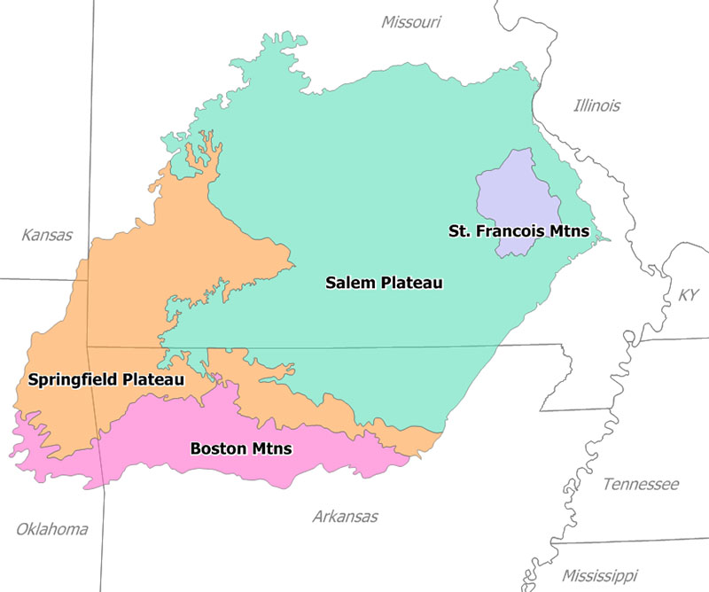
There are two mountain ranges in the Ozarks: the Boston Mountains of Arkansas and Oklahoma, as well as the St. Francois Mountains of Missouri. Wahzhazhe Summit (formerly known as Buffalo Lookout), is the highest point in the Ozarks at 2,561 feet (781 m), and is located in the Boston Mountains, in the westernmost part of Newton County, Arkansas, 6.2 miles (10.0 km) east of Boston, Madison County, Arkansas. Geologically, the area is a broad dome with the exposed core in the ancient St. Francois Mountains. The Ozarks cover nearly 47,000 square miles (120,000 km2), making it the most extensive highland region between the Appalachians and Rockies. Together with the Ouachita Mountains, the area is known as the U.S. Interior Highlands.
The Salem Plateau, named after Salem, Missouri, makes up the largest geologic area of the Ozarks. The second largest is the Springfield Plateau, named after Springfield, Missouri, nicknamed the "Queen City of the Ozarks". On the northern Ozark border are the cities of St. Louis and Columbia, Missouri. Significant Ozark cities in Arkansas include Fayetteville, Bentonville, Springdale, Eureka Springs, and Fort Smith. Branson, just north of the Arkansas–Missouri border, is a tourist destination where Ozark culture is popularized.
Etymology
[edit]The toponym Ozarks may derive from an English-language adaptation of the French abbreviation aux Arcs (short for French: aux Arcansas, meaning "of/at/to the Arkansas (Quapaw) [plural]").[2][3] In the decades prior to the French and Indian War of 1754 to 1763, aux Arkansas referred to France's trading post at Arkansas Post, located in the wooded Arkansas Delta lowland area above the confluence of the Arkansas River with the Mississippi River.[4][5][6]
Another possible etymological origin might be the French phrase aux arcs, meaning "[land] of the arches",[7] in reference to the dozens of natural bridges formed by erosion and collapsed caves in the Ozark region. These include Clifty Hollow Natural Bridge (actually a series of arches) in Missouri,[8] and Alum Cove in the Ozark–St. Francis National Forest.
By the early 20th century, the term "Ozarks" had entered common parlance.[9][10][need quotation to verify]
Physiographic subregions
[edit]
The Ozarks consist of five physiographic subregions: the Boston Mountains of north Arkansas and Cookson Hills of east Oklahoma; the Springfield Plateau of southwest Missouri, northeast Oklahoma, and northwest Arkansas and including Springfield, Joplin and Monett/Aurora in Missouri, Tahlequah in Oklahoma, and Fayetteville and Harrison in Arkansas; the White River Hills along the White River, including Branson and Mountain Home to Batesville; the Salem Plateau or Central Plateau, which includes a broad band across south central Missouri and north central Arkansas including the Lebanon, Salem and West Plains areas; the Courtois Hills of southeastern Missouri; the Osage-Gasconade Hills around the Lake of the Ozarks; the Saint Francois Mountains; and the Missouri River and Mississippi River border areas along the eastern and northeastern flanks.
Karst features such as springs,[11] losing streams, sinkholes and caves are common in the limestones of the Springfield Plateau and abundant in the dolomite bedrock of the Salem Plateau and Boston Mountains.[12] Missouri is known as "The Cave State" with over 7,300 recorded caves, second in number only to Tennessee. The majority of these caves are found in the Ozark counties.[12][13] The Ozark Plateaus aquifer system affects groundwater movement in all areas except the igneous core of the St. Francois Mountains.[14][15][16][17] Geographic features include limestone and dolomite glades, which are rocky, desert-like areas on hilltops. Kept open by periodic fires that limit growth of grasses and forbs in shallow soil, glades are home to collared lizards, tarantulas, scorpions, cacti and other species more typical of the Desert Southwest.[18][19]
The Boston Mountains contain the highest elevations of the Ozarks, with peaks over 2,500 feet (760 m), and form some of the greatest relief of any formation between the Appalachians and Rocky Mountains. The Ouachita Mountains to the south rise a few hundred feet higher, but are not geographically associated with the Ozarks. The Boston Mountains portion of the Ozarks extends north of the Arkansas River Valley 20 to 35 miles (32 to 56 km), is approximately 200 miles (320 km) long,[20] and is bordered by the Springfield and Salem Plateau to the north of the White River. Summits can reach elevations of just over 2,560 feet (780 m), with valleys 500 to 1,550 feet (150 to 470 m) deep. Turner Ward Knob is the highest named peak. Found in western Newton County, Arkansas, its elevation is 2,463 feet (751 m). Nearby, five unnamed peaks have elevations at or slightly above 2,560 feet (780 m). Drainage is primarily to the White River, with the exception of the Illinois River, although there also is considerable drainage from the south slopes of the Boston Mountains to the Arkansas River. Major streams of this type include Lee Creek, Frog Bayou, Mulberry River, Spadra Creek, Big Piney Creek, Little Piney Creek, Illinois Bayou, Point Remove Creek, and Cadron Creek. Many Ozark waterways have their headwaters in the uplands of the Boston formation, including the Buffalo, Kings, Mulberry, Little Red and White rivers.[21]
Topography is mostly gently rolling in the Springfield and Salem plateaus, whereas the Saint Francois Mountains are more rugged. Although the Springfield formation's surface is primarily Mississippian limestone and chert, the Salem Plateau is made of older Ordovician dolomites, limestones, and sandstones.[22] Both are rife with karst topography and form long, flat plains. The formations are separated by steep escarpments that dramatically interrupt the rolling hills. Although much of the Springfield Plateau has been denuded of the surface layers of the Boston Mountains, large remnants of these younger layers are present throughout the southern end of the formation, possibly suggesting a peneplain process.[23] The Springfield Plateau drains through wide, mature streams ultimately feeding the White River.[24]
Geology
[edit]The St. Francois Mountains in the northeastern Ozarks are the eroded remnants of an ancient range which form the geological core of the highland dome. The igneous and volcanic rocks of the St. Francois Mountains are the exposed remains of a Proterozoic mountain range hundreds of millions of years old. The remaining hills are the exposed portion of an extensive terrane (the Spavinaw terrane in part) of granitic and rhyolitic rocks dating from 1485 to 1350 mya that stretches from Ohio to western Oklahoma.[25] The core of the range existed as an island in the Paleozoic seas. Reef complexes occur in the sedimentary layers surrounding this ancient island. These flanking reefs were points of concentration for later ore-bearing fluids which formed the rich lead-zinc ores that have been and continue to be mined in the area. The igneous and volcanic rocks extend at depth under the relatively thin veneer of Paleozoic sedimentary rocks and form the basal crust of the entire region.[26]

A major unconformity in the region attests that the Ozarks were above sea level for several hundred million years from the time of the volcanism in the Precambrian until the mid-Cambrian with an erosionally produced relief of up to 1,500 feet (460 m).[26] The seas encroached during the late Cambrian producing the Lamotte Sandstone, 200 to 300 feet (61 to 91 m) thick, followed by carbonate sedimentation. Coral reefs formed around the granite and rhyolite islands in this Cambrian sea. This carbonate formation, the Bonneterre, now mostly dolomite, is exposed around the St. Francis Mountains, but extends in the subsurface throughout the Ozarks and reaches a thickness of 400 to 1,500 feet (120 to 460 m).[26] The Bonneterre is overlain by 500 to 600 feet (150 to 180 m) of dolomite, often sandy, silty or cherty, forming the Elvins Group and the Potosi and Eminence formations. Withdrawal of the seas resulted in another unconformity during the latest Cambrian and early Ordovician periods. Hydrothermal mineralizing fluids formed the rich lead ore deposits of the Lead Belt during this time.[26]

Sedimentation resumed in the Ordovician with the deposition of the Gunter sandstone, the Gasconade dolomite and the prominent Roubidoux sandstone and dolomite. The sandstone of the Roubidoux forms prominent bluffs along the streams eroding into the southern part of the Salem Plateau. The Roubidoux and Gunter sandstones serve as significant aquifers when present in the subsurface. The source of the sands is considered to be the emerging Wisconsin Dome to the northeast.[26] The Ozark region remained as a subsiding shallow carbonate shelf environment with a significant thickness of cherty dolomites such as the Jefferson City, Cotter and Powell formations.[26]
Portions of the Ozark Plateau, the Springfield Plateau of southwest Missouri and northern Arkansas, are underlain by Mississippian cherty limestones locally referred to as "Boone chert", consisting of limestone and chert layers. These are eroded and form steep hills, valleys and bluffs.
The Boston Mountains are a high and deeply dissected plateau. The rocks of the region are essentially little disturbed, flat-lying sedimentary layers of Paleozoic age. The highest ridges and peaks are capped by Pennsylvanian sandstone such as the basal Atoka and the "Middle Bloyd".[27] The deeply eroded valleys are cut into Mississippian limestone and below that layer Ordovician dolomite.
During the Pennsylvanian period, the Ozark Plateau was uplifted as a result of the Ouachita orogeny. During the late Paleozoic, the deep ocean basin that existed in central and southern Arkansas was lifted when South America collided with North America, creating the folded Ouachita Mountains and uplifting the Ozark plateau to the north.
Ecology and conservation
[edit]Formal conservation in the region began when the Ozark National Forest was created by proclamation of President Theodore Roosevelt in 1908 to preserve 917,944 acres (3,714.79 km2) across five Arkansas counties. Another 608,537 acres (2,462.66 km2) were added the following year. The initial forest included area as far south as Mount Magazine and as far east as Sylamore.[28]
In 1939, Congress established Mark Twain National Forest at nine sites in Missouri. Wildlife management areas were founded in the 1920s and '30s to restore populations to viable numbers. In the 1930s and 1940s Aldo Leopold, Arthur Carhart and Bob Marshall developed a "wilderness" policy for the Forest Service. Their efforts bore fruit with The Wilderness Act of 1964 which designated wilderness areas "where the earth and its community of life are untrammeled by men, where man himself is a visitor and does not remain", though this included second growth public forests like the Mark Twain National Forest.[29]
Land was also added to Ozark National Forest during this period, with over 544,000 acres (2,200 km2) in total additions. Some land was reclaimed by the government through the Resettlement Administration during the Great Depression.[28] In 1976, Congress established the Hercules Glades Wilderness, the first of 13 designated wilderness areas in the Ozarks. In 1986, Congress established the Ozark Plateau National Wildlife Refuge in northeast Oklahoma. Protected areas ensure the recovery of endangered and threatened species of animals and plants, including the red wolf, Ozark big-eared bat, Indiana bat, eastern small-footed bat, southeastern bat, southeastern big-eared bat; longnose darter, Ozark cavefish, Ozark cave crayfish, Bowman's cave amphipod, Ozark cave amphipod, bat cave isopod; and Ozark chinquapin. It is a habitat of migratory birds and contains geological, archeological, historical, and paleontological resources.
Commercial farms and processing operations are known to raise levels of chemical and biological contaminants in Ozark streams, threatening water supplies, recreational use and endangered native species.[30][31][32][33][34]
Lakes and streams
[edit]


Many of the rivers and streams in the Ozarks have been dammed. Most of the dams in the region were initially built for the dual purpose of flood control and hydropower generation but have also become major economic drivers through recreational use in places such as Branson, Missouri, and Mountain Home, Arkansas.
The Army Corps of Engineers among others, operates multiple dams in the Ozarks region. Some of the largest lakes created by these dams are on the White River. Beginning in 1911 with the construction of Powersite Dam on the White River near Branson, Missouri and the impoundment of Lake Taneycomo the Ozarks rivers have been harnessed for electrical power, recreation, and flood control. After President Franklin D. Roosevelt signed the Flood Control Act of 1938, six large flood control dams were constructed on the White River and its tributaries.
- Beaver Dam on the White River – Beaver Lake
- Table Rock Dam on the White River – Table Rock Lake
- Bull Shoals Dam on the White River – Bull Shoals Lake
- Norfork Dam on the North Fork River – Norfork Lake
- Greers Ferry Lake on the Little Red River – Greers Ferry Lake
- Clearwater Dam on the Black River – Clearwater Lake
Multiple smaller lakes have been created by dams in the White River basin from 1911 through 1960. These smaller lakes include Lake Sequoyah,[35] a small recreational fishing lake east of Fayetteville, Arkansas, formed in 1961; Sequoyah is the uppermost impoundment on the White River. Below Sequoyah (northeast of Fayetteville) is Beaver Lake, formed in 1960. The White River continues northeasterly into Table Rock Lake (1958) in Missouri, which feeds directly into Lake Taneycomo, where the river zigzags southeasterly into Arkansas forming Bull Shoals Lake along the Arkansas-Missouri line. Completed in 1952, Bull Shoals is the furthest downstream lake on the White River proper. Norfork Lake was formed by damming the North Fork River, a tributary of the White River, in 1941.
Additional large lakes in the Ozarks region include Lake of the Ozarks, Pomme de Terre Lake, and Truman Lake in the northern Ozarks. These three lakes were formed by impounding the Osage River and its tributary the Pomme de Terre River in 1931, 1961 and 1979 respectively.
Grand Lake o' the Cherokee in northeast Oklahoma, on the western portion of the Ozark Plateau, was created in 1940 with the damming of the Grand River. Stockton Lake was formed in 1969 by damming the Sac River near the city of Stockton, Missouri, and supplements the water supply of Springfield in nearby Greene County.
The creation of the lakes significantly altered the Ozark landscape and affected traditional Ozark culture through displacement.[36][37][38][39] The streams provided water and power to communities, farms and mills concentrated in the valleys prior to impoundment.[40] Many cemeteries, farm roads, river fords and railways were lost when the lakes came, disrupting rural culture, travel and commerce. Baxter County, Arkansas, alone saw nearly 400 people displaced to make way for the reservoir created by Norfork Dam. The town of Forsyth, Missouri, was relocated in its entirety to a spot 2 miles (3 km) from its previous location. Prior to damming, rivers and streams in the White and Osage River basins were of similar character to the current conditions of the Buffalo, Elk, Niangua, Gasconade, Big Piney, Current, Jacks Fork, Eleven Point and Meramec rivers.[36]
Because of the success of the Army Corps efforts to dam the large rivers in the Ozarks, the Ozarks Society began protests to keep the other rivers in the Ozarks free flowing. The Buffalo National River was created by an Act of Congress in 1972 as the nation's first National River, administered by the National Park Service. The designation came after over a decade of battling a proposed Army Corps dam in the media, legislature, and courts to keep the Buffalo River free flowing. The Ozark Society, the main force behind the dam protest, still leads the fight to keep the Buffalo River pristine and protected. Today, the Buffalo River sees approximately 800,000 visitors camping, canoeing, floating, hiking, and tubing annually.[41] In Missouri, the Ozark National Scenic Riverways[42] was established in 1964 along the Current and Jacks Fork rivers as the first US national park based on a river system. The Eleven Point River is included in the National Wild and Scenic Rivers System[43] established in 1968. These parks and rivers are a major economic driver for some of the least populated counties in Arkansas and Missouri, attracting up to 1.5 million tourists annually.
Many other waterways and streams have their headwaters in the Boston Mountains portion of the Ozarks such as the Mulberry River, the White River, War Eagle Creek, Little Mulberry Creek, Lee Creek, Big Piney Creek, and the Little Red River. To the south, the Arkansas River valley separates the Boston Mountains from the Ouachita Mountains.[44]
Missouri Ozark rivers include the Gasconade, Big Piney, and Niangua rivers in the north central region. The Meramec River and its tributaries Huzzah Creek and Courtois Creek are found in the northeastern Ozarks. The Black and St. Francis rivers mark the eastern crescent of the Ozarks. The James, Spring and North Fork rivers are in south-central Missouri. Forming the west central border of the Ozarks from Missouri through Kansas and into Oklahoma are the Spring River and its tributary, Center Creek. Grand Falls, Missouri's largest natural waterfall, a chert outcropping, includes bluffs and glades on Shoal Creek south of Joplin. All these river systems see heavy recreational use in season, including the Elk River in southwestern Missouri and its tributary Big Sugar Creek.
Ozark rivers and streams are typically clear water, with baseflows sustained by many seeps and springs, and flow through forests along limestone and dolomite bluffs. Gravel bars are common along shallow banks, while deep holes are found along bluffs.[45] Except during periods of heavy rain or snow melt — when water levels rise quite rapidly — their level of difficulty is suitable for most canoeing and tubing.
Fish hatcheries are common due to the abundance of springs and waterways.[38] The Neosho National Fish Hatchery was built in 1888; it was the first federal hatchery. The Arkansas Game and Fish Commission, Missouri Department of Conservation and U.S. Fish and Wildlife Service operate numerous warm and cold water hatcheries and trout parks;[46][47] private hatcheries such as at Rockbridge[48] are found throughout the region.
Regional economy
[edit]Traditional economic activity
[edit]The Ozarks contain ore deposits of lead, zinc, iron and barite. Many of these deposits have been depleted by historic mining activities, but much remains and is currently being mined in the Lead Belt of southeastern Missouri. Historically, the lead belt around the Saint Francois Mountains and the Tri-State district lead-zinc mining area around Joplin, Missouri, have been important sources of metals. Mining practices common in the early 20th century left significant abandoned underground mine problems and heavy metal contamination in topsoil and groundwater in the Tri-State district.[49][50]
Much of the area supports beef cattle ranching, and dairy farming is common across the area. Dairy farms are usually cooperative affairs, with small farms selling to a corporate wholesaler, who packages product under a common brand for retail sales. Petroleum exploration and extraction also takes place in the Oklahoma portion of the Ozarks, as well as in the east half of the Boston Mountains in Arkansas. Logging of both softwood and hardwood timber species on both private land and in the National Forests has long been an important economic activity.
The majority of the Ozarks is forested. Oak-hickory is the predominant type; eastern junipers are common, with stands of pine often seen in the southern range. Less than a quarter of the region has been cleared for pasture and cropland.[51] Forests that were heavily logged during the early-to-mid-20th century have recovered; much of the remaining timber in the Ozarks is second-growth forest. However, deforestation of frontier forest contributed through erosion to increased gravel bars along Ozark waterways in logged areas; stream channels have become wider and shallower, and deepwater fish habitat has been lost.[16]

The numerous rivers and streams of the region saw hundreds of water-powered timber and grist mills.[52][53] Mills were important centers of culture and commerce; dispersed widely throughout the region, mills served local needs, often thriving within a few miles of another facility. Few Ozark mills relied on inefficient water wheels for power; most utilized a dam, millrace and water turbine.[54]
During the New Deal, the Civilian Conservation Corps employed hundreds in the construction of nearly 400 fire lookouts throughout the Ozarks at 121 known sites in Arkansas[55] and 257 in Missouri.[56] Of those lookouts, about half remain, and many of them are in use by the U.S. Forest Service. A 2007 report by the National Trust for Historic Preservation deemed these fire lookouts and related structures as one of America's 11 Most Endangered Historic Places.[57]
In the 1960s, federal activity promoted modernization, especially through better transportation and tourism. The Ozarks Regional Commission sponsored numerous projects.[58]
Current economic activities
[edit]This section needs additional citations for verification. (October 2018) |
Tourism is the growth industry of the Ozarks as evidenced by the growth of the Branson, Missouri, entertainment center celebrating traditional Ozark culture.[39][59] The rapidly growing Northwest Arkansas metropolitan area has also become a tourist hub, drawing nationwide attention for the Crystal Bridges Museum of American Art in Bentonville, Arkansas.[60]
Poultry farming and food processing are significant industries throughout the region. The Tyson Foods corporation and ConAgra Foods each operates several hundred poultry farms and processing plants throughout the Ozarks. Schreiber Foods has operations throughout southern Missouri.
The trucking industry is important to the regional economy, with national carriers based there including J. B. Hunt, ABF, and Prime, Inc. Springfield remains an operational hub for the BNSF Railway. Logging and timber industries are also significant in the Ozark economy, with operations ranging from small family-run sawmills to large commercial concerns. Fortune 500 companies such as Wal-Mart, Leggett & Platt, Bass Pro Shops, and O'Reilly Auto Parts are based in the Ozarks.
The area is home to several Missouri wine and spirit regions, including the Ozark Highlands and Ozark Mountain American Viticultural Areas, and the Ozark Highland Spirits Region. There are a number of microbreweries throughout the region.[61]
Culture
[edit]"Ozark" also refers to the distinctive culture, architecture,[57][62] and dialect shared by the people who live on the plateau. Early settlers in Missouri were pioneers who came west from the Southern Appalachians at the beginning of the 19th century,[38][63] followed in the 1840s and 1850s by Irish and German immigrants. Much of the Ozark population is of English, Scots-Irish, and German descent, and the Ozark families from which the regional culture derived[63] tend to have lived in the area since the 19th century.[64][page needed]

Early settlers relied on hunting, fishing, trapping, and foraging to supplement their diets and incomes.[38] Today hunting and fishing for recreation are common activities and an important part of the tourist industry. Foraging for mushrooms (especially morels) and for ginseng is common and financially supported by established buyers in the area. Other forages include poke, watercress, persimmons and pawpaw; wild berries such as blackberry, black raspberry, raspberry, red mulberry, black cherry, wild strawberry and dewberry; and wild nuts such as black walnut and even acorns.[65] Edible native legumes, wild grasses and wildflowers are plentiful, and beekeeping is common.[66]
Print and broadcast media have explored Ozark culture broadly. Books set in the Ozarks include Where the Red Fern Grows, The Shepherd of the Hills,[59] and As a Friend.[67] The 1999 film Ride with the Devil, based on the book Woe to Live On,[68] depicts conflict in southwest Missouri during the Civil War.[69] Winter's Bone,[70] a novel by Daniel Woodrell (author of Woe to Live On), reflects on contemporary methamphetamine culture and its impact on families on the plateau. Released as a feature film in 2010, Winter's Bone received the Grand Jury Prize at the Sundance Film Festival, as well as other awards. Several early and influential country-music television and radio programs originated from Springfield in the 1950s and '60s, including ABC-TV's Ozark Jubilee and The Slim Wilson Show on KYTV. The Clampett clan of The Beverly Hillbillies TV show provide a stereotypical depiction of Ozark people. Ozark musicians include Porter Wagoner and old-time fiddler Bob Holt.[71] Netflix drama series Ozark takes place in Osage Beach, Missouri and revolves around the well-to-do Byrde family as their lives are uprooted and they are forced to move from Chicago to the Ozarks after a money laundering scheme goes wrong. The series focuses on the Byrdes' dealings in the Ozarks, as well as their interactions with local Ozark crime families. The series premiered on July 21, 2017.[72]
Examples of commercial interpretations of traditional Ozark culture include the two major family theme parks in the region, Silver Dollar City and the now defunct Dogpatch USA, and the resort entertainment complex in Branson. Ozark Folkways in Winslow, Arkansas, and Ozark Folk Center State Park in Mountain View, Arkansas, interpret regional culture through musical performance and exhibitions of pioneer skills and crafts.
Traditional Ozark culture includes stories and tunes passed orally between generations through community music parties and other informal gatherings.[73] Many of these tunes and tales can be traced to British origins[74] and to German folklore. Moreover, historian Vance Randolph attributes the formation of much Ozark lore to individual families when "backwoods parents begin by telling outrageous whoppers to their children and end by half believing the wildest of these tales themselves."[63] Randolph collected Ozark folklore and lyrics in volumes such as the national bestseller Pissing in the Snow and Other Ozark Folktales (University of Illinois Press, 1976), Ozark Folksongs (University of Missouri Press, 1980), a four-volume anthology of regional songs and ballads collected in the 1920s and 1930s,[74] and Ozark Magic and Folklore (Courier Dover Publications, 1964).[63] Evidenced by Randolph's extensive field work, many Ozark anecdotes from the oral tradition are often bawdy, full of wild embellishments on everyday themes.[75][76] In 1941–42, commissioned by Alan Lomax of the Archive of Folk Culture, Randolph returned to the Ozarks with a portable recording machine from the Library of Congress and captured over 800 songs, ballads and instrumentals.[77] Selected from among these several hundred recordings, 35 tracks were released on Various Artists: Ozark Folksongs (Rounder Records) in 2001.[74]

Square dances were an important social avenue throughout the Ozarks into the 20th century.[78][79][80] Square dances sprang up wherever people concentrated around mills and timber camps, springs, fords, and in towns small and large. Geographically isolated communities saw their own local dance tunes and variations develop.[78][79] Of all the traditional musicians in the Ozarks, the fiddler holds a distinct place in both the community and folklore.[78][79] Community fiddlers were revered for carrying local tunes; regionally, traveling fiddlers brought new tunes and entertainment, even while many viewed their arrival as a threat to morality.[71][78][79][80] In 2007, Gordon McCann, a chronicler of Ozarks folklife and fiddle music for over four decades, donated a collection of audio recordings, fieldnotes and photographs to Missouri State University in Springfield.[81] The collection includes more than 3,000 hours of fiddle music and interviews recorded at jam sessions, music parties, concerts and dances in the Ozarks. Selected audio recordings along with biographical sketches, photographs and tune histories were published in Drew Beisswenger and Gordon McCann's 2008 book/37-track CD set Mel Bay Presents Ozarks Fiddle Music: 308 Tunes Featuring 30 Legendary Fiddlers With Selections from 50 Other Great Ozarks Fiddlers.

From 1973 to 1983, the Bittersweet project, which began as an English class at Lebanon High School in Missouri, collected 476 taped and transcribed interviews, published 482 stories, and took over 50,000 photographs documenting traditional Ozark culture.[82]
Population influx since the 1950s,[37][39] coupled with geographically lying in both the Midwest and Upper South, proximity to the Mississippi embayment, the Osage and Northern Plains, contributes to changing cultural values in the Ozarks. Theme parks and theatres seen to reflect regional values have little in common with traditional Ozark culture. Community tradition bearers remain active, in decreasing numbers, far afield of commercial offers.[83][84]
Religion
[edit]Ozark religion, like that of Appalachia, was predominantly Baptist and Methodist during periods of early settlement; it tends to the conservative or individualistic, with Episcopalians, Assemblies of God, Baptists including Southern Baptists, Church of Christ, Pentecostals, and other Protestant denominations present, as well as Catholics.[85][86] Religious organizations headquartered in the Ozarks include the Assemblies of God and Baptist Bible Fellowship International in Springfield and the General Association of General Baptists in Poplar Bluff.
See also
[edit]
|
U.S. Wilderness Areas in the Ozarks
|
References
[edit]- ^ "Ozark Plateau | GeoKansas". geokansas.ku.edu. Retrieved August 25, 2024.
- ^ Okrent, Arika (August 20, 2014). "Why Isn't 'Arkansas' Pronounced Like 'Kansas'?" Mental Floss. Retrieved July 11, 2021.
- ^ Stewart, George R. (1967). Names on the Land: A Historical Account of Place-Naming in the United States. Boston: Houghton Mifflin. p. 137.
- ^ Randolph, Vance (1931). The Ozarks: An American Survival of Primitive Society. New York: The Vanguard Press. p. 14.
- ^ Arnold, Morris S. (1985). Unequal Laws Unto a Savage Race: European Legal Traditions in Arkansas, 1686-1836. Fayetteville: University of Arkansas Press. ISBN 0-938626-76-0.
- ^ Arnold, Morris S. (1991). Colonial Arkansas 1686-1804: A Social and Cultural History. Fayetteville: University of Arkansas Press. ISBN 1-55728-222-6.
- ^ Miller, E. Joan Wilson (1969). "The naming of the land in the Arkansas Ozarks: A study in culture processes". Annals of the Association of American Geographers. 59 (2): 240–251. doi:10.1111/j.1467-8306.1969.tb00668.x.
- ^ Watkins, Conor. "Ozarks geology: Clifty Creek Natural Area includes natural bridge" Archived February 4, 2015, at the Wayback Machine, The Ozarks Chronicle, Rolla, Mo.
- ^ Morrow, Lynn (1996). "Ozark/Ozarks: Establishing a Regional Term". White River Valley Historical Quarterly. 36 (2). Archived from the original on September 28, 2008. Retrieved September 8, 2006.
- ^ McMillen, Margot Ford. A to Z Missouri: The Dictionary of Missouri Place Names, Columbia, Missouri: Pebble Publishing, 1996. ISBN 0-9646625-4-X
- ^ Jerry D. Vineyard and Gerald L. Feder. Springs of Missouri. Missouri Department of Natural Resources and U.S. Geological Survey. 1974 (revised 1982).
- ^ a b Karst, Springs and Caves in Missouri, Missouri Department of Natural Resources
- ^ "Caves in Missouri". November 2019.
- ^ Rafferty, Milton. "The Ozarks as a Region: A Geographer's Description" Archived August 18, 2010, at the Wayback Machine, OzarksWatch, Vol. I, No. 4, Spring 1988.
- ^ Ozark Aquifer Map Archived November 9, 2008, at the Wayback Machine, United States Geological Survey.
- ^ a b Project Tour - A quick visit to the Ozarks Stream Geomorphology Project, United States Geological Survey.
- ^ "HA 730-D Ozark Plateaus aquifer system". usgs.gov. Retrieved May 26, 2015.
- ^ "Spatial Interaction Webs in Ozark Glades". John Chase, Assistant Professor. Washington University in St. Louis. Archived July 20, 2011, at the Wayback Machine
- ^ Ware, Stewart (2002). "Rock Outcrop Plant Communities (Glades) in the Ozarks: A Synthesis". The Southwestern Naturalist. 47 (4): 585–597. Bibcode:2002SWNat..47..585W. doi:10.2307/3672662. JSTOR 3672662.
- ^ Guccione, Margaret J. (January 7, 2008). "Boston Mountains". Encyclopedia of Arkansas History and Culture. Butler Center for Arkansas Studies at the Central Arkansas Library System. Retrieved June 30, 2013.
- ^ Foti, Thomas (August 26, 2011). "Ozark Mountains". Encyclopedia of Arkansas History and Culture. Butler Center for Arkansas Studies at the Central Arkansas Library System. Archived from the original on March 30, 2013. Retrieved June 30, 2013.
- ^ "Ozark Plateaus". Arkansas Geological Survey. Archived from the original on May 11, 2013. Retrieved June 30, 2013.
- ^ Purdue, A. H. (November–December 1901). "Physiography of the Boston Mountains, Arkansas". The Journal of Geology. 9 (8): 697. Bibcode:1901JG......9..694P. doi:10.1086/620967. S2CID 129914010.
- ^ Purdue, A. H. (November–December 1901). "Physiography of the Boston Mountains, Arkansas". The Journal of Geology. 9 (8): 698–700. Bibcode:1901JG......9..694P. doi:10.1086/620967. S2CID 129914010.
- ^ Denison, Rodger E., et al., Geology and Geochemistry of the Precambrian Rocks in the Central Interior Region of the United States, Geological Survey Professional Paper 1241-C, 1984
- ^ a b c d e f A. G. Unklesbay, Jerry D. Vineyard. Missouri Geology — Three Billion Years of Volcanoes, Seas, Sediments, and Erosion, University of Missouri Press, 1992. ISBN 0-8262-0836-3
- ^ "Ozark Plateaus". Archived from the original on May 22, 2016. Retrieved May 19, 2016.
- ^ a b United States Forest Service (1981). For the Trees: An Illustrated History of the Ozark-St. Francis National Forests 1908–1978. Archived from the original on April 2, 2015. Retrieved July 2, 2013.
- ^ Farmer, Charles J. (1999). A Personal Guide to Missouri Wilderness. University of Missouri Press. pp. 9–11.
- ^ "Endangered Species Guidesheet". Missouri Department of Conservation. Archived from the original on May 27, 2010.
- ^ "Research Project: Poultry Manure Management To Reduce Non-Point Source Phosphorus Pollution". United States Department of Agriculture: Agricultural Research Service.
- ^ Haggard, B. E.; Moore, P. A. Jr; Chaubey, I.; Stanley, E. H. (September 2003). "Nitrogen and Phosphorus Concentrations and Export from an Ozark Plateau Catchment in the United States". Biosystems Engineering. 86 (1): 75–85. Bibcode:2003BiSyE..86...75H. doi:10.1016/S1537-5110(03)00100-4.
- ^ "Missouri Water Quality Report: 2006" (PDF). Missouri Department of Natural Resources: Water Protection Program. April 1, 2007. Retrieved November 13, 2016.
- ^ Spellman, Derek (July 16, 2009). "Tribe urges swimmers to stay clear of Lost Creek, Spring River for now". The Joplin Globe. Archived from the original on January 11, 2013.
- ^ Boss, Stephen K., Heil-Chapdelaine, Vanessa M. "Mapping Landscape Change: An Historic and Bathymetric Study of Lake Sequoyah, Washington County, Arkansas" Archived November 5, 2014, at the Wayback Machine
- ^ a b Watkins, Conor. "The Meramec Basin Project: A Look Back 25 Years Later" Archived February 18, 2007, at the Wayback Machine. Ozark Mountain Experience. Article 69 & 70 Combined. 2006.
- ^ a b "Mountain Home (Baxter County)": The Encyclopedia of Arkansas History & Culture.
- ^ a b c d Campbell, Rex R. Campbell, Mary. Hughes, Colleen. "A Revolution in the Heartland: Changes in Rural Culture, Family and Communities, 1900–2000" Archived March 3, 2016, at the Wayback Machine. University of Missouri: Department of Rural Sociology. Columbia, Missouri. 2004.
- ^ a b c Area and Economic Overview: Southwest Missouri Overall Economic Development Program[dead link]. Southwest Missouri Council of Governments White Paper.
- ^ E. Joan Wilson Miller. Abstract "The Ozark Culture Region as Revealed by Traditional Materials". Annals of the Association of American Geographers, Volume 58 Issue 1, Pages 51-77. January 3, 1967.
- ^ Suzie, Rogers (April 14, 2010). "Buffalo National River". Encyclopedia of Arkansas History and Culture. Butler Center for Arkansas Studies at the Central Arkansas Library System. Retrieved June 30, 2013.
- ^ "Ozark National Scenic Riverways". Nps.gov. August 31, 2012. Retrieved January 6, 2013.
- ^ "Eleven Point River". National Wild & Scenic Rivers. U.S. Fish and Wildlife Service. Archived from the original on September 30, 2011. Retrieved October 8, 2011.
- ^ "Arkansas Lake Map, River Map and Water Resources". geology.com. Retrieved May 26, 2015.
- ^ MS Panfil, RB Jacobson. "Hydraulic Modeling of In-channel Habitats in the Ozark Highlands of Missouri: Assessment of Physical Habitat Sensitivity to Environmental Change". USGS-Biological Resources Division.
- ^ [1] Missouri Fish Hatcheries and Trout Parks Archived May 27, 2010, at the Wayback Machine
- ^ "Fish Hatcheries in Arkansas". Arkansas Department of Parks & Tourism. 2013. Archived from the original on December 6, 2013. Retrieved June 30, 2013.
- ^ "Rockbridge". Watersheds.org. Retrieved January 6, 2013.
- ^ Lasmanis, Raymond. Tri-State and Viburnum Trend Districts, Rocks & Minerals, November 1, 1997. Archived June 12, 2009, at the Wayback Machine
- ^ "GeoKansas: Lead and Zinc Mining" Archived July 6, 2008, at the Wayback Machine, Kansas Geological Survey. Updated May 5, 2005.
- ^ Primary Distinguishing Characteristics of Level III Ecoregions of the Continental United States Archived February 16, 2008, at the Wayback Machine, U.S. Environmental Protection Agency. Revised April 2000.
- ^ "Index to the old mills of Missouri". Hosted by rootsweb, this incomplete list includes almost 250 old mills in Missouri alone.
- ^ Barry County, MO Mills (Rootsweb)
- ^ Suggs, George E., Jr. Water Mills of the Missouri Ozarks. University of Oklahoma Press: Norman, Oklahoma. 1990
- ^ "Arkansas". Firelookout.org. Archived from the original on November 20, 2012. Retrieved January 6, 2013.
- ^ "Missouri". Firelookout.org. Archived from the original on November 20, 2012. Retrieved January 6, 2013.
- ^ a b "America's Most Endangered Historic Places Listings by Year - National Trust for Historic Preservation".
- ^ J. Blake Perkins, "Growing the Hills: The Ozarks Regional Commission and the Politics of Economic Development in the Mid-American Highlands, 1960s–1970s," Missouri Historical Review, 107 (April 2013), 144–67.
- ^ a b Snyder, Robert E. "Shepherd of the Hills Country: Tourism Transforms the Ozarks, 1880s-1930s". The Journal of American Culture, Volume 27 Issue 1, Pages 117-119.
- ^ Clark, Jayne (June 28, 2013). "Wal-Mart's hometown: 'Mayberry' goes Manhattan". USA Today. Retrieved June 30, 2013.
- ^ Sorensen, Brian (2017). Arkansas Beer: An Intoxicating History. Charleston, SC: American Palate. ISBN 978-1-4671-3755-3. Retrieved December 29, 2021.
- ^ Andy Ostmeyer. "Original Ozarks: Evidence of settlement before 1830 hard to find". Joplin Globe. June 21, 2009. According to the National Register of Historic Places, the Rice-Upshaw House, ca.1826, "is one of the two oldest remaining standing buildings in Arkansas, and a rare surviving example of a building from Arkansas' territorial period"; Wolf House, ca. 1825, overlooks the junction of the Norfork and White rivers; the Craighead-Henry House, ca. 1816, is "one of the oldest known structures in the interior [Missouri] Ozarks."
- ^ a b c d Randolph, Vance. Ozark Magic and Folklore. 367 pages. Courier Dover Publications, 1964.
- ^ Rafferty, Milton D. The Ozarks: Land and Life, University of Arkansas Press, 2nd ed., 2001. ISBN 1-55728-714-7
- ^ Phillips, Jan. Wild Edibles of Missouri. Missouri Department of Conservation, 2nd edition (1998). Cover, Introduction, Acknowledgments and Preface Archived May 1, 2015, at the Wayback Machine; Chapters Archived August 8, 2014, at the Wayback Machine; Color Plates Archived September 21, 2015, at the Wayback Machine.
- ^ The Naturalist. High Plains Films. Doug Hawes-Davis, Director. 32 minutes, Color/B&W, 2001.
- ^ Gander, Forrest. As a Friend Archived September 28, 2011, at the Wayback Machine. New York City: New Directions Publishing Corporation. 2008.
- ^ Woodrell, Daniel. Woe to Live On. Henry Holt, 1987.
- ^ Ward L. Schrantz. Jasper County, Missouri in the Civil War. 1923.
- ^ Woodrell, Daniel. Winter's Bone. Little, Brown and Company, 2006
- ^ a b Henigan, Julie. Play Me Something Quick and Devilish: Bob Holt – Old-Time Square Dance Fiddler, Musical Traditions, Article MT021, June 1998.
- ^ Loughrey, Clarisse (May 25, 2017). "Ozark trailer: Exclusive look at Netflix's gritty, dark new drug trade drama". The Independent. Archived from the original on May 24, 2022. Retrieved April 8, 2020.
- ^ Aunt Shelle Stormoe. "How to Spot a Genuine Ozark Hillbilly". October 23, 2008. Archived February 4, 2015, at the Wayback Machine
- ^ a b c Smith, Vic. Review of Ozark Folksongs, Musical Traditions, January 2001.
- ^ Randolph, Vance. "University of Illinois Press Catalog Entry on Pissing in the Snow and Other Ozark Folktales". Press.uillinois.edu. Retrieved January 6, 2013.
- ^ Florer, Faith L. "Book Review. Pissing in the snow and other Ozark folktales". Whole Earth Review. Summer, 1987. "Because of their—ahem—subject matter, the tales contained in this volume could not be published with Randolph's four great collections of Ozark material published in the 1950s, and have until recently been circulating only in manuscript and on elusive microfilm."
- ^ "Rounder Records Catalog Entry". Rounder.com. December 6, 2012. Retrieved January 6, 2013.
- ^ a b c d Karen Mulrenin, Rita Saeger and Terry Brandt. "Old-Time Ozark Square Dancing" Archived October 10, 2009, at the Wayback Machine. Bittersweet, Volume II, No. 1, Fall 1974.
- ^ a b c d Foreman, Diana. "Fiddlin' Around" Archived January 20, 2011, at the Wayback Machine. Bittersweet, Volume V, No. 2, Winter 1977.
- ^ a b Edited and photography by Allen Gage. "Old-Time Fiddling: A Traditional Folk Art With Four Ozark Musicians" Archived May 28, 2003, at the Wayback Machine, Bittersweet, Volume IX, No. 3, Spring 1982.
- ^ Gordon McCann pledges collection to Missouri State University: Four decades of material will be housed in Meyer Library. Missouri State University Press Release. September 26, 2007. Archived April 13, 2008, at the Wayback Machine
- ^ "Bittersweet". Thelibrary.springfield.missouri.org. Archived from the original on January 8, 2010. Retrieved January 6, 2013.
- ^ "Jam Sessions in Southwest Missouri". Missouri State University Libraries.
- ^ Bob Holt: Fiddler from the Missouri Ozarks. Local Legacies project of the Library of Congress.
- ^ "The Association of Religion Data Archives | Maps & Reports". Thearda.com. Archived from the original on May 10, 2008. Retrieved February 19, 2010.
- ^ "The Association of Religion Data Archives | Maps & Reports". Thearda.com. Archived from the original on March 27, 2017. Retrieved February 19, 2010.
Further reading
[edit]- Beisswenger, Drew & Gordon McCann, Mel Bay Presents Ozarks Fiddle Music: 308 Tunes Featuring 30 Legendary Fiddlers With Selections from 50 Other Great Ozarks Fiddlers. 2008.
- Harper, Kimberly D., White Man's Heaven: The Lynching and Expulsion of Blacks in the Southern Ozarks, 1894-1909, University of Arkansas Press, 2010.
- Harper, Kimberly D., Men of No Reputation: Robert Boatright, the Buckfoot Gang, and the Fleecing of Middle America, University of Arkansas Press, 2025.
- Rafferty, Milton D. The Ozarks: Land and Life. Fayetteville, AR: University of Arkansas Press, 2001.
- Rafferty, Milton D. "Agricultural Change in the Western Ozarks" Missouri Historical Review 69 (April 1975): 299-322. online
- Randolph, Vance. The Ozarks: An American Survival of Primitive Society. 1931.
- Rossiter, Phyllis. A Living History of the Ozarks Gretna, LA: Pelican, 1992.
- Phillips, Jared. Hipbillies: Deep Revolution in the Arkansas Ozarks Fayetteville, AR: University of Arkansas Press, 2019.
Folklore
[edit]- Gilmore, Robert Karl. Ozark Baptizings, Hangings, and Other Diversions: Theatrical Folkways of Rural Missouri, 1885-1910 Norman, OK: University of Oklahoma Press, 1984.
- Morrow, Lynn, and James Keefe, eds. White River Chronicles. Fayetteville, AR: University of Arkansas Press, 1994.
- McNeil, W. K.Ozark Country. Jackson, MS: University Press of Mississippi, 1995.
- Randolph, Vance. Ozark Folksongs. In four volumes. Columbia, MO: University of Missouri Press, 1980)
History
[edit]- A reminiscent history of the Ozark region: comprising a condensed general history, a brief descriptive history of each county, and numerous biographical sketches of prominent citizens of such counties (1894) full text Archived February 8, 2016, at the Wayback Machine
- Blevins, Brooks, A History of the Ozarks: Volume 1: The Old Ozarks. Urbana, IL: University of Illinois Press, 2018.
Tourism
[edit]- Morrow, Lynn, and Linda Myers-Phinney. Shepherd of the Hills Country: Tourism Transforms the Ozarks, 1880s–1930s. Fayetteville, AR: University of Arkansas Press, 1999.
External links
[edit]- "Ozark Mountain Forests". Terrestrial Ecoregions. World Wildlife Fund.
- Ozark National Scenic Riverways
- Smith, Scott M. "Ozark Aquifer". Introduction to Hydrogeology. Emporia State University. Archived from the original on January 24, 2015. Retrieved April 12, 2014.
- Ozark Plateau National Wildlife Refuge
- Ozark Mountains, Encyclopedia of Arkansas History & Culture, The Central Arkansas Library System.
- The Intimate Wild: Ozark Highlands Trail, National Geographic, 10/2008.
- "Closest to Everlastin'": Ozark Agricultural Biodiversity and Subsistence Traditions, 9/2010.
- Abbott, B. Nick; Marston, Richard A. (2009). "Ozark Plateau". Encyclopedia of Oklahoma History and Culture. Oklahoma Historical Society.
Mountains of Arkansas | |
|---|---|
| Ouachita Mountains | |
| Ozarks | |
| Others | |
| International | |
|---|---|
| National | |
| Other | |
Ozarks
View on GrokipediaEtymology
Origins and Historical Usage
The term "Ozarks" originates from the French phrase aux Arcs, a shortened form of aux Arkansas, which alluded to the bends of the Arkansas River or the Quapaw (Arkansas) people, whose name derived from their prowess with bows and arrows.[5] This linguistic adaptation entered English usage through early explorers and traders in the region, reflecting French colonial mapping of the Mississippi River valley where the Quapaw resided.[6] Folklore attributing the name to unrelated terms like "Azoic Arc Monts" or "Bois Aux Arcs" lacks primary evidentiary support and stems from later speculative interpretations rather than direct historical records.[7] The earliest printed reference to "Ozark" appears in the 1809 travel account of English naturalist John Bradbury, who described the terrain during his journeys along the Mississippi and Missouri rivers.[8] The plural form "Ozarks" and the designation "Ozark Mountains" emerged shortly thereafter, with the latter first mapped during the U.S. Army's Long Expedition of 1819–1820, which documented the highlands of southern Missouri and northern Arkansas under that label.[9] By the mid-19th century, American settlers and surveyors had popularized "Ozarks" as a regional descriptor, shifting from singular to plural usage to denote the broader elevated area, as evidenced in federal land surveys and periodicals of the era.[10] Despite the common appellation "Ozark Mountains," the region constitutes a dissected plateau rather than true mountains, a classification formalized by the U.S. Geological Survey (USGS) as the Ozark Plateaus physiographic province, characterized by uplifted Paleozoic sedimentary rocks eroded into rugged hills rather than orogenic peaks.[11] This nomenclature evolved through 19th- and 20th-century geological assessments, which distinguished the Ozarks' karstic, stream-dissected topography from Appalachian or Rocky Mountain ranges, emphasizing uplift and fluvial erosion over tectonic folding.[12] The USGS's hydrogeologic mappings, beginning in the late 19th century, reinforced this plateau designation in official reports, correcting earlier hyperbolic settler terminology.[13]Physical Geography
Physiographic Subregions
The Ozark Plateau is subdivided into four primary physiographic subregions—the St. Francois Mountains, Salem Plateau, Springfield Plateau, and Boston Mountains—differentiated by elevation ranges, terrain ruggedness, and drainage dissection patterns. These subregions encompass approximately 47,000 square miles (122,000 km²), with the majority in southern Missouri, and smaller portions extending into northern Arkansas, northeastern Oklahoma, and southeastern Kansas. Boundaries between subregions are transitional rather than sharply defined, reflecting gradual shifts in topographic relief and slope gradients.[14][12][15] The St. Francois Mountains form the eastern core of the Ozarks, exhibiting the most rugged terrain among the subregions with narrow ridges, steep valleys, and local relief exceeding 500 feet (152 m). Elevations here peak at 1,772 feet (540 m) on Taum Sauk Mountain, Missouri's highest point, with average heights around 1,200–1,500 feet (366–457 m); drainage follows entrenched patterns along resistant uplands, contributing to isolated, knob-dominated landscapes. Forest cover predominates, with thinner soils supporting oak-hickory woodlands over about 80% of the area.[16][17] The Salem Plateau occupies the northern Ozarks, featuring broad, rolling uplands at average elevations of 1,500 feet (457 m) and moderate relief of 200–400 feet (61–122 m) between hilltops and valleys. Terrain consists of flat-topped divides dissected by meandering streams, fostering karst-influenced drainage that promotes rapid infiltration over surface runoff; this subregion, the largest by area, has cherty soils conducive to pasture and timber, with forest cover on steeper slopes and open woodlands on plateaus. Land use emphasizes grazing and selective logging, reflecting the subdued topography.[18][12] The Springfield Plateau lies centrally, characterized by a gently undulating surface at elevations averaging 1,800 feet (549 m), with low relief typically under 150 feet (46 m) except in stream-dissected margins. Drainage networks are dendritic, with broader valleys enabling agricultural development; fertile loess-derived soils support crop farming and pastures across roughly 40% of the subregion, interspersed with prairie remnants and oak savannas on less sloped areas. This plateau's flatter terrain contrasts with surrounding uplands, facilitating higher population densities and mixed land uses.[18][19] The Boston Mountains represent the southern and highest subregion, with elevations surpassing 2,000 feet (610 m) on average and peaks reaching 2,561 feet (781 m) at Wahzhazhe Summit; steep slopes, V-shaped valleys, and relief up to 1,500 feet (457 m) define a highly dissected terrain where parallel ridges trend northeast-southwest. Drainage is vigorous, with streams incising deeply into the landscape, promoting dense forest cover—primarily oak and hickory—over 90% of the area and limiting agriculture to narrow bottomlands; thin, rocky soils underscore the subregion's emphasis on forestry and recreation.[20][21]Geology and Geomorphology
The Ozark Plateau consists primarily of Paleozoic sedimentary rocks, including Ordovician through Pennsylvanian limestones, dolomites, sandstones, and shales, deposited in shallow marine environments.[22] Uplift during the late Paleozoic Era, particularly in the Pennsylvanian Period as part of the Ouachita orogeny, elevated these strata into a broad dome-shaped structure without intense folding or faulting characteristic of orogenic belts like the Appalachians.[12] Subsequent differential erosion over tens of millions of years has sculpted the landscape, with resistant Pennsylvanian sandstones forming caps over more soluble Mississippian and Ordovician limestones, resulting in the dissected plateau topography.[23] In the eastern St. Francois Mountains, the oldest exposed rocks are Precambrian igneous formations, including rhyolites and granites dated to approximately 1.48 billion years ago, representing anorogenic volcanic and plutonic activity that predates the Paleozoic cover.[24] Erosion has removed overlying sediments, exposing these basement rocks and creating an unconformity visible at sites like Taum Sauk, where Precambrian rhyolites underlie Cambrian strata. The geomorphology is dominated by karst features arising from the dissolution of soluble carbonate rocks, producing sinkholes, caves, and prolific springs across the plateau.[25] Notable examples include extensive cave systems in the Ozark National Scenic Riverways and large karst springs discharging millions of gallons daily, facilitated by groundwater flow through fractured limestones.[26] The region has experienced no significant tectonic activity since the Paleozoic uplift, contributing to its seismic stability; earthquake records show low-frequency, minor events in the plateau interior, with higher risks confined to peripheral zones like the New Madrid Seismic Zone.[27][28]Hydrology
Major Lakes
The Ozarks contain few natural lakes, as the region's karst topography—characterized by soluble limestone and dolomite—facilitates rapid drainage through sinkholes, caves, and underground channels, preventing significant surface water accumulation.[29][30] Most standing bodies of water are artificial reservoirs created by dams constructed primarily in the mid-20th century for flood control, hydropower generation, and water supply.[31] These impoundments support regional hydrology by storing floodwaters and releasing them controllably, while also enabling navigation and recreation on rivers like the White and Osage. The largest reservoir, Lake of the Ozarks, was formed by the completion of Bagnell Dam on the Osage River in 1931, following construction that began in August 1929 under Union Electric Company (now Ameren Missouri).[32][33] The dam, a 2,543-foot-long concrete gravity structure rising 148 feet, impounds approximately 55,000 acres of surface area with over 1,150 miles of jagged shoreline and a main channel extending 92 miles.[34][35] Primarily designed for hydroelectric power, it generates electricity via eight turbines, though it also aids flood mitigation.[36] Several reservoirs on the White River basin were engineered by the U.S. Army Corps of Engineers. Table Rock Lake, impounded by Table Rock Dam completed in 1958, spans 43,100 acres across Missouri and Arkansas, with the dam—a 6,423-foot-long earth and concrete structure—standing 252 feet high and providing 3,462,000 acre-feet of total storage, including 760,000 acre-feet dedicated to flood control.[37] Bull Shoals Lake, downstream and formed by Bull Shoals Dam finished in 1952, covers about 45,000 acres and features a 2,256-foot-long concrete dam rising 263 feet, ranking as the fifth-largest concrete dam in the U.S. at the time of construction, with eight generators capable of processing 10 million gallons of water per minute for power and flood management.[38][39] These Corps projects exemplify multi-purpose engineering, prioritizing flood storage upstream to protect downstream areas while integrating hydropower.[31] Other notable impoundments include Stockton Lake on the Sac River (Corps, 1969, ~25,000 acres) and smaller reservoirs like Lake Taneycomo, a flow-through tailwater from Table Rock Dam maintained at consistent levels for cold-water fisheries. Collectively, these reservoirs exceed 200,000 acres of surface area, though sediment accumulation—monitored by USGS at rates varying by watershed, such as 0.5-2 tons per acre per year in similar karst-influenced systems—necessitates ongoing dredging to preserve capacity.[40]| Reservoir | Impounding Dam | Completion Year | Surface Area (acres) | Dam Height (ft) | Primary Functions |
|---|---|---|---|---|---|
| Lake of the Ozarks | Bagnell | 1931 | 55,000 | 148 | Hydropower, flood control |
| Table Rock Lake | Table Rock | 1958 | 43,100 | 252 | Flood control, hydropower |
| Bull Shoals Lake | Bull Shoals | 1952 | ~45,000 | 263 | Flood control, hydropower |
Rivers and Streams
The hydrological network of the Ozarks consists primarily of short, steep streams with high gradients, resulting from the dissection of the Ozark Plateau, a uplifted and eroded dome structure.[12] Drainage patterns are predominantly radial, directed away from regional highs such as the Salem Plateau and St. Francois Mountains, with major rivers including the White River (draining southward into the Arkansas River), Black River (a White tributary), Current River (flowing east to the Mississippi), and Gasconade River (northward to the Missouri River).[41] [42] These streams typically feature clear, cool waters over chert gravel beds, supporting high baseflows from karst aquifers.[41] Karst topography profoundly influences streamflow, with numerous losing streams that disappear into sinkholes and fractures in soluble limestone and dolomite bedrock, recharging groundwater before emerging as large springs.[43] [44] Prominent examples include springs along the Current and Jacks Fork rivers, which maintain perennial flows even during droughts; for instance, Big Spring discharges approximately 846 cubic feet per second on average.[45] This subsurface connectivity results in rapid pollutant transport risks but sustains scenic, floatable rivers like the Current, protected under the Ozark National Scenic Riverways established by Congress on August 24, 1964.[46] [47] Flow regimes exhibit marked seasonal variability, with low summer discharges reliant on spring baseflow (often 70-90% of total flow) and sharp increases during spring rains or thunderstorms, leading to frequent flash flooding on tributaries.[48] USGS gauging stations record peak discharges that can exceed mean flows by factors of 100 or more; for example, the Current River at Van Buren has documented annual peaks ranging from 1,000 to over 100,000 cubic feet per second in extreme events.[12] [49] Recent analyses indicate increasing flood magnitudes linked to intensified precipitation extremes in the Midwest.[50]Ecology and Biodiversity
Flora and Fauna
The Ozarks feature a temperate oak-hickory forest ecosystem, where mixed deciduous forests dominated by oaks (such as white oak, Quercus alba, and red oak, Quercus rubra) and hickories (Carya spp.) cover the majority of the landscape, comprising approximately three-fourths of the tree species in Missouri's upland forests, which extend across much of the region.[51][52] These species are adapted to the area's dissected plateaus and karst topography, with deep root systems enabling drought tolerance in thin soils and mast production supporting wildlife food webs. Black walnut (Juglans nigra) occurs in riparian zones and moist slopes, contributing to diverse understories alongside dogwood and serviceberry.[53] Distinct glade habitats interrupt the forest matrix, characterized by exposed bedrock and xeric conditions that favor prairie grasses like little bluestem (Schizachyrium scoparium), sideoats grama (Bouteloua curtipendula), and switchgrass (Panicum virgatum), often fringed by eastern redcedar (Juniperus virginiana).[54] These open, rocky clearings mimic prairie-desert transitions, with grasses exhibiting C4 photosynthesis for efficient water use in low-rainfall microsites.[55] Mammalian fauna includes abundant white-tailed deer (Odocoileus virginianus), eastern wild turkey (Meleagris gallopavo silvestris), and black bears (Ursus americanus), which forage on acorns, fruits, and insects in the oak-hickory canopy.[56] Karst aquifers support endemic troglobites like the Ozark cavefish (Amblyopsis rosae), a sightless, unpigmented species restricted to subterranean streams in Missouri, Arkansas, and Oklahoma, where it feeds on microcrustaceans via heightened sensory adaptations.[57][58] Breeding Bird Survey data reveal population declines in canopy-dwelling species such as the cerulean warbler (Setophaga cerulea), down over 70% regionally since the 1960s due to habitat fragmentation, though they preferentially nest in mature forest gaps.[59][60] Karst zones, documented by Missouri and Arkansas heritage inventories, emerge as biodiversity hotspots with over 900 cave-associated species, including salamanders and amphipods reliant on stable, nutrient-poor groundwater flows.[61][62]Conservation Challenges and Empirical Data
Forest cover in the Ozarks has remained relatively stable at approximately 85% since the early 20th century, following extensive reforestation after widespread logging in the late 1800s and early 1900s that reduced Missouri's forests from about 70% coverage.[63] [64] This recovery reflects natural regeneration and management practices rather than pristine conditions, with second-growth forests dominating the landscape.[65] Between 1973 and 2000, the Ozark Highlands experienced a net land-cover change of 5.9%, primarily involving minor shifts from forest to agriculture or development, but overall tree cover loss has been limited compared to historical deforestation peaks.[66] Primary threats include invasive species such as the emerald ash borer (Agrilus planipennis), an Asian beetle first detected in Missouri in 2010, which has killed tens of millions of ash trees across North America by boring into trunks and disrupting nutrient flow, even in healthy specimens.[67] [68] In the Ozarks, infestations have prompted tree removals in parks and forests, altering canopy structure and increasing vulnerability to further pests.[69] [70] Urban sprawl contributes modestly to habitat fragmentation, with urban land expanding by about 56% (roughly 3,515 km²) in the broader Gulf Coastal Plains and Ozarks ecoregion from 1973 to 2000, converting small forest patches to development.[71] However, these losses are dwarfed by historical agricultural clearances, and recent data show net forest gains in some subregions due to farm abandonment.[66] Conservation efforts are bolstered by federal and state protected areas, including Mark Twain National Forest, encompassing 1.5 million acres across 29 Missouri counties, which maintains working forests through sustainable practices.[72] State wildlife management areas have facilitated game species recovery; white-tailed deer populations rebounded from near-extirpation via regulated hunting, while wild turkeys, restocked from game farms starting in the 1920s, now thrive in fair to good numbers across Ozark habitats.[73] [74] These successes stem from habitat management and harvest controls, demonstrating effective causal interventions over broad alarmism. Empirical climate data indicate a modest temperature increase of about 1°F in the Midwest, including the Ozarks, since 1900, aligned with regional patterns rather than accelerated shifts.[75] Precipitation remains variable with no long-term trend toward extremes, averaging 40-50 inches annually, influenced more by natural cycles than directional change.[76] Climate models projecting biome shifts, such as oak-hickory dominance yielding to mesophytic forests, often disagree on specifics and overpredict transformations without robust causal evidence linking anthropogenic factors to observed variability, as historical fire suppression and land-use changes exert stronger local influences.[77] [78] Reforestation itself has mitigated warming in the eastern U.S. by enhancing carbon sequestration.[79]History
Indigenous Peoples and Pre-Columbian Era
The earliest evidence of human presence in the Ozarks dates to the Paleo-Indian period, with Clovis culture artifacts indicating occupation around 11,000 to 10,000 BCE. Sites such as Big Eddy in southwest Missouri contain stratified horizons with Clovis fluted projectile points, associated with the hunting of megafauna like mammoth and bison in the region's post-glacial landscapes.[80] These nomadic hunter-gatherers exploited the diverse terrain of uplands and river valleys, adapting to environmental shifts as ice-age fauna declined.[81] During the Woodland period (circa 500 BCE to 1000 CE), populations transitioned toward more sedentary patterns, evidenced by bluff shelters and open settlements in the Arkansas and Missouri Ozarks. Artifacts including cord-marked pottery, bow-and-arrow points, and burial mounds reflect increased reliance on horticulture, supplemented by hunting deer and gathering nuts in the oak-hickory forests.[82] Trade networks extended exotic materials like marine shells and copper into the region, linking Ozark groups to broader eastern North American exchanges during the Hopewell interaction sphere.[83] High artifact densities in riverine sites suggest seasonal aggregations tied to resource availability, with semi-permanent villages forming in fertile valleys.[84] Mississippian influences reached the Ozarks peripherally from circa 1000 to 1400 CE, introducing shell-tempered pottery and maize agriculture, though mound-building was limited compared to lowland centers like Cahokia. Upland adaptations emphasized hunting and foraging over intensive farming, with artifacts showing symbolic exchanges via long-distance networks distributing chert and ceremonial items.[85] Late prehistoric groups, ancestral to Siouan-speaking tribes such as the Osage, dominated the highlands by maintaining semi-nomadic cycles focused on bison and deer hunts across the plateau, utilizing the dissected topography for seasonal mobility and resource partitioning.[86] This pattern persisted into the immediate pre-contact era, with evidence of villages near streams and upland foraging camps reflecting ecological realism in a rugged, resource-variable environment.[87]European Exploration and Settlement
The first documented European incursion into the Ozarks occurred during Hernando de Soto's Spanish expedition in 1541, when his forces crossed the Mississippi River into present-day Arkansas, encountering Native American groups but establishing no permanent presence. French exploration followed in the late 17th and 18th centuries, driven by fur trading with tribes such as the Osage and early mineral prospecting; lead deposits at Mine La Motte, near present-day Fredericktown, Missouri, were identified around 1720 by expeditions under figures like Antoine de la Mothe Cadillac and Philip François Renault, marking the region's first European mining operations.[88][89] These activities remained limited to traders and small outposts, with no widespread settlement until after the U.S. acquisition of the Louisiana Territory in 1803, which opened the area to American traders and surveyors.[90] American exploration intensified in the early 19th century, exemplified by Henry Rowe Schoolcraft's 1818–1819 surveys of southern Missouri's Ozark highlands, documenting geography, resources, and Native inhabitants for potential settlement.[91] Waves of migrants from Appalachia and the upland South arrived between the 1810s and 1840s, primarily via overland routes, drawn by cheap land grants under federal policies; these pioneers, often Scotch-Irish or "old-stock" Americans, cleared forested plateaus and valleys for dispersed subsistence farms emphasizing corn, hogs, cattle, and foraging from woodland mast, supplemented by hunting and rudimentary lead mining.[92][93] Self-sufficiency defined these homesteads, with families relying on local timber for log cabins, springs for water, and minimal external trade, as evidenced by low population densities and isolated farmsteads averaging 100–200 acres per household.[92] Settlement coincided with Native American displacement under U.S. removal policies; the Trail of Tears in the 1830s routed thousands of Cherokee through Ozark corridors in Arkansas (via routes near Batesville and the White River) and Missouri (including segments near Springfield), where detachments endured harsh terrain, disease, and winter conditions en route to Indian Territory, altering local demographics and land availability for white homesteaders.[94][95] Lead mining at sites like Mine La Motte expanded modestly with American operators, employing free laborers and slaves, but remained secondary to agrarian pursuits until later decades.[88] This era solidified the Ozarks' pattern of rugged individualism, with settlers adapting to karst topography and isolation through diversified, low-input livelihoods.[92]19th-Century Development and Civil War Impacts
In the early to mid-19th century, the Ozarks saw initial economic stirrings from small-scale mining operations, particularly lead extraction in southeast Missouri's hills, which attracted limited investment before larger booms in the post-war era.[96] Zinc mining emerged in districts like Joplin by the late 1800s, drawing laborers and spurring transient boomtowns amid rugged terrain that limited scalability.[97] These activities laid groundwork for resource extraction but remained modest until transportation improvements. Railroad expansion accelerated development in the 1870s, with the St. Louis–San Francisco Railway (Frisco) extending lines into the region, reaching Pierce City by June 1870 and Neosho later that year, enabling efficient export of timber and emerging fruit crops like apples from Ozark orchards.[98] This infrastructure spurred a timber boom from around 1880 to the 1910s, as logging railroads penetrated forests for shortleaf pine harvesting and ties, transforming hinterlands into export corridors while boosting local mills.[99] Commercial fruit-growing gained traction post-rail arrival, with shipments to urban markets highlighting the Ozarks' fertile valleys.[100] The American Civil War (1861–1865) profoundly disrupted this trajectory, as Missouri's Ozarks became a hotspot for bushwhacker guerrilla warfare, with Confederate sympathizers hiding in forested backcountry to ambush Union forces and civilians amid deep familial and community divisions.[101] The state's split loyalties fueled over 1,100 battles and skirmishes statewide, many involving scorched-earth tactics that razed farms, bridges, and mills, severing market ties and forcing reversion to subsistence living.[102] [103] Economic devastation was acute, with livestock slaughtered, crops burned, and populations displaced, compounding pre-war tensions from border conflicts.[104] Post-war recovery hinged on resilient family farms, where smallholders—predominantly non-slaveholding whites—reestablished self-sufficient operations on hilly plots, emphasizing diversified crops and livestock over commercial scale amid depleted resources and ongoing banditry.[105] Folk economies persisted through barter and local crafts, gradually rebuilding amid sparse infrastructure until railroads revived export potential.[106]20th-Century Industrialization and Modern Era
The logging industry in the Ozarks reached its peak between the 1880s and 1920s, with extensive clear-cutting of hardwood forests for timber, railroad ties, and fuel, leading to widespread denudation of hillsides and subsequent soil erosion.[63][99] This exploitation phase prompted federal intervention, culminating in the establishment of the Ozark National Forest on March 6, 1908, to conserve remaining woodlands and promote reforestation. From the 1930s to the 1960s, large-scale dam construction transformed the region's hydrology and economy, primarily under the Flood Control Act of 1938, which authorized projects like Norfork Dam (completed 1944) and Beaver Dam (construction began 1960, completed 1966) for flood mitigation, hydroelectric power, and recreation.[107][108] These Corps of Engineers initiatives inundated valleys, displaced communities, but stabilized agriculture and spurred lakeside development. Mid-20th-century manufacturing diversified the economy, with poultry processing emerging as a dominant sector in Arkansas's Ozark counties; by the 1950s, firms like Tyson Foods scaled operations, processing millions of birds annually and employing thousands in integrated supply chains.[109] Furniture production also leveraged local hardwoods, with mills in Missouri and Arkansas crafting oak and hickory pieces for regional and national markets.[110] In the 2020s, tourism experienced a surge, exemplified by the Lake of the Ozarks attracting over 10 million visitors in 2020 alone, driven by outdoor recreation and amplified by the Netflix series Ozark, boosting lodging and hospitality revenues.[111] Concurrently, remote work enabled by the COVID-19 pandemic facilitated migration from urban areas, altering demographics around lakes and small towns with influxes of telecommuters seeking affordable housing and natural amenities.[112] The seven-county Ozark region in Missouri recorded an 8.1% population increase from 2010 to 2020, reflecting these trends amid broader rural revitalization.[113]Demographics
Population Composition and Trends
The population of the Ozarks is predominantly non-Hispanic white, exceeding 90% in representative counties such as Ozark County, Missouri, where it comprised 93.9% in 2022, up from 96.6% in 2010 due to modest diversification.[114] Small African American communities persist, often tracing to antebellum slavery, with percentages around 1% or less, as in 1.2% for Ozark city, Missouri.[115] Native American populations form localized enclaves, particularly Cherokee descendants in the Oklahoma portion, though overall representing under 1% regionally.[116] Population density remains low across the roughly 47,000-square-mile plateau, typically 50-100 people per square mile in rural zones, with elevations near urban hubs like Springfield, Missouri, or lake developments.[12] The median age skews older than the national average of 38.5, averaging around 42 regionally owing to youth outmigration and elderly retention, exemplified by 53 in Ozark County.[117] Demographic trends include rural depopulation from economic outmigration, partially countered by retiree influxes to lake vicinities, and notable Hispanic growth since the 1990s, driven by labor in Arkansas processing sectors, where the Ozark District saw over 600% increase from 1990 to 2006.[118] This shift raised Hispanic shares to 2.6% in areas like Ozark County by 2022, from near negligible levels. Overall, the region sustains low-density, aging demographics with incremental ethnic diversification.[120]Migration and Urban-Rural Dynamics
The Ozark region in Missouri recorded a population increase of over 8 percent between 2010 and 2020, with net in-migration contributing significantly to this growth amid broader rural-to-rural shifts within the state.[121] Counties around the Lake of the Ozarks, such as Camden, saw net gains exceeding 3,000 in-migrants during the same decade, reflecting inflows from higher-cost urban areas.[122] Lower living costs, averaging 15-20 percent below national urban averages in rural Ozark counties, have driven these patterns, as households seek affordable housing and natural amenities while maintaining remote work enabled by post-2020 technological shifts.[123] Post-2020, urban flight accelerated, with St. Louis losing approximately 21,700 residents between 2020 and 2024, many relocating to Ozark lake communities and smaller cities like those near Branson and Springfield for lifestyle and economic reasons.[124] Kansas City metro expansions into surrounding counties indirectly bolstered Ozark inflows via regional commuting networks, though direct net migration data for the broader Ozarks post-pandemic remains limited to county-level estimates showing positive balances in tourism-adjacent areas.[123] This influx correlates with remote work adoption, as federal data indicate nonmetropolitan areas gained nearly 1 million migrants nationally from 2020 to 2024, 69 percent domestic, with Ozark locales benefiting from Missouri's intrastate patterns.[125] Youth retention faces challenges from limited local job opportunities in non-tourism sectors, contributing to outmigration rates where rural Missouri counties lose 1-2 percent of their 18-34 demographic annually due to scarce high-skill employment.[126] Brain drain is evident in the Ozarks, mirroring Midwest trends where college-educated residents depart for urban centers at rates 20-30 percent higher than inflows, driven by wage gaps—median rural Ozark incomes hover at $45,000 versus $60,000-plus in Springfield.[127] Some counter this via reverse commuting, with infrastructure like the expanded U.S. Route 65 facilitating daily travel from rural Ozark homes to jobs in Springfield (28 miles from Ozark, MO) or Branson's service economy.[128] In-migration has strained infrastructure, particularly housing around major lakes like the Lake of the Ozarks, where demand-supply deficits reached 20-30 percent for workforce units by 2022, exacerbating shortages for locals amid rising median home prices to $448,585 in early 2025.[129][130] Reports from 2024-2025 highlight prolonged market times (averaging 68 days) and inventory buildup, yet persistent pressures from remote buyers converting vacation properties to primaries, increasing competition and utility demands in lakefront counties.[131][132]Economy
Traditional Livelihoods
The traditional livelihoods in the Ozarks centered on subsistence agriculture, which emphasized self-reliant family operations producing corn, hogs, and limited cash crops like apples to meet household needs with minimal reliance on distant markets. Corn served as the staple crop, processed into meal for human consumption and slop for livestock, while hogs—raised in semi-feral herds that foraged in oak-hickory woodlands—provided preserved meat, lard, and hides, aligning with Scots-Irish settler practices adapted to the region's steep slopes and thin soils that limited large-scale plowing.[133][134] Sheep and poultry supplemented diets, but yields remained low due to rudimentary tools and weather variability, with most output consumed onsite or bartered locally rather than sold commercially.[133] Orchards offered occasional surplus, particularly in the Arkansas Ozarks where apple cultivation boomed from the 1890s onward; by 1890, the state hosted about 2 million bearing apple trees, expanding to over 7 million by 1910, concentrated in counties like Benton.[135] Production peaked at over 5 million bushels in 1919, supporting small-scale exports via rail to northern markets before oversupply and climatic factors triggered a bust in the early 1920s.[136][137] Resource extraction complemented farming through small-scale lead and zinc mining, which intensified in the 1890s amid shallow deposits accessible to individual prospectors using hand tools and mule-powered hoists. Operations peaked regionally around 1900–1916, with Missouri alone yielding 155,527 tons of zinc and 30,827 tons of lead in 1916, often processed by family-run smelters that prioritized quick ore shipment over long-term infrastructure.[88][138] In Arkansas, wartime demand sustained output at 5–6% of national zinc supply through 1917, though environmental degradation from waste piles curtailed viability for smallholders.[138] Logging of virgin pine and hardwood stands provided another informal pillar, with family crews or tie-hackers felling trees for railroad crossties and barrel staves using axes and crosscut saws, peaking in the late 19th century before depletion shifted focus to selective cutting.[139] These pursuits underscored a barter-oriented ethos, where timber, ore, or crop excesses exchanged for goods like salt or tools, reinforcing communal ties over cash economies ill-suited to isolated hollows.[140]Contemporary Industries
Tourism represents a cornerstone of the Ozarks economy since the mid-20th century, with Branson, Missouri, drawing over 7 million visitors annually through entertainment shows, theme parks, and lake recreation at sites like Table Rock Lake and Lake of the Ozarks.[141] The sector's economic impact across the broader Ozarks region expanded from $12.9 billion in 2009 to $17.7 billion in 2019, supporting thousands of jobs in hospitality, retail, and related services.[142] In Arkansas portions of the Ozarks, tourism contributed $17.4 billion in 2024, bolstered by outdoor activities and visitor spending on lodging, food, and recreation, which accounted for segments like 17% on lodging and 13% on entertainment.[143] Manufacturing has grown post-1950, particularly in distribution and automotive components, with Walmart's operations in northwest Arkansas—headquartered in Bentonville—driving logistics hubs that employ thousands in warehousing and supply chain roles across the region.[144] Auto parts production, exemplified by facilities like O'Reilly Auto Parts in the Ozark region of Missouri, contributes to employment in the top industry clusters, where manufacturing aligns with broader state outputs adding $41.41 billion to Missouri's GDP in 2023.[145] Agriculture has shifted toward intensive poultry production, dominated by Tyson Foods in Springdale, Arkansas, which contracts with over 3,700 independent farmers region-wide, supplying chicks, feed, and expertise while farmers manage housing and care, generating significant output from the Ozarks' broiler operations.[146] Cattle farming remains prevalent, with Arkansas hosting 1.6 million head concentrated in the Ozark Mountains, including 847,000 beef cows yielding nearly $500 million in economic value, and Missouri's Ozark County alone inventorying 50,469 cattle and calves as of recent censuses.[147][148][149] Forestry practices emphasize sustainability, with studies like the Missouri Ozark Forest Ecosystem Project (MOFEP) demonstrating that managed harvests maintain carbon pools and timber volumes over decades, while shortleaf pine net growth exceeds harvest levels at 18.5 million cubic feet annually in Missouri's Ozarks.[150][151] Emerging sectors include retirement communities, with Missouri's industry growing at 4.4% annually from 2020 to 2025, attracting inflows to areas like Lake of the Ozarks for low-cost living and amenities.[152] Telecommuting has spurred relocation incentives, such as $10,000 payments offered in 2020 to remote workers moving to Ozarks communities, aligning with broader remote work trends enabling population stability amid urban exodus.[153]Economic Resilience and Vulnerabilities
The Ozarks region's economy has shown resilience in downturns through diversification into tourism and small-scale operations, which buffered impacts during the COVID-19 recession. Local unemployment peaked lower and declined faster than national figures, with the Ozark area recovering ahead of broader U.S. trends by late 2020 as domestic visitors flocked to outdoor recreation amid urban lockdowns.[154] Family-owned enterprises, prevalent in rural counties, further aided stability by minimizing debt exposure and adapting quickly to local demand shifts, unlike debt-heavy urban firms reliant on global supply lines.[155] This resilience stems from lower structural vulnerabilities in household and business finances compared to metropolitan areas, where high leverage amplifies recessions. Empirical data from rural Midwest analogs indicate family businesses reinvest conservatively, reducing bankruptcy rates during contractions.[156] Tourism's role as a countercyclical force—drawing self-contained visitors—exemplifies causal factors like geographic appeal and low operational overhead enabling quicker pivots than export-dependent industries. Vulnerabilities persist from labor disruptions, notably the opioid epidemic peaking in the 2010s, which eroded workforce participation across Missouri's Ozark counties. Opioid use disorder shrank the prime-age male labor force by 2.7% and female by 3.4%, raising absenteeism and turnover in manual sectors.[157] Supply chain reliance on external feed and equipment imports exposes agriculture to global shocks, as seen in 2020-2022 delays inflating costs without local alternatives.[158] Natural hazards compound risks, with recurrent flooding along rivers like the Buffalo and Current causing infrastructure strain and agricultural losses, though precise regional costs vary by event severity.[50] Regulatory disparities highlight causal imbalances: poultry production thrives via market-oriented contracts supporting 4.25% of northern Ozark jobs, while stricter environmental rules on small mining and farming curb scalability and investment, favoring consolidated operations over dispersed family units.[159][160]Culture
Folklore, Music, and Dialect
The folklore of the Ozarks preserves oral traditions rooted in the Scots-Irish settlers who migrated westward in the 19th century, emphasizing self-reliant narratives of frontier survival amid rugged terrain and economic isolation.[161] These stories often highlight hardships such as crop failures, wildlife encounters, and family endurance, infused with dry humor to cope with adversity, as documented in regional collections of event-specific ballads unique to local events like floods or feuds.[162] Isolation in the hills limited external influences, fostering generational transmission through community gatherings rather than written records, which causal factors like poor roads and dense forests explain as barriers to cultural dilution.[163] Folklore frequently incorporates legendary figures, such as attributions of cryptid encounters to Daniel Boone during his Missouri residency from 1799 onward, including claims of slaying an "Ozark Howler" or "Yahoo"—a horned, howling beast—but historical records, including Boone's own journals and land grants, contain no such verifications, indicating these as embellished tales rather than empirical events.[164] [165] Boone's documented explorations in the region focused on hunting, trapping, and settlement, with no corroborated supernatural exploits, underscoring how oral traditions amplify pioneer exploits for communal identity without evidentiary support.[166] Music in the Ozarks derives from these Scots-Irish antecedents, featuring unaccompanied ballads in ABAB rhyme schemes transplanted from the British Isles, often performed at informal "music parties" with fiddle and banjo to recount personal or familial struggles.[167] Square dancing, evolving from circular Scots-Irish reels, served as a social ritual into the 20th century, with callers directing group formations that reinforced community bonds amid agrarian toil.[168] Bluegrass elements emerged later through Appalachian influences, incorporating five-string banjos introduced via factory models in the early 1900s, which settlers adapted to lighten isolation's burdens, as evidenced by preserved recordings of old-time tunes.[169] [170] The Ozarks dialect aligns with Upland Southern English variants, characterized by rhotic pronunciation with intrusive 'r' sounds, such as "warsh" for "wash," a feature restricted to specific lexical items and persisting due to limited urban migration.[171] Linguistic surveys note vowel mergers, like the cot-caught distinction collapse, and occasional 'y' insertions in words ending in 'a,' reflecting Scots-Irish substrates modified by geographic seclusion rather than broader Southern drawls.[172] These traits, mapped in regional dialect atlases, stem from 19th-century settler patterns where hollows and knobs impeded standardization, preserving archaic forms verifiable through comparative phonology against Midland dialects.[173]Religion and Community Values
The Ozarks region exhibits a strong predominance of Evangelical Protestantism, with Baptists and Pentecostals forming the core of religious affiliation among adherents. In Arkansas portions of the Ozarks, Protestants account for approximately 78% of the population, including 39% Baptists and 6% Pentecostals, while Southern Baptists remain the largest single group statewide per the 2020 U.S. Religion Census.[174] In Missouri's Ozark counties, such as Greene County, Evangelical Protestants comprise about 35% of residents, with Southern Baptists and Churches of Christ each holding significant shares, often exceeding 25% in rural locales like Ozark County.[175] Catholics represent under 6% regionally, underscoring Protestant dominance amid the broader Bible Belt context.[176] Church attendance in the Ozarks surpasses national averages, reflecting deeper religious engagement. In Arkansas, 61% of adults attend services more than seldom, compared to 51% nationally, with weekly participation aligning with high-attendance Southern states around 40-50%.[177][178] This pattern persists in Missouri's Evangelical hubs, where native-born populations sustain higher congregational involvement than urban or coastal benchmarks.[179] Historical 19th-century revivals, including camp meetings tied to the Second Great Awakening, reinforced these affiliations by emphasizing personal conversion, communal worship, and moral strictures against alcohol, gambling, and extramarital relations. Events at sites like Campground Cave in Pulaski County drew multidenominational crowds for extended gatherings, embedding Protestant ethics into frontier social norms and fostering intergenerational adherence. These traditions promoted codes of temperance and family integrity, which continue to shape attitudes toward vice. Religious institutions bolster social cohesion through mutual aid networks, where churches coordinate food pantries, disaster relief, and neighborly support, often prioritizing self-reliance over external dependency. Organizations like Crosslines Community Outreach exemplify this, uniting congregations for practical assistance amid rural poverty rates exceeding state averages (e.g., 21.9% in some Ozark counties).[180][181] Such faith-based efforts correlate with historical patterns of lower dependency ratios (1.20 working-age to dependents in 1960 vs. 1.30 nationally), attributing resilience to communal rather than statist mechanisms.[182]Social Norms and Self-Reliance
Residents of the Ozarks exhibit a cultural emphasis on self-reliance, arising from the region's historically isolated, hilly terrain that necessitated local resourcefulness for survival, including foraging, small-scale farming, and river-based transport prior to modern infrastructure.[183] This pattern persisted through generations, integrating with bilateral kinship networks that provide mutual support in daily life and crises, reinforcing community ties without heavy dependence on distant institutions.[183] Gun ownership and hunting form enduring social norms, with 46% of rural adults in areas like the Ozarks reporting personal firearm possession, often for protection, subsistence, and recreation amid abundant wildlife.[184] Hunting regulations in Missouri, a core Ozark state, underscore its integration into community practices, requiring education and permits that reflect widespread participation tied to land stewardship.[185] Hospitality toward known kin and neighbors contrasts with wariness of outsiders, a dynamic rooted in the Civil War era's guerrilla conflicts and divided loyalties, which devastated local economies and bred enduring caution toward external authorities imposing order on fragmented communities.[186][187] These experiences, including bushwhacker raids and no-man's-land conditions, fostered skepticism of centralized government intervention, prioritizing familial and communal self-governance over top-down directives.[188] Family structures emphasize extended kin support and traditional roles, with rural Ozark counties showing patterns of early marriage and community-oriented child-rearing, though regional divorce rates vary, as Arkansas counties report elevated figures around 23 per 1,000 married women in 2022.[189] This resilience in relational networks underscores a causal link between geographic isolation and adaptive social cohesion, distinct from urban individualism.[134]Politics and Governance
Local Government Structures
The Ozarks region encompasses portions of approximately 93 counties across Missouri, Arkansas, Oklahoma, and Kansas, where local governance primarily operates at the county level with significant autonomy in administrative functions such as road maintenance, law enforcement, and property assessment.[190] County governments typically feature elected commissioners or supervisors who oversee budgets and services, reflecting a structure rooted in state statutes that prioritize rural self-governance over centralized control. In Missouri, which covers the largest share of the Ozarks, most counties adhere to general law frameworks with three-member boards of commissioners, while only a minority operate under optional charter forms allowing limited customization.[191] Township systems persist in select Ozark counties, particularly in Missouri where 22 counties utilized township organization for localized road districts and minor civil functions as of 2007, enabling grassroots decision-making in sparsely populated areas.[192] Home rule authority remains constrained across the region; Arkansas counties possess constitutional home rule for structural reforms, but municipalities lack it, subjecting them to uniform state municipal codes, while Missouri and Oklahoma counties require legislative approval for deviations from statutory models.[193] This setup underscores state oversight, limiting local experimentation to prevent fiscal overreach in resource-dependent rural economies. Key local functions like education and utilities fall to independent special districts rather than counties directly. School districts, numbering over 70 in the Missouri Ozarks alone, manage K-12 operations with elected boards handling funding via property taxes and state aid, often emphasizing operational efficiency in low-density settings.[194] Utility governance involves rural water associations and fire protection districts, which operate as quasi-municipal entities funded by user fees and assessments to deliver services in unincorporated areas. Budgeting exhibits fiscal conservatism, as seen in municipal plans projecting modest revenue growth—such as 2% sales tax increases—and avoiding fund drawdowns to maintain reserves amid economic volatility.[195] Many Ozark municipalities trace their incorporations to late-19th-century mining booms, particularly in southwest Missouri where lead and zinc extraction spurred town formations; Joplin incorporated in 1873 as a hub for miners, followed by Granby and others evolving from camps into self-governing entities under state charters to regulate commerce and public order.[97] These historical incorporations, concentrated in the Tri-State district spanning Missouri, Kansas, and Oklahoma, established enduring patterns of compact local administrations focused on essential services over expansive bureaucracy.[196]Political Predominance and Voter Patterns
The Ozarks region exhibits strong Republican predominance in electoral outcomes, particularly since the 2000 presidential election, with rural counties consistently delivering overwhelming majorities to GOP candidates. In the 2020 election, Donald Trump captured over 70% of the vote in numerous Ozark Plateau counties across Missouri and Arkansas, exceeding statewide Republican shares of 56.8% in Missouri and 62.4% in Arkansas. For example, Boone County, Arkansas, saw Trump receive 79.8% support, reflecting deep-rooted conservative preferences tied to local economic self-sufficiency and skepticism toward centralized authority.[197] [198] [199] Rural voter turnout remains notably high, often surpassing 70% in general elections, as evidenced by 69.6% participation in Miller County, Missouri, during the 2024 cycle—a pattern consistent with prior presidential contests driven by community mobilization around core issues like individual liberties.[200] These patterns causally link to a prioritization of property rights and limited federal intervention over expansive collectivist frameworks, manifesting in resistance to regulatory overreach. Ozarks voters have backed state-level pushback against federal environmental mandates, such as Missouri's legal challenges to EPA air quality plans, which a federal appeals court paused in 2023 amid concerns over state sovereignty in land-use decisions affecting rural economies.[201] Similarly, fervent Second Amendment advocacy underpins support for measures like Missouri's 2021 Second Amendment Preservation Act, which aimed to invalidate certain federal gun restrictions and aligned with sheriffs' alliances across the state pledging non-enforcement of perceived unconstitutional rules.[202] [203] This reflects empirical realities of rural life, where self-defense and autonomy counterbalance urban-centric policies. Urban enclaves within the region, such as Springfield in Greene County, Missouri, present mild exceptions with comparatively narrower Republican margins—though still conservative relative to national urban benchmarks—due to diverse demographics and proximity to institutional influences.[204] Overall, the predominance stems from causal alignments favoring decentralized governance, with rural majorities overriding pockets of moderation to sustain GOP dominance.Controversies
Environmental Management Debates
In the Ozarks, environmental management debates often pit flood control infrastructure against ecological impacts, with U.S. Army Corps of Engineers dams on rivers like the Osage and White providing measurable benefits in mitigating flood damages while contributing to habitat fragmentation and altered aquatic ecosystems. For instance, these structures have reduced peak flows and supported hydropower generation, but they impede fish migration and promote invasive species proliferation by slowing water velocities, as documented in assessments of regional river systems.[205] Courts have held the Corps liable for exacerbated flooding in Missouri due to post-2004 management changes, awarding compensation to affected landowners and underscoring the trade-offs where engineering efficacy in average conditions yields variable outcomes during extreme events.[206] Endangered species protections under the Endangered Species Act have restricted logging practices near Ozark waterways to curb sedimentation, as seen in the 2011 listing of the Ozark hellbender salamander, which attributes population declines partly to habitat degradation from timber activities.[207] Local timber interests criticize such listings as regulatory overreach, arguing they overlook the role of selective logging in maintaining forest health by reducing fuel loads and mimicking natural disturbances, especially given evidence of forest densification from fire suppression rather than inherent fragility.[208][209] These restrictions have curtailed salvage harvests and increased compliance costs for operators, with national forest timber outputs dropping from 12 billion board feet annually in the 1980s to about 4 billion today, disproportionately affecting rural Ozark economies.[210] In the 2020s, managing invasive species has sparked contention between prohibition measures and practical eradication tools, exemplified by Missouri's 2025 legislation (Senate Bill 105) banning the sale and transport of six non-native plants—sericea lespedeza, burning bush, Callery pear, Japanese honeysuckle, perilla mint, and climbing euonymus—prevalent in Ozark grasslands and woodlands, effective phased implementation through 2029.[211] Proponents cite reduced spread potential, but landowners contend the bans fail to tackle established infestations, where herbicide applications offer cost-effective control at scales unattainable by manual methods, and overly restrictive chemical regulations could exacerbate ecological imbalances without empirical justification for alternatives.[212] Skepticism toward expansive climate-driven regulations persists, anchored in local forest data showing densification and transition to denser woody states since the 19th century, indicating resilience amid temperature rises rather than the biome shifts forecasted by some models.[209] Empirical records reveal stable or increasing old-growth areas on federal lands, contrasting with predictions of widespread decline and questioning the necessity of preemptive restrictions on land uses like controlled burns or thinning that enhance adaptive capacity.[213] These patterns suggest that regulatory costs, such as those from habitat buffers, may exceed verified benefits when causal factors like historical fire exclusion—rather than recent warming—drive observed changes.[214]Cultural Stereotyping and External Perceptions
External perceptions of Ozark culture often rely on media portrayals emphasizing isolation, backwardness, and violence, as exemplified by the 1972 film Deliverance, which depicted rural Southern whites as depraved and hostile, influencing broader stereotypes applied to regions like the Ozarks despite its Appalachian setting.[215][216] Such depictions, rooted in urban outsider narratives, contrast with resident accounts of self-sufficient, community-oriented lifestyles that prioritize practical skills and mutual aid over modernization for its own sake.[217] The "hillbilly" label, frequently invoked in these portrayals, has been critiqued by scholars as carrying classist undertones that dismiss rural ingenuity as ignorance, originating from early 20th-century urban media caricatures rather than empirical observation of Ozark communities.[218] In response, researchers like Dr. Jared Phillips argue that authentic Ozark identities—marked by historical adaptability and cultural continuity—are overshadowed by imposed stereotypes that serve external agendas, such as reinforcing coastal elite views of rural America.[219] Local reactions to these labels vary, with some residents embracing them defiantly as symbols of independence, while others view them as dismissive of achievements in informal networks and low reliance on state institutions.[220] Criticisms of Ozark insularity, portraying communities as xenophobic or stagnant, overlook data indicating lower violent crime rates compared to urban counterparts; for instance, in Ozark, Missouri, overall crime stands 39.6% below the national average, reflecting stable social structures amid rural demographics.[221][222] This resilience counters narratives from outlets like PBS, which may frame local environmental stances as denialism rather than pragmatic adaptation to regional realities, highlighting a disconnect between outsider definitions and resident priorities.[223] Empirical surveys of rural Southern attitudes, including Ozark areas, show strong endorsement of self-reliance and skepticism toward external interventions, challenging assumptions of cultural deficit.[224]References
- https://usafacts.org/data/topics/people-society/population-and-demographics/our-changing-population/state/[missouri](/page/Missouri)/county/ozark-county/