Hubbry Logo
FoulaFoulaMain
Open search
Foula
Community hub
Foula
logo
8 pages, 0 posts
0 subscribers
Be the first to start a discussion here.
Foula
Foula
from Wikipedia

Foula (/ˈflə/ FOO-lə),[7] located in the Shetland archipelago of Scotland, is one of the United Kingdom's most remote permanently inhabited islands.[8] The liner RMS Oceanic was wrecked on the Shaalds of Foula in 1914. Foula was the location for the film The Edge of the World (1937).

Key Information

Toponym

[edit]

The name "Foula" comes from the Old Norse Fugley 'bird island'.[9] On some early Modern maps (such as Willem Blaeu's 1654 map of Orkney and Shetland), it is called Fule or Thule. The former – pronounced "foo-lay"– is just an alternative spelling of Foula. The latter is due to ancient sources – notably Tacitus' Agricola – often locating the mythical land of Thule in the Shetland Islands region, and the phonetic closeness of the island's name. However, the Ancient Norse name post-dates the Thule narrative and is not connected to it.

Geography

[edit]

Foula lies in the Atlantic Ocean, 15 nautical miles (28 kilometres) west of Walls on Mainland, Shetland. It was part of Walls civil parish and now is in the parish of Walls and Sandness. The island is about 2+12 by 3+12 miles (4 by 6 kilometres), with a low-lying coastal strip along the east side. With an area of 12.7 km2 (4+78 sq mi), it is the eighth largest and most westerly of the Shetland Islands. It rises from low broken cliffs in the east to precipitous 150–365 m (490–1,200 ft) cliffs in the west.[3] The island has five peaks, rising to 418 m (1,371 ft) at the Sneug and 376 m (1,234 ft) at the Kame.[10] At the north end is Gaada Stack, a natural arch and towards the south-west is Da Sneck Ida Smaalie, a spectacular 30 m deep and 2 m wide crack in the cliffs.[11] Foula lies on the same latitude as Saint Petersburg.

In 2011 Foula had a population of 30 people, living in Hametun and Ham.[12] At the time of the 2022 census the resident population was 17.[2] Islanders previously made a living from fishing – first for whitefish, then lobster.[13] Today, most islanders are crofters[14] with income from sheep farming and birdwatching tourism.[8] The island retains a post office in Ham.[15]

A hidden reef, the "Hoevdi Grund" or the "Shaalds o' Foula", lies just over 3 km (1+12 nmi) east of Foula between the island and the Shetland Mainland. Tides here can reach 12 knots (22 km/h; 6 m/s), and as the reef comes to within less than a metre of the surface, it poses a significant threat to shipping.[16]

Transport

[edit]
Da Noup, Foula
Harbour at Ham with the crane for lifting boats out of the water carrying the ferry New Advance

BK Marine Limited operates the ferry service from Ham to Walls on Mainland, Shetland.[17] New Advance carries up to 12 passengers and completes the voyage in about two hours. Flights take off from Foula Airfield to Tingwall Airport. A ferry service ran from Foula to Scalloway until 2010.

There is little shelter for boats in the island. The only beach is at the head of Ham Voe on the east coast. Local boats, including the mail boat, are hauled out of the water.[3]

Wildlife

[edit]
Cliffs in Foula

The island's 370-metre (1,210 ft) cliffs are home to numerous birds, including Arctic terns, red-throated divers and great skuas, and birders make up the bulk of visitors to the island.[8] The island has been designated an Important Bird Area (IBA) by BirdLife International because it supports large colonies of cliff- and moorland-nesting seabirds.[18]

History

[edit]

Prehistory

[edit]

Foula was first inhabited as far back as 5,000 years ago.[19] Between 2006 and 2008, the Bath & Camerton Archeological Society took several trips to Foula to study prehistoric standing stones. A particular sub-circular stone circle of interest was discovered in 2006 at Da Heights in the north of Foula. A further investigation launched in 2007 revealed that the sub-circular stone construction was man-made, elliptical in shape with its long axis pointing towards the mid-winter solstice, built before 1000 BC.[20]

15th to 19th centuries

[edit]

In 1490, the Ciske family's estates were divided and Vaila and Foula became the property of Alv Knutsson. However, the Ciskes were Norwegian, and as Scotland had annexed Shetland a few decades before, there were confusing and conflicting claims of ownership.[3]

In 1720, a smallpox epidemic struck the two hundred people living on Foula. Because the islanders were so isolated from the rest of the world, they had no immunity to smallpox, unlike most North European peoples at that time, and nine out of ten of the island's population died in the epidemic.[21]

Foula remained on the Julian calendar when the rest of the Kingdom of Great Britain adopted the Gregorian calendar in 1752.[8] Foula adhered to the Julian calendar by keeping 1800 as a leap year, but it did not observe a leap year in 1900. As a result, Foula is now one day ahead of the Julian calendar and 12 days behind the Gregorian, observing Christmas Day on 6 January Gregorian and New Year on 13 January Gregorian.[22][3][23]

The writer and journalist John Sands lived on Foula and Papa Stour for a while during the late 19th century. He opposed the prevailing truck system and drew political cartoons lampooning its deficiencies. In one, he drew Foula as a beautiful young woman being strangled by a boa-constrictor labelled 'landlordism' watched by other reptiles called 'missionary', 'laird' and 'truck'.[24]

The island was one of the last places where the Norn language was spoken (although it is claimed that Walter Sutherland of Skaw in Unst was the last speaker), and the local dialect is strongly influenced by Old Norse.[8] In 1774 George Low, a young Scottish clergyman, visited Foula hoping to find remnants of oral literature in Norn, then nearing extinction.[25] He found fragments of songs, ballads and romances, and from his best source, an old farmer called William Henry, the ballad now known as "Hildina". Henry was quite poorly acquainted with the language, so that, although he had as a child memorised all 35 stanzas of the ballad in the original Norn, he could give Low only a summary of its content rather than a translation.[26][27][28] "Hildina" is the only extant poem in Norn.[29]

20th century

[edit]
Foula's post office in 1964
The former post office in 2016
The farm of Punds in 1964

Professor Ian Holbourn purchased Foula around 1900, becoming its last laird.[30][31] He described the disaster of 8 September 1914, when the armed merchant cruiser HMS Oceanic, formerly a White Star liner, wrecked on the Shaalds o' Foula. Holbourn embarked upon the RMS Lusitania in May 1915 and survived its sinking.

The professor's grandson, Robert Holbourn, a naval architect, acted as the island's "Peat Marshal" for many years. Peat is a valuable and scarce resource for heat and fuel in Shetland. Its cutting requires skill, taking several years to master. The most able islanders become known as the 'cutters' and, in the spirit of a long-standing Foula tradition, all able-bodied men are now and then "bid to the banks" of women who "didn't have a cutter in the house".[32]

Simon Martin, who stayed in Foula for five years in the 1970s while salvaging metal from Oceanic, describes the island as follows:[33]

Foula, or Ultima Thule, as it was known as far back as the Roman times, rises impurely out of the water, and from the Shetland Isles mainland its five peaks, the Noup, Hamnafield, the Sneug, Kame and Soberlie stand out starkly and characteristically. The cliffs on the west side vie with those of St Kilda as the highest sheer cliffs in Britain, 1,200 feet (370 metres) of solid rock towering from the sea. Foula, or Fughley as it was once also known, means literally 'Bird Island', with an estimated half million birds of various breeds sharing the rock with the inhabitants. The island’s surface largely consisting of a peat bog on rock.

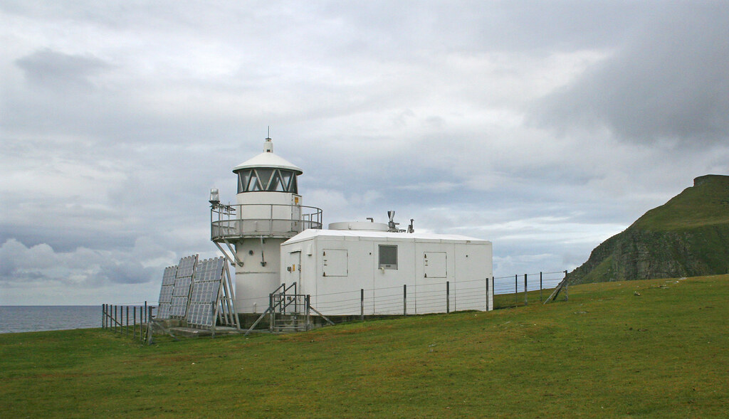
A lighthouse at the southern tip of the island was built in 1986. Originally powered by acetylene gas, it has been converted to solar and wind power.[34]

Culture and the arts

[edit]
Gaada Stack, Foula
Fishing boat off the northern coast of the island

Religion

[edit]

Many inhabitants of Foula attend the Presbyterian Kirk, also known as Baxter Chapel, that is part of the Church of Scotland.[35] It is built of grey stone and is situated "on the tail of 7 Hamnafield".[35]

Film

[edit]
  • Michael Powell's film The Edge of the World (1937) is a dramatisation based on the true story of the evacuation of the last 36 inhabitants of the remote island of St Kilda, on 29 August 1930. St Kilda lies in the Atlantic Ocean, 64 kilometres (40 miles) west-northwest of North Uist in the Outer Hebrides; the inhabitants spoke Gaelic. Powell was unable to get permission to film in St Kilda. Undaunted, he made the film over four months during the summer of 1936 on Foula, where the islanders speak Shetland dialect.
  • Return To The Edge Of The World (1978) is a documentary capturing a reunion of the 1937 film's cast and crew, 40 years later, as they revisit the island.
  • In 2023 Polish writer and director Klaudiusz Chrostowski made a low-budget film Ultima Thule, starring Jakub Gierszał as a 30-year-old man arriving on the island to get over the death of his father. The film was almost entirely shot on Foula and features Arthur Henri, a local inhabitant, in the main supporting role. The film won the Best Micro Budget Film Award at Gdynia Film Festival in 2023.[36][37]

Folklore, festivities and traditions

[edit]

Foula's inhabitants preserve many Norse traditions of folklore and festivities. They still follow the Julian calendar for Christmas celebrations, with all the islanders gathering in one house on 6 January.[38] New Year's Day falls on 13 January.[39]

Poetry

[edit]

Vagaland's poem "Da Sang o da Papa men"[40] about the fishermen of Papa Stour includes an insistent chorus chant, "Rowin Foula Doon".[41] This refers to the fishermen's practice of rowing their open fishing boat out to sea until the high cliffs of Foula were no longer visible. This entailed the boat's being some 96 kilometres (60 mi) west of Papa Stour.[42][43]

Geodesy

[edit]

The Sneug in Foula was the origin (meridian) of the 6 inch and 1:2500 Ordnance Survey maps of Orkney and Shetland.[44]

Notable residents

[edit]
  • Martin Ferguson Smith (b. 1940), scholar and writer.[45] Since retiring in 1995 he has lived in voluntary self-isolation on Foula.
  • Ian Holbourn (1872 – 1935), was Laird of Foula, a professor and lecturer at the University of Oxford, and a writer.
  • Sheila Gear, author of Foula, Island West of the Sun (published 1983 by Robert Hale Limited). She was born in Oxford and studied zoology at Aberdeen University. She married Jim Gear, a crofter, and wrote a book about crofter life in Shetland.[46][47]
  • John Sands (1826–1900) of Ormiston, was a Scottish freelance journalist and artist with an interest in archaeology and folk customs. He spent almost a year on St Kilda and lived on several other remote islands including Foula.

See also

[edit]

References

[edit]

Further reading

[edit]
[edit]
Revisions and contributorsEdit on WikipediaRead on Wikipedia
from Grokipedia
Foula is a remote island located 20 miles west of the Mainland in , recognized as one of the most isolated permanently inhabited islands in the , covering approximately 5 square miles with a population of around 35 residents as of 2025. Its name derives from the Fugla-ey, meaning "bird island," reflecting its abundant populations, including a significant colony of great skuas (formerly the world's largest, though sharply declined since 2022 due to ) and thousands of puffins, guillemots, and fulmars. Geographically, Foula features five distinctive peaks and dramatic cliffs, with Da Kame rising to 1,233 feet (376 meters), one of Britain's highest sheer sea cliffs, alongside unique wildlife such as Foula sheep, Shetland ponies, and a of field mouse. The island's history spans prehistoric settlements from the and Iron Ages, followed by Norse conquest around 800 AD, and it was one of the last places in where the was spoken into the late , with the language becoming extinct in the early . The island was devastated by a smallpox outbreak in 1720. In a nod to its Norse heritage, Foula adheres to the , celebrating Christmas on January 6 and New Year on January 13, differing from the used elsewhere in the UK since 1752. Access is limited and weather-dependent, primarily via a 15-minute flight from near or a 2-hour from Walls on the Mainland, supporting a community economy based on , , , and textiles. Foula's rugged terrain, rich , and strong musical traditions continue to attract visitors seeking its unspoiled natural beauty and isolation.

Etymology

Name origin

The name Foula derives from the Old Norse Fuglaey, composed of fugl meaning "" and ey meaning "," directly translating to "Bird Island." The Scottish Gaelic name is Fughlaigh. This etymology aptly describes the island's prominent colonies, which have long characterized its landscape. In historical records, the name appears in variations such as Fugley or Fughley during the Norse period, reflecting the linguistic influences of Viking settlers who dominated from around the 8th century. Over time, it standardized to the modern form "Foula" by the early , as seen in maps like Willem Blaeu's 1654 chart of and . Foula has also been linked to the mythical of and Roman literature, such as in Pytheas's accounts and Tacitus's Agricola, where it was speculated as a candidate for the northernmost land due to its extreme remoteness in the North Atlantic. This association, though not definitively proven, underscores the island's position at the edge of the known world in classical geography.

Historical references

The earliest documented references to the name Foula appear in medieval Norwegian administrative records, where it is recorded as "Fogle" or "i fogle" in a 1490 land division deed concerning estates. This mention occurs in Diplomatarium Norvegicum volume VIII, document 426, detailing the allocation of properties among heirs of the Norwegian noble Sigurd Jonsson, marking the first known written attestation of the island's name in historical sources. By the early 17th century, the name "Foula" emerges on Scottish cartographic works, notably in Timothy Pont's detailed manuscript maps of surveyed around 1583–1614 and later published. Pont's depiction of includes Foula as a distinct western outlier island, labeled consistently as "Foula," reflecting its integration into emerging Scottish topographic traditions despite the islands' recent transfer from Norwegian to Scottish sovereignty in 1469. In 18th-century , the name's spelling and usage demonstrate notable consistency, as evidenced in George Low's 1774 account of his tour through and . Low, an Orcadian naturalist and clergyman, visited Foula extensively from to August that year, recording the island's name uniformly as "Foula" while documenting local Norn-language ballads and customs, underscoring the persistence of Norse-derived nomenclature in contemporary descriptions. The saw the formal adoption of "Foula" by British surveying authorities, with the incorporating the name into its first-edition one-inch maps of , surveyed between 1856 and 1895. Earlier laird records from estate owners occasionally show minor variations, such as "Fowla," in legal and rental documents, but these did not alter the predominant form used in official mappings.

Geography

Location and extent

Foula is situated in the North as part of the archipelago, with its central coordinates at approximately 60°08′N 02°05′W. It lies about 15 nautical miles (28 km) west of Walls, the nearest point on Mainland Shetland, positioning it as the westernmost island in the group and one of the United Kingdom's most remote permanently inhabited islands. This isolation places Foula roughly 200 miles (325 km) northwest of on the Scottish mainland, emphasizing its peripheral status relative to the broader . The island covers an area of 12.65 km² (1,265 hectares), equivalent to about 5 square miles, and adopts a roughly rectangular form measuring approximately 6 km in length by 4 km in width. Its perimeter forms a compact 13 km coastline, characterized by low-lying eastern shores contrasting with steeper western edges, though the overall extent remains modest within the expansive archipelago. This spatial configuration underscores Foula's bounded yet dramatically positioned presence, 20 miles offshore from the main Shetland landmass in most directional references.

Topography and geology

Foula's topography is characterized by a dramatic contrast between its western and eastern sides, with the island rising steeply from the sea to form precipitous cliffs along much of the west coast, reaching heights of up to 376 meters at The , one of Britain's highest sea cliffs. The highest point on the island is Da Sneug, standing at 418 meters (1,371 feet), situated on a central plateau that forms a broad upland ridge linking several peaks, including The Noup at 248 meters. In contrast, the eastern side features low, broken cliffs and boggy terrain, with gentle slopes descending to the coast, creating a more subdued dominated by peatlands and . Key features include Hamna Voe, a sheltered inlet on the east coast that provides the island's primary natural harbor, and the expansive central plateau known as Da Heights, which separates valleys and supports much of the island's interior drainage. Geologically, Foula is primarily composed of Middle Devonian sandstones belonging to the Foula Sandstone Group, a gently folded sequence approximately 1.6 kilometers thick that unconformably overlies Dalradian metamorphic rocks along the eastern margin. These sandstones, often interbedded with subordinate shales and minor conglomeratic layers, form the bulk of the island's upland and cliff faces, exhibiting a buff to grey coloration and dipping gently at around 25 degrees to the south-southeast. The island's steep escarpments and dramatic western cliffs result from east-west trending fault lines that have facilitated differential , with the sandstones creating resistant dip slopes on the south-facing sides and abrupt north-facing scarps. metamorphic basement rocks, intruded by microgranitic veins, outcrop along the eastern coast, adding to the structural complexity and influencing local coastal topography. Thin glacial deposits from the Pleistocene overlie much of the bedrock, contributing to the boggy eastern lowlands. Land use on Foula reflects its rugged , with approximately 70% of the island's 13 square kilometers dedicated to rough for sheep and ponies, supporting traditional practices on the limited fertile patches. Small areas of are confined to the eastern lowlands near , where improved grasslands allow for hay production and limited crop cultivation, while the central plateau and western uplands remain largely unimproved used for extensive . This pattern underscores the island's reliance on its natural landforms for pastoral agriculture, with the boggy eastern side and steep western slopes limiting intensive development.

Climate

Foula experiences an classified as Köppen Cfb, characterized by mild temperatures, high humidity, and frequent precipitation influenced by its North Atlantic location. The annual average temperature is approximately 7.8°C (46°F), with mean daily highs ranging from 6°C (42°F) in to 13°C (56°F) in and lows from 2°C (36°F) to 10°C (50°F) during the same period. Winters remain mild, with temperatures rarely dropping below 0°C due to the moderating effect of the , while summers are cool and seldom exceed 15°C on average. These patterns reflect the island's exposure to maritime air masses, resulting in limited seasonal variation compared to mainland . Precipitation is abundant, averaging around 1,250 mm annually, with the majority falling during autumn and winter months when Atlantic depressions bring persistent . , for instance, typically sees over 130 mm of rainfall, contributing to about 5-6 rainy days per week on average throughout the year. This wet regime supports lush vegetation but can lead to waterlogging in low-lying areas. Foula's also features strong , with average speeds of 20-25 km/h year-round, escalating to gales (sustained winds over 17.2 m/s) on more than 50 days annually—higher than the 53 gale days recorded at nearby due to the island's westerly position. Extreme gusts have reached 173 mph in recorded events, underscoring the island's vulnerability to North Atlantic storms. The island exhibits distinct microclimates, with the exposed western cliffs enduring relentless westerly gales and salt spray, while the eastern side, where most settlement occurs, benefits from relative shelter provided by the island's . This contrast affects local conditions, making the east slightly drier and less windy. Notable storms, such as severe gales in the late , have occasionally delayed services, isolating the community for days. These weather patterns influence practices by limiting growing seasons and increasing risks, though the mild temperatures enable year-round .

Transport

Access to Foula is primarily provided by and air services from the Mainland, with limited internal transport options due to the island's remote and rugged nature. The main sea connection is the inter-island service operated by BK Marine using the vessel M/V New Advance, which sails from Walls on the Mainland to the pier at on Foula. This foot-passenger-only service runs twice weekly during winter, increasing to three times per week in summer, with each crossing taking approximately two hours. The vessel has a capacity of 12 passengers and is subject to weather conditions, which can lead to cancellations. Air travel offers a faster alternative, with scheduled flights operated by Airtask from Foula Airstrip to near . These services run up to 11 times per week, averaging about two flights per day, and take around 15 minutes, though they are highly weather-dependent and may be canceled due to strong winds or poor visibility. On the island, there is no public bus service, and movement relies on a network of approximately 6.5 km of single-track public roads, supplemented by 1.22 km of private roads. Local residents often provide informal to the airstrip or by arrangement, while remote areas are accessed by walking or trails. Prior to the , internal travel and connectivity were predominantly by , given the lack of developed road infrastructure.

Demographics

Foula's has undergone significant fluctuations over the centuries, reflecting the challenges of its remote and economic pressures. Historical indicate that the island's population peaked at 267 by the end of the , driven by subsistence farming and activities that temporarily supported a larger community. However, this growth proved unsustainable, leading to a sharp decline beginning in the early due to widespread as residents sought better opportunities on the mainland and abroad. A pivotal event in Foula's demographic history was the 1720 smallpox epidemic, which devastated the island by wiping out more than 90 percent of its inhabitants, leaving few survivors to bury the dead and severely hindering recovery for generations. Subsequent population stagnation and decline were exacerbated by ongoing , an aging demographic with low birth rates, and the limited economic viability of in such isolation. By the mid-20th century, the population had fallen below 100, continuing a trend of gradual erosion seen across many Scottish islands. In recent decades, Foula's population has stabilized at a low level, with community data showing around 35 residents as of 2023. As of 2025, the population remains around 35. The community remains predominantly composed of families, with a near-even balance mirroring broader demographics of roughly 50.7 percent male and 49.3 percent female. In 2024, efforts to recruit a full-time district nurse highlighted ongoing attempts to address service gaps and potentially attract new residents to sustain the population.

Community and services

Foula is administered under the , which oversees local governance and development priorities for remote islands including Foula. meetings and events are held at the island's combined and , opened in 1992 and used for social gatherings, exhibitions, and visitor receptions. There is no resident police presence, with policing services provided from the Shetland mainland by as required. With a population of approximately 35, Foula maintains a tight-knit centered on mutual support among residents. is delivered through Foula , a small typically serving up to 5 pupils from primary through nursery levels, where the handles all instruction in a single-teacher setting. Healthcare on the island relies on outreach from NHS Shetland, including weekly doctor visits from the mainland health center in Walls and booked or walk-in appointments with a nurse. In 2024, NHS Shetland advertised a full-time district nurse/ position for Foula at Band 6, offering a salary range of £37,831 to £46,100 to provide comprehensive to residents and visitors. Among notable figures associated with Foula, served as the island's from around 1900, while also acting as a professor and lecturer at the . Martin Ferguson Smith, an emeritus professor of classics at specializing in , has lived in voluntary self-isolation on Foula since 1995, continuing his scholarly work there. Living residents, particularly crofters active in Foula Heritage—a community group founded in 2000—contribute to heritage preservation through part-time ranger services, cultural recordings, and environmental initiatives focused on the island's unique wildlife and traditions.

Economy

Agriculture and crofting

Agriculture and crofting form the backbone of Foula's land-based economy, with the island's approximately 1,265 hectares largely divided into small holdings managed by the resident population. on Foula emphasizes sustainable, low-input farming adapted to the rugged terrain, where most land is common grazing used for livestock rather than intensive cultivation. The dominant activity is , centered on the indigenous Foula sheep, a strain of unmodernized known for their hardiness, ability to thrive on sparse hill pastures, and naturally colorful fleeces in shades such as white, black, moorit (reddish-brown), and shaela (dark grey). These sheep occasionally exhibit multi-horned rams with two or four horns, a trait linked to their Norse-influenced heritage, and their fleece provides elasticity, loft, and water repellency suited to the island's severe weather. Crofters practice natural breeding without imports, preserving , and manage flocks on the hills with minimal intervention, clipping fleeces annually for production. Other agricultural pursuits are limited by the thin, acidic peaty soil and exposure to high winds, restricting crop growing to small-scale efforts in protected plantie crubs—stone-walled enclosures. Potatoes, particularly the rare Foula Red variety with pink-red skin, pale yellow flesh, and blight resistance, are cultivated in low yields of four to five tubers per plant, serving as a vital self-sufficiency crop despite the challenges. Shetland ponies also play a supporting role, living semi-ferally on the hills to monitor weather patterns and assist indirectly in sheep herding by signaling conditions for rounding up flocks; mares return to crofts for foaling and supplemental feed. Fishing, once significant, now contributes minimally to the agricultural economy. Yields across all activities are highly weather-dependent, with gales exceeding 100 mph and a short often reducing productivity and increasing risks to . To mitigate economic pressures, crofters receive support through schemes, including the Crofting Agricultural Grant Scheme (CAGS), which funds up to 80% of improvements like infrastructure, and targeted investments such as the 2022 grant for a local mini-mill, established in 2024, to process on-site using . Income derives from annual sales of —now value-added as yarns sold online and at events like Shetland Week—and lambs exported to the Shetland Mainland, helping sustain the system amid fluctuating markets.

Tourism and other activities

Foula's tourism revolves around its rugged natural features and rich avian life, drawing visitors to explore the island's unspoiled environment. Prominent attractions include cliff walks along Da Kame, one of Britain's highest sheer sea cliffs at 1,233 feet (376 meters), and expansive bird colonies that host tens of thousands of seabirds such as , , , and great skuas during the breeding season. The island's dramatic coastline, including formations like the Gaada Stack sea arch and the Sneck o da Smallie fissure, further enhances its appeal for those seeking solitude and scenic vistas. Visitor numbers remain modest, primarily consisting of birdwatchers and nature enthusiasts who arrive in peak summer months when wildlife activity is highest. Access via ferry from Walls or short flights from on the Mainland enables both day trips and extended stays, though weather-dependent schedules limit overall volume. Activities emphasize outdoor immersion, with guided hikes offered by the Foula Ranger Service providing educational tours of the cliffs, moors, and local flora like sea pinks and wild orchids. Self-guided walks are also available through resources from Foula Heritage, allowing exploration of the island's 5-square-mile terrain at one's own pace. Accommodations are sparse and cater to a low-impact experience, including self-catering options at Ristie, which sleeps up to eight guests, and The Burns , alongside designated sites. Occasional fishing charters, such as those by Shetland Sea Adventures, offer tours around the island's western cliffs for marine observation. Supplementary income sources include artisanal crafts, notably Foula Wool, which produces small-batch, naturally colored yarns from the wool of the island's distinctive four-horned sheep, marketed to support local enterprise. Additionally, efforts hold potential for economic diversification; in 2024, the Foula Electricity Trust upgraded its inverters with funding through the Community and Renewable Energy Scheme, bolstering the island's off-grid power system and advancing net-zero goals. Tourism and these ancillary activities form a key pillar of the local economy, complementing traditional sectors by providing essential revenue for the community of around 35 residents as of 2025.

History

Prehistory and early settlement

Archaeological evidence suggests that Foula was first settled during the period, around 5,000 years ago, as part of broader human occupation across the archipelago. While specific artifacts from this era on Foula remain elusive, geophysical surveys have identified potential early settlements, including ditched enclosures and burnt mounds near Harrier, indicative of small-scale farming communities adapting to the island's rugged terrain. The , dating to approximately 3,000 years ago, provides clearer traces of human activity through monumental constructions. At Da Heights on the northern ridge, two concentric egg-shaped stone rings—comprising around 290 low stones in total—were erected, with the inner ring measuring about 45 meters by 40 meters and the outer 70 meters by 60 meters. These alignments, oriented toward the midwinter sunrise at a bearing of roughly 140 degrees, suggest significance tied to solar observations, supported by mid- sherds and samples revealing a landscape with and trees. A damaged near Harrier may represent a contemporary feature, pointing to organized small communities focused on ceremonial and funerary practices. Before the Norse colonization around the 8th century, Foula was likely inhabited by Pictish groups, the indigenous people of northern who occupied during the early historic period. However, direct evidence of Pictish presence on the island is limited, hampered by the absence of written records and the challenges of excavation in such a remote, peat-covered environment; broader findings, such as symbol stones and inscriptions elsewhere in the , imply cultural continuity but offer no confirmed links to Foula itself.

15th to 19th centuries

Foula's Norse heritage persisted well into the post-medieval period, with the island remaining under Norwegian control until the late . Norse settlers had established communities on Foula around the 8th or , integrating it into the Viking world that extended from to the North Atlantic. The islands, including Foula, were pledged to in 1468–1469 as part of a dowry for the marriage of Norwegian princess to King James III, and formally annexed to the Scottish crown in 1472, marking the end of direct Norse rule. Despite this transition, Norse cultural influences endured, notably in the , a descendant of spoken on Foula as "Da Dansk" and one of the last strongholds in until the . The was still recited in Norn in Foula's at the end of the , reflecting the slow linguistic shift to Scots and English. Lairdship of Foula evolved through Scottish ownership following , with the island passing to Norwegian noble Alv Knutsson in 1490 before Scottish families took control. By 1572, it had been transferred to Robert Cheyne, a Scottish landowner, ending centuries of Norse estate management. In the , the Scott family of Melby and Gibliston acquired Foula along with nearby Vaila through inheritance in 1736, with John Scott serving as laird from around 1700 until his death in 1765.[](https://portal.historicenvironment.scot/apex/f?p=1505:300:::::VIEWTYPE,VIE WREF:designation,LB18630) Under Scott lairdship, the island's isolation shaped governance, emphasizing subsistence farming and limited external ties. A devastating epidemic in 1720 decimated Foula's population, which stood at approximately 200 prior to the outbreak, reducing it to just six survivors due to the islanders' lack of immunity from their remote location. This event, part of recurring plagues in the amid famines, left the dead unburied by many, underscoring the vulnerability of isolated communities. The survivors, aided by new families from the Shetland Mainland, repopulated the island over subsequent decades. In the , Foula avoided the widespread clearances that affected much of the and Islands, as its small scale and laird-managed tenancies preserved traditional holdings averaging 2–2.5 hectares per croft. recovery led to growth, reaching 267 by the late , supported by despite challenging conditions from high winds and salt spray. The island's exposed position in the North Atlantic contributed to frequent shipwrecks throughout the century, with salvage from these incidents providing economic relief and foreshadowing major maritime losses in the surrounding waters.

20th and 21st centuries

In the early , Foula gained international attention due to maritime disasters and cultural depictions. On September 8, 1914, the RMS Oceanic, a ocean liner and sister ship to the Titanic, ran aground on the Shaalds o' Foula during foggy conditions while serving as an armed merchant cruiser; all 600 crew members were rescued by local islanders and vessels, though the ship became a total wreck. In 1937, director filmed The Edge of the World on Foula, using the island's dramatic cliffs and isolation to portray the decline of a remote community, inspired by the evacuation of St Kilda; the production, which lasted four months, introduced Foula to global audiences and highlighted its rugged beauty. During , Foula's strategic North Atlantic position contributed to Shetland's broader defense efforts, including observation roles amid increased naval and air activity in the region. By the mid- to late , Foula experienced significant depopulation amid broader socioeconomic shifts in . The 1970s North Sea oil boom reversed across the Shetland Mainland through job opportunities, but Foula's remoteness led to , particularly of young residents seeking work; the island's population fell from around 80 in the early to about 40 by the . To mitigate isolation, a airstrip was constructed and opened in 1969, enabling regular flights from on the Shetland Mainland and improving access for residents and supplies. Ownership of the island remained with the Holbourn family, who had acquired it around , maintaining traditional oversight into the late without major changes. In the , Foula has focused on and visibility through media and support. The 2023 Polish film Ultima Thule, directed by Klaudiusz Chrostowski, was partially set and filmed on Foula, following a protagonist's journey to the island for solace after personal loss, further elevating its profile as a symbol of remoteness. A lighthearted dispute emerged in 2024 between Foula and residents over the title of Britain's most remote inhabited island, sparked by media claims favoring Fair Isle; Foula's advocates emphasized its 14-mile distance from the nearest land and lack of visual connection to the mainland. Under Scotland's National Islands Plan, launched in 2019 and updated through 2025, Foula has received funding for infrastructure improvements, including enhancements to transport links and community facilities to support its small population of around 30-40 and promote long-term viability.

Culture

Religion and calendar

Foula's religious community is predominantly Presbyterian, centered on the island's single church, Baxter Chapel, constructed in the late as an independent Congregationalist . The chapel, built of local grey stone and located above the airstrip near , replaced an earlier structure at the Ayre of Ham and was funded by a gift from the sisters of Dr. William Baxter in his memory. Originally established under the influence of the Haldane brothers' Congregationalist teachings in 1817, it transitioned to maintenance by the , though it has lacked a resident minister since 1990, with services now conducted occasionally—up to six times annually—by visiting clergy from the Mainland. The chapel's ownership was transferred to Foula Heritage in 2021 on behalf of the community for preservation, reflecting the island's small population of around 36, which supports no other resident denominations. The island's unique calendrical practices are tied to its religious heritage, as Foula retains the for feast days despite adopting the for civil matters in 1901. This results in , known locally as , being observed on January 6 and , or Newerday, on January 13, placing these celebrations 12 days behind the standard Gregorian dates. The tradition originated in the 18th century, when Foula resisted the 1752 Calendar Act that aligned with the Gregorian system introduced by in 1582 to correct astronomical inaccuracies in the ; the island's remoteness and commitment to older customs preserved the Julian reckoning for religious purposes. In 2025, Foula's Julian New Year on January 13 was marked by community gatherings emphasizing family and tradition, including first-footing—where residents visit homes bearing gifts like whisky or for good luck—followed by music sessions and a late-night party that extended into the early hours. These observances underscore the island's cohesive social fabric, with participants performing minor tasks such as gathering or tending crofts on the day itself to ensure prosperity, blending practical island life with spiritual continuity.

Traditions and folklore

Foula's traditions reflect its deep Norse roots, particularly in seasonal celebrations that blend ancient customs with community gatherings. observances, held on January 6 per the , include house visits for and . The island's on January 13 features a communal party, with residents gathering for , , and house-to-house visits to usher in the year, often incorporating small luck-bringing rituals like collecting from the shore. Folklore on Foula draws from Shetland's rich oral heritage, featuring tales of selkies—mythical seal-people who shed their skins to assume human form on land, often weaving stories of forbidden romances and sea-bound longing. Narratives of trows, diminutive troll-like beings that dwell in the hills and mischief during twilight hours, warn of their tricks on unwary travelers and crofters. Superstitions linger around the island's dramatic cliffs and history of shipwrecks, including eerie happenings at Da Lum a Liorafield, where speaks of lost entrances and otherworldly presences, and beliefs in the curative powers of waters like Da Watter ida Sneug near treacherous shores. Contemporary festivities maintain these communal bonds through practical seasonal events. The annual sheep clipping in July unites islanders in a collective effort to shear the primitive Foula strain of , using traditional rooing methods in community-built fanks during dry weather, preserving Norse-influenced husbandry practices. Foula's 2025 events on January 13 garnered media spotlight for their enduring customs, drawing attention to the island's isolation and cultural resilience.

Arts, literature, and film

Foula has been depicted in early cinema through Michael Powell's 1937 The Edge of the World, which was shot entirely on location on the island to capture its rugged isolation and community tensions, loosely inspired by the evacuation of St Kilda but adapted to Foula's Norse-speaking environment. The production involved local residents as extras and highlighted the island's dramatic cliffs and harsh weather, contributing to Powell's reputation for authentic location shooting. In more recent media, the 2023 Polish drama Ultima Thule, directed by Klaudiusz Chrostowski, features Foula as the primary setting for a story of personal redemption, where the relocates to the following his father's death, emphasizing its remoteness and natural challenges. The film portrays daily life amid Foula's colonies and windswept landscapes, drawing parallels to earlier cinematic visits like Powell's while exploring themes of and renewal. Literature has also captured Foula's essence through Shetland poet Christine De Luca, whose works in Shetlandic and English often evoke , including specific references to Foula in poems like "Time Circles," which reflects on its coastal vistas and cyclical rhythms. De Luca's poetry, such as in collections like Parallel Worlds, draws from her roots to portray the interplay of heritage and environment on remote isles like Foula, blending personal observation with to convey a sense of enduring connection. Foula's cultural output extends to music, where folk traditions are enriched by the island's populations; tunes like "The Foula Reel" and songs such as "Rowin' Foula Doon" evoke the maritime and avian sounds of the cliffs, performed during events like Foula Fest that celebrate local heritage. These compositions, rooted in Shetland's and styles, often incorporate the island's natural , including calls, to underscore themes of resilience and place.

Environment

Wildlife

Foula's flora consists primarily of heathy grasslands and maritime vegetation resilient to the island's exposed, windy conditions. The absence of trees is attributed to the relentless gales that sweep across the island. Maritime cliffs support thrift (Armeria maritima) and sea campion (Silene uniflora), which form colorful carpets alongside short grasses in the saline environment. Inland moorlands feature boggy habitats with cottongrass, crowberry, and sundew, interspersed with patches of tormentil and vernal squill that add seasonal vibrancy to the landscape. The island's is dominated by approximately 250,000 (as of the 1990s) that utilize its cliffs and slopes for nesting. Endemic Foula sheep, prized for their hardy nature and multicolored fleeces, roam freely alongside semi-wild ponies. Otters inhabit freshwater lochs and streams, while and common seals haul out in the sheltered voes along the coastline. Recent monitoring indicates declines in populations overall, though site-specific data for Foula remains limited. Wildlife activity follows distinct seasonal patterns, with breeding colonies reaching their peak from May to July during the long daylight hours. Migration periods, particularly in spring and autumn, offer opportunities to observe transient passing through Foula's strategic position in the North Atlantic. The island's varied , from sheer cliffs to coastal inlets, underpins this .

Conservation

Foula holds the designation of an Important Bird and Biodiversity Area (IBA) from , recognizing its global importance for the conservation of populations, including large colonies of (2,170 breeding pairs as of 1992), , and (48,000 breeding pairs as of 1987). The island is further protected as a (SSSI) through two overlapping designations: the Foula SSSI, which safeguards the extensive and associated habitats supporting diverse and , and the Foula Coast SSSI, which preserves the dramatic coastal cliffs and breeding grounds (assessed as mostly unfavourable and declining as of 2000–2007). These protections extend to the surrounding waters via the Seas off Foula (SPA), focusing on marine habitats critical for foraging . Key threats to Foula's include , which disrupts breeding through altered ocean temperatures affecting prey availability and increased storm frequency impacting nest sites. , such as non-native plants and mammalian predators including feral cats, rats, and hedgehogs, exacerbate pressures by competing with or preying upon endemic and , necessitating ongoing control measures to maintain ecological balance. Conservation management involves regular monitoring by the Shetland Bird Club, which tracks populations and migrant sightings on Foula to inform adaptive strategies amid environmental changes. Community-led initiatives, including Foula Heritage's guidelines, promote by encouraging low-impact practices such as sticking to paths, respecting distances, and minimizing waste to reduce disturbances from increasing numbers. These efforts help balance ecological preservation with limited economic benefits from tourism.

Geodesy

Coordinates and extent

Foula is situated at central coordinates of 60°08′N 2°05′W, corresponding to the reference HT 954 387. The island's extent covers approximately 13 km², spanning latitudes from 60°04′N to 60°11′N and longitudes from 2°12′W to 1°57′W. These positional data are referenced to the OSGB36 datum underlying the British National Grid system. Foula's surrounding extend 12 nautical miles from the low-water baseline encircling the island, forming part of the United Kingdom's territorial as defined under national legislation. These waters were integrated into the European Union's maritime boundary framework for and until the UK's withdrawal in 2020, with specific exclusions applied in EU quota regulations for zones within 6 nautical miles of Foula's baselines. Post-2000 advancements in geodetic measurement have included GPS validations of Foula's coordinates, culminating in Ordnance Survey's 2017 custom mapping project that incorporated the island into Great Britain's digital national dataset using contemporary satellite-based surveying techniques.

Trigonometrical significance

Foula's trigonometrical significance stems primarily from The Sneug, its highest peak, which served as a key in the Ordnance Survey's mapping of northern . Established in the as part of the efforts for and , The Sneug functioned as the origin meridian for the county series maps of these regions, including the 6-inch and 1:2500 scales. This role was critical for establishing a stable reference point in the remote northern , enabling accurate angular measurements across the islands. The station's height is recorded as 418 meters above , providing an elevated vantage for line-of-sight observations essential to the survey's methodology. As a foundational element in the British triangulation network, The Sneug supported the creation of maps for northern , forming the basis for detailed topographic representations of and during the late . Its position allowed surveyors to extend measurements from mainland baselines northward, integrating Foula into the broader geodetic framework. In the , the station contributed to revisions of these maps, with the original mark supplemented by a trig pillar constructed during the Retriangulation of (1935–1962), enhancing precision for updated national mapping. This integration ensured consistent coordinate systems across 's coastal and island territories. The enduring legacy of The Sneug lies in its contribution to the United Kingdom's national geodetic framework, where its stable position has required minimal adjustments in modern GPS-era transformations. Retained as a fundamental benchmark in archives, it exemplifies the reliability of early points in supporting contemporary geospatial applications, from to . Its isolation on Foula underscores the challenges and ingenuity of 19th-century in Britain's extremities.

References

Add your contribution
Related Hubs
User Avatar
No comments yet.