Respect all members: no insults, harassment, or hate speech.
Be tolerant of different viewpoints, cultures, and beliefs. If you do not agree with others, just create separate note, article or collection.
Clearly distinguish between personal opinion and fact.
Verify facts before posting, especially when writing about history, science, or statistics.
Promotional content must be published on the “Related Services and Products” page—no more than one paragraph per service. You can also create subpages under the “Related Services and Products” page and publish longer promotional text there.
Do not post materials that infringe on copyright without permission.
Always credit sources when sharing information, quotes, or media.
Be respectful of the work of others when making changes.
Discuss major edits instead of removing others' contributions without reason.
If you notice rule-breaking, notify community about it in talks.
Do not share personal data of others without their consent.
Monemvasia (Greek: Μονεμβασιά, Μονεμβασία, or Μονεμβάσια) is a town and municipality in Laconia, Greece. The town is located in mainland Greece on a tied island off the east coast of the Peloponnese, surrounded by the Myrtoan Sea. Monemvasia is connected to the rest of the mainland by a tombolo 400 metres (1,300 ft) in length.[2]
In 1890, a small part of the natural tombolo was cut to create an artificial bridge for ships and boats.[3] Its area consists mostly of a large plateau some 100 m (330 ft) above sea level, up to 300 m (980 ft) wide and 1 kilometre (0.62 mi) long.
Founded in the sixth century, and thus one of the oldest continually-inhabited fortified towns in Europe, the town is the site of a once-powerful medieval fortress, and was at one point one of the most important commercial centres in the Eastern Mediterranean. The town's walls and many Byzantine churches remain as testaments to the town's history. Today, the seat of the municipality of Monemvasia is the town of Molaoi.[4]
The town's name derives from two Greek words, moni (μόνη, 'single') and emvasis (έμβασις, 'approach'), together meaning city of the "single approach, or entrance". Its Italian form, Malvasia, gave its name to the eponymous wine. Monemvasia has been nicknamed "the Gibraltar of the East" (Γιβραλτάρ της ανατολής).[5][6]
The island on which the town of Monemvasia is situated may have been the site of a Minoan trading post. Pausanias, the renowned Greek traveler and geographer, referred to the site as Akra Minoa, which translates to "Minoan Promontory".[7] The ancient settlement of Epidaurus Limera was located a little north of Monemvasia in ancient times. The region surrounding the two settlements has been inhabited since prehistoric times. During Roman times it flourished as the most important city on the eastern coast of the Malea peninsula.[8]
Pausanias visited Epidaurus Limera and said that opposite the city there was a promontory which he referred to as the "extremity of Minos", which has been identified as Monemvasia. Strabo—a century earlier—mentions it as "Minoan fortress". The toponym "Minoa" indicates the existence of a port in antiquity, traces of which have been discovered underwater. However, it is not known if there was a significant settlement on the island. It is possible that a settlement was established there in the 4th century, around the time when the capital of the Roman Empire moved from Rome to Constantinople, which resulted in changes in maritime trade routes. Epidaurus Limera itself was abandoned in the 4th century.[9]
Monemvasia was founded in the 6th century, from the relocation of the inhabitants of Ancient Sparta, which was then known as Lacedaemon. Sparta, unlike other cities that were abandoned, continued to be inhabited until the 6th century AD, despite earthquakes, Goth raids in 395 under Alaric I and Vandals in 468 under Gaiseric, and the plague epidemic of 541-543.[9] According to the later Chronicle of Monemvasia, the city was abandoned after a Slav raid in 587-588, during the reign of Maurice. The Chronicle reports that its inhabitants left Sparta in panic and fortified themselves under the leadership of their bishop in Monemvasia while others settled in the passes of the region, while mentioning that many other cities of the Peloponnese were also abandoned in this way.[9] However, archaeological findings do not generally concur with this view, and place the foundation of Monemvasia a few decades earlier, during the reign of Justinian. The first level of the basilica church of Christ Elkomenos in the center of the lower town dates from that time.[9]
During Justinian's reign, due to various disasters, either natural factors or raids, the cities experienced significant decline. Justinian proceeded with residential remodeling, moving entire cities' populations to new locations and often changing the city's name. Such changes are mentioned by Procopius in On Buildings, though specific references to the Peloponnese are rare.[9]
The 15th century text Report to the Patriarch, written by Isidoros, the metropolitan of Monemvasia, mentions that the movement of the population took place under Justinian. Another city that moved in the same period was Aipeia in Messenia, which moved to the current site of Koroni. Similarly, the location of Sparta was deemed insufficiently fortified and prone to long-term blockades due to its long distance from the port, while with the move of the capital to Constantinople, ships from Gytheion now had to sail around Cape Maleas.[9]
Due to the aforementioned reasons, the city authorities proceeded not only to move the population of Sparta, establishing Monemvasia, but also to reorganize the settlements of southeastern Laconia. The reorganization included settlement in the mountain passes of Parnon and the migration from Gytheion. The Chronicle of Monemvasia states that part of the population relocated as far away as Sicily. Because the rebuilding, moving, and settling of the population at the new location must have been completed several years later, it is likely that the two cities coexisted for some time. Along with the inhabitants, the seat of the diocese of Lacedaemonia was also moved, although it kept its old name.[9]
Unlike other settlements in the Peloponnese region that saw their decline from the 7th century onwards—a period known as the Dark Ages—Monemvasia developed into a commercial and cultural centre due to its location on important sea routes, such as the one that connected it to Sicily. A bronze coin minted in Sicily of Philippikos Bardanes was found in the lower town. The oldest known mention of Monemvasia dates from the third decade of the 8th century, and is made by the pilgrim Vilibaldos, who traveled from Sicily to the Holy Land with a stopover in Monemvasia. Monemvasia is also mentioned by Theophanes the Confessor, who describes the arrival of the plague in Byzantium in 746-747.[9]
The central square of Monemvasia, with the Byzantine church of Christ Elkomenos.
Monemvasia's key position on the sea route to the eastern Mediterranean made it the target of pirate raids in the following centuries, along with raids by Western rulers. Arab raids began in the 9th century and after their settlement in Crete, after which the raids multiplied. One such raid is mentioned in the so-called Psychophile Narratives of bishop Pavlos Monemvasias, which were written in the 10th century and survive only in an Arabic translation. In one of them, it is mentioned that the Arabs attacked the fortress of Vukolo, which has been identified as Monemvasia.
Earlier in the same text it is mentioned that the relics of the saints of Barcelona—of Bishop Valerius, Eulalia and Vincentius among others—had washed up in the city. The inhabitants collected the sarcophagi that contained them and built a church on the steep hill. Later, after the landing, it is reported that during the reign of Emperors Leo VI and Alexander, the chapel was located and the remains were transferred to the chapel of Agia Irini, next to the church of Agia Anastasia (which today is dedicated to Christ Elkomenos).
At the beginning of the 10th century, the ecclesiastical seat of Monemvasia was transferred from the jurisdiction of the church of Rome to the patriarchate of Constantinople, where it was demoted to the diocese of Corinth. Despite this, Monemvasia continued to develop, while at the same time maintaining privileges, among which was self-government.[9]
During the 11th and 12th centuries, Monemvasia experienced significant economic growth. During that period, the settlement spread around the island (not only on its main side), and important monuments were rebuilt, such as the church of Hagia Sophia (originally dedicated to Panagia Hodegetria) in the upper town and the church of Elkomenos Christos, which was reconstructed during that period, possibly due to the placement of the image of Christ Elkomenos in the temple. At the time of the Komnenians, Monemvasia had evolved into a guardian of the western entrance to the Aegean. In 1147 ships of the Sicilian king Roger II tried to capture it without success and were forced to withdraw with heavy losses. The archon of Monemvasia during the attack Theodoros Mavrosomis then settled in the imperial court and after the Battle of Myriokephalos, he was put in charge of the left wing of the army and was then given the position of mediator.[9]
The Latin Empire, a 13th-century crusader state, unsuccessfully besieged Monemvasia in 1222. Then, in 1252, after a three-year siege, the Frankish prince of Achaia, William of Villehardouin, occupied Monemvasia. The inhabitants of Monemvasia who did not wish to remain under Latin occupation left for Bithynia, which acquired many of the same commercial privileges as Monemvasia.[10] Monemvasia itself retained the privileges it had, with the only obligation being maintenance of the ships, and became the seat of a Latin bishop.[9] Its loss was a serious blow to the emperor of Nicaea, Michael VIII Palaiologos, as it overturned his plans for the recovery of the lands that had fallen to the Franks.[citation needed]
When William was captured by the Byzantines at the Battle of Pelagonia in 1259 and refused to cede his possessions in the Peloponnese in exchange for his release, Michael held him prisoner until 1262, when he agreed to surrender to the Byzantines the castles of Monemvasia, Mystras, Grand Magne, and Geraki. Monemvasia was designated the seat of a Byzantine general and the seat of an Orthodox metropolitan, while at the same time important privileges were granted to the inhabitants, which were renewed and expanded by Andronikos II Palaiologos (1282-1328), such as exemption from inheritance tax and exemption from commerce (duties). Andronikos III Paleologos then exempted Monemvasia from 28 taxes. The prosperity of the city was rapid: in addition to the increase in population, whose main achievement was trade and shipping, conditions were created for spiritual and ecclesiastical development, to the extent that the period up to 1460 is considered to have been the city's "golden age". This prosperity attracted Roger of Lauria, who sacked the lower town in 1292. In 1302, the town welcomed the Catalan Company on its way eastward. In 1324, out of a total of 3,108 pyres that the metropolitans contributed to the Constantinople Patriarchate, 800 came from the Monemvasia metropolis, more than any other. In 1347 or 1348, John VI Kantakouzenos promoted the metropolis of Monemvasia to the hierarchy of the Patriarchate of Jerusalem. The peaceful life of Monemvasia during the 14th and the first half of the 15th century was disturbed by pirate raids and internal conflicts, though they did not, however, affect its historical course under the Despotate of the Morea.
In 1354, control over the Despotate of Morea was usurped by Manuel Kantakouzinos, who remained in power until 1380. The administration of Monemvasia was given to Ioannis Kantakouzinos, who rebelled after learning that after Manuel's death, Theodore Palaiologos would be appointed. Theodore tried to approach Monemvasia but was driven away and fled to Venetian-occupied Koroni to ask for help in exchange for the territory of Monemvasia, but the Monemvasians repudiated the rebels. In 1394, Theodore was captured by Ottoman Sultan Bayezid I and, in order to free himself, asked for the surrender of Monemvasia. Theodore managed to escape and with the help of Venice recaptured Monemvasia from the Ottomans in July 1394. The result of all these events was that the city's population decreased and commercial traffic was effectively brought to a halt.[9]
After the fall of Constantinople in 1453, unrest prevailed in the Despotate, which at the time had two despots, Thomas Palaiologos and Demetrios Palaiologos, who disagreed about the future of the despotate. Dimitrios surrendered Monemvasia in May 1460 to Mehmed II, but he withdrew without besieging it. Then, following the advice of Thomas, the inhabitants offered the city to Pope Pius II on September 12, 1460, who accepted.[9]
In 1460 Sultan Mehmed II arrived in Corinth, proceeded to Laconia, capturing the fortresses of Achaia and Ilia, and in July 1461, Salmenikos, the last castle of the Greek despot, was surrendered. Thus, apart from the Venetian possessions of the Peloponnese and Monemvasia, which had been granted with the consent of the Despot of Morea Thomas Palaiologos to Pope Pius II, the Ottoman conquest of this critical region for Byzantium was complete. By the end of 1463, Monemvasia had fallen to the Venetians. After the end of the First Ottoman-Venetian War (1463–1479), part of the lands in the territory of Monemvasia came under the possession of the Ottomans, affecting the island's agricultural production and trade. Venice's possessions around Monemvasia became more limited after the Second Ottoman-Venetian War (1499–1503).[9]
Hayreddin Barbarossa began in 1537 attempts to capture Nafplio and Monemvasia, the two remaining Venetian possessions in the Peloponnese. In the peace treaty, Sultan Suleiman II requested as compensation for the damages suffered by the fleet the concession of islands he has conquered along with Nafplio and Monemvasia, and despite the Venetians' reactions, the treaty was signed on October 2, 1540, and the two cities surrendered to the Turks. Most of its inhabitants then abandoned it and took refuge in the nearest Venetian-occupied islands, mainly in Corfu and Crete.
During the Ottoman times, the upper town was abandoned. Monemvasia itself became known as Menexe (Μενεξέ), Menefse (Μενεφσέ), or Benefse (Μπενεφσέ) in Greek and Menekşe in Turkish (all meaning 'violet'). It was administratively included in the Eyalet of the Morea. In the census of 1573-1574, it was mentioned that the town had a garrison of 104 men and paid 28,665 akçes in taxes, 6,000 of which came from the commercial traffic in its port. Due to information that there was a small garrison in Monemvasia, Jean Parisot de La Valette, the Grand Master of the Order of Malta decided to capture it in order to obtain a base in the Aegean. At the end of September 1564, he sent galleys but as the old unguarded path leading to the upper town could not be located, they withdrew. This path was sealed by the Ottomans sometime later with a wall. In 1583 there were 320 non-Muslim families and 191 residents without a family.[9]
During the Cretan War (1645–1669), attempts were made by Venice to capture Monemvasia, which served as a base for the Ottoman army. The first attempt was made in August 1653, in which the Venetians managed to capture a fort outside the lower town, but abandoned the attempt as attacks on the lower town failed. The second attempt was made in July 1655, with the Venetians proceeding to blockade Monemvasia, but as the Ottomans sent reinforcements, they eventually withdrew. Subsequently, the Ottomans strengthened the defense of the island, and granted its inhabitants the possibility to build a church with a dome, as a reward for not ceding the city to the Venetians.[9]
In 1684, the Sixth Ottoman–Venetian War began, during which Francesco Morosini occupied the entire Peloponnese, with the exception of Monemvasia, which resisted. Morosini besieged it again in 1687, bombarding it, but the Turkish defenders refused to surrender and he withdrew. Many Turks who fled from the rest of Moria took refuge in the city. In 1688 he proposed to build a fortress opposite Monemvasia. Finally in July 1689 the construction of two forts began and the siege began again, but it was again unsuccessful and at the end of September it was withdrawn. At the end of the following spring the siege was resumed, led by Girolamo Corner and despite setbacks, the city surrendered and Corner entered on 12 August 1690.[9]
The recovery of the Peloponnese from the Venetians also resulted in the resettlement of residents in Monemvasia, which was designated as the capital of the department of Laconia. The city had suffered significant damage and began a program of reconstruction. Its population in 1700 had reached 1,622 inhabitants, almost double the count of ten years prior.[9]
In 1715, the Ottoman Empire army attacked the Peloponnese, in the context of the Seventh Ottoman–Venetian War (1714–1718). The Ottoman fleet arrived at Monemvasia on 3 August 1715, demanding the city's surrender. The city's council of war asked for a 20-day extension to learn the intentions of the Venetian fleet, which was granted. The fleet did not approach Monemvasia and the city finally surrendered on September 7, 1715. Some of the inhabitants were sold as slaves as part of the surrender treaty. Others fled to other Venetian-occupied areas. After the Ottoman recovery, Monemvasia remained under the jurisdiction of Kapudan Pasha. The area experienced a relative commercial and economic boom and a Greek school was established. Some Venetians returned to the city, as did former Turkish residents.[9]
During the Orlov revolt (1770), the Metropolitan of Monemvasia, Anthimos the Lesvios, armed a body of Monemvasians and blocked the Ottomans in the fortress, but when the besiegers were attacked by the Albanians, they dispersed and many were captured or killed and the city was looted. After the revolt, the area was abandoned by a large part of its population.[9]
During the Siege of Monemvasia beginning on March 15, 1821, at the beginning of the Greek War of Independence, the fortress of Monemvasia was besieged by land and sea. After a four-month siege, it was surrendered to the Greeks on July 23, 1821. Disputes over the distribution of spoils and administration ensued, leading to anarchy.
In March 1822, it was decided by the temporary administration of Greece to repair the fortress and send a guard, but to no avail, the result of which was that the situation in the fortress worsened. Later, the fortress and the province of Monemvasia fell victim to the civil war. The Maniots led by Konstantinos Mavromichalis began to besiege the fortress in September 1823. By March 1824, half the villages of the province had passed into the possession of the Maniots, and while they continued to besiege the fortress, the central administration decided to transfer three to four cannons from Monemvasia to Spetses. Cretans and Psarans arrived at the fortress after the destruction of Psara, but the siege of the fortress continued.
In January 1827, Dimitris Plapoutas arrived at the fortress with 200 soldiers and the inhabitants and the governors of Monemvasia agreed to hand over the administration of the castle to him so that the fortress could be liberated, as was done by the decision of the National Assembly on 1 March 1827. However, Mavromichalis continued to try to conquer the fortress, as a result of which Plapoutas withdrew, not accepting this behavior, and eventually Mavromichalis was placed in charge of the castle. These constant quarrels prevented Monemvasia from being able to play an important role in the later developments regarding the establishment of the Greek state.[11]
According to the 1828 Census, Monemvasia was home to just 659 inhabitants, with most of the houses having been destroyed in the war. Konstantinos Kanaris was appointed as the new guardian of Monemvasia. Among the issues he faced were guarding the fortress and repairing the buildings, as they were not in sufficient shape to house necessary public services. For this reason the engineers Fotis Kesoglou and Theodoros Vallianos arrived in the town. At the same time, an effort was made to operate a school, which was housed in the church of Agios Nikolaos. Despite difficulties in financing it, it remained in operation in 1937. Ecclesiastically, Monemvasia remained the seat of the metropolis of Monemvasia, but after the death of Metropolitan Chrysantho Pagonis, the seat remained unoccupied and Gerasimos Pagonis was appointed as vicar.[11]
Monemvasia continued to be in a dire situation for many more years, but it remained the largest village in the region and during the administrative reorganization of 1833. Monemvasia continued to be the seat of the province, which was renamed from the province of Monemvasia to the province of Epidaurus Limiras. Monemvasia remained the seat of the province until 1864, when the seat was transferred to Molaoi, but it remained the seat of a municipality, until its abolition in 1913. At the beginning of the 20th century, it was the seat of a court of justice, customs office, telegraph office, police, and school authority. According to the censuses, there was a population decline until the 1970s. The community's population trend according to the censuses is as follows: 1920: 483, 1928: 638, 1940: 638, 1951: 522, 1961: 487, 1971: 445. Generally, the inhabitants of Monemvasia either immigrated to Athens or moved to Gefyra, opposite Monemvasia. In the 1951 census, of the community's 522 residents, 261 lived in Gefyra, 178 in the old town, and 83 in Agia Kyriaki. The population of the old town continued to decline, and in 1971 only 32 residents lived in it. Monemvasia continued to rely on cisterns for its water supply until 1964 and electricity arrived in 1972. Trade was carried out by coastal shipping, where products were transported to the nearest major port, Piraeus.[11]
From the 1970s, Monemvasia began to flourish again, this time as a tourist destination. The people of Monemvasia sold their houses to people visiting Monemvasia, who restored them. Alexandros and Harris Kalliga played a key role in the restorations. At the same time, Gefyra also experienced strong growth (in the 2011 census it has 1,299 inhabitants).[11]
In 1971, Monemvasia became linked with the rest of the outside world through a bridge on the western side that connects to GR-86.
In more recent history, the town has seen a resurgence in importance with increasing numbers of tourists visiting the site and the region. The medieval buildings have been restored, and many of them converted to hotels.
For the past few years, on July 23, an independence day celebration has been held in the main port. Speeches are made and the story of Tzannetakis Grigorakis, and his men, is recounted in both Greek and English. Inhabitants and visitors can gather to watch as a ship, built every year, is filled with pyrotechnics and set on fire.[12]
The municipality of Monemvasia was formed from the former province of Epidavros Limira during the 2011 administrative reform as a part of the Kallikratis Programme. It was formed through the merger of the following 5 former municipalities, which thereby became municipal units:[4]
Monemvasia's trade in wine was so extensive throughout its history, especially under Venetian administration, that the name of the place became familiar throughout Europe in connotation with the variety of wine called Malvasia, 'Malmsey' in English. Though the wine was associated with Monemvasia through trade, it was not grown locally, rather coming for the most part from the Peloponnese region and islands in the Cyclades, especially Tinos. The variety of grape is believed by most ampelographers, however, to originate from Crete.[14]
Monemvasia consists of the upper town, which is located on the plateau of the hill, and the lower town, which is built on the southern coast of the peninsula. The upper town is no longer inhabited, as it was abandoned after the second Venetian occupation. The entrance to the upper town today is through a fortified gate to which a winding path ascends from the lower town. A second entrance used to be on the north side, but was sealed during the first occupation by the Ottoman Empire. In the upper town was the acropolis of Monemvasia, a rectangular fortress with four towers, which was built in the 6th century, houses and public buildings, such as churches, cisterns and administrative buildings. The church of Hagia Sophia stands out among them. The layout of the settlement is no longer distinct.[15]
The lower town is located under the southern wall of the upper town. It is walled on three sides: east, south, and west. Entry is through the west gate, which is connected by a road to the bridge over the causeway. The street continues inside the city and forms the main street of the lower town, which was known as the Middle Street (Μέση Οδός) in the Byzantine period.[15] The area surrounding it was known as the "Agora" and along it are shops.[9] This road intersects with the road that descends from the upper town and leads to the gate in the sea walls known as the "portello" (πορτέλλο). At the point where these two roads cross is Elekmenos Christos square, where the metropolitan church, the former mosque, and the episcopal palace—official residence of the bishop—are located. In the 19th century, two more squares were created, the Megali (Μεγάλη) and Mikri Tapia (Μικρή Τάπια). The rest of the streets of the lower town are narrow cobblestones, sometimes covered with vaulted structures known as dromi, over which sections of houses were built.[15]
At the highest point of the rock of Monemvasia was the acropolis. This fortress consisted of an enclosure with four towers at each corner. Entrance was made through a gate in the eastern wall. The walls were made of 'mudstone' with a fortified mortar. In the place of the southwestern tower, a rectangular powder magazine was built during the second Venetian period. Remains of buildings are preserved inside the fort. One of the buildings near the center had a cistern. There are indications that on the eastern side of the fort there was a large hall, on the southern wall of which the monogram of Theodore Palaiologos was found. The fortress seems to have been abandoned during the first Venetian rule.[15]
The rest of the upper town is protected by a fortified enclosure on the north and south sides of the hill, while the other sides were not fortified as they were steep and thus naturally fortified. A road with parapets in places, which had battlements and lookouts, was built around the cliff to avoid the risk of falling. The fortification of the upper town is known as Goulas (Γουλάς) and was built during the Byzantine period, although now the greater part of the walls date from the Venetian and Ottoman times. The walls are more reinforced in the section where the south gate is located, in the section above the west gate of the lower town and at the eastern end. To the gate of the upper town leads from the lower town a winding cobblestone with two intermediate gates. The gate in Byzantine times was vaulted and had a square tower above it.
During Ottoman times, vaulted rooms were built near the gate, one of which was a mosque. To the west there is a small bastion. The western wall of the upper town oversaw the main gate of the lower town. It had two towers. This wall was strengthened by the Ottomans so that it could face the artillery with a double bastion to the east. On the eastern edge of the north wall there was also a fort, which was rebuilt in 1540 by Kasım Pasha, but was destroyed when his gunpowder magazine exploded after being bombarded by the Venetians. The castle also had a gate on the north wall, but this was sealed during the 1st Ottoman Empire with a wall which the Venetians called Mura Rossa ('Red Wall'). The Venetians strengthened it and placed cannons in it.[9]
The lower town is walled to the west, south and east. To the west is the main gate of the town, which leads to the bridge and the harbor. During Byzantine times it must have been incorporated into a tower and protected by additional towers, one of which survives to this day, incorporated in later alterations. A straight wall (cortina) connected tower to tower at the base of the cliff, and another reached to the sea, where there was a corner tower. The south-west corner of the wall was strengthened in the 17th century with a cannon tower, while the gate was rebuilt and a bastion built over it. Another bastion was built near the rock. After the recapture by Venice, a strong tower was built in the southwest corner. The sea wall consists of straight sections which connected five towers beyond the two corner towers. In the middle of the wall was a gate. In the 17th century it was strengthened, as a sloping wall and a small bastion were built. The eastern wall resembles the western, with straight sections between towers. It has a gate in the middle that leads out of the town. To strengthen the western wall, the Ottomans also built a fortress outside the walls with many cannons.[9]
The Church of Hagia Sophia.The Church of Hagia Sophia (Ναός της Αγίας Σοφίας) in the upper town, near the edge of the cliff. The church dates from Byzantine times, and was built according to the prevailing Byzantine architecture of the 12th century. It is an built according to the cross-in-square structure. It has been identified with the temple of Odigetria mentioned in various sources. The main temple measures 14 by 14 meters and the dome is 7 meters in diameter and has 16 windows. The narthex measures two stories. The temple had rich sculptural decoration. Parts of frescoes have been preserved, such as two archangels in the narthex, a scene from the life of Saint Nicholas in the northern chancel, and a depiction of Christ as the "Ancient of Days" ("Παλαιός των Ημερών") in the sanctuary. After the completion of the temple, a double portico was added to the south façade externally, while during the Venetian times a two-story external gallery was added to the west façade. During the first Ottoman rule, the temple was turned into a mosque and the frescoes were whitewashed. Restoration works of the temple took place in 1958, with the restoration of Byzantine elements, but some of the architectural members had been modified to such an extent that they could not be used and thus were transferred to the archaeological collection.[15]
The Church of Christos Elkomenos.The Church of Christos Elkomenos (Ναός του Χριστού Ελκόμενου) in the central square of the lower town is the metropolitan church of Monemvasia. Today the church has the form of a three-aisled basilica with a dome. The middle nave is raised and separated from the other two by pillars. The belfry is separate from the temple, northwest of it. The church was originally built in the 6th century AD and has since undergone a series of modifications. The central arch is semi-circular and has an internal synthronon, which suggests that the temple dates from the early Christian era. A second phase of construction took place during the 11th-12th centuries, as can be seen from the sculptures above the temple door. In 1538, according to an inscription, construction work was carried out, while an inscription above the west door states that work was completed in 1697, which probably related to the construction of the dome and the narthex. The temple does not appear to have been wall-painted. Inside it were kept icons, such as the icon of Elkomenos that was brought to Constantinople by Isaac II Angelos in the 12th century; the icon of the Crucifixion of Christ, from the 14th century, which is exhibited in the Byzantine Museum; and several post-Byzantine icons.[15]
The façade of Panagia Myrtidiotissa.Panagia Myrtidiotissa (Παναγία η Μυρτιδιώτισσα) or Panagia Kritikia (Παναγία η Κρητικιά) was built north of the temple of Elkomenos during the second Venetian period, in a district where Cretans settled. It is a one-room basilica with a dome. It has a large central arch. The façade and the dome are built of ashlar and the rest of the temple of mudstone. The façade features decorative elements with Italianate influences, such as the round skylight and cornices and decorated pediments with geometric and floral motifs.
Panagia Chrysafitissa (Παναγία η Χρυσαφίτισσα) is located near the sea wall and Chrysafitissa square. It has a large dome and a narrow narthex on the western façade. The temple was built during the first Ottoman occupation and has Islamic influences. The temple is plastered inside.
The Church of Agios Nikolaos (Ναός του Αγίου Νικολάου) is located northeast of Panagia Chrysafitissa. It is a three-aisled basilica with a dome, with aisles separated by pillars. On the western façade there is an inscription which states that the temple was built by Andrea Licinio in 1703. Both the decoration and the construction have Western European influences.
The Church of Agios Spyridon (Ναός του Αγίου Σπυρίδωνα) is two-aisled and dates from the second Venetian period. It is located below the upper city gate.
The Church of Agios Antonios (Ναός του Αγίου Αντωνίου), northeast of the church of Elkomenos, dates from Byzantine times, but its current form dates from the second Venetian period. It is a single-bay vaulted temple with two blind apses preserved on the north wall. The church's worn frescoes, such as a hierarch and two saints holding a cross in the northwest apse, date from the late 13th or 14th century.
The Church of Agia Paraskevi (Ναός της Αγίας Παρασκευής) is a small chapel on the northwest side of the church of Elkomenos. It is single room and vaulted.
The Church of the Holy Apostles (Ναός των Αγίων Αποστόλων), a small cave church with traces of frescoes from the second Venetian period.
The double-aisled Church of Saints Demetrius and Anthony (Ναός των Αγίων Δημητρίου και Αντωνίου), of the second Venetian period.
Hagia Anna the Catholic (Άννα η Καθολική) a small one-room church on the main street of the lower town. It has a peculiar space on its northern side. Based on its characteristics, it was built in the second Venetian period.
Hagia Anna of Malta (Αγία Άννα της Μάλτας) is a three-aisled basilica of the 2nd Venetian period, whose eastern side has deteriorated.
Also preserved in Monemvasia are the ruined churches of Hagia Anna, Hagioi Tessarakontos, Hagios Ioannis, and Panagia (with traces of frescoes), Evangelistrias, Katichoumenon and a small single-aisled Middle Byzantine church with a sculpted marble iconostasis that was discovered near the sea walls in 1974.[15]
The Mosque of Monemvasia was erected in the square of Elkomenos during the first Ottoman occupation. After the recovery of Monemvasia by the Venetians in 1690, the building changed its use and was probably used by the Capuchins as a monastery. In 1715, when the Ottomans recaptured Monemvasia, the building became a mosque again. After the Revolution of 1821, the building was turned into a prison and later, in the middle of the 20th century, it functioned as a café. Since 1999, it has housed the archaeological collection of Monemvasia. The building is structurally simple, consisting of two halls, a square hall with a lowered dome and a rectangular space. The former mihrab and minaret no longer exist. The entrance is from the eastern façade, where there are two doors but only the northern one is used. Sealed openings can also be seen, such as a Venetian portico on the north façade. The walls are made of rough stone construction and hewn ashlar stones are used in the openings and some architectural details.[15]
South of the church of Elkomenos, the old episcopal palace (bishop's residence) is preserved. Above its entrance, a lion relief survives, which is the symbol of Venice.[15]
The archaeological collection of Monemvasia was inaugurated in July 1999 and is housed in the former Ottoman mosque, located in Elkomenos square. The collection includes finds from the excavations and restorations that took place in Monemvasia. The exhibits are exhibited in the vaulted hall on the ground floor of the building, measuring 60 m2 (650 sq ft), which is separated from the entrance by a wall. The original floor has been covered with ceramic tiles to protect it. Most of the exhibits are architectural sculptures from the early Christian, Byzantine and post-Byzantine periods and ceramic objects of daily use, while there are also a small number of coins, lamps and glass objects. Among the sculptures stand out those from the church of Hagia Sophia and the restored marble iconostasis of a small church from the Middle Byzantine period that was excavated on a private plot near the sea walls. Other exhibits include Venetian-era coats of arms and cisterns.[15]
The lower city of Monemvasia is, like other Byzantine castle-cities, densely built. Most houses have a narrow façade and are arranged perpendicular to the slopes of the land. These houses generally have three levels. The lower level has an independent entrance and was intended for the stable of animals and had a cistern in a separate area, where the rainwater was collected. Cisterns and reservoirs were necessary as there are no natural water sources in Monemvasia. Above are utility rooms, such as the galley and, occasionally, the bath and fireplace. There was also in this area the mouth of the cistern, through which the water was collected. Access to the upper level was by a small wooden ladder fixed to a stone base. The family stayed in this space and it had many windows. Although the houses may vary typologically, the three-level layout is common to all.
Houses may have large chimneys and curved cornices formed by roof gutters that lead water to the cistern. Other decorative elements are pilasters and incised crowns. The walls of the houses are made of mudstone and mortar and the outside is plastered to withstand the weather conditions. Other architectural elements such as doorways, chimneys and corner stones are made of ashlar. For the floors, they can be made of kourasani (κουρασάνι), a "high quality lime mortar which also includes brick dust and natural pozzolana",[16] slates, marble, and tiles, while the floors are made of wood. Wood is also used in interior walls, roofs and frames, but its use is generally limited due to its limited availability.[15]
Due to the lack of space within the castle, there were no cultivated lands and gardens. The French naturalist and military officer Jean Baptiste Bory de Saint-Vincent visited Monemvasia in 1829 and noted that houses may have small walled gardens with only one almond tree inside.[15]
Due to the absence of natural water sources, Monemvasia has public cisterns. Three large public reservoirs are located in the western part of the upper town, where it was more sparsely populated and more protected than the lower town in case of siege. These cisterns are semi-underground, built long and narrow and are coated internally with kourasani so that they are watertight up to the point where the dome begins. In the lower city there are two underground cisterns whose mouths are now in squares, but it is not clear whether they were public cisterns or private cisterns.[15]
In the upper town, near the reservoirs, an Ottoman fountain is preserved. The fountain is four-sided and covered with a dome. It is likely that its water came from the reservoirs. Additionally, in the upper city, near the church of Hagia Sophia, there is a ruined 17th century bathhouse, of which the small dome and cisterns have been preserved. In the lower town, south of the central square, a bathhouse of the first Ottoman occupation is preserved, in the place of the sanctuary of the Byzantine church of Sotiros.[15]
At the eastern end of the island is a modern lighthouse. The lighthouse was built in 1896 and began operation in 1897. Its focal height is 15 metres (49 ft) above sea level and its beam reaches 11 nautical miles. Next to the lighthouse tower, 7 metres (23 ft) high, is the lighthouse keeper's stone residence. A marble staircase leads to the lighthouse cage. Restoration work on the lighthouse was completed in December 2015. It has a small exhibition about the Greek network of lighthouses.[17]
The rock of Monemvasia was separated from the rest of the mainland by an earthquake in 375 AD leaving only a narrow tombolo connecting the two. The majority of the rock's area is a plateau about 100 metres (330 ft) above sea level, and the town of the same name is built on the slope to the south-east of the rock, overlooking Palaia Monemvasia bay. Many of the streets are narrow and fit only for pedestrian and donkey traffic. A small hamlet of about ten houses lies to the northwest.
On 27 June 2007 Monemvasia registered a staggering 24 hours minimum temperature of 35.9 °C which is the highest minimum temperature ever recorded in mainland Greece.[20] During that night Monemvasia did not drop below 36.3 °C.
[21] Monemvasia has never recorded a temperature below 1.5 °C in its entire recorded meteorological history.[22] Moreover, Monemvasia records 133 tropical nights per year which is unique for a location in mainland Europe.[23] Monemvasia has never recorded snow accumulation the past 80 years.[24]
^ abcdVounelakis, George N. (2001). Μονεμβασιά. Από την απελευθέρωση μέχρι σήμερα [Monemvasia. From Liberation until Today] (in Greek). Medousa. ISBN960-7014-81-2.
Monemvasia is a medieval fortified town situated on a steep, rocky islet off the southeastern coast of the Peloponnese peninsula in Greece, connected to the mainland by a narrow causeway that provides its sole land access.[1][2] Founded around 583 AD by Laconian refugees fleeing Slavic, Avar, and Arab invasions, the settlement rapidly evolved into a vital Byzantine stronghold and commercial port.[1] Its name derives from the Greek words moni emvasis, meaning "single entrance," reflecting the strategic single pathway into the fortress.[2]The town's architecture features densely packed stone buildings, vaulted streets, and over 40 Byzantine churches in its upper and lower districts, crowned by a 14th-century fortress that underscores its role as one of Europe's oldest continuously inhabited castle towns.[1] During its 13th- and 14th-century golden age under Byzantine rule, Monemvasia housed up to 8,000 residents and served as a key exporter of Malvasia wine—known as Malmsey in Europe—which gained renown across medieval trade routes from the 12th century onward.[1][3] It withstood sieges by Franks, Normans, and Ottomans, functioning as the last Byzantine bastion until 1463 and changing hands between Venetian and Ottoman control before liberation in 1821.[1][2] Today, Monemvasia remains a preserved testament to Byzantine engineering and maritime prowess, drawing visitors to its car-free labyrinth of alleys and sea vistas.[4]
Etymology
Name Derivation and Historical Usage
The name Monemvasia derives from the Ancient Greek words móni (μόνη), meaning "single" or "only," and émvasis (ἔμβασις), meaning "entrance" or "access," collectively signifying "single entrance." This etymology reflects the town's unique topography, where a narrow, fortified causeway—approximately 200 meters long—serves as the sole land connection to the mainland, with the rock otherwise isolated by steep cliffs and the sea.[2][5][6]Historically, the name has been adapted in various languages due to Monemvasia's prominence as a medieval trade hub, particularly for exporting Malmsey wine, a sweet variety of Malvasia grape wine produced in the region. In Italian, it became Malvasia or Napoli di Malvasia, emphasizing its role as a fortified port akin to Naples; English traders anglicized this to Malmsey, a term still used for the wine style, linking the place name directly to its economic output in documents from the 14th–16th centuries.[5][7] These variants appear in Venetian and Ottoman records, underscoring the town's strategic naval and commercial significance under Byzantine, Frankish, Venetian, and later Ottoman control, though the Greek form persisted locally.[2]
Geography
Location and Topography
Monemvasia is a town and the seat of the Municipality of Monemvasia in the Laconia Regional Unit of the Peloponnese Region, Greece, positioned on the southeastern coast of the Peloponnese peninsula.[8] The town occupies a small offshore islet, geologically a tombolo, linked to the mainland by a narrow causeway approximately 200 meters in length.[9] Its geographic coordinates are approximately 36°41′16″N 23°02′57″E.[10]The topography of Monemvasia is dominated by a steep limestone rock formation rising directly from the Myrtoan Sea, with the islet extending about 1.8 kilometers in length and reaching a maximum height of 300 meters.[11] A central plateau, situated around 100 meters above sea level and up to 300 meters wide, forms the bulk of the landmass, while the historic settlement clings to the southeastern slopes.[4] Vertical cliffs encircle much of the perimeter, contributing to its natural defensibility, with the surrounding regional terrain characterized as rocky, barren, and sparsely vegetated.[12][13]![Monemvasia_-_Rock_and_Old_Town.jpg][center]
Climate and Environmental Factors
Monemvasia features a hot-summer Mediterranean climate (Köppen classification Csa), typical of the Peloponnese region, with mild, wet winters and hot, dry summers dominated by the Etesian winds.[14] Annual average temperatures reach 18.4 °C, with January means around 11.5 °C (highs of 14 °C and lows of 9 °C) and July peaks near 27 °C.[15][16] Precipitation totals approximately 386 mm yearly, concentrated in winter months, with October seeing about 53 mm and minimal summer rainfall supporting limited vegetation like maquis shrubland.[15][17]The local environment is shaped by its position on a steep limestone promontory rising 300 meters from the sea, formed through tectonic uplift and erosion in the seismically active Hellenic Arc.[18] This geology exposes the site to rockfall hazards, exacerbated by earthquakes, rainfall infiltration, and thermal expansion, with kinematic analyses identifying prevalent wedge and planar failures in fractured orthogneiss and limestone layers.[18][19] The broader Laconia region experiences frequent seismic events due to subduction dynamics, contributing to slope instability without major recorded tsunamis directly impacting Monemvasia, though coastal erosion and karstic features influence groundwater and habitat fragility.[20][21] Conservation efforts focus on monitoring these risks to preserve the fortified settlement amid low anthropogenic pollution but rising climate-driven extremes like intensified storms.[18]
History
Foundation and Early Byzantine Period
Monemvasia was founded in the late 6th century AD as a refuge settlement amid Avaro-Slavic incursions into the Peloponnese, with the traditional date of establishment placed at 583 during the reign of Byzantine Emperor Maurice (r. 582–602).[4] Inhabitants from nearby Lacedaemon (ancient Sparta) and other mainland sites, facing raids and settlements by Slavic tribes allied with Avars, relocated to the steep offshore rock formation connected by a narrow causeway, leveraging its natural defensibility with only one landward access point. The primary source for this narrative, the Chronicle of Monemvasia—a Greek prose text compiled between the 10th and 14th centuries—describes how approximately 2,000 families from Laconia fortified the site, repelling attackers and preserving Byzantine Orthodox administration while much of the surrounding region succumbed to barbarian control for over two centuries.[22] This account, preserved in monastic manuscripts, emphasizes the settlers' strategic choice of the rock's impregnable terrain, though modern analysis questions the chronicle's portrayal of total Slavic conquest, suggesting earlier Peloponnesian disruptions were more episodic raids than wholesale demographic replacement, based on comparative textual and sigillographic evidence from the period.[23]Archaeological traces of the initial settlement remain sparse, with early structures likely comprising basic stone dwellings and rudimentary walls clustered on the lower slopes, supported by cisterns for water and limited terraced agriculture on the rock itself.[24] The site's early Byzantine role centered on survival and loyalty to Constantinople, functioning as a coastal stronghold that facilitated imperial naval operations and trade routes in the Aegean amid 7th-century Arab pressures. By the mid-7th century, under Emperor Constans II (r. 641–668), Monemvasia contributed to Byzantine reconquests in the region, as Slavic groups were gradually subdued or assimilated through military campaigns and thematic organization.[25]The earliest contemporary external attestation of Monemvasia dates to the early 8th century, referenced in the itinerary of the pilgrim Willibald (c. 720s), who described it as a fortified port en route from Sicily to Jerusalem, indicating its emergence as a recognized Byzantine waypoint.[26] During this period, the settlement likely administered a small but stable population, estimated in the low thousands, governed by local archons under imperial oversight, with ecclesiastical ties to the metropolitan of Corinth reinforcing its integration into the empire's Helladic themes. Economic foundations were laid through fishing, salt production from coastal pans, and nascent maritime commerce, setting the stage for later expansion while the mainland recovered from iconoclastic disruptions and thematic reforms under emperors like Leo III (r. 717–741).[27]
Peak Byzantine Influence and Trade Hub Status
During the 10th to 13th centuries, Monemvasia attained its peak as a Byzantine stronghold and economic powerhouse in the Peloponnese, functioning as a semi-autonomous administrative seat under local archons loyal to Constantinople while serving as a critical naval base against invasions from Normans, Arabs, and other threats.[2][28] Its fortified rock position and deep harbor enabled it to withstand sieges, such as the Norman assault in the mid-12th century, and it was recovered by Byzantine forces in 1262 following a treaty, with the fleet securing the surrounding territories shortly thereafter.[2][24]Economically, Monemvasia flourished from the 10th century as a major trade and maritime center, acting as an intermediate reshipment hub on routes linking the western Mediterranean to the Levant via passages between Crete and Cape Malea.[2][28] Merchants benefited from imperial tax privileges and broad commercial rights across the empire, bolstered by mainland estates in areas like the southern Parnon peninsula and Sparta plain that supplied raw materials.[28] The town's autonomy persisted until 1460, allowing it to maintain Byzantine influence amid the empire's decline.[2]Central to its trade hub status was the export of Malmsey (Malvasia) wine, derived from grapes cultivated on the nearby mainland, which gained renown in medieval Europe and was first documented as "Monemvasia oinos" in 1214 by the Arab geographer Idrisi.[28][29] Other staples included grain, wood, straw, leather, furs, cloth, woolen materials, linseed, salted fish, meat, and livestock, with the wine trade particularly elevating Monemvasia's profile among European elites.[28] At its height, the population reached 40,000 to 50,000, reflecting the scale of commercial activity and urban density within the confined fortress.[28]
Venetian and Ottoman Transitions
Following the Ottoman conquest of the Despotate of Morea in 1460, Monemvasia resisted direct subjugation and placed itself under Venetian protection by the end of 1463, becoming a key outpost in Venice's eastern Mediterranean holdings.[24][30] Venetian rule emphasized the town's strategic fortifications and its role in the trade of Malvasia wine, which bolstered commercial ties despite ongoing Ottoman pressures in the region.[31]The first Venetian period ended in 1540 when, as part of the peace treaty concluding the Ottoman–Venetian War of 1537–1540, Venice ceded Monemvasia to Sultan Suleiman the Magnificent, marking the town's incorporation into the Ottoman Empire without a direct siege.[24][32] Under Ottoman administration from 1540 to 1690, renamed "Menekşe," the settlement retained some autonomy in local governance while serving as a naval base and trade point, though its economic prominence waned amid broader imperial shifts.[4]During the Morean War (1684–1699), Venetian forces recaptured Monemvasia in 1690 as part of their temporary control over the Peloponnese, restoring fortifications and ecclesiastical structures to bolster defenses.[24] This second Venetian interlude lasted until 1715, when Ottoman armies, leveraging victories in the Ottoman–Venetian War (1714–1718), retook the town after a brief siege, reinstating direct imperial rule that persisted until the outbreak of the Greek War of Independence in 1821.[4][33]
Role in Greek Independence and 19th-Century Consolidation
During the Greek War of Independence, Monemvasia, then under Ottoman control, became a key target due to its strategic fortifications and position in the Peloponnese. A siege began on March 15, 1821, led by Greek revolutionaries including local fighters under Tzannetakis Grigorakis, who commanded a private army of approximately 1,500 men. The Ottoman garrison, facing shortages of food and ammunition after four months, surrendered on July 23, 1821, marking Monemvasia as the first major Ottoman fortress in the Peloponnese to fall to the revolutionaries.[4][34][2]The surrender terms promised safe passage for the Ottoman defenders and Muslim civilians, numbering around 2,000, but these were violated; the Greeks massacred most of the garrison and inhabitants, an event documented in contemporary accounts as part of the broader ethnic violence in the early revolutionary phase. This outcome, while securing the town for the Greek cause, exemplified the brutal reciprocity of atrocities during the uprising, with Ottoman forces later retaliating elsewhere in the region. Following liberation, Monemvasia served as a base for revolutionary operations, contributing fighters and resources to the provisional governments amid the Peloponnesian uprisings.[35][36]In the post-independence era, Monemvasia integrated into the newly formed Greek state after the 1830 London Protocol, which recognized autonomy in 1832 and full independence by 1835 under King Otto. However, its military significance waned rapidly; with Ottoman threats diminished and maritime trade routes shifting to emerging ports like Piraeus, the town's population declined from thousands in the revolutionary period to under 1,000 by mid-century, reducing it to a peripheral settlement reliant on subsistence agriculture rather than commerce. Urban modifications, such as the creation of new public squares in the 19th century, reflected modest administrative consolidation under the Bavarian Regency's centralizing efforts, though these did little to revive its former prosperity.[37][6]
20th-Century Developments and World War II Impacts
In the early 20th century, Monemvasia's Lower Town experienced significant depopulation as residents migrated to the newly established mainland settlement of Gefyra, connected by a causeway, reflecting broader economic shifts away from the fortified rock's traditional isolation.[1]During World War II, British forces briefly held Monemvasia as a strategic point in the Greco-Italian and subsequent German campaigns, withdrawing to Crete in April 1941 amid the Axis advance into the Peloponnese. German troops then occupied the town, installing a garrison and repurposing its facilities primarily for the recovery of wounded soldiers rather than active defense, amid Greece's broader Axis occupation from 1941 to 1944.[28][38]The Nazi occupation contributed to severe demographic decline, with the town losing most of its remaining population due to wartime hardships, famine, and exodus, exacerbating pre-existing abandonment of the medieval core. Local resistance efforts included participation by figures like poet Yiannis Ritsos, born in Monemvasia in 1909, who joined communist-led guerrilla activities against the occupiers before his later imprisonment.[39][40][41]Post-liberation in October 1944, Monemvasia entered a phase of recovery amid Greece's civil war (1946–1949), with gradual repopulation and infrastructure stabilization by the mid-century; however, full revitalization stalled until the 1970s, when heritage preservation and emerging tourism began restoring its medieval structures and economy.[39]
Post-War Recovery and Recent Events
Following World War II, Monemvasia largely escaped physical destruction as German forces utilized the site as a hospital for wounded soldiers rather than a defensive position. However, the town suffered significant depopulation during the Nazi occupation and the ensuing desolate post-war period, compounded by the broader impacts of the Greek Civil War from 1946 to 1949.[6][39][1]In the mid-20th century, recovery initiatives emerged through private restoration efforts, as residents sold properties to external buyers committed to preserving the medieval architecture. Architect Haris A. Kalligas and her husband Alexandros G. Kalligas were instrumental in this process, undertaking restorations of houses within the castle town starting in the latter half of the century. These endeavors, supported by Kalligas's lifelong dedication to Monemvasia's heritage, facilitated a gradual revival.[42][43]By the 1970s, Monemvasia had transformed into a key tourist destination, driving economic resurgence via heritage preservation and visitor influxes that offset earlier population declines recorded in censuses up to that decade. This tourism-led recovery continued into the late 20th century, with strict regulations on renovations preventing mass overdevelopment.[44][45]In recent developments, the municipality has prioritized sustainable ecotourism, achieving distinctions such as second place in the Peloponnese Region for tourism performance in 2025 and leadership in ecotourism models. Challenges persist, including a May 2025 proposal for a cable car to enhance accessibility to the upper town's peak and church, which has ignited debates on balancing preservation with inclusivity for those with mobility limitations. Additionally, in 2025, Monemvasia's castle was listed among Europe's 7 Most Endangered cultural heritage sites due to risks from its limestone cliff and steep terrain.[46][47][48][49]
Architecture and Urban Features
Fortifications and Defensive Systems
Monemvasia's fortifications form a tripartite defensive system leveraging the natural rock promontory, which measures approximately 1 kilometer in length and up to 300 meters in width at a height of 100 meters above sea level. Established in 583 AD by refugees from mainland Laconia fleeing Slavic and Avaric invasions during Emperor Maurice's reign, the settlement relied on the rock's inaccessibility—supplemented by constructed walls—for protection.[26] The name "Monemvasia," meaning "single entrance," reflects the single 200-meter causeway linking the lower town to the mainland, which served as the primary access point fortified against assaults.[26]The lower town (Kato Poli), the commercial core, is enclosed by an outer wall on three sides, featuring battlements, eyelets for archers, and later cannon emplacements adapted during Venetian and Ottoman occupations. Four gates punctuate this perimeter: the central gate from the causeway, the Portello providing sea access, a western gate, and a passage to the upper town. The eastern segment, a straight wall 80.60 meters long, includes a northern bastion and southern guardhouse with gun positions; it was reconstructed by Ottomans in the 17th century and augmented with a Venetian bastion during their 1690–1715 interlude.[50][51] An internal ambulatory allowed troop movement along the walls, enhancing responsiveness to threats.[52]The upper town (Epano Poli or Goulas), encompassing the citadel at the summit, features a trapezoidal inner wall with corner towers and a steep, fortified zigzag cobbled path ("Voltes") linking it to the lower town, secured by intermediate and central gates. This elevated administrative and military hub, spanning about 30 acres on a sloping plateau, integrated Byzantine-era defenses with post-medieval reinforcements for artillery, including sentry posts and bastions. The system's resilience enabled Monemvasia to withstand sieges, such as the 1147 Norman-Arab assault and Ottoman pressures in 1458 and 1460, remaining a Byzantine holdout until its capture in 1463.[52][26][51]
Religious Structures and Ecclesiastical Heritage
Monemvasia's religious structures primarily consist of Byzantine and post-Byzantine churches, evidencing the town's enduring role as an ecclesiastical center from early medieval times through Ottoman rule. These edifices, numbering over two dozen within the fortified settlement, feature characteristic Orthodox elements such as domes, apses, and iconostases, many preserving frescoes and relics despite periods of conquest and abandonment. The structures supported a vibrant liturgical life, with Monemvasia serving as the seat of a prominent bishopric under Byzantine administration.[53][54]The Church of Hagia Sophia, located on the acropolis in the upper town, represents a pinnacle of 12th-century Byzantine design, erected circa 1149–1150. Its architecture includes a six-arched dome supported by piers, brick-patterned windows, and a cross-in-square plan, with surviving fragments of frescoes depicting saints and biblical scenes. Positioned for panoramic views, it functioned as a metropolitan cathedral, symbolizing the spiritual authority of the region.[55][56]In the lower town, the Church of Christ Elkomenos (Christ in Chains) is among the earliest foundations, originating as a three-aisled basilica in the 6th or 7th century to serve initial settlers fleeing Slavic invasions. Reconstructed multiple times, including a documented rebuilding marked by a 1697 inscription, it houses a venerated icon of the Crucifixion—stolen in 1980 and repatriated in 2011 after judicial proceedings. The church's basilical layout with later vaulting reflects adaptive renovations amid Venetian and Ottoman influences.[57][58][59]The Panagia Chrysafitissa, patronal church of Monemvasia, occupies the central square of the lower town and dates to the 17th century, constructed during the first Ottoman occupation on possibly earlier foundations. This whitewashed edifice adopts an octagonal domed form to accommodate a wonder-working icon of the Virgin, credited with protecting the city; it remains active for feasts on the Sunday after Easter.[60][61][62]Additional significant churches include Aghios Nikolaos in the lower town, featuring post-Byzantine frescoes, and Panagia Myrtidiotissa, an 18th-century Italo-Byzantine structure blending local and Western motifs. These sites, under the Metropolis of Monemvasia and Sparta, continue to host services and preserve artifacts, illustrating resilient Orthodox continuity despite historical disruptions.[53][63]
Residential Architecture and Urban Layout
The urban layout of Monemvasia divides into a densely built lower town at sea level and a more expansive upper town on the rocky plateau above, with the configuration dictated by the steep, uneven terrain of the site's 300-meter-wide, 1-kilometer-long acropolis rising 100 meters in elevation.[4] The lower town centers around a main market road, with buildings clustered densely to the south, connected by narrow, winding cobblestone streets and stepped paths that ascend and descend the hillside, facilitating defense while adapting to the natural slope.[4][64] These alleys, often arched over by protruding house extensions, form a labyrinthine network emphasizing compactness and surveillance, a layout evolved from the town's Byzantine origins in 583 AD as a refuge from invasions.[4][65]Residential architecture in the lower town consists primarily of two- to three-story stone houses founded directly on the bedrock, constructed with solidlocallimestonemasonry bonded by durable lime mortar for earthquake resistance and longevity.[4] Houses fall into three facade types—narrow, broad, or square—often incorporating small internal courtyards or gardens where terrain allows, with ground floors dedicated to vaulted storage for commodities like oil, wine, or livestock, and upper floors reserved for living quarters.[4] Roofs feature barrel vaults or domes typically 3 meters in diameter, channeling rainwater via pipelines to communal cisterns embedded between foundations and accessed through kitchen hatches, a practical adaptation to the water-scarce environment.[4]In the upper town, residences are larger and aligned in parallel rows suited to the plateau's broader expanse, reflecting their role in housing higher-status inhabitants or military personnel during peak Byzantine periods.[4] Though many upper-town structures now lie in ruins, surviving elements mirror lower-town techniques in masonry and vaulting, underscoring a unified architectural vernacular prioritizing durability, water management, and integration with the defensive topography across both levels.[4] A key connector between towns is the "Voltes," a historic cobblestone path enabling movement while maintaining the site's fortified segmentation.[66]
Archaeological and Secular Monuments
The Archaeological Collection of Monemvasia, established to document the town's historical identity, is housed in a 16th-century Ottoman mosque situated in the main square of the lower town, opposite the Church of Christ Elkomenos. This mosque represents one of the most intact secular structures from the Ottoman period in Monemvasia, constructed during the Turkish occupation that lasted from 1540 to 1690 and again from 1715 to 1821.[67][68]
The collection's exhibits span from the early Christian era through Byzantine and post-Byzantine times to the Ottoman occupation, featuring Byzantine sculptures, imported ceramics from Asia Minor, an 11th-century church templon screen, marble door frames, heraldic coats of arms, and well-heads from the town's ancient cisterns, which were critical for sustaining the fortified settlement's population.[69][70]
Archaeological investigations across the castle site have revealed structural remains including house foundations, fortification elements, and marble artifacts, underscoring Monemvasia's development as a Byzantine stronghold founded around 583 AD amid invasions. The entire old town, bridge, and adjacent rock are designated as protected archaeological zones, preserving these secular remnants amid the medieval urban fabric.[68][60]
In the upper town, ruins of secular edifices such as administrative buildings and elite residences from the Byzantine era contribute to the archaeological profile, though much has deteriorated due to earthquakes and abandonment after 1770. These sites, accessible via steep paths, offer insights into non-ecclesiastical aspects of medieval life, including water management via cisterns hewn into the rock.[65]
Cultural and Economic Legacy
Malvasia Wine Production and Trade History
Monemvasia, known to medieval traders as Malvasia, emerged as a primary production center for Malvasia wine, a sweet, aromatic white variety made from sun-dried grapes, with records of its fame dating to the 12th century.[3] Vines were cultivated in the surrounding Peloponnese region, particularly the "land of the Dorians" near Mount Parnonas, where the terroir supported the production of this high-alcohol, fortified-style wine using traditional methods, including stone presses still visible in the landscape.[71][72] Local merchants initially exported it under names like Monemvasio or Monemvasioti, leveraging the town's strategic port for Mediterranean shipments.[71]By the 14th century, Malvasia wine dominated European markets, particularly in Venice, where it was traded as "Malvasia sundried," accounting for a significant portion of wine commerce until the 17th century.[3] Direct exports from Monemvasia peaked between the 12th and 15th centuries, with Venetian and Genoese traders amplifying its reach after establishing footholds in the region; under Venetian administration from 1463 to 1540, shipments reached unprecedented volumes, making the wine synonymous with luxury and integrating it into trade networks across the Adriatic and beyond.[73][74] From the 14th century onward, production and routing shifted partially to Crete's Malevizi area for processing, sustaining exports into the early modern era despite growing competition.[73]Ottoman conquest in 1540 disrupted this dominance, as invading forces destroyed many Peloponnesian vineyards in the 16th century, leading to a near-total cessation of Monemvasia-specific production by the mid-1500s; remnants persisted on Cycladic islands, but the original hub's output collapsed, ending six centuries of preeminence.[72][75] While the grape variety diffused to Italy, Croatia, and other regions, authentic Monemvasia-Malvasia trade waned, supplanted by phylloxera outbreaks and shifting global preferences in later centuries.[3]
Literary, Artistic, and Symbolic Representations
Monemvasia features prominently in the poetry of Yiannis Ritsos, who was born there on May 1, 1909, and drew extensively from the town's landscapes, memories, and atmosphere to shape his literary imagery.[76] Ritsos composed parts of his work Monovasia while residing in the town during the mid-20th century, integrating its rock formations, sea views, and historical aura into verses that evoke endurance and introspection.[77] He also penned The Women of Monemvasia, a companion piece written concurrently, portraying local female figures amid the fortified setting to explore themes of daily resilience and cultural continuity.[77] The town's influence permeated Ritsos's broader oeuvre, serving as a foundational "hometown" that informed his personal and poetic identity through sensory experiences and historical echoes.[78]Artistic representations of Monemvasia include historical cartographic works that capture its strategic form as a promontory fortress. A notable example is the 1680 map by Dutch cartographer Frederick de Wit, which depicts the town's walls, harbor, and single causeway access in detailed engraving style, reflecting its prominence in European perceptions of Levantine trade routes.[79] Later nautical charts, such as the 1764 British survey of Castle Bay, illustrate Monemvasia's coastal defenses and urban layout, emphasizing its role as a defensible enclave in maritime illustrations.[79] These visual records, often produced during Venetian and Ottoman eras, prioritize topographic accuracy over aesthetic embellishment, underscoring the site's military symbolism in period art.[24]Symbolically, Monemvasia embodies Byzantine tenacity and Greek medieval fortitude, earning the epithet "Gibraltar of the East" for its near-impregnable rock perch and history of repelling sieges from the 6th century onward.[80] Its name, deriving from Greek terms for "single entrance," reinforces this iconography of isolation and self-sufficiency, positioning it as a cultural emblem of strategic ingenuity amid invasions by Arabs, Franks, Venetians, and Ottomans.[24] In modern Greek consciousness, the town represents preserved Orthodox heritage and national continuity, with its intact fortifications evoking a microcosm of Hellenic survival against successive empires.[24]
Modern Administration and Society
Municipal Governance and Infrastructure
The Municipality of Monemvasia was established in 2011 through the Kallikratis administrative reform (Law 3852/2010), which merged the former municipalities of Molaoi, Monemvasia, Voies, Zarakas, and Asopos into a single entity covering 908.2 km² in southeastern Laconia.[81] Its administrative seat is in Molaoi, with five municipal units: Zarakas, Molai, Asopos, Monemvasia, and Vies.[81] Governance follows the standard structure for second-tier Greek local authorities, comprising a directly elected mayor, a 33-member municipal council (elected every five years), an executive committee, an economic committee for fiscal oversight, and a quality-of-life committee addressing social services.[82] The current mayor, Iraklis Tricheilis, has held office since September 2019, overseeing operations from the municipal headquarters in Molaoi.[83]Infrastructure in the municipality emphasizes connectivity to support tourism and local economies, with the rock of Monemvasia linked to the mainland via a causeway built in the 6th century and reinforced in modern times for vehicular access.[81] Road networks integrate with national route EO-39, facilitating links to Sparta (70 km north) and Athens (300 km northwest), while municipal projects include path studies like the Via Ferrata trail at Cabo Malia for enhanced accessibility.[84] Ports at Monemvasia and Neapoli, managed by the Municipal Port Fund, handle passenger ferries, cargo, and cruise ships; recent developments include a new pier extension (40.5 m long, 7.7 m wide) to accommodate larger vessels and improve cargo handling.[85][86]Utilities transitioned from historical self-reliance to integrated systems post-mid-20th century: piped water supply replaced cistern dependence after 1964, with ongoing municipal efforts like sewage network connections in areas such as Pakia.[84] Electricity, introduced in 1972, is now distributed via the national grid managed by providers under regulatory oversight, supporting residential and commercial needs across the units.[82] Municipal services extend to agricultural economics, veterinary care, and cultural facilities, including the Yiannis Ritsos Municipal Museum (open 09:00–21:00, €6 entry), reflecting priorities in heritage maintenance and local welfare.[84]
Demographic Trends and Population Dynamics
The population of Monemvasia, as a historic fortified town, has undergone profound shifts reflective of broader regional patterns in the Peloponnese, characterized by medieval prosperity followed by long-term decline driven by invasions, economic shifts, and modern urbanization. Founded in 583 AD as a refuge from Slavic and Avaric incursions, the settlement expanded into a key Byzantine commercial hub, with historical records indicating a peak population potentially reaching 40,000 inhabitants during periods of Venetian and Ottoman influence, supported by its role in malvasia wine trade and maritime commerce.[87] By the early 18th century, amid Venetian revival, the town hosted around 10,000 residents, contributing significantly to regional tax revenues.[88]Subsequent depopulation accelerated in the 19th and 20th centuries due to factors including the 1886 and 1980s earthquakes damaging infrastructure, Ottoman-Venetian conflicts disrupting trade, and post-independence rural exodus toward Athens and other urban centers amid Greece's industrialization. From 1981 to 1991, the local area experienced one of Laconia's sharpest population drops, emblematic of Peloponnesian demographic contraction linked to low fertility rates (below replacement levels since the 1980s) and net out-migration of youth seeking employment.[89] This trend persisted into the early 21st century, with the medieval town's core seeing its resident count fall to approximately 65 by the 2021 census, a 12% decrease from 2011, yielding a sparse density amid seasonal tourism swells that can multiply visitors but do not offset permanent losses.[90]Encompassing the broader Monemvasia Municipality (Dimos Monemvasias), which integrates the town with surrounding rural units, the 2021 Hellenic Statistical Authority census recorded 20,669 residents, down from 21,942 in 2011, reflecting a modest annual decline of about 0.6% amid Greece's national aging crisis—where over 22% of the population exceeds 65 years—and regional challenges like agricultural mechanization reducing labor needs.[91] Tourism, revitalized since the 1970s, has stabilized economic indicators but fostered a bifurcated dynamic: permanent households dwindle due to high living costs and limited non-seasonal jobs, while short-term influxes from Athens and abroad support property restoration yet exacerbate housing pressures and cultural dilution debates.[92] Projections from ELSTAT-aligned data suggest continued stagnation or slight erosion without interventions like incentives for repatriation, as seen in similar depopulated Greek locales.[93]
Notable Figures
Historical Inhabitants and Contributors
Monemvasia was founded around 583 AD by ethnic Greek inhabitants from the Laconian mainland, particularly descendants of ancient Spartans, who sought refuge on the offshore rock amid invasions by Slavic tribes and Avars during the weakening of Byzantine control over the Peloponnese.[26][24] These settlers established a defensible enclave connected only by a narrow causeway, fostering a population that grew to approximately 40,000 by the late Byzantine era, sustained through maritime trade and fortified autonomy.[94]The core inhabitants were Greek Orthodox Christians, predominantly merchants and skilled seamen who manned Byzantine naval vessels and dominated regional commerce in commodities like Malvasia wine, earning the town exemptions and privileges from emperors such as Michael VIII Palaiologos after its recapture from Frankish rule in 1262.[28] Local archons from aristocratic families—Mamonas, Manoiannis, and Sophianos—exercised semi-independent governance, negotiating with overlords during periods of Venetian (1463–1540) and Ottoman suzerainty while preserving Orthodox institutions and economic vitality.[28] Other influential clans, such as the Daimonoioannes, included shipowners documented in 14th-century Cretan records, underscoring the community's mercantile prowess.[95]Prominent contributors included members of the Notaras family, whose roots traced to Monemvasia; Paul Notaras, a 13th-century sebastos, conquered Kythera for Michael VIII, laying foundations for familial ascent in imperial service.[95] His descendant Loukas Notaras (c. 1400–1453) rose to megas doux, commanding Byzantine defenses until the 1453 fall of Constantinople, where he prioritized Orthodox resistance over unionist compromises.[96] Isidore of Kiev (c. 1385–1463), likely born in Monemvasia, advanced as a monk and metropolitan, promoting ecclesiastical union at the Council of Florence (1438–1439) before fleeing Ottoman conquests to Rome.[97]In the post-Byzantine era, Arsenios Apostolis (1465–1535), archbishop of Monemvasia and son of scholar Michael Apostoles, contributed as a humanist philosopher and Catholic convert, compiling philosophical aphorisms and facilitating Greek textual transmission to the West amid Venetian oversight. Such figures exemplified how Monemvasia's inhabitants leveraged geographic isolation and commercial acumen to influence broader Byzantine and Renaissance intellectual networks, despite recurrent sieges and shifts in sovereignty.[80]
Modern Associations
Yiannis Ritsos (1909–1990), one of Greece's most influential 20th-century poets, was born in Monemvasia on 1 May 1909 into a family affected by health issues despite relative prosperity.[98] His connection to the town profoundly shaped his literary output, with Monemvasia serving as a recurring source of imagery, memory, and inspiration in poems evoking its rocky landscape, medieval architecture, and resilient inhabitants.[99] Ritsos, who participated in leftist resistance efforts during World War II and faced imprisonment for his political views, immortalized local women—depicted as both homemakers and historical defenders—in works like his collection honoring Monemvasia's enduring spirit.[100]Ritsos's legacy endures through cultural tributes in Monemvasia, including annual commemorations and the transformation of his childhood home into a dedicated museum in July 2025, now a key site preserving manuscripts, photographs, and artifacts that highlight his ties to the fortress town.[101][102] The museum underscores Monemvasia's role in fostering Ritsos's modernist style, blending personal exile experiences with the town's Byzantine heritage to explore themes of endurance and cultural continuity.[99] While other modern figures linked to Monemvasia exist through local governance or tourism, Ritsos remains the preeminent cultural emblem, elevating the site's profile in global literary circles.[103]
Preservation Challenges and Debates
Heritage Recognition and Global Status
Monemvasia Castle has been protected under Greek national legislation since the 1960s, with regulations safeguarding the original urban fabric, the isthmus connecting it to the mainland, and the bridge, enforced by the Ministry of Culture and Sports.[104] The site is designated as an archaeological area, preserving its Byzantine and medieval structures, including churches, fortifications, and residential buildings dating from the 6th to 19th centuries.[67]Internationally, Monemvasia is recognized for its exceptional preservation as a medieval fortress settlement, often described as one of Europe's best-preserved Byzantine towns.[105] In March 2025, it was selected by Europa Nostra and the European Investment Bank Institute as one of Europe's 7 Most Endangered Heritage Sites for 2025, highlighting its cultural and natural significance amid threats to its integrity.[106] This designation underscores the site's outstanding universal value, with experts recommending enhanced management to support its potential nomination to Greece's tentative list for UNESCO World Heritage status.[107]Globally, Monemvasia attracts significant tourism as a symbol of Eastern Mediterranean heritage, contributing to Greece's reputation as a premier cultural destination, though it lacks full inscription on the UNESCO World Heritage List.[108] Its status draws international attention to preservation efforts, with ongoing archaeological work by the Ephorate of Antiquities of Laconia maintaining its historical authenticity.[109]
Contemporary Threats and Development Pressures
The steep limestone promontory on which Monemvasia is built exposes the site to ongoing rockfall hazards, intensified by the seismic activity prevalent in the Peloponnese region. A 2012 assessment of rock instability kinematics identified prevalent failure mechanisms such as toppling and wedge failures, classifying certain slopes as high-risk zones that could impact historical structures and access paths.[110] These geological vulnerabilities are compounded by the site's natural fragility, where structural decay from weathering and potential seismic events threatens long-term stability without targeted interventions.[107]Rising tourism since the 1970s has driven development pressures, including the conversion of lower town shops into catering and leisure facilities, altering the medieval commercial fabric.[104] Numerous residential buildings have been repurposed as holiday accommodations, contributing to skyrocketing property prices that displace permanent residents—only 24 individuals reportedly remain in the upper castle (Kastro) area—and foster seasonal depopulation with empty second homes undermining local economic sustainability.[111] This influx exerts high visitor pressure on the fragile cultural landscape, straining preservation efforts amid demands for expanded infrastructure while risking erosion of the site's authentic character through unchecked business expansion.[107][104]
Cable Car Project Controversy
The proposed cable car project for Monemvasia, estimated at €6.8 million, seeks to connect the lower town to the upper fortress via a 120-meter aerial route, covering the distance in under one minute to enhance accessibility for tourists, elderly visitors, and those with mobility impairments amid the site's steep terrain and summer heat.[112][113] Local authorities, including the mayor, have defended the initiative as essential for inclusivity, dismissing opposition as excessive criticism and noting that final technical studies were approved in April 2025 with construction targeted for completion by year's end.[114][115]Opposition from residents, archaeologists, and heritage experts centers on risks to the site's medieval integrity, including potential archaeological disruptions without prior comprehensive surveys, visual intrusion on the rock's silhouette, and procedural flaws such as insufficient environmental impact assessments and public consultation.[116][107] Groups like the Friends of Monemvasia and SYNDESMOS have filed appeals to Greece's Council of State, arguing the project equates to anachronistic modernization akin to installing a funicular in the Acropolis, and could jeopardize UNESCO World Heritage candidacy by altering the authentic visitor experience.[113][48]In September 2025, a European expert panel convened by Europa Nostra recommended suspending the project pending resolution of legal challenges and completion of missing studies, highlighting Monemvasia's inclusion on the 2025 list of Europe's 7 Most Endangered Heritage Sites primarily due to this intervention.[107][117] Proponents counter that alternatives like ramps or elevators would require more invasive ground works, but critics maintain the aerial structure's scale—featuring stations and supports—poses irreversible landscape alterations without demonstrated necessity, given existing footpath access for fit visitors.[118][116] As of late 2025, the project's fate remains unresolved amid ongoing judicial review, balancing modernization pressures against preservation imperatives for this sixth-century Byzantine stronghold.[119][48]


.jpg)


 Island of Monemvasia from the sea
 View of the lower town from inland
 Panorama over Monemvasia lower town
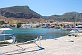 View of the port across the causeway
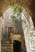 Old house
 Western entrance to the town
 The church of Agios Nikolaos
 Watchtower on the walls
 Bell tower
 A view of the plateau from the west
 The streets of Monemvasia
.jpg)


.jpg)


