
Community hub
Sumba
View on WikipediaSumba (Petjo: Soemba-eiland; Indonesian: pulau Sumba), natively also spelt as Humba, Hubba, Suba, or Zuba (in Sumba languages) is an Indonesian island (part of the Lesser Sunda Archipelago group) located in the Eastern Indonesia and administratively part of the East Nusa Tenggara provincial territory. Sumba has an area of 11,243.78 square kilometres (4,341.25 square miles), about the same size as Jamaica or the island of Hawaii. The population was 686,113 at the 2010 Census[3] and 779,049 at the 2020 Census;[4] the official estimate as of mid-2024 was 853,428 (comprising 436,845 males and 416,583 females).[1] To the northwest of Sumba is Sumbawa, to the northeast, across the Sumba Strait (Selat Sumba), is Flores, to the east, across the Savu Sea (including Savu Island), is Timor, and to the south, across part of the Indian Ocean, is Australia.
Key Information


Nomenclature
[edit]
The name "Sumba" is derived from the native Sumbanese word humba or hubba (in various Subanese dialects)
_from_Melolo_village,_Indonesia,_Honolulu_Museum_of_Art_accession_12983.1.JPG)
History
[edit]Oral traditions
[edit]According to Sumbanese mythology, Flores and Sumba were once connected by the Kataka Lindiwatu (in Sumba languages), an ancient stone bridge built by the native of Sumba and Flores.[5] Due to the high level of socialization around the Kataka Lindiwatu which connected both islands, civilization was thought to arise from around those regions (which nowadays correspond to northern Sumba and to part of East Sumba regency territory). This story belongs to the Sumba oral traditions as was written down by Umbu Pura Woha (2007) in his book Sejarah, Musyawarah dan Adat Istiadat Sumba Timur (lit. 'History, Deliberation and Customs of East Sumba').[5]
Ancient civilization ruins
[edit]
The ruins of the historical civilization of the Sumba people dates back to the BC era; megalithic burials were found on the central regions of the island (Central Sumba) which go back to thousands of years ago. These stone-based burial traditions are still kept alive by the Sumba people and have become a 'living ancient tradition' that still can be observed by scholars in modern days.[6] The megalithic remains found on Sumba Island include dolmen tombs, upright stones, megalithic statues, stone enclosures, and levelled terraces. The Sumba megalithic tradition itself was characterized by the old megaliths built and carved with high quality standards.[7] Some ancient tools are also found on the island. Notable findings are quadrangular adzes unearthed in the Anakalang area (a cultural region of Anakalang Sumba, a subethnic group of Sumba people).[8]
One significant archaeological discovery was that of the urn burial site in Melolo[9] in the 1920s,[10] dated around 2,870 BCE.[11]
Javanese power
[edit]Around the 12th century, the kingdom of Singhasari in eastern Java gained more power over the maritime Southeast Asian territory after the kingdom defeated the Mongols; since then, this kingdom evolved into the empire known as Majapahit. Sumba Island was a subject of Majapahit's dominion, and the word "Sumba" itself was first officially used during the Majapahit era (mentioned in the ancient Javanese manuscripts of Pararaton and Sumpah Palapa oath of Gajah Mada); the word itself was thought as the closest substitution in Javanese for the native name of the island according to native Sumba people, which is Humba or Hubba. It is thought that Javanese people arrived on Sumba Island via the Madura and Kangean route, based on analysis of the DNA of chicken species on Sumba that are only endemic in the eastern parts of Java and its neighbouring islands (which in this case is probably Kangean Island).[12]
European colonizations
[edit]In 1522, the native Sumba came into contact with the Europeans (Portuguese) who arrived on the island by ship to exploit the natural resources of the island. Later, it also attracted the Dutch VOC to come in the region in circa 1600s era. Historically, sandalwood was the main commodity exported to Europe from this island, thus the Sumba Island back then colloquially also known as the Sandalwood Island[13] or Sandel Island (in English).
_in_Watuhadang_TMnr_20018328.jpg)
In 1866, the island of Sumba was transferred to and dominated by the Dutch East Indies colonization power. The well-known Christianization of the natives of Sumba Island was started in 1886 by the Dutch under the Douwe Wielenga Jesuits missionary program in the district of Laura in West Sumba.[14]
Geography, climate and ecology
[edit]
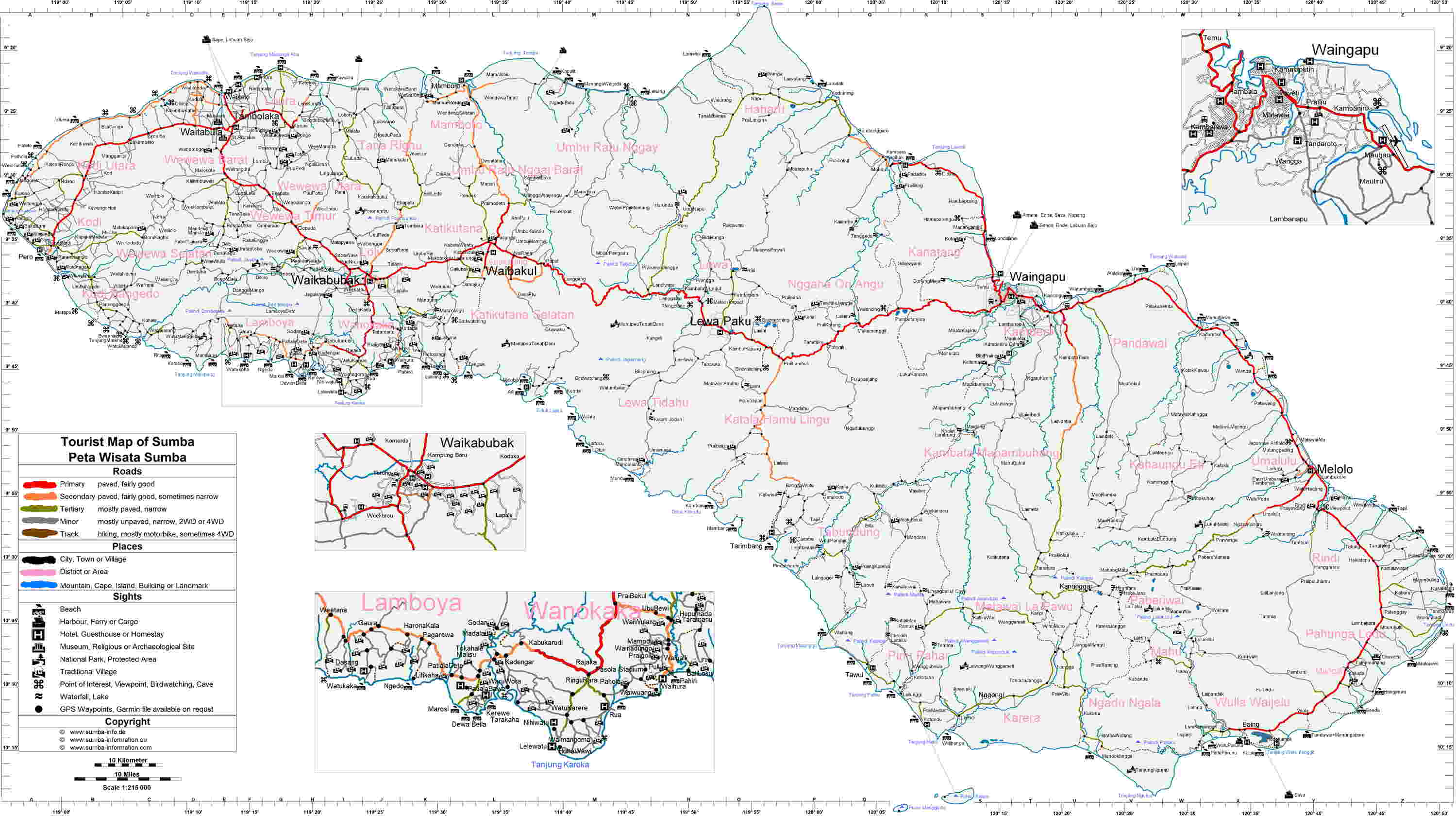
The largest town on the island is the main port of Waingapu near the mouth of the Kambaniru River, with a population of 71,752[2] (including the adjoining district of Kambera) in mid 2023.
The landscape is low, with limestone hills rather than the steep volcanoes of many Indonesian islands. There is a dry season from May to November and a rainy season from December to April. The western side of the island is more fertile and more densely populated than the east.
Although generally thought to be originally part of the Gondwana southern hemisphere supercontinent, recent research suggests that the island might have detached from the South East Asia margin. Most of it was originally covered in deciduous monsoon forest while the south-facing slopes, which remain moist during the dry season, were evergreen rainforest.[15] The northern part of the island is extremely arid; the soils have been depleted by deforestation and erosion.[16]
Sumba is in the Wallacea region, having a mixture of plants and animals of Asian and Australasian origin. Due to its distinctive flora and fauna, Sumba has been categorised by the World Wildlife Fund as the Sumba deciduous forests ecoregion.[15]
Fauna
[edit]
There are a number of mammals, but the island is particularly rich in bird-life with nearly 200 birds, of which seven endemic species and a number of others are found only here and on some nearby islands. The endemic birds include the endangered Sumba eclectus parrot, four vulnerable species — the secretive Sumba boobook owl, Sumba buttonquail, red-naped fruit-dove, and Sumba hornbill — as well as three more common species: the Sumba green pigeon, Sumba flycatcher, and apricot-breasted sunbird.[15] Saltwater crocodiles can still be found in some areas.
The Sumba hornbill or Julang Sumba (Rhyticeros everetti) is under increasing threat of extinction. Indiscriminate deforestation is threatening their survival. The population is estimated at less than 4,000 with an average density of six individuals per square kilometre. A hornbill can fly to and from over an area of up to 100 square kilometres.[17]
Threats and preservation
[edit]Most of the original forest has been cleared for the planting of maize, cassava, and other crops and only small isolated patches of forest remain. Forest clearance is still ongoing due to the growing population of the island and this represents a threat to the birds.[18]
In 1998 two national parks were designated on the island for the protection of endangered species: the Laiwangi Wanggameti National Park and Manupeu Tanah Daru National Park.
Administration
[edit]Sumba is part of the East Nusa Tenggara Province, and there is no single administrative body at the island level. The island and the very small offshore islands administered with it are split into four regencies (local government regions), following re-organisation on 2 January 2007 when two new regencies were created from parts of West Sumba Regency. The four regencies are Sumba Barat (West Sumba), Sumba Barat Daya (Southwest Sumba), Sumba Tengah (Central Sumba) and Sumba Timur (East Sumba), which together accounted for 14.7% of the provincial population in 2023. The regencies are listed below with their areas and their populations at the 2010 Census[3] and the 2020 Census,[4] together with the official estimates as at mid 2024.[2] The provincial capital is not on Sumba Island, but in Kupang on West Timor.
| Kode Wilayah |
Name of City or Regency |
Statute (including year when established) |
Area in km2 |
Pop'n 2010 Census |
Pop'n 2020 Census |
Pop'n mid 2024 Estimate |
Capital | HDI[19] 2022 estimate |
|---|---|---|---|---|---|---|---|---|
| 53.11 | East Sumba Regency (Sumba Timur) |
UU 69/1958 | 7,000.50 | 227,732 | 244,820 | 277,290 | Waingapu | 0.6617 (Medium) |
| 53.12 | West Sumba Regency (Sumba Barat) |
UU 69/1958 | 737.42 | 110,993 | 145,097 | 155,013 | Waikabubak | 0.6443 (Medium) |
| 53.17 | Central Sumba Regency (Sumba Tengah) |
UU 3/2007 | 2,060.54 | 62,485 | 85,482 | 92,354 | Waibakul | 0.6271 (Medium) |
| 53.18 | Southwest Sumba Regency (Sumba Barat Daya) |
UU 16/2007 | 1,445.32 | 284,903 | 303,650 | 328,771 | Tambolaka | 0.6315 (Medium) |
| Sumba | 11,243.78 | 686,113 | 779,049 | 853,428 |
Culture
[edit]

- Protestantism (62.9%)
- Roman Catholic (29.8%)
- Islam (4.05%)
- Marapu and others (3.15%)
- Hinduism (0.10%)
- Buddhism (0.00%)
The west part of Sumba is inhabited by segmentary societies made of clans and of politically autonomous villages, while Sumba North and East are occupied by stratified societies[21] (based on castes[22]) made of clan confederations and led by a dominant clan from which a “king” (raja) is chosen, who yields a real political power.[21] Thus West Sumba is more ethnically and linguistically diverse.[23] Both systems exist simultaneously with a 3-tier class system (aristocracy, common people and slaves) assimilated in such a way that - paradoxically - it does not impair the egalitarian functioning of the Western segmentary societies.[21]
Villages almost always include members of several clans, because at each generation many of the youngest ones settle in villages other than the one they originated from - which may belong to an allied clan and not their own original clan and lineage.[24]
As of 2021, Sumba is the last place on Earth where societies have remained close to the traditions of South-East Asian hill tribes and still build megalithic monuments such as dolmens for collective burials:[25] 100 new megalithic tombs are still built each year on the island. But this too is reflected in the East / West divide: the Western segmentary societies build many more dolmens than the Eastern stratified societies; and dolmens in the east are larger, more richly ornated and are reserved for the royal clan.[26] Waingapu, a Kodi[a] village in the west of Sumba, has some 1,400 dolmens - one of the highest concentrations on the island.[26]
The Sumbanese have a mixture of Austronesian and Melanesian ancestry.[citation needed] Sumba is home to 24 ethnic groups who speak nine Austronesian languages, some of these including several dialects.[27] The largest language group is the Kambera language, spoken by a quarter of a million people in the eastern half of Sumba.[citation needed]
Twenty-five to thirty percent of the population practices the animist Marapu religion. The remainder are Christian, a majority being Dutch Calvinist with a substantial minority being Roman Catholic. A small number of Sunni Muslims can be found along the coastal areas.[citation needed] The younger generations seem to reject Marapu. This may be at least in part because the only functioning schools are Catholic and embracing that religion is required to attend school. Whatever the cause, the difference is significant compared to some other traditional places such as Waerebo, where the locals have a Christian first name and a traditional second name.[28]
Sumba is famous for ikat textiles, particularly very detailed hand-woven ikat. The process of dyeing and weaving ikat is labor-intensive and one piece can take months to prepare.[29] Ikat from West Sumba is notably different to that produced in the East: its only designs are geometric motifs and it usually includes a part that imitates a reticulated python skin.[30]
Development and living standards
[edit]Sumba is one of the poorer islands of Indonesia.[citation needed]
Health
[edit]A relatively high percentage of the population suffers from malaria, although the illness is almost eradicated in the western part of the island. Infant mortality is high.
Water
[edit]Access to water is one of the major challenges on Sumba. During the dry season, many streams dry out and villagers depend on wells for scarce supplies of water.[31] Villagers have to travel several kilometres several times a day to fetch water. It is mainly the women and children who are sent for water, while the men are at work. The Sumba Foundation has been active in raising sponsorship to drill wells in villages and attempting to reduce poverty on the island. As of February 2013, the Sumba Foundation was responsible for 48 wells and 191 water stations, supplying 15 schools with water and sanitation, and reducing malaria rates by some 85%.[32]
Electricity
[edit]Electricity mainly comes from diesel generators.[33] New projects include 3 MW Bayu wind power plant (PLTB) in Kadumbul, East Sumba by PT Hywind. Another is the Bodo Hula Biomass Power Plant (PLTBm), West Sumba. 1 MW capacity. Other existing renewable electricity projects involve solar PV and micro-hydropower.[34]
Tourism
[edit]
Areas of interest
[edit]- Tanggedu Waterfall (Air Terjun Tanggedu), 50 kilometres north-west of Waingapu, the capital city of the East Sumba Regency (the itinerary to the waterfall goes through Purukambera on the coast).[35]
- Puru Kambera Beach, 30 kilometres north-west of Waingapu (one-hour drive)
- Tarimbang Bay, 87 kilometres south-west of Waingapu[36] (three-hour drive), is a surfers paradise with 2- to 3-meter tall waves between June and September.
- Watu Mandorak Cove, a white sandy beach with cliffs 42 kilometers south-west of Tambolaka (two-hour drive in the dry season ; in the rainy season, the journey takes longer and is not recommended).[37]
- Walakiri Beach, 24 km east of Waingapu, for its famed "dancing trees".[38]
- The Sumba Hospitality Foundation is located in West Sumba (Sumba Barat). This organization is dedicated to providing vocational education in hospitality to underprivileged students hailing from all across Sumba.[39]
Resorts
[edit]NIHI Sumba has been ranked as one of the world's five best eco-hotels and was awarded the world's best hotel of 2016 and 2017 from Travel + Leisure for its native ambiance and authentic local experience.[40]
See also
[edit]Notes
[edit]References
[edit]- ^ a b Badan Pusat Statistik, Jakarta, 28 February 2025, Provinsi Nusa Tenggara Timur Dalam Angka 2025 (Katalog-BPS 1102001.53)
- ^ a b c Badan Pusat Statistik, Jakarta, 28 February 2024, Provinsi Nusa Tenggara Timur Dalam Angka 2024 (Katalog-BPS 1102001.53)
- ^ a b Biro Pusat Statistik, Jakarta, 2011.
- ^ a b Badan Pusat Statistik, Jakarta, 2021.
- ^ a b "Kampung Wunga, Tanah Kelahiran Masyarakat Sumba" [Wunga Settlement, The Birthplace of Sumba Community] (in Indonesian). 2014.
- ^ Richter, Anne; Carpenter, Bruce W.; Carpenter, Bruce; Sundermann, Jorg (16 May 2012). Gold Jewellery of the Indonesian Archipelago. Editions Didier Millet. p. 119. ISBN 978-981-4260-38-1. Retrieved 2 February 2013.
- ^ "Kampung Tarung Sumba" [Tarung Settlement of Sumba] (in Indonesian). 2018.
- ^ Simanjuntak, Truman (2006). Archaeology: Indonesian Perspective : R.P. Soejono's Festschrift. Yayasan Obor Indonesia. p. 288. ISBN 978-979-26-2499-1. Retrieved 2 February 2013.
- ^ "Melolo, map". google.com/maps.
- ^ Handini, Retno; Noerwidi, Sofwan; Sofian, Harry Octavianus; Fauzi, Ruly; Prasetyo, Unggul; Geria, I Made; Ririmasse, Marlon; Nasution, Devi Ayu Aurora; Rahayuni, Restu Ambar; Simanjuntak, Truman (July–August 2023). "New evidence on the early human occupation in Sumba Islands" [Nouvelles preuves de l’occupation humaine précoce dans les îles de Sumba]. L'Anthropologie. 127 (3). doi:10.1016/j.anthro.2023.103152. Retrieved 2024-06-15.
- ^ Koesbardiati, Toetik; Murti, Delta Bayu; Herina, Dessytri Ayu; Sari, Ayu Ambar (2018). "The occurrence of enamel hypoplasia, porotic hyperostosis and cribra orbitalia in three prehistoric skeletal assemblages from Indonesia". Bull Int Assoc Paleodont. 12 (2): 33–40. Retrieved 2024-06-15.
- ^ "Antara Majapahit, Sumba, dan Ayam Jantan Merah" [(Connecting the Dots) Between Majapahit, Sumba, and the Red Rooster]. Indonesian Institute of Sciences (in Indonesian). 2016.
- ^ Goodall, George (editor) (1943) Philips' International Atlas, London, George Philip and Son map 'East Indies' pp.91-92
- ^ Barker, Joshua (1 July 2009). State of Authority: The State in Society in Indonesia. SEAP Publications. p. 123. ISBN 978-0-87727-780-4. Retrieved 2 February 2013.
- ^ a b c Wikramanayake, Eric D. (2002). Terrestrial Ecoregions of the Indo-Pacific: A Conservation Assessment. Island Press. p. 532. ISBN 978-1-55963-923-1. Retrieved 2 February 2013.
- ^ "Sumba". sumba-information.eu (in French). Retrieved 2024-06-15.
- ^ "Sumba Hornbills under increasing threat of extinction". Antara News. 18 June 2011. Retrieved 2 February 2013.
- ^ "Sumba deciduous forests". Terrestrial Ecoregions. World Wildlife Fund.
- ^ "[New Method] Human Development Index by Regency/City 2020-2022" (in Indonesian). Statistics Indonesia. 2022. Retrieved 13 February 2023.
- ^ "Religion in Indonesia".
- ^ a b c Jeunesse, Christian; Bec-Drelon, Noisette; Boulestin, Bruno; Denaire, Anthony (2021). "Aspects de la gestion des dolmens et des tombes collectives actuels dans les sociétés de l'île de Sumba (Indonésie)" [Ethnoarchaeology of funeral practices: aspects of the management of current dolmens and collective tombs in the tribal societies of Sumba Island (Indonesia)]. Préhistoires méditerranéennes. 9 (2): 165-179 (see § 6). Retrieved 2024-06-15.
- ^ Forshee, Jill (2006). Culture and Customs of Indonesia. Greenwood Publishing Group. p. 41. ISBN 978-0-313-33339-2. Retrieved 2 February 2013.
- ^ Müller, Kal (1997). East of Bali: From Lombok to Timor. Tuttle Publishing. p. 170. ISBN 978-962-593-178-4. Retrieved 2 February 2013.
- ^ Jeunesse et al. 2021, § 7.
- ^ Jeunesse et al. 2021, § 3.
- ^ a b Jeunesse et al. 2021, § 8.
- ^ a b Jeunesse et al. 2021, § 4.
- ^ "Marapu and other weird things in Sumba". whatsnextnaomi.com. Retrieved 2024-06-15.
- ^ Sertori, Trisha (30 August 2012). "Sumba on show in Bali". The Jakarta Post. Retrieved 2024-06-15.
- ^ "Ikat from West Sumba, Indonesia". ikat.us. Retrieved 2024-06-15.
- ^ Hoepfner, Maren (4 March 2010). "Taking Sumba by surprise". The Jakarta Post. Retrieved 2024-06-15.
- ^ "The Sumba Foundation". sumbafoundation.org. Retrieved 2024-06-15.
- ^ Oswal, R.; Jain, P.; Muljadi, E.; Hirsch, B.; Castermans, B.; Chandra, J.; Raharjo; Hardison, R. (January 2016). "System Impact Study of the Eastern Grid of Sumba Island, Indonesia. Steady-State and Dynamic System Modeling for the Integration of One and Two 850-kW Wind Turbine Generators" (PDF) (Technical Report NREL/TP-5D00-65458). US National Renewable Energy Laboratory (NREL). p. 1.
- ^ "100% Renewable energy Atlas: Sumba Island, Indonesia". 100-percent.org. 21 January 2019. Retrieved 21 April 2020.
- ^ Annabel Symonds (9 March 2017). "7 Tips For Visiting Tanggedu Waterfall In Sumba Indonesia". londonerinsydney.com. Retrieved 2024-06-15.
- ^ "Tarimbang to Waingapu, itinerary". google.com/maps.
- ^ "Sumba". komodotouristic.com. Retrieved 2024-06-15.
- ^ ""Dancing trees" of Walakiri Beach, photo". vikaschander.com. 21 October 2022. Retrieved 2024-06-23.
- ^ "Sumba Hospitality Foundation". sumbahospitalityfoundation.org. Retrieved 2024-06-15.
- ^ Intan Tanjung (July 12, 2016). "Indonesia home to 'world's best hotel' of 2016". thejakartapost.com. Retrieved 2024-06-15.
Bibliography
[edit]- Paccou-Martellière, Véronique; Hinterseer, Thomas H. (2016). Arts and traditions of Sumba. Paris: Le Livre D Art. ISBN 978-2-355-32241-9.
External links
[edit]- Sumba tourist and social information (private website)
- . Encyclopædia Britannica (11th ed.). 1911.
Maps
[edit]- "Tourist and Road Map of Sumba". files.creatr.de. Retrieved 2024-06-15.
- "High-resolution map of West Sumba with contour lines". maps.lib.utexas.edu (made by the US Army Map service). Retrieved 2024-06-15.
| International | |
|---|---|
| National | |
| Other | |
Sumba
View on GrokipediaEtymology
Nomenclature and Linguistic Origins
The name Sumba derives from the indigenous term humba or hubba, meaning "original," "native," or "real" in local Sumba languages, reflecting the island's identity as the homeland of its first inhabitants.[8][9] This designation appears consistently across Sumbanese dialects, often extended as Wai Humba, where wai denotes land or water, underscoring a foundational connection to the territory.[10] The languages spoken on Sumba belong to the Austronesian phylum, particularly the Central Malayo-Polynesian subgroup within the Malayo-Polynesian branch, tracing their origins to Neolithic farming migrations from mainland Asia via the Philippines and Sulawesi around 3,500 years ago.[11] These Austronesian tongues arrived in a linguistic contact zone, overlaying potential pre-existing substrates from earlier Papuan or Australo-Melanesian populations, though direct evidence for such substrates remains limited and debated in genetic-linguistic correlations.[11][12] Sumba hosts at least seven to eleven distinct indigenous languages, varying by dialect continuum and mutual intelligibility, including well-documented ones like Kambera (eastern Sumba's lingua franca with over 200,000 speakers) and others such as Mamboru, Anakalang, and Kodi.[13][14] Linguistic documentation commenced in the 19th century under Dutch colonial administration, with Kambera receiving the earliest systematic grammars and dictionaries, though many western varieties remain underdescribed due to isolation and oral traditions.[15] Indonesian serves as the national overlay, but native languages retain core retention of Austronesian lexicon tied to local ecology and social structures, correlating positively with genetic markers of ancestral continuity.[12]Geography
Physical Features and Terrain
Sumba Island exhibits a low-relief, non-volcanic terrain dominated by raised coral limestone plateaus, rolling hills, and savanna-like landscapes, distinguishing it from the volcanic islands prevalent in Indonesia. Covering approximately 11,000 square kilometers, the island's highest elevation reaches 1,225 meters at Mount Wanggameti, located within the Laiwangi Wanggameti National Park in the central region. [3][16] The geology primarily consists of coral limestone formations, with minor volcanic rocks confined to the southern coast, fostering karst features including caves, sinkholes, and dissected plateaus broken by valleys and irregular hills. [17][18] The interior terrain features undulating hills and broad savanna plateaus, often covered in grasslands that transition into drier landscapes during the extended dry season. Tectonic activity has shaped coastal landforms, notably producing emerged coral reef terraces along the northern coast through uplift, creating stepped topography visible in reef sequences. [19][20] These features contribute to limited flat coastal plains, with most rivers being short, seasonal streams that drain the hilly interior into the Indian Ocean to the south and the Savu Sea to the north. The karstic nature of the limestone bedrock results in porous soils and subterranean drainage in places, influencing surface hydrology and landforms. [21]Climate Patterns
Sumba's climate is tropical savanna, marked by consistently warm temperatures and a bimodal precipitation pattern driven by monsoon winds. Average daily high temperatures range from 28°C in January to 30°C in September and October, with lows between 26°C and 27°C throughout the year, resulting in minimal thermal variation due to the island's equatorial proximity.[22] Relative humidity exceeds 80% annually, often creating muggy conditions, while average wind speeds peak at 16 km/h in August during the dry season.[22] The wet season spans November to April, coinciding with the northwest monsoon that brings moist air from the Asia-Australia convergence zone, delivering peak rainfall of 284 mm in January and similar amounts in February.[22] Cloud cover reaches 91% during this period, enhancing convective showers. The dry season, from May to October, features southeast trade winds that suppress rainfall, with August averaging just 33 mm and fewer than five rainy days per month.[22] Annual totals average 1,400–1,600 mm island-wide, though regional disparities exist: the northern coast receives under 1,000 mm due to rain shadow effects from central highlands, while southern and interior zones exceed 1,500 mm from orographic lift.[23] These patterns are modulated by the El Niño-Southern Oscillation, with El Niño events intensifying dry conditions in southern Indonesia, including Sumba, by weakening monsoon flows and extending drought risks into the early wet season.[24] Historical data indicate stable long-term averages but increasing variability in rainfall onset and intensity, linked to broader Indo-Pacific dynamics.[23]Ecological Zones
Sumba's ecological zones are primarily characterized by the Sumba deciduous forests ecoregion, encompassing semi-evergreen monsoon forests adapted to the island's semi-arid, seasonal climate with distinct wet and dry periods.[25] The dominant natural vegetation consists of deciduous monsoon forests, where many tree species shed leaves during the prolonged dry season to conserve water, interspersed with savanna grasslands that have expanded due to historical deforestation and agricultural expansion. Remnant forest patches persist in protected gullies, steeper slopes, and higher elevations, supporting higher biodiversity, while open grasslands dominate flatter, lowland areas and exhibit a barren appearance in the dry season.[25][26] In the northern regions, monsoon deciduous forests prevail, featuring drought-tolerant species such as Terminalia and Albizia trees, reflecting the area's exposure to drier conditions and Asian-Australian floral influences.[3] Southern coastal hill slopes, benefiting from orographic rainfall, retain pockets of lowland evergreen rain forests with denser canopies and species like dipterocarps, though these have been fragmented by human activity.[25] These forests harbor endemic fauna, including the Sumba hornbill (Rhyticeros everetti) and various buttonquails, which depend on closed-canopy habitats for nesting and foraging.[27] Coastal zones feature mangroves and salt-tolerant scrub vegetation, particularly along northern shores where they occupy diverse substrates including mudflats, sandy beaches, and rocky outcrops, serving as critical buffers against erosion and nurseries for marine species.[28] Adjacent marine habitats include fringing coral reefs in the surrounding waters, part of the Coral Triangle, supporting reef-associated biodiversity amid threats from overfishing and sedimentation.[29] Overall, the island's uplifted coral reef geology and monsoonal hydrology create heterogeneous freshwater ecosystems, such as seasonal streams and wetlands, embedded within terrestrial zones and influencing local endemism.[30]History
Prehistoric Settlements and Megalithic Sites
Archaeological investigations have revealed evidence of human occupation on Sumba dating back at least 2,800 years, with sites including Lambanapu, Melolo, Kambaniru, Mborobakung, and Wunga providing artifacts indicative of Austronesian-speaking communities possessing complex cultural practices.[31][32] These findings, reported by Indonesia's National Research and Innovation Agency (BRIN) and corroborated in peer-reviewed studies, suggest settlement around 1,000 BCE, aligning with broader Austronesian expansions in the region.[31] Prehistoric burial practices on the island include urn fields discovered at Melolo in East Sumba, which date to the early Metal Age, approximately 500 BCE to 500 CE, containing human remains and associated grave goods.[33] These sites represent some of the earliest documented funerary traditions, predating the more elaborate megalithic structures while foreshadowing the island's enduring focus on monumental stone memorials.[34] Sumba's megalithic sites, featuring large stone tombs, menhirs, and dolmens, trace their origins to this prehistoric era, with construction techniques involving the quarrying of local and distant stone slabs, sometimes carved directly from bedrock.[35][36] Notable concentrations occur in areas like Anakalang in West Sumba, where clusters of megalithic tombs of substantial proportions served residential and commemorative functions linked to ancestral veneration.[37] While many such monuments were erected in later periods, their prehistoric foundations underscore a continuity in Sumba's stone-working traditions, sustained without significant technological interruption into modern times.[38]Oral Traditions and Early Clan Formations
Sumba's oral traditions, preserved without a written script, encompass multiple genres that transmit clan histories, mythological origins, and ancestral lineages, with Li Ndai or Li Marapu specifically recounting the tales of clan founders and marapu (deified ancestors) whose influence is believed to affect the living.[39] These narratives, recited in ritual contexts by elders or priests (rato), reinforce social norms, identity, and clan obligations, often integrating invocations to ancestors for prosperity or guidance.[39] Mythological accounts describe the island's earliest inhabitants as originating from heavenly realms, with traditions varying by region but commonly invoking eight ancestral pairs or priest-deities descending from a celestial "Community of Eight Levels" (awangu walu ndani).[40] [41] One prevalent legend posits the first humans emerging from unions between children of celestial bodies—the moon and sun—forming eight couples who populated the land, establishing Tana Humba (island of the divine house) through rituals linking sky and earth via mythical staircases.[40] Clan founders, often deified as marapu, are depicted as migrating from these divine sources, with myths like that of Umbu Padjodjang illustrating early schisms: a priest-deity breaking from a ruling lineage to form a new patrilineal group (kabihu), legitimizing autonomy and ritual authority.[42] Early clan formations structured society into patrilineal kabihu, each tracing descent from a singular mythical ancestor, forming segmentary units with autonomous villages and specialized roles such as royal priests, warriors, or kin groups supporting central temples.[41] These clans, numbering around 16 in districts like Kapunduk, integrated into hierarchical strata: royalty (maramba or raja), free householders (kabihu members), and bound servants (ata), with high bride-prices regulating alliances and status mobility.[41] [40] Oral myths, categorized by setting—sacred temple-house recitals of divine treks, porch-side elder tales of exploits, or garden harvest lore—served to encode these origins, enforcing cohesion amid inter-clan competitions like ritual warfare for fertility.[41] The marapu cult, central to these traditions, venerated clan ancestors as intermediaries, with about 65% of eastern Sumbanese adhering to such beliefs into modern times.[39]External Influences and Javanese Era
Sumba's exposure to external influences began through maritime trade networks, particularly in sandalwood and horses, which connected the island to broader Southeast Asian markets as early as the medieval period. These exchanges introduced goods such as metals, ceramics, and textiles from regional powers, fostering limited economic integration without significant disruption to indigenous social structures.[43][18] The Javanese era, centered on the Majapahit Empire (1293–1527), marked a period of nominal suzerainty over Sumba, as documented in the 1365 Old Javanese epic Nagarakṛtāgama, which lists "Tana Sumba" among the empire's distant dependencies. This reference reflects Majapahit's expansive claims during its peak under Hayam Wuruk (r. 1350–1389), extending influence through tribute systems and trade routes rather than direct governance over remote islands like Sumba. Archaeological and cultural evidence indicates minimal Javanese administrative or religious imposition, with Sumba's megalithic traditions and Marapu beliefs remaining dominant.[43][18][33] Following Majapahit's decline in the early 15th century, Javanese influence waned, giving way to interactions with eastern Indonesian polities such as Bima in Sumbawa, though trade continuities persisted. The era's legacy appears confined to episodic commercial ties, with no verifiable records of Javanese settlements or lasting institutional changes on the island.[18][44]Colonial Period and European Interventions
European contact with Sumba began in the early 16th century, with Portuguese explorers arriving in 1522 to exploit natural resources, though this resulted in limited sustained influence.[45] Dutch interest emerged in the mid-18th century through the VOC, which in 1750 secured an oral contract with northern coastal rulers for exclusive trade rights.[46] Formal incorporation into the Dutch East Indies occurred in 1866, when the island was ceded to Dutch control, and the first controleur, Samuel Roos, was installed in August at Kambaniru to oversee administration.[47][48] Initial Dutch governance was indirect and faced resistance due to ongoing inter-clan warfare, headhunting, enslavement, and human sacrifice, which disrupted trade and prompted interventions.[48] In 1879, the island was divided into East and West onderafdelingen to strengthen presence, with the controleur office relocated to Waingapu in 1875.[47] Military pacification escalated in 1901 during the Lambanapu War, where Dutch forces intervened against local rajas, followed by a 1906 campaign led by Lieutenant Rijnders to suppress clan conflicts.[47] By 1908, pacification was largely achieved, prohibiting warfare, the slave trade, and headhunting, though enforcement was gradual and rebellions persisted in 1909, 1911, and 1925–1926.[47][49] Administrative consolidation advanced in 1912–1913, when Sumba was organized as a single afdeeling comprising four onderafdelingen—East, Central, Northwest, and Southwest—marking full integration into the colonial system.[47][48] European missionary activities complemented secular control; Catholic efforts operated in western Sumba from 1886 to 1898, yielding limited converts, before Dutch Calvinist missions expanded Protestant influence from the early 20th century, establishing schools and churches.[44] Colonial policies introduced infrastructure like roads and basic education while maintaining indirect rule through local rajas, preserving aspects of traditional hierarchy amid suppression of violent customs.[47] Dutch oversight ended with Japanese occupation in 1942, though pre-war interventions had curtailed endemic conflicts and integrated Sumba into broader East Indies governance.[47]Independence and Modern Integration
Sumba experienced a delayed transition to Indonesian sovereignty compared to more central regions. The proclamation of independence by Sukarno on August 17, 1945, reached the island only after six months, reflecting its remoteness and limited communication infrastructure. Unlike Java and Sumatra, where local populations actively participated in the national revolution against returning Dutch forces, Sumba saw no significant armed resistance or community involvement in the independence struggle, allowing Dutch administration to persist longer in Nusa Tenggara Timur (NTT).[8][50] Full incorporation into the Republic of Indonesia occurred on August 17, 1950, when federal states in eastern Indonesia, including Sumba, dissolved into the unitary state, marking the formal handover from Dutch control. This aligned with the broader restructuring of the United States of Indonesia into a centralized republic on its fifth independence anniversary. Sumba was integrated into the newly formed NTT province, with traditional rulers—such as the Dutch-appointed rajas—initially retaining influence, though the Dewan Raja (Council of Kings) was disbanded as national authority centralized. By 1958, under Sukarno's guidance, a more democratic local governance system was introduced, shifting power from hereditary elites to elected councils while preserving clan-based social structures.[8][50][51][18] In the post-independence era, Sumba's administrative divisions evolved to facilitate integration: the island was split into East Sumba and West Sumba regencies in the mid-1950s, with further subdivisions in West Sumba in 2007 to address local governance needs. The New Order regime under Suharto (1966–1998) emphasized national development programs, including infrastructure and agriculture, but Sumba remained economically marginal, with slow modernization preserving megalithic traditions and Marapu beliefs amid Christian missionary influences. Post-1998 reforms brought decentralization, enabling local elites to appropriate modern institutions like elections and NGOs, though ethnic violence erupted in the late 1990s, underscoring tensions between traditional hierarchies and state authority. Contemporary integration focuses on sustainable development, such as renewable energy initiatives since 2010, yet persistent poverty and cultural isolation highlight incomplete assimilation into Indonesia's national framework.[44][52][53]Administration and Governance
Administrative Divisions
Sumba, as part of East Nusa Tenggara Province, is divided into four regencies (kabupaten), each governing distinct portions of the island's territory. These divisions were established through successive splits from the original East and West Sumba regencies created on 13 December 1958. West Sumba Regency was further divided to form Southwest Sumba Regency on 2 January 2007 and Central Sumba Regency on 22 May 2007, reflecting Indonesia's decentralization efforts to improve local administration and development.[50][3] The regencies are:- East Sumba Regency (Kabupaten Sumba Timur): Capital at Waingapu, covering an area of 7,000.5 km² with a population of approximately 250,788 as of 2021. Wait, but no wiki. From [web:32] luas 7,000.50 km², pop from [web:29] but wiki, alternative [web:30] same.
| Regency | Capital | Area (km²) | Population (approx., recent) |
|---|---|---|---|
| East Sumba | Waingapu | 7,000.5 | 251,000 (2020) |
| Regency | Indonesian Name | Capital |
|---|---|---|
| East Sumba | Sumba Timur | Waingapu |
| West Sumba | Sumba Barat | Waikabubak |
| Central Sumba | Sumba Tengah | Waibakul |
| Southwest Sumba | Sumba Barat Daya | Tambolaka |
Local Politics and Corruption Issues
Local governance in Sumba operates under Indonesia's decentralization framework, with regencies such as West Sumba, East Sumba, Central Sumba, and Southwest Sumba holding direct elections for bupati (regents) and vice-regents since 2005, blending modern democratic processes with traditional clan-based hierarchies known as uma politics.[61] These elections often reflect entrenched rivalries among clans and domains (kabihu), where candidates leverage ancestral authority and social networks to mobilize voters, sometimes exacerbating socio-economic inequalities despite national democratization efforts.[62] In the 2020 East Sumba regency election, identity politics surfaced through implicit appeals to kabihu affiliations, influencing voter preferences without overt ethnic mobilization.[63] Electoral disputes highlight tensions between formal institutions and informal power structures. The 2024 West Sumba regent election faced a results dispute petition, dismissed by Indonesia's Constitutional Court on February 5, 2025, due to filing past the deadline.[64] In Southwest Sumba's concurrent election, candidate pair Ratu Ngadu Bonnu Wulla-Dominikus Alphawan Rangga Kaka refuted allegations of mobilizing civil servants for campaigning, as testified in court proceedings.[65] Broader concerns include practices like stone-dragging rituals in Central Sumba, interpreted by observers as symbolic assertions of traditional authority that could undermine democratic accountability.[66] Corruption scandals have plagued local administration, particularly in public procurement and election funding. In East Sumba, prosecutors raided the local Election Commission (KPU) office on September 29, 2025, investigating alleged misuse of Rp 27.7 billion in hibah (grant) funds allocated for the 2024 regional elections, with suspicions of embezzlement by officials.[67] Former East Sumba Regent Krishtofel Praing was questioned for eight hours on October 20, 2025, regarding the diversion of these funds, followed by examinations of the regency secretary and DPRD members like Ali Oemar Fadaq.[68][69] Legal practitioners have emphasized the roles of internal auditors (APIP), the Audit Board of Indonesia (BPK), and the DPRD in oversight failures that enabled the scandal.[70] In West Sumba, a separate probe targets land acquisition corruption in the Rp 9 billion Ring Road project, resulting in an estimated Rp 8 billion state loss, as audited by BPK and pursued by the local prosecutor's office.[71] Earlier, in 2023, the West Sumba prosecutor's office completed files on a corruption case involving a deputy regency chairman related to asset sales.[72] These incidents underscore systemic vulnerabilities in regency-level fund management, where weak internal controls and patronage networks facilitate graft, despite commitments from prosecutors to eradicate corruption.[73] A 2017 whistleblower case in East Nusa Tenggara, involving Daud Ndakularak reporting graft, illustrates ongoing risks to informants in such environments.[74]Demographics
Population Statistics and Ethnic Groups
The population of Sumba Island, divided among four regencies, totaled approximately 895,000 in 2023, reflecting modest annual growth from the 2020 census figure of around 779,000 driven by natural increase in rural areas.[75][76][77][78] Population density remains low at about 70 persons per square kilometer, concentrated in coastal and riverine settlements, with over 80% residing in rural villages characterized by extended family compounds.[79]| Regency | 2023 Population Estimate |
|---|---|
| West Sumba | 141,780 |
| East Sumba | 262,880 |
| Central Sumba | 90,418 |
| Southwest Sumba | 400,221 |
Languages and Cultural Assimilation
Sumba Island features a diverse array of indigenous languages from the Sumba-Hawu subgroup of the Austronesian family, with estimates ranging from seven to eleven distinct languages spoken by the local population.[14][13] Kambera, the most widely spoken, has around 250,000 speakers concentrated in the eastern half of the island and functions as a lingua franca across central and eastern Sumba, encompassing dialects such as Melolo, Uma Ratu Nggai, Lewa, Kanatang, and Mangili-Waijelo.[82] In western Sumba, Wejewa is prominent with approximately 65,000 speakers, while other languages include Anakalang, Kodi, Lamboya, Loli, Momboru, and Wanukaka, each tied to specific ethnic subgroups and regions.[83][84] Indonesian (Bahasa Indonesia), the national language, is used officially in government, education, and inter-ethnic communication, but indigenous languages dominate daily rural interactions.[3] Linguistic vitality among Sumba's indigenous languages remains relatively strong, particularly in rural villages where they are the primary medium of home and community life, with a 2019 baseline study in East Sumba indicating that 72% of children use local languages such as Kambera.[13][85] However, formal education and administrative functions conducted exclusively in Indonesian contribute to gradual shifts, especially among younger urban residents and migrants, raising concerns about potential language erosion without targeted preservation efforts.[13] Documentation of western Sumba languages lags behind Kambera, which has received more scholarly attention since the 19th century, underscoring uneven risks to lesser-studied varieties.[13] Cultural assimilation in Sumba has proceeded unevenly, with indigenous languages and traditions persisting amid national integration policies that emphasize Indonesian as a unifying medium since independence in 1945.[86] Strong clan-based social structures and the Marapu belief system have buffered against wholesale adoption of mainland Indonesian norms, maintaining linguistic endogamy where local languages reinforce ethnic identities like Weyewa versus broader "Indonesian" speech.[86] Modernization drivers, including expanded schooling and technology access as of the early 21st century, accelerate bilingualism but have not supplanted local tongues in core domains, though marginalization of non-Indonesian speakers in formal sectors fosters selective assimilation among elites.[87] This dynamic reflects Indonesia's broader linguistic policy favoring national cohesion over regional diversity, yet Sumba's isolation and cultural conservatism limit deeper convergence compared to more urbanized islands.[88]Culture and Society
Marapu Religion and Ancestor Worship
 following samadhi meditative preparation, incorporate offerings of betel nut, areca, holy water, and livestock to appease animistic forces in nature and the spirit world.[87][89] Notable examples include Pasola, a ritualized horseback combat enacted biennially to symbolize ancestral blessings for soil renewal, and Weri Mara, a three-month coastal taboo period sacralizing marine resources for preservation.[89] These practices, varying by region and clan, persist despite historical colonial derogation as superstitious and contemporary administrative biases favoring monotheistic faiths, prompting syncretic adaptations in many communities.[89][3]