
Community hub
Recent from talks
Contribute something
Nothing was collected or created yet.
Trans-Siberian Railway
View on Wikipedia
| Trans-Siberian Railway | |||||||||||||||||||||||||||||||||||||||||||||||||||||||||||||||||||||||||||||||||||||||||||||||||||||||||||||||||||||||||||||||||||||||||||||||||||||||||||||||||||||||||||||||||||||||||||||||||||||||||||||||||||||||||||||||||||||||||||||||||||||||||||||||||||||||||||||||||||||||||||||||||||||||||||||||||||||||||||||||||||||||||||||||||||||||||||||||||||||||||||||||||||||||||||||||||||||||||||||||||||||||||||||||||||||||||||||||||||||||||||||||||||||||||||||||||||||||||||||||||||||||||||||||||||||||||||||||||||||||||||||||||||||||||||||||||||||||||||||||||||||||||||||||||||||||||||||||||||||||||||||||||||||||||||||||||||||||||||||||||||||||||||||||||||||||||||||||||||||||||||||||||||||||||||||||||||||||||||||||||||||||||||||||||||||||||||||||||||||||||||||||||||||||||||||||||||||||||||||||||||||||||||||||||||||||||||||||||||||||||||||||||||||||||||||||||||||||||||||||||||||||||||||||||||||||||||||||||||||||||||||||||||||||||||||||||||||||||||||||||||||||||||||||||||||||||||||||||||||||
|---|---|---|---|---|---|---|---|---|---|---|---|---|---|---|---|---|---|---|---|---|---|---|---|---|---|---|---|---|---|---|---|---|---|---|---|---|---|---|---|---|---|---|---|---|---|---|---|---|---|---|---|---|---|---|---|---|---|---|---|---|---|---|---|---|---|---|---|---|---|---|---|---|---|---|---|---|---|---|---|---|---|---|---|---|---|---|---|---|---|---|---|---|---|---|---|---|---|---|---|---|---|---|---|---|---|---|---|---|---|---|---|---|---|---|---|---|---|---|---|---|---|---|---|---|---|---|---|---|---|---|---|---|---|---|---|---|---|---|---|---|---|---|---|---|---|---|---|---|---|---|---|---|---|---|---|---|---|---|---|---|---|---|---|---|---|---|---|---|---|---|---|---|---|---|---|---|---|---|---|---|---|---|---|---|---|---|---|---|---|---|---|---|---|---|---|---|---|---|---|---|---|---|---|---|---|---|---|---|---|---|---|---|---|---|---|---|---|---|---|---|---|---|---|---|---|---|---|---|---|---|---|---|---|---|---|---|---|---|---|---|---|---|---|---|---|---|---|---|---|---|---|---|---|---|---|---|---|---|---|---|---|---|---|---|---|---|---|---|---|---|---|---|---|---|---|---|---|---|---|---|---|---|---|---|---|---|---|---|---|---|---|---|---|---|---|---|---|---|---|---|---|---|---|---|---|---|---|---|---|---|---|---|---|---|---|---|---|---|---|---|---|---|---|---|---|---|---|---|---|---|---|---|---|---|---|---|---|---|---|---|---|---|---|---|---|---|---|---|---|---|---|---|---|---|---|---|---|---|---|---|---|---|---|---|---|---|---|---|---|---|---|---|---|---|---|---|---|---|---|---|---|---|---|---|---|---|---|---|---|---|---|---|---|---|---|---|---|---|---|---|---|---|---|---|---|---|---|---|---|---|---|---|---|---|---|---|---|---|---|---|---|---|---|---|---|---|---|---|---|---|---|---|---|---|---|---|---|---|---|---|---|---|---|---|---|---|---|---|---|---|---|---|---|---|---|---|---|---|---|---|---|---|---|---|---|---|---|---|---|---|---|---|---|---|---|---|---|---|---|---|---|---|---|---|---|---|---|---|---|---|---|---|---|---|---|---|---|---|---|---|---|---|---|---|---|---|---|---|---|---|---|---|---|---|---|---|---|---|---|---|---|---|---|---|---|---|---|---|---|---|---|---|---|---|---|---|---|---|---|---|---|---|---|---|---|---|---|---|---|---|---|---|---|---|---|---|---|---|---|---|---|---|---|---|---|---|---|---|---|---|---|---|---|---|---|---|---|---|---|---|---|---|---|---|---|---|---|---|---|---|---|---|---|---|---|---|---|---|---|---|---|---|---|---|---|---|---|---|---|---|---|---|---|---|---|---|---|---|---|---|---|---|---|---|---|---|---|---|---|---|---|---|---|---|---|---|---|---|---|---|---|---|---|---|---|---|---|---|---|---|---|---|---|---|---|---|---|---|---|---|---|---|---|---|---|---|---|---|---|---|---|---|---|---|---|---|---|---|---|---|---|---|---|---|---|---|---|---|---|---|---|---|---|---|---|---|---|---|---|---|---|---|---|---|---|---|---|---|---|---|---|---|---|---|---|---|---|---|---|---|---|---|---|---|---|---|---|---|---|---|---|---|---|---|---|---|---|---|---|---|---|---|---|---|---|---|---|---|---|---|---|---|---|---|---|---|---|---|---|---|---|---|---|---|---|---|---|---|---|---|---|---|---|---|---|---|---|---|---|---|---|---|---|---|---|---|---|---|---|---|---|---|---|---|---|---|---|---|---|---|---|---|---|---|---|---|---|---|---|---|---|---|---|---|---|---|---|---|---|---|---|---|---|---|---|---|---|---|---|---|---|---|---|---|---|---|---|---|---|---|---|---|---|---|---|---|---|---|---|---|---|---|---|---|---|---|---|---|---|---|---|---|---|---|---|---|---|---|---|---|---|---|---|---|---|---|---|---|---|---|---|---|---|---|---|---|---|---|---|---|---|---|---|---|---|---|---|---|---|---|---|---|---|---|---|---|---|---|---|---|---|---|---|---|---|---|---|---|---|---|---|---|---|---|---|---|---|---|---|---|---|---|---|---|---|---|---|---|---|---|---|---|---|---|---|---|---|---|---|---|---|---|---|---|---|---|---|---|---|---|---|---|---|---|---|---|---|---|---|---|---|---|---|---|---|---|---|---|---|---|---|---|---|---|---|---|---|---|---|---|---|---|---|---|---|---|---|---|---|
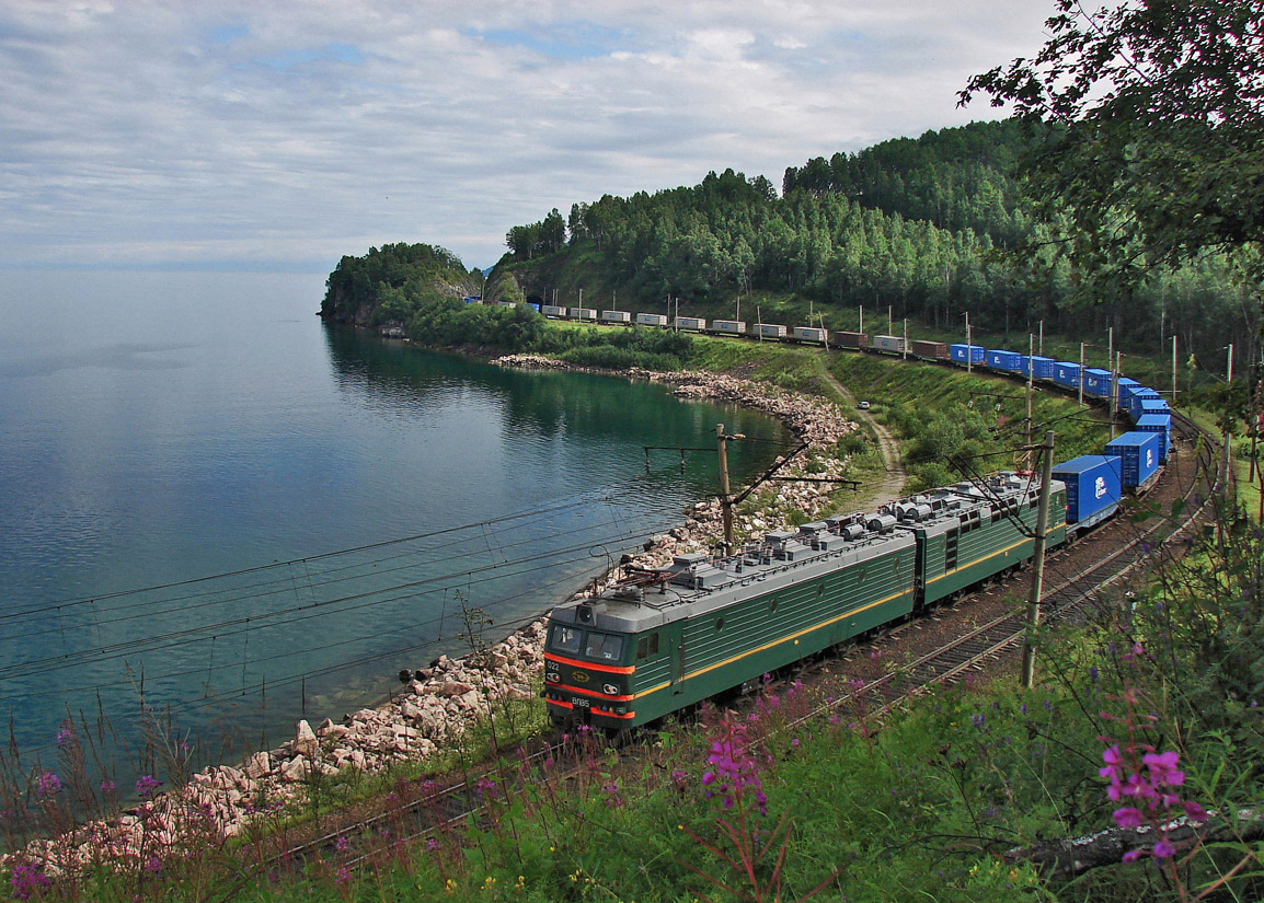
 VL85 container haul along the coast of Lake Baikal (2008) | |||||||||||||||||||||||||||||||||||||||||||||||||||||||||||||||||||||||||||||||||||||||||||||||||||||||||||||||||||||||||||||||||||||||||||||||||||||||||||||||||||||||||||||||||||||||||||||||||||||||||||||||||||||||||||||||||||||||||||||||||||||||||||||||||||||||||||||||||||||||||||||||||||||||||||||||||||||||||||||||||||||||||||||||||||||||||||||||||||||||||||||||||||||||||||||||||||||||||||||||||||||||||||||||||||||||||||||||||||||||||||||||||||||||||||||||||||||||||||||||||||||||||||||||||||||||||||||||||||||||||||||||||||||||||||||||||||||||||||||||||||||||||||||||||||||||||||||||||||||||||||||||||||||||||||||||||||||||||||||||||||||||||||||||||||||||||||||||||||||||||||||||||||||||||||||||||||||||||||||||||||||||||||||||||||||||||||||||||||||||||||||||||||||||||||||||||||||||||||||||||||||||||||||||||||||||||||||||||||||||||||||||||||||||||||||||||||||||||||||||||||||||||||||||||||||||||||||||||||||||||||||||||||||||||||||||||||||||||||||||||||||||||||||||||||||||||||||||||||||||
| Overview | |||||||||||||||||||||||||||||||||||||||||||||||||||||||||||||||||||||||||||||||||||||||||||||||||||||||||||||||||||||||||||||||||||||||||||||||||||||||||||||||||||||||||||||||||||||||||||||||||||||||||||||||||||||||||||||||||||||||||||||||||||||||||||||||||||||||||||||||||||||||||||||||||||||||||||||||||||||||||||||||||||||||||||||||||||||||||||||||||||||||||||||||||||||||||||||||||||||||||||||||||||||||||||||||||||||||||||||||||||||||||||||||||||||||||||||||||||||||||||||||||||||||||||||||||||||||||||||||||||||||||||||||||||||||||||||||||||||||||||||||||||||||||||||||||||||||||||||||||||||||||||||||||||||||||||||||||||||||||||||||||||||||||||||||||||||||||||||||||||||||||||||||||||||||||||||||||||||||||||||||||||||||||||||||||||||||||||||||||||||||||||||||||||||||||||||||||||||||||||||||||||||||||||||||||||||||||||||||||||||||||||||||||||||||||||||||||||||||||||||||||||||||||||||||||||||||||||||||||||||||||||||||||||||||||||||||||||||||||||||||||||||||||||||||||||||||||||||||||||||||
| Native name | Транссибирская магистраль (Russian) | ||||||||||||||||||||||||||||||||||||||||||||||||||||||||||||||||||||||||||||||||||||||||||||||||||||||||||||||||||||||||||||||||||||||||||||||||||||||||||||||||||||||||||||||||||||||||||||||||||||||||||||||||||||||||||||||||||||||||||||||||||||||||||||||||||||||||||||||||||||||||||||||||||||||||||||||||||||||||||||||||||||||||||||||||||||||||||||||||||||||||||||||||||||||||||||||||||||||||||||||||||||||||||||||||||||||||||||||||||||||||||||||||||||||||||||||||||||||||||||||||||||||||||||||||||||||||||||||||||||||||||||||||||||||||||||||||||||||||||||||||||||||||||||||||||||||||||||||||||||||||||||||||||||||||||||||||||||||||||||||||||||||||||||||||||||||||||||||||||||||||||||||||||||||||||||||||||||||||||||||||||||||||||||||||||||||||||||||||||||||||||||||||||||||||||||||||||||||||||||||||||||||||||||||||||||||||||||||||||||||||||||||||||||||||||||||||||||||||||||||||||||||||||||||||||||||||||||||||||||||||||||||||||||||||||||||||||||||||||||||||||||||||||||||||||||||||||||||||||||||
| Status | Operational | ||||||||||||||||||||||||||||||||||||||||||||||||||||||||||||||||||||||||||||||||||||||||||||||||||||||||||||||||||||||||||||||||||||||||||||||||||||||||||||||||||||||||||||||||||||||||||||||||||||||||||||||||||||||||||||||||||||||||||||||||||||||||||||||||||||||||||||||||||||||||||||||||||||||||||||||||||||||||||||||||||||||||||||||||||||||||||||||||||||||||||||||||||||||||||||||||||||||||||||||||||||||||||||||||||||||||||||||||||||||||||||||||||||||||||||||||||||||||||||||||||||||||||||||||||||||||||||||||||||||||||||||||||||||||||||||||||||||||||||||||||||||||||||||||||||||||||||||||||||||||||||||||||||||||||||||||||||||||||||||||||||||||||||||||||||||||||||||||||||||||||||||||||||||||||||||||||||||||||||||||||||||||||||||||||||||||||||||||||||||||||||||||||||||||||||||||||||||||||||||||||||||||||||||||||||||||||||||||||||||||||||||||||||||||||||||||||||||||||||||||||||||||||||||||||||||||||||||||||||||||||||||||||||||||||||||||||||||||||||||||||||||||||||||||||||||||||||||||||||||
| Owner | Government of Russia | ||||||||||||||||||||||||||||||||||||||||||||||||||||||||||||||||||||||||||||||||||||||||||||||||||||||||||||||||||||||||||||||||||||||||||||||||||||||||||||||||||||||||||||||||||||||||||||||||||||||||||||||||||||||||||||||||||||||||||||||||||||||||||||||||||||||||||||||||||||||||||||||||||||||||||||||||||||||||||||||||||||||||||||||||||||||||||||||||||||||||||||||||||||||||||||||||||||||||||||||||||||||||||||||||||||||||||||||||||||||||||||||||||||||||||||||||||||||||||||||||||||||||||||||||||||||||||||||||||||||||||||||||||||||||||||||||||||||||||||||||||||||||||||||||||||||||||||||||||||||||||||||||||||||||||||||||||||||||||||||||||||||||||||||||||||||||||||||||||||||||||||||||||||||||||||||||||||||||||||||||||||||||||||||||||||||||||||||||||||||||||||||||||||||||||||||||||||||||||||||||||||||||||||||||||||||||||||||||||||||||||||||||||||||||||||||||||||||||||||||||||||||||||||||||||||||||||||||||||||||||||||||||||||||||||||||||||||||||||||||||||||||||||||||||||||||||||||||||||||||
| Locale | Russia | ||||||||||||||||||||||||||||||||||||||||||||||||||||||||||||||||||||||||||||||||||||||||||||||||||||||||||||||||||||||||||||||||||||||||||||||||||||||||||||||||||||||||||||||||||||||||||||||||||||||||||||||||||||||||||||||||||||||||||||||||||||||||||||||||||||||||||||||||||||||||||||||||||||||||||||||||||||||||||||||||||||||||||||||||||||||||||||||||||||||||||||||||||||||||||||||||||||||||||||||||||||||||||||||||||||||||||||||||||||||||||||||||||||||||||||||||||||||||||||||||||||||||||||||||||||||||||||||||||||||||||||||||||||||||||||||||||||||||||||||||||||||||||||||||||||||||||||||||||||||||||||||||||||||||||||||||||||||||||||||||||||||||||||||||||||||||||||||||||||||||||||||||||||||||||||||||||||||||||||||||||||||||||||||||||||||||||||||||||||||||||||||||||||||||||||||||||||||||||||||||||||||||||||||||||||||||||||||||||||||||||||||||||||||||||||||||||||||||||||||||||||||||||||||||||||||||||||||||||||||||||||||||||||||||||||||||||||||||||||||||||||||||||||||||||||||||||||||||||||||
| Termini | |||||||||||||||||||||||||||||||||||||||||||||||||||||||||||||||||||||||||||||||||||||||||||||||||||||||||||||||||||||||||||||||||||||||||||||||||||||||||||||||||||||||||||||||||||||||||||||||||||||||||||||||||||||||||||||||||||||||||||||||||||||||||||||||||||||||||||||||||||||||||||||||||||||||||||||||||||||||||||||||||||||||||||||||||||||||||||||||||||||||||||||||||||||||||||||||||||||||||||||||||||||||||||||||||||||||||||||||||||||||||||||||||||||||||||||||||||||||||||||||||||||||||||||||||||||||||||||||||||||||||||||||||||||||||||||||||||||||||||||||||||||||||||||||||||||||||||||||||||||||||||||||||||||||||||||||||||||||||||||||||||||||||||||||||||||||||||||||||||||||||||||||||||||||||||||||||||||||||||||||||||||||||||||||||||||||||||||||||||||||||||||||||||||||||||||||||||||||||||||||||||||||||||||||||||||||||||||||||||||||||||||||||||||||||||||||||||||||||||||||||||||||||||||||||||||||||||||||||||||||||||||||||||||||||||||||||||||||||||||||||||||||||||||||||||||||||||||||||||||||
| Service | |||||||||||||||||||||||||||||||||||||||||||||||||||||||||||||||||||||||||||||||||||||||||||||||||||||||||||||||||||||||||||||||||||||||||||||||||||||||||||||||||||||||||||||||||||||||||||||||||||||||||||||||||||||||||||||||||||||||||||||||||||||||||||||||||||||||||||||||||||||||||||||||||||||||||||||||||||||||||||||||||||||||||||||||||||||||||||||||||||||||||||||||||||||||||||||||||||||||||||||||||||||||||||||||||||||||||||||||||||||||||||||||||||||||||||||||||||||||||||||||||||||||||||||||||||||||||||||||||||||||||||||||||||||||||||||||||||||||||||||||||||||||||||||||||||||||||||||||||||||||||||||||||||||||||||||||||||||||||||||||||||||||||||||||||||||||||||||||||||||||||||||||||||||||||||||||||||||||||||||||||||||||||||||||||||||||||||||||||||||||||||||||||||||||||||||||||||||||||||||||||||||||||||||||||||||||||||||||||||||||||||||||||||||||||||||||||||||||||||||||||||||||||||||||||||||||||||||||||||||||||||||||||||||||||||||||||||||||||||||||||||||||||||||||||||||||||||||||||||||||
| Type | |||||||||||||||||||||||||||||||||||||||||||||||||||||||||||||||||||||||||||||||||||||||||||||||||||||||||||||||||||||||||||||||||||||||||||||||||||||||||||||||||||||||||||||||||||||||||||||||||||||||||||||||||||||||||||||||||||||||||||||||||||||||||||||||||||||||||||||||||||||||||||||||||||||||||||||||||||||||||||||||||||||||||||||||||||||||||||||||||||||||||||||||||||||||||||||||||||||||||||||||||||||||||||||||||||||||||||||||||||||||||||||||||||||||||||||||||||||||||||||||||||||||||||||||||||||||||||||||||||||||||||||||||||||||||||||||||||||||||||||||||||||||||||||||||||||||||||||||||||||||||||||||||||||||||||||||||||||||||||||||||||||||||||||||||||||||||||||||||||||||||||||||||||||||||||||||||||||||||||||||||||||||||||||||||||||||||||||||||||||||||||||||||||||||||||||||||||||||||||||||||||||||||||||||||||||||||||||||||||||||||||||||||||||||||||||||||||||||||||||||||||||||||||||||||||||||||||||||||||||||||||||||||||||||||||||||||||||||||||||||||||||||||||||||||||||||||||||||||||||||
| System | FER, SZhD, V-SibZhD, Z-SibZhD, KrasZhD, SvZhD, ZabZhD | ||||||||||||||||||||||||||||||||||||||||||||||||||||||||||||||||||||||||||||||||||||||||||||||||||||||||||||||||||||||||||||||||||||||||||||||||||||||||||||||||||||||||||||||||||||||||||||||||||||||||||||||||||||||||||||||||||||||||||||||||||||||||||||||||||||||||||||||||||||||||||||||||||||||||||||||||||||||||||||||||||||||||||||||||||||||||||||||||||||||||||||||||||||||||||||||||||||||||||||||||||||||||||||||||||||||||||||||||||||||||||||||||||||||||||||||||||||||||||||||||||||||||||||||||||||||||||||||||||||||||||||||||||||||||||||||||||||||||||||||||||||||||||||||||||||||||||||||||||||||||||||||||||||||||||||||||||||||||||||||||||||||||||||||||||||||||||||||||||||||||||||||||||||||||||||||||||||||||||||||||||||||||||||||||||||||||||||||||||||||||||||||||||||||||||||||||||||||||||||||||||||||||||||||||||||||||||||||||||||||||||||||||||||||||||||||||||||||||||||||||||||||||||||||||||||||||||||||||||||||||||||||||||||||||||||||||||||||||||||||||||||||||||||||||||||||||||||||||||||||
| Operator(s) | Russian Railways | ||||||||||||||||||||||||||||||||||||||||||||||||||||||||||||||||||||||||||||||||||||||||||||||||||||||||||||||||||||||||||||||||||||||||||||||||||||||||||||||||||||||||||||||||||||||||||||||||||||||||||||||||||||||||||||||||||||||||||||||||||||||||||||||||||||||||||||||||||||||||||||||||||||||||||||||||||||||||||||||||||||||||||||||||||||||||||||||||||||||||||||||||||||||||||||||||||||||||||||||||||||||||||||||||||||||||||||||||||||||||||||||||||||||||||||||||||||||||||||||||||||||||||||||||||||||||||||||||||||||||||||||||||||||||||||||||||||||||||||||||||||||||||||||||||||||||||||||||||||||||||||||||||||||||||||||||||||||||||||||||||||||||||||||||||||||||||||||||||||||||||||||||||||||||||||||||||||||||||||||||||||||||||||||||||||||||||||||||||||||||||||||||||||||||||||||||||||||||||||||||||||||||||||||||||||||||||||||||||||||||||||||||||||||||||||||||||||||||||||||||||||||||||||||||||||||||||||||||||||||||||||||||||||||||||||||||||||||||||||||||||||||||||||||||||||||||||||||||||||||
| History | |||||||||||||||||||||||||||||||||||||||||||||||||||||||||||||||||||||||||||||||||||||||||||||||||||||||||||||||||||||||||||||||||||||||||||||||||||||||||||||||||||||||||||||||||||||||||||||||||||||||||||||||||||||||||||||||||||||||||||||||||||||||||||||||||||||||||||||||||||||||||||||||||||||||||||||||||||||||||||||||||||||||||||||||||||||||||||||||||||||||||||||||||||||||||||||||||||||||||||||||||||||||||||||||||||||||||||||||||||||||||||||||||||||||||||||||||||||||||||||||||||||||||||||||||||||||||||||||||||||||||||||||||||||||||||||||||||||||||||||||||||||||||||||||||||||||||||||||||||||||||||||||||||||||||||||||||||||||||||||||||||||||||||||||||||||||||||||||||||||||||||||||||||||||||||||||||||||||||||||||||||||||||||||||||||||||||||||||||||||||||||||||||||||||||||||||||||||||||||||||||||||||||||||||||||||||||||||||||||||||||||||||||||||||||||||||||||||||||||||||||||||||||||||||||||||||||||||||||||||||||||||||||||||||||||||||||||||||||||||||||||||||||||||||||||||||||||||||||||||||
| Commenced | March 9, 1891 | ||||||||||||||||||||||||||||||||||||||||||||||||||||||||||||||||||||||||||||||||||||||||||||||||||||||||||||||||||||||||||||||||||||||||||||||||||||||||||||||||||||||||||||||||||||||||||||||||||||||||||||||||||||||||||||||||||||||||||||||||||||||||||||||||||||||||||||||||||||||||||||||||||||||||||||||||||||||||||||||||||||||||||||||||||||||||||||||||||||||||||||||||||||||||||||||||||||||||||||||||||||||||||||||||||||||||||||||||||||||||||||||||||||||||||||||||||||||||||||||||||||||||||||||||||||||||||||||||||||||||||||||||||||||||||||||||||||||||||||||||||||||||||||||||||||||||||||||||||||||||||||||||||||||||||||||||||||||||||||||||||||||||||||||||||||||||||||||||||||||||||||||||||||||||||||||||||||||||||||||||||||||||||||||||||||||||||||||||||||||||||||||||||||||||||||||||||||||||||||||||||||||||||||||||||||||||||||||||||||||||||||||||||||||||||||||||||||||||||||||||||||||||||||||||||||||||||||||||||||||||||||||||||||||||||||||||||||||||||||||||||||||||||||||||||||||||||||||||||||||
| Opened | June 21, 1904 | ||||||||||||||||||||||||||||||||||||||||||||||||||||||||||||||||||||||||||||||||||||||||||||||||||||||||||||||||||||||||||||||||||||||||||||||||||||||||||||||||||||||||||||||||||||||||||||||||||||||||||||||||||||||||||||||||||||||||||||||||||||||||||||||||||||||||||||||||||||||||||||||||||||||||||||||||||||||||||||||||||||||||||||||||||||||||||||||||||||||||||||||||||||||||||||||||||||||||||||||||||||||||||||||||||||||||||||||||||||||||||||||||||||||||||||||||||||||||||||||||||||||||||||||||||||||||||||||||||||||||||||||||||||||||||||||||||||||||||||||||||||||||||||||||||||||||||||||||||||||||||||||||||||||||||||||||||||||||||||||||||||||||||||||||||||||||||||||||||||||||||||||||||||||||||||||||||||||||||||||||||||||||||||||||||||||||||||||||||||||||||||||||||||||||||||||||||||||||||||||||||||||||||||||||||||||||||||||||||||||||||||||||||||||||||||||||||||||||||||||||||||||||||||||||||||||||||||||||||||||||||||||||||||||||||||||||||||||||||||||||||||||||||||||||||||||||||||||||||||||
| Technical | |||||||||||||||||||||||||||||||||||||||||||||||||||||||||||||||||||||||||||||||||||||||||||||||||||||||||||||||||||||||||||||||||||||||||||||||||||||||||||||||||||||||||||||||||||||||||||||||||||||||||||||||||||||||||||||||||||||||||||||||||||||||||||||||||||||||||||||||||||||||||||||||||||||||||||||||||||||||||||||||||||||||||||||||||||||||||||||||||||||||||||||||||||||||||||||||||||||||||||||||||||||||||||||||||||||||||||||||||||||||||||||||||||||||||||||||||||||||||||||||||||||||||||||||||||||||||||||||||||||||||||||||||||||||||||||||||||||||||||||||||||||||||||||||||||||||||||||||||||||||||||||||||||||||||||||||||||||||||||||||||||||||||||||||||||||||||||||||||||||||||||||||||||||||||||||||||||||||||||||||||||||||||||||||||||||||||||||||||||||||||||||||||||||||||||||||||||||||||||||||||||||||||||||||||||||||||||||||||||||||||||||||||||||||||||||||||||||||||||||||||||||||||||||||||||||||||||||||||||||||||||||||||||||||||||||||||||||||||||||||||||||||||||||||||||||||||||||||||||||||
| Line length | 9,289 km (5,772 mi) | ||||||||||||||||||||||||||||||||||||||||||||||||||||||||||||||||||||||||||||||||||||||||||||||||||||||||||||||||||||||||||||||||||||||||||||||||||||||||||||||||||||||||||||||||||||||||||||||||||||||||||||||||||||||||||||||||||||||||||||||||||||||||||||||||||||||||||||||||||||||||||||||||||||||||||||||||||||||||||||||||||||||||||||||||||||||||||||||||||||||||||||||||||||||||||||||||||||||||||||||||||||||||||||||||||||||||||||||||||||||||||||||||||||||||||||||||||||||||||||||||||||||||||||||||||||||||||||||||||||||||||||||||||||||||||||||||||||||||||||||||||||||||||||||||||||||||||||||||||||||||||||||||||||||||||||||||||||||||||||||||||||||||||||||||||||||||||||||||||||||||||||||||||||||||||||||||||||||||||||||||||||||||||||||||||||||||||||||||||||||||||||||||||||||||||||||||||||||||||||||||||||||||||||||||||||||||||||||||||||||||||||||||||||||||||||||||||||||||||||||||||||||||||||||||||||||||||||||||||||||||||||||||||||||||||||||||||||||||||||||||||||||||||||||||||||||||||||||||||||||
| Number of tracks | 3 | ||||||||||||||||||||||||||||||||||||||||||||||||||||||||||||||||||||||||||||||||||||||||||||||||||||||||||||||||||||||||||||||||||||||||||||||||||||||||||||||||||||||||||||||||||||||||||||||||||||||||||||||||||||||||||||||||||||||||||||||||||||||||||||||||||||||||||||||||||||||||||||||||||||||||||||||||||||||||||||||||||||||||||||||||||||||||||||||||||||||||||||||||||||||||||||||||||||||||||||||||||||||||||||||||||||||||||||||||||||||||||||||||||||||||||||||||||||||||||||||||||||||||||||||||||||||||||||||||||||||||||||||||||||||||||||||||||||||||||||||||||||||||||||||||||||||||||||||||||||||||||||||||||||||||||||||||||||||||||||||||||||||||||||||||||||||||||||||||||||||||||||||||||||||||||||||||||||||||||||||||||||||||||||||||||||||||||||||||||||||||||||||||||||||||||||||||||||||||||||||||||||||||||||||||||||||||||||||||||||||||||||||||||||||||||||||||||||||||||||||||||||||||||||||||||||||||||||||||||||||||||||||||||||||||||||||||||||||||||||||||||||||||||||||||||||||||||||||||||||||
| Character | Long-haul route | ||||||||||||||||||||||||||||||||||||||||||||||||||||||||||||||||||||||||||||||||||||||||||||||||||||||||||||||||||||||||||||||||||||||||||||||||||||||||||||||||||||||||||||||||||||||||||||||||||||||||||||||||||||||||||||||||||||||||||||||||||||||||||||||||||||||||||||||||||||||||||||||||||||||||||||||||||||||||||||||||||||||||||||||||||||||||||||||||||||||||||||||||||||||||||||||||||||||||||||||||||||||||||||||||||||||||||||||||||||||||||||||||||||||||||||||||||||||||||||||||||||||||||||||||||||||||||||||||||||||||||||||||||||||||||||||||||||||||||||||||||||||||||||||||||||||||||||||||||||||||||||||||||||||||||||||||||||||||||||||||||||||||||||||||||||||||||||||||||||||||||||||||||||||||||||||||||||||||||||||||||||||||||||||||||||||||||||||||||||||||||||||||||||||||||||||||||||||||||||||||||||||||||||||||||||||||||||||||||||||||||||||||||||||||||||||||||||||||||||||||||||||||||||||||||||||||||||||||||||||||||||||||||||||||||||||||||||||||||||||||||||||||||||||||||||||||||||||||||||||
| Track gauge | 1,520 mm (4 ft 11+27⁄32 in) Russian gauge | ||||||||||||||||||||||||||||||||||||||||||||||||||||||||||||||||||||||||||||||||||||||||||||||||||||||||||||||||||||||||||||||||||||||||||||||||||||||||||||||||||||||||||||||||||||||||||||||||||||||||||||||||||||||||||||||||||||||||||||||||||||||||||||||||||||||||||||||||||||||||||||||||||||||||||||||||||||||||||||||||||||||||||||||||||||||||||||||||||||||||||||||||||||||||||||||||||||||||||||||||||||||||||||||||||||||||||||||||||||||||||||||||||||||||||||||||||||||||||||||||||||||||||||||||||||||||||||||||||||||||||||||||||||||||||||||||||||||||||||||||||||||||||||||||||||||||||||||||||||||||||||||||||||||||||||||||||||||||||||||||||||||||||||||||||||||||||||||||||||||||||||||||||||||||||||||||||||||||||||||||||||||||||||||||||||||||||||||||||||||||||||||||||||||||||||||||||||||||||||||||||||||||||||||||||||||||||||||||||||||||||||||||||||||||||||||||||||||||||||||||||||||||||||||||||||||||||||||||||||||||||||||||||||||||||||||||||||||||||||||||||||||||||||||||||||||||||||||||||||||
| Electrification | 3 kV DC/25 kV 50 Hz AC overhead line | ||||||||||||||||||||||||||||||||||||||||||||||||||||||||||||||||||||||||||||||||||||||||||||||||||||||||||||||||||||||||||||||||||||||||||||||||||||||||||||||||||||||||||||||||||||||||||||||||||||||||||||||||||||||||||||||||||||||||||||||||||||||||||||||||||||||||||||||||||||||||||||||||||||||||||||||||||||||||||||||||||||||||||||||||||||||||||||||||||||||||||||||||||||||||||||||||||||||||||||||||||||||||||||||||||||||||||||||||||||||||||||||||||||||||||||||||||||||||||||||||||||||||||||||||||||||||||||||||||||||||||||||||||||||||||||||||||||||||||||||||||||||||||||||||||||||||||||||||||||||||||||||||||||||||||||||||||||||||||||||||||||||||||||||||||||||||||||||||||||||||||||||||||||||||||||||||||||||||||||||||||||||||||||||||||||||||||||||||||||||||||||||||||||||||||||||||||||||||||||||||||||||||||||||||||||||||||||||||||||||||||||||||||||||||||||||||||||||||||||||||||||||||||||||||||||||||||||||||||||||||||||||||||||||||||||||||||||||||||||||||||||||||||||||||||||||||||||||||||||||
| Operating speed | 60–140 km/h (37–87 mph) | ||||||||||||||||||||||||||||||||||||||||||||||||||||||||||||||||||||||||||||||||||||||||||||||||||||||||||||||||||||||||||||||||||||||||||||||||||||||||||||||||||||||||||||||||||||||||||||||||||||||||||||||||||||||||||||||||||||||||||||||||||||||||||||||||||||||||||||||||||||||||||||||||||||||||||||||||||||||||||||||||||||||||||||||||||||||||||||||||||||||||||||||||||||||||||||||||||||||||||||||||||||||||||||||||||||||||||||||||||||||||||||||||||||||||||||||||||||||||||||||||||||||||||||||||||||||||||||||||||||||||||||||||||||||||||||||||||||||||||||||||||||||||||||||||||||||||||||||||||||||||||||||||||||||||||||||||||||||||||||||||||||||||||||||||||||||||||||||||||||||||||||||||||||||||||||||||||||||||||||||||||||||||||||||||||||||||||||||||||||||||||||||||||||||||||||||||||||||||||||||||||||||||||||||||||||||||||||||||||||||||||||||||||||||||||||||||||||||||||||||||||||||||||||||||||||||||||||||||||||||||||||||||||||||||||||||||||||||||||||||||||||||||||||||||||||||||||||||||||||||
| |||||||||||||||||||||||||||||||||||||||||||||||||||||||||||||||||||||||||||||||||||||||||||||||||||||||||||||||||||||||||||||||||||||||||||||||||||||||||||||||||||||||||||||||||||||||||||||||||||||||||||||||||||||||||||||||||||||||||||||||||||||||||||||||||||||||||||||||||||||||||||||||||||||||||||||||||||||||||||||||||||||||||||||||||||||||||||||||||||||||||||||||||||||||||||||||||||||||||||||||||||||||||||||||||||||||||||||||||||||||||||||||||||||||||||||||||||||||||||||||||||||||||||||||||||||||||||||||||||||||||||||||||||||||||||||||||||||||||||||||||||||||||||||||||||||||||||||||||||||||||||||||||||||||||||||||||||||||||||||||||||||||||||||||||||||||||||||||||||||||||||||||||||||||||||||||||||||||||||||||||||||||||||||||||||||||||||||||||||||||||||||||||||||||||||||||||||||||||||||||||||||||||||||||||||||||||||||||||||||||||||||||||||||||||||||||||||||||||||||||||||||||||||||||||||||||||||||||||||||||||||||||||||||||||||||||||||||||||||||||||||||||||||||||||||||||||||||||||||||||
The Trans-Siberian Railway,[a] historically known as the Great Siberian Route[b] and often shortened to Transsib,[c] is a large railway system that connects European Russia to the Russian Far East.[1] Spanning a length of over 9,289 kilometers (5,772 miles), it is the longest railway line in the world.[2] It runs from the city of Moscow in the west to the city of Vladivostok in the east.
During the period of the Russian Empire, government ministers—personally appointed by Alexander III and his son Nicholas II—supervised the building of the railway network between 1891 and 1916. Even before its completion, the line attracted travelers who documented their experiences.[3] Since 1916, the Trans-Siberian Railway has directly connected Moscow with Vladivostok. As of 2021[update], expansion projects remain underway, with connections being built to Russia's neighbors Mongolia, China, and North Korea.[4][5] Additionally, there have been proposals and talks to expand the network to Tokyo, Japan, with new bridges or tunnels that would connect the mainland railway via the Russian island of Sakhalin and the Japanese island of Hokkaido.[4]
Route
[edit]The railway is often associated with the main transcontinental Russian line that connects many large and small cities of the European and Asian parts of Russia. At a Moscow–Vladivostok track length of 9,289 kilometers (5,772 miles),[6] it spans a record eight time zones.[7] Taking eight days to complete the journey, it was the third-longest single continuous service in the world,[when?] after the Moscow–Pyongyang service 10,267 kilometers (6,380 mi)[8] and the former Kiev–Vladivostok service 11,085 kilometers (6,888 mi),[9] both of which also follow the Trans-Siberian for much of their routes.[10]
The main route begins in Moscow at Yaroslavsky Vokzal, runs through Yaroslavl or Chelyabinsk, Omsk, Novosibirsk, Krasnoyarsk, Irkutsk, Ulan-Ude, Chita, and Khabarovsk to Vladivostok via southern Siberia. A second primary route is the Trans-Manchurian, which coincides with the Trans-Siberian east of Chita as far as Tarskaya (a stop 12 km (7 mi) east of Karymskoye, in Chita Oblast), about 1,000 km (621 mi) east of Lake Baikal. From Tarskaya the Trans-Manchurian heads southeast, via Harbin Harbin–Manzhouli railway and Mudanjiang Harbin–Suifenhe railway in China's Northeastern provinces (from where a connection to Beijing is used by one of the Moscow–Beijing trains), joining the main route in Ussuriysk just north of Vladivostok.
The third primary route is the Trans-Mongolian Railway, which coincides with the Trans-Siberian as far as Ulan-Ude on Lake Baikal's eastern shore. From Ulan-Ude the Trans-Mongolian heads south to Ulaanbaatar before making its way southeast to Beijing. In 1991, a fourth route running further to the north was finally completed, after more than five decades of sporadic work. Known as the Baikal–Amur Mainline (BAM), this recent extension departs from the Trans-Siberian line at Taishet several hundred miles west of Lake Baikal and passes the lake at its northernmost extremity. It crosses the Amur River at Komsomolsk-na-Amure (north of Khabarovsk), and reaches the Tatar Strait at Sovetskaya Gavan.[10]
History
[edit]Demand and design
[edit]In the late 19th century, the development of Siberia was hampered by poor transport links within the region and with the rest of the country. Aside from the Great Siberian Route, roads suitable for wheeled transport were rare. For about five months of the year, rivers were the main means of transport. During winter, cargo and passengers traveled by horse-drawn sledges over the winter roads, many of which were the same rivers but frozen.[11]
The first steamboat on the River Ob, Nikita Myasnikov's Osnova, was launched in 1844. However, early innovation had proven to be difficult, and it was not until 1857 that steamboat shipping had begun major development on the Ob system. Steamboats began operation on the Yenisei in 1863, and on the Lena and Amur in the 1870s. While the comparative flatness of Western Siberia was served by good river systems, the major river systems Ob–Irtysh–Tobol–Chulym of Eastern Siberia had difficulties. The Yenisei, the upper course of the Angara River below Bratsk which was not easily navigable because of the rapids, and the Lena, were mostly navigable only in the north–south direction, making west–east transportation difficult. An attempt to partially remedy the situation by building the Ob–Yenisei Canal had not yielded great success. These issues in the region created the need for a railway to be constructed.[10]
The first railway projects in Siberia emerged after the completion of the Saint Petersburg–Moscow Railway in 1851.[12] One of the first was the Irkutsk–Chita project, proposed by the American entrepreneur Perry Collins and supported by Transport Minister Constantine Possiet with a view toward connecting Moscow to the Amur River, and consequently the Pacific Ocean. Siberia's governor, Nikolay Muravyov-Amursky, was anxious to advance Russian colonization of the now Russian Far East, but his plans were unfeasible due to colonists importing grain and food from China and Korea.[13] It was on Muravyov's initiative that surveys for a railway in the Khabarovsk region were conducted.
Before 1880, the central government had virtually ignored these projects, due to weaknesses in Siberian enterprises, an inefficient bureaucracy, and financial risk. By 1880, there was a large number of rejected and upcoming applications for permission to construct railways in order to connect Siberia with the Pacific, but not Eastern Russia. This worried the government and made connecting Siberia with Central Russia a pressing concern. The design process lasted 10 years. Along with the actual route constructed, alternative projects were proposed:
- Southern route: via Kazakhstan, Barnaul, Abakan and Mongolia.
- Northern route: via Tyumen, Tobolsk, Tomsk, Yeniseysk and the modern Baikal Amur Mainline or even through Yakutsk.
The line was divided into seven sections, most or all of which was simultaneously worked on by 62,000 workers. With financial support provided by leading European financier, Baron Henri Hottinguer of the Parisian bankers Hottinger & Cie, the total cost estimated at £35 million was raised with the first section (Chelyabinsk to the River Ob) and finished at a cost of £900,000 lower than anticipated.[14] Railwaymen argued against suggestions to save funds, such as installing ferryboats instead of bridges over the rivers until traffic increased.
Unlike the rejected private projects that intended to connect the existing cities that required transport, the Trans-Siberian did not have such a priority. Thus, to save money and avoid clashes with land owners, it was decided to lay the railway outside the existing cities. However, due to the swampy banks of the Ob River near Tomsk (the largest settlement at the time), the idea to construct a bridge was rejected.
The railway was laid 70 km (43 mi) to the south (instead crossing the Ob at Novonikolaevsk, later renamed Novosibirsk); a dead-end branch line connected with Tomsk, depriving the city of the prospective transit railway traffic and trade.[10]
Construction
[edit]
On 9 March 1891, the Russian government issued an imperial rescript in which it announced its intention to construct a railway across Siberia.[15] Tsarevich Nicholas (later Tsar Nicholas II) inaugurated the construction of the railway in Vladivostok on 19 May that year.[16]
Lake Baikal is more than 640 kilometers (400 miles) long and more than 1,600 meters (5,200 feet) deep. Until the Circum-Baikal Railway was built the line ended on either side of the lake. The ice-breaking train ferry SS Baikal built in 1897 and smaller ferry SS Angara built in about 1900 made the four-hour crossing to link the two railheads.[17][18]
The Russian admiral and explorer Stepan Makarov (1849–1904) designed Baikal and Angara but they were built in Newcastle upon Tyne, by Armstrong Whitworth. They were "knock down" vessels; that is, each ship was bolted together in the United Kingdom, every part of the ship was marked with a number, the ship was disassembled into many hundreds of parts and transported in kit form to Listvyanka where a shipyard was built especially to reassemble them.[18] Their boilers, engines and some other components were built in Saint Petersburg[18] and transported to Listvyanka to be installed. Baikal had 15 boilers, four funnels, and was 64 meters (210 ft) long. it could carry 24 railway coaches and one locomotive on the middle deck. Angara was smaller, with two funnels.[17][18]
Completion of the Circum-Baikal Railway in 1904 bypassed the ferries, but from time to time the Circum-Baikal Railway suffered from derailments or rockfalls so both ships were held in reserve until 1916. Baikal was burnt out and destroyed in the Russian Civil War[17][18] but Angara survives. It has been restored and is permanently moored at Irkutsk where it serves as an office and a museum.[17]
In winter, sleighs were used to move passengers and cargo from one side of the lake to the other until the completion of the Lake Baikal spur along the southern edge of the lake. With the Amur River Line north of the Chinese border being completed in 1916, there was a continuous railway from Petrograd to Vladivostok that, to this day, is the world's second longest railway line. Electrification of the line, begun in 1929 and completed in 2002, allowed a doubling of train weights to 6,000 metric tons (5,900 long tons; 6,600 short tons). There were expectations upon electrification that it would increase rail traffic on the line by 40 percent.[19]
The entire length of the Trans-Siberian Railway was double track by 1939.[20]
Effects
[edit].jpg)
Siberian agriculture began to send cheap grain westwards beginning around 1869.[citation needed] Agriculture in Central Russia was still under economic pressure after the end of serfdom, which was formally abolished in 1861. To defend the central territory and prevent possible social destabilization, the Tsarist government introduced the Chelyabinsk tariff-break (Челябинский тарифный перелом) in 1896, a tariff barrier for grain passing through Chelyabinsk, and a similar barrier in Manchuria. This measure changed the nature of export: mills emerged to produce bread from grain in Altai Krai, Novosibirsk and Tomsk, and many farms switched to corn (maize) production.
The railway immediately filled to capacity with local traffic, mostly wheat. From 1896 until 1913 Siberia exported on average 501,932 metric tons (494,005 long tons; 553,285 short tons) (30,643,000 pood) of grain and flour annually.[21] During the Russo-Japanese War of 1904–1905, military traffic to the east disrupted the flow of civil freight.
The Trans-Siberian Railway brought with it millions of peasant-migrants from the Western regions of Russia and Ukraine.[22] Between 1906 and 1914, the peak migration years, about four million peasants arrived in Siberia.[23]
Historian Christian Wolmar argues that the railroad was a failure, because it was built for narrow political reasons, with poor supervision and planning. The costs were vastly exaggerated to enrich greedy bureaucrats. The planners hoped it would stimulate settlement, but the Siberian lands were too infertile and cold and distant. There was little settlement beyond 30 miles (48 km) from the line. The fragile system could not handle the heavy traffic demanded in wartime, so the Japanese in 1904 knew they were safe in their war with Russia. Wolmar concludes:
The railway, which was single track throughout, with the occasional passing loop, had, unsurprisingly, been built to a deficient standard in virtually every way. The permanent way was flimsy, with lightweight rails that broke easily, insufficient ballast, and railroad ties often carved from green wood that rotted in the first year of use. The small bridges were made of soft pine and rotted easily. The embankments were too shallow and narrow, often just 10 feet (3.0 m) wide instead of the 16 feet (4.9 m) prescribed in the design, and easily washed away. There were vicious gradients and narrow curves that wore out the fringe flanges on the wheels of the rolling stock after as little as six weeks use.[24]
War and revolution
[edit]
In the Russo-Japanese War (1904–1905), the strategic importance and limitations of the Trans-Siberian Railway contributed to Russia's defeat in the war. As the line was single-track, transit was slower as trains had to wait in crossing sidings for opposing trains to cross. This limited the capacity of the line and increased transit times. A troop train or a train carrying injured personnel traveling from east to west would delay the arrival of troops or supplies and ammunition in a train traveling from west to east. The supply difficulties meant the Russian forces had limited troops and supplies while Japanese forces with shorter lines of communication were able to attack and advance.
After the Russian Revolution of 1917, the railway served as the vital line of communication for the Czechoslovak Legion and the allied armies that landed troops at Vladivostok during the Siberian Intervention of the Russian Civil War. These forces supported the White Russian government of Admiral Alexander Kolchak, based in Omsk, and White Russian soldiers fighting the Bolsheviks on the Ural front. The intervention was weakened, and ultimately defeated, by partisan fighters who blew up bridges and sections of track, particularly in the volatile region between Krasnoyarsk and Chita.[25]
The leader of legions politician Milan Rastislav Stefanik[26] traveled from Moscow to Vladivostok in March to August 1918, on his journey to Japan and the United States of America.[27] The Trans-Siberian Railway also played a very direct role during parts of Russia's history, with the Czechoslovak Legion using heavily armed and armored trains to control large amounts of the railway (and of Russia itself) during the Russian Civil War at the end of World War I.[28] As one of the few fighting forces left in the aftermath of the imperial collapse, and before the Red Army took control, the Czechs and Slovaks were able to use their organization and the resources of the railway to establish a temporary zone of control before eventually continuing onwards towards Vladivostok, from where they emigrated back to Czechoslovakia.
World War II
[edit]During World War II, the Trans-Siberian Railway played an important role in the supply of the powers fighting in Europe. In 1939–1941 it was a source of rubber for Germany thanks to the USSR-Germany pact. While Germany's merchant shipping was shut down, the Trans-Siberian Railway (along with its Trans-Manchurian branch) served as the essential link between Germany and Japan, especially for rubber. By March 1941, 300 metric tons (300 long tons; 330 short tons) of this material would, on average, traverse the Trans-Siberian Railway every day on its way to Germany.[29]
At the same time, a number of Jews and anti-Nazis used the Trans-Siberian Railway to escape Europe, including the mathematician Kurt Gödel and Betty Ehrlich Löwenstein, mother of British actor, director and producer Heinz Bernard.[30] Several thousand Jewish refugees were able to make this trip thanks to the Curaçao visas issued by the Dutch consul Jan Zwartendijk[31] and the Japanese visas issued by the Japanese consul, Chiune Sugihara, in Kaunas, Lithuania. Typically, they took the TSR to Vladivostok, then by ship to US. Until June 1941, pro-Nazi ethnic Germans from the Americas used the TSR to go to Germany.[32]
The situation reversed after 22 June 1941. By invading the Soviet Union, Germany cut off its only reliable trade route to Japan. Instead, it had to use fast merchant ships and later large oceanic submarines to evade the Allied blockade. On the other hand, the USSR received Lend-Lease supplies from the US. Even after Japan went to war with the US, despite German complaints, Japan usually allowed Soviet ships to sail between the US and Vladivostok unmolested.[33] As a result, the Pacific Route – via northern Pacific Ocean and the TSR – became the safest connection between the US and the USSR.[citation needed]
Accordingly, it accounted for as much freight as the North Atlantic–Arctic and Iranian routes combined, though cargoes were limited to raw materials and non-military goods. From 1941 to 1942 the TSR also played an important role in relocating Soviet industries from European Russia to Siberia in the face of the German invasion. The TSR also transported Soviet troops west from the Far East to take part in the Soviet counter-offensive in December 1941.
In 1944–45 the TSR was used to prepare for the Soviet–Japanese War of August 1945; see Pacific Route. When an Anglo-American delegation visited Moscow in October 1944 to discuss the Soviet Union joining the war against Japan, Alanbrooke was told by General Antonov and Stalin himself that the line capacity was 36 pairs of trains per day, but only 26 could be counted on for military traffic; see Pacific Route. The capacity of each train was from 600 to 700 tons.[34]
Although the Japanese estimated that an attack was not likely before Spring 1946, Stavka had planned for a mid-August 1945 offensive, and had concealed the buildup of a force of 90 divisions; many had crossed Siberia in their vehicles to avoid straining the rail link.[35]
Post World War II
[edit].jpg)
A trainload of containers can be taken from Beijing to Hamburg, via the Trans-Mongolian and Trans-Siberian lines in as little as 15 days, but typical cargo transit times are usually significantly longer[36] and typical cargo transit time from Japan to major destinations in European Russia was reported as around 25 days.[37]
According to a 2009 report, the best travel times for cargo block trains from Russia's Pacific ports to the western border (of Russia, or perhaps of Belarus) were around 12 days, with trains making around 900 km (600 mi) per day, at a maximum operating speed of 80 km/h (50 mph). In early 2009; however, Russian Railways announced an ambitious "Trans-Siberian in Seven Days" plan. According to this plan, $11 billion will be invested over the next five years to make it possible for goods traffic to cover the same 9,000 km (6,000 mi) distance in just seven days. The plan will involve increasing the cargo trains' speed to 90 km/h (60 mph) in 2010–2012, and, at least on some sections, to 100 km/h (60 mph) by 2015. At these speeds, goods trains will be able to cover 1,500 km (900 mi) per day.[38]
Crime
[edit]From February to May 1993, a number of Beijing-based gangs routinely robbed, beat, and raped railway passengers.[39] The criminals took advantage of the fact that Chinese police disembarked the train before the border crossing into Mongolia, but no Mongolian police ever boarded to replace them, and Russian authorities did not board until the train had been in Siberia for an entire day. During the interim, there was no effective security on the trains, and no practical resistance to criminals armed with knives, sticks, and cattle prods.[40]
Developments in shipping
[edit]On January 11, 2008, China, Mongolia, Russia, Belarus, Poland, and Germany agreed to collaborate on a cargo train service between Beijing and Hamburg.[41]
The railway can typically deliver containers in 1⁄3 to 1⁄2 of the time of a sea voyage, and in late 2009 announced a 20% reduction in its container shipping rates.[citation needed] With its 2009 rate schedule, the Trans-Siberian Railway will transport a forty-foot container to Poland from Yokohama for $2,820, or from Busan for $2,154.[42]
Gallery
[edit]-
 Start of the Trans-Siberian railway in Moscow
 -
 The "Zero Kilometer" kilometer marker at Yaroslavsky Station in Moscow indicates the length of the Trans-Siberian Railway—the distance from Moscow to Vladivostok.
 -
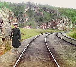 Bashkir switchman near the town Ust' Katav on the Yuryuzan River between Ufa and Chelyabinsk in the Ural Mountains region, c. 1910
 -
 View from the rear platform of the Simskaia railway station of the Samara–Zlatoust Railway, c. 1910
 -
 Almost every station on Trans-Siberian Railway has food sellers, often local vendors who sell local food such as fish (like Baikal omul), pirozhki, and potatoes. Besides food stands, there are also small kiosks.
 -
 Snow in late April at Nazyvayevsk station, Siberia
 -
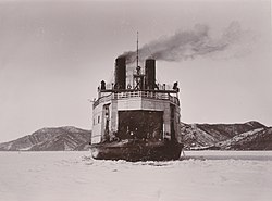 The icebreaking train ferry SS Baikal in service on Lake Baikal
 -
 Train entering a Circum-Baikal tunnel west of Kultuk
 -
 Vladivostok terminus of the Trans-Siberian Railway
 -
 The marker for kilometer 9,288 (mile 5,771.3) at the end of the Trans-Siberian Railway at Vladivostok railway station
 -
 Bridge over the Kama River, near Perm, built in 1912


Routes
[edit]Trans-Siberian line
[edit]A commonly used main line route is as follows. Distances and travel times are from the schedule of train No. 002M, Moscow–Vladivostok.[6]
| Location | Distance | Travel Time |
Time Zone | Notes |
|---|---|---|---|---|
| Moscow, Yaroslavsky Rail Terminal | 0 km (0 mi) | Moscow Time (MT) |
||
| Vladimir | 210 km (130 mi) | MT | ||
| Nizhny Novgorod | 461 km (286 mi) | 6 hours | MT | On the Volga River |
| Kirov | 917 km (570 mi) | 13 hours | MT | On the Vyatka River |
| Perm | 1,397 km (868 mi) | 20 hours | MT+2 | On the Kama River |
| Yekaterinburg | 1,816 km (1,128 mi) | 1 day 2 hours | MT+2 | In the Urals, still called by its old Soviet name Sverdlovsk in most timetables |
| Tyumen | 2,104 km (1,307 mi) | MT+2 | ||
| Omsk | 2,676 km (1,663 mi) | 1 day 14 hours | MT+3 | On the Irtysh River |
| Novosibirsk | 3,303 km (2,052 mi) | 1 day 22 hours | MT+4 | On the Ob River; Turk-Sib railway branches from here |
| Krasnoyarsk | 4,065 km (2,526 mi) | 2 days 11 hours | MT+4 | On the Yenisei River |
| Taishet | 4,483 km (2,786 mi) | MT+5 | Junction with the Baikal-Amur Mainline | |
| Irkutsk | 5,153 km (3,202 mi) | 3 days 4 hours | MT+5 | Near Lake Baikal's southern extremity |
| Ulan Ude | 5,609 km (3,485 mi) | 3 days 12 hours | MT+5 | Eastern shore of Lake Baikal |
| Junction with the Trans-Mongolian line | 5,622 km (3,493 mi) | |||
| Chita | 6,166 km (3,831 mi) | 3 days 22 hours | MT+6 | |
| Junction with the Trans-Manchurian line at Tarskaya | 6,274 km (3,898 mi) | MT+6 | ||
| Birobidzhan | 8,312 km (5,165 mi) | 5 days 13 hours | MT+7 | Capital of the Jewish Autonomous Region |
| Khabarovsk | 8,493 km (5,277 mi) | 5 days 15 hours | MT+7 | On the Amur River |
| Ussuriysk | 9,147 km (5,684 mi) | MT+7 | Junction with the Trans-Manchurian line and Korea branch; located in Baranovsky, 13 km (8 miles) from Ussuriysk | |
| Vladivostok | 9,289 km (5,772 mi) | 6 days 4 hours | MT+7 | On the Pacific Ocean |
| Services to North Korea continue from Ussuriysk via: | ||||
| Primorskaya station | 9,257 km (5,752 mi) | 6 days 14 hours | MT+7 | |
| Khasan | 9,407 km (5,845 mi) | 6 days 19 hours | MT+7 | Border with North Korea |
| Tumangang | 9,412 km (5,848 mi) | 7 days 10 hours | MT+6 | North Korean side of the border |
| Pyongyang | 10,267 km (6,380 mi) | 9 days 2 hours | MT+6 | |
There are many alternative routings between Moscow and Siberia. For example:
.jpg)
- Some trains would leave Moscow from Kazansky Rail Terminal instead of Yaroslavsky Rail Terminal; this would save some 20 km (12 mi) off the distances, because it provides a shorter exit from Moscow onto the Nizhny Novgorod main line.
- One can take a night train from Moscow's Kursky Rail Terminal to Nizhny Novgorod, make a stopover in the Nizhny and then transfer to a Siberia-bound train
- From 1956 to 2001 many trains went between Moscow and Kirov via Yaroslavl instead of Nizhny Novgorod. This would add some 29 km (18 mi) to the distances from Moscow, making the total distance to Vladivostok at 9,288 km (5,771 mi).
- Other trains get from Moscow (Kazansky Terminal) to Yekaterinburg via Kazan.
- Between Yekaterinburg and Omsk it is possible to travel via Kurgan Petropavlovsk (in Kazakhstan) instead of Tyumen.
- One can bypass Yekaterinburg altogether by traveling via Samara, Ufa, Chelyabinsk and Petropavlovsk; this was historically the earliest configuration.
Depending on the route taken, the distances from Moscow to the same station in Siberia may differ by several tens of km (a few dozen miles).
Trans-Manchurian line
[edit]The Trans–Manchurian line, as e.g. used by train No.020, Moscow–Beijing[43] follows the same route as the Trans-Siberian between Moscow and Chita and then follows this route to China:
- Branch off from the Trans-Siberian-line at Tarskaya (6,274 km (3,898 mi) from Moscow)
- Zabaikalsk (6,626 km (4,117 mi)), Russian border town; there is a break-of-gauge
- Manzhouli (6,638 km (4,125 mi) from Moscow, 2,323 km (1,443 mi) from Beijing), Chinese border city
- Harbin (7,573 km (4,706 mi), 1,388 km) Chinese city
- Changchun (7,820 km (4,859 mi) from Moscow) Chinese city
- Beijing (8,961 km (5,568 mi) from Moscow) the Chinese capital
The express train (No. 020) travel time from Moscow to Beijing is just over six days. There is no direct passenger service along the entire original Trans-Manchurian route (i.e., from Moscow or anywhere in Russia, west of Manchuria, to Vladivostok via Harbin), due to the obvious administrative and technical (gauge break) inconveniences of crossing the border twice. Assuming sufficient patience and possession of appropriate visas, however, it is still possible to travel all the way along the original route, with a few stopovers (e.g. in Harbin, Grodekovo and Ussuriysk).[citation needed]
Such an itinerary would pass through the following points from Harbin east:
- Harbin (7,573 km (4,706 mi) from Moscow)
- Mudanjiang (7,928 km (4,926 mi))
- Suifenhe (8,121 km (5,046 mi)), the Chinese border station
- Grodekovo (8,147 km (5,062 mi)), Russia
- Ussuriysk (8,244 km (5,123 mi))
- Vladivostok (8,356 km (5,192 mi))
Trans-Mongolian line
[edit]The Trans–Mongolian line follows the same route as the Trans-Siberian between Moscow and Ulan Ude, and then follows this route to Mongolia and China:
- Branch off from the Trans-Siberian line (5,655 km (3,514 mi) from Moscow)
- Naushki (5,895 km (3,663 mi), MT+5), Russian border town
- Russian–Mongolian border (5,900 km (3,666 mi), MT+5)
- Sükhbaatar (5,921 km (3,679 mi), MT+5), Mongolian border town
- Ulaanbaatar (6,304 km (3,917 mi), MT+5), the Mongolian capital
- Zamyn-Üüd (7,013 km (4,358 mi), MT+5), Mongolian border city
- Erenhot (842 km (523 mi) from Beijing, MT+5), Chinese border city
- Datong (371 km (231 mi), MT+5) Chinese city
- Beijing (MT+5) the Chinese capital
Highest point
[edit]The highest point of Trans–Siberian Railroad is at Yablonovy pass at an altitude of 1070m situated in the Yablonoi Mountains, in Transbaikal (mainly in Zabaykalsky Krai), Siberia, Russia. The Trans–Siberian Railroad passes the mountains at Chita and runs parallel to the range before going through a tunnel to bypass the heights.[44]
See also
[edit]- Baikal–Amur Mainline
- Famous trains
- History of Siberia
- Russian gauge
- Russian Railways
- Sibirjak
- Starlight Express, a train musical in which a character is modeled on the Trans-Siberian Express.
- Trans-Siberian Railway Panorama
- Eastbound
Notes
[edit]- ^ Russian: Транссибирская магистраль, romanized: Transsibírskaya magistrál, pronounced [trənsːʲɪˈbʲirskəjə məɡʲɪˈstralʲ]
- ^ Великий Сибирский Путь, Velíkiy Sibírskiy Put, pronounced [vʲɪˈlʲikʲɪj sʲɪˈbʲirʲsʲkʲɪj putʲ]
- ^ /ˈtrænsɪb/ TRAN-sib; Транссиб, pronounced [trɐnˈsːʲip]
References
[edit]- ^ "Lonely Planet Guide to the Trans-Siberian Railway" (PDF). Lonely Planet Publications. Archived from the original (PDF) on September 5, 2012.
- ^ Thomas, Bryn; McCrohan, Daniel (2019). Trans-Siberian Handbook: The Guide to the World's Longest Railway Journey with 90 Maps and Guides to the Route, Cities and Towns in Russia, Mongolia and China (10 ed.). Trailblazer Publications. ISBN 978-1912716081. Retrieved October 15, 2020.
- ^ Meakin, Annette, A Ribbon of Iron (1901), reprinted in 1970 as part of the Russia Observed series (Arno Press/New York Times)(OCLC 118166).
- ^ a b "Russia offers a bridge across history to connect Tokyo to the Trans-Siberian railway". siberiantimes.com. Archived from the original on December 1, 2017. Retrieved December 11, 2017.
- ^ "New 8,400 mile train journey will connect London to Tokyo". The Independent. September 8, 2017. Retrieved November 11, 2020.
- ^ a b "CIS railway timetable, route No. 002, Moscow-Vladivostok". Archived from the original on December 3, 2009.
- ^ Moscow is at UTC+3, Vladivostok is at UTC+10; therefore the line passes through 8 time zones; see map
- ^ "CIS railway timetable, route No. 002, Moscow-Pyongyang". Archived from the original on April 6, 2020.
- ^ "CIS railway timetable, route No. 350, Kiev-Vladivostok". Archived from the original on April 6, 2020.
- ^ a b c d "Trans-Siberian Railroad". December 7, 2023.
- ^ P. E. Garbutt, "The Trans-Siberian Railway." Journal of Transport History 4 (1954): 238–249.
- ^ Alexeev, V.V.; Bandman, M.K.; Kuleshov–Novosibirsk, V. V., eds. (2002). Problem Regions of Resource Type: Economical Integration of European North-East, Ural and Siberia. IEIE. ISBN 5-89665-060-4.
- ^ March, G. Patrick (1996). Eastern Destiny: Russia in Asia and the North Pacific. Praeger/Greenwood. pp. 152–53. ISBN 0-275-95648-2.
- ^ "The Great Siberian Iron Road", The Daily News (London), 30 December 1896, p. 7.
- ^ Davis, Clarence B.; Wilburn, Kenneth E. Jr; Robinson, Ronald E. (1991). "Russia, the Soviet Union, and the Chinese Eastern Railway". Railway Imperialism. Westport, Connecticut: Greenwood Press. p. 140. ISBN 978-0313259661. Archived from the original on April 6, 2020.
- ^ Pleshakov, Constantine (2002). The Tsar's Last Armada: The Epic Journey to the Battle of Tsushima. New York: Basic Books. p. 10. ISBN 0465057926. Archived from the original on June 3, 2019.
- ^ a b c d "Irkutsk: Ice-Breaker "Angara"". Lake Baikal Travel Company. Archived from the original on September 24, 2011. Retrieved September 15, 2011.
- ^ a b c d e Babanine, Fedor (2003). "Circumbaikal Railway". Lake Baikal Homepage. Fedor Babanine. Retrieved September 15, 2011.
- ^ "Russia's legendary Trans-Siberian railroad line completely electrified". Associated Press. December 25, 2002. Archived from the original on September 4, 2015. Retrieved June 14, 2015 – via HighBeam Research.
- ^ Manley, Deborah (2011). The Trans-Siberian Railway: A Traveller's Anthology. Andrews UK Limited. p. xviii.
- ^ Храмков, А. А. (2001). "Железнодорожные перевозки хлеба из Сибири в западном направлении в конце XIX – начале XX вв" [Railroad transportation of bread from Siberia westwards in the late 19th–early 20th centuries]. Предприниматели и предпринимательство в Сибири. Вып.3 [Entrepreneurs and business undertakings in Siberia. 3rd issue]. Barnaul: Изд-во АГУ. ISBN 5-7904-0195-3. Archived from the original on September 30, 2007. Retrieved July 1, 2006.
- ^ Subtelny, Orest (2000). Ukraine: a history. University of Toronto Press. p. 262. ISBN 0-8020-8390-0.
- ^ Dronin, N. M.; Bellinger, E. G. (2005). Climate dependence and food problems in Russia, 1900–1990: the interaction of climate and agricultural policy and their effect on food problems. Central European University Press. p. 38. ISBN 963-7326-10-3.
- ^ Christian Wolmar, Blood, iron, and gold: How the railroads transformed the world (Public Affairs, 2011), pp 169–70.
- ^ Isitt, Benjamin (2006). "Mutiny from Victoria to Vladivostok, December 1918". Canadian Historical Review. 87 (2): 223–64. doi:10.3138/chr/87.2.223. Retrieved October 3, 2016.
- ^ Kšiňan, Michal (2021). Milan Rastislav Štefánik – Muž, ktorý sa rozprával s hviezdami. Slovart. ISBN 9788055639048.
- ^ Preclík, Vratislav. Masaryk a legie (Masaryk and legions), váz. kniha, 219 str., vydalo nakladatelství Paris Karviná, Žižkova 2379 (734 01 Karviná) ve spolupráci s Masarykovým demokratickým hnutím (Masaryk Democratic Movement, Prague), 2019, ISBN 978-80-87173-47-3, pp. 38–50, 52–102, 104–22, 124–28, 140–48, 184–90
- ^ Willmott, H.P. (2003). First World War. Dorling Kindersley. p. 251.[ISBN missing]
- ^ Martin, Bernd (1969), Deutschland und Japan Im Zweiten Weltkrieg, Musterschmidt Verlag, p. 155
- ^ Lowenstein, Jonathan (April 26, 2010). "The Journey of a Lifetime: my grandmother's escape on the Trans-Siberian railway". Telaviv1.
- ^ "Jan Zwartendijk. – Collections Search – United States Holocaust Memorial Museum".
- ^ "German Intelligence Activities in China during WW I." United States War Department Strategic Services Unit, March 1, 1946
- ^ Martin 1969, p. 174
- ^ Alanbrooke, Field Marshal Lord (2001). War Diaries 1939–1945. Phoenix Press. pp. 607, 608. ISBN 1-84212-526-5.
- ^ Glantz, David M. (1995). When Titans Clashed: How the Red Army Stopped Hitler. Kansas: University Press of Kansas. p. 278. ISBN 0-7006-0899-0.
- ^ Donahue, Patrick (January 24, 2008). "China-to-Germany Cargo Train Completes Trial Run in 15 Days". Bloomberg.com.
- ^ Kachi, Hiroyuki (July 20, 2007). "Mitsui talking to Russian railway operator on trans-Siberian freight service". MarketWatch.com.
- ^ "Trans-Siberian in seven days". Railway Gazette International. May 5, 2009. Archived from the original on November 26, 2020. Retrieved April 9, 2010.
- ^ "Chinese, Russian police nab Trans-Siberian 'great train robbers'". October 20, 1993.
- ^ "In 1993, when a Chinese-Russian train was looted and raped by bandits for several days, the central authorities issued an instruction: cross-border pursuit". December 12, 2021.
- ^ "Beijing to Hamburg fast cargo rail link planned". The China Post. January 11, 2008. Archived from the original on October 30, 2008. Retrieved April 23, 2012.
- ^ "Chapter 4: Freight Rates" (PDF). Review of Maritime Transport. United Nations Conference on Trade and Development: 89. 2010. ISSN 0566-7682. Retrieved December 31, 2011.
- ^ "CIS railway timetable, route No. 020, Moscow-Beijing". Archived from the original on April 6, 2020.
- ^ "Yablonovy Range". Farlex, Inc. Retrieved January 30, 2013.
Travel handbooks
[edit]- Richmond, Simon (2018). Trans-Siberian Railway (6 ed.). London: Lonely Planet. ISBN 978-1-78657-459-6.
- Thomas, Bryn (2014) [1988]. Trans-Siberian Handbook (9 ed.). London: Trailblazer. ISBN 978-1-905864-56-0.
Further reading
[edit]- Ames, Edward (1947). "A century of Russian railroad construction: 1837–1936". American Slavic and East European Review. 6 (3/4): 57–74. doi:10.2307/2491700. JSTOR 2491700.
- Banerjee, Anindita. "The Trans-Siberian Railroad and Russia's Asia: Literature, Geopolitics, Philosophy of History" Clio. Fall2004/Winter2005, Vol. 34 Issue 1/2, pp 19–40.
- Cherkashin, A. "Trans-Siberian railway and interrelation of economic development of regions." IOP Conference Series: Earth and Environmental Science Vol. 190. No. 1. 2018 online.
- Dawson, John W. Jr. (2002). "Max Dehn, Kurt Gödel, and the Trans-Siberian escape route". Notices of the AMS. 49 (9).
- Dmitriev-Mamanov, A.I. and A. F. Zdziarski, eds. Guide to the Great Siberian Railway 1900 (reprinted by David & Charles, 1971), the official guide; also covers the local towns and people. online
- Faulstich, Edith M. (1972–1977). The Siberian Sojourn. Yonkers, New York.
{{cite book}}: CS1 maint: location missing publisher (link) - Garbutt, P. E. "The Trans-Siberian Railway." Journal of Transport History 4 (1954): 238–249.
- Grams, Grant W. (2021). Return Migration of German Nationals from the United States and Canada, 1933–1941 (Jefferson, North Carolina, McFarland Publications_
- Hookham, Hilda. "Builders of the Trans-Siberian Railway" History Today (Aug 1966), Vol. 16 Issue 8, pp. 528–37
- Jefferson, Robert L. Roughing it in Siberia ((Sampson Low, Marston, 1987)
- Marks, S.G. (1991). Road to Power: The Trans-Siberian Railroad and the Colonization of Asian Russia, 1850–1917. Cornell University Press. ISBN 0-8014-2533-6.
- Meakin, Annette M. B. A Ribbon of Iron (BiblioLife, 2009).
- Metzer, Jacob (1976). "Railroads in Tsarist Russia: Direct gains and implications". Explorations in Economic History. 13 (1): 85–111. doi:10.1016/0014-4983(76)90006-1.
- Miller, Elisa B. (1978). "The Trans-Siberian landbridge, a new trade route between Japan and Europe: issues and prospects". Soviet Geography. 19 (4): 223–43. doi:10.1080/00385417.1978.10640225.
- Mironova, Marina Nikolaevna, Natalia Gennadievna Kuznetsova, and Aleksandr Nikolaevich Sholudko. "Types of cities of the Trans-Siberian railway: Dynamics of population and industrial functions." RUDN Journal of Economics 25.4 (2017): 553–565.
- North, Robert N. (1979). Transport in western Siberia: Tsarist and Soviet development. University of British Columbia Press.
- Pepe, Jacopo Maria. "The "Eastern Polygon" of the Trans-Siberian rail line: a critical factor for assessing Russia's strategy toward Eurasia and the Asia-Pacific." Asia Europe Journal 18.3 (2020): 305–324.
- Read, Arnot. From Peking to Petersburg (BiblioLife, 2009
- Reichman, Henry (1988). "The 1905 Revolution on the Siberian Railroad". Russian Review. 47 (1): 25–48. doi:10.2307/130442. JSTOR 130442.
- Richmond, Simon (2009). Trans-Siberian Railway. Lonely Planet. Guide book for travelers
- Sahi, Juha. "The Trans-Siberian railway as a corridor of trade between Finland and Japan in the midst of world crises." Journal of Transport History 36.1 (2015): 58–76.
- Thomas, Bryn (2003). The Trans-Siberian Handbook (6th ed.). Trailblazer. ISBN 1-873756-70-4. Guide book for travelers
- Tupper, Harmon (1965). To the great ocean: Siberia and the Trans-Siberian Railway. Little, Brown., wide-ranging popular history.
- Westwood, John Norton (1964). A history of Russian railways. G. Allen and Unwin.
- Калиничев, В.П. (1991). Великий Сибирский путь (историко-экономический очерк) (in Russian). Москва: Транспорт. ISBN 5-277-00758-X.
- Omrani, Bijan (2010). Asia Overland: Tales of Travel on the Trans-Siberian and Silk Road. Odyssey Publications. ISBN 978-962-217-811-3.
- Walker, Robert. The Trans-Siberian Railway Encyclopedia. Archived from the original on July 12, 2017.
- Wolmar, Christian (2013). To the Edge of the World: The Story of the Trans-Siberian Express, the World's Greatest Railroad. London: Atlantic Books. ISBN 978-0857890375.
External links
[edit]- Trans-Siberian Railway, National Geographic Expeditions website
- Trans-Siberian Railway: a view from Moscow to Vladivostok – a photo essay (27 December 2016), The Guardian. Photographs of "life on board the Trans-Siberian Railway, and beyond the carriage window".
- Russian Railways official website
- Overview of passenger travel today
- "A 1903 map of Trans-Siberian railway".
- Guide to the Great Siberian Railway (1900)
- Mikhailoff, M. (May 1900). . the North American Review. 170 (522).
- Manley, Deborah, ed. (2009). The Trans-Siberian Railway: A Traveller's Anthology. Signal Books. ISBN 978-1-904955-49-8. Archived from the original on March 5, 2012.
- Winchester, Clarence, ed. (1936), "The Trans-Siberian Express", Railway Wonders of the World, pp. 451–57 illustrated description of the route and the train
- Trans-Siberian Train № 1 "Russia". Depart Fast Train on YouTube
- List of cities (with photos) most visited by tourists traveling along the Trans-Siberian Railway
| International | |
|---|---|
| National | |
| Geographic | |
| Other | |
Trans-Siberian Railway
View on GrokipediaRoute and Geography
Main Route Description
The main route of the Trans-Siberian Railway extends from Moscow to Vladivostok, covering a distance of 9,289 kilometers (5,772 miles), establishing it as the longest continuous railway line globally.[6][7] Departing from Yaroslavsky railway station in Moscow, the line initially traverses the forested plains and rolling hills of European Russia, passing through cities such as Vladimir (209 km from Moscow) and Nizhny Novgorod (461 km), before entering the Ural Mountains near Perm (1,397 km) and Yekaterinburg (1,778 km), where it crosses the continental divide at an elevation of approximately 1,040 meters, the route's highest point.[8][9] Further eastward, the railway penetrates the expansive Siberian taiga, characterized by dense coniferous forests, permafrost zones, and vast river systems, including crossings of the Ob, Irtysh, and Yenisei rivers. Major stops in Western Siberia include Tyumen (2,144 km), Omsk (2,456 km), and Novosibirsk (3,306 km), the latter serving as a key industrial and transportation hub amid the region's steppe and woodland landscapes.[10] The line continues through Krasnoyarsk (4,018 km), situated along the Yenisei River, before reaching Eastern Siberia near Irkutsk (5,189 km), which provides access to Lake Baikal's southern shores via branch lines, though the main route skirts the lake to the south without direct circumvention of its circumference.[8][11] In the Transbaikal region, the terrain shifts to more arid steppes and mountainous passes, with stops at Ulan-Ude (5,621 km) and Chita (6,165 km), where the railway navigates seismic-prone areas and bridges over tributaries of the Amur River basin. The final segment enters the Russian Far East, crossing the Amur River via a 2.6-kilometer bridge at Khabarovsk (8,493 km), and proceeds through the Ussuri taiga and Primorsky Krai's hilly forests to terminate at Vladivostok station on the Pacific coast.[8][10] Throughout its length, the route spans eight time zones, traverses 87 cities, and bridges 16 major rivers, facilitating both passenger and freight transport across Russia's longitudinal expanse.[9]Branches and International Extensions
The Baikal-Amur Mainline (BAM), a 4,324 km parallel route to the Trans-Siberian, diverges at Taishet (4,283 km from Moscow) and rejoins the main line near Komsomolsk-on-Amur before connecting to Khabarovsk, providing a northern alternative through rugged taiga and mountainous terrain.[12] [13] Initiated in 1974 under Soviet directives for military redundancy against potential Chinese threats, construction spanned decades with major segments operational by 1984 and full through-traffic enabled in 1989, at a cost exceeding $30 billion adjusted for inflation.[14] [15] The BAM supports freight transport of timber, coal, and minerals, with capacity expansions ongoing as of 2024 to handle up to 180 million tons annually by 2030.[16] International extensions facilitate cross-border connectivity, primarily for passenger and freight services to East Asia. The Trans-Mongolian route branches southward from Ulan-Ude (5,655 km from Moscow), crossing into Mongolia at Naushki-Sukhbaatar, passing through Ulaanbaatar, and entering China at Dzamyn Üüd-Erlian before reaching Beijing, totaling 7,621 km from Moscow.[17] This jointly operated line, leveraging the Ulaanbaatar Railway established in 1949, follows historic tea caravan paths and accommodates weekly trains like Moscow-Beijing No. 4.[18] The Trans-Manchurian route, diverging near Tarskaya (6,274 km from Moscow) toward Zabaikalsk, connects via Manzhouli to the Chinese Eastern Railway's northern branch, traversing Harbin and Changchun to Beijing over 8,986 km.[19] Built by Russia from 1897 to 1902 as a shortcut avoiding Mongolia, this extension was concessioned to China in 1952 but remains integral for Russian-Chinese freight, including oil and grain shipments.[20] A shorter extension links Khasan (9,262 km from Moscow) to Rajin (Rason) in North Korea, spanning 54 km with gauge conversion facilities, enabling direct Moscow-Pyongyang services of 10,214 km resumed in June 2025 after a COVID-19 hiatus from 2020.[21] [22] Primarily freight-oriented for coal and seafood exchanges, the link supports bilateral trade amid sanctions, with modernization at Tumangang yard completed in 2024.[23]History
Planning and Imperial Construction (1891–1916)
The concept of a railway linking European Russia to the Pacific coast emerged in the mid-19th century amid Russian expansion into Siberia, driven by needs for faster troop deployment, resource extraction, and settlement amid threats from Britain and Japan.[24] Formal planning accelerated in the 1880s, with feasibility studies emphasizing economic integration of Siberia's vast timber, minerals, and agricultural potential, though initial proposals faced resistance due to immense costs estimated at hundreds of millions of rubles.[24] By 1890, Tsar Alexander III approved the project as the Great Siberian Way, prioritizing state control over private enterprise to ensure strategic alignment with imperial defense and colonization goals.[2] Construction commenced on May 31, 1891, with the ceremonial laying of the first stone at Vladivostok, under the oversight of the Ministry of Ways of Communication; simultaneous work began at Chelyabinsk in the Urals to build eastward in segments.[2] Sergei Witte, appointed Minister of Finance in 1892, became the project's chief advocate, securing French loans totaling over 150 million rubles by 1894 and integrating railway development into broader industrialization policies, including tariff protections and currency stabilization to fund the endeavor without excessive taxation.[25] Witte's vision framed the railway as a catalyst for Siberia's economic awakening, projecting annual freight volumes of millions of tons to exploit fur, gold, and grain exports, though critics within the bureaucracy highlighted underestimations of terrain difficulties.[26] Engineering hurdles dominated the effort, spanning 9,289 kilometers of tundra, permafrost, dense taiga, and over 300 river crossings, where seasonal floods and subzero temperatures (-50°C) halted progress and demanded innovative techniques like piled foundations to counter soil instability.[3] Labor shortages plagued the sites, relying on 60,000-80,000 convicts, soldiers, and peasants annually, supplemented by imported Chinese workers, amid outbreaks of scurvy and typhoid that claimed thousands of lives; material scarcity forced lighter rails (initially 16-20 kg/m) and wooden bridges vulnerable to decay.[3] The Circum-Baikal section (1896-1904), skirting Lake Baikal's rocky shores, required 500+ tunnels and galleries hand-dug without explosives in parts, exemplifying the era's resource constraints.[24] By 1903, the main line reached Vladivostok via temporary ferries across Baikal, enabling the first through train from St. Petersburg on July 1, but the direct Amur Railway—bypassing Chinese territory amid Russo-Japanese War tensions—lagged due to border disputes and swampy terrain, incorporating 2,000+ bridges and viaducts.[9] Under Tsar Nicholas II, construction intensified post-1905 Revolution, with Witte's successors allocating additional state funds despite fiscal strains from war indemnities.[25] The Amur section's completion on October 5, 1916, marked the railway's full operationalization, after 25 years and expenditures exceeding 1.5 billion rubles, solidifying Russia's transpacific connectivity but exposing imperial overextension in logistics and maintenance.[24]Early Operations and Imperial Impacts
The Trans-Siberian Railway initiated partial operations as individual sections opened in the late 1890s, with the Ussuri line from Vladivostok to Khabarovsk enabling regular traffic by November 1897.[2] Subsequent segments, including the West Siberian Railway from Chelyabinsk to the Ob River completed in 1896 and the Central Siberian line to Irkutsk by 1900, allowed for increasing freight and passenger movement, primarily consisting of agricultural goods, timber, and mining outputs eastward alongside initial settler transports.[24] By 1903, the route supported growing cargo volumes to the Russian Far East, with railway data indicating enhanced supply chains for regional trade despite single-track limitations and seasonal disruptions from permafrost and rivers.[27] The railway's early military deployment during the Russo-Japanese War of 1904–1905 exposed its operational constraints, as the incomplete network—lacking the full Circum-Baikal bypass until 1905 and reliant on ferries across Lake Baikal—restricted troop reinforcements to under 1 million soldiers over the conflict, far below requirements for effective logistics.[28] Single-track bottlenecks and priority given to military convoys halted civilian freight, reducing grain and coal shipments by up to 50% in affected periods and contributing to supply shortages that factored into Russia's defeats in Manchuria.[24] Post-war assessments highlighted how these deficiencies undermined imperial projections of power into East Asia, prompting investments in doubling tracks but revealing the line's initial inadequacy for rapid mobilization against agile naval threats.[29] Economically, the railway facilitated resource extraction and export from Siberia, with early traffic boosting shipments of gold from the Lena fields and timber to Pacific ports, yet its impact on broader development remained limited due to high construction costs exceeding 1.5 billion rubles by 1916 and persistent underpopulation along the route.[30] Imperial policies leveraged the line for peasant resettlement under Stolypin reforms from 1906, transporting over 2 million migrants to eastern lands by 1914, which increased agricultural output in fertile zones but saw high return rates—up to 60%—owing to isolation, poor soil in some areas, and inadequate support infrastructure.[31] Geopolitically, completion of the Amur bypass in October 1916 secured sovereignty over the route, reducing reliance on Chinese Eastern Railway concessions and enabling direct access to Vladivostok, though pre-war analyses cautioned that connectivity to sparsely inhabited territories yielded marginal gains in imperial cohesion compared to European core investments.[32][31]Revolutionary Upheaval and Civil War (1917–1922)
The October Revolution of November 7, 1917 (October 25 Old Style), enabled Bolshevik forces to consolidate power in central Russia, but control over the Trans-Siberian Railway remained contested, serving as a critical artery for transporting troops, supplies, and revolutionaries to Siberia.[33] Bolshevik agittrains, known as agitpoezdy, traversed the line to propagate ideology and mobilize support, with at least 20 such trains operational by 1918, equipped with printing presses, cinemas, and loudspeakers to reach remote stations.[34] These efforts faced resistance from anti-Bolshevik elements, including local Soviets and White forces, who sabotaged tracks and seized rolling stock to disrupt Red movements. In spring 1918, the Czechoslovak Legion—comprising approximately 50,000 Czech and Slovak ex-POWs seeking repatriation via Vladivostok—clashed with Bolshevik authorities after orders to disarm them at Chelyabinsk on May 14, 1918, sparking a revolt that granted the Legion effective control over much of the Trans-Siberian Railway from the Volga region to the Pacific.[35] By mid-July 1918, Legion forces, allied with White Russian units, had captured key cities along the route, including Samara, Kazan, and Irkutsk, clearing Bolshevik garrisons and securing over 6,000 kilometers of track, which facilitated the release of the Romanov family from Tobolsk and the evacuation of Allied supplies stockpiled at the line's eastern depots.[36] This control disrupted Bolshevik logistics, enabling White offensives and prompting Allied interventions; U.S., Japanese, British, and other Entente troops arrived in Siberia from August 1918 to guard the railway and protect munitions worth millions, with American forces alone numbering about 8,000 by September, focused on preventing Japanese expansion and Bolshevik seizures.[37] The railway became a linchpin for Admiral Alexander Kolchak's White government in Omsk, established November 18, 1918, as the Legion guarded the line against Red incursions, transporting Kolchak's Siberian Army eastward for counteroffensives that peaked in spring 1919 with advances to the Urals.[38] However, supply shortages, desertions, and Czech fatigue—exacerbated by the Legion's odyssey, which involved fighting Bolsheviks, Ataman Semenov's Cossacks, and internal White rivalries—led to a retreat; by January 1920, Reds under Mikhail Tukhachevsky recaptured Omsk, forcing Kolchak's flight along the Trans-Siberian to Irkutsk, where he was handed over to Bolsheviks on January 15, 1920, and executed February 7.[39] Extensive sabotage, including derailed trains and destroyed bridges, reduced capacity; for instance, Bolshevik forces demolished locomotives at Soroka in 1919 to hinder Allied evacuations, while White retreats left sections inoperable.[40] By late 1922, Bolshevik victories, including the capture of Vladivostok on October 25, restored Red dominance over the full 9,289-kilometer route, though war damage necessitated repairs that halted regular service until 1924; the conflict claimed an estimated 500,000 railway workers and civilians in Siberia alone, underscoring the line's role as both a strategic asset and a theater of attrition.[33] Allied withdrawals, completed by 1920 for most forces except Japan (which lingered until 1922), marked the railway's transition to Soviet control, with lingering Japanese occupation of segments like the Trans-Baikal line until their exit.[37]Soviet Era Expansions and World War II
Following the Russian Civil War, which had severely damaged the Trans-Siberian Railway through sabotage, battles, and neglect, the Soviet government initiated reconstruction efforts immediately after the conflict's end in 1922. Most repairs, including restoration of tracks, bridges, and rolling stock, were completed by 1924–1925, enabling the line to resume reliable operations and support economic recovery in Siberia.[41] In the late 1920s, as part of industrialization under the first Five-Year Plan, the Soviets began modernizing the railway, including the initiation of electrification in 1929 to increase capacity and efficiency amid growing freight demands from resource extraction.[42] Track doubling on key sections was also pursued in the 1930s to accommodate heavier military and industrial traffic, requiring substantial investments to counter perceived threats from Japan.[43] During World War II, the Trans-Siberian Railway served critical logistical roles for the Soviet Union. Prior to Operation Barbarossa in June 1941, the Molotov-Ribbentrop Pact facilitated German use of the line for shipping goods to Japan, including strategic materials, bolstering Axis coordination until the pact's collapse.[44] After the German invasion, the railway enabled the rapid transfer of approximately 18 fresh divisions from Siberian and Far Eastern districts to the Moscow front between October and November 1941, contributing decisively to the Soviet defense and counteroffensive by providing battle-hardened troops previously stationed against potential Japanese aggression.[45] It also transported Lend-Lease supplies arriving via Vladivostok from the United States, sustaining Soviet forces on the Eastern Front.[46]Post-Soviet Modernization and Recent Developments
Following the dissolution of the Soviet Union in 1991, the Trans-Siberian Railway experienced a period of underutilization due to economic turmoil and reduced industrial output across Russia. Freight volumes declined sharply in the early 1990s as state-controlled enterprises collapsed, but traffic began to recover in the early 2000s amid stabilizing economic conditions and rising demand for resource exports. By the completion of full electrification in 2002, including the final Khabarovsk-Vladivostok segment, the line's operational efficiency improved, enabling heavier train loads up to 6,000 tons.[42] Russian Railways (RZD) launched comprehensive modernization efforts under the Eastern Polygon program, encompassing the Trans-Siberian and Baikal-Amur Mainline, to boost throughput capacity. Between 2010 and 2019, RZD doubled freight traffic on these lines through track renewals exceeding 5,000 km, addition of 303 km of double track, and station upgrades at 39 locations. The first stage of development, completed in 2022 at a cost of $3.6 billion, further enhanced carrying capacity, with the Baikal-Amur Mainline alone reaching nearly 42 million tons annually by 2024—tripling its volume over the prior decade.[47][48][49][50] Recent initiatives aim to expand the Eastern Polygon's total capacity to 270 million tons by 2032 via a 3.7 trillion ruble investment, including over 2,000 km of new tracks, bridges, and digital signaling systems. However, progress has faced setbacks from Western sanctions post-2022, labor shortages, and a pivot toward Asian markets, resulting in a 15-year low in cargo volumes for 2024 and scaled-back spending to 110 billion rubles in 2025. Despite these challenges, enhancements like heavy-haul trains and cross-border integrations with China continue to support trans-Eurasian freight corridors.[51][52][53][54]Technical Specifications
Engineering Feats and Challenges
The Trans-Siberian Railway's construction entailed surmounting immense geographical barriers across Eurasia, including the Ural Mountains' rocky passes and the expansive Siberian taiga, where engineers devised routes to minimize steep gradients while spanning over 9,289 kilometers of largely undeveloped land.[55] Initial surveys and grading began in 1891, requiring the relocation of 27 million cubic yards of earth in challenging sections east of Lake Baikal alone, achieved through manual labor and rudimentary machinery amid vast distances that strained supply chains for rails, ties, and equipment.[24][55] A primary engineering feat was the erection of bridges over major Siberian rivers, such as the Yenisei and Ob, with structures like the Khabarovsk Bridge—spanning 2,497 meters across the Amur River—employing truss designs adapted from Western practices to withstand seasonal floods and ice flows, completed by 1916 despite material shortages and harsh winters reaching -50°C.[2][56] The line incorporates approximately 497 bridges and 15 tunnels, including viaducts in the Urals that facilitated the transition from European to Asian topography without excessive curvature.[57] The Circum-Baikal segment, hugging Lake Baikal's southern shore for about 100 kilometers, stands as one of the most technically demanding portions, necessitating 33 tunnels totaling 7 kilometers and over 200 small bridges or galleries to navigate sheer cliffs, seismic activity, and unstable talus slopes, with workers blasting through granite and stabilizing embankments against wave erosion and avalanches.[58][24] Construction here, finalized in 1904, involved innovative retaining walls and diversion tunnels to manage groundwater, overcoming initial plans for a ferry crossing due to the lake's depth exceeding 1,600 meters and ice-bound winters.[59] Persistent challenges arose from permafrost in eastern sections, where thawing subsoil caused track subsidence and required elevated gravel embankments or wooden pile foundations to preserve stability, though early designs with lightweight rails (often under 40 kg/m) led to accelerated wear and frequent realignments.[56][30] Extreme climatic variations, including prolonged frosts that froze switches and floods that undermined abutments, compounded logistical hurdles, as remote sites lacked mechanized support, forcing reliance on seasonal labor surges and ad-hoc repairs that delayed full operations until 1916.[30][60]Infrastructure and Track Details
The Trans-Siberian Railway's primary route spans 9,288.2 kilometers from Moscow to Vladivostok, configured as a double-tracked line to accommodate bidirectional traffic.[61] It utilizes the Russian broad gauge of 1,520 mm, which differs from the standard gauge of 1,435 mm used in much of Europe and allows for larger loading capacities but requires break-of-gauge operations at borders.[62] Electrification covers the entire length, predominantly with 25 kV 50 Hz AC overhead catenary systems, though approximately 24% of the network, mainly in western sections, retains 3 kV DC infrastructure.[63][64] Tracks consist of continuous welded rails (typically R65 or heavier profiles) laid on reinforced concrete sleepers, with a ballasted substructure designed to mitigate settlement in permafrost zones through specialized insulation and drainage.[65] The infrastructure incorporates extensive civil engineering features to navigate Siberia's terrain, including 3,901 bridges totaling significant aggregate length and 21 tunnels spanning 47 kilometers.[66][17] Notable structures include the 2,612-meter Khabarovsk Bridge over the Amur River, a critical steel truss span completed in 1916 and modernized for heavy loads.[41] Operational speeds are capped at 100–120 km/h for long-distance passenger services and 80–90 km/h for freight trains, reflecting constraints from curvature, gradients up to 9‰, and seasonal icing.[67]| Key Track Specifications | Details |
|---|---|
| Total Length | 9,288.2 km (double-tracked)[61] |
| Gauge | 1,520 mm[62] |
| Electrification | 25 kV 50 Hz AC (majority); 3 kV DC (western sections)[63] |
| Rail Type | Continuous welded rails on concrete sleepers with ballast[65] |
| Max Gradient | 9‰ (0.9%) |
| Passenger Speed Limit | 100–120 km/h[67] |
| Freight Speed Limit | 80–90 km/h[67] |