
Community hub
Recent from talks
Contribute something
Nothing was collected or created yet.
Wembley
View on Wikipedia
Wembley (/ˈwɛmbli/) is a district in the London Borough of Brent, north-west London, 8 miles (13 km) northwest of Charing Cross. It includes the neighbourhoods of Alperton, Kenton, North Wembley, Preston, Sudbury, Tokyngton and Wembley Park. The population was 102,856 in 2011.[2]
Key Information


Wembley was for over 800 years part of the parish of Harrow on the Hill in Middlesex. Its heart, Wembley Green, was surrounded by agricultural manors and their hamlets. The small, narrow, Wembley High Street is a conservation area. The railways of the London & Birmingham Railway reached Wembley in the mid-19th century, when the place gained its first church. Slightly south-west of the old core, the main station was originally called Sudbury, but today is known as Wembley Central. By the 1920s, the nearby long High Road hosted a wide array of shops and Wembley was a large suburb of London. Wembley then, within three decades, became an integral outer district of London, in density and contiguity. Wembley formed a separate civil parish from 1894, incorporated as a municipal borough of Middlesex in 1937. In 1965, when local government in London was reformed, the area merged with the Municipal Borough of Willesden, which was separated by the River Brent, to create the London Borough of Brent, one of the 32 local government districts of Greater London.
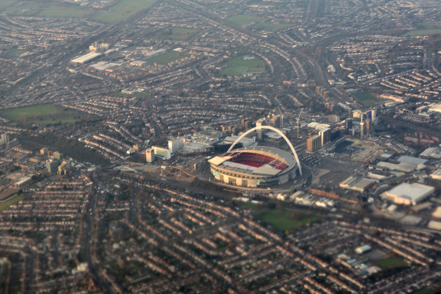
The estate of Wembley Park was largely pleasure grounds when the Metropolitan Railway reached this part in 1894. It was chosen to host the British Empire Exhibition in 1924, resulting in the development of landmarks including the Empire Stadium, later known as Wembley Stadium, which became an iconic football stadium.[3] Suburban protection of public parkland and low-to-mid building density of all but high-rise western Wembley Park means most of Wembley is integral to and archetypal of the once well-advertised – mainly Middlesex – Metroland. After years of debate, the 1923 stadium was replaced by a modernised stadium with a grand, skyline arch which opened in 2007;[3] it is home to the England national football team, hosts latter and/or final stages of annual competitions such as the FA Cup and has the greatest capacity nationwide. In the early 21st century the London Designer Outlet pedestrianised plaza was built.
History
[edit]| ◄ Split from Harrow on the Hill | |
| 1901 | 4,519 |
|---|---|
| 1911 | 10,696 |
| 1921 | 16,187 |
| 1931 | 48,561 |
| ◄ From abolition, 1 April 1934, of Kingsbury Urban District (1,827 acres (7.39 km2)) until 1965 about, that is if static as at 1931, 16,636 residents, absorbed[4] | |
| 1939 | 112,563 |
| 1951 | 131,384 |
| 1961 | 124,892 |
| Note no 1941 census due to war | |
| source: UK census/The 1939 Register[5] | |
Toponymy
[edit]Wembley is derived from the Old English proper name "Wemba" and the Old English "lea" for meadow or clearing. The name was first mentioned in the charter of 825 of Selvin. A further instance may be seen in the Plea Rolls of the Common Pleas, as Wambeleye.[6]
The old manor
[edit]The village of Wembley grew up on the hill by the clearing with the Harrow Road south of it. Much of the surrounding area remained wooded. In 1547 there were but six houses in Wembley. Though small, it was one of the wealthiest parts of Harrow. At the dissolution of the monasteries in 1543, the manor of Wembley fell to Richard Andrews and Leonard Chamberlain, who sold it to Richard Page, Esq., of Harrow on the Hill, the same year. There was a mill on Wembley Hill by 1673.
The Page family continued as lords of the manor of Wembley for several centuries and eventually commissioned Humphry Repton (1752–1818) the landscape gardener to design what is now Wembley Park.[7][8] Wembley Park thus derived its name from Repton's habit of referring to the areas he designed as "parks".
The former Barley Mow pub was recorded in 1722 thus was the earliest long-lasting pub of Wembley.[9]
Railways, parish formed and development
[edit]In 1837, the London & Birmingham Railway (now part of the West Coast Main Line) was opened from London Euston through Wembley to Hemel Hempstead, and completed to Birmingham Curzon Street the following year. The changing names of the local station demonstrated the increasing importance of the 'Wembley' name. 'Sudbury' station opened in 1845, renamed as 'Sudbury and Wembley' in 1882, renamed as 'Wembley for Sudbury' in 1910, renamed as 'Wembley Central' in 1948, at the time of the Olympic Games.

To modernise the service, a new Watford DC line was built alongside the main lines and Bakerloo line trains, and electric trains to Broad Street started in 1917. Electric trains to London Euston began running in 1922. Since 1917, there have been six platforms at what is now Wembley Central station. In 1880, the Metropolitan Railway opened its line from Baker Street through the eastern side of Wembley, but only built a station, Wembley Park, in 1894. There are now three physically separate services, the London to Aylesbury Line, the Metropolitan line and the Jubilee line. Only the latter two services have platforms at Wembley Park station.
Anne and Frances Copland, who in 1843 inherited Sudbury Lodge and its lands, gave a plot for a church to serve the southern part of Harrow parish.[10] In spite of less support from local farmers, who preferred part of Lord Northwick's property on Wembley Hill, the sisters' offer was accepted since they would bear all the cost of building.[10] The church of Saint John the Evangelist, Wembley, designed by George Gilbert Scott and W. B. Moffatt, was consecrated in 1846, in which year Wembley became a parish.[10] It was built of flint with stone dressings, in the Gothic style, and comprised chancel, nave, northeast chapel, and wooden bell turret.[10] A north aisle was added in 1859 and a south aisle in 1900; extensions were made to the west to designs of G. P. Pratt in 1935.[10] It has one church bell.[10]

In November 1905, the Great Central Railway (now, in this section, part of the Chiltern Main Line) opened a new route for fast expresses that by-passed the congested Metropolitan Railway tracks. It ran between Neasden Junction, south of Wembley, and Northolt Junction, west of London, where a new joint main line with the Great Western Railway began. Local passenger services from London Marylebone were added from March 1906, when new stations were opened, including 'Wembley Hill', next to what later became the site of Wembley Stadium – the national stadium of English sport – which opened for the FA Cup Final of April 1923, remaining open for 77 years until it closed for reconstruction in October 2000.[11] After a long planning and redevelopment process dogged by a series of funding problems and construction delays, the new stadium finally opened its doors in March 2007.[12] Wembley Hill station was renamed 'Wembley Complex' in May 1978, before getting its present name of 'Wembley Stadium' in May 1987.[13]
Wembley was also served by tram (route 62) and later trolleybus (route 662) which ran through the Harrow Road from Sudbury to Paddington until the abandonment of the networks.[14] The route is now mostly served by bus route 18 which is also one of the busiest bus routes in all of London today.[15]

The 1937-built fire brigade headquarters of Middlesex County Council on Harrow Road, in Moderne style, is now a fire station of the London Fire Brigade. It is statutorily recognised and protected in the initial category, Grade II, of listed building.[16]
Wembley, in common with much of northwest London, had an extensive manufacturing industry, but much of it closed in the 1980s. Its factories included Glacier Metals (bearings), Wolf Power Tools, Sunbeam Electrical Appliances, Griffin & George (laboratory equipment) and GEC (whose research laboratories, opened in 1923, were one of the first of their type in the United Kingdom[17]).
Empire Exhibition and the Stadium
[edit]
What had been Wembley Park hosted the British Empire Exhibition[18][19][20] of 1924–1925.[21][22][23][24] Until the 2000s, remnants of the many reinforced concrete buildings, including the original Wembley Stadium, remained, but nearly all have now been removed, to make way for redevelopment.
Most of the rest of Wembley's housing consists of inter-war semi-detached houses and terraces and of modern apartment blocks, with a significant minority of detached houses.
Expansion in the town centre continued. In 1929 the Majestic Theatre was opened, later becoming Odeon Wembley cinema. It closed in 1961 and was demolished, replaced by a C&A store (today a Wilko store).[25] Another cinema in the town was an ABC cinema originally opened as The Regal in 1937, on Ealing Road, which operated until 1976. After this it operated for some years as an independent cinema showcasing Bollywood films. The building was demolished in 1987.[26]
Post-war
[edit]
During the 1960s, rebuilding of Wembley Central station, a block of flats, an open-plan shopping plaza, and a car park were constructed on a concrete raft over the railway. The retail centre of Wembley (the High Road and north end of Ealing Road) has suffered from chronic traffic congestion and from the opening of neighbouring purpose-built shopping centres, first Brent Cross Shopping Centre in the 1970s and later the Harrow and Ealing Broadway shopping centres.
Following continuing decline, Wembley had become unattractive and increasingly derelict by the century's end. However the large Indian community in the town maintained a growing jewellery market with their shops on Ealing Road.[27]
A British Army recruitment centre led away from the High Road and came under attack by an IRA bomb in 1990, seeing a soldier die and four people injured (see 1990 Wembley bombing).[28]
Recent regenerations
[edit]

The town's regeneration is one of the major development projects in London in the early 21st century, as specified in the London Plan published by the Mayor of London Ken Livingstone in 2004. A shopping plaza along High Road, an attractive shopping district in the 1950s, suffered slow decline by the 1980s and was therefore poorly maintained.[27] Its Marks & Spencer department store closed in 2005 after 71 years trading.[29]
In a bid to reverse Wembley's fortunes, in the mid-2000s plans were created and approved to completely regenerate the place, carried out by construction company St. Modwen. The first phase, including construction of eighty-five homes, reconstruction of the plaza as a new public square and opening of new retail units including a TK Maxx, was completed in 2009.[30][31] The rest was completed in phases until 2015 after nine years' time, with additional retail and housing units.[32] The local Argos store also moved to a new unit in the redeveloped Central Square.
Purpose-built Brent Civic Centre near the stadium was completed in 2013, with all Brent administration moving to this complex. As a result, other offices were closed. The Chesterfield House block on Park Lane that was used as council offices, built in the 1960s replacing a Methodist church that moved further down the road, was demolished in 2017 and replaced by 21 and 26 storey blocks of apartments.[33][34] Brent House, an office complex on High Road, was sold by the council sold Brent House to a developer called Henley Homes who demolished the building and also replaced it with residential apartments.[35] Mahatma Gandhi House on Wembley Hill Road, another council office block, was also sold off.[36] The listed Brent Town Hall was also disposed and became a French school, Lycée International de Londres Winston Churchill.
The regeneration project is focused on the "Wembley Park" site which includes Wembley Stadium and Wembley Arena, about a mile northeast from Wembley town centre. The Original Wembley Stadium closed in October 2000 and was demolished in 2003.[37] The new Wembley stadium was designed by a consortium including engineering consultant Mott MacDonald and built by the Australian firm Multiplex. It cost £798 million and opened in 2007.[38] Grade II-listed Wembley Arena, now the SSE Arena, has been sensitively refurbished in keeping with its Art Deco style.[39] In 2004, Brent Council approved a mixed use plan by Buro Happold for the development of 55 acres (223,000 m2) adjacent to the stadium, which was presented by Quintain Limited.
Governance
[edit],_Wembley_-_geograph.org.uk_-_865102.jpg)
Wembley falls within the UK Parliament constituency of Brent North, currently represented by Barry Gardiner MP (Labour). It falls within the London Assembly constituency of Brent and Harrow.
Wembley formed part of the large ancient parish of Harrow on the Hill in the Gore hundred of Middlesex. In 1894 Wembley was split from Harrow, creating a new parish and urban district. It included Alperton, Preston, North Wembley, South Kenton, Tokyngton, Sudbury, Wembley Park and Northwick Park. The urban district included the neighbouring parish of Kingsbury until 1901 and again from 1934.
In 1937 it was incorporated as the Municipal Borough of Wembley. Wembley Town Hall on Forty Lane, built in 1938, became Brent Town Hall when the municipal boroughs of Wembley and Willesden were amalgamated in 1965 to form the London Borough of Brent and transferred to Greater London.
Willesden merger and split proposal
[edit]Brent proved to be one of the more unpopular of the mergers occurring during the creation of the modern London boroughs. Reasons for this included the limited road links between the two main areas of Wembley and Willesden (with the A4088 and A404 Harrow Road, the only major road links across the Brent valley boundary), the lack of a focal point or ‘heart’ for the borough and the contrasting characteristics; with Willesden more inner-city in nature, and Wembley more suburban. Widening schemes for the North Circular Road, which passed along the Brent valley, close to the boundary between the two, increased this sense of separation. The clash quickly turned political amid the plans to build Chalkhill Estate, as Wembley was Conservative while Willesden was Labour; the balance of power between the two parties contributed to the borough council becoming a byword for polarised politics.[27]
The unpopularity persisted and in 1989 more than ten thousand people signed a petition calling for Wembley to regain its independence or else join with the London Borough of Harrow with which it had historic administrative links, had better transport integration and had shared common suburban interests. The 1994, the Boundary Commission considered this, and other requests, considering a wide range of options[40] including restoring independence to the districts, or joining them to different neighbouring boroughs – an option the Commission preferred.
Wembley and Harrow were felt to be a natural match, and the London Borough of Harrow supported these proposals and called for a boundary rationalisation with Barnet so that the A5 Road (Watling Street) formed the enlarged borough's entire eastern boundary. Willesden was harder to satisfactorily match with a neighbour, with Ealing considered the most natural choice, the main problem being the lack of a focal point, with the industrial areas of Park Royal, Old Oak Common and North Acton forming a relatively ill-connected barrier between the two. The Commission concluded that there was insufficient justification for the disruption caused by the changes, and that such changes should only be considered during a comprehensive review of London's boundaries.
Geography
[edit]
Until the nineteenth century, Wembley was rural. In broadest terms Wembley has eight main green spaces, all but the golf course being public (no farms or private parks exist). The formal five are King Edward VII Park, set out in 1914 slightly north of the centre (10.5 hectares), Barham Park (10.5 hectares), One Tree Hill Park, Sudbury Green and Brent River Park / Tokyngton Recreation Ground (20.26 hectares) has been restored, returning the river to a more natural course. The informal three are Horsenden Hill, Vale Farm sports ground (30 hectares) and partly horse-grazed Barn Hill (19.9 hectares), east of which is its Kingsbury continuation: Fryent Country Park.
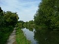
Sudbury Golf Course abuts the Paddington Arm of the Grand Union Canal, with a towpath running into central London. Sudbury Squash and Tennis Club has outdoor tennis courts, an indoor squash court, and a clubhouse. Wembley is a short distance away from the Welsh Harp reservoir and open space, created in the early 19th century by damming the River Brent to provide water for the Grand Union Canal.
Wembley is made up of six wards: Wembley Central, Alperton, Tokyngton, Barnhill, Preston and Sudbury. The town takes up the south-western quarter of the borough of Brent, being west of Harlesden and Willesden and south of Kenton.[41] It is also east of Greenford and Northolt in the neighbouring London Borough of Ealing. The area is identified in the Mayor of London's London Plan as one of thirty-five major centres in Greater London.[42] Wembley is part of both HA0 and HA9 post codes, and has its own post town.
Neighbouring areas of Wembley | |
|---|---|
Demographics
[edit]This section needs to be updated. (August 2024) |

Wembley is known for its high degree of ethnic and religious diversity, and the population includes a large number of people of Asian, Afro-Caribbean and Eastern European origin.[43][44] According to the 1991 census, 49.2% of the Wembley Central ward identified themselves as Asian (39% Indian). The ward along with neighbouring Tokyngton (eastern Wembley) and Alperton were in the top 10 most diverse in London. In the 2001 census, 78.6% of the ward identified themselves as being of black or minority ethnic (BME) groups.[45][46] The White British population of Wembley Central (792 people, 5.3% of the population) in the 2011 census makes it the sixth least White British ward in London (seventh in the country).[47] Other ethnicities include 7.0% Other White, 66.2% Asian (46.2% Indian), and 13.9% Black.[47] In 2011, 86% of Wembley Central ward was of BAME background, which is the highest in Brent and 5th highest in Greater London. In Wembley the lowest BAME ward was Northwick Park, 68.8%.[48]
The 2011 census also showed that, in the Wembley Central ward, the unemployment rate stood at 5.3%. Of the 4,380 households, 2,065 of the properties were tenure owned, 1,469 was privately rented and 684 was socially rented from the council. The largest religion was Hinduism (45%) followed by Christianity (25%). The median age was 32. By far the most spoken foreign language was Gujarati.[49] Wembley Central only covers Wembley town centre and the whole district is represented by five other wards.
There are varying levels of social deprivation in the area. Places such as the central area and Chalkhill have had relatively high deprivation, with the latter having been troubled for a long time. In more recent years, regeneration has helped these areas fare better albeit with a higher general cost of living. Some parts of the town meanwhile are among the least deprived in the borough, especially Barn Hill estate and North Wembley's Sudbury Court Estate.[50][51]
Media
[edit]Local news in Wembley is provided by the Brent & Kilburn Times and the Harrow Times in print and online forms.
Economy
[edit]

The main shopping area was generally centred on Wembley High Road, Central Square, and Ealing Road. Unlike typical British high streets Wembley does not have a town centre network or pedestrianised high streets, with almost all commercial high street businesses along a 1000-yard stretch of road (High Road). In 1971 the High Road was seen as being the 11th best place to shop in London. However, it had fallen to 24th place by 1987.[52] Ealing Road remains important as a centre of South Asian jewellery and gold shops,[53] attracting people from as far afield as Leicester, but otherwise the focus of shopping has shifted north and east to the more recent development of London Designer Outlet[54] in Wembley Park, which is part of the Stadium's complex and also includes a fully pedestrianised street near the Stadium. The regenerations were co-funded by Brent Council to add an attractive shopping destination.[55]
The Wembley Sunday Market was a popular market held weekly from the 1970s until 2014 and run by Wendy Fair Markets. The market was ousted by the landowners, Quintain, in favour of the London Designer Outlet development. The market was then set up at the former Unisys tower near Stonebridge Park station before it was closed within a year by the council citing traffic disruption.[56][57]
IKEA Wembley is in the Brent Park retail area near North Circular Road, Neasden. It opened in 1988 and was the Swedish retailer's second store in the UK after the initial store in Warrington.[58]
The Air France-KLM European Sales and Service Centre, which is a sales channel for 15 European countries, is in Brent Civic Centre in Wembley Park.[59]
Sport and leisure
[edit]Wembley has two local non-League football clubs, Wembley F.C. and South Kilburn F.C., that both play at Vale Farm stadium in nearby Sudbury. Nearby is Vale Farm Sports Centre.
There once were two golf clubs in Wembley. Wembley Golf Club, founded in 1896, was situated north of the Metropolitan Railway line in what is now the Fryent Country Park. The club closed in the late 1920s.[60] Wembley Park Golf Club was founded in 1912 in Sir Edward Watkin's Wembley Park pleasure gardens, improving on the 9-hole course that had opened, along with Watkin's Wembley Park, in 1896. The course itself became the site of the British Empire Exhibition.[61]
The rugby union club, Wasps RFC, was based at Repton Avenue in Sudbury from the 1920s until 1996.
Landmarks
[edit]
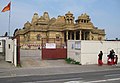
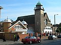
Apart from Wembley's earliest church, which is to St John the Evangelist of 1846 (see above) another listed building is what was Saint Andrew's Presbyterian Church built in 1904, designed by Thomas Collcutt and Stanley Hemp. It is made mainly of brick and the design was influenced by the Arts and Crafts Movement. It is listed in the initial, mainstream, Grade II category since 1993.[62] It was converted into the Central Mosque Wembley in the late 1990s. To the south on Ealing Road is the Shree Sanatan Hindu Mandir, a major mandir opened in 2010.
The Catholic church of Saint Joseph, a post-war church, became equally listed in 2016.[63]
The Ace Cafe is unusually a transport café, opened in 1938 and re-opening in 1997 after decades of closure. This venue has been used to hold and plan car and bike events by motoring enthusiasts, nationally and internationally.[64]
Wembley Point, formerly Station House, is a 21-storey building next to Stonebridge Park station. It was Brent's first skyscraper, built in 1965, and is visible from a radius of several miles. The building has had various uses, including partly as a gym and offices.[65]
Brent's only English Heritage blue plaque is on Forty Lane, commemorating the comedian and entertainer Arthur Lucan.[66][67]

The prime landmark is Wembley Stadium, rebuilt 2003–07 at a cost of £827 million,[68] which is approached via the White Horse Bridge designed by the London Eye architects. About half of the stadium's width northwest is the SSE Arena, a Grade II-listed concert venue built in 1934 as the Empire Pool, a multi-use facility built for the 2nd Empire Games and much renovated. The former Wembley (later Brent) Town Hall is likewise listed on Barn Hill remotely facing Wembley Stadium; it has now been refurbished as a French school, the Lycée International de Londres Winston Churchill.[69] The London Borough of Brent's council chamber and main offices occupy Brent Civic Centre, Engineers Way, Wembley Park.
Transport
[edit]Tube/train
[edit]

Stations in the town are:
- Wembley Stadium (Chiltern Railways)
- Wembley Central (Bakerloo line, Southern, West Midlands Trains and Watford DC line)
- North Wembley (Bakerloo line and Watford DC line)
- Wembley Park (Jubilee line and Metropolitan line)
- Sudbury Town (Piccadilly line)
- Preston Road (Metropolitan line)
- Alperton (Piccadilly line)
- Stonebridge Park (Bakerloo Line and Watford DC line)
Buses
[edit]
Wembley has numerous Transport for London bus routes that run through its centre on High Road, namely routes 18, 79, 83, 92, 182, 204, 223, 224, 297, 483, H17, and night route N18.
Canal
[edit]The Paddington Arm of the Grand Union Canal runs through the south of Wembley.
Road
[edit]Wembley lies very close to the A406 North Circular Road. The A404 Harrow Road passes through its centre. The town centre is served by three pay-and-display car parks.
SSE Arena access
[edit]Wembley Arena is served by Wembley Park station on the London Underground via Olympic Way, Wembley Stadium on the Chiltern Railways line from London Marylebone to Birmingham Snow Hill, and Wembley Central (walking via the White Horse Bridge). Bus route 92 stops directly outside.
The onsite parking facilities are close by, with a multistorey car park called Red Parking and a surface level car park on the eastern flank of the Stadium called Green Parking.[70] Disabled parking is available at a reduced rate but on a first-come first-served basis.[71]
Education
[edit]Notable people
[edit]- British Actor Ricardo P. Lloyd, grew up in Wembley
- Politician Luciana Berger (born 1981), The Independent Group MP, grew up in Wembley.
- Drummer Charlie Watts, founding member of The Rolling Stones, was born in Wembley.
- Engineer and Formula One aerodynamicist, John Barnard, who is credited with introducing the first semi-automatic gearbox, the first carbon fibre composite chassis and the "coke bottle" shape of the rear bodywork, was born in Wembley in 1946.
- Actor Riz Ahmed, star of satirist Chris Morris's black comedy Four Lions (2010), was born in Wembley.
- Scientist John D Barrow, Professor of Mathematical Sciences at Cambridge University, cosmologist, Templeton prize winner and author of many popular science books and the award-winning play Infinities was born in Wembley in 1952 and attended Barham Primary School.
- Composer Peter Fribbins was born, and grew up, in Wembley.
- British ambassador to Israel Matthew Gould grew up in Wembley.
- Astrologer Russell Grant lived in Wembley.
- Scholar Vivian H. H. Green (1915–2005), the model for author John le Carré's spymaster character George Smiley, was born in Wembley.
- Matthew Harrison was born in Wembley in 1979.
- Actor and comedian Lenny Henry lived in Wembley.
- Actor and musician Gary Holton (1952–1985), Wayne in Auf Wiedersehen, Pet and frontman of Heavy Metal Kids, lived in Wembley at the time of his death.
- Footballers Raheem Sterling, Jerel Ifil, and Jerome Thomas lived in Wembley.
- Musician John Lingwood, drummer in Manfred Mann's Earth Band, was born in Wembley.
- The actor Arthur Lucan (Arthur Towle), famous for his performances as 'Old Mother Riley', lived at 11 Forty Lane, Wembley, as did his wife and co-star, Catherine 'Kitty' McShane.
- Rock drummer Keith Moon of The Who, was born in Wembley.
- Singer Maxine Nightingale, best known for her soul hit records in the 1970s, was born in Wembley.
- Figure-skater Valda Osborn was born in Wembley.
- Nurse, journalist, broadcaster and novelist Claire Rayner lived in Wembley.
- Dancer, author, musician and bandleader Victor Silvester was the second son of J. W. P. Silvester, vicar of St. John the Evangelist Anglican church, Wembley.
- Composer John Tavener was born in Wembley.
- Musician Harvey Shield grew up in Wembley.
- Mick Whelan, head of the ASLEF trade union, lives in Wembley.
- Sir Henry Cooper, British Heavyweight Champion, after the key bout with Cassius Clay, 1963, retired to the town of the venue; he opened a greengrocer's shop at the top of Ealing Road, Wembley.
See also
[edit]- Wembley Point Woman, unidentified decedent found at the base of the Wembley Point tower in 2004
Gallery
[edit]-
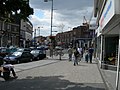 High Road, looking west towards the junction with Park Lane
 -
 Building built as Marks and Spencer outlet, mainly divided in four vertically
 -
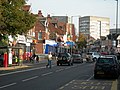 Western section of High Road, looking east
 -
 Shops near the High Road/Wembley Hill Road junction
 -
 Mannions Free House, Irish pub, on High Road
 -
 Wembley Point skyscraper, next to the North Circular Road
 -
 York House and London Designer Outlet
 -
 Bland's, a small department store on High Road that traded from 1911 to 2017
 -
 Wembley Way connects, for pedestrians, Wembley Park Station and Wembley Stadium
 -
 Grand Union Canal Towpath, by Sudbury Golf Course
 -
 Shree Sanatan Hindu Mandir
 -
 Central Mosque, Wembley
 -
 King Edward VII Park
 -
 Barn Hill public open space
_-_geograph.org.uk_-_216336.jpg)


.jpg)


Notes
[edit]References
[edit]- ^ Wembley is made up of 7 wards in the London Borough of Brent: Alperton, Barnhill, Northwick Park, Kenton, Preston, Sudbury, Tokyngton, and Wembley Central. "2011 Census Ward Population Estimates | London DataStore". Archived from the original on 22 February 2014. Retrieved 9 June 2014.
- ^ "2011 Census Ward Population Estimates | London DataStore". Archived from the original on 22 February 2014. Retrieved 9 June 2014.
- ^ a b Architecture, Failed (20 December 2019). "How the British buried their Imperial History along with Wembley Stadium".
- ^ 1931 Census of England and Wales, Table B, 'Areas altered between 26th April, 1931 and 30th June, 1934, showing constitution as at the latter date, in terms of constitution as at the former date, together with particulars of acreage and population'.; M. of H. Order No. 78096. The Middlesex Review Order, 1934; 8.2.1935. M. of H. Declaration under Section 145 of the LGA, 1933
- ^ "Wembley MB/UD through time | Population Statistics | Total Population". Visionofbritain.org.uk. Retrieved 5 October 2021.
- ^ aalt.law.uh.edu; http://aalt.law.uh.edu/E3/CP40no357/aCP40no357mm1toEnd/IMG_7441.htm; third entry, line 3, "apud Wambeleye"; in 1349
- ^ "Harrow on the Hill | British History Online". www.british-history.ac.uk.
- ^ "Harrow, including Pinner : Manors | British History Online". www.british-history.ac.uk.
- ^ "Appraisal" (PDF). brent.gov.uk. Archived (PDF) from the original on 14 March 2020. Retrieved 5 October 2021.
- ^ a b c d e f Diane K Bolton, H P F King, Gillian Wyld and D C Yaxley, 'Harrow, including Pinner : Modern churches', in A History of the County of Middlesex: Volume 4 ed. T F T Baker, J S Cockburn and R B Pugh (London, 1971), pp. 257-260. British History Online http://www.british-history.ac.uk/vch/middx/vol4/pp257-260
- ^ TheFA. "History Introduction". Archived from the original on 17 October 2010. Retrieved 9 October 2010.
- ^ "Doors finally open at new Wembley". BBC News. 17 March 2007.
- ^ Mitchell, Vic; Smith, Keith (February 2005). "Figure 51". Marylebone to Rickmansworth. Midland Main Lines. Midhurst: Middleton Press. ISBN 1-904474-49-7.
- ^ "David Bradley Online - Anniversary Parade of London Tram and Trolleybus abandonment". www.trolleybus.net.
- ^ Peracha, Qasim (8 November 2019). "The 11 busiest bus routes in London where finding a seat is a real challenge". MyLondon.
- ^ Historic England. "Fire Station (1247236)". National Heritage List for England.
- ^ Clayton, Robert; Algar, Joan (1989). The GEC Research Laboratories 1919–1984. Peter Peregrinus. ISBN 0-86341-146-0.
- ^ Photograph of exhibition site[permanent dead link]
- ^ Map of exhibition site[permanent dead link]
- ^ Sunday Tribune of India (newspaper) Article on exhibition (2004)
- ^ British Pathe (agency) Archived 11 June 2011 at the Wayback Machine Film of British Empire Exhibition, reel one
- ^ British Pathe (agency) Archived 11 June 2011 at the Wayback Machine Film of British Empire Exhibition, reel two
- ^ British Pathe (agency) Archived 11 June 2011 at the Wayback Machine Film of British Empire Exhibition, reel three
- ^ British Pathe (agency) Archived 11 June 2011 at the Wayback Machine Film of British Empire Exhibition, reel four
- ^ "Odeon Wembley in Wembley, GB - Cinema Treasures". cinematreasures.org.
- ^ "ABC Wembley in Wembley, GB - Cinema Treasures". cinematreasures.org.
- ^ a b c "Brent Council - History of Wembley and Tokyngton". www.brent.gov.uk.
- ^ "The Observer from London, Greater London, England on June 3, 1990 · 3". Newspapers.com. 3 June 1990.
- ^ Harrison, Stephanie (21 October 2013). "Marks & Spencer returns to Wembley and creates 55 jobs". Kilburn Times.
- ^ Brent Resource and Information Network (BRAIN). "Public square reopens in Wembley Central". Brent Council. Retrieved 25 October 2009.
- ^ "New Public Square Launched at Wembley Central". 9 October 2009.
- ^ "Wembley Central invites you to fun-filled day to mark shop openings". 27 March 2015.
- ^ "Park Lane Methodist Church". www.plmc.org.uk.
- ^ "Chesterfield House". New London Architecture.
- ^ Mansfield, Lucy (17 March 2017). "Parents' shock as building in Wembley crashes down next to school playground". Kilburn Times.
- ^ King, Lorraine (13 July 2015). "New homes bid for former council building in Wembley sold for almost £10m". Kilburn Times.
- ^ "Wembley: Towers to arches". New Civil Engineer. 22 December 2010. Retrieved 3 July 2016.
- ^ Stadium, Wembley. "90 Years of Wembley Stadium | Wembley Stadium". www.wembleystadium.com. Archived from the original on 11 June 2016. Retrieved 3 July 2016.
- ^ "Wembley Arena | John Sisk and Son". www.johnsiskandson.com. Archived from the original on 16 August 2016. Retrieved 3 July 2016.
- ^ "Boundary Commission Report of 1994" (PDF). Archived from the original (PDF) on 23 October 2022. Retrieved 14 November 2020.
- ^ "Wembley". Wembley.
- ^ Mayor of London (February 2008). "London Plan (Consolidated with Alterations since 2004)" (PDF). Greater London Authority. Archived from the original (PDF) on 2 June 2010. Retrieved 2 August 2009.
- ^ "Multiculturalism the Wembley way". 8 September 2005 – via news.bbc.co.uk.
- ^ Khatau, Chelna (15 March 2008). "Big India in little England". DNA India.
- ^ "Archived copy" (PDF). Archived from the original (PDF) on 21 December 2016. Retrieved 21 May 2016.
{{cite web}}: CS1 maint: archived copy as title (link) - ^ "Archived copy" (PDF). Archived from the original (PDF) on 11 June 2016. Retrieved 21 May 2016.
{{cite web}}: CS1 maint: archived copy as title (link) - ^ a b "Wembley Central – UK Census Data 2011". UK Census Data. Retrieved 20 December 2015.
- ^ "Ward Profiles and Atlas – London Datastore".
- ^ "Wembley Central - UK Census Data 2011".
- ^ "Data" (PDF). thinkhouse.org.uk. Archived (PDF) from the original on 19 September 2020. Retrieved 5 October 2021.
- ^ Somerville, Hannah (19 November 2019). "Most 'deprived' areas revealed – new figures show rich-poor divide". Kilburn Times.
- ^ Barres-Baker, M.C. "Places in Brent Wembley and Tokyngton" (PDF). Archived from the original (PDF) on 14 April 2014. Retrieved 3 July 2016.
- ^ "Rallying to the gold standard". 4 June 2002. Archived from the original on 12 January 2022. Retrieved 3 July 2016.
- ^ "Enjoy more things to do in Wembley Park / London Designer Outlet". www.londondesigneroutlet.com. Archived from the original on 23 June 2016. Retrieved 3 July 2016.
- ^ "Action plan" (PDF). brent.gov.uk. Archived (PDF) from the original on 3 January 2020. Retrieved 5 October 2021.
- ^ Jobson, Myron (7 July 2014). "Beloved Wembley Sunday Market closed for the foreseeable future". Kilburn Times.
- ^ Black, Caitlin (7 October 2014). "New market in Wembley opens every Sunday to ensure no fake goods are being sold". MyLondon.
- ^ "The IKEA phenomenon - IKEA's long history with the North West". www.lep.co.uk. 18 May 2018.
- ^ "Air France – Refund request – Official website". AirFrance. Archived from the original on 6 July 2016. Retrieved 3 July 2016.
- ^ "Wembley Golf Club", "Golf's Missing Links".
- ^ Llewellyn, John. "Wembley Park Golf Club, Greater London". www.golfsmissinglinks.co.uk. Retrieved 3 July 2016.
- ^ "St Andrew's Presbyterian Church – Wembley". britishlistedbuildings.co.uk. 2011. Retrieved 13 November 2011.
- ^ "Roman Catholic Church of St Joseph, Non Civil Parish - 1431030 | Historic England". historicengland.org.uk.
- ^ "Ace Cafe facing closure? | Heritage Insurance".
- ^ Kingsley, Thomas (29 May 2020). "The abandoned Wembley skyscraper that's about to be transformed". MyLondon.
- ^ "LUCAN, Arthur (1887–1954)". English Heritage. Retrieved 23 August 2014.
- ^ Grant, Philip. "Arthur Lucan – the man who was "Old Mother Riley"" (PDF). Archived (PDF) from the original on 5 March 2014. Retrieved 3 July 2016.
- ^ Campbell, Denis (15 October 2006). "Eight-year Wembley stadium saga is over at last". The Guardian. London.
- ^ "Lycée International De Londres – Home". www.lyceeinternational.london. Retrieved 3 July 2016.
- ^ team, Code8. "Road and parking – WEMBLEY PARK". Retrieved 3 July 2016.
{{cite web}}: CS1 maint: numeric names: authors list (link) - ^ team, Code8. "Accessibility – WEMBLEY PARK". Retrieved 3 July 2016.
{{cite web}}: CS1 maint: numeric names: authors list (link)
External links
[edit]

| International | |
|---|---|
| National | |
| Geographic | |
| Other | |
Wembley
View on GrokipediaHistory
Toponymy and origins
The name Wembley derives from the Old English Wembanlēah, meaning "Wemba's clearing" or "Wemba's meadow," where Wemba is an Anglo-Saxon personal name and lēah refers to a woodland glade or open clearing in a forest.[1][5] This etymology reflects the area's early landscape as part of the Weald, a large wooded tract in Middlesex, with the clearing later corresponding to the triangular Wembley Green around a 71-meter hillock.[1][6] The settlement's earliest documented reference appears in a charter dated 825 AD, recording Wemba lea as land granted by King Egbert of Wessex, indicating an established Anglo-Saxon homestead amid agricultural manors.[1][7] For over eight centuries thereafter, Wembley formed part of the parish of Harrow on the Hill in Middlesex, functioning primarily as rural farmland with sparse population until industrialization in the 19th century.[1] Archaeological evidence is limited, but the toponym's persistence underscores continuity from pre-Norman agrarian patterns, distinct from nearby Roman-era sites like those at Tokyngton.[1]Medieval and early modern manor
The manor of Wembley emerged in the medieval period as a rural agricultural estate within the parish of Harrow-on-the-Hill in Middlesex. First recorded as "Wemba lea" (Wemba's clearing) in AD 825, it originated as a Saxon landholding forming part of approximately 12,000 acres granted by King Beornwulf of Mercia to Archbishop Wulfred of Canterbury.[8] By the 12th century, it had developed into a small township, with the area supporting farming communities centered around Wembley Green and focused on arable and pastoral activities, including the collection of rents in kind such as grain and livestock.[9] In 1247, the manor of Wymbley was formally established under the ownership of the Prioress of Kilburn Priory, which administered it as a sub-manor of Harrow, overseeing tenant obligations through manorial courts that enforced local customs and resolved disputes.[8] Court records from the 14th century document routine governance, such as the appointment of a beer taster in 1315 to regulate ale quality, adjudication of watercourse maintenance issues in 1321, and imposition of fines for unauthorized ale brewing in 1337, reflecting the manor's emphasis on agricultural regulation and communal order amid a landscape of scattered farms and common fields.[8] The priory's control persisted until the Dissolution of the Monasteries, during which Kilburn Priory was suppressed in 1536, leading to the crown's seizure of the estate.[8] Following the Dissolution, the manor was granted by the crown in 1543 to Richard Andrews and Leonard Chamberlain, who promptly conveyed it to Richard Page, marking the transition to lay secular ownership dominated by the Page family, prosperous local farmers who had previously leased portions of the land.[8] The Pages consolidated holdings over the subsequent two centuries, emerging as the primary landowners in Wembley by renting out parcels to sub-tenants while maintaining core farming operations, with Wembley House—documented as early as 1510—serving as their principal residence and administrative center.[9][8] By the mid-18th century, the family had developed properties such as Wellers near Wembley Green, depicted with orchards on John Rocque's 1744 map of Middlesex, underscoring the persistence of agrarian use amid gradual enclosure and estate management practices that prioritized productivity and family inheritance.[8]19th-century industrialization and railways
The construction of the London and Birmingham Railway, later incorporated into the London & North Western Railway, passed through Wembley between 1836 and 1837, marking the onset of infrastructural transformation in the previously rural parish.[1] This line, engineered to connect London with the industrial Midlands, traversed Middlesex countryside, including Wembley, and required significant earthworks, such as the removal of substantial earth volumes in nearby districts to level the terrain.[10] Sudbury railway station, now known as Wembley Central, opened on 10 May 1842, providing the first passenger access and facilitating commuter travel to Euston station in London, approximately 9 miles away.[1] The station's establishment, initially serving a sparse agricultural population, supported early suburbanization by enabling daily travel for workers and market access for local produce, though freight services primarily transported hay and livestock from Wembley's farms.[11] Railway connectivity contributed to gradual population expansion, with Wembley's inhabitants rising from 203 in 1851 to 444 by 1871, comprising agricultural laborers, railway employees, and a small number of professionals.[1] [12] This growth reflected broader patterns in Middlesex, where rail links accelerated the shift from agrarian economies to mixed uses, though substantive manufacturing remained absent; the area retained its character as a hay-producing district with limited industrial activity confined to small-scale brickmaking and roadside inns along the Harrow Road.[1] By the late 19th century, the railways indirectly fostered ribbon development along arterial roads like Harrow Road, attracting modest commercial establishments such as breweries and repair shops, but Wembley's industrialization was nascent compared to central London's factories, constrained by its peripheral location and ongoing farmland dominance.[12] The infrastructure laid the causal foundation for 20th-century expansion by integrating Wembley into London's transport network, reducing isolation and enabling future labor mobility without immediate heavy industry.[11]British Empire Exhibition and stadium inception (1920s)
The British Empire Exhibition was planned in the early 1920s to display the natural resources, industrial activities, and social contributions of territories under British rule, with the explicit goal of promoting commerce and reinforcing ties across the empire.[13] The site at Wembley Park, northwest of central London along the Metropolitan Railway line, was chosen in 1920 for its expansive availability—spanning about 216 acres of previously underutilized land formerly developed as pleasure gardens in the 1890s—and its potential to stimulate suburban growth in the area.[14][15] This selection aligned with efforts to repurpose the location, which had declined post-World War I, into a hub for imperial celebration.[16] As the exhibition's centerpiece, the Empire Stadium—subsequently renamed Wembley Stadium—was constructed between January 1922 and March 1923 by builder Sir Robert McAlpine, under the architectural design of Sir John Simpson and Maxwell Ayrton, with structural engineering by Sir Owen Williams.[17][18] The project, completed in under two years at a cost of £750,000, involved innovative use of reinforced concrete for its 127,000-seat capacity structure, including iconic twin towers rising 126 feet.[2] This rapid build enabled the stadium to host preliminary events before the full exhibition, establishing its foundational role in large-scale gatherings.[19] King George V officially opened the exhibition on St. George's Day, 23 April 1924, addressing a crowd of approximately 100,000 within the stadium, emphasizing themes of imperial unity and progress.[20] The event featured national pavilions, technological exhibits like a recreated coalmine, and amusement zones, drawing 17 million visitors in the initial season running until 1 November 1924 (excluding Sundays), followed by a 1925 reprise that brought total attendance to 27 million.[21] Infrastructure enhancements, including expanded rail facilities at Wembley Park station, supported the influx.[22] The exhibition's success ensured the stadium's permanence beyond the temporary displays, transforming Wembley from peripheral marshland into a venue synonymous with national sporting and cultural events, while catalyzing local economic and residential development through heightened visibility and transport links.[13][2]Mid-20th-century expansion and post-war rebuilding
During World War II, Wembley experienced significant bomb damage, including thousands of incendiary bombs that caused fires and destruction, prompting the organization of local fire-watching teams and involvement of around 25,000 civilians in air raid precautions.[23] Prefabricated temporary housing, known as prefabs, was erected in the late 1940s to accommodate families displaced by bombing, with estates such as those at Tenterden Close on Woodcock Hill providing homes until the late 1960s.[1] Wembley Borough Council established a Post-War Housing Committee as early as July 1944 to plan such developments, reflecting national efforts to address acute housing shortages amid reconstruction.[24] In the 1950s, the area saw continued use of facilities like the Empire Pool (predecessor to Wembley Arena) for public events including ice hockey, skating, boxing, and tennis, supporting community recovery and entertainment post-war. By the early 1960s, infrastructure expansion focused on transportation and commerce; between 1963 and 1965, a disused railway goods yard adjacent to Wembley Central station was redeveloped into an underground car park and open-air shopping precinct, part of a broader concrete podium scheme that included station rebuilding, a block of flats, and a plaza.[1] These projects aimed to modernize the urban core, accommodating growing commuter traffic and retail needs, though the Brutalist-style concrete structures later faced criticism for their aesthetics and durability.[25] Wembley Stadium itself required minimal structural rebuilding after the war, having served auxiliary roles like searchlight operations during the conflict, and resumed hosting major events, including the 1948 Olympic Games, which underscored its enduring role in national recovery.[26] Overall, mid-century developments emphasized practical housing solutions and transport-oriented growth, transitioning Wembley from wartime scars toward suburban expansion before industrial decline set in later.[27]Late 20th-century decline and 21st-century regeneration
In the closing decades of the 20th century, Wembley underwent a period of economic stagnation and physical deterioration, exacerbated by broader deindustrialization trends in outer London. Traditional manufacturing sectors, which had fueled mid-century growth, contracted sharply, leading to job losses and elevated unemployment in the Brent borough; claimant counts in areas like Wembley reached around 12-15% in the early 1990s, exceeding the national average of approximately 10%.[28] Commercial districts suffered as well, with post-war pedestrianized zones like Central Square failing to adapt to shifts in consumer behavior toward out-of-town retail and online shopping, resulting in vacant units and visible urban decay.[1] The iconic Wembley Stadium epitomized this neglect, its 1923 structure plagued by outdated infrastructure including a leaking roof, inadequate floodlighting, and non-compliant terracing that violated post-Hillsborough safety mandates for all-seater venues following the 1990 Taylor Report.[29] By the late 1990s, the facility's physical aging mirrored the surrounding area's decline, with limited maintenance and event viability prompting the Football Association to abandon renovation plans in favor of full redevelopment announced in 1998.[30] Regeneration efforts accelerated in the early 21st century, anchored by the stadium's reconstruction. Demolition of the original structure commenced in late 2002, with the new 90,000-capacity arch-topped venue designed by Foster + Partners opening on March 9, 2007, after a £798 million project that included steel arch installation in 2004 and retractable roof completion.[31] Concurrently, developer Quintain Estates acquired land in the late 1990s and secured planning approval in 2006 for a comprehensive masterplan encompassing 85 acres around the stadium, targeting mixed-use transformation with residential towers, offices, retail, and public realm improvements to foster a self-sustaining urban quarter.[32] Brent Council's initiatives complemented this private-led push; in November 2002, it unveiled a visionary framework challenging stakeholders to reimagine Wembley as a dynamic hub, evolving into the 2015 Wembley Area Action Plan (WAAP) that allocated space for up to 11,500 homes, 350,000 square meters of commercial floorspace, and enhanced transport links by 2030.[33] [31] Key milestones included the delivery of over 6,000 residential units by the mid-2010s, new amenities such as Boxpark pop-up retail in 2018, and infrastructure upgrades like Wembley Park station expansions, collectively injecting billions into the local economy and reducing deprivation indices through job creation in construction and services.[34] [35] This phased renewal has positioned Wembley as one of the UK's largest urban regeneration schemes, shifting from peripheral dormancy to integrated metropolitan vitality while preserving heritage elements amid modern density.[36]Governance and administration
Formation of local parishes and boroughs
Prior to the 19th century, the area encompassing modern Wembley lay within the ancient parish of Harrow on the Hill in Middlesex, governed under its ecclesiastical and civil structures.[37] The growth of population prompted the creation of an ecclesiastical parish for Wembley in 1847, detached from Harrow on the Hill to serve the expanding settlement around the newly built St John the Evangelist church.[37] The Local Government Act 1894 formalized the separation of civil parishes from ecclesiastical ones in urbanizing areas, leading to Wembley's establishment as an independent civil parish that year, distinct from Harrow.[38] Concurrently, Wembley was constituted as an urban district council, assuming local administrative responsibilities from the preceding Hendon Rural Sanitary District, with initial boundaries covering the core parish areas including nascent suburbs like Alperton and Tokyngton.[38] Alperton, initially part of the Wembley civil parish, gained its own ecclesiastical district in 1904 amid further suburban development, though civil boundaries adjusted separately. Kingsbury, another adjacent area with ancient roots, operated as a distinct urban district by 1900, reflecting fragmented local governance before later consolidations.[12] In 1934, the urban districts of Wembley and Kingsbury merged to form the Municipal Borough of Wembley, enhancing administrative efficiency and marking a step toward borough status amid interwar expansion.[12] This entity received its official coat of arms in 1937, symbolizing formalized borough identity under Middlesex County Council oversight.[12]Mergers, splits, and modern Brent borough integration
The Municipal Borough of Wembley was established in 1937 through the formal incorporation of the Wembley Urban District, which had been created in 1894 by merging the civil parishes of Wembley (formerly part of the ancient parish of Harrow-on-the-Hill) and Kingsbury.[39][40] In 1900, Kingsbury briefly regained separate urban district status, representing a short-lived administrative split driven by local governance preferences, before rejoining Wembley in 1906 to form a unified entity under the expanded urban district framework.[1] Under the London Government Act 1963, the Municipal Borough of Wembley was abolished on April 1, 1965, and merged with the adjacent Municipal Borough of Willesden—separated by the River Brent—to create the London Borough of Brent, transferring both from Middlesex to Greater London.[41][42] This amalgamation bridged socio-economic divides, with Wembley characterized as relatively affluent and Conservative-leaning compared to the more working-class Willesden, yet it centralized services like the former Wembley Town Hall (built 1938 on Forty Lane), which became Brent Town Hall and continues to house key borough functions.[1] In the modern era, Wembley's integration into Brent has emphasized unified planning and regeneration, with the area designated as Brent's primary growth hub under the Greater London Authority's framework, delivering coordinated infrastructure such as housing zones and commercial developments while maintaining distinct historical identities through preserved landmarks and local archives.[36] No further borough-level splits have occurred, reflecting stable post-1965 boundaries amid Greater London's fixed 32-borough structure.[43]Geography
Location, boundaries, and topography
Wembley is a district located in the northwest sector of Greater London, within the London Borough of Brent, approximately 13 kilometers northwest of Charing Cross. It encompasses the Wembley Growth Area, a designated zone for urban development as outlined in the Brent Local Plan 2019-2041, which includes the town center, Wembley Stadium, and surrounding residential and commercial zones.[44] The district's central coordinates are roughly at 51°33′N 0°17′W, positioning it adjacent to key transport links such as the A406 North Circular Road and Wembley Park station on the London Underground's Metropolitan line.[45] The boundaries of Wembley are not rigidly defined in administrative terms but generally align with electoral wards including Wembley Central, Tokyngton, and portions of Barnhill and Alperton within Brent, extending from the North Circular to the south towards the Wealdstone Brook and eastwards bordering Stonebridge and Harlesden areas. These limits are reflected in local planning documents, such as the Wembley Area Action Plan, which delineates development zones bounded by major roads like the High Road (A404) and Empire Way. To the west, it interfaces with Sudbury, while the east is marked by the Paddington Main Line railway. Topographically, Wembley features predominantly flat terrain typical of the London Basin, with average elevations around 44-46 meters above Ordnance Datum and gentle slopes, such as a descent from approximately 53 meters in the east to lower levels westward. The underlying geology comprises the London Clay Formation, a Eocene-age deposit that supports the area's level surface and has facilitated extensive urbanization since the 19th century. Specific sites, like those along High Road, exhibit minimal relief, with flat profiles aiding infrastructure like roads and rail.[46][47][48]Environmental features and urban planning impacts
Wembley's topography consists of low-lying, relatively flat land in the Brent valley, part of the broader Thames catchment, with elevations typically ranging from 15 to 30 meters above sea level, facilitating urban drainage but increasing flood risks from surface water runoff. The River Brent, a tributary of the Thames, borders parts of the area to the east and south, supporting limited riparian ecology despite heavy modification for urban infrastructure, resulting in poor ecological potential as classified under the Water Framework Directive.[49] Local watercourses like the Wealdstone Brook contribute to biodiversity hotspots, though they face challenges from fly-tipping, overgrowth, and pollution, prompting restoration efforts such as the Brent Riverside Connections project to enhance access and habitat quality.[50] Key environmental features include a network of parks and open spaces that mitigate urban density, such as Barham Park (over 15 hectares with formal gardens and sports facilities), King Edward VII Park, and the adjacent Fryent Country Park (over 120 hectares of grassland and woodland supporting diverse flora and fauna).[51] Regeneration in Wembley Park has integrated pocket parks, green roofs, and tree planting across 85 acres, with brown and green roofs comprising 19% of developed surfaces to boost biodiversity and stormwater management. [52] Urban planning has profoundly shaped Wembley's environment through large-scale regeneration, notably Quintain's mixed-use developments around Wembley Stadium since the late 1990s, delivering nearly 6,000 homes, offices, and amenities under the Wembley Area Action Plan (adopted 2015), which targets sustainable growth to 2030 as Brent's economic driver. [32] This has increased residential density and impervious surfaces, exacerbating air pollution from traffic—Brent's annual mean NO2 levels often exceed national objectives in central areas—but planning policies mandate mitigation, including low-emission designs and dust monitoring during construction to curb particulate matter.[53] [54] Positive impacts include enhanced green infrastructure, such as urban tree projects and reduced car reliance via improved public transport links, aligning with the Mayor of London's 2023 air quality rules requiring new buildings to deliver net improvements in local emissions. Brent Council enforces air quality neutral assessments for major developments, ensuring no net worsening of pollution exposure for sensitive receptors, though ongoing monitoring reveals persistent challenges from diesel vehicles and construction in this growth zone. Overall, planning balances expansion with ecological enhancements, fostering resilience against climate risks like flooding while addressing historical underinvestment in natural capital.[36]Demographics
Population growth and trends
The population of Wembley expanded rapidly during the early 20th century amid suburban development and improved rail connectivity, rising from 203 residents in 1851 to 48,500 by 1931.[12] This growth accelerated further to a peak of 130,800 in 1951, coinciding with post-war housing booms and the British Empire Exhibition's economic draw.[1] After Wembley's incorporation into the London Borough of Brent in 1965, the area's population declined as residents relocated to outer new towns like Hemel Hempstead, reflecting broader mid-century suburban exodus patterns in outer London.[1] This downturn persisted into the late 20th century, exacerbated by industrial shifts and aging housing stock. Regeneration following the 2000s Wembley Stadium redevelopment reversed the trend, with ward-level data showing marked increases: Wembley Central ward grew from 11,000 in 2001 to 14,727 in 2011 (a 33.9% rise) and reached 17,923 by 2021 (a further 21.7% gain).[55] [56] Adjacent Wembley Park ward stood at 7,548 in 2021, contributing to an estimated overall Wembley area population of approximately 102,000.[57] [58] These gains align with Brent borough-wide patterns, where the population rose 18.3% from 263,400 in 2001 to 311,200 in 2011, then 9.2% to 339,800 by 2021, driven by new residential developments and net inward migration.[59] [60] Projections indicate continued expansion, with Brent's working-age population (16-64) forecasted to increase by 25% to 2041, concentrated in regeneration zones like Wembley due to high-density housing and student accommodations.[61] Growth has been uneven, with denser urban cores outpacing peripheral areas, amid pressures from limited greenfield space and infrastructure demands.[61]| Census Year | Wembley Central Ward Population | % Change from Prior Census |
|---|---|---|
| 2001 | 11,000 | - |
| 2011 | 14,727 | +33.9% |
| 2021 | 17,923 | +21.7% |
Ethnic, religious, and socio-economic composition
In the wards encompassing Wembley, such as Wembley Central and Wembley Hill, the 2021 census reveals a highly diverse ethnic composition dominated by Asian groups. In Wembley Central ward (population 17,923), Asians comprise 69.7% of residents, with Indians specifically accounting for 56%; Whites form 12.1%, Blacks 10.2%, and other groups the remainder.[56][62] Similarly, in Wembley Hill ward (population approximately 15,400), Asians represent about 50%, including 37% Indian, while Whites constitute 24.5% and Blacks 12.3%.[63][64] These figures reflect significant post-war immigration patterns, particularly from South Asia, contributing to Wembley's status as one of London's most ethnically concentrated non-White areas. Religiously, Hinduism is prominent, aligning with the Indian ethnic majority. In Wembley Central, 46.3% of residents identify as Hindu, followed by 27.3% Christian and 13.6% Muslim, with only 4.7% reporting no religion.[56][62] Comparable patterns hold in adjacent wards, where Hindu affiliation exceeds 40% in areas with high Indian populations, per Brent's 2021 census analysis.[65] This religious diversity manifests in local institutions, including temples and gurdwaras, though Christianity remains the plurality borough-wide in Brent at 38.9%.[59] Socio-economically, Wembley displays variability, with pockets of deprivation amid regeneration-driven improvements. The 2019 Indices of Multiple Deprivation rank Brent overall as the 66th most deprived local authority in England (out of 317), with Wembley-area lower super output areas (LSOAs) scoring moderately high on income, employment, and education deprivation domains—some falling in the 20-40% most deprived nationally.[66][67] Census data indicate lower-than-London-average household incomes in these wards (median around £35,000-£40,000), higher reliance on social housing (about 25% in Wembley Central), and elevated unemployment rates (6-8% versus London's 5%).[59] However, proximity to Wembley Stadium and commercial hubs supports employment in retail and services, with ongoing developments mitigating historical decline.Economy
Historical economic shifts
Wembley's economy was predominantly agricultural until the late 19th century, with farms in the Middlesex countryside producing crops, hay, and livestock to meet London's demand; by the 18th century, production had shifted from arable farming to hay and animal rearing as urbanization increased suburban pressures on land use.[1] The opening of the Metropolitan Railway line in 1880 spurred suburban residential and commercial growth, converting farmland into housing estates and initiating a transition toward a mixed economy with early retail and services; development accelerated around Wembley Hill from 1906, with shops established on Wembley Hill Road by 1913, reflecting commuter-driven demand.[4][1] The British Empire Exhibition at Wembley Park in 1924–1925 marked a significant inflection point, drawing 27 million visitors across two seasons and fostering temporary construction booms alongside permanent infrastructure like Wembley Stadium (opened 1923), which established entertainment and tourism as enduring economic pillars while accelerating suburbanization and influencing local place names tied to imperial themes.[21][68] Post-World War II expansion into light manufacturing and warehousing characterized mid-century growth, supported by industrial estates that employed local workers in assembly and distribution amid London's outward economic spillover.[1] From the late 1960s, deindustrialization eroded this base as factories closed amid national shifts away from manufacturing, replacing light industry with lower-value warehousing and retail outlets like DIY stores, exacerbating unemployment and prompting early calls for economic diversification.[1]Current sectors, employment, and regeneration economics
Wembley's economy is predominantly service-oriented, with key sectors including retail, hospitality, leisure, and events driven by Wembley Stadium and the surrounding Wembley Park development. Construction and professional services have grown due to ongoing regeneration, while emerging opportunities exist in digital, green industries, and creative fields aligned with broader Brent borough priorities. Healthcare and logistics also contribute, though Wembley-specific data emphasizes tourism-related employment from stadium events, which supported over 1,800 full-time equivalent jobs in Brent during the 2017/18 season alone, with spillover effects persisting into recent years.[69] Employment in the Brent borough, encompassing Wembley, stood at a rate of 67.6% for ages 16-64 in the year ending December 2023, down from 69.3% the prior year and below London's 74.6% average. Unemployment was 5.7% for ages 16+, higher than London's 5.0%, while economic inactivity reached 29.1%, exceeding the London figure of 21.4%. The claimant count rose to 6.8% (15,965 individuals) by March 2024. These metrics reflect challenges like skills gaps, with 21.7% of Brent residents over 16 holding no qualifications and average weekly pay at £747, lagging London's £853. Wembley-specific initiatives, such as jobs fairs attracting over 8,300 attendees and yielding 300 outcomes, target local inclusion in growth sectors.[70][69] Regeneration efforts center on Wembley Park, a Quintain-led project transforming 34 hectares with £2.5 billion invested to date, planning 8,500 homes (4,700 delivered by recent counts), 750,000 square feet of office space, and 500,000 square feet of retail/leisure facilities. Peak construction employed 1,500 workers, 40% from Brent, fostering skills programs and apprenticeships; since 2017, 212 apprenticeships have been created, surpassing a 201-target. The initiative aims to position Wembley as Brent's economic engine by 2030, boosting GVA through mixed-use intensification, though completion is projected for 2027 amid funding dependencies like £755,000 in UK Shared Prosperity Fund allocations for 2023-24 job outcomes. Stadium-adjacent developments have intensified business activities, supporting Brent's strategy to align resident skills with local growth, including 500 annual job/apprenticeship placements borough-wide.[32][71][69]Investment trends and real estate dynamics
The Wembley area has undergone extensive regeneration since the early 2000s, primarily through Quintain's Wembley Park project, which has attracted over £2.8 billion in investments to develop mixed-use neighborhoods including residential, retail, and commercial spaces.[72] This initiative, spanning nearly 20 years, has transformed former industrial land around Wembley Stadium into a hub with over 5,000 new homes, leveraging the stadium's draw to boost property demand.[73] Property values in Wembley have appreciated significantly amid this development, with residential prices rising approximately 163% since 2003, according to Land Registry data analyzed by property firms.[60] Following the completion of the new Wembley Stadium in 2007, average house prices increased by 79%, equating to a £217,500 uplift per property as of 2025.[74] Recent sales data indicate a 5% year-on-year rise in average sold prices, building on an 8% gain compared to 2021, reflecting sustained demand despite broader London market fluctuations.[75] The buy-to-let sector has seen robust interest, driven by a renter demographic dominated by professionals (55%) and students (27%), with the 20s age group projected to expand by 7.6% in coming years.[76] Average monthly rents in Wembley contribute to London's overall climb above £2,100, supporting yields nearly double the capital-wide average and positioning the area as a hotspot for build-to-rent investments.[77] [78] Quintain's recent financings underscore this trend, including a £128.7 million loan for a build-to-rent building in December 2024 and a £755 million preferred equity infusion from Ares and Lone Star in July 2024 to complete ongoing phases.[79] [73] Forecasts from analysts project continued growth, with Savills anticipating 3.5% price increases in 2025 and 21.6% cumulative over the next five years, while JLL expects 20% appreciation by 2029, attributed to infrastructure enhancements like improved transport links and the area's evolution into a self-sustaining residential quarter.[80] Capital values have risen 57% over the past decade, outpacing some comparator areas, though growth has moderated post-stadium completion compared to rivals like Brentford.[78] [81]Culture and media
Local cultural identity and events
Wembley's local cultural identity is defined by its position within the London Borough of Brent, recognized as England's most ethnically diverse local authority, where over 60% of residents belong to ethnic minority groups, including substantial South Asian communities that have shaped religious and social practices since the mid-20th century.[82] This diversity manifests in community hubs like Shree Shakti Mandir, a Hindu temple founded in 1972 on Talbot Road, which anchors cultural continuity through rituals and gatherings reflective of Indian heritage.[83] Such institutions underscore a hybrid identity blending British norms with immigrant traditions, evident in multilingual signage, fusion cuisines, and intergenerational festivals that reinforce social bonds amid urban density. Annual events tied to this identity include Hindu festivals such as Diwali and Navratri hosted at Shree Shakti Mandir, drawing local participants for processions, music, and feasts that celebrate shared heritage and promote intercultural exchange.[83] Brent Council's Culture Splash initiative features a two-mile public art trail in Wembley, partnering with artists to showcase neighborhood history and contemporary creativity, fostering pride in local narratives beyond stadium associations.[84] Community performing arts thrive via groups like the Wembley Operatic Society, which stages two major musical productions yearly with full orchestration, rehearsing midweek to engage residents in collaborative cultural expression.[85] Public libraries host targeted cultural programs, such as Black History Month art workshops for children aged 5-11 and literary events like the 2023 launch of Two Queens and a Chronicler at Wembley Library, highlighting diverse historical perspectives through Romanian and broader European lenses.[86] [87] Interactive family shows, including the Great Big Bug Show with poetry and music on minibeasts, further exemplify inclusive, educational events that bridge generational and cultural gaps.[88] These activities, often free or low-cost, counterbalance commercial spectacles by emphasizing grassroots participation and historical awareness in a rapidly regenerating area.Media representation and coverage
Wembley Stadium has received extensive media coverage since its opening in 1923, primarily centered on its role as a venue for high-profile sporting events, concerts, and national ceremonies, often portraying it as a symbol of British sporting heritage and global spectacle. The stadium's hosting of the inaugural FA Cup Final on April 28, 1923, between Bolton Wanderers and West Ham United, drew significant press attention, establishing it as the "Home of Football" in British media narratives.[89] Subsequent events, such as the 1948 Summer Olympics and the 1966 FIFA World Cup semi-final and final, amplified its prominence, with broadcasts and reports emphasizing its capacity for mass gatherings and iconic moments like Geoff Hurst's hat-trick.[89] In music and charity events, Wembley's portrayal shifted toward cultural landmark status, exemplified by the Live Aid concert on July 13, 1985, organized by Bob Geldof, which reached an estimated global audience of 1.9 billion across 150 countries and raised over $125 million for famine relief, as documented in contemporaneous news reports and later retrospectives.[90] More recent coverage includes high-definition live broadcasts of UEFA Euro 2020 matches, where the BBC reported peak audiences of 25 million for the England-Italy final on July 11, 2021, though marred by incidents of crowd disorder.[91] Negative representations have emerged in coverage of security breaches and urban challenges, notably the Netflix documentary The Final: Attack on Wembley (2024), which details how thousands of unauthorized fans breached the stadium during the Euro 2020 final, causing damage and highlighting lapses in policing, as corroborated by eyewitness accounts and official inquiries.[92] British media outlets, including the BBC and The Guardian, have critiqued such events for exposing vulnerabilities in event management, while broader news on Wembley's regeneration often contrasts the stadium's glamour with surrounding area's socio-economic issues, though empirical data from local reports indicate improved infrastructure drawing positive investment-focused coverage.[93] The surrounding Wembley area features in television production and filming, with Wembley Park serving as a location for series like EastEnders, Ted Lasso, and films such as Don't Look Up (2021), portraying it as a modern, versatile urban backdrop rather than a historical relic.[94] Historical studios in Wembley, operational from the 1950s for ITV productions, underscore its early media infrastructure role, though contemporary coverage prioritizes the stadium's event-driven narrative over the district's everyday portrayal.[95] Mainstream outlets' emphasis on spectacle aligns with audience draw, but selective focus on controversies may reflect institutional tendencies toward sensationalism over routine community stories.Sports, leisure, and entertainment
Wembley Stadium: Construction, architecture, and role
The current Wembley Stadium replaced the original structure built between 1922 and 1923 as the centerpiece of the British Empire Exhibition, which was demolished in 2003 to make way for the new venue.[96][97] Construction of the replacement commenced in 2003 and concluded in March 2007, following a design phase led by the World Stadium Team—a joint venture between Populous (formerly HOK Sport) and Foster + Partners—appointed in 1996 to create a multi-purpose facility honoring the site's heritage while incorporating modern standards.[98][97] The project involved extensive groundwork, including the installation of a steel lattice arch and roof system engineered to span the entire pitch without internal supports.[99] Architecturally, the stadium features a distinctive 133-meter-high, 315-meter-span steel arch that bears the 7,000-tonne roof load, enabling a column-free viewing area and a retractable roof covering 50% of seats for weather protection.[100] With a capacity of 90,000 seated spectators, it stands nearly four times taller and covers twice the footprint of the original, incorporating steeper seating tiers for improved sightlines, enhanced acoustics, and facilities like 2,618 toilets to minimize congestion.[101][102] The design prioritizes spectator experience through wider seats, greater legroom, and elevated vantage points, while the arch serves both structural and symbolic roles as a landmark visible across London.[101] Wembley Stadium functions as England's national football stadium, hosting the majority of home matches for the England national team and the annual FA Cup Final since its 2007 opening.[103] Beyond football, it accommodates large-scale concerts, rugby union finals, and American football games, including NFL London series events, underscoring its role as a premier multi-sport and entertainment venue capable of drawing over 90,000 attendees.[104][99] This versatility has positioned it as a key economic driver for the surrounding area through event-related tourism and broadcasting.[105]Major events, achievements, and records
The original Wembley Stadium hosted the 1923 FA Cup Final on 28 April 1923, where Bolton Wanderers defeated West Ham United 2-0 in the "White Horse Final," attended by an official record 126,047 spectators for an English football match, though estimates suggest up to 200,000 entered the ground.[2][106] It also staged athletics and football events during the 1948 Summer Olympics, marking the venue's role in international multi-sport competitions.[107] Wembley was the site of England's 4-2 victory over West Germany in the 1966 FIFA World Cup Final on 30 July 1966, Geoff Hurst's hat-trick securing the nation's only men's World Cup title, watched by 96,924 fans.[108] The stadium hosted eight FA Cup Finals annually from 1923 to 2000, along with European Cup finals in 1963, 1968, 1971, and 1978, establishing it as England's football "home of football." It featured non-football spectacles like Evel Knievel's failed motorcycle jump over 13 buses in 1975 before 90,000 spectators and the London Rock 'n' Roll Show in 1972, Wembley's first major rock concert.[108] The modern Wembley Stadium, opened on 9 March 2007, has hosted the UEFA Champions League Finals in 2011 (Barcelona vs Manchester United), 2013 (Bayern Munich vs Borussia Dortmund), and 2024 (Real Madrid vs Borussia Dortmund). It served as a key venue for the 2012 Summer Olympics, hosting seven football matches including both finals, and eight matches at UEFA Euro 2020, culminating in the final on 11 July 2021 where Italy beat England 1-1 (5-3 on penalties) before 67,500 fans amid security challenges from unauthorized entries.[107] In entertainment, Wembley set concert attendance benchmarks, with Adele's 2017 performances drawing 98,000 per night across two shows, a record for a single artist until surpassed in total volume by Taylor Swift's Eras Tour in August 2024, which attracted 267,000 over three nights at 89,000 each.[109][110] The stadium also holds rugby records, such as 60,812 for the 2025 Ashes opener between England and Australia in rugby league.[111] Annual events like the FA Cup Final continue, with the 2025 edition drawing near-capacity crowds, reinforcing Wembley's status as the UK's premier event venue hosting over 40 major events yearly, totaling millions of attendees.[112]| Category | Record Attendance | Event/Details | Date |
|---|---|---|---|
| Football (Old) | 126,047 | 1923 FA Cup Final | 28 Apr 1923 [2] |
| Concert (New) | 98,000 (per night) | Adele concerts | Jun 2017 [110] |
| Multi-night Total | 267,000 | Taylor Swift Eras Tour (3 nights) | Aug 2024 [109] |
| Rugby League | 60,812 | England vs Australia Ashes opener | 25 Oct 2025 [111] |
Associated venues and facilities
The OVO Arena Wembley, located adjacent to Wembley Stadium in Wembley Park, serves as a primary indoor venue for concerts, comedy shows, family entertainment, and sporting events such as basketball and boxing.[113] Originally constructed in 1934 as the Empire Pool for aquatic events including the 1948 Summer Olympics swimming competitions, the facility was repurposed into an arena following the demolition of the pool in the post-war period.[114] A major renovation from 2005 to 2006 upgraded its infrastructure, preserving its Grade II listed status while enhancing acoustics and seating.[115] With a capacity of 12,500 seated spectators, it ranks as Greater London's second-largest indoor arena after The O2, hosting over 120 events annually and attracting approximately 1 million visitors.[116][117] Boxpark Wembley, a 20,000 square foot multi-purpose venue in the Wembley Park district, functions as a hub for street food, bars, and interactive leisure activities including virtual reality gaming, axe throwing, shuffleboard, mini-golf, and table sports.[118] Opened as part of the area's regeneration efforts, it accommodates events for up to 2,000 standing guests in its main space, featuring live music screenings, cultural gatherings, and private hires for launches or receptions.[119] The venue integrates 29 independent food and drink operators, emphasizing casual entertainment and after-work crowds with facilities like a DJ booth and upstairs Playbox bar.[120] Wembley Stadium itself incorporates associated conference and hospitality facilities, including over 160 executive boxes for meetings, the Wembley Suite for larger gatherings up to 800 delegates, and spaces like the Bobby Moore Room for banquets.[121] These adaptable areas, equipped with audiovisual systems and pitch views, support non-sporting events such as corporate conferences and awards ceremonies, complementing the stadium's primary athletic role.[122]Controversies and security incidents
During the construction of the new Wembley Stadium, which opened in March 2007, the project faced substantial controversies including delays of over two years from the original 2003 target, cost overruns ballooning to £798 million from an initial £445 million budget, and acrimonious legal disputes between main contractor Multiplex and steelwork subcontractor Cleveland Bridge, culminating in a £253 million court battle over design flaws and contract breaches.[123] A tragic incident occurred on March 16, 2006, when a crane collapse killed two workers and injured others, prompting investigations into safety protocols.[29] The most prominent security incident unfolded at the UEFA Euro 2020 final on July 11, 2021, between England and Italy, where around 2,000 ticketless fans—described in a government-commissioned review as "drunken and drugged-up thugs"—breached perimeter fences and entry points, overwhelming stewards and police in 17 separate mass incursions.[124][125] The chaos injured 19 officers, led to 86 arrests, and ejected 400 intruders from inside the stadium, with the review warning that the disorder came "seconds away" from a crush fatality akin to the 1989 Hillsborough disaster.[126] In the aftermath, the Football Association and Wembley authorities bolstered protocols, including a £5 million "ring of steel" for high-profile matches like the UEFA Champions League final on June 1, 2024, featuring thousands of stewards and enhanced ticket verification.[127] Nevertheless, that final saw three separate pitch invasions within the opening minute—by individuals including Yevhenii Lubnenko and David Carneckij—halting play and resulting in over 50 arrests, five specifically for the invasions.[128][129] A further breach occurred during an Oasis concert in August 2025, with reports indicating up to 200 ticketless attendees were allegedly smuggled through a disabled access point after paying £350 each, bypassing security checks.[130] Wembley Stadium initiated an investigation, highlighting ongoing vulnerabilities in crowd control for non-football events.[131]Landmarks and infrastructure
Iconic structures beyond the stadium
The OVO Arena Wembley, originally the Empire Pool, opened on 25 July 1934 as a multi-purpose venue for the British Empire Games, designed by engineer Sir Owen Williams with pioneering cantilevered reinforced concrete arches spanning 240 feet, representing the largest such span at the time.[132][114] It hosted the swimming and diving events of the 1948 Summer Olympics and later evolved into a premier indoor concert arena, hosting performances by artists such as The Beatles, Michael Jackson, and Oasis, cementing its status as a global entertainment landmark adjacent to the stadium complex.[114] St. John the Evangelist Church, constructed in 1846 by architects George Gilbert Scott and William Moffatt in Gothic Revival style, commemorates Wembley's separation as an independent parish from Harrow, funded largely by local benefactors the Copland sisters amid the area's rural-to-suburban transition.[133][134] The church features characteristic pointed arches and a tower, serving as the oldest surviving ecclesiastical structure in Wembley and a focal point for community worship and memorials, including those from the World Wars.[135] Brent Town Hall, originally Wembley Town Hall, was built from 1937 to 1940 to designs by architect Clifford Strange in a modernist style with a T-shaped brick-clad steel frame, incorporating municipal offices, a library, assembly hall, and council chamber for the growing borough.[136][137] Grade II listed in 1992 for its architectural merit, the building transitioned to house the Lycée International de Londres in 2013 after Brent Council's relocation, preserving its interwar civic significance.[136] The Ace Cafe, established in 1938 on the North Circular Road in Stonebridge, emerged as an iconic roadside eatery that by the 1950s became the epicenter of British rocker subculture, attracting motorcyclists for late-night meets, jukebox rock 'n' roll, and the development of "cafe racer" customized bikes aimed at high-speed runs.[138] Destroyed by fire in 1974, it reopened in 1994 at the same site, continuing to draw enthusiasts worldwide and symbolizing post-war youth rebellion and motor heritage.[138]Urban regeneration landmarks
The Wembley Park regeneration project, spearheaded by Quintain, encompasses an 85-acre area surrounding the stadium and constitutes one of Europe's largest mixed-use urban renewal initiatives, with plans for 8,500 homes, 750,000 square feet of office space, and 500,000 square feet of retail space as of the project's outline.[32] This £3 billion development, initiated after Quintain's acquisition of former exhibition lands and car parks in the early 2000s, emphasizes placemaking through integrated residential, commercial, and green spaces to transform previously underutilized sites into a cohesive neighborhood.[139][140] A prominent landmark within this framework is the London Designer Outlet, which opened in October 2013 as the first outlet center within the M25 motorway, featuring over 70 stores and anchoring the site's retail and leisure transformation to drive footfall and economic activity.[141][142] More recent additions include Wembley Park Gardens, a £365 million development completed with 454 homes across five buildings (Achillea House, Galium House, Scotsman House, Belmond House, and Pullman House), designed to net zero carbon standards via solar panels, air source heat pumps, and biodiverse roofs, while providing 40% affordable housing and over 700 bicycle spaces in a car-free scheme.[143] This project received recognition for sustainable circular design in August 2025.[144] In the adjacent Wembley Central area, regeneration efforts include a £90 million mixed-use scheme by St Modwen, phased over multiple stages to redevelop high street offerings with residential and commercial elements, enhancing local connectivity and vibrancy since planning submissions in the 2010s.[145][146] Complementary projects, such as the Cecil Avenue development topping out in September 2025 with 237 homes including 87 affordable units, further support the broader growth area ambitions for over 15,000 homes and 10,000 jobs across Wembley.[147][36]Transportation
Rail, tube, and Overground connections
Wembley is served by multiple rail, Underground, and Overground stations, facilitating connections to central London and beyond, with enhanced services during major events at Wembley Stadium. The primary stations include Wembley Park for Underground lines, Wembley Central as a key interchange, North Wembley for Overground, and Wembley Stadium for National Rail.[148][149] Wembley Park Underground station, in Travelcard Zone 4, is served by the Metropolitan line (towards Aldgate and beyond, or Uxbridge and Watford) and the Jubilee line (towards Stanmore or Stratford via central interchanges like Bond Street). It provides rapid access to Baker Street in two stops on the Metropolitan line and Bond Street in approximately 19 minutes on the Jubilee line, handling high volumes with up to 45-50 trains per hour towards central London during peak event times.[150][151][152] Wembley Central station, also in Zone 4, functions as an interchange for the Bakerloo line (towards Elephant & Castle or Harrow & Wealdstone), the Lioness line of London Overground (connecting to Euston, Watford Junction, and Stratford), and National Rail services operated by London Northwestern Railway (to Euston) and Southern (to Milton Keynes Central or East Croydon). These services link to major hubs like London Euston within 10-15 minutes via Overground or Bakerloo.[153][149][154] North Wembley station provides London Overground services on the Lioness line, offering local connections to adjacent areas like Harlesden and Willesden Junction, with onward links to broader Overground and National Rail networks.[155] Wembley Stadium railway station, situated adjacent to the stadium, is served exclusively by Chiltern Railways National Rail services on the Chiltern Main Line, with direct trains from London Marylebone (one stop, approximately 7 minutes) and connections to destinations like High Wycombe and Gerrards Cross; it operates limited weekday services outside event days.[156][157]| Station | Primary Lines/Services | Key Destinations from Wembley |
|---|---|---|
| Wembley Park | Underground: Metropolitan, Jubilee | Baker Street (2 stops), Bond Street (19 min) |
| Wembley Central | Underground: Bakerloo; Overground: Lioness; National Rail: LNR, Southern | Euston (10-15 min), Watford Junction, Stratford |
| North Wembley | Overground: Lioness | Harlesden, Willesden Junction |
| Wembley Stadium | National Rail: Chiltern Railways | Marylebone (7 min), High Wycombe |
Bus, road, and cycling networks
Wembley is served by an extensive network of Transport for London (TfL) bus routes connecting it to northwest London destinations including Ealing, Harrow, Kilburn Park, and central areas like Trafalgar Square.[148] Principal daytime services include routes 18, 83, 92, 182, 206, 223, 297, and 483, with stops at key points such as Wembley Central and Wembley Park stations.[158] [159] Night buses, such as N18 and N83, supplement these during major events at Wembley Stadium to accommodate increased demand.[160] Major roads in Wembley facilitate regional connectivity, with the A404 Harrow Road acting as the primary east-west arterial link from Paddington through the area toward Uxbridge and beyond.[6] The A406 North Circular Road forms the northern boundary, providing orbital access to adjacent boroughs like Ealing and Barnet, while Wembley High Road serves as a central commercial spine handling local traffic volumes that have prompted periodic infrastructure upgrades, including closures for works starting January 13, 2025, expected to last 18 weeks.[161] [162] Cycling infrastructure in Wembley includes designated routes mapped by Brent Council for local and borough-wide travel, integrated with London's broader network.[163] TfL collaborates with Brent on a proposed protected two-way cycleway linking Wembley Central to Harlesden (Willesden Junction), aimed at enhancing safe connections under the Healthy Streets initiative.[164] Wembley Park area features over 400 public cycle parking spaces alongside nearly 7,000 resident spaces to support commuting and leisure cycling.[165]Canal and pedestrian access
The Grand Union Canal borders the southern periphery of Wembley within the London Borough of Brent, running adjacent to districts such as Alperton and Stonebridge, where it serves as a navigable waterway linking London to the Midlands.[166] Pedestrians and cyclists can access central Wembley via the canal's towpath, a traffic-free public right of way maintained by the Canal & River Trust, which connects southward from Wembley Central to locks and bridges near Alperton Marina, approximately 2-3 km south of the stadium.[166] This route offers an alternative to road travel, with entry points like those near Stonebridge Park station enabling a walk of under 15 minutes to Wembley Park via local footpaths crossing the North Circular Road.[167] Dedicated pedestrian infrastructure supports access to Wembley Stadium and surrounding areas, including the Royal Route—a marked pathway from Wembley Central station spanning Wembley High Road, Wembley Hill Road, and elevated walkways to the stadium entrance, covering about 1.2 km in roughly 15 minutes.[148] From Wembley Park station, a closer Jubilee and Metropolitan line stop, pedestrian bridges and boulevards like Wembley Park Boulevard provide direct, event-day access to the stadium in under 5 minutes, with capacity for over 90,000 attendees via widened pavements and underpasses avoiding vehicle congestion.[148] These routes integrate with broader Brent Council-maintained footpaths, including crossings over the A406 North Circular, facilitating safe transit from residential and commercial zones in Wembley to key landmarks without reliance on public transport during peak events.[148]Education and community
Schools and educational institutions
Wembley is served by numerous state primary and secondary schools under the London Borough of Brent, alongside a few independent institutions and specialized higher education facilities. The area reflects Brent's diverse demographics, with many schools catering to multilingual student bodies and emphasizing STEM or vocational pathways.[168] Performance varies, but several secondary schools outperform national averages in Progress 8 metrics, a Department for Education (DfE) measure of student progress from key stage 2 to 4.[169] Key secondary schools include Wembley High Technology College, a non-denominational state school founded in 1963 as a grammar and now specializing in technology, with 1,306 pupils as of 2023. It recorded a Progress 8 score of +0.62 in 2023, ranking in the top 10% nationally, and 93% of pupils achieving grade 5 or above in English and maths GCSEs.[170] North Brent School, established in 2022 by merging parts of Wembley High's ethos, serves 1,200 students with a focus on high expectations and has adopted similar standards in its early years.[171] Michaela Community School, a free school opened in 2014 in Wembley Park, enrolls 700 pupils and achieved the highest Progress 8 score in Brent at +2.37 for 2023-24, emphasizing rigorous discipline and phonics-based literacy amid a disadvantaged intake.[172] Primary schools feature institutions like Wembley Primary School, a community school with 420 pupils since 2013, rated "good" by Ofsted in 2019 for its inclusive curriculum.[173] Park Lane Primary School, with 450 students, specializes in arts and maintains above-average attainment in reading and maths per DfE data.[174] Independent options include St Christopher's Prep School, a co-educational day school for ages 4-13 established in 1947, known for small class sizes and IGCSE preparation.[175] Higher education in Wembley centers on vocational providers like UCFB Wembley, a campus within Wembley Stadium offering degrees in football business and sports management since 2017, with facilities including pitch-side classrooms and enrolling over 1,000 students annually.[176] Regent College London operates a Wembley campus for business and IT courses, targeting international students.[177]| Institution Type | Notable Examples | Key Facts |
|---|---|---|
| Secondary Schools | Wembley High Technology College | 1,306 pupils; Progress 8 +0.62 (2023) |
| Michaela Community School | 700 pupils; Progress 8 +2.37 (2023-24) | |
| Primary Schools | Wembley Primary School | 420 pupils; Ofsted "good" (2019)[173] |
| Independent Prep | St Christopher's Prep School | Ages 4-13; co-ed day school[175] |
| Higher Education | UCFB Wembley | Sports-focused degrees; stadium-based[176] |
Community services and notable initiatives
Wembley residents access community services through Brent Council's network of hubs, which offer free assistance on housing benefits, council tax, welfare, employment, and skills training at locations including Wembley Central.[178] The NHS provides localized support via the Central London Community Healthcare (CLCH) Brent Community Service Hub at 116 Chaplin Road, delivering outpatient and integrated care services for adults and children.[179] [180] Additional provisions include the Willow Family Wellbeing Centre, offering creche facilities, health advice, and parenting support tailored to local families.[181] Chalkhill Community Centre, situated in the Wembley Park area, facilitates social welfare, recreation, and leisure activities such as hall hires and community projects aimed at enhancing resident engagement.[182] Empower Community Care Services operates in Wembley to deliver personalized support for adults with learning disabilities, employing qualified staff to address vulnerabilities through tailored interventions.[183] Brent's broader community directory encompasses hundreds of local groups, including social clubs, charities, faith organizations, and youth clubs accessible to Wembley residents.[184] Notable initiatives include the Wembley Community Club, established by The Football Association (FA) to connect and support not-for-profit charities, schools, and groups in Brent by providing access to Wembley Stadium facilities and distributing over 20,000 event tickets annually to local causes and residents.[185] [186] The Wembley Park Community Fund, managed by Quintain, has granted awards to nine local organizations since 2021, funding sports, arts, and community classes to foster resident wellbeing in the area.[187] [188] In July 2025, Wates Residential launched a Community Chest Fund allocating £300,000 for Wembley High Road projects, including free music lessons and efforts to combat social isolation and youth disengagement.[189] Wembley Big Local empowers Central residents through resident-led efforts to improve daily life and wellbeing, coordinated via community organizers.[190] The Becoming Brent Community Fund, introduced in October 2024, supports heritage-focused initiatives like walking tours and workshops to preserve and engage with local history.[191] Young Brent Foundation provides grants for youth organizations to implement programs such as the Duke of Edinburgh Award, targeting voluntary and social enterprise groups in the borough.[192]Notable individuals
Born or raised in Wembley
Riz Ahmed, the British-Pakistani actor and rapper known for roles in films such as Rogue One (2016) and Sound of Metal (2019), was born in Wembley on 1 December 1982 to parents who immigrated from Pakistan in the 1970s.[193][194] Keith Moon, drummer for the rock band The Who from 1964 until his death in 1978, was born in Wembley on 23 August 1946 and grew up in the local area, including Alperton, a suburb of Wembley.[195][196] Raheem Sterling, the professional footballer who has played for clubs including Manchester City and Chelsea as well as the England national team, was raised in Wembley after moving there from Jamaica at age five, growing up on the St. Raphael's Estate near Wembley Stadium, which inspired his ambition in the sport.[197][198] Sophie Okonedo, the Academy Award-nominated actress recognized for her performances in Hotel Rwanda (2004) and The Hollow Crown (2012), grew up on a council estate in Wembley that has since been demolished.[199] Lady Sovereign (Louise Amanda Harman), the grime and hip-hop artist who gained prominence in the mid-2000s with albums like Jigsaw (2009), was born in Wembley on 19 December 1985 and raised on the Chalkhill Estate.[200][201] Maxine Nightingale, the R&B and soul singer best known for her 1976 hit "Right Back Where We Started From," was born in Wembley on 2 November 1952.[202][203]Long-term residents and contributors
Sir Arthur Elvin (1899–1957), a British businessman dubbed "Mr. Wembley," resided long-term in the area and played a pivotal role in preserving and expanding Wembley Stadium as a multifaceted venue. After working at a tobacco kiosk during the 1924 British Empire Exhibition, Elvin acquired the near-derelict stadium in 1927 for £127,000 to avert its demolition, subsequently serving as its managing director for three decades until his death.[204] [205] Under his leadership, the stadium hosted innovative events such as greyhound racing starting in 1928, which drew record crowds of over 70,000, alongside speedway racing with the Wembley Lions team and the introduction of ice hockey via the Wembley Lions, fostering local employment and economic growth.[206] Elvin's developments, including infrastructure upgrades and diverse programming, cemented Wembley's status as an international landmark, with his family maintaining ties through descendants involved in area archives.[207] Elvin's residence, a 20-room mansion with a swimming pool built specifically for him, underscored his deep personal investment in the locality, where he lived amid his stewardship of the stadium's operations.[208] His philanthropy extended to community support, as evidenced by the Sir Arthur Elvin Foundation established posthumously, which funded sports and youth initiatives in the region, reflecting his commitment to long-term local vitality beyond commercial success. While Elvin's background as a World War I veteran and self-made entrepreneur from modest origins drove pragmatic decisions prioritizing viability—such as multi-sport diversification amid financial risks—his tenure avoided over-reliance on unproven narratives of cultural uplift, focusing instead on verifiable attendance and revenue metrics that sustained the venue through economic challenges.[204]References
- https://commons.wikimedia.org/wiki/File:Central_Square%2C_Wembley_-_geograph.org.uk_-_216341.jpg