")

Community hub
Recent from talks
Contribute something
Nothing was collected or created yet.
Aurora (province)
View on WikipediaAurora, officially the Province of Aurora (Tagalog: Lalawigan ng Aurora; Ilocano: Probinsia ti Aurora; Spanish: Provincia de Aurora), is a province in the Philippines located in the eastern part of Central Luzon region, facing the Philippine Sea. Its capital is Baler and borders, clockwise from the south, the provinces of Quezon, Bulacan, Nueva Ecija, Nueva Vizcaya, Quirino, and Isabela. Maria Aurora is the only landlocked town in the province and yet, the most populous. It is the only province in Central Luzon that has no chartered cities.
Key Information

.jpg)


Before 1979, Aurora was part of the province of Quezon. The province was named after Aurora Aragon, the wife of Manuel L. Quezon, the president of the Philippine Commonwealth, after whom the mother province was named.
History
[edit]Spanish colonial era
[edit]In 1572, the Spanish explorer Juan de Salcedo became the first European to visit the region that would be known as Aurora while he was exploring the northern coast of Luzon. Salcedo reportedly visited the towns of Casiguran, Baler and Infanta. Baler & Casiguran were part of La Provincia de La Pampanga, which also included Pampanga, Bulacan, Nueva Ecija, and Tarlac, and in 1591, the towns became part of Kalilayan, which included Nueva Ecija, until Kalilayan changed its name to Tayabas in 1749, taken from the town of the same name.[3][4][5][6][7][8][9]
In the early days of the Spanish colonial period, Aurora was ecclesiastically linked to Infanta, which today rests further south, in northern Quezon. The earliest missionaries in the province were the Franciscans, who had established missions in Baler and Casiguran in 1609.[10] Due to lack of available personnel, the region was given to the jurisdiction of the Augustinians and Recollects in 1658, but was returned to the Friars Minor in 1703. Other early missions included Dipaculao, established in 1719, and Casiguran, in 1753.
In 1705, the Military Comandancia of Nueva Ecija was created and was governed by Governor-General Fausto Cruzat y Góngora. It included huge swathes of Central Luzon, the Contracosta towns, as well as the Kalilayan area and Polillo Islands, however Nueva Ecija was still part of La Pampanga province at that time.[11][8] Contracosta was the Spanish colonial name for the towns on the east coast and included towns from Mauban, Binangonan de Lampon, to El Principe.[12][9] Since Contracosta & Kalilayan were part of La Laguna province at that time before including them in Nueva Ecija, they became jointly ruled by La Pampanga & La Laguna provinces.[7] Contracosta and Tayabas area became jointly ruled by Tayabas and Pampanga when Tayabas became independent from La Laguna in 1754.
On December 27, 1735, a dangerous storm struck Baler and a tsunami called tromba marina devastated the old town settlement then located in present Barrio Sabang. Among the survivors were the Angaras, Bihasas, Bitongs, Lumasacs, Carrascos, and Pobletes who swam to the nearby Ermita Hill.[13][failed verification][14] A new community appeared into what is now the Poblacion of Baler, leaving "Kinagunasan," the place of devastation. A mural depicting this wave can be found in the Museo de Baler in town.[citation needed]
When Rafael María de Aguilar y Ponce de León took over as Governor-General of the Philippines, he decreed the separation of the military district of Nueva Ecija from the province of Pampanga and became a regular province on April 25, 1801, including the town of Baler, acquired from Tayabas.[3]
In 1818, Nueva Ecija annexed the towns of Palanan from Isabela, as well as Baler, Casiguran, Infanta (formerly called Binangonan de Lampon) and Polillo Islands from Tayabas, and Cagayan, Nueva Vizcaya, Quirino, and part of Rizal.[7][15] In 1853, the new military district of Tayabas was separated from Nueva Ecija and included present-day Southern Quezon as well as present-day Aurora. In 1858, Binangonan de Lampon and the Polillo Islands were separated from Nueva Ecija to form part of Infanta.[11] Between 1855 and 1885, El Principe was established as its own Military Comandancia with its capital in Baler.[7]
American colonial era
[edit]


District of El Principe
[edit].svg)
The early history of Aurora is linked to Quezon province, of which it formed a part, and Nueva Ecija, under which the area was governed as the District of El Príncipe. In 1902, the district was separated from Nueva Ecija and transferred to the province of Tayabas (now Quezon).[10][7][14][16] The provincial capital of Tayabas was already transferred from Tayabas to Lucena on March 12, 1901, a year before the transfer of El Príncipe.[17] The northern area which is part of the modern Dilasag and area of modern Casiguran was part of Nueva Vizcaya and also transferred to Tayabas in 1905.[18] In 1918, the area of modern Aurora north of Baler was transferred to the authority of Nueva Vizcaya, but returned to Tayabas in 1921 and in 1942, the entire present-day territory of Aurora was annexed from Tayabas to Nueva Ecija,[19] and returned to Tayabas in 1945[20] until the time when Tayabas was renamed to Quezon in 1946.[21][22][23] This was named in honor of Manuel L. Quezon, who was the second President of the Philippines and elected governor of Tayabas in 1906 and assemblyman of 1st district of Tayabas in 1907 born and raised in Baler, formerly one of the towns of the province.
World War II
[edit]In 1942, invading Japanese forces landed in the town of Casiguran. On February 19, 1945, to May 11, 1945, Allied troops as well as Philippine Commonwealth forces and recognized guerrilla units fought on the Battle of Casiguran during the return of American forces on Luzon on World War II.[citation needed]
Postwar era
[edit]During the postwar years, there were several attempts to make Aurora independent from the rest of Quezon Province. One obvious reason was the area's isolation from the rest of Quezon Province: there were no direct links to the rest of the province and much of the terrain was mountainous and heavily forested, which made the area relatively isolated, and its distance from Quezon's capital Lucena.[24][3] Independence from Quezon also meant that Aurora would belong in the Central Luzon region, in keeping with its precolonial history, rather than part of Southern Luzon.[4][25][5][6]
Aurora became a sub-province of Quezon in 1951 through Republic Act No. 648 under the presidency of Elpidio Quirino, after whom its neighboring province was named.[26]
In 1978, the Lieutenant Governor of the Sub-Province Atty. Luis S. Etcubañez filed a Parliamentary Bill for the establishment of Aurora at the Interim Batasang Pambansa, leveraging his political ties with the various Assemblymen of Region IV.[27] This led to a plebiscite in May 1979 to confirm the citizens of the Province's willingness to separate from Quezon Province, and the eventual establishment of the province through Batas Pambansa Blg. 7 on November 21, 1978.[10][28]
1968 Casiguran earthquake
[edit]On 04:19:22 local time on August 2, the 1968 Casiguran earthquake, with a moment magnitude of 7.6 and a maximum Mercalli intensity of IX (Violent), took place with an epicenter was in Casiguran. The quake generated a small non-destructive tsunami, but the majority of the 207 people killed during the quake were the result of the collapse of a six-story building in Manila.
During the Marcos regime
[edit]The beginning months of the 1970s had marked a period of turmoil and change in the Philippines, as well as in Aurora.
One significant impact on the residents, especially its farmers, was the administration's practice of hamletting to achieve military control of the area.
Birth of the surf tourism industry
[edit]One of the positive things that did happen to Aurora during the 1970s was the development of the surf tourism industry after the helicopter attack and surfing sequences of the film Apocalypse Now were filmed at Baler in 1976–77. The exposure of locals to the art of surfing during the production of the movie is credited with having sparked the surfing culture in Aurora and the Philippines.[29]
Administrative assignment
[edit]
Being originally part of the province of Quezon, Aurora was part of the Southern Tagalog Region (Region IV). Upon the issuance of Executive Order No. 103, dated May 17, 2002, by then-President Gloria Macapagal-Arroyo, the province of Aurora was moved to Central Luzon (Region III), the geographical location of the province.[31][32][33] The provinces south of Aurora were reformed as Calabarzon and Mimaropa, and Southern Tagalog was limited to being a cultural-geographic region.[34] The total separation of Aurora from Quezon, and the transfer of Aurora to Central Luzon were the fulfillment of the wishes and prayers of the residents of the original Municipalities of Baler and Casiguran to be truly independent from Quezon Province for the first time and to reform the original La Pampanga since the Spanish occupation.[7][4][35][5][6]
The transfer of Aurora to Central Luzon opened the access of Central Luzon to Pacific Ocean. Many residents and government leaders of Aurora objected to the change as Aurora maintains strong historical and cultural connections to the rest of Southern Tagalog, particularly Quezon Province, thus also of the memory of Manuel Quezon, and with that, Aurora residents self-identified with Quezon; but Aurora's transfer to Central Luzon means that geographically, the province is more accessible by land from Nueva Ecija and of course, San Fernando, Pampanga, the regional capital of Central Luzon.[36]
Contemporary
[edit]On April 22, 2024, newly installed Governor Reynante A. Tolentino took his oath of office as governor before his brother, Dipaculao Mayor Danilo A. Tolentino. He replaced Atty. Christian Noveras, who was dismissed by the Office of the Ombudsman along with his father, Vice Governor Gerardo Noveras, in December, 2023.[37]
Geography
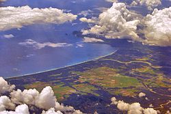
[edit]Aurora is a coastal province covering an area of 3,147.32 square kilometres (1,215.19 sq mi)[38] in east-central Luzon. To the north, it is bordered by the Northern Sierra Madre Natural Park of Isabela, to the west by the central range of the Sierra Madre which contains the Casecnan Protected Landscape and Aurora Memorial National Park, to the south by the Umiray River, and to the east by the Philippine Sea which opens to the Pacific Ocean. The San Ildefonso Peninsula lies in the province's northern portion between the Philippine Sea and the Casiguran Sound.
Topography
[edit]The province covers a portion of the Sierra Madre mountain range. As such, the elevation is generally steep to very steep and only about 14% of the province's total area is flat.[10]
Climate
[edit]Aurora's climate is classified as Tropical rainforest climate.[39] It experiences significant rainfall throughout the year.[39] Because the coastal province faces the Pacific Ocean, it is frequently visited by typhoons.[10][40]
Administrative divisions
[edit]
Aurora is politically subdivided into 8 municipalities, all encompassed by a lone legislative district.
Dilasag and Casiguran form the northern part of the province, while Dinalungan, Dipaculao, Maria Aurora, and Baler (the capital) make up the central portion. The southern half of the province consists of San Luis and Dingalan.
| Municipality [i] | Population | ±% p.a. | Area[38] | Density | Barangay | |||||||
|---|---|---|---|---|---|---|---|---|---|---|---|---|
| (2020)[2] | (2015)[41] | km2 | sq mi | /km2 | /sq mi | |||||||
| 15°45′34″N 121°33′46″E / 15.7595°N 121.5627°E | Baler | † | 18.6% | 43,785 | 39,562 | +1.95% | 92.54 | 35.73 | 470 | 1,200 | 13 | |
| 16°12′15″N 122°02′24″E / 16.2041°N 122.0400°E | Casiguran | 11.3% | 26,564 | 24,313 | +1.70% | 715.43 | 276.23 | 37 | 96 | 24 | ||
| 16°23′23″N 122°12′36″E / 16.3898°N 122.2099°E | Dilasag | 7.3% | 17,102 | 15,835 | +1.48% | 306.25 | 118.24 | 56 | 150 | 11 | ||
| 16°08′30″N 121°57′22″E / 16.1416°N 121.9560°E | Dinalungan | 5.3% | 12,508 | 11,322 | +1.91% | 316.85 | 122.34 | 39 | 100 | 9 | ||
| 15°23′22″N 121°23′34″E / 15.3894°N 121.3927°E | Dingalan | 11.8% | 27,878 | 25,482 | +1.73% | 304.55 | 117.59 | 92 | 240 | 11 | ||
| 15°50′52″N 121°32′12″E / 15.8477°N 121.5367°E | Dipaculao | 14.1% | 33,131 | 29,736 | +2.08% | 361.64 | 139.63 | 92 | 240 | 25 | ||
| 15°47′54″N 121°28′20″E / 15.7982°N 121.4723°E | Maria Aurora | 19.1% | 44,958 | 40,734 | +1.90% | 426.29 | 164.59 | 110 | 280 | 40 | ||
| 15°43′09″N 121°31′04″E / 15.7191°N 121.5178°E | San Luis | 12.7% | 29,824 | 27,352 | +1.66% | 609.85 | 235.46 | 49 | 130 | 18 | ||
| Total | 235,750 | 214,336 | +1.83% | 3,133.40 | 1,209.81 | 75 | 190 | 151 | ||||
| † Provincial capital | Municipality | |||||||||||
| ||||||||||||
Barangays
[edit]The 8 municipalities of the province comprise a total of 151 barangays, with Suclayin in Baler as the most populous in 2010, and Dibalo in San Luis as the least.[42]
Demographics
[edit]
|
|
| |||||||||||||||||||||||||||||||||||||||||||||||||||||||||
| Source: Philippine Statistics Authority[41][42][42] | |||||||||||||||||||||||||||||||||||||||||||||||||||||||||||
The population of Aurora in the 2020 census was 235,750 people,[2] with a density of 75 inhabitants per square kilometre or 190 inhabitants per square mile.
Based on the 2000 census survey, Tagalogs comprised 52.85% (91,745) of the total provincial population of 173,589, and about less than 1/3 of the population were Ilocano at 31.43% (54,557). Other ethnic groups in the province were Kasiguranin at 5.1% (8,853), Bicolano at 4.08% (7,079), Kankanaey at 1.36% (2,355), Bisaya at 0.88% (1,529), Dumagat (Umiray) at 0.6% (1,047), and Cebuano at 0.48% (832).[43]
On the 2010 census survey, Tagalogs numbered 91,219, Ilocanos 67,861, Bicolano 14,250, Kankanaey 4,494, Bisaya 4,786, Umiray Dumagat 1,267, and Cebuano 1,777.[44][45]
There are also pockets of Bugkalots & Negritos, called Dumagats. Most Dumagats are living in the hillsides or mountains. They are believed to have result from a fusion of Austronesian and Melanesian ancestries, and survive from fishing and hunting. There are three kinds of Dumagats in Aurora province, the Umiray Dumagat, Casiguran Dumagat, and the Palanan Dumagat; minor Dumagat groups are called Southern Alta or Alta Kabulowan, Northern Alta or Edimala, and Tagabulós. Bugkalots are the second tribe indigenous to Aurora, most of them live in Dipaculao & Maria Aurora.
Tagalogs, some originating from Palanan and Infanta, Quezon, came in to the area to trade by boat, some Tagalogs settled in Aurora (especially Baler) and married with the Aeta and Bugkalots.[46][47] Kapampangans assimilated to the Tagalog settlers.[4][48][5][6] Among the descendants of Aetas and Bugkalots are from the line of survivors of tromba marina; Bihasas are from Aeta origins and Lumasacs are descendants of Bugkalots. The Spanish brought in Filipino acolytes from other areas of Luzon from 1609 to 1899. During this period, Baler can only be access by sea though the town saw increase migration from other parts of Luzon such as Laguna, Tayabas, and Bicol from the south.
The opening of the Baler-Bongabon Road allowed easier migration of people from Ilocos and Isabela areas from the north. The road also allowed Igorot people and Batangueño Tagalogs to settle in Baler & other places of Aurora. The majority of Igorots settled Dipaculao, Maria Aurora, & Baler.
In 1896, a group of Ilocanos from Aringay, La Union came to settle in San Jose, now called Maria Aurora; in 1906, another group of Ilocanos arrived from La Union and Pangasinan. In the early 1920s, Ilocano settlers from Central Luzon settled a Bugkalot territory Dipaculao, which in turn was derived from the phrase Dipac naulaw or Naulaw ni Dipac, the Ilocano for "Dipac got dizzy", idiomatically "Dipac is/got drunk", Dipac is the name of a Bugkalot chief; another group of Ilocano settlers arrived from La Union, Pangasinan, and other areas of Ilocos Region. The guerrilla movement during the Japanese occupation brought Novo Ecijanos (people from Nueva Ecija) to Baler; Novo Ecijanos include Tagalogs, Ilocanos, and Kapampangans, with quite large number of Pangasinenses.
The Balereños learned trade from the Batangueños and the Novo Ecijanos; where before they used to share what they have, now they would sell coconut to their neighbors.[46][49][50][51] Other ethnic groups who came and stayed in Aurora include Christianized Gaddang and Isinai settlers who settled the surrounding lowlands of Baler Bay.[52] These ethnic groups who lived for several centuries & left cultural influences & legacies made Aurora the melting pot of the Central Luzon, next to Tarlac & Nueva Ecija.
Languages
[edit]This section needs additional citations for verification. (April 2023) |
The Tagalog and Ilocano languages are spoken by their respective ethnic groups. The province primarily speaks a Tagalog dialect that is closely related to Tayabas Tagalog of Quezon with some Ilocano influences.[53] In Baler, for example, the variety is called Tagalog-Baler (Balereño). The Balereño is also known for distinctive expressions like akkaw, used to express surprise, wonder, disgust, and objection; it is also akin to the English term "Wow!" Other regional term expressions spoken in Baler are are(h), used to express a negative feeling of surprise; anin, used to express regret or pity for a situation; and many other words are also spoken similarly to neighboring Quezon, like adyo, meaning to climb, and puropur, which pertain to rain with gusty wind. Ilocano is mostly spoken in northern areas of the province.
The working population is able to converse in English and in Filipino.[54][49][55][56][57][58] Manuel L. Quezon, who was from Baler, was called the Father of the National Language for approving the recommendation of the Institute of National Language for Tagalog as the basis of the national language. Other languages spoken in Aurora are Kapampangan, and Pangasinan (in some areas of the province, most of which is in Baler) and Ga'dang & Isinai in surrounding lowlands of Baler Bay, & other languages native in Aurora are Casiguranin or Kasiguranin, spoken in Casiguran & neighboring areas Dilasag & Dinalungan where Casiguran Dumagat and Paranan Dumagat languages are also spoken, Umiray Dumagat spoken in San Luis and Dingalan, Southern Alta or Alta Kabulowan spoken in Dingalan, Northern Alta or Edimala spoken in Baler, Maria Aurora and San Luis, Tagabulós in Dingalan and San Luis, and Bugkalot spoken in Dipaculao, Maria Aurora, and Baler.[59][60]
Religion
[edit]Catholicism
[edit]
The people of Aurora are heavily Catholics (large majority being Roman Catholic by 87%)[citation needed] as a result of hundreds of years of Spanish colonization.
Others
[edit]Some other Christian believers are also present, which includes Members Church of God International (MCGI), Methodists, Aglipayan Church 2-3%, Baptists, Born Again Christians, Jehovah's Witnesses, Iglesia ni Cristo 4% and Seventh-day Adventist while Muslims are also found which presence is traced to migration by some people from some parts of Mindanao. Muslims, Anitists, animists, and atheists are also present in the province.
Economy
[edit]Corn, rice and other major agricultural crops are grown in Aurora, with a total of 13% of the provincial land area used for agriculture. It also has 8,945 hectares (22,100 acres) of rice plantation that averages 24,000 metric tons (24,000 long tons; 26,000 short tons) every year.[citation needed]
Aurora Pacific Economic Zone
[edit]Casiguran is home to the Aurora Pacific Economic Zone and Freeport Authority or APECO a special economic zone located in this coastal town. Created in 2007 by virtue of Republic Act No. 9490 through the efforts of Sen. Edgardo Angara and his son, Aurora Rep. Sonny Angara, it is expected be a major transshipment hub going to the Pacific region. It aims to boost social, economic and industrial developments in Aurora and nearby provinces by generating jobs for the people, improving the quality of their living conditions, advocating an eco-friendly approach to industrialization and enhancing the potential of the community in productivity.
Culture
[edit]Aurora culture is a mixture of Tagalog and Ilocano, with some Kapampangan, Pangasinense, and other indigenous (mostly Aeta, Bugkalot, and Igorot) cultures within the province. A melting pot of culture, the province has a varied of festivals, traditions, and beliefs that constitute Aurora heritage, along with tangible heritage structures, scenes, and objects.
Gallery
[edit]-
 Bulwagan ng Katarungan
(RTC), Suklayin, Baler -
 Aurora Police Provincial Office, NPC, PNP, Baler
 -
 Aurora Provincial Tourism Office (Suklayin)
 -
-
 Bust of Maria Aurora


Notable people
[edit]
- Sonny Angara, former senator and current secretary of education
- Bellaflor Angara-Castillo, governor from 2004 to 2013
- Edgardo Angara, former senator
- Manuel L. Quezon, first president of the Commonwealth of the Philippines
- Aurora Quezon, former first lady of the Philippines, wife of President Manuel L. Quezon
- Arvin Amatorio, attorney and politician, mayor of Bergenfield, New Jersey
- Reynante Tolentino, governor since 2024
See also
[edit]References
[edit]- ^ "List of Provinces". PSGC Interactive. Makati, Philippines: National Statistical Coordination Board. Archived from the original on 19 April 2016. Retrieved 5 March 2020.
- ^ a b c Census of Population (2020). "Region III (Central Luzon)". Total Population by Province, City, Municipality and Barangay. Philippine Statistics Authority. Retrieved 8 July 2021.
- ^ a b c "The Brief History of Aurora". 19 April 2017. Archived from the original on 2023-11-05. Retrieved 2023-11-05.
- ^ a b c d "Tantingco: The Kapampangan in Us". SunStar. May 2, 2013. Archived from the original on 2024-01-23. Retrieved 2024-01-23.
- ^ a b c d The Language Shift from the Middle and Upper Middle-Class Families in the Kapampangan Speaking Region
- ^ a b c d Pampanga used to be a coast-to-coast mega-province: What happened? on Facebook
- ^ a b c d e f "Aurora, Philippines – History". aurora.ph. Archived from the original on February 8, 2017. Retrieved February 7, 2017.
- ^ a b Baler During Spanish Occupation in Aurora.ph
- ^ a b "History of Quezon Province". Provincial Government of Quezon. Archived from the original on October 1, 2016. Retrieved April 4, 2016.
- ^ a b c d e Lancion, Conrado M. Jr. (1995). "The Provinces; Aurora". Fast Facts about Philippine Provinces. cartography by de Guzman, Rey (The 2000 Millenium ed.). Makati, Metro Manila, Philippines: Tahanan Books. p. 28. ISBN 971-630-037-9. Retrieved 4 December 2015.
- ^ a b Jose, Diocese of San. "Diocese of San Jose, Nueva Ecija – History". dioceseofsanjose.org. Archived from the original on February 8, 2017. Retrieved February 7, 2017.
- ^ "The Archdiocese | Archdiocese of Caceres". caceres-naga.org. Archived from the original on February 8, 2017. Retrieved February 7, 2017.
- ^ GOVPH. "National Historical Commission of the Philippines – "A Filipino society with citizens informed of their history, who love their country and are proud of their cultural heritage."". Nhcp.gov.ph. Archived from the original on May 14, 2013. Retrieved November 5, 2016.
- ^ a b National Historical Commission of the Philippines. "History of Baler". National Historical Commission of the Philippines. Archived from the original on 2019-09-16. Retrieved 2012-03-09.
On December 27, 1935, a big tidal wave or "tromba marina" wiped out the town, then located at Barrio Sabang. An undetermined number of its inhabitants were drowned and only 14 families survived. Among the survivors were the Angaras, Bijasas, Bitongs, Lumasacs, Carrascos and Pobletes. The Muslim raiders attacked Baler, Casiguran and Palanan in 1798...When military district of El Príncipe was created in 1856, Baler became its capital...On June 12, 1902 a civil government was established, moving the district of El Príncipe away from the administrative jurisdiction of Nueva Ecija...and placing it under the jurisdiction of Tayabas Province.
- ^ Who We Are: Nueva Ecija
- ^ "Act No. 417 – An Act Annexing the Districts of Infanta and Principe and the Island of Polillo to the Province of Tayabas". Supreme Court E-Library. Philippine Commission. June 12, 1902. Archived from the original on February 18, 2022. Retrieved February 18, 2022.
- ^ "Act No. 103 – An Act Providing for the Establishment of a Civil Government for the Province of Tayabas". Supreme Court E-Library. Philippine Commission. March 12, 1901. Archived from the original on February 18, 2022. Retrieved February 18, 2022.
- ^ The picture of territorial evolution of Quezon:

- ^ "Pursuant to the authority conferred upon me as Head of the Central Administrative Organization by Order No. 1 in connection with Order No. 3 of the Commander in Chief of the Imperial Japanese Forces in the Philippines and upon the recommendation of the Executive Commission it is hereby ordered that—
- The Province of Batanes is abolished and the comprising the same as well as the territory thereof shall be annexed to the Province Cagayan.
- The municipalities of Baler and Casiguran, Province of Tayabas, and the territories thereof are segregated from said province and shall be annexed to the Province of Nueva Ecija.
- The municipality of Infanta, Province of Tayabas, and the territory thereof are segregated from province and shall be annexed to the Province of Laguna.
- The Province of Marinduque is abolished and municipalities comprising the same as well as territory thereof shall be annexed to the Province of Tayabas.
- The Province of Romblon is abolished and the municipalities comprising the same as well the territory thereof shall be annexed to the of Capiz."
- ^ Provisions of this order only apply for the duration of the Japanese occupation; revoked after the restoration of the Commonwealth in 1945.
- ^ Republic Act No. 14 (7 September 1946), An Act to change the name of the province of Tayabas to Quezon – via Chan Robles Virtual Law Library
- ^ Republic Act No. 14 (September 7, 1946), An Act to Change the Name of the Province of Tayabas to Quezon, retrieved May 1, 2023
- ^ "Republic Act No. 14 – An Act to Change the Name of the Province of Tayabas to Quezon". Supreme Court E-Library. Congress of the Philippines. September 7, 1946. Archived from the original on February 21, 2022. Retrieved February 21, 2022.
- ^ Edgardo Angara. "Baler for All Time". www.aurora.ph.
- ^ What is the Kapampangan Region?
- ^ Republic Act No. 648 (June 14, 1951), An Act Creating the Subprovince of Aurora, Which Shall Comprise the Municipalities of Baler, Casiguran, Dipaculao and Maria Aurora, Province of Quezon, archived from the original on 10 December 2015, retrieved 8 December 2015
- ^ Provincial Government of Aurora. "Aurora, Philippines - History". Aurora.ph. Archived from the original on 2024-04-26. Retrieved 2024-06-17.
- ^ Batas Pambansa Blg. 7 (November 21, 1978), An Act Separating the Sub-province of Aurora from the Province of Quezon and Establishing It as an Independent Province, archived from the original on 3 March 2016, retrieved 8 December 2015
- ^ Kate McGeown (April 16, 2013). "How Apocalypse Now inspired Filipino surfers". BBC News. Archived from the original on October 2, 2019. Retrieved September 26, 2019.
- ^ Jesus T. Peralta. "Geography of Aurora". aurora.ph.
Aurora is the northernmost province of the Southern Tagalog political division (Region IV).
- ^ "Executive Order No. 103: Dividing Region IV into Region IV-A and Region IV-B, Transferring the Province of Aurora to Region III and for Other Purposes". Philippine Statistics Authority – National Statistical Coordination Board. Archived from the original on May 29, 2009. Retrieved November 1, 2014.
- ^ Executive Order No. 103, s. 2002 (May 17, 2002), Dividing Region IV into Region IV-A and Region IV-B, transferring the Province of Aurora to Region III and for other purposes, retrieved May 1, 2023
- ^ Bureau of Local Government Finance Region 3
- ^ "Visit My Philippines: Aurora".
On 23 May 2003,President Gloria Macapagal – Arroyo issued executive order No. 103 that redefined the composition of Central Luzon and Southern Tagalog administrative region. The province of Aurora was included as the seventh province of Central Luzon while the rest of Southern Tagalog was divided into two regions, namely, the CALABARZON and the MIMAROPA regions.
- ^ What is the Kapampangan Region?
- ^ Orejas, Tonette. "EO attaching Aurora to C. Luzon assailed". Philippine Daily Inquirer. aurora.ph.
Sen. Edgardo Angara, Rep. Bellaflor Angara Castillo and Ricky Avanceña, grandson of the late President Manual Quezon, sought the scrapping of the executive order that transferred Aurora to Central Luzon... Angara, who hails from Aurora, called the order a "discretion of the historical, geographical and emotional ties of Aurora to the rest of Southern Tagalog, particularly Quezon province, but also of the memory of our first President, Manuel Quezon. Aurora the birthplace of the late President and his wife Doña Aurora Aragon, was a sub- province of Quezon until 1951... The province located on the eastern tip of Luzon and which faces the Pacific Ocean, is more accessible by land from Nueva Ecija, one of the Central Luzon's Provinces. It is one of the 20 poorest provinces in the country. However, Angara said Aurora residents have "consistently and publicly" identified themselves with Quezon.
- ^ Malig, Jun (April 24, 2024). "Vice gov assumes top post in Aurora". Philippine Daily Inquirer. Archived from the original on April 24, 2024. Retrieved April 25, 2024.
- ^ a b "Province: Aurora (province)". PSGC Interactive. Quezon City, Philippines: Philippine Statistics Authority. Retrieved 8 January 2016.
- ^ a b "Climate: Aurora". Climate-data.org. Archived from the original on 10 December 2015. Retrieved 8 December 2015.
- ^ Iglesias, Iza; Vargas, Anthony; Cueto, Francis Earl A. (17 October 2015). "3 days of heavy rain". The Manila Times. Archived from the original on 10 December 2015. Retrieved 8 December 2015.
- ^ a b Census of Population (2015). "Region III (Central Luzon)". Total Population by Province, City, Municipality and Barangay. Philippine Statistics Authority. Retrieved 20 June 2016.
- ^ a b c Census of Population and Housing (2010). "Region III (Central Luzon)" (PDF). Total Population by Province, City, Municipality and Barangay. National Statistics Office. Retrieved 29 June 2016.
- ^ a b "Aurora: Housing Unit Occupancy Rate Almost 100 Percent; Table 4. Household Population by Ethnicity and Sex: Aurora, 2000". Philippine Statistics Authority. 11 June 2002. Archived from the original on 5 March 2012. Retrieved 26 July 2016.
- ^ "2010 Census of Population and Housing Report No. 2A: Table 11. Household Population by Ethnicity and Sex: 2010" (PDF). Archived from the original (PDF) on 2022-09-26. Retrieved 2024-01-22.
- ^ https://web.archive.org/web/20240611112939/https://www.psa.gov.ph/system/files/main-publication/Aurora_0.pdf. Archived from the original (PDF) on 2024-06-11.
{{cite web}}: Missing or empty|title=(help) - ^ a b Mesina, Ilovita. "Baler And Its People, The Aurorans". Aurora.ph. Archived from the original on 11 October 2023. Retrieved 21 February 2018.
- ^ Barrows, David P. (1910). "The Ilongot or Ibilao of Luzon". Popular Science Monthly. Vol. 77, no. 1–6. pp. 521–537.
These people (Ilongot) scattered rancherias toward Baler and sustain trading relations with the Tagalog of that town, but are hostile with the Ilongot of Nueva Vizcaya jurisdiction... It may be that these Ilongot communicate with the Tagalog town of Kasiguran.
- ^ What is the Kapampangan Region?
- ^ a b "Baler and Other Sceneries of Aurora". 2 June 2019. Archived from the original on 2024-01-31. Retrieved 2024-01-31.
- ^ "Lowland Cultural Group of the Tagalogs". Archived from the original on 2022-09-26. Retrieved 2024-01-22.
- ^ Municipality of Dipaculao
- ^ "Encyclopedia.com: Ilongot". Archived from the original on 2024-04-25. Retrieved 2024-04-25.
- ^ Discovering Aurora Archived January 31, 2024, at the Wayback Machine in phinder.ph
- ^ Aurora: Who We Are Archived 2023-04-19 at the Wayback Machine in DILG website
- ^ "Aurora Province Travel Guide". Proudly Filipino. 18 May 2024.
- ^ Selaznog, Olag (2013). Ak'kaw Poppo: Talaan ng Salitang Baler (1st ed.). Makati City: Baler Aurora Ngayon Angkan at Kasaysayan (Banak Inc.).
- ^ "Batang Baler Ako Website". Archived from the original on 2023-04-21. Retrieved 2023-04-21.
- ^ "OoCities: Batang Baler". Archived from the original on 2023-03-14. Retrieved 2023-03-14.
- ^ "Discover the Philippines: Aurora Province". 7 December 2020. Archived from the original on 2023-12-29. Retrieved 2023-12-29.
- ^ Komisyon ng Wikang Filipino: Wika at Kultura - Tagabulós
- ^ "Poverty incidence (PI):". Philippine Statistics Authority. Retrieved December 28, 2020.
- ^ "Estimation of Local Poverty in the Philippines" (PDF). Philippine Statistics Authority. 29 November 2005.
- ^ "2009 Official Poverty Statistics of the Philippines" (PDF). Philippine Statistics Authority. 8 February 2011.
- ^ "Annual Per Capita Poverty Threshold, Poverty Incidence and Magnitude of Poor Population, by Region and Province: 1991, 2006, 2009, 2012 and 2015". Philippine Statistics Authority. 27 August 2016.
- ^ "Annual Per Capita Poverty Threshold, Poverty Incidence and Magnitude of Poor Population, by Region and Province: 1991, 2006, 2009, 2012 and 2015". Philippine Statistics Authority. 27 August 2016.
- ^ "Annual Per Capita Poverty Threshold, Poverty Incidence and Magnitude of Poor Population, by Region and Province: 1991, 2006, 2009, 2012 and 2015". Philippine Statistics Authority. 27 August 2016.
- ^ "Updated Annual Per Capita Poverty Threshold, Poverty Incidence and Magnitude of Poor Population with Measures of Precision, by Region and Province: 2015 and 2018". Philippine Statistics Authority. 4 June 2020.
- ^ "2021 Full Year Official Poverty Statistics of the Philippines" (PDF). Philippine Statistics Authority. 15 August 2022. Retrieved 28 April 2024.

External links
[edit] Media related to Aurora at Wikimedia Commons
 Geographic data related to Aurora (province) at OpenStreetMap
Places adjacent to Aurora (province) | |
|---|---|
| Municipalities | |
|---|---|
| Barangays | |

| International | |
|---|---|
| National | |
| Other | |
Aurora (province)
View on GrokipediaAurora is a coastal province in the Central Luzon region of the Philippines, encompassing a land area of 3,030 square kilometers and a population of 235,750 as of the 2020 census.[1][2] With Baler as its capital and provincial center, the province consists of eight municipalities and is bordered by Isabela to the north, Quirino and Nueva Vizcaya to the northwest, Nueva Ecija to the west, Bulacan to the southwest, and Quezon to the south.[3] Established on August 13, 1979, through Batas Pambansa Blg. 7 signed by President Ferdinand Marcos, Aurora was carved out from the northern and eastern portions of Quezon province and named in honor of Aurora Quezon, wife of former President Manuel L. Quezon.[4][5] The province features rugged terrain dominated by the Sierra Madre mountain range, which runs parallel to its eastern Pacific coastline, fostering diverse ecosystems including dense forests, rivers, and beaches that support agriculture, forestry, and emerging tourism centered on surfing and ecotourism.[6][7] Economically, Aurora relies primarily on farming of crops like rice, coconut, and banana, alongside fishing and limited mining, though its remote location and exposure to typhoons from the Pacific pose ongoing challenges to development and infrastructure.[7] Historically linked to early Spanish missions established by Franciscans in the 17th century and later events such as the 1898 Siege of Baler involving Spanish holdouts, the province maintains a cultural heritage tied to indigenous Dumagat and Ilongot groups amid its transition to provincial status.[4]
History
Pre-colonial and Spanish colonial periods
Prior to Spanish arrival, the territory comprising modern Aurora province was inhabited by indigenous groups including the Dumagat (also known as Agta), Aeta, Ilongot (Bugkalot), and early Tagalog-speaking communities. These populations engaged in hunting, gathering, fishing, and rudimentary farming, with settlements scattered along the Pacific coast and Sierra Madre foothills. The Dumagat, a Negrito subgroup, maintained a semi-nomadic lifestyle focused on foraging and harmony with the forested environment.[8][9] Spanish exploration of the area began in the late 16th century, with Juan de Salcedo reportedly sighting the coast in 1573. Franciscan missionaries initiated evangelization efforts, with Father Esteban Ortiz reaching the eastern Sierra Madre in 1578–1579 and Father Blas Palomino founding missions in Baler, Casiguran, and Palanan in 1609. Fray Francisco de San Antonio served as the first parish priest of Baler on October 24, 1611, constructing an initial nipa and wood church. Administration of the missions alternated between Franciscans and Augustinian Recollects, with the latter taking control in 1658 before Franciscan reclamation in 1703.[8][10][11] The region, initially affiliated with Pampanga and later Tayabas (now Quezon), faced repeated challenges from Moro pirate raids, including a major attack on Baler, Casiguran, and Palanan in 1798. A devastating tsunami on December 27, 1735, destroyed the original Baler settlement near the coast, prompting relocation inland to present-day Zabali; Franciscan Father Jose Urbina de Esparragosa later fortified defenses with watchtowers in 1847 and initiated a 3-mile irrigation canal. By 1856, the area was organized as the Distrito del Príncipe, with Baler as capital, encompassing towns like Dipaculao, San Jose de Casecnan, and Casiguran. A stone fortress church, featuring 1.5-meter-thick walls, was constructed in Baler during the 19th century. Christian population reached 3,551 by 1896, amid growing revolutionary sentiment that culminated in the Katipunan chapter formation and the Siege of Baler from 1898 to 1899, marking the effective end of Spanish control.[8][11][10]American colonial era
In the aftermath of the Siege of Baler, which concluded with the surrender of the last Spanish garrison on June 2, 1899, American forces advanced into the region amid the escalating Philippine-American War. Filipino revolutionaries in the area, initially aligned against Spanish rule, shifted resistance toward U.S. troops, leading to sporadic clashes in the rugged Sierra Madre terrain. On December 28, 1899, U.S. Colonel Luther W. Hare led a relief party that rescued a small group of Americans besieged in Baler, establishing an early foothold for American military operations in the district.[12] This event underscored the challenges of pacification in the remote, forested localities comprising the future Aurora territory, where guerrilla tactics prolonged hostilities into 1901.[13] Under initial military governance, the District of El Príncipe—encompassing Baler, Casiguran, Polillo, and adjacent areas—was administered as a frontier zone dependent on Laguna province. The Philippine Commission, seeking to consolidate control, enacted Act No. 223 on June 12, 1902, annexing El Príncipe to Tayabas province, thereby integrating its municipalities into a larger administrative framework extending from the Pacific coast to central Luzon.[14] Baler, as the district's key settlement, transitioned to civil government shortly thereafter, with local elites appointed as municipal presidents under U.S. supervision; Dr. Lucino Almeida served as an early provincial presidente, facilitating cooperation between American authorities and Filipino landowners.[15] This reorganization emphasized cadastral surveys and land titling to promote export agriculture, particularly abaca and copra, though the region's isolation limited large-scale infrastructure until the 1920s. American colonial policies introduced public education and sanitary reforms, with Thomasite teachers establishing primary schools in Baler by 1903, raising literacy rates from near-zero to approximately 20% in rural Tayabas subdistricts by 1918. Road construction, including rudimentary coastal trails, connected Baler to Infanta by 1910, aiding troop movements and trade, while health campaigns targeted malaria and tuberculosis prevalent in the humid lowlands. Economic activity centered on subsistence farming and fishing, with minimal foreign investment due to the area's typhoon-prone geography and ethnic Dumagat communities' resistance to resettlement schemes. By the 1930s, under the expanded Tayabas framework, the district contributed modestly to provincial rice and coconut outputs, reflecting gradual integration into the colonial economy without major industrialization.[16]Japanese occupation and World War II
In early 1942, after the surrender of U.S. and Filipino forces on Corregidor on May 6, Imperial Japanese Army units consolidated control over Luzon, extending occupation to the eastern coastal region of Tayabas Province (encompassing present-day Aurora). Japanese troops entered Baler, the principal municipality, and repurposed the Baler Elementary School as their primary garrison, commanded by a captain.[17] This foothold facilitated patrols and resource extraction, though Japanese presence remained lighter in rural eastern areas compared to urban centers like Manila, due to challenging terrain and limited strategic value.[18] Local resistance emerged promptly, with civilians and remnants of the United States Army Forces in the Far East (USAFFE) forming guerrilla bands that disrupted Japanese operations through ambushes, sabotage, and intelligence relays to Allied commands. In Tayabas Province, these units operated semi-autonomously, leveraging knowledge of Sierra Madre mountain passes for hit-and-run tactics against supply convoys and outposts.[18] [19] Such activities aligned with the nationwide guerrilla effort, which numbered over 260,000 recognized fighters by war's end, though specific engagements in Baler vicinity involved small-scale skirmishes rather than major battles. Japanese countermeasures included reprisals and forced labor, exacerbating food shortages and civilian hardships amid broader wartime deprivations.[20] The occupation concluded in 1945 amid the U.S. Sixth Army's Luzon campaign, initiated with landings at Lingayen Gulf on January 9. By late February and March, advancing divisions, augmented by Filipino guerrillas, pushed into eastern Luzon, overrunning isolated garrisons like Baler's with limited fighting as Japanese units retreated northward or inland to fortified positions. Formal Japanese capitulation in the Philippines followed on September 2, 1945, aboard USS Missouri, ending three years of control in the region.[21]Post-independence to provincial establishment
Following the restoration of civil governance after World War II and Philippine independence in 1946, the northern municipalities of what is now Aurora province—Baler, Casiguran, Dipaculao, and Maria Aurora—remained integrated within Quezon Province (formerly Tayabas), administered from the distant provincial capital of Lucena. This arrangement exacerbated post-war recovery difficulties, as the rugged Sierra Madre mountains and lack of adequate roads isolated these areas from southern Quezon, limiting access to government services, markets, and infrastructure development. The postwar period saw Baler and Casiguran particularly languishing, with minimal economic progress amid subsistence agriculture and fishing, compounded by the absence of direct administrative focus from Lucena.[22] To address these administrative and developmental gaps, Republic Act No. 648 was enacted on June 14, 1951, under President Elpidio Quirino, establishing the Sub-Province of Aurora comprising the municipalities of Baler, Casiguran, Dipaculao, and Maria Aurora. The sub-province was named in honor of Aurora Aragon Quezon, wife of the late President Manuel L. Quezon, at the urging of Baler Mayor Pedro V. Guerrero and Doña Aurora herself, who advocated for localized governance to foster growth in the underdeveloped region. This status granted semi-autonomous administration, including a separate lieutenant governor and funding allocations, while still subordinating it to Quezon for certain fiscal and legislative matters; subsequent expansions incorporated additional municipalities such as Dilasag, Dinalongan, Dingalan, and San Luis. Despite these measures, the sub-province's dependency on Quezon persisted, with ongoing complaints from residents about delayed services and inadequate investment due to geographical separation exceeding 200 kilometers by road.[23][4] By the late 1970s, demands for full provincial autonomy intensified among local leaders and residents, citing persistent isolation and the need for direct control over resources to accelerate infrastructure like roads and ports. On November 21, 1978, Batas Pambansa Blg. 7 was approved, separating the sub-province from Quezon and constituting it as the independent Province of Aurora, with Baler as the capital; the law took effect following a favorable plebiscite on February 19, 1979, officially establishing the province on that date under President Ferdinand Marcos. This separation transferred all sub-provincial assets, liabilities, and personnel to the new entity, enabling tailored policies for local fisheries, agriculture, and tourism potential while integrating Aurora into Central Luzon for regional coordination. The creation fulfilled long-standing local aspirations for self-determination, though it occurred amid Marcos' broader martial law-era provincial reorganizations.[24][25]Marcos administration and early development
Batas Pambansa Blg. 7, enacted on November 21, 1978, under President Ferdinand Marcos, separated the sub-province of Aurora from Quezon and established it as an independent province, subject to ratification by plebiscite.[25][26] The plebiscite occurred on May 20, 1979, approving the separation and constituting Aurora as the 73rd province of the Philippines, with Baler designated as the capital.[26] The province officially commenced operations on August 13, 1979.[27] The province initially encompassed five municipalities—Baler, Casiguran, Dipaculao, Maria Aurora, and San Luis—which had formed the sub-province since 1951. Governance during this period operated under the martial law framework, with local officials appointed by Marcos to oversee administration. Jose Etcubañez served as the first appointed governor, focusing on establishing provincial offices and basic administrative structures in Baler.[28] Early development emphasized rural self-sufficiency, leveraging the province's agricultural base of coconut, rice, and fishing industries, though specific infrastructure initiatives remained limited amid national priorities. The Marcos regime integrated Aurora into broader New Society programs for rural electrification and feeder roads, but the province's remote location and recent formation constrained rapid progress, with economic activity centered on subsistence farming and minimal industrial output. No major national-scale projects, such as those seen in urban centers, were documented specifically for Aurora in this era, reflecting its status as a newly carved, underdeveloped territory.[29]Post-Marcos era and contemporary history
Following the EDSA Revolution in February 1986, which ousted Ferdinand Marcos and restored democratic elections, Aurora province experienced a shift in governance amid national political realignment. Eunice Pablo Guerrero-Cucueco, previously involved in local administration, served as governor from 1988 to 1991, marking the initial post-dictatorship leadership before succession disputes arose.[30] Edgardo L. Ong then assumed the governorship in 1991 through succession and held office until 2001, followed by his wife Ramoncita P. Ong from 2001 to 2004; these terms reflected the emergence of family-based political networks common in Philippine provinces.[31] Bellaflor Angara-Castillo, from the influential Angara family, governed from 2004 to 2013, prioritizing infrastructure improvements and tourism promotion to diversify the economy beyond agriculture and fishing.[30] Gerardo A. Noveras succeeded her, serving from 2013 to 2022 and overseeing responses to natural hazards while advancing eco-tourism initiatives. Reynante A. Tolentino has been governor since June 2022, focusing on post-pandemic recovery and economic zone expansion.[32] Local politics has been characterized by competition between the Ong and Angara clans, with the latter maintaining broader national influence through figures like former Senate President Edgardo Angara.[31] The province faced significant natural disasters in this era, underscoring its vulnerability to seismic and tropical activity. On August 2, 1986, a 7.3-magnitude earthquake centered in Casiguran killed 270 people and injured 261, damaging structures across northern Aurora and prompting reconstruction efforts.[33] In late 2004, four successive typhoons triggered landslides and flash floods, killing hundreds and displacing thousands in rural areas, which highlighted deficiencies in disaster preparedness and led to calls for improved early warning systems.[34] Economic development accelerated with the creation of the Aurora Pacific Economic Zone and Freeport Authority (APECO) in 2007 via Republic Act No. 9498, aimed at attracting investments in agro-industry, logistics, and tourism through tax incentives and infrastructure like ports and roads.[35] This complemented organic growth in tourism, driven by Baler's surfing waves and natural sites, transitioning the province from subsistence farming to service-oriented revenue; visitor numbers surged to 3,280,741 in 2024, including over 1.1 million in the first quarter of 2025 alone, positioning Aurora as a key domestic destination.[36][37] Recent APECO projects include renovated tourism facilities in Casiguran and planned logistics hubs, targeting sustained growth amid annual Holy Week influxes exceeding 400,000 visitors.[38][39] Despite these advances, challenges persist, including reliance on seasonal tourism and exposure to typhoons, with poverty incidence remaining above the national average as of recent Philippine Statistics Authority data.[3]Geography
Location and topography
Aurora Province occupies the mid-eastern coast of Luzon island in the Philippines, forming part of the Central Luzon region (Region III). It lies along the western edge of the Philippine Sea, with its eastern boundary defined by Pacific coastal waters. The province's political boundaries include Isabela to the north, Quirino and Nueva Ecija to the west, and Quezon to the south.[40][41] The topography of Aurora is dominated by the eastern flanks of the Sierra Madre mountain range, resulting in predominantly rugged and steep terrain. Elevations range from sea level along narrow coastal strips to over 1,800 meters in the interior highlands, with approximately 14% of the land classified as flat or gently sloping. Flatlands are limited to unevenly distributed coastal lowlands and alluvial plains in river valleys draining eastward to the sea.[42][43][44] Major landforms include high, forested mountains interspersed with short, steep rivers and limited agricultural plains near the coast. The Sierra Madre's influence creates a landscape of deep valleys and escarpments, with minimal intermediate plateaus, contributing to the province's isolation and vulnerability to erosion and landslides.[43][41]Climate and natural hazards
Aurora province lies within the tropical rainforest climate zone (Köppen Af), featuring consistently high humidity, temperatures, and abundant precipitation year-round. Average annual temperatures range from 22°C to 33°C, with a mean of approximately 24.1°C in Baler, the provincial capital.[45] [46] The dry season spans November to April, with relatively lower rainfall, while the wet season from May to October brings increased monsoon influences, though rainfall distribution shows peaks in January, February, April, October, and November, averaging 273.9 mm monthly province-wide.[42] Annual precipitation totals around 2,493 mm in Baler, with extremes reaching 1,200 mm in peak months due to the influence of the Sierra Madre mountains trapping moisture.[45] [41] The province's eastern exposure to the Pacific Ocean renders it highly susceptible to tropical cyclones, which account for the majority of natural disasters. An average of 20 typhoons enter the Philippine Area of Responsibility annually, with several making landfall in or near Aurora, causing destructive winds, storm surges, flooding, and landslides.[47] Typhoon Ompong (international name Mangkhut) in September 2018 struck directly, with winds up to 215 km/h, triggering widespread flooding and landslides that damaged infrastructure and agriculture across the province.[48] The rugged topography of the Sierra Madre range exacerbates landslide risks during heavy rains, as seen in recurrent events in municipalities like Baler and Casiguran.[48] [49] Seismic activity poses additional threats, given Aurora's position along the Philippine Fault and proximity to subduction zones. The province experiences moderate to strong earthquakes periodically, such as the 1990 Luzon earthquake (magnitude 7.7) that affected Central Luzon, including Aurora, causing ground rupture and secondary hazards like liquefaction in coastal areas.[48] Flooding from river overflows, particularly along the Dibut Creek and Agsan River systems, compounds risks during typhoons, with vulnerability assessments highlighting limited early warning systems and information access as aggravating factors.[50] No active volcanoes are present within the province, but distant eruptions can contribute to ashfall or lahar threats.[48]Administrative divisions and barangays
Aurora Province is administratively subdivided into eight municipalities, comprising a total of 151 barangays, the basic local government units responsible for grassroots administration, including community policing, health services, and infrastructure maintenance at the village level.[6] Baler serves as the provincial capital and hosts key government offices.[51] The municipalities vary in size and population density, with Maria Aurora containing the highest number of barangays.| Municipality | Number of Barangays |
|---|---|
| Baler | 13[52] |
| Casiguran | 24[53] |
| Dilasag | 11[54] |
| Dinalungan | 9[55] |
| Dingalan | 11[56] |
| Dipaculao | 25[57] |
| Maria Aurora | 40[58] |
| San Luis | 18[59] |
Demographics
Population and trends
As of the 2020 Census of Population and Housing conducted by the Philippine Statistics Authority, Aurora Province had a total population of 235,750 persons, representing 1.90% of Central Luzon's regional population and 0.38% of the national total.[2] This marked an increase of 21,414 individuals from the 2015 census figure of 214,336, reflecting an annualized growth rate of 2.02% over the intervening period.[2] The 2024 Census, with results certified as of July 1, updated the provincial population to 240,824, indicating continued modest expansion amid national demographic shifts.[60] Aurora's population density remains low at 77.79 persons per square kilometer, based on its 3,030 km² land area, underscoring its predominantly rural character with limited urbanization.[1] Historical trends show consistent growth driven primarily by natural increase rather than significant in-migration, as the province's remote location and exposure to natural hazards like typhoons constrain large-scale settlement.[61] Between 2010 and 2015, the average annual growth rate was approximately 1.21%, lower than the national average, with projections suggesting sustained but decelerating increases aligned with broader Philippine fertility declines.[50]| Census Year | Population | Annual Growth Rate (from prior census) |
|---|---|---|
| 2015 | 214,336 | - |
| 2020 | 235,750 | 2.02% |
| 2024 | 240,824 | N/A (preliminary post-2020) |