
Community hub
Recent from talks
Contribute something
Nothing was collected or created yet.
Geography of Kuwait
View on Wikipedia
Kuwait is a country in West Asia, bordering the Persian Gulf, between Iraq and Saudi Arabia. Kuwait is located at the far northwestern corner of the Persian Gulf. Kuwait is 17,820 square kilometres in size. At its most distant points, it is about 200 km (120 mi) north to south, and 170 km (110 mi) east to west. Kuwait has 10 islands. Kuwait's area consists mostly of desert.
Key Information

Boundaries and geographic features
[edit]
As previously mentioned, Kuwait borders the Persian Gulf with 195 km (121 mi) of coast.[1] Within its territory are ten islands, two of which, Bubiyan (the largest) and Warbah, are strategically important.[1]
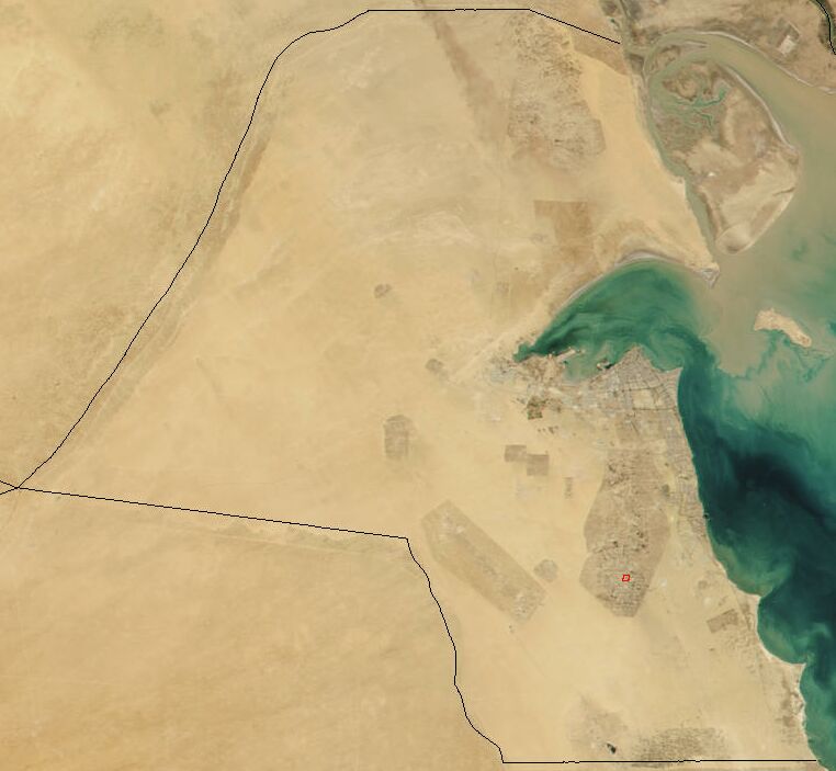
Kuwait's most prominent geographic feature is Kuwait Bay (Jun al Kuwayt), which indents the shoreline for about forty kilometers, providing natural protection for the port of Kuwait, and accounts for nearly one third of the country's shoreline.[1]
To the north and northwest, there is the historically contested border between Kuwait and Iraq.[1] Although the Iraqi government, which had first asserted a claim to rule Kuwait in 1938, recognized the borders with Kuwait in 1963 (based on agreements made earlier in the century), it continued to press Kuwait for control over Bubiyan and Warbah islands through the 1960s and 1970s.[1]
To the south and southwest, Kuwait shares a 250-km border with Saudi Arabia.[1] The boundary between Kuwait and Saudi Arabia was set by the Treaty of Al Uqayr in 1922, which also established the Saudi–Kuwaiti neutral zone of 5,700 square kilometers between the two nations.[1] In 1966, Kuwait and Saudi Arabia agreed to divide the neutral zone; the partitioning agreement making each country responsible for administration in its portion was signed in December 1969.[1] The resources in the area, now known as the Divided Zone, are not affected by the agreement.[1] The oil from onshore and offshore fields continues to be shared equally between the two countries.[1]
In August 1990, Iraq invaded Kuwait and, shortly thereafter, formally incorporated the entire country into Iraq.[1] Under United Nations (UN) Security Council Resolution 687, after the restoration of Kuwaiti sovereignty in 1991, a UN commission undertook formal demarcation of the borders on the basis of those agreed to in 1963.[1] The boundary was demarcated in 1992.[1] Iraq initially refused to accept the commission's findings[1] but ultimately accepted them in November 1994.[2][3]
Climate
[edit]
Kuwait has an arid climate.[1] Rainfall in the nation varies from 75 to 150 millimeters (2.95 to 5.91 in) a year.[1] Actual rainfall has ranged from 25 millimeters (0.98 in) a year to as much as 325 millimeters (12.8 in).[1] In summer, average daily high temperatures range from 42 to 46 °C (108 to 115 °F);[1] the highest ever temperature recorded in Kuwait was 54 °C (129 °F) at Mitribah on 21 July 2016 which is the highest recorded temperature in Asia and also the third highest in the world.[4][5] The summers are relentlessly long, punctuated mainly by dramatic dust storms in June and July when northwesterly winds cover the cities in sand.[1] In late summer, which is more humid, there are occasional sharp, brief thunderstorms.[1]
By November summer is over, and colder winter weather sets in, dropping temperatures to as low as 3 °C (37 °F) at night; daytime temperatures are in the upper 20s °C (upper 70s to low 80s °F).[1] Frost rarely occurs; rain is more common and falls mostly in the spring.[1]
Kuwait's winter is colder than in other Persian Gulf countries, such as Bahrain, Qatar or United Arab Emirates. Kuwait experiences colder weather because it is situated farther north, and because of cold winds blowing from upper Iraq and Iran.[6]
| Climate data for Kuwait City | |||||||||||||
|---|---|---|---|---|---|---|---|---|---|---|---|---|---|
| Month | Jan | Feb | Mar | Apr | May | Jun | Jul | Aug | Sep | Oct | Nov | Dec | Year |
| Record high °C (°F) | 29.8 (85.6) |
35.8 (96.4) |
41.2 (106.2) |
44.2 (111.6) |
49.0 (120.2) |
49.8 (121.6) |
52.1 (125.8) |
50.7 (123.3) |
47.7 (117.9) |
43.7 (110.7) |
37.9 (100.2) |
30.5 (86.9) |
52.1 (125.8) |
| Mean daily maximum °C (°F) | 19.5 (67.1) |
21.8 (71.2) |
26.9 (80.4) |
33.9 (93.0) |
40.9 (105.6) |
45.5 (113.9) |
46.7 (116.1) |
46.9 (116.4) |
43.7 (110.7) |
36.6 (97.9) |
27.8 (82.0) |
21.9 (71.4) |
34.3 (93.7) |
| Mean daily minimum °C (°F) | 8.5 (47.3) |
10.0 (50.0) |
14.0 (57.2) |
19.5 (67.1) |
25.4 (77.7) |
28.9 (84.0) |
30.7 (87.3) |
29.5 (85.1) |
26.2 (79.2) |
21.5 (70.7) |
14.5 (58.1) |
9.9 (49.8) |
19.9 (67.8) |
| Record low °C (°F) | −4.0 (24.8) |
−1.6 (29.1) |
−0.1 (31.8) |
6.9 (44.4) |
14.7 (58.5) |
20.4 (68.7) |
22.4 (72.3) |
21.7 (71.1) |
16.0 (60.8) |
9.4 (48.9) |
2.0 (35.6) |
−1.5 (29.3) |
−4.0 (24.8) |
| Average rainfall mm (inches) | 30.2 (1.19) |
10.5 (0.41) |
18.2 (0.72) |
11.5 (0.45) |
0.4 (0.02) |
0.0 (0.0) |
0.0 (0.0) |
0.0 (0.0) |
0.0 (0.0) |
1.4 (0.06) |
18.5 (0.73) |
25.5 (1.00) |
116.2 (4.57) |
| Average rainy days (≥ 0.1 mm) | 5 | 3 | 3 | 1 | 0 | 0 | 0 | 0 | 0 | 1 | 3 | 3 | 19 |
| Mean monthly sunshine hours | 198.1 | 222.5 | 217.6 | 229.3 | 272.5 | 304.5 | 307.1 | 301.6 | 285.1 | 252.2 | 216.5 | 193.5 | 3,000.5 |
| Mean daily sunshine hours | 7.1 | 7.7 | 7.5 | 7.9 | 9.4 | 10.5 | 10.6 | 10.8 | 10.2 | 9.0 | 7.7 | 6.9 | 8.8 |
| Percentage possible sunshine | 68 | 69 | 63 | 62 | 69 | 77 | 76 | 78 | 77 | 79 | 72 | 67 | 72 |
| Source: World Meteorological Organization (temperature and rainfall 1994–2008);[7] NOAA (sunshine and records, 1961–1990);[8] Wundergound (2012 records)[9] | |||||||||||||
Nature reserves
[edit]At present, there are five protected areas in Kuwait recognized by the IUCN. In response to Kuwait becoming the 169th signatory of the Ramsar Convention, Bubiyan Island's Mubarak al-Kabeer reserve was designated as the country's first Wetland of International Importance.[10] The 50,948 ha reserve consists of small lagoons and shallow salt marshes and is important as a stop-over for migrating birds on two migration routes.[10] The reserve is home to the world's largest breeding colony of crab-plover.[10]
Biodiversity
[edit]Currently, 444 species of birds have been recorded in Kuwait, 18 species of which breed in the country.[11] Due to its location at the head of the Persian Gulf near the mouth of the Tigris–Euphrates river, Kuwait is situated at the crossroads of many major bird migration routes and between two and three million birds pass each year.[12] Kuwait's marine and littoral ecosystems contain the bulk of the country's biodiversity heritage.[12] The marshes in northern Kuwait and Jahra have become increasingly important as a refuge for passage migrants.[12]
Twenty eight species of mammal are found in Kuwait; animals such as gerboa, desert rabbits and hedgehogs are common in the desert.[12] Among the endangered mammalian species are the red fox and wild cat.[12] Forty reptile species have been recorded although none are endemic to Kuwait.[12]
Kuwait, Oman and Yemen are the only locations where the endangered smoothtooth blacktip shark is confirmed as occurring.[13]
Kuwaiti islands are important breeding areas for four species of tern and the socotra cormorant.[12] Kubbar Island has been recognised an Important Bird Area (IBA) by BirdLife International because it supports a breeding colony of white-cheeked terns.[14]
Geology and aquifers
[edit]The land was formed in a recent geologic era. In the south, limestone rises in a long, north-oriented dome that lies beneath the surface.[1] It is within and below this formation that the principal oil fields, Kuwait's most important natural resource, are located.[1] In the west and north, layers of sand, gravel, silt, and clay overlie the limestone to a depth of more than 210 meters.[1] The upper portions of these beds are part of a mass of sediment deposited by a great wadi whose most recent channel was the Wadi al Batin, the broad shallow valley forming the western boundary of the country.[1]
On the western side of the Al Rawdatayn geological formation, a freshwater aquifer was discovered in 1960 and became Kuwait's principal water source.[1] The supply is insufficient to support extensive irrigation, but it is tapped to supplement the distilled water supply that fills most of the country's needs.[1] The only other exploited aquifer lies in the permeable zone in the top of the limestone of the Ash Shuaybah field south and east of the city of Kuwait.[1] Unlike water from the Al Rawdatayn aquifer, water from the Ash Shuaybah aquifer is brackish. Millions of liters a day of this water are pumped for commercial and household purposes.[1]
Water and marshes
[edit].svg)
Kuwait is part of the Tigris–Euphrates river system basin.[15][16][17][18][19][20] Several Tigris–Euphrates confluences form parts of the Kuwait–Iraq border.[21] Bubiyan Island is part of the Shatt al-Arab delta.[22] Kuwait is partially part of the Mesopotamian Marshes.[23][24][25] Kuwait does not currently have any permanent rivers within its territory. However, Kuwait does have several wadis, the most notable of which is Wadi al-Batin which forms the border between Kuwait and Iraq.[26] Kuwait also has several river-like marine channels around Bubiyan Island, most notably Khawr Abd Allah which is now an estuary, but once was the point where the Shatt al-Arab emptied into the Persian Gulf. Khawr Abd Allah is located in southern Iraq and northern Kuwait, the Iraq-Kuwait border divides the lower portion of the estuary, but adjacent to the port of Umm Qasr the estuary becomes wholly Iraqi. It forms the northeast coastline of Bubiyan Island and the north coastline of Warbah Island.[27]
Kuwait relies on water desalination as a primary source of fresh water for drinking and domestic purposes.[28][29] There are currently more than six desalination plants.[29] Kuwait was the first country in the world to use desalination to supply water for large-scale domestic use. The history of desalination in Kuwait dates back to 1951 when the first distillation plant was commissioned.[28]
Kuwait's fresh water resources are limited to groundwater, desalinated seawater, and treated wastewater effluents.[28] There are three major municipal wastewater treatment plants.[28] Most water demand is currently satisfied through seawater desalination plants.[28][29] Sewage disposal is handled by a national sewage network that covers 98% of facilities in the country.[30]
Human geography
[edit]The bulk of the Kuwaiti population lives in the coastal capital of the city of Kuwait. Smaller populations inhabit the nearby city of Al Jahrah, smaller desert and coastal towns, and, prior to the Persian Gulf War, some of the several nearby gulf islands, notably Faylakah.[1]
Area boundaries
[edit]- Area
-
- Total: 17,818 km²
- Land: 17,818 km²
- Water: 0 km²
- Area—comparative
- Slightly smaller than Fiji
- Land boundaries
-
- Total: 475 km
- Border countries: Iraq 254 km, Saudi Arabia 221 km
- Coastline
- 499 km
- Maritime claims
- Exclusive Economic Zone
- 11,026 km2 (4,257 mi2)
- Territorial sea: 12 nmi (22.2 km; 13.8 mi)
- Elevation extremes
-
- Lowest point: Persian Gulf 0 m
- Highest prominence: Mutla Ridge 142 m
- Highest point: unnamed site without prominence in the Jahra Governorate at 29°6′2″N 46°38′27″E / 29.10056°N 46.64083°E 291 m
Resources and land use
[edit]- Natural resources
- Petroleum, fish, shrimp, natural gas
- Land use
-
- Arable land: 0.6%
- Permanent crops: 0.3%
- Permanent pasture: 7.6%
- Forest: 0.4%
- Other: 91.1% (2011)
- Irrigated land
- 86 km² (2007)
- Total renewable water resources
- 0.02 km3 (2011)
- Freshwater withdrawal (domestic/industrial/agricultural)
-
- Total: 0.91 km3/yr (47%/2%/51%)
- Per capita: 441.2 m3/yr (2005)
Environmental concerns
[edit]
- Natural hazards
- Sudden cloudbursts are common from October to April – they bring heavy rain which can damage roads and houses; sandstorms and dust storms occur throughout the year, but are most common between March and August
- Environment—current issues
- Limited natural fresh water resources; some of world's largest and most sophisticated desalination facilities provide much of the water; air and water pollution; desertification
- Environment—international agreements
References
[edit]- ^ a b c d e f g h i j k l m n o p q r s t u v w x y z aa ab ac ad ae
 This article incorporates text from this source, which is in the public domain: Crystal, Jill (1994). Metz, Helen Chapin (ed.). Persian Gulf states: country studies (3rd ed.). Washington, D.C.: Federal Research Division, Library of Congress. pp. 47–50. ISBN 0-8444-0793-3. OCLC 29548413.
- ^ "Iraq". The World Factbook. Central Intelligence Agency. 2000. Archived from the original on 11 December 2000. Retrieved 1 September 2021.
- ^ Crossette, Barbara (11 November 1994). "Iraqis to accept Kuwait's borders". The New York Times. p. A1.
- ^ "WMO verifies 3rd and 4th hottest temperature recorded on Earth". public.wmo.int/en. World Meteorological Organization (WMO). 18 June 2019. Archived from the original on 18 December 2023. Retrieved 5 July 2019.
- ^ "Upgraded HWRF and GFDL Hurricane Models Excelled During Hurricane Arthur". Weather Underground. USA: Dr. Jeff Masters. 11 July 2014. Archived from the original on 17 January 2013. Retrieved 13 July 2014.
- ^ "Surveying and Establishment of a Comprehensive Database for the Marine Environment of Kuwait eMISK" (PDF).
- ^ "World Weather Information Service – Kuwait City". World Meteorological Organization. Retrieved 19 February 2014.
- ^ "Kuwait International Airport Climate Normals 1961–1990". National Oceanic and Atmospheric Administration. Archived from the original on 9 December 2020. Retrieved 15 January 2015.
- ^ "Dr. Jeff Masters' article published January 2013". National Oceanic and Atmospheric Administration. Archived from the original on 17 January 2013. Retrieved 20 July 2015.
- ^ a b c Ramsar (7 September 2015). "Kuwait becomes Ramsar state". BirdGuides. Archived from the original on 19 February 2016. Retrieved 7 September 2015.
- ^ Lepage, Denis. "Checklist of birds of Kuwait". Bird Checklists of the World. Avibase.
- ^ a b c d e f g "National Biodiversity Strategy for the State of Kuwait". 7 September 2015. p. 12. Archived from the original on 19 February 2016.
- ^ Edmonds, N.J.; Al-Zaidan, A.S.; Al-Sabah, A.A.; Le Quesne, W.J.F.; Devlin, M.J.; Davison, P.I.; Lyons, B.P. (February 2021). "Kuwait's marine biodiversity: Qualitative assessment of indicator habitats and species". Marine Pollution Bulletin. 163 111915. Bibcode:2021MarPB.16311915E. doi:10.1016/j.marpolbul.2020.111915. PMID 33360724.
- ^ "Kubbar Island". BirdLife Data Zone. BirdLife International. 2021. Retrieved 24 February 2021.
- ^ Abdelmohsen, Karem; Sultan, Mohamed; Save, Himanshu; Abotalib, Abotalib Z.; Yan, Eugene; Zahran, Khaled H. (2022). "Buffering the impacts of extreme climate variability in the highly engineered Tigris Euphrates river system". Scientific Reports. 12 (1): 4178. Bibcode:2022NatSR..12.4178A. doi:10.1038/s41598-022-07891-0. PMC 8907168. PMID 35264678. S2CID 247361048.
- ^ Zentner, Matthew (2012). Design and impact of water treaties: Managing climate change. Springer. p. 144. ISBN 978-3-642-23743-0.
The Tigris-Euphrates-Shatt al Arab is shared between Iraq, Iran, Syria, Kuwait and Turkey.
- ^ Rubec, Clayton (2009). "The Key Biodiversity Areas Project in Iraq: Objectives and scope 2004–2008": 40.
{{cite journal}}: Cite journal requires|journal=(help) - ^ "Lower Tigris & Euphrates". feow.org. 2013. Archived from the original on 17 November 2015.
- ^ "Lower Tigris & Euphrates". feow.org.
- ^ Bozkurt, Deniz; Omer Lutfi Sen (2012). "Hydrological response of past and future climate changes in the Euphrates-Tigris Basin" (PDF). p. 1.
The Euphrates-Tigris Basin, covering areas in five countries (Turkey, Iraq, Syria, Iran and Kuwait), is a major water resource of the Middle East.
- ^ Caldwel, Dan (2011). Vortex of Conflict: U.S. Policy Toward Afghanistan, Pakistan, and Iraq. Stanford University Press. p. 60. ISBN 978-0-8047-7749-0.
- ^ Reinink-Smith, Linda; Carter, Robert (2022). "Late Holocene development of Bubiyan Island, Kuwait". Quaternary Research. 109: 16–38. Bibcode:2022QuRes.109...16R. doi:10.1017/qua.2022.3. S2CID 248250022.
- ^ Hurst, Christon J. (13 May 2019). The Structure and Function of Aquatic Microbial Communities. Springer. ISBN 978-3-030-16775-2.
- ^ Irzoqy, Israa Mahmooed Mohammed; Ibrahim, Lamia Flaieh; Al-Tufaily, Hodoud Mohamed Abboud (2022). "Analysis of the environmental reality of the marshes and its sustainable development". IOP Conference Series: Earth and Environmental Science. 1002 (1): 7–15. Bibcode:2022E&ES.1002a2010I. doi:10.1088/1755-1315/1002/1/012010. S2CID 248237509.
- ^ Wilson, Anthony (15 November 2017). Swamp: Nature and Culture. Reaktion Books. ISBN 978-1-78023-891-3.
- ^ Wadi Al-Bāṭin.
- ^ "'Abd Allah Khawr". Encyclopædia Britannica. Vol. I: A-Ak – Bayes (15th ed.). Chicago, Illinois: Encyclopædia Britannica, Inc. 2010. pp. 16. ISBN 978-1-59339-837-8.
- ^ a b c d e F. Hamoda, Mohamed (September 2001). "Desalination and water resource management in Kuwait". Desalination. 138 (1–3): 165. doi:10.1016/S0011-9164(01)00259-4.
- ^ a b c "Irrigation in the near east region in figures". Food and Agriculture Organization. Archived from the original on 11 October 2016. Retrieved 12 March 2016.
- ^ "Regulations of Wastewater Treatment and Reuse in Kuwait". Beatona. Archived from the original on 19 February 2016. Retrieved 12 March 2016.
Attribution:
- This article incorporates public domain material from The World Factbook (2025 ed.). CIA.
Geography of Kuwait
View on GrokipediaKuwait is a small sovereign state in the Middle East, located at the head of the Persian Gulf between Iraq and Saudi Arabia, encompassing 17,818 square kilometers of flat to slightly undulating desert plain with minimal elevation variation, rising to a maximum of 306 meters.[1] The country's terrain lacks permanent rivers or lakes, features sparse vegetation, and supports limited agriculture on just 0.6% arable land, while its 499-kilometer coastline along the Gulf provides access to marine resources including fish and shrimp.[1] Kuwait's climate is hyper-arid desert, marked by intensely hot summers exceeding 45°C, short cool winters with occasional frost, and annual precipitation under 150 millimeters, contributing to severe water scarcity addressed through extensive desalination infrastructure.[1] Petroleum and associated natural gas reserves, concentrated in fields like Burgan, dominate its geography as the principal natural resources, underpinning economic development amid otherwise resource-poor sandy expanses.[1]
Location and Boundaries
Political and Land Borders
Kuwait's land borders total 475 kilometers, shared exclusively with Iraq to the north and west for 254 kilometers and Saudi Arabia to the south for 221 kilometers. These boundaries run from the tripoint with Saudi Arabia and Iraq in the southwest, extending northward and eastward to the Persian Gulf coast. The borders are largely desert terrain, marked by fences, ditches, and monitoring infrastructure, particularly along the Iraqi frontier fortified after the 1990 invasion.[1] The Iraq-Kuwait land border originated from Anglo-Ottoman conventions in the early 20th century, with formal recognition in the 1963 Agreed Minutes between Iraq's prime minister and Kuwait's heir apparent, affirming Kuwait's sovereignty and territorial integrity. Iraq disputed this under Saddam Hussein, claiming Kuwait as its 19th province and invading on August 2, 1990, which prompted the Gulf War. Post-liberation, United Nations Security Council Resolution 687 established the United Nations Iraq-Kuwait Boundary Demarcation Commission (UNIKBDC), which demarcated the border on May 20, 1993, based on historical evidence favoring the 1932 and 1963 alignments, granting Iraq access to the Gulf via the Nawab Sirri channel but confirming Kuwaiti control over key oil fields like Rumaila. This demarcation, ratified internationally, resolved land disputes and has remained stable, with joint border committees managing crossings like Safwan, upgraded in 2019 for trade.[2] The Saudi-Kuwait border stems from the 1922 Treaty of Al-Uqair, which introduced a neutral zone to defer disputes amid undefined Ottoman-era lines, covering about 5,770 square kilometers jointly administered until partition. On July 7, 1965, the two nations signed an agreement dividing the onshore neutral zone equally, effective January 18, 1969, establishing the current boundary while preserving shared offshore rights until a 2019 memorandum resolved remaining issues, resuming joint oil production in 2020. This arrangement, managed through bilateral commissions, emphasizes resource cooperation over rigid enforcement, with no active territorial claims.[3][4]Maritime Boundaries and Exclusive Economic Zone
Kuwait exercises sovereignty over its territorial sea, extending 12 nautical miles from baselines along its 499-kilometer coastline on the Persian Gulf, including a straight baseline closing Kuwait Bay as defined by geographical coordinates submitted to the United Nations.[5][6] A contiguous zone adjoins the territorial sea up to 24 nautical miles, proclaimed under Decree No. 317 of 2014, enabling control over customs, fiscal, immigration, and sanitary matters.[7] Beyond the territorial sea lies the exclusive economic zone (EEZ), where Kuwait claims sovereign rights for exploring and exploiting natural resources, extending up to 200 nautical miles or to agreed boundaries with adjacent and opposite states, in line with customary international law principles despite Kuwait's non-ratification of the UNCLOS.[7] The EEZ spans approximately 11,786 square kilometers, constrained by the narrow Gulf geometry and proximity to neighbors.[8] The maritime boundary with Saudi Arabia follows a line established by an exchange of notes on July 4, 1965, partitioning the offshore extension of the former neutral zone along approximately 48 degrees east longitude, allocating equal shares of potential hydrocarbon resources.[9] This was supplemented by a 2000 agreement delineating submerged areas adjacent to the partitioned zone, including coordinates for the boundary extension into the Gulf, ratified and effective from January 25, 2003, resolving ambiguities over fields like Hasbah and Safaniya without third-party arbitration.[10][5] Delimitation with Iraq remains incomplete, with the land boundary fixed by UN demarcation in 1993-1994, but the maritime extension into the Khor Abdullah waterway and beyond marker 162 unresolved despite bilateral efforts.[11] A 2012 memorandum of understanding regulates navigation safety in the shared channel, ratified by Iraq in 2013, but Iraq's 2023 Supreme Court ruling deemed it unconstitutional, prompting renewed talks and international calls, including from the GCC and US in September 2023, for full demarcation to prevent encroachments like alleged Iraqi oil drilling in Kuwaiti waters.[12][13] Kuwait maintains its claims protect access to deep-water ports and resources, while Iraq seeks equitable Gulf access limited by its short coastline.[14] No bilateral treaty delimits the boundary with Iran, resulting in overlapping EEZ assertions, particularly east of Failaka Island where Kuwait's claims extend beyond the provisional median line toward the Iranian coast.[15] The dispute centers on the Dorra (Iranian: Arash) gas field, discovered in 1966, with Kuwait and Saudi Arabia granting concessions overlapping Iranian claims; Iran seized a South Pars extension rig in 2013 and rejects Kuwaiti exploration rights, citing undefined 1960s boundaries, while bilateral talks since the 1970s have failed amid hydrocarbon stakes estimated at trillions of cubic feet.[16][17] Kuwait upholds its 2014 maritime zones law, which incorporates equitable principles for undelimited areas, but Iranian positions, rooted in historical Gulf dominance assertions, complicate resolution without arbitration.[18]Physical Geography
Topography and Landforms
Kuwait's topography consists primarily of a flat to gently undulating desert plain, with elevations rising gradually from sea level at the Persian Gulf coast in the east to a maximum of 306 meters above sea level at Mutla Ridge in the northwest.[19][1] The country's surface is characterized by Quaternary sands and gravels, forming featureless expanses interrupted by low-relief structures.[20] Prominent landforms include scattered ridges and hills, often aligned parallel to the coast or structural features. The Jal al-Zor ridge, overlooking Kuwait Bay, reaches 145 meters in height and consists of consolidated aeolian and marine sediments.[19] Southward, the Ahmadi Ridge extends parallel to the shoreline at up to 129 meters, while Mutla Ridge represents the highest elevation, formed by tectonic uplift and erosion-resistant layers.[19] These ridges, typically 5 to 15 meters high in coastal areas, originated as dunes during sea level regressions and have been stabilized over time.[21] Interior regions feature aeolian deposits, including approximately 2,304 sand dunes distributed across seven dune fields, with the longest barchanoid chain measuring 2,400 meters.[22] Gravel plains dominate much of the northwest, alongside sabkhas—evaporite flats formed in closed depressions where groundwater evaporation precipitates salts—and occasional dry wadis channeling infrequent runoff.[20] These elements reflect ongoing wind-driven processes shaping the arid landscape, with dunes migrating under prevailing northerly winds.[23]Coastline and Islands
Kuwait's coastline borders the Persian Gulf for 499 kilometers, featuring predominantly shallow waters averaging less than 20 meters in depth nearshore, with sandy and muddy substrates interspersed by sabkhas (salt flats) and limited rocky sections in the south.[1] The terrain transitions abruptly from desert interior to coastal lowlands, where tidal ranges reach up to 3 meters, driving sediment dynamics that result in both erosion and accretion; rates of shoreline change have been documented at 1-5 meters per year in vulnerable areas due to wave action and longshore currents.[24] A defining geomorphic element is Kuwait Bay, an embayment extending roughly 40 kilometers inland from the northern coast, which creates a sheltered inlet conducive to sedimentation and supporting mangroves in its fringes, while enabling the development of Kuwait City's primary port facilities. The archipelago comprises nine islands, primarily low-lying and fringed by tidal flats, totaling over 1,000 square kilometers in combined area but mostly uninhabited except for Failaka. Bubiyan Island, the largest at 863 square kilometers, occupies the northwestern Gulf position adjoining Iraqi waters and features extensive mudflats, salt marshes, and channels forming a deltaic landscape; its flat elevation rarely exceeds 5 meters above sea level, rendering it prone to inundation and valuable as a wetland for avian migration, though development plans have been proposed for port and industrial uses.[25] Warbah Island, connected to Bubiyan via causeways and spanning about 375 square kilometers, shares similar marshy characteristics and strategic border proximity, with minimal human activity limited to military outposts.[19] Failaka Island, situated 20 kilometers offshore from Kuwait City and measuring approximately 10 kilometers by 4 kilometers, preserves stratified archaeological layers from Bronze Age Dilmun trading posts (circa 2000 BCE), Hellenistic settlements under Alexander the Great's influence (fourth century BCE), and later Islamic periods, evidenced by excavations revealing temples, forts, and pottery; it sustains a small permanent population engaged in fishing and tourism, with ferry access facilitating visits to its beaches and ruins.[26] The remaining islands—Miskan, Auhah, Umm al-Maradim, Umm an-Namil, Kubbar, and Qaru—are diminutive, ranging from 0.1 to 5 square kilometers, often barren or vegetated sparingly with halophytes; Kubbar and Qaru support seasonal fishing camps and coral-adjacent reefs attracting divers, while Umm al-Maradim features a navigational lighthouse amid its arid expanse.[19] These peripheral islands contribute to Kuwait's exclusive economic zone claims, influencing maritime boundary delimitations with neighbors amid ongoing hydrocarbon explorations.[27]Recent Land Reclamation and Development Projects
Kuwait has pursued land reclamation primarily to expand usable territory for ports, refineries, and industrial zones, addressing limitations posed by its arid terrain and coastal sabkhas. A notable project involved the reclamation of 1,320 hectares in a sabkha area 30 kilometers north of the Saudi border for the Al-Zour Refinery complex, completed in 2016. This effort utilized 65 million cubic meters of sand dredged and placed to create stable ground, alongside soil improvement techniques such as vibro-compaction and stone columns, enabling construction of a refinery with 615,000 barrels per day capacity, a dedicated service port, and phase one of an LNG import facility.[28] The Mubarak Al-Kabeer Port project on Boubyan Island represents an ongoing initiative with significant reclamation components, aimed at enhancing Kuwait's maritime trade hub status by improving access to the Red Sea via deeper navigation channels. Initial phases included dredging muddy flats, quay wall construction, and land reclamation for a service harbor and access infrastructure, with the total allocated port area amended in 2024 to approximately 11,616 hectares encompassing navigation zones, services, and logistics facilities. Field work resumed in March 2025 under a Kuwait-China agreement, targeting full operational status by the end of 2026, including 24 berths developed in three phases over 30 years.[29][30][31] These projects are integrated into broader Kuwait Vision 2035 plans for northern islands like Boubyan and Failaka, where marshy and low-lying terrains necessitate reclamation for tourism, residential, and protectorate developments, though execution has focused more on planning and access causeways than large-scale filling to date. Environmental considerations include sedimentation management and hydrodynamic modeling to mitigate impacts on Khor Abdullah waters.[32][33]Geology
Geological Structure and Formation
Kuwait occupies the northeastern margin of the Arabian Plate, a stable cratonic block that originated as part of the Proterozoic Gondwana Supercontinent and has since drifted northward at 2–3 cm per year following separation from the African Plate approximately 25–30 million years ago. The plate's ongoing collision with the Eurasian Plate generates NE-SW oriented compressive stress, manifesting in transpressional tectonics that influence regional structures through fault reactivation and salt tectonics involving the Infracambrian Hormuz evaporites. This tectonic regime has shaped Kuwait's geology amid a history of episodic subsidence punctuated by uplift events, such as the Hercynian Orogeny in the Late Devonian to Late Carboniferous and Alpine phases from the Late Cretaceous onward, fostering the accumulation of Phanerozoic sediments up to 7–8 km thick overlying Precambrian crystalline basement.[34][34][35] The primary structural features include the north-south trending Kuwait Arch, a broad anticlinal uplift extending over 500 km as part of the Khurais-Burgan system with up to 100 m of structural relief, which hosts major hydrocarbon accumulations and reflects reactivation of Paleozoic basement trends like the Najd Fault System. Flanking this are the Dibdibba Trough to the west, a NNW-SSE depression with maximum sedimentary thicknesses exceeding 28,000 feet (about 8.5 km), and the Summan Platform further west, bounded by north-south faults. These elements arose from inherited Precambrian lineaments, Jurassic extensional stresses, Cretaceous transtension, and Miocene-present transpression linked to Zagros Fold-Thrust Belt development, with additional complexity from halokinesis and en-echelon faulting along features like Wadi Al Batin. Crustal thickness beneath Kuwait averages 42.6 km, supporting a stable platform setting despite proximity to active margins.[34][34][34] Subsurface stratigraphy comprises a >10 km succession of shallow-marine to sabkha deposits from the Upper Permian onward, dominated by carbonates, evaporites, and clastics deposited during repeated transgressions and regressions driven by eustatic sea-level fluctuations and intra-plate subsidence. Key units include the Permian-Triassic Khuff Formation (up to 1,800 ft of dolomitic limestones in subtidal-lagoonal settings), Triassic Jilh and Sudair Formations (anhydrite-shale sequences in hypersaline environments), Jurassic carbonates like Marrat and Dhruma (shallow shelf deposits), Cretaceous clastics such as the Burgan Formation (deltaic sands), and Cenozoic carbonates of the Radhuma and Dammam Formations (shallow marine to evaporitic). Unconformities mark erosional hiatuses from tectonic uplifts, while lateral thickness variations stem from gentle folding and faulting, culminating in the flat-lying Quaternary surface sands that mask underlying structural complexity.[36][36][36]Soils and Aquifers
Kuwait's soils are predominantly sandy in texture, with low organic matter and scarce plant nutrients, limiting their suitability for agriculture.[37] These soils exhibit aridisol dominance, covering 70.8% of surveyed areas, alongside entisols at 29.2%, reflecting the arid depositional environment of loose sands and gravels.[38] Mineralogically, they include mixed, carbonatic, gypsic, and hypergypsic classes, with textures ranging from sandy to sandy-skeletal and coarse-loamy.[39] Four primary soil groups prevail: desert soils, desert-regosol intergrades, lithosols, and alluvial soils, often featuring gypsum accumulations.[40] [41] Degradation processes such as wind and water erosion, salinization, waterlogging, vegetative loss, and compaction threaten soil integrity, driven by aridity, overgrazing, and vehicular traffic.[42] Salinization, in particular, serves as an indicator of broader land degradation, intensified by poor soil quality and Gulf War oil contamination residues.[43] The loose sandy landscapes heighten vulnerability to wind erosion, contributing to desertification risks.[44] Aquifers in Kuwait primarily comprise the Quaternary Kuwait Group, consisting of greenish gravelly sands and conglomerates, and the underlying Eocene Dammam Formation of limestone, which together form the main groundwater sources.[45] [46] The Kuwait Group aquifer hydraulically connects to the Dammam under natural conditions, with regional flow from inland recharge areas, though Tertiary sediments overall supply usable brackish to fresh water.[47] [48] Overexploitation for agriculture and urban use has caused water table declines up to 20 meters in southern areas, elevating salinity through evaporation and seawater intrusion along coastal zones.[49] [50] Groundwater quality varies, with many samples showing high total dissolved solids unsuitable for potable use without treatment, compounded by mismanagement and climate-driven aridity.[51] [52] Stable isotope analyses indicate evaporative influences on aquifer recharge, further degrading freshness.[53]Climate
Climatic Zones and Patterns
Kuwait features a uniform hot desert climate classified as BWh under the Köppen-Geiger system, characterized by extreme aridity, high temperatures, and minimal precipitation across its territory.[54][55] This classification reflects the subtropical desert conditions prevalent in the Arabian Peninsula's northeastern region, with no significant subdivision into distinct climatic zones due to the country's compact size of approximately 17,818 square kilometers and predominantly flat topography.[56] The hyper-arid nature results in annual rainfall averaging 110-120 mm, primarily occurring during winter and spring months from November to April, often in sporadic, convective showers influenced by synoptic systems from the north.[57] Spatial distribution of precipitation shows slight variations, with coastal areas receiving marginally higher amounts due to proximity to the Persian Gulf, though overall patterns remain consistent nationwide, exhibiting high interannual variability and recurrent droughts.[58] Wind patterns dominate seasonal dynamics, featuring persistent northwesterly shamal winds that enhance evaporation and dust transport year-round, peaking in summer and contributing to the arid conditions.[59] Summers experience long durations of sweltering heat with low humidity inland, while winters are cooler and drier, with occasional overcast skies preceding rare rainfall events driven by southeasterly flows.[60] These patterns underscore Kuwait's vulnerability to climatic extremes, with minimal topographic influence allowing uniform exposure to regional atmospheric circulations.[61]
Temperature, Precipitation, and Extremes
Kuwait's climate features extreme diurnal and seasonal temperature variations typical of a hot desert environment, with summer daytime highs frequently surpassing 45°C and winter nighttime lows occasionally falling below freezing. Annual average temperatures hover around 25°C, but monthly means range from approximately 14°C in January to 38.5°C in August in Kuwait City.[60][62] Precipitation is scant, averaging about 115 mm annually over the long term (1901–2024), primarily occurring as sporadic winter showers influenced by Mediterranean depressions, while summers remain arid with negligible rainfall.[63] Seasonal temperature patterns show summer (May–September) dominated by intense solar heating and shamal winds, yielding average daily highs of 43–47°C and lows of 28–31°C, often accompanied by low humidity except during brief dew periods. Winters (December–February) bring milder conditions with average highs of 20–22°C and lows of 9–10°C, though cold fronts can introduce frost. Transitional seasons exhibit rapid shifts, with spring winds exacerbating dust storms and heat buildup. These patterns derive from Kuwait's subtropical high-pressure dominance and flat topography, which minimize moderating influences like elevation or vegetation.[64][60]| Month | Avg. Max Temp (°C) | Avg. Min Temp (°C) | Avg. Precipitation (mm) | Rain Days |
|---|---|---|---|---|
| Jan | 19.5 | 8.5 | 30.2 | 5.0 |
| Feb | 21.8 | 10.0 | 10.5 | 3.0 |
| Mar | 26.9 | 14.0 | 18.2 | 3.0 |
| Apr | 33.9 | 19.5 | 11.5 | 3.0 |
| May | 40.9 | 25.4 | 0.4 | 1.0 |
| Jun | 45.5 | 28.9 | 0.0 | 0.0 |
| Jul | 46.7 | 30.7 | 0.0 | 0.0 |
| Aug | 46.9 | 29.5 | 0.0 | 0.0 |
| Sep | 43.7 | 26.2 | 0.0 | 0.0 |
| Oct | 36.6 | 21.5 | 1.4 | 1.0 |
| Nov | 27.8 | 14.5 | 18.5 | 3.0 |
| Dec | 21.9 | 9.9 | 25.5 | 3.0 |
Observed and Projected Climate Variations
Kuwait has exhibited a warming trend in air temperatures over recent decades, with mean annual temperatures increasing due to a combination of global atmospheric changes and local factors such as urbanization and heat island effects. Analysis of data from 1971 to 2020 indicates positive linear trends in annual and seasonal temperatures, particularly during summer months, based on ERA5 reanalysis datasets.[66][67] This rise aligns with broader regional patterns in the Arabian Peninsula, where observed temperature increases exceed 1°C since the mid-20th century, supported by instrumental records from Kuwait International Airport. Precipitation patterns show high interannual variability, with annual totals fluctuating between lows of 34.4 mm and highs exceeding 200 mm in recorded years, but no statistically significant long-term trend emerges owing to dominant natural forcings like El Niño-Southern Oscillation influences.[68][57] Extreme heat events have intensified, with days above 50°C becoming more frequent; for instance, such temperatures occurred on only 18 days prior to recent decades but have risen amid the overall warming.[69] Projections from CMIP6 ensemble models, as synthesized in Kuwait's national reports and peer-reviewed assessments, forecast further temperature increases across all seasons, with the most pronounced warming in winter under shared socioeconomic pathways (SSPs). By mid-century (2040-2059 relative to 2000-2009 baselines), average temperatures are expected to rise by 1.8°C under SSP2-4.5 (moderate emissions) to 2.57°C under SSP5-8.5 (high emissions), accelerating the frequency and intensity of heatwaves.[70][71] Precipitation projections indicate potential declines in mean annual totals, exacerbating aridity, though model spread remains wide due to Kuwait's position in a subtropical high-pressure zone prone to subsidence; some scenarios predict 10-20% reductions by end-century under high-emission paths.[72] These changes are anticipated to heighten risks to health and water resources, with extreme heat linked to increased cardiovascular hospitalizations—projected to rise by up to 2% by late century under moderate scenarios.[73] Official Kuwaiti adaptation planning, drawing on IPCC frameworks, emphasizes these trends while noting uncertainties in precipitation from internal climate variability.[74]Hydrology and Water Resources
Surface Water Bodies and Wetlands
Kuwait possesses no permanent rivers or natural lakes, with surface water limited to ephemeral streams that form in wadis during rare flash floods triggered by intense rainfall events.[75][76] These wadis, such as Wadi al-Batin along the northern border with Iraq, channel sporadic runoff from shallow desert depressions, but flows are short-lived and highly variable, often leading to rapid inundation and sediment transport.[77] Annual precipitation averages under 120 mm, concentrated in winter storms, resulting in flash floods that can peak at velocities exceeding 5 m/s and cause localized erosion or deposition, though total surface runoff contributes negligibly to water supply.[78][79] Wetlands in Kuwait are scarce and predominantly coastal, comprising sabkhas—evaporative salt flats that intermittently hold hypersaline water—and shallow salt marshes influenced by tidal fluctuations in the Arabian Gulf.[80] Sabkhas, distributed along the elongated coastal depressions from Al-Jailaiaha to Al-Khiran, form through groundwater seepage, marine flooding, and aeolian deposition, covering areas up to several square kilometers but rarely exceeding 1-2 meters in depth during wet periods.[81] Inland examples are minimal, with the Jahra Pools Reserve representing a key semi-natural wetland complex of shallow pools, marshes, and tamarisk thickets sustained partly by treated wastewater effluent amid surrounding sabkha flats.[82] Further north, Boubyan Island features tidal creeks and salt marshes within a network of habitats supporting migratory avifauna, though these are vulnerable to urban expansion and oil pollution legacies.[83] Overall, such features occupy less than 1% of Kuwait's 17,818 km² land area, functioning primarily as seasonal evaporative basins rather than persistent aquatic ecosystems.[84]Groundwater Resources
Kuwait's groundwater resources are confined to two primary aquifers: the unconfined Kuwait Group aquifer, consisting of sand and gravel layers, and the underlying confined Dammam Formation aquifer, composed of karstic limestone and dolomite.[85][45] The Kuwait Group aquifer holds fresher water with salinity typically ranging from 205 to 975 mg/L, though some wells exceed 1,300 mg/L, making it suitable for limited agricultural and domestic blending uses.[45] In contrast, the Dammam aquifer, the main source of brackish groundwater, exhibits salinity from 2,500 mg/L in southwestern areas to over 20,000 mg/L in the northeast, with dominant water types including Na₂SO₄, CaSO₄, and NaCl.[86][87] Its thickness varies from 120 m in the southwest to 280 m in northern regions like Sabriya.[87] Recharge to these aquifers is minimal due to Kuwait's arid climate and low precipitation, with the Dammam Formation primarily replenished from outcrops in southern Iraq and Saudi Arabia rather than local infiltration.[86][88] Extraction occurs mainly from fields such as Sulaibiya, Shagaya, and Umm Gudair, where brackish water supports irrigation after desalination blending.[89] However, intensive pumping since the mid-20th century has caused significant depletion, with groundwater levels dropping up to 200 m by 2000 in southern areas, forming cones of depression that exacerbate seawater intrusion and salinity increases from 4,000 to 20,000 mg/L in overexploited zones.[90][85] Water quality assessments, such as water quality indices (WQI), indicate that only about 18% of samples from areas like Al-Shagaya meet standards for drinking or irrigation without treatment, due to elevated total dissolved solids (TDS) averaging 2,403–5,672 mg/L and chemical dominance of sulfates.[86] The Dammam aquifer's karstic nature contributes to variable transmissivity and productivity, but overexploitation has lowered potentiometric heads, promoting vertical leakage from the Kuwait Group and horizontal flow disruptions.[91][92] Kuwait's per capita renewable groundwater has declined sharply, from 17.3 m³/year in 1977 to 4.8 m³/year in 2018, underscoring unsustainable extraction rates that prioritize short-term agricultural needs over long-term aquifer sustainability.[85] Management efforts, including IAEA-supported studies on aquifer interactions, emphasize controlled pumping and artificial recharge to mitigate further degradation, though desalination remains the dominant water supply source.[93]Desalination and Water Management Infrastructure
Kuwait's water supply infrastructure is dominated by seawater desalination, which accounts for over 90 percent of the country's potable water production due to the absence of renewable surface water sources and the depletion of non-renewable groundwater aquifers.[89] The Ministry of Electricity, Water, and Renewable Energy (MEW) manages the integrated production, transmission, and distribution systems, primarily through cogeneration plants that simultaneously generate electricity and desalinated water using thermal processes powered by natural gas and oil.[94] This reliance stems from high per capita consumption—exceeding 500 liters per day in households—driven by subsidized pricing and arid conditions, with total daily demand approaching 3.5 million cubic meters as of 2023.[95] Major desalination facilities include the Shuwaikh, Doha, Az-Zour, and Subiya plants, utilizing predominantly multi-stage flash (MSF) distillation supplemented by seawater reverse osmosis (SWRO). Installed capacity reached approximately 683.7 million imperial gallons per day (MIGPD), or about 3.1 million cubic meters per day, by 2020, with projections for expansion to 762.9 MIGPD by 2026 to meet growing demand from population increases and industrial needs.[96] The Subiya plant, operational since 2008, incorporates hybrid MSF-SWRO technology with a capacity of 455,000 cubic meters per day, representing about 15 percent of national output and exemplifying the shift toward more energy-efficient reverse osmosis to reduce thermal energy dependence.[97][98] The Doha West facility contributes 502,000 cubic meters per day via MSF, while expansions at Az-Zour, including Phase 1 completed in recent years, add significant hybrid capacity integrated with 2,000 megawatts of power generation.[97][99] Water management infrastructure features a network of reservoirs, pipelines, and pumping stations for storage and distribution, with strategic reserves holding up to 20 days of supply to buffer against operational disruptions. Treated wastewater reuse, managed separately but complementing desalination, supports non-potable demands like irrigation, with ongoing projects such as the expansion of the largest facility to one million cubic meters per day capacity.[100] Challenges include high energy intensity—desalination consumes about 15 percent of Kuwait's electricity—and environmental impacts from brine discharge, prompting pilots in renewable integration, such as solar-powered reverse osmosis at smaller scales.[100] Future developments, including the Khairan plant's first phase adding 1.8 gigawatts of power alongside desalination under public-private partnerships, aim to enhance reliability amid projected demand growth to 2050.[101]| Major Desalination Plant | Technology | Capacity (cubic meters/day) | Operational Notes |
|---|---|---|---|
| Subiya | Hybrid MSF-SWRO | 455,000 | Largest hybrid facility; 37.5% SWRO share[97][98] |
| Doha West | MSF | 502,000 | Key coastal plant for central distribution[97] |
| Doha East | MSF/SWRO | 191,000 | Supports urban supply[97] |
| Az-Zour (combined phases) | Hybrid | ~545,000 (Phase expansions) | Integrated with power; ongoing upgrades[99] |
Biodiversity
Plant Life and Vegetation
Kuwait's vegetation is predominantly xerophytic and halophytic, adapted to hyper-arid conditions with annual precipitation averaging less than 120 mm and high soil salinity. The flora comprises 374 native and adapted vascular plant species across 55 families, with annuals constituting 68.4% (256 species), herbaceous perennials 22.5% (84 species), and shrubs or undershrubs 9.1% (34 species); only one native tree species exists.[102][103] Dwarf shrubs dominate the perennial cover, which is sparse at under 20% across most landscapes, concentrated in wadis, depressions, and coastal zones.[104] Major vegetation communities include Rhanterium epapposum shrublands on gravelly northern plains, Haloxylon salicornicum associations in sandy interiors, and Cyperus conglomeratus-dominated grassy patches in runnels. Halophytic formations prevail in sabkhas and coastal flats, featuring Hammada salicornica, Seidlitzia rosmarinus, and Nitraria retusa, which tolerate high salinity and periodic flooding.[104][105] Perennial grasses and sedges, such as Cynodon dactylon, cover about 68% of surveyed vegetated areas, while shrubs occupy 27%.[106] Vegetation patterns reflect geomorphological and edaphic factors, with four primary types: interior sand dune shrublands, northern gravel plains, southern saline depressions, and coastal mangal fringes featuring Avicennia marina in limited intertidal zones.[107][108] Annual ephemerals, including Plantago ovata and Schismus barbatus, surge after erratic winter rains, enhancing short-term biodiversity but reverting to dormancy in summer. Overgrazing and urbanization have reduced cover by up to 50% in unprotected areas since the 1970s, though reserves like Shamal Sinaitiya show denser regrowth.[107][109] Native species support soil stabilization and wildlife forage, underscoring their ecological role in this resource-scarce ecosystem.[110]Animal Species and Habitats
Kuwait's fauna comprises approximately 32 mammal species, over 300 bird species, around 48 reptile species, and limited amphibian presence, primarily adapted to arid desert environments, coastal zones, and offshore islands. Terrestrial mammals such as the lesser jerboa (Jaculus jaculus), sand fox (Vulpes rueppelli), and desert hedgehog (Hemiechinus aethiopicus) inhabit sandy and gravelly deserts, where they exploit nocturnal foraging to evade diurnal heat. Predators like the striped hyena (Hyaena hyaena) and golden jackal (Canis aureus) range across semi-desert steppes, preying on rodents and scavenging, though populations have declined due to habitat fragmentation.[111][112] Bird diversity is dominated by migratory species utilizing Kuwait's position along the East Asian-Australasian Flyway and Afro-Palearctic routes, with habitats spanning hyper-arid deserts, irrigated farmlands, and coastal wetlands. Resident breeders include the desert lark (Ammomanes deserti) in gravel plains and the white-eared bulbul (Pycnonotus leucotis) in scrublands, while wetlands like those on Bubiyan Island support waders such as the crab-plover (Dromas ardeola) and up to 142 species including herons and terns. Offshore islands and the Arabian Gulf provide breeding grounds for seabirds, with marine influences sustaining species like the sooty gull (Ichthyaetus hemprichii).[113][107][83] Reptiles thrive in Kuwait's sabkha flats and dunes, with over 40 species including the desert monitor (Varanus griseus) and Arabian sand boa (Eryx jayakari), which burrow to regulate temperature in extreme aridity. Coastal habitats host marine turtles like the green sea turtle (Chelonia mydas), nesting on beaches, and venomous snakes such as the saw-scaled viper (Echis carinatus) in coastal shrubs. Amphibians are scarce, represented mainly by the Arabian toad (Bufo arabicus), confined to ephemeral wadi pools during rare rainfall events. Marine biodiversity in the Gulf includes dugongs (Dugong dugon) in seagrass beds and various fish, though overfishing impacts populations.[114][115][107]Threats and Conservation Measures
Kuwait's biodiversity faces multiple anthropogenic pressures, including habitat fragmentation from rapid urbanization and infrastructure development, which have reduced available desert and coastal ecosystems for native flora and fauna. Oil-related pollution, stemming from extraction activities and historical spills such as those during the 1991 Gulf War, continues to contaminate soil and marine environments, adversely affecting species like mangroves and seabirds. [107] [116] Overexploitation through hunting and fishing exacerbates declines in populations of species such as the Arabian oryx and various migratory birds, compounded by illegal trade. Climate change intensifies these issues via rising temperatures, increased salinity in coastal waters due to reduced freshwater inflows from the Shatt al-Arab, and accelerated desertification, pushing ecosystems toward thresholds of tolerance in an already arid environment. [117] [118] [119] Conservation efforts are coordinated by the Environment Public Authority (EPA), which oversees the Department for the Conservation of Biodiversity and enforces regulations under Kuwait's ratification of the Convention on Biological Diversity in 1992. Protected areas, including 14 nature reserves, one national park, and three marine parks, cover approximately 2% of Kuwait's land area as of recent assessments, with plans to expand to 10-20% to safeguard habitats for endangered species like the Gordon's wildcat and various reptiles. [120] [115] [121] Key measures include hunting bans on protected species, habitat restoration projects such as reintroduction programs for the Arabian gazelle, and monitoring of migratory bird routes through initiatives like those by local ornithological groups. Marine conservation involves regulating fishing practices and establishing protected zones to mitigate overfishing and coastal development impacts, supported by national strategies aligned with international agreements. [122] [123] [124]Human Geography
Population Distribution and Density
Kuwait's population of approximately 4.91 million in 2024 yields a national density of 284 inhabitants per square kilometer over its 17,294 square kilometers of land area, though this figure is skewed by extensive uninhabited desert regions in the south and west.[125] The country is effectively 100% urbanized, with no rural population, as all human settlements rely on imported resources and coastal infrastructure, rendering interior nomadic or agricultural lifestyles unsustainable without modern support.[126] Over 96% of residents cluster in the Kuwait City metropolitan region in the northeast, driven by economic opportunities in oil-related industries, government administration, and trade, while the arid interior supports only scattered Bedouin communities and military outposts.[127] Distribution varies sharply across the six governorates, with the northeastern ones—Al Asimah (Capital), Hawalli, and Al Farwaniyah—housing the bulk of the population due to dense residential and commercial development. Al Farwaniyah Governorate, for example, recorded 1.23 million residents in 2024, reflecting high concentrations of expatriate laborers in industrial suburbs.[128] Hawalli exhibits among the highest densities, exceeding several thousand per square kilometer in urban cores, fueled by affordable housing for non-citizens.[129] In contrast, Al Jahra and Al Ahmadi governorates feature lower densities despite sizable populations (around 800,000–900,000 each in recent estimates), as their areas include oil fields and peripheral farmland with sparser settlement patterns.[130] Kuwaiti citizens, numbering about 1.53 million or 31% of the total, are more evenly dispersed for cultural and security reasons, whereas expatriates (69%) aggregate in labor-intensive zones like Al Ahmadi's petrochemical hubs.[1] This uneven pattern stems from Kuwait's resource-dependent economy, where coastal urban proximity to ports and desalination plants dictates habitability, compounded by government policies favoring citizen housing subsidies in established areas over desert expansion. Urban densities in core zones rival those of major global cities, often surpassing 5,000 per square kilometer, but national averages remain moderate due to 90%+ desert coverage unsuitable for sustained population growth without irrigation or migration incentives.[131]Urban Centers and Infrastructure Development
Kuwait maintains full urbanization, with 100% of its approximately 4.8 million residents classified as urban dwellers in 2024.[132] This concentration occurs predominantly along the Persian Gulf coastline in the northeast, where arid terrain and historical settlement patterns limit inland development.[1] The urban framework centers on Kuwait City in the Capital Governorate, serving as the political, commercial, and cultural nucleus, with its metropolitan area accommodating around 3.3 million people as of 2023.[133] Key secondary urban centers include Al Ahmadi in the Ahmadi Governorate, a hub for petroleum industry operations with 637,411 inhabitants; Hawalli Governorate's commercial and residential zones, including Salmiya and Hawalli proper at 164,212 residents; and Al Farwaniyah Governorate's dense expatriate-heavy districts with 86,525 people.[134] These areas feature high-rise apartments, shopping complexes, and mixed-use developments adapted to Kuwait's hot desert climate, emphasizing air-conditioned public spaces and vehicular mobility over pedestrian infrastructure. Sabah as Salim and As Salimiyah add to the suburban sprawl, each exceeding 139,000 and 147,000 residents, respectively, supporting overflow from the capital.[134] Infrastructure underpins this urban density through a robust transportation skeleton. An extensive highway system, including the Gulf Road paralleling the coast and radial expressways like the Fourth Ring Road, facilitates commuting across congested cores, with recent additions targeting traffic reduction via elevated bridges and expanded lanes completed or underway since 2023.[135] Kuwait International Airport, handling over 10 million passengers annually pre-pandemic, anchors air connectivity, bolstered by a $4 billion terminal expansion initiated under national development plans.[136] Shuwaikh Port dominates cargo throughput, processing millions of tons yearly, while the forthcoming Mubarak Al-Kabeer Port on Bubiyan Island aims to diversify maritime capacity for trade and logistics.[136] [137] Kuwait Vision 2035 drives forward-looking enhancements, including a phased 160-kilometer metro network with 68 stations to integrate urban transit and a national rail system linking population centers to industrial zones.[138] [139] These initiatives address chronic congestion from vehicle dependency—exacerbated by low public transit adoption—and prepare for projected population growth amid expatriate inflows tied to oil revenues. Utilities infrastructure, reliant on desalination for water and gas-fired plants for electricity, radiates from centralized facilities to urban grids, ensuring reliability despite resource constraints.[136]Natural Resources and Land Utilization
Hydrocarbon Reserves and Extraction
Kuwait holds proven crude oil reserves of 101.5 billion barrels as of the end of 2024, accounting for approximately 6% of global proved reserves and ranking it sixth worldwide.[140][141] These reserves are almost entirely conventional and concentrated in the northern and southeastern onshore regions, with minimal offshore contributions beyond shared fields in the Partitioned Zone with Saudi Arabia.[94] The Greater Burgan field, discovered in 1938 and spanning 780 square kilometers, dominates Kuwait's hydrocarbon portfolio as the world's second-largest oil field by recoverable reserves, estimated at 67 billion barrels of oil equivalent.[142][143] It accounts for roughly 70% of national production through multiple stacked reservoirs in Cretaceous sandstones, employing over 700 wells.[144] Other key fields include Raudhatain (discovered 1955), Sabriyah, and Ratqa, which together sustain output via secondary recovery methods like water and gas injection.[94] Recent joint discoveries with Saudi Arabia, such as in the North Wafra Wara-Burgan extension announced in May 2025, add hundreds of millions of barrels in medium-density crude.[145] Extraction operations are conducted primarily by the state-owned Kuwait Oil Company (KOC), focusing on onshore drilling and production from more than 1,000 active wells across 15 fields.[146] Primary recovery yields about 30-40% of original oil in place, supplemented by enhanced oil recovery (EOR) techniques including miscible gas injection, waterflooding, and emerging chemical and steam methods for heavy crudes, which have boosted recovery rates in mature reservoirs since the 2010s.[147] Kuwait's sustainable production capacity reached 3.2 million barrels per day by 2025, though actual output averaged 2.7-2.9 million barrels per day in recent years to comply with OPEC+ quotas aimed at stabilizing global prices.[148] Proven natural gas reserves stand at 63 trillion cubic feet as of recent assessments, mostly as associated gas co-produced with oil, limiting standalone development.[149] Gas production averaged 0.71 quadrillion Btu in 2023, directed toward domestic power generation and reinjection for EOR, with output fluctuating around 250-280 billion cubic feet annually.[150] New finds, including the offshore Al-Jazah field (estimated 1 trillion cubic feet) discovered in October 2025 and onshore extensions adding 600 billion cubic feet, signal potential expansion but require infrastructure for non-associated sources.[151][152]Arable Land, Agriculture, and Other Uses
Kuwait's land use is dominated by barren desert, which constitutes the vast majority of its 17,818 square kilometers of territory, limiting opportunities for extensive development beyond extractive industries and urban concentrations. Arable land accounts for only 0.4 percent of the total land area as of 2022, reflecting the arid climate and scarcity of freshwater resources essential for soil cultivation.[153] Agricultural land, including pastures and permanent crops, comprises about 8.4 percent, though much of this remains underutilized due to salinization and water constraints.[154] Agriculture in Kuwait is severely constrained by the absence of perennial rivers or lakes and reliance on non-renewable groundwater, supplemented by desalination and treated wastewater. Brackish groundwater, with salinity levels of 1,000 to 7,000 mg/L, serves limited irrigation needs, while desalinated seawater—subsidized but energy-intensive—supports protected cultivation in greenhouses to produce vegetables, dates, and fodder crops like alfalfa.[90] [89] Despite these efforts, the sector meets only a fraction of domestic food demand, with agriculture consuming approximately 54 percent of the country's water supply amid high per capita usage averaging 447 liters daily.[155] Low water-use efficiency in soil-based systems exacerbates pressure on resources, prompting shifts toward hydroponics, though production remains minimal relative to imports.[156] Beyond agriculture, land utilization prioritizes hydrocarbon extraction, urban expansion, and strategic desert reserves. The Greater Burgan oil field, spanning southeastern deserts and producing around 1.6 million barrels daily, exemplifies industrial land use, with associated infrastructure covering significant non-arable expanses scarred by historical spills and well fires.[157] Urban built-up areas, concentrated in northern Kuwait City, occupy about 3.5 percent of land, featuring high-density development supported by oil wealth, while quarries, construction sites, and military zones claim additional portions of the hyper-arid terrain.[158] Over 70 percent of Kuwait's land faces degradation from desertification, driven by overgrazing, off-road vehicle use, and climate variability, underscoring the predominance of unproductive sandy expanses for non-agricultural purposes like nature reserves and defense.[159]Environmental Dynamics
Protected Reserves and Reserves Management
Kuwait's protected reserves encompass a network of terrestrial and marine areas designated for biodiversity conservation, habitat protection, and sustainable resource management, primarily administered by the Environment Public Authority (EPA). As of October 2024, these reserves constitute approximately 12% of the country's land area, serving critical roles in preserving desert ecosystems, migratory bird habitats, and coastal wetlands amid arid conditions and human pressures.[160] Comprehensive data from the World Database on Protected Areas indicate 45 designated sites, including 25 natural reserves, 16 coral reef areas, and 3 fenced areas, covering 17.13% of terrestrial and inland waters (about 2,985 km²) and 3.18% of marine areas (342 km²).[161] Terrestrial reserves focus on safeguarding native flora and fauna in desert and semi-arid environments, with notable examples including the Sabah Al-Ahmad Natural Reserve in the northeast, established to protect diverse wildlife and vegetation; Al-Rawdatain Natural Reserve, emphasizing arid habitat restoration; Al-Jahra Nature Reserve, a key site for bird migration; and Al-Qurain Hill Natural Reserve, conserving unique geological and biological features.[162][163] Other significant areas encompass Abdullah Al-Salem Natural Reserves, Saad Protected Area, and fenced zones like those at Doha and Umm Naqqa, which restrict access to mitigate overgrazing and urbanization.[161] Marine reserves, declared under EPA oversight, include the Mubarak Al-Kabeer Reserve and Sulaibikhat Marine Reserve (also a Ramsar Wetland of International Importance), totaling two primary sites with fishing prohibitions in designated zones to protect coral reefs, mangroves, and fish stocks.[164] These efforts align with Kuwait's commitments under international frameworks, though only one site has documented management effectiveness evaluations.[161] Management practices emphasize enforcement of Environmental Law No. 42 of 2014, which prohibits unauthorized activities such as hunting in permitted zones and pollution in sensitive areas, supported by EPA mapping of reserve boundaries and bay delineations.[165][166] In September 2024, the Kuwaiti cabinet reinforced reserve protections through decisions enhancing compliance and infrastructure development, including initial IUCN-assisted establishments at sites like Dalmaj and Teeb for habitat monitoring and public awareness.[165][167] Challenges persist due to limited assessed management efficacy across most sites, with priorities on anti-desertification measures and biodiversity inventories to counter habitat fragmentation from oil extraction and urban expansion.[161]| Reserve Type | Key Examples | Primary Focus |
|---|---|---|
| Terrestrial Natural Reserves | Sabah Al-Ahmad, Al-Jahra, Al-Qurain Hill | Desert biodiversity, bird migration |
| Marine Reserves | Mubarak Al-Kabeer, Sulaibikhat | Coral protection, wetland conservation |
| Fenced/Wetland Areas | Doha, Umm Qadir, Al-Abdaliyah | Restricted access, anti-poaching |