

Community hub
Recent from talks
Contribute something
Nothing was collected or created yet.
Souk Ahras
View on WikipediaYou can help expand this article with text translated from the corresponding article in Arabic. (March 2024) Click [show] for important translation instructions.
|
Souk Ahras (Arabic: سوق أهراس, romanized: Sūq Ahrās) is a municipality in Algeria. It is the capital of Souk Ahras Province. The Numidian city of Thagaste (or Tagaste), on whose ruins Souk Ahras was built, was the birthplace of Augustine of Hippo and a center of Berber culture.[1][2]
Key Information


Etymology
[edit]The name derives from the Arabic word souk which means "market", and the Chaoui Berber word ahra (plural ahras) which means "lion", in reference to the Barbary lions which existed in the neighboring forests until their extinction in 1930; hence Souk Ahras means "market of lions" (see also Oran (Wahran) and Tahert for names with a related etymology).
The old name of the Numidian city of Thagaste derives from the Berber Thagoust, which means the bag, given that the site of the town is located at the foot of a mountain surrounded by three peaks in the form of a bag containing the city. Subsequently, when the Arabic language appeared in the region it was called Soukara. In other sources it is cited as the Palace of the African, according to Al-Masudi.
History
[edit]Prehistory
[edit]The town of Souk Ahras, as its region, was home to people of the Aterian culture from the end of the Middle Palaeolithic to the early upper Palaeolithic Ages. After the Aterian, Souk Ahras was inhabited by people of the Capsian culture. Many stone tools dating to this period have been discovered. Stemmed arrows were found on the site of present-day Souk Ahras, but also in Tiffech and Taoura, not far from it.
Antiquity
[edit]It was the birthplace of Augustine of Hippo (born 13 November 354 CE), son of Saint Monica of Hippo, who later became the Bishop of Hippo and Saint Augustine.[3] Souk Ahras (Thagaste) has played an important role in the political and cultural history of the region because of its strategic position at the crossroads of Numide, Ancient Roman, and Berber civilizations. It was the location of military fortifications (Madaure, Tiffech, Khemissa, etc.) and urban centers.
Thagaste was a town of Numidia in Roman North Africa, on the banks of the Oued Hamise river. Augustine of Hippo was born here. The Roman city is identified with ruins of Tajilt near Souk Ahras, Algeria.
The Numidian city of Thagaste or Tagaste, on whose ruins Souk Ahras was built, was situated in the north-eastern highlands of Numidia. It was about 100 km (60 miles) from Hippo Regius, (present day Annaba), 32 km (20 miles) southwest of Thubursicum (present day Khamissa), and about 240 km (150 miles) from Carthage (on the coast of present-day Tunisia).
Thagaste became a Roman municipium.[4] The city was mentioned by Pliny the Elder. As a municipium, Thagaste was not settled by Roman Italian immigrants, but was inhabited by Romanized native Berbers.[5]
Modern era
[edit]In 1830 Souk Ahras became a colonial settlement of French Algeria (1830–1962). In the late 19th century connection via the Algerian Railway, and in the 20th century iron ore and phosphate mining brought some modern significance and prosperity to the town.
During the Algerian War of Independence (1954–1962), Souk Ahras housed the Ouled Bechiah Mounts as an autonomous military base of the Army of National Liberation (ALN), called "Basis of the East".
Geography
[edit]Relief and hydrography
[edit]The town of Souk Ahras is located in a basin surrounded by wooded mountains as the Djebel Beni Salah or Djebel Ouled Moumen.
Souk Ahras is crossed by a major North African river, the Medjerda.
Three dams exist in the region of Souk Ahras, that of Ain-Edalia supplies the town of Souk Ahras and its region with 76 million cubic metres (2.7 billion cubic feet). The dams of Oued Charef and Djedra, provide a capacity of 153 and 35 million cubic metres (5.4 and 1.2 billion cubic feet), respectively. Dam Djedra is intended to supply the town of Souk Ahras with a quantity of 12 and 35 million cubic metres (420 and 1,240 million cubic feet) of potable water, while 2 million cubic metres (71 million cubic feet) will be pumped for irrigation.
-
 Souk Ahras topographic map
 -
 The Medjerda river
 -
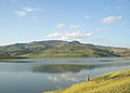 The Ain-dalia dam


Districts of Souk Ahras
[edit]
- Souk Ahras
- Hamma-Loulou
- An-Nasser
- Diar Ezzarga
- 1er Novembre 1954
- 5 Juillet
- 17 Octobre
- 20 Août
- 26 Avril 1958
- El-Allaouia
- Ibn Rochd
- Kouicem Abdelhak
- Sidi Messaoud
- Sidi Okba
- Et-Tagtaguia
Climate
[edit]Souk Ahras has a hot-summer Mediterranean climate (Köppen climate classification Csa) with warm summers and mild winters. Its proximity to the Mediterranean Sea aids in moderating the city's temperatures. As a result, Souk Ahras usually does not see the extreme temperatures that are experienced in the adjacent interior deserts. The climate of Souk Ahras, like that of other Atlas cities, features wet winters and dry summers. Souk Ahras on average receives roughly 840.74 mm (33.10 inches) of precipitation per year, the bulk of which is seen between October and April.
| Climate data for Souk Ahras (1991-2020) | |||||||||||||
|---|---|---|---|---|---|---|---|---|---|---|---|---|---|
| Month | Jan | Feb | Mar | Apr | May | Jun | Jul | Aug | Sep | Oct | Nov | Dec | Year |
| Record high °C (°F) | 24.5 (76.1) |
27.3 (81.1) |
30.6 (87.1) |
32.2 (90.0) |
37.9 (100.2) |
43.0 (109.4) |
43.7 (110.7) |
43.1 (109.6) |
43.0 (109.4) |
37.2 (99.0) |
29.0 (84.2) |
25.8 (78.4) |
43.7 (110.7) |
| Mean daily maximum °C (°F) | 11.6 (52.9) |
— | 15.4 (59.7) |
18.6 (65.5) |
23.6 (74.5) |
29.3 (84.7) |
33.4 (92.1) |
33.4 (92.1) |
28.2 (82.8) |
23.5 (74.3) |
16.9 (62.4) |
12.7 (54.9) |
— |
| Daily mean °C (°F) | 7.6 (45.7) |
7.9 (46.2) |
10.5 (50.9) |
13.2 (55.8) |
17.4 (63.3) |
22.4 (72.3) |
26.0 (78.8) |
26.3 (79.3) |
22.2 (72.0) |
18.0 (64.4) |
12.4 (54.3) |
8.8 (47.8) |
16.1 (61.0) |
| Mean daily minimum °C (°F) | 3.5 (38.3) |
— | 5.6 (42.1) |
7.7 (45.9) |
11.2 (52.2) |
15.5 (59.9) |
18.7 (65.7) |
19.1 (66.4) |
16.1 (61.0) |
12.6 (54.7) |
8.0 (46.4) |
4.9 (40.8) |
— |
| Record low °C (°F) | −5.7 (21.7) |
−6.1 (21.0) |
−1.5 (29.3) |
−1.2 (29.8) |
2.1 (35.8) |
7.0 (44.6) |
9.5 (49.1) |
10.5 (50.9) |
7.6 (45.7) |
3.0 (37.4) |
−0.5 (31.1) |
−4.2 (24.4) |
−6.1 (21.0) |
| Average precipitation mm (inches) | 118.2 (4.65) |
99.0 (3.90) |
85.3 (3.36) |
75.8 (2.98) |
60.2 (2.37) |
20.4 (0.80) |
7.0 (0.28) |
20.8 (0.82) |
42.8 (1.69) |
53.1 (2.09) |
82.0 (3.23) |
108.4 (4.27) |
773.0 (30.43) |
| Average precipitation days (≥ 1 mm) | 10.5 | 10.1 | 9.3 | 7.9 | 6.3 | 2.8 | 1.3 | 2.8 | 5.9 | 6.7 | 8.4 | 10.4 | 82.4 |
| Mean monthly sunshine hours | 153.2 | — | 208.4 | — | 277.9 | 311.0 | 348.7 | 318.4 | 239.5 | 221.6 | 169.5 | 142.6 | — |
| Source: NOAA[6] | |||||||||||||
Demographics
[edit]The inhabitants of the town of Souk Ahras are of Berber origin. They are mainly from the different regions of the wilaya of Souk Ahras and neighboring wilayas. The first tribes having established in Souk Ahras were known as the Papiria,[7] or Babiria from the name of Berber. They were composed of Causses and Syliactae.[8]
The tribes of Mousoulami, Kirina, Hnanchas, Hrakta have also lived here, all of them having Berber origins. These tribes lived in tents and practiced nomadism. They have established later and founded respective cities for themselves, including the town of Souk Ahras.
| Year | 1901 | 1926 | 1948 | 1954 | 1960 | 1966 | 1974 | 1977 | 1987 | 1998 | 2010 |
|---|---|---|---|---|---|---|---|---|---|---|---|
| Population | 7,500 | 10,600 | 17,025 | 20,700 | 22,800 | 34,400 | 52,100 | 57,173 | 80,015 | 115,882 | 157,329 |
Tourism
[edit]
Tourism in Souk Ahras focuses largely on a variety of historical and natural sites. In recent years it has become a destination for culture and health tourism. Landmarks include the Al-Aman mosque, the Thagaste bridge in the center of the city, the olive tree of St. Augustine, the corner of Sidi Massoud, and the cultural center. It is located 90 km (56 miles) from Annaba and its airport.
Related people
[edit]- Alypius of Thagaste, Christian bishop celebrated on August 15
- Apuleius, Hellenized Numidian author
- Saint Augustine of Hippo, Berber Christian author and Doctor of the Church
- Saïd Boualam, Algerian colonel in the French Army
- Chabane Boualleg, Algerian psychologist and senator
- Martianus Capella, Hellenized Roman author and Latin scholar
- Firmus and Rusticus, Christian martyrs of the 4th century
- Taoufik Makhloufi, middle distance runner and gold medalist at the 2012 Summer Olympics
- Saint Monica, Berber Christian and mother of Augustine
- Charles Pellat, French scholar and historian
- Tacfarinas, Numidian Berber who resisted the Roman invasions
- Ahmad al-Tifashi, Algerian author
- Tahar Ouettar, Algerian author
- Kateb Yacine, Algerian author
- Antar Yahia, Algerian footballer
- Salim Halali, Algerian Jewish musician
References
[edit]- ^ "A Berber, born in 354 at Thagaste (now Souk-Ahras) in Africa...", Fernand Braudel, A history of civilizations (1963), Penguin Books, 1995, p.335
- ^ "...he grew up in an area which was a center of Berber culture.", Augustinian studies, Volumes 7–8, Villanova University Press, 1976, p.134
- ^ Herbermann, Charles, ed. (1913). . Catholic Encyclopedia. New York: Robert Appleton Company.
- ^ A municipium was an existing city on which the citizenship had been conferred, while a colony was a new foundation or a community to which Roman settlers had been added
- ^ Nacéra Benseddik, Thagaste. Souk Ahras, ville natale de saint Augustin, Ed. Inas, Alger, 2005, p.25
- ^ "Souk Ahras Climate Normals 1991–2020". World Meteorological Organization Climatological Standard Normals (1991–2020). National Oceanic and Atmospheric Administration. Archived from the original on 27 September 2023. Retrieved 27 September 2023.
- ^ Enciclopedia italiana di scienze, lettere ed arti, Volume 33, Giovanni Gentile, Calogero Tumminelli, Istituto Giovanni Treccani, Rome online version
- ^ Vita Augostino di H'sen Dardour online version
Bibliography
[edit]- Nacéra Benseddik (2005). Thagaste. Souk Ahras, ville natale de saint Augustin. Algiers: Ed. Inas.
- Serge Lancel (2002). Saint Augustine, Hymns Ancient & Modern. Chapter I: Ltd. pp. 3–7.
- "The Martyrs of Madaura". Archived from the original on January 20, 2016. Retrieved July 18, 2012.
External links
[edit]- Official website
- Souk Ahras infosite, souk-ahras.info. Accessed 23 February 2024.
- Panoramio (Image gallery about Souk Shras and its region)
- Falling Rain Genomics, Inc. "Geographical information on Souk Ahras, Algeria". Retrieved 27 April 2008.
Places adjacent to Souk Ahras | ||||||||||||||||
|---|---|---|---|---|---|---|---|---|---|---|---|---|---|---|---|---|
| ||||||||||||||||
Capital: Souk Ahras | ||
| Districts | .svg) | |
| Communes | ||

| International | |
|---|---|
| National | |
| Geographic | |
| Other | |
Souk Ahras
View on GrokipediaSouk Ahras is a city in northeastern Algeria and the capital of Souk Ahras Province, with a population of 153,479 as of recent estimates.[1] It lies near the border with Tunisia in the Aurès Mountains region, covering an area within the province of approximately 4,360 square kilometers characterized by varied terrain suitable for agriculture.[2] Historically, the site corresponds to the ancient Numidian and Roman city of Thagaste, renowned as the birthplace of Augustine of Hippo in 354 AD, whose early life and education there influenced his later theological contributions.[3][4] The modern city developed on these ruins, serving as an agricultural hub with extensive land concessions for farming, including grains and olives, amid efforts to boost local investment and production.[5]
Etymology
Name Derivation and Historical Usage
The name Souk Ahras derives from the Arabic word souk, signifying "market," combined with the Berber term ahras, the plural of ahr or ahra meaning "lion," thus translating to "market of lions."[6] This etymology alludes to the historical abundance of lions in the surrounding Aures Mountains and forests, alongside the site's longstanding function as a regional trading hub.[7] In antiquity, the city bore the name Thagaste (or Tagaste), a Numidian and Roman designation originating from the Berber Thagoust or Tagost, which means "bag" or "sack," referring to its topographic enclosure amid three encircling mountains.[6] Archaeological evidence, including inscriptions from sites like Kaf Al-Masawrah, confirms continuous settlement under this name from prehistoric times through the Roman period, when it served as a municipium and birthplace of figures such as Saint Augustine in 354 CE.[6] The shift to Souk Ahras emerged post-Arab conquests in the 7th–8th centuries CE, reflecting linguistic fusion of Arabic administrative terminology with indigenous Berber elements amid Islamic expansion and Berber assimilation.[6] Additional historical appellations include Al-Sukra, possibly an early Arabic variant, and poetic references to an "African Palace," underscoring its perceived grandeur in medieval accounts.[6] The name has persisted through Ottoman, French colonial (retaining Souk Ahras in official usage from 1900), and post-independence Algerian administration without formal alteration.[8]History
Prehistory and Early Settlements
The Souk Ahras region exhibits evidence of prehistoric human occupation through rock art and associated artifacts, reflecting hunter-gatherer activities during the late Epipaleolithic or early Neolithic transition. A prominent site is Kaf Al-Masawrah, featuring giant petroglyphs dated to approximately 7000 BC, which depict a lion pursuing a pig and a fox, indicative of local fauna and predatory behaviors. These engravings span 15 meters in length and reach 2.93 meters in height, underscoring the scale of prehistoric artistic expression in the area. First documented and studied by explorer Burnel in 1892, the site was formally classified in 1928 as one of North Africa's key rock art locales, highlighting its role in regional prehistoric sequences.[6] Archaeological findings suggest continuity into early settlement phases with the arrival of proto-Berber groups, transitioning from nomadic to semi-sedentary patterns. Initial tribes identified in the locality include the Terina and Babyria, succeeded by the Hanansha and Haraqat, who established foundational communities amid the region's mountainous terrain and wadi systems. These groups, predating formalized Numidian polities, exploited natural resources for subsistence, laying groundwork for later cultural developments without evidence of urban infrastructure at this stage.[6] The Berber etymology of "Tagaste"—the ancient precursor to Souk Ahras, derived from "Tagost" meaning "bag" due to its encirclement by three mountains—reflects this era's linguistic and topographic imprint on early inhabitants.[6]Antiquity: Numidian and Roman Periods
Thagaste, the ancient settlement underlying modern Souk Ahras, emerged as a modest Numidian village inhabited by indigenous Berber tribes during the Kingdom of Numidia (c. 202 BC–46 BC).[6] These Numidians, skilled in cavalry warfare and agriculture, fostered trade ties with neighboring Carthaginians, exchanging goods like grain and livestock, while developing local construction techniques for fortifications and irrigation.[6] Under King Masinissa (r. 202–148 BC), who allied with Rome after the Battle of Zama in 202 BC, the region integrated into a unified Numidian state emphasizing olive cultivation and trans-Saharan routes, though Thagaste remained a peripheral tribal center rather than a major urban hub.[6] [9] Roman influence expanded into Numidia following Julius Caesar's victory over King Juba I at the Battle of Thapsus in 46 BC, leading to the province's formal establishment under Augustus around 27 BC as Numidia, encompassing northeastern Algeria.[9] Thagaste evolved into a Roman municipium by the late 3rd or early 4th century AD, functioning as a nodal point in the road network linking Carthage to the east and Hippo Regius (modern Annaba) to the north, facilitating the export of wheat, olives, and animal products to imperial markets.[10] [6] The town featured basic Roman infrastructure, including baths, aqueduct segments, and roads, reflecting modest urbanization amid Numidia's generally underdeveloped interior compared to coastal Proconsular Africa.[9] [6] Thagaste gained prominence as the birthplace of Augustine of Hippo on November 13, 354 AD, to a mixed Berber-Roman family, underscoring the province's cultural fusion of Punic, Berber, and Latin elements.[6] By the 4th century AD, it lay within Numidia Cirtensis, a subdivision emphasizing administrative stability, though archaeological evidence indicates limited monumental architecture locally, with grander sites like the theater at nearby Madaure (founded 75 AD under Vespasian) highlighting regional Roman investment in education and spectacle.[11] [6] The settlement persisted into late antiquity, supporting early Christian communities before Vandal incursions in the 5th century AD disrupted provincial economies reliant on agrarian exports.[9]Medieval and Ottoman Eras
Following the collapse of Roman authority in the 5th century, the region encompassing Thagaste (modern Souk Ahras) came under Vandal control after their conquest of North Africa in 439 AD, marking the onset of a period of Germanic rule characterized by Arian Christian dominance and economic disruption.[6] This Vandal kingdom endured until the Byzantine Empire's reconquest under Emperor Justinian I, beginning in 533 AD and solidifying around 534 AD, which aimed to reintegrate the territory into the Eastern Roman sphere and restore prosperity through administrative reforms and infrastructure projects.[6] Byzantine governance in the area featured defensive fortifications and ecclesiastical constructions, such as churches in nearby settlements like Khemissa and Tifache, reflecting efforts to consolidate control amid ongoing Berber resistance.[6] However, this era was short-lived, as Arab-Muslim armies invaded in the 7th century under generals like Uqba ibn Nafi, advancing from the east and clashing with Berber confederations including the Kasila and Dheina tribes; these campaigns facilitated the gradual Islamization of the population, evidenced by archaeological discoveries of pottery adorned with Arab-Islamic decorative styles.[6] Subsequent medieval centuries saw the region integrated into successive Islamic polities governing Ifriqiya and the central Maghreb, with local sites like Tifache linked to the Zirid dynasty by the 8th century onward, though Souk Ahras itself appears to have functioned primarily as a modest settlement rather than a major political center during these dynastic shifts from Umayyad to Aghlabid, Fatimid, and Zirid rule.[6] With the Ottoman Empire's expansion into North Africa, Souk Ahras was subsumed into the Beylik of Constantine in 1537 AD, one of three semi-autonomous provinces under the Regency of Algiers, where Ottoman influence remained indirect through appointed beys overseeing taxation and military levies.[6] Local governance relied on tribal intermediaries, particularly sheikhs from the Hanansha and Harakat clans, who facilitated tax collection without direct subordination to Istanbul; this arrangement fostered tensions, culminating in the Hanansha-led revolt against the Bey of Constantine under leader Al-Waznaji, a manifestation of Berber tribal autonomy that persisted amid sporadic unrest until the French conquest in 1843 AD.[6]Colonial Period and Independence Struggle
French forces occupied Souk Ahras in 1843, following military campaigns launched from Annaba and Constantine, integrating the region into French Algeria as part of the broader conquest initiated in 1830.[6] During the colonial era, the town developed as a settlement with infrastructure improvements, including connection to the Algerian railway in the late 19th century and construction of the Hôtel de Ville in 1887, exemplifying French administrative architecture.[12] The local Jewish community, present under French rule, largely emigrated to France by 1962 amid the escalating conflict.[13] In the lead-up to the Algerian War of Independence (1954–1962), Souk Ahras experienced early unrest, including an armed outbreak prompting Operation Bigeard in March 1956.[14] The region saw intense fighting during the Battle of Souk Ahras from April 28 to May 3, 1958, where French troops clashed with Algerian National Liberation Front (FLN) rebels near the town, resulting in 436 rebel deaths and 38 French casualties.[15] [16] French patrols operated in the surrounding hills to secure the Algeria-Tunisia border area, a key infiltration route for FLN fighters.[17] The war concluded with the Evian Accords on March 18, 1962, establishing a ceasefire and paving the way for Algerian independence on July 5, 1962, after which French settlers (pieds-noirs) departed en masse, including from Souk Ahras.[17] The conflict left the region war-scarred, with limited intercommunal contact persisting briefly post-independence.[18]Post-Independence Era
Following Algeria's independence in 1962, Souk Ahras underwent land reforms as part of the national agrarian revolution, which redistributed former colonial estates to local farmers and cooperatives, emphasizing cereals, olives, and livestock production in the region's fertile valleys.[19] These measures aimed to enhance food self-sufficiency but faced challenges from collectivization policies under Ahmed Ben Bella and Houari Boumediène, leading to variable yields until market-oriented adjustments in the 1980s.[20] The area's population expanded rapidly amid Algeria's overall demographic boom, with the urban center of Souk Ahras reaching approximately 155,000 residents by 2008, reflecting national trends of high fertility and rural-to-urban migration.[21] In 1984, Souk Ahras was designated a wilaya (province) under administrative reorganization, encompassing 13 daïras and bordering Tunisia, which facilitated localized governance for infrastructure and services.[22] Key projects included the Ain Dalia Dam on the Medjerda River, with construction starting in 1985 to bolster irrigation for agriculture and potable water supply in the arid northeast; the structure, holding 75 million cubic meters, was inaugurated in 2017.[23] [24] The University of Souk Ahras, founded in 1998, supported human capital development in a region historically reliant on agriculture.[25] Economic focus remained on primary sectors, with post-1990s stability enabling housing regularization in informal settlements like Lalaouia and Mesguiche to curb urban sprawl, though rural areas persisted with inadequate services such as water and electricity.[26] [27] By the 2000s, the wilaya's population approached 440,000, underscoring uneven modernization amid national hydrocarbon-driven growth.[20]Geography
Location and Physical Features
Souk Ahras Province occupies the northeastern extremity of Algeria, sharing its eastern border with Tunisia and northern boundary with El Taref Province, while adjoining Guelma Province to the west and Oum El Bouaghi Province to the south.[2] The province spans an area of 4,360 square kilometers, with its capital city situated at approximately 36°17′N latitude and 7°57′E longitude.[2] [28] The terrain of Souk Ahras exhibits varied physical characteristics, including a mountainous northern sector, central lowlands, and fertile plains in the south. Elevations average around 706 meters across the province, with the capital city at approximately 653 meters above sea level, contributing to a landscape prone to landslides in its hilly regions.[29] [30] The area is traversed by the Medjerda River, a significant waterway originating in the region and flowing eastward toward the Mediterranean via Tunisia, alongside features like the Ain Edalia Dam that support local hydrography.[31]Climate and Hydrography
Souk Ahras province exhibits a hot-summer Mediterranean climate (Köppen Csa), characterized by prolonged dry summers and relatively mild winters with higher precipitation. Average daily high temperatures vary from 12.1°C in January to 33.8°C in July, while lows range from 4.4°C in January to 20.4°C in July.[32] [33] Annual precipitation averages 354 mm, distributed over approximately 117 rainy days, predominantly from October to April, with minimal rainfall (around 7 mm) in July. Winters occasionally feature light snowfall, totaling about 60 mm annually, primarily in January. Relative humidity peaks at 75% in winter and drops to 45% in summer, with daily sunshine hours increasing from 5.8 in January to 12.2 in August.[32] The hydrography of the region centers on the Medjerda River, a principal North African waterway originating in Algeria and flowing eastward into Tunisia, supplemented by tributaries including the Mellegue, Echaref, and Laghdir wadis. The province lies within the Medjerda-Mellegue watershed, which supports surface water collection via dams such as Ain Dalia and Oued Chief, boasting a combined capacity exceeding 240 million cubic meters for urban supply, irrigation, and downstream springs fed by karstic limestone systems.[34] Groundwater resources are concentrated in aquifers like those at Taoura and Terreguellt, contributing to the area's relatively abundant water availability despite climatic variability.[34]Administrative Divisions
Souk Ahras Province, established as a wilaya through Algeria's 1984 administrative reorganization, is divided into 10 daïras (districts), which serve as intermediate administrative levels between the province and its communes.[35] These daïras collectively encompass 26 communes, functioning as the basic units of local governance responsible for municipal services, urban planning, and community administration. The structure reflects Algeria's centralized system, where daïras are headed by appointed sub-prefects overseeing multiple communes, while communes elect local assemblies. The daïras of Souk Ahras Province are:- Bir Bouhaouch
- Haddada
- M'daourouch
- Mechroha
- Merahna
- Ouled Driss
- Oum El Adhaïm
- Sedrata
- Souk Ahras (provincial capital daïra)
- Taoura
Demographics
Population Dynamics
The population of Souk Ahras Province stood at 438,127 according to the 2008 Algerian census conducted by the Office National des Statistiques (ONS).[37] This figure represented a 19.2% increase from the 367,455 residents enumerated in the 1998 census, corresponding to an average annual growth rate of about 1.7%.[37] Historical census data indicate steady expansion since independence, with populations of 296,077 in 1977 and 225,669 in 1966, reflecting post-colonial demographic recovery and high fertility rates typical of rural eastern Algerian wilayas.| Census Year | Population |
|---|---|
| 1966 | 225,669 |
| 1977 | 296,077 |
| 1998 | 367,455 |
| 2008 | 438,127 |