
Community hub
Recent from talks
Contribute something
Nothing was collected or created yet.
Envisat
View on Wikipedia
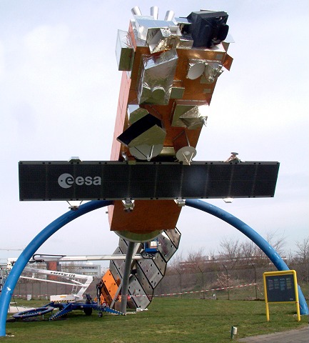
 Model of Envisat | |
| Mission type | Earth observation |
|---|---|
| Operator | ESA |
| COSPAR ID | 2002-009A |
| SATCAT no. | 27386 |
| Website | envisat |
| Mission duration | Planned: 5 years Final: 10 years, 1 month, 6 days |
| Spacecraft properties | |
| Manufacturer | Astrium |
| Launch mass | 8,211 kg (18,102 lb) |
| Dimensions | 26 × 10 × 5 m (85 × 33 × 16 ft) |
| Power | 6,500 watts |
| Start of mission | |
| Launch date | 1 March 2002, 01:07:59 UTC |
| Rocket | Ariane 5G V-145 |
| Launch site | Kourou ELA-3 |
| Contractor | Arianespace |
| End of mission | |
| Disposal | None |
| Declared | 9 May 2012 |
| Last contact | 8 April 2012 (spacecraft failure) |
| Decay date | ~150 years |
| Orbital parameters | |
| Reference system | Geocentric |
| Regime | Polar low Earth |
| Semi-major axis | 7,144.9 km (4,439.6 mi) |
| Eccentricity | 0.00042 |
| Perigee altitude | 772 km (480 mi) |
| Apogee altitude | 774 km (481 mi) |
| Inclination | 98.40 degrees |
| Period | 100.16 minutes |
| Repeat interval | 35 days |
| Epoch | 15 December 2013, 03:07:00 UTC[1] |
| Instruments | |
Envisat ("Environmental Satellite") is a large Earth-observing satellite which has been inactive since 2012. It was launched on 1 March 2002 aboard an Ariane 5 from the Guyana Space Centre in Kourou, French Guiana, into a Sun synchronous polar orbit at an altitude of 790 ± 10 km.
Operated by the European Space Agency (ESA), it was the world's largest civilian Earth observation satellite.[2] Its objective was to support the continuity of European Remote-Sensing Satellite missions, providing additional observations to improve environmental studies. To accomplish the global and regional objectives of the mission, numerous scientific disciplines used the data acquired from the sensors on the satellite to study atmospheric chemistry, ozone depletion, biological oceanography, ocean temperature and colour, wind waves, hydrology (humidity, floods), agriculture and arboriculture, natural hazards, digital elevation modelling (using interferometry), monitoring of maritime traffic, atmospheric dispersion modelling (pollution), cartography and snow and ice.
Envisat malfunctioned before it could be deorbited,[3] and after losing contact with the satellite on 8 April 2012, ESA formally announced the end of Envisat's mission on 9 May 2012.[4] The defunct satellite is considered space debris and orbits the Earth in about 101 minutes, with a repeat cycle of 35 days. An analysis that determined the 50 "statistically most concerning" debris objects in low Earth orbit ranked Envisat in 21st place.[3]
Envisat was able to operate five years beyond its planned mission lifetime, delivering over a petabyte of data.[4] At the time of its failure, Envisat had cost a total of 2.5 billion euro to develop, launch, and operate.[5] The mission has been replaced by the Sentinel series of satellites. The first of these, Sentinel 1, has taken over the radar duties of Envisat since its launch in 2014.
Mission
[edit]Envisat was launched as an Earth observation satellite. Its objective was to support the continuity of European Remote-Sensing Satellite missions, providing additional observations to improve environmental studies.
To accomplish the global and regional objectives of the mission, numerous scientific disciplines used the data acquired from the sensors on the satellite to study atmospheric chemistry, ozone depletion, biological oceanography, ocean temperature and colour, wind waves, hydrology (humidity, floods), agriculture and arboriculture, natural hazards, digital elevation modelling (using interferometry), monitoring of maritime traffic, atmospheric dispersion modelling (pollution), cartography and snow and ice.
Specifications
[edit]- Dimensions
26 m (85 ft) × 10 m (33 ft) × 5 m (16 ft) in orbit with the solar array deployed.[6]
- Mass
8,211 kg (18,102 lb), including 319 kg (703 lb) of fuel and a 2,118 kg (4,669 lb) instrument payload.[7]
- Power
Solar array with a total load of 3560 W.
Instruments
[edit]
This section needs additional citations for verification. (August 2020) |
Envisat carries an array of nine Earth-observation instruments that gathered information about the Earth (land, water, ice, and atmosphere) using a variety of measurement principles. A tenth instrument, DORIS, provided guidance and control. Several of the instruments were advanced versions of instruments that were flown on the earlier ERS-1 and ERS 2 missions and other satellites.
MWR
[edit]MWR (Microwave Radiometer) was designed for measuring water vapour in the atmosphere.
AATSR
[edit]AATSR (Advanced Along Track Scanning Radiometer) can measure the sea surface temperature in the visible and infrared spectra. It is the successor of ATSR1 and ATSR2, payloads of ERS 1 and ERS 2. AATSR can measure Earth's surface temperature to a precision of 0.3 K (0.54 °F), for climate research. Among the secondary objectives of AATSR is the observation of environmental parameters such as water content, biomass, and vegetal health and growth.
MIPAS
[edit]MIPAS (Michelson Interferometer for Passive Atmospheric Sounding) is a Fourier transforming infrared spectrometer which provides pressure and temperature profiles, and profiles of trace gases nitrogen dioxide (NO
2), nitrous oxide (N
2O), methane (CH
4), nitric acid (HNO
3), ozone (O
3), and water (H
2O) in the stratosphere. The instrument functions with high spectral resolution in an extended spectral band, which allows coverage across the Earth in all seasons and at equal quality night and day. MIPAS has a vertical resolution of 3 to 5 km (2 to 3 mi) depending on altitude (the larger at the level of the upper stratosphere).
MERIS
[edit]MERIS (MEdium Resolution Imaging Spectrometer) measures the reflectance of the Earth (surface and atmosphere) in the solar spectral range (390 to 1040 nm) and transmits 15 spectral bands back to the ground segment. MERIS was built at the Cannes Mandelieu Space Center.
SCIAMACHY
[edit]SCIAMACHY (SCanning Imaging Absorption spectroMeter for Atmospheric CHartographY) compares light coming from the sun to light reflected by the Earth, which provides information on the atmosphere through which the Earth-reflected light has passed.
SCIAMACHY is an image spectrometer with the principal objective of mapping the concentration of trace gases and aerosols in the troposphere and stratosphere. Rays of sunlight that are reflected transmitted, backscattered and reflected by the atmosphere are captured at a high spectral resolution (0.2 to 0.5 nm) for wavelengths between 240 and 1700 nm, and in certain spectra between 2,000 and 2,400 nm. Its high spectral resolution over a wide range of wavelengths can detect many trace gases even in tiny concentrations. The wavelengths captured also allow effective detection of aerosols and clouds. SCIAMACHY uses 3 different targeting modes: to the nadir (against the sun), to the limbus (through the atmospheric corona), and during solar or lunar eclipses. SCIAMACHY was built by Netherlands and Germany at TNO/TPD, SRON and Airbus Defence and Space Netherlands.[8]
RA-2
[edit]RA-2 (Radar Altimeter 2) is a dual-frequency Nadir pointing Radar operating in the Ku band and S bands, it is used to define ocean topography, map/monitor sea ice and measure land heights.
Mean sea level measurements from Envisat are continuously graphed at the Centre National d'Etudes Spatiales web site, on the Aviso page.
ASAR
[edit]ASAR (Advanced Synthetic Aperture Radar) operates in the C band in a wide variety of modes. It can detect changes in surface heights with sub-millimeter precision. It served as a data link for ERS 1 and ERS 2, providing numerous functions such as observations of different polarities of light or combining different polarities, angles of incidence and spatial resolutions.
| Mode | Id | Polarisation | Incidence | Resolution | Swath |
|---|---|---|---|---|---|
| Alternating polarisation | AP | HH/VV, HH/HV, VV/VH | 15–45° | 30–150 m | 58–110 km |
| Image | IM | HH, VV | 15–45° | 30–150 m | 58–110 km |
| Wave | WV | HH, VV | 400 m | 5 km × 5 km | |
| Suivi global (ScanSAR) | GM | HH, VV | 1000 m | 405 km | |
| Wide Swath (ScanSAR) | WS | HH, VV | 150 m | 405 km |
These different types of raw data can be given several levels of treatment (suffixed to the ID of the acquisition mode: IMP, APS, and so on):
- RAW (raw data, or "Level 0"), which contains all the information necessary to create images.
- S (complex data, "Single Look Complex"), images in complex numeric form, the real and imaginary parts of the output of the compression algorithm
- P (precision image), amplified image with constant pixel width (12.5 m for IMP)
- M (medium precision image), amplified radiometry image with a resolution greater than P
- G (geocoded image), amplified image to which simple geographical transforms have been applied to show relief.
Data capture in WV mode is unusual in that they constitute a series of 5 km × 5 km spaced at 100 km.
DORIS
[edit]DORIS (Doppler Orbitography and Radiopositioning Integrated by Satellite) determines the satellite's orbit to within 10 cm (4 in).
GOMOS
[edit]GOMOS (Global Ozone Monitoring by Occultation of Stars) looks at stars as they descend through the Earth's atmosphere and change colour, allowing measurement of gases such as ozone (O
3), including their vertical distribution.
GOMOS uses the principle of occultation. Its sensors detect light from a star traversing the Earth's atmosphere and measures the depletion of that light by trace gases nitrogen dioxide (NO
2), nitrogen trioxide, (NO
3), OClO), ozone (O
3) and aerosols present between about 20 to 80 km (12 to 50 mi) altitude. It has a resolution of 3 km (1.9 mi).
End of mission
[edit]Loss of contact
[edit]ESA announced on 12 April 2012 that they lost contact with Envisat on Sunday, 8 April 2012, after 10 years of service, exceeding the initially planned life span by 5 years. The spacecraft was still in a stable orbit, but attempts to contact it were unsuccessful.[9][10] Ground-based radar and the French Pleiades Earth probe were used to image the silent Envisat and look for damage.[11] ESA formally announced the end of Envisat's mission on 9 May 2012.[4]
Envisat was launched in 2002 and it operated five years beyond its planned mission lifetime, delivering over a petabyte of data.[4] ESA was planning to operate the spacecraft until 2014.[5]
Space safety
[edit]
The defunct Envisat satellite is considered space debris and orbits the Earth in about 101 minutes, with a repeat cycle of 35 days. It poses a hazard because of the risk of collisions. Given its orbit and its area-to-mass ratio, it will take about 150 years for the satellite to be gradually pulled into the Earth's atmosphere.[12] Envisat is currently orbiting in an environment where two catalogued space debris objects can be expected to pass within about 200 m (660 ft) of it every year, which would likely trigger the need for a manoeuvre to avoid a possible collision.[13] A collision between a satellite the size of Envisat and an object as small as 10 kg could produce a very large cloud of debris, initiating a self-sustaining chain-reaction of collisions and fragmentation with production of new debris, a phenomenon known as the Kessler Syndrome.[13] An analysis that determined the 50 "statistically most concerning" debris objects in low Earth orbit ranked Envisat in 21st place.[3]
Envisat was a candidate for a mission to remove it from orbit, called e.Deorbit. The spacecraft sent to bring down Envisat would itself need to have a mass of approximately 1.6 tonnes.[14]
See also
[edit]References
[edit]- ^ "ENVISAT Satellite details 2002-009A NORAD 27386". N2YO. 15 December 2013. Retrieved 15 December 2013.
- ^ EarthNet Online
- ^ a b c Foust, Jeff (13 October 2020). "Upper stages top list of most dangerous space debris". Space News. Retrieved 12 December 2022.
- ^ a b c d "ESA declares end of mission for Envisat". ESA. 9 May 2012.
- ^ a b Contact lost with flagship Envisat spacecraft 12 April 2012.
- ^ "EnviSat (Environmental Satellite)". eoPortal.
- ^ Envisat – Overall configuration
- ^ "I - Sciamachy".
- ^ "Breaking News | Flagship Envisat satellite stops communicating". Spaceflight Now. Retrieved 21 April 2012.
- ^ "ESA Portal – Envisat services interrupted". Esa.int. Retrieved 21 April 2012.
- ^ Huge, Mysteriously Silent Satellite Spotted by Another Spacecraft Space.com article, 20 April 2012
- ^ "Envisat To Pose Big Orbital Debris Threat for 150 Years, Experts Say." SpaceNews. Retrieved: 27 September 2015.
- ^ a b Gini, Andrea (25 April 2012). "Don Kessler on Envisat and the Kessler Syndrome". Space Safety Magazine. Retrieved 9 May 2012.
- ^ "e.Deorbit Symposium". ESA. 6 May 2014. Archived from the original on 1 July 2015. Retrieved 2 June 2015.
External links
[edit]- Envisat homepage at ESA
- Envisat operations page at ESA
- Miravi – Meris Image Rapid Visualization. MIRAVI shows the gallery of images generated on the Level0 (raw data) Meris Full Resolution (300m) products, few seconds after their availability.
- SRRS – Satellite Rapid Response System. Like MIRAVI but including also ASAR, MERIS Full and Reduced Resolution and ALOS AVNIR2 images.
- Earth Snapshot – Web Portal dedicated to Earth Observation. Includes commented satellite images, information on storms, hurricanes, fires and meteorological phenomena.
- ESA SNAP Toolbox for viewing, calibrating and analyzing Envisat ASAR Level 1 data and higher
- Four years on, Envisat hailed for its contribution to Earth science Physorg.com (2006-02-28)
- ESA Envisat DDS (Data Dissemination System)
- gcs Global Communication & Services – Manufacturer of the Envisat DDS Commercial Receiver Kit for ENVIHAM Home Users
- Dossier Envisat: 10 years of climate and environmental research at Astrium
- Envisat article on eoPortal by ESA
| |||||||||||||||||||||||
| |||||||||||||||||||||||
Future missions in italics
| |||||||||||||||||||||||
| International | |
|---|---|
| National | |
| Other | |
Envisat
View on GrokipediaMission Overview
Objectives and Background
Envisat, the Environmental Satellite, was developed as part of the European Space Agency's (ESA) Earth observation efforts, with initial work on its Polar Platform beginning in 1990 and the full mission configuration approved following the ESA Ministerial Council in December 1993, which split the original POEM-1 concept into Envisat and the meteorological MetOp program.[2] The spacecraft was constructed by a European industrial consortium led by Astrium (now part of Airbus Defence and Space), involving companies from 14 countries including Austria, Belgium, Canada, Denmark, France, Finland, Germany, Italy, the Netherlands, Norway, Spain, Sweden, Switzerland, and the United Kingdom.[4] The total development and launch cost amounted to approximately €2.3 billion, encompassing €2 billion for the program and an additional €300 million for five years of operations.[4] Phase C/D contracts for the platform and payload were signed in July 1995, building on heritage from earlier missions like SPOT 4.[2] The primary mission objectives centered on providing continuity and enhancement to the data from ESA's European Remote-Sensing Satellites (ERS-1 and ERS-2), launched in 1991 and 1995 respectively, by delivering advanced observations of Earth's atmosphere, oceans, land surfaces, and ice cover.[4] Envisat aimed to support environmental and climate studies, including monitoring ozone depletion, sea level rise, vegetation dynamics, and the impacts of natural disasters such as floods and volcanic eruptions.[5] These goals were pursued through synergistic measurements from its suite of instruments, enabling both global-scale environmental tracking and precise regional assessments for pollution and resource management.[5] As a non-commercial research mission within ESA's broader Earth observation framework, Envisat was designed to generate long-term datasets essential for understanding global change processes, with an emphasis on interdisciplinary applications across hydrology, oceanography, and atmospheric chemistry.[2] It contributed to initiatives like the Global Monitoring for Environment and Security (GMES) program by providing foundational data for climate modeling, ecosystem analysis, and policy-relevant insights into phenomena such as global warming and biodiversity shifts.[5] Over its operational life, the mission amassed more than a petabyte of data, fostering advancements in Earth system science without direct commercial ties.[2]Launch and Orbital Parameters
Envisat was launched on March 1, 2002, at 01:07:59 UTC from the Guiana Space Centre in Kourou, French Guiana, aboard an Ariane 5 rocket designated as flight V-505.[6] The satellite had an initial launch mass of 8,211 kg, including payloads and propellants, making it one of the heaviest Earth observation satellites deployed at the time.[6] The Ariane 5 successfully placed Envisat into its initial transfer orbit, marking the culmination of a multi-year development effort by the European Space Agency (ESA) to advance global environmental monitoring. The satellite operated in a sun-synchronous, near-polar orbit designed to provide consistent lighting conditions for Earth observations. Key parameters included an altitude ranging from 782 to 800 km, an inclination of 98.55°, and an orbital period of 100.6 minutes, enabling a 35-day repeat cycle over the Earth's surface.[2] The orbit featured a mean local solar time of 10:00 a.m. at the descending node, ensuring optimal solar illumination for instrument operations.[2] Over its mission lifetime, Envisat completed more than 50,000 orbits, covering a cumulative distance exceeding 2.5 billion kilometers.[2] Following launch, Envisat underwent a commissioning phase that extended until December 2002, during which initial orbit insertion maneuvers were performed using the spacecraft's onboard bipropellant propulsion system to fine-tune its trajectory and achieve the nominal operational orbit.[7] These adjustments included corrections for inclination, eccentricity, and altitude deviations from the reference orbit, stabilizing the satellite at its target parameters within weeks of deployment.[8] By the end of this phase, routine operations commenced, with the propulsion system thereafter used periodically for orbit maintenance to counteract atmospheric drag and gravitational perturbations.[7]Spacecraft Design
Specifications
Envisat was designed as a large polar-orbiting satellite, measuring 26 meters in length including its deployed solar array, 10 meters in width, and 5 meters in height in its operational configuration.[2] In launch configuration, it had a length of 10.5 meters and an envelope diameter of 4.57 meters.[2] The spacecraft's total mass at launch was 8,140 kg, including 319 kg of hydrazine propellant, with a dry mass of 7,821 kg.[2][9] The payload, comprising instruments and interfacing hardware, accounted for 2,050 kg of this mass.[2] The power system generated up to 6.5 kW at end-of-life through a single-sided solar array measuring 14 meters by 5 meters, composed of silicon solar cells deployed as a single wing with 14 rigid panels.[2][7] This array provided an average of 6 kW in sunlight, supplemented by eight 40 Ah nickel-cadmium (NiCd) batteries for eclipse periods, delivering up to 3 kW.[7][2] The payload instruments required an average of 1.9 kW during both sunlight and eclipse phases, with a peak demand of 4.1 kW.[2] Communication was handled via X-band channels for high-rate payload data transmission, supporting up to two simultaneous links at 100 Mbps each (full RF channel) or 50 Mbps (half channel), and Ka-band for additional data relay at similar rates.[2][7] Telemetry, tracking, and command (TT&C) used S-band at 2 kbps uplink and 4 kbps downlink rates.[10] Onboard data handling included two solid-state recorders, each with 70 Gbits capacity at beginning-of-life (60 Gbits at end-of-life), and a backup tape recorder with 30 Gbits, enabling storage of up to 170 Gbits total for mission data before downlink.[2][4]| Specification Category | Details |
|---|---|
| Dimensions (In-Orbit) | 26 m (length with solar array) × 10 m (width) × 5 m (height)[2] |
| Dimensions (Launch) | 10.5 m (length) × 4.57 m (diameter)[2] |
| Mass (Total at Launch) | 8,140 kg (including 319 kg hydrazine)[2] |
| Mass (Dry) | 7,821 kg[9] |
| Payload Mass | 2,050 kg[2] |
| Power Generation | 6.5 kW (end-of-life, solar array: 14 m × 5 m, silicon cells)[2][7] |
| Eclipse Power | 3 kW (eight 40 Ah NiCd batteries)[7][2] |
| Payload Power | 1.9 kW average; 4.1 kW peak[2] |
| Data Transmission (X-band/Ka-band) | Up to 100 Mbps per channel (two channels each)[7][2] |
| TT&C (S-band) | 2 kbps (uplink); 4 kbps (downlink)[10] |
| Onboard Storage | Two SSRs (70 Gbits each BOL); one tape recorder (30 Gbits)[2] |