

Community hub
Recent from talks
Contribute something
Nothing was collected or created yet.
Ningxia
View on Wikipedia
Key Information


.svg)
| Ningxia | |||||||||||||||||||||||||||||||||||||||||||||||||
|---|---|---|---|---|---|---|---|---|---|---|---|---|---|---|---|---|---|---|---|---|---|---|---|---|---|---|---|---|---|---|---|---|---|---|---|---|---|---|---|---|---|---|---|---|---|---|---|---|---|
.svg) "Ningxia" in simplified (top) and traditional (bottom) Chinese characters | |||||||||||||||||||||||||||||||||||||||||||||||||
| Simplified Chinese | 宁夏 | ||||||||||||||||||||||||||||||||||||||||||||||||
| Traditional Chinese | 寧夏 | ||||||||||||||||||||||||||||||||||||||||||||||||
| Xiao'erjing | نِئٍثِيَا | ||||||||||||||||||||||||||||||||||||||||||||||||
| Hanyu Pinyin | Níngxià | ||||||||||||||||||||||||||||||||||||||||||||||||
| Postal | Ningsia | ||||||||||||||||||||||||||||||||||||||||||||||||
| Literal meaning | "Pacified Xia" | ||||||||||||||||||||||||||||||||||||||||||||||||
| |||||||||||||||||||||||||||||||||||||||||||||||||
| Official name | |||||||||||||||||||||||||||||||||||||||||||||||||
| Simplified Chinese | 宁夏回族自治区 | ||||||||||||||||||||||||||||||||||||||||||||||||
| Traditional Chinese | 寧夏回族自治區 | ||||||||||||||||||||||||||||||||||||||||||||||||
| Xiao'erjing | نِئٍثِيَا خُوِزُو زِجِٿِيُوِ | ||||||||||||||||||||||||||||||||||||||||||||||||
| Hanyu Pinyin | Níngxià Huízú Zìzhìqū | ||||||||||||||||||||||||||||||||||||||||||||||||
| Postal | Ningsia Hui Autonomous Region | ||||||||||||||||||||||||||||||||||||||||||||||||
| |||||||||||||||||||||||||||||||||||||||||||||||||
Ningxia,[a] officially the Ningxia Hui Autonomous Region, is an autonomous region in Northwestern China. Formerly a province, Ningxia was incorporated into Gansu in 1954 but was later separated from Gansu in 1958 and reconstituted as an autonomous region for the Hui people, one of the 56 officially recognised nationalities of China. Twenty percent of China's Hui population lives in Ningxia.[7]
Ningxia is bounded by Shaanxi to the east, Gansu to the south and west and Inner Mongolia Autonomous Region to the north and has an area of around 66,400 square kilometres (25,600 sq mi).[1] This sparsely settled, mostly desert region lies partially on the Loess Plateau and in the vast plain of the Yellow River and features the Great Wall of China along its northeastern boundary. Over about 2000 years, an extensive system of canals (with a total length of approximately 1397 kilometers)[8] has been built from Qin dynasty. Extensive land reclamation and irrigation projects have made increased cultivation possible. The arid region of Xihaigu, which covers large parts of the province, suffers from severe water shortage, which the canals were intended to alleviate.[9]
Ningxia was the core area of the Western Xia in the 11th–13th centuries, established by the Tangut people; its name, "Peaceful Xia", derived from the Mongol conquest of the state.[10] The Tanguts made significant achievements in literature, art, music, and architecture, and in particular, invented Tangut script. Long one of the country's poorest areas, a small winemaking industry has become economically important since the 1980s. Before the arrival of viticulture, Ningxia's 6.8 million people, 36 per cent of whom are Muslims from the Hui ethnic group, relied largely on animal grazing, subsistence agriculture and the cultivation of wolfberries used in traditional Chinese medicine. Since then, winemaking has become the premier specialty of Ningxia, and the province devotes almost 40,000 hectares to vineyards and producing 120 million bottles of wine in 2017 – a quarter of the entire nation's production.[11]
History
[edit]The earliest human activity in Ningxia can be traced back to 30,000 years ago, with remains of the Shuidonggou Culture found in Lingwu.[12]

As a frontier zone between nomadic pastoralists and sedentary farmers, Ningxia was a frequent seat of war and incursions by non-Chinese tribes. Ningxia and its surrounding areas were incorporated into the Qin as the Beidi Commandery as early as the 3rd century BC. To pacify the region, the imperial government established military colonies to reclaim land. In addition, horse pasturages were founded under the Imperial Stud to safeguard the supply of army horses, as early as the Western Han dynasty (206 BC – AD 9).[13] Throughout the Han dynasty and the Tang dynasty there were several large cities established in the region. The Liang Province rebellion at the end of the Han Dynasty affected Ningxia.
By the 11th century the Tangut people had established the Western Xia dynasty on the outskirts of the then-Song dynasty. Jews also lived in Ningxia, as evidenced by the fact that in 1489, after a major flood destroyed Torah scrolls in Kaifeng, a replacement set was sent to the Kaifeng Jews by the Ningbo and Ningxia Jewish communities.[14]
It then came under Mongol domination after Genghis Khan conquered Yinchuan in the early 13th century. Muslims from Central Asia also began moving into Ningxia from the west. By the late 17th century, Ningxia had become a weaving centre, producing many early Chinese carpets.[15] The Muslim Dungan Revolt of the 19th century affected Ningxia.
In 1914, Ningxia was merged with the province of Gansu. In 1928, it became a separate province. Between 1914 and 1928, the Ma clique ruled the provinces of Qinghai, Ningxia and Gansu; General Ma Hongkui was the military governor of Ningxia and had absolute authority in the province. The Muslim conflict in Gansu, which lasted from 1927 to 1930, spilt over into Ningxia. In 1934, warlord and National Revolutionary Army general Sun Dianying attempted to conquer the province, but was defeated by an alliance led by the Ma clique.[16]
From 1950 to 1958, a Kuomintang Islamic insurgency resulted in fighting throughout Northwest China, including Ningxia. In 1954, the Chinese government merged Ningxia with Gansu, but in 1958 Ningxia formally became an autonomous region of China. In 1969, Ningxia received a part of the Inner Mongolian Autonomous Region, but this area was returned in 1979.
A number of Chinese artifacts dating from the Tang dynasty and Song dynasty, some of which had been owned by Emperor Zhenzong, were excavated and then came into the hands of Ma Hongkui, who refused to publicize the findings. Among the artifacts were a white marble tablet from the Tang dynasty, gold nails, and bands made out of metal. It was not until after Ma Hongkui died that his wife went to Taiwan in 1971 from America to bring the artifacts to Chiang Kai-shek, who turned them over to the Taipei National Palace Museum.[17]
Geography
[edit]
Present-day Ningxia is one of the nation's smallest provincial-level units and borders the provinces of Shaanxi and Gansu and the Inner Mongolia Autonomous Region. At 3556 meters above sea level, Aobaogeda (敖包疙瘩) in the Helan Mountains is the highest point in Ningxia.[18]
Ningxia is a relatively dry, desert-like region and features a diverse geography of forested mountains and hills, table lands, deserts, flood plains and basins cut through by the Yellow River. The Ningxia ecosystem is one of the least studied regions in the world. Significant irrigation supports the growing of wolfberries, a commonly consumed fruit throughout the region. Ningxia's deserts include the Tengger desert in Shapotou.
The northern section, through which the Yellow River flows, supports the best agricultural land. A railroad, linking Lanzhou with Baotou, crosses the region. A highway has been built across the Yellow River at Yinchuan.
On 16 December 1920, the Haiyuan earthquake, 8.6 magnitude, at 36°36′N 105°19′E / 36.6°N 105.32°E, initiated a series of landslides that killed an estimated 200,000 people. Over 600 large loess landslides created more than 40 new lakes.[19][20]
| Part of a series on Islam in China |
|---|
 |
|
|
Grasslands
[edit]It was reported that approximately 34 percent (33.85 million mu; 22,600 km2) of the region's total surface consisted of grassland.[21] This figure is down from approximately 40 percent in the 1990s. The grasslands are spread over the dry desert-steppe area in the northeast (which forms a part of the Inner Mongolian steppe region), and the hilly pastures located on the semi-arid Loess Plateau in the south.[22] It is ascertained that the grasslands of Ningxia have been degraded to various degrees.[23] Scientists debate the extent to which this degradation occurs over space and time.[24] Historical research has also found limited evidence of expanding grassland degradation and desertification in Ningxia.[13][25] A major component of land management in Ningxia is a ban on open grazing, which has been in place since 2003.[26] The ecological and socio-economic effects of this Grazing Ban in relation to the grasslands and pastoralists' livelihood are contested.[22] The ban stipulates that animal husbandry be limited to enclosed pens and no open grazing be permitted in certain time periods set by the Autonomous Region's People's Government.
Climate
[edit]| Taole | ||||||||||||||||||||||||||||||||||||||||||||||||||||||||||||
|---|---|---|---|---|---|---|---|---|---|---|---|---|---|---|---|---|---|---|---|---|---|---|---|---|---|---|---|---|---|---|---|---|---|---|---|---|---|---|---|---|---|---|---|---|---|---|---|---|---|---|---|---|---|---|---|---|---|---|---|---|
| Climate chart (explanation) | ||||||||||||||||||||||||||||||||||||||||||||||||||||||||||||
| ||||||||||||||||||||||||||||||||||||||||||||||||||||||||||||
| ||||||||||||||||||||||||||||||||||||||||||||||||||||||||||||
The region is 1,200 kilometres (750 mi) from the sea and has an arid continental climate on the north to humid continental climate to the south, with average summer temperatures rising to 17 to 24 °C (63 to 75 °F) in July and average winter temperatures dropping to between −7 and −15 °C (19 and 5 °F) in January. Seasonal extreme temperatures can reach 39 °C (102 °F) in summer and −30 °C (−22 °F) in winter. The diurnal temperature variation can reach above 17 °C (31 °F), especially in spring. Annual rainfall averages from 190 to 700 millimetres (7.5 to 27.6 in), with more rain falling in the south of the region.
Mineral resources
[edit]Ningxia is rich in mineral resources with proven deposits of 34 kinds of minerals, much of which located in grassland areas.[22] In 2011 it was estimated that the potential value per capita of these resources accounted for 163.5 percent of the nation's average. Ningxia boasts verified coal reserves of over 30 billion tons, with an estimated reserve of more than 202 billion tons, ranking sixth nationwide. Coal deposits are spread over one-third of the total surface of Ningxia, and mined in four major fields in the Helan and Xiangshan mountains, Ningdong and Yuanzhou (or Guyuan). The region's reserves of oil and natural gas can be found in Yanchi and Lingwu County, and are ideal for large-scale development of oil, natural gas and chemical industries. Ningxia leads China in gypsum deposits, with a proven reserve of more than 4.5 billion tons, of which the rarely found, top-grade gypsum accounts for half of the total deposits. The Hejiakouzi deposit in Tongxin County features a reserve of 20 million tons of gypsum with a total thickness of 100 meters. There is a considerable deposit of quartz sandstone, of which 17 million tons have been ascertained. In addition, there are phosphorus, flint, copper, iron, barite, other minerals and Helan stone – a special clay stone.[10][28]
Politics
[edit]Like all governing institutions in mainland China, Ningxia has a parallel party-government system,[29] in which the CCP Ningxia Regional Committee Secretary outranks the Government Chairman.[30] The CCP Ningxia Regional Committee acts as the top policy-formulation body, and has control over the Ningxia Hui Autonomous Region People's Government.
Administrative divisions
[edit]Ningxia is divided into five prefecture-level divisions: all prefecture-level cities:
| Administrative divisions of Ningxia | ||||||||
|---|---|---|---|---|---|---|---|---|
| Division code[31] | Division | Area in km2[32] | Population 2020[33] | Seat | Divisions[34] | |||
| Districts | Counties | CL cities | ||||||
| 640000 | Ningxia Hui Autonomous Region | 66,400.00 | 7,202,654 | Yinchuan city | 9 | 11 | 2 | |
| 640100 | Yinchuan city | 8,874.61 | 2,859,074 | Jinfeng District | 3 | 2 | 1 | |
| 640200 | Shizuishan city | 5,208.13 | 751,389 | Dawukou District | 2 | 1 | ||
| 640300 | Wuzhong city | 21,420.14 | 1,382,713 | Litong District | 2 | 2 | 1 | |
| 640400 | Guyuan city | 13,449.03 | 1,142,142 | Yuanzhou District | 1 | 4 | ||
| 640500 | Zhongwei city | 17,448.09 | 1,067,336 | Shapotou District | 1 | 2 | ||

| Administrative divisions in Chinese and varieties of romanizations | ||||
|---|---|---|---|---|
| English | Chinese | Pinyin | Xiao'erjing | |
| Ningxia Hui Autonomous Region | 宁夏回族自治区 | Níngxià Huízú Zìzhìqū | نِئٍثِيَا خُوِزُو زِجِٿِيُوِ | |
| Yinchuan city | 银川市 | Yínchuān Shì | ءٍچُوًا شِ | |
| Shizuishan city | 石嘴山市 | Shízuǐshān Shì | شِظُوِشًا شِ | |
| Wuzhong city | 吴忠市 | Wúzhōng Shì | وُجْو شِ | |
| Guyuan city | 固原市 | Gùyuán Shì | قُيُوًا شِ | |
| Zhongwei city | 中卫市 | Zhōngwèi Shì | جْووِ شِ | |
The five prefecture-level cities of Ningxia are subdivided into 22 county-level divisions (9 districts, 2 county-level cities, and 11 counties).
Urban areas
[edit]| Population by urban areas of prefecture & county cities | ||||
|---|---|---|---|---|
| # | Cities | 2020 Urban area[35] | 2010 Urban area[36] | 2020 City proper |
| 1 | Yinchuan | 1,230,650 | 1,159,457 | 2,859,074 |
| 2 | Shizuishan | 422,043 | 403,901 | 751,389 |
| 3 | Wuzhong | 400,677 | 232,134 | 1,382,713 |
| 4 | Guyuan | 267,810 | 130,155 | 1,142,142 |
| 5 | Zhongwei | 249,307 | 160,279 | 1,067,336 |
| 6 | Lingwu | 200,920 | 125,976 | see Yinchuan |
| 7 | Qingtongxia | 142,349 | 99,367 | see Wuzhong |
Economy
[edit]
Rural Ningxia was for long an officially designated poverty area, and remains on the lower rungs of the developmental ladder.[22] Its nominal GDP in 2023 was 531.50 billion yuan (US$75.43 billion) and its per capita GDP 72,957 yuan (US$10,353). It comprises 0.42% of the national economy.
Agriculture
[edit]Similar to other areas, Ningxia has seen a gradual decline of its peasant population due to rural–urban migration. Despite this, the great majority (62.8 percent) was still agricultural at the time of the survey.[37] Animal husbandry is important for the regional economy. In the main pastoral county, Yanchi, it is even the leading industry when specified for the primary sector. The dominant grazing animals are sheep and goat.[38] In the (semi-)pastoral regions, herders engage in a mixed sedentary farming operation of dryland agriculture and extensive animal husbandry, while full nomadic pastoralism is no longer practiced.[22] Since a cattle breeding plan was implemented in 2002, the province has become one of China's main dairy production areas.[39][40]
Ningxia is the principal region of China where wolfberries are grown. Other specialties of Ningxia are licorice, products made from Helan stone, fiddlehead and products made from sheepskin.
Ningxia wines are a promising area of development. The Chinese authorities have given approval to the development of the eastern base of the Helan Mountains as an area suitable for wine production. Several large Chinese wine companies including Changyu and Dynasty Wine have begun development in the western region of the province. Together they now own 20,000 acres of land for wine plantations and Dynasty has ploughed 100 million yuan into Ningxia. In addition, the major oil company China Petroleum and Chemical Corporation has founded a grape plantation near the Helan Mountains. The household appliance company Midea has also begun participating in Ningxia's wine industry.[41] Vineyards have been set up in the region.[42]
Industries and economic zones
[edit]Ningxia was a major recipient of China's investment in industrial capacity during the Third Front campaign.[43]: 298
Yinchuan Economic and Technological Development Zone[44] was established in 1992. Spanning 32 km2 (12 sq mi), it has an annual economic output Rmb23.7 billion (25.1% up) (US$3.5 billion). Major investors are mainly local enterprises such as Kocel Steel Foundry, FAG Railway Bearing (Ningxia), Ningxia Little Giant Machine Tools, etc. Major industries include machinery and equipment manufacturing, new materials, fine chemicals and the animation industry.
Desheng Industrial Park (in Helan County) is a base for about 400 enterprises. The industrial park has industrial chains from Muslim food and commodities to trade and logistics, new materials and bio-pharmaceuticals that has 80 billion yuan in fixed assets. Desheng is looking to be the most promising industrial park in the city. It achieved a total output value of 4.85 billion in 2008, up 40 percent year-on-year. The local government plans to cut taxes and other fees to reduce the burden on local enterprises. The industrial output value reached 2.68 billion yuan in 2008, an increase of 48 percent from a year earlier.
Transport
[edit]
Airports
[edit]- Yinchuan Hedong International Airport
- Zhongwei Shapotou Airport
- Guyuan Liupanshan Airport
- Wuhai Airport (serves the northern area)
Highways
[edit]- China National Highway 109
- China National Highway 110
- China National Highway 211
- China National Highway 307
- China National Highway 309
- China National Highway 312
Bridge
[edit]- Taole Yellow River Expressway Bridge (陶乐黄河大桥)
Rail
[edit]Education
[edit]Demographics
[edit]| Year | Pop. | ±% |
|---|---|---|
| 1912[45] | 303,000 | — |
| 1928[46] | 1,450,000 | +378.5% |
| 1936–37[47] | 978,000 | −32.6% |
| 1947[48] | 759,000 | −22.4% |
| 1982[49] | 3,895,578 | +413.3% |
| 1990[50] | 4,655,451 | +19.5% |
| 2000[51] | 5,486,393 | +17.8% |
| 2010[52] | 6,301,350 | +14.9% |
| 2020[53] | 7,202,654 | +14.3% |
| Ningxia Province/AR was part of Gansu 1914–1929 and 1954–1958 In 1947 parts of Ningxia Province/AR were incorporated into Inner Mongolia AR. | ||
Religion
[edit]- Others (Chinese religions, Buddhism, or not religious) (64.8%)
- Islam[54] (34.0%)
- Christianity[55] (1.17%)
Islam is the single biggest religious tradition in Ningxia, adhered to by 34% of the population according to a 2010 survey.[54] Many of the Han Chinese practise Chinese folk religions, Taoism, Confucianism and Chinese Buddhism. Christianity was the religion of 1.17% of the province's population according to the Chinese General Social Survey of 2004.[55]
In 2008, there were 3,760 mosques in Ningxia, which is about one per 1730 residents.[56]
Hospitals
[edit]- People's Hospital of Ningxia
- Hospital of Traditional Chinese Medicine of Ningxia
- Ningxia Medical College Affiliated Hospital
- Yinchuan Hospital of Traditional Chinese Medicine
- Yinchuan People's Hospital
- Yinchuan Stomatological Hospital
- Yinchuan Women and Children's Healthcare Center
- Women and Children's Healthcare Center of Ningixa
- Yinchuan No.1 People's Hospital
- Yinchuan No.2 People's Hospital
- Yinchuan No.3 People's Hospital
- Shizuishan No.2 People's Hospital
- Guyuan Hospital of Ningxia
Tourism
[edit]One of Ningxia's main tourist spots is the internationally renowned Xixia Tombs site located 30 km (19 mi) west of Yinchuan. The remnants of nine Western Xia emperors' tombs and two hundred other tombs lie within a 50 km2 (19 sq mi) area. Other famous sites in Ningxia include the Helan Mountains, the mysterious 108 stupas, the twin pagodas of Baisikou and the desert research outpost at Shapotou. A less visited tourist spot in Ningxia is the Mount Sumeru Grottoes (须弥山), which is among the ten most famous grottoes in China.[57]
Museums
[edit]- Ningxia Museum, opened in 1988
- Ningxia Transportation Museum, opened in August 2008
- Museum of Contemporary Art Yinchuan (MOCA Yinchuan), opened on 8 August 2015.
Notable people
[edit]Gallery
[edit]-
 View of Yinchuan looking east from top of Chengtian Temple Pagoda.
 -
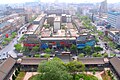
 People's Square in Yinchuan.
 -
 Phoenix Tablet fountain in Yinchuan.
 -
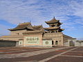 Tongxin Great Mosque, one of the oldest mosques in Ningxia and a famous cultural relic among the locals.
 -
 A tomb of the Western Xia


See also
[edit]Notes
[edit]- ^ /nɪŋˈʃɑː/,[5]/ˈnɪŋˈʃjɑː/;[6] 宁夏, Mandarin: [nǐŋ.ɕjâ]; alternately romanized as Ninghsia
References
[edit]Citations
[edit]- ^ a b "Administrative Divisions (2013)". Ningxia Statistical Yearbook 2014. Statistical Bureau of Ningxia. Archived from the original on 4 March 2016. Retrieved 19 December 2015.
- ^ "Communiqué of the Seventh National Population Census (No. 3)". National Bureau of Statistics of China. 11 May 2021. Retrieved 11 May 2021.
- ^ "National Data". China NBS. March 2024. Retrieved 22 June 2024. see also "zh: 2023年宁夏回族自治区国民经济和社会发展统计公报". ningxia.gov.cn. 29 April 2024. Retrieved 22 June 2024. The average exchange rate of 2023 was CNY 7.0467 to 1 USD dollar "Statistical communiqué of the People's Republic of China on the 2023 national economic and social development" (Press release). China NBS. 29 February 2024. Retrieved 22 June 2024.
- ^ "Human Development Indices (8.0)- China". Global Data Lab. Retrieved 23 September 2024.
- ^ "Ningxia". Lexico UK English Dictionary. Oxford University Press. Archived from the original on 18 May 2021.
- ^ "Ningxia". Dictionary.com Unabridged (Online). n.d.
- ^ "By Choosing Assimilation, China's Hui Have Become One of the World's Most Successful Muslim Minorities". The Economist. 8 October 2016. Retrieved 8 October 2016.
- ^ 宁夏回族自治区资源概况 [Overview of Resources in Ningxia Hui Autonomous Region]. Zhōngguó wǎng (in Chinese). 17 December 2009. Archived from the original on 4 August 2020. Retrieved 2 October 2018.
- ^ In China's Ningxia province, water shortage is so severe that the government is relocating people
- ^ a b Hsieh, Chiao-min; Falkenheim, Victor C. "Ningxia". Encyclopædia Britannica. Archived from the original on 27 October 2016.
- ^ Tobin, Meaghan (12 May 2019). "Can China Become the Wine World's Next California?". South China Morning Post.
- ^ "历史的眷顾:古城宁夏六宗"最"_宁夏民风民俗_新疆旅行网". www.xjlxw.com. Retrieved 1 September 2024.
- ^ a b Ho, Peter (2000). "The Myth of Desertification at China's Northwestern Frontier: The Case of Ningxia Province, 1929–1958". Modern China. 26 (3): 348–395. doi:10.1177/009770040002600304. S2CID 83080752.
- ^ Xu, Xin (2003). The Jews of Kaifeng: China History, Culture, and Religion. Jersey City, NJ: Ktav Publishing House.
- ^ Eiland, Murray L. (2003). "Carpets of the Ming Dynasty?". East and West. 53 (1/4): 179–208. ISSN 0012-8376. JSTOR 29757577.
- ^ Lin (2011), pp. 37–39.
- ^ China Archaeology and Art Digest, Volume 3, Issue 4. Art Text (HK). 2000. p. 354. Retrieved 28 November 2010.
- ^ "Dēng áobāo gēda shǎng juédǐng měijǐng" 登敖包疙瘩 赏绝顶美景. Fènghuáng zīxùn (in Chinese). 2 September 2014. Retrieved 6 November 2018.
- ^ Close, U.; McCormick (1922). "Where the Mountains Walked". National Geographic Magazine. Vol. 41, no. 5. pp. 445–464.
- ^ Feng, X.; Guo, A. (1985). "Earthquake Landslides in China". Proceedings, IVth International Conference and Field Workshop on Landslides. Tokyo: Japan Landslide Society. pp. 339–346.. (1985) "
- ^ Ningxia Bureau of Statistics, 2013, 1.2
- ^ a b c d e Ho, Peter (2016). "Empty Institutions, Non-Credibility and Pastoralism: China's Grazing Ban, Mining and Ethnicity". The Journal of Peasant Studies. 43 (6): 1145–1176. doi:10.1080/03066150.2016.1239617. S2CID 157632052.
- ^ Ho, Peter; Azadi, Hossein (2010). "Rangeland Degradation in North China: Perceptions of Pastoralists". Environmental Research. 110 (3): 302–307. Bibcode:2010ER....110..302H. doi:10.1016/j.envres.2009.12.007. PMID 20106474.
- ^ Ho, P. (2001). "Rangeland Degradation in North China Revisited? A Preliminary Statistical Analysis to Validate Non-Equilibrium Range Ecology". The Journal of Development Studies. 37 (3): 99–133. doi:10.1080/00220380412331321991. S2CID 154397243.
- ^ Ho, Peter (2003). "Mao's War against Nature? The Environmental Impact of the Grain-First Campaign in China". The China Journal. 50 (50): 37–59. doi:10.2307/3182245. JSTOR 3182245. S2CID 144410824.
- ^ Zhou, Z. 2013. A view of Ningxia ten years since the grazing ban [Jìn mù yī nián kàn Níngxià]. People's Daily, 29 June. p. 10.
- ^ "NASA Earth Observations Data Set Index". National Aeronautics and Space Administration. Archived from the original on 10 May 2020. Retrieved 30 January 2016.
- ^ "Níngxià kuàngchǎn zīyuán gàikuàng jí fēnbù" 宁夏矿产资源概况及分布 [Overview and Distribution of Mineral Resources in Ningxia]. Zhōngguó bǎikē wǎng (in Chinese). 16 March 2011. Archived from the original on 12 November 2014.
- ^ Lawrence, Susan; Martin, Michael (20 March 2013). "Understanding China's Political System" (PDF). Federation of American Scientists. Congressional Research Service. Archived (PDF) from the original on 8 January 2012. Retrieved 28 September 2019.
- ^ 党委书记权力究竟有多大? [How much power does a Party Secretary really have?]. 人民论坛 (in Chinese (China)). People's Daily Press. 23 January 2007. Archived from the original on 2 July 2018. Retrieved 29 April 2018.
- ^ "Zhōnghuá rénmín gònghéguó xiàn yǐshàng xíngzhèng qūhuà dàimǎ" 中华人民共和国县以上行政区划代码 [Code of Administrative Divisions Above the County Level of the People's Republic of China] (in Simplified Chinese) – via Ministry of Civil Affairs.
- ^ Shenzhen Bureau of Statistics. Shēnzhèn tǒngjì niánjiàn 2014 / 2014 Shenzhen Statistical Yearbook 深圳统计年鉴2014 (in Simplified Chinese and English). China Statistics Print. Archived from the original on 12 May 2015. Retrieved 29 May 2015.
- ^ Census Office of the State Council of the People's Republic of China; Population and Employment Statistics Division of the National Bureau of Statistics of the People's Republic of China (2012). Zhōngguó 2010 rénkǒu pǔchá fēn xiāng, zhèn, jiēdào zīliào 中国2010人口普查分乡、镇、街道资料 (1 ed.). Beijing: China Statistics Print. ISBN 978-7-5037-6660-2.
- ^ Zhonghua renmin gongheguo minzhengbu (2014). Zhōngguó mínzhèng tǒngjì niánjiàn 2014 中国民政统计年鉴2014 (in Simplified Chinese). Zhongguo tongji chuban she. ISBN 978-7-5037-7130-9.
- ^ 国务院人口普查办公室、国家统计局人口和社会科技统计司编 (2022). 中国2020年人口普查分县资料. Beijing: China Statistics Print. ISBN 978-7-5037-9772-9.
- ^ 国务院人口普查办公室、国家统计局人口和社会科技统计司编 (2012). 中国2010年人口普查分县资料. Beijing: China Statistics Print. ISBN 978-7-5037-6659-6.
- ^ Ningxia Bureau of Statistics 2013, 4.2
- ^ Ningxia Bureau of Statistics 2013, 11.20
- ^ "Ningxia dairies see success in quantity, quality". regional.chinadaily.com.cn. Retrieved 19 August 2024.
- ^ "Ningxia's dairies achieve high-quality development with smart factories, advanced breeding techniques". www.bastillepost.com. 16 July 2024. Retrieved 19 August 2024.
- ^ "Grape expansion: Chinese wine companies move west" Archived 31 July 2015 at the Wayback Machine, Want China Times, 15 December 2011. Retrieved 17 December 2011.
- ^ Phillips, Tom (14 June 2016). "China's Bordeaux: winemakers in 'gold rush' to turn desert into vineyards". The Guardian. Helan county, Ningxia province.
- ^ Lan, Xiaohuan (2024). How China Works: An Introduction to China's State-led Economic Development. Translated by Topp, Gary. Palgrave Macmillan. doi:10.1007/978-981-97-0080-6. ISBN 978-981-97-0079-0.
- ^ 欢迎访问银川经济技术开发区网站. Ycda.gov.cn. 24 April 2015. Retrieved 7 May 2015.
- ^ 1912年中国人口. Retrieved 6 March 2014.
- ^ 1928年中国人口. Retrieved 6 March 2014.
- ^ 1936–37年中国人口. Retrieved 6 March 2014.
- ^ 1947年全国人口. Retrieved 6 March 2014.
- ^ 中华人民共和国国家统计局关于一九八二年人口普查主要数字的公报. National Bureau of Statistics of China. Archived from the original on 10 May 2012.
- ^ 中华人民共和国国家统计局关于一九九〇年人口普查主要数据的公报. National Bureau of Statistics of China. Archived from the original on 19 June 2012.
- ^ 现将2000年第五次全国人口普查快速汇总的人口地区分布数据公布如下. National Bureau of Statistics of China. Archived from the original on 29 August 2012.
- ^ "Communiqué of the National Bureau of Statistics of People's Republic of China on Major Figures of the 2010 Population Census". National Bureau of Statistics of China. Archived from the original on 27 July 2013.
- ^ "Key Takeaways from China's 2020 Population Census". Reuters. 11 May 2021.
- ^ a b Min Junqing. The Present Situation and Characteristics of Contemporary Islam in China. JISMOR, 8. 2010 Islam by province, page 29. Data from: Yang Zongde, Study on Current Muslim Population in China, Jinan Muslim, 2, 2010.
- ^ a b China General Social Survey 2004. Report by: Wang, Xiuhua (2015). Explaining Christianity in China: Why a Foreign Religion has Taken Root in Unfertile Ground (PDF) (Master's thesis). Baylor University. p. 15. Archived from the original (PDF) on 25 September 2015.
- ^ "Níngxià měi 577 míng mùsīlín yǒngyǒu yīzuò qīngzhēnsì-sōuhú xīnwén" 宁夏每577名穆斯林拥有一座清真寺-搜狐新闻. news.sohu.com (in Chinese). 9 May 2008. Retrieved 11 January 2021.
- ^ "Guyuan Travel Guide: Map, Location, Climate, Attractions". travelchinaguide.com. Retrieved 29 January 2015.
Sources
[edit]- Lin, Hsiao-ting (2011). Modern China's Ethnic Frontiers: A Journey to the West. Abingdon-on-Thames: Routledge.
External links
[edit] Definitions from Wiktionary
 Media from Commons
 News from Wikinews
 Quotations from Wikiquote
 Texts from Wikisource
 Textbooks from Wikibooks
 Resources from Wikiversity
 Travel information from Wikivoyage
- Ningxia Provincial Government Archived 15 April 2012 at the Wayback Machine
- Ningxia at the Encyclopædia Britannica
- Economic profile for Ningxia at HKTDC
- Ningxia Profile – UNESCAP Archived 16 January 2014 at the Wayback Machine
- Ningxia Profile – China Economic Information Network
Places adjacent to Ningxia | ||||||||||||||||
|---|---|---|---|---|---|---|---|---|---|---|---|---|---|---|---|---|
| ||||||||||||||||
| National | |
|---|---|
| Geographic | |
| Other | |
Ningxia
View on GrokipediaHistory
Ancient and Imperial Periods
The region encompassing modern Ningxia exhibits evidence of Paleolithic human activity, particularly along the Yellow River, where the Shuidonggou site complex reveals tools and remains from the Initial Late Paleolithic period, indicating early adaptation to the arid environment through hunting and rudimentary settlement.[10] Archaeological discoveries in the Helan Mountains include over 20,000 petroglyphs carved into rocks, depicting hunting scenes, herding, battles, and symbolic motifs such as solar deities, reflecting the lifestyles of prehistoric and ancient nomadic groups who navigated resource scarcity in the steppe-desert interface.[11] These engravings, created using stone or metal tools, span from Neolithic times into the early historical era, underscoring persistent nomadic influences amid limited arable land dependent on Yellow River irrigation.[12] Early inhabitants included semi-nomadic groups like the Xirong and Qiang peoples, who occupied the northwestern frontiers and frequently clashed with expanding Chinese states over pastures and water sources, driven by the causal pressures of ecological constraints in the loess plateau and Gobi fringes.[13] The Tangut (Dangxiang), descendants of these Tibeto-Burman speaking nomads, rose to prominence, establishing the Western Xia Empire in 1038 under Emperor Li Yuanhao (Weiming Yuanhao), with its capital at Xingqing (modern Yinchuan).[14] This state, spanning Ningxia, parts of Gansu, and Shaanxi, promoted Buddhism as a state religion, translating numerous scriptures into the Tangut script and constructing grottoes and pagodas, while maintaining a military focused on cavalry to counter sedentary agrarian threats.[15] Western Xia engaged in protracted wars with the Northern Song Dynasty (960–1127), extracting tribute and territory, and later with the Jurchen Jin Dynasty (1115–1234), leveraging alliances and raids amid ongoing resource competitions.[16] The empire's downfall came in 1227 when Mongol forces under Genghis Khan besieged and annihilated it, integrating the Tangut lands into the nascent Mongol Empire.[14] Under the Mongol Yuan Dynasty (1271–1368), Ningxia was administered as part of Lingbei province, facilitating the incorporation of local Tangut elites into the imperial bureaucracy while exploiting the region's strategic position for overland trade and military logistics.[2] The subsequent Ming Dynasty (1368–1644) responded to renewed nomadic pressures from Mongol remnants by fortifying Ningxia with extensive Great Wall sections, including beacon towers and garrisons at passes like Sanguankou, to secure the Hexi Corridor against cavalry incursions and protect vital grain transport routes.[17] These defenses, built from rammed earth and stone, reflected empirical adaptations to the tactical advantages of mobile nomads in open terrain, often supplemented by irrigation canals tracing back to Qin times for sustaining frontier armies.[18] During the Qing Dynasty (1644–1912), similar fortifications were maintained and extended, with garrisons of Han Chinese and Manchu troops monitoring Oirat Mongol threats, though trade along northern Silk Road branches through Ningxia persisted, fostering exchanges of horses, furs, and Buddhist artifacts among multi-ethnic caravans from Central Asia.[19] This interplay of defense and commerce highlighted the region's role as a buffer zone, where scarcity of water and pasture perpetually shaped alliances and conflicts between sedentary and pastoral economies.[20]Republican and Early PRC Era
Following the collapse of the Qing dynasty in 1912, Ningxia entered a period of warlord domination characteristic of the Republican era's fragmentation, with Muslim generals asserting control over the northwest as part of a broader "Muslim belt" amid national instability.[21] The Hui warlord Ma Hongkui consolidated power as the province's paramount leader from the early 1930s, appointed governor in 1933 and retaining authority until 1949 through a combination of military prowess and administrative centralization that proved more stable than in many contemporaneous Chinese provinces.[22] His governance emphasized ethno-religious favoritism toward Hui Muslims, including suppression of non-compliant groups, while he led campaigns against communist forces encroaching from Shaanxi, such as skirmishes in the 1930s that secured Ningxia's borders but strained local resources.[23] [24] During the Second Sino-Japanese War (1937–1945), Ningxia's remote inland position insulated it from direct Japanese occupation, which primarily targeted coastal and eastern territories, allowing Ma Hongkui to prioritize anti-communist operations and loose alignment with the Nationalist government without significant foreign incursions disrupting provincial administration.[25] By 1949, as communist armies advanced in the Chinese Civil War, Ma Hongkui evacuated to Hong Kong via air on September 17, leaving his son Ma Dunjing to briefly manage a losing defense before the People's Liberation Army fully incorporated Ningxia by October.[26] In the early People's Republic of China (PRC) period, land reform initiatives from 1950 to 1953 systematically redistributed arable land from designated landlords and former warlord associates to peasant households, aiming to dismantle feudal structures in Ningxia's predominantly agrarian and pastoral economy, though implementation faced challenges from the region's ethnic diversity and arid terrain.[27] Administrative restructuring in 1954 merged Ningxia into Gansu Province to streamline governance, but ethnic identification campaigns in the 1950s—documenting Hui populations exceeding 6% in key areas—prompted its separation.[28] On October 25, 1958, the Ningxia Hui Autonomous Region was formally established, granting nominal self-governance to the Hui minority while integrating it into the PRC's centralized socialist framework.[29] The Great Leap Forward, launched concurrently in 1958, enforced rapid collectivization and communal labor in Ningxia, diverting agricultural workers to unproven industrial efforts like backyard steel furnaces and inflated grain procurement quotas that disregarded local semi-arid conditions, resulting in sharp declines in food output and widespread shortages from 1959 to 1961.[30] These policies contributed to the national famine's toll—estimated at 30 million excess deaths overall—through mechanisms such as falsified harvest reports and export of grain despite domestic deficits, with Ningxia's vulnerability amplified by its reliance on Yellow River irrigation and limited cultivable land comprising under 20% of its territory.[31] Recovery began post-1961 as policies moderated, but the era underscored tensions between ideological drives and regional ecological constraints.[32]Establishment of Autonomy and Post-1949 Developments
Following the establishment of the People's Republic of China in 1949, the central government conducted ethnic identification campaigns in the early 1950s, officially recognizing the Hui as a distinct ethnic group in 1954 by classifying various Muslim communities—previously diverse in origin and practice—under this unified category based on shared Islamic faith and cultural traits rather than strict linguistic or territorial criteria.[33] This process, involving party cadres and ethnographers dispatched to regions like Ningxia, aimed to standardize minority classifications for administrative purposes but often bundled heterogeneous groups, prioritizing political utility over anthropological precision.[34] Ningxia, previously merged into Gansu Province in 1954, was separated and reconstituted as the Ningxia Hui Autonomous Region on October 25, 1958, encompassing Hui-majority areas along the Yellow River valley to grant nominal self-governance in cultural, educational, and local economic matters, though all policies remained subject to oversight by the Chinese Communist Party's central apparatus.[35] In the Maoist era, state-led infrastructure initiatives focused on harnessing the Yellow River for irrigation, with projects in the late 1950s and 1960s expanding canal networks and reclaiming desert fringes, thereby increasing arable land from approximately 10% of the region's total area in the early 1950s to over 15% by the mid-1960s through systematic water diversion and soil improvement efforts.[22] These developments, part of broader collectivization drives, prioritized grain production and flood control but were disrupted by campaigns like the Great Leap Forward (1958–1962), which imposed unrealistic quotas and diverted labor, leading to localized famines and setbacks in agricultural output despite infrastructural gains.[36] The Cultural Revolution (1966–1976) severely curtailed religious expression in Ningxia, where Red Guards targeted Islamic institutions: imams were persecuted, Qurans confiscated, and numerous mosques defaced, closed, or demolished, reflecting the campaign's nationwide assault on "feudal" practices and eroding Hui cultural autonomy under the guise of ideological purification.[37] Following Mao's death in 1976, Deng Xiaoping's reform policies from 1978 onward relaxed controls, permitting the reopening of mosques and resumption of limited religious activities in the region, while introducing household responsibility systems that devolved some agricultural decision-making from communes to families, though ethnic autonomy frameworks continued to emphasize Han-dominated Party leadership over substantive self-rule.[38]Recent Economic and Ecological Reforms (2000s–Present)
In the Hu Jintao-Wen Jiabao administration (2002–2012), Ningxia benefited from national poverty alleviation programs emphasizing rural development and the extension of the dibao social assistance system to impoverished areas, which helped reduce dependency on agriculture amid desertification pressures.[39] These efforts laid groundwork for targeted interventions in ethnic minority regions like Ningxia, where subsidies supported infrastructure and shifted some rural populations toward non-farm employment, though outcomes relied heavily on central fiscal transfers rather than self-sustaining growth.[40] Under Xi Jinping's leadership from the 2010s onward, Ningxia pursued high-quality economic development integrated with ecological protection, including deepening reforms in coal chemicals, new materials, and digital sectors as part of Yellow River Basin initiatives.[41] The region's GDP grew 5.8% year-on-year in the first quarter of 2024, outperforming national averages, with 2025 targets set at 5.5% growth and emphasis on green energy overhauls.[42][43] Key projects include expansions in the Tengger Desert, where a 1 GW solar facility came online by 2025 as part of broader desert-based renewable deployments generating gigawatt-scale power, combining land restoration with energy production.[44][45] Ecological reforms advanced through intensified participation in the Three-North Shelterbelt Program, which since the 2000s has expanded afforestation and photovoltaic integration to combat desertification, with sites like Baijitan demonstrating reduced sand encroachment via technology-driven planting.[46][47] However, these gains face sustainability challenges from acute water scarcity, where agricultural and industrial demands exacerbate shortages, amplifying pollution effects and questioning long-term viability without diversified water management beyond subsidies.[48][49] Official metrics highlight progress in meeting environmental benchmarks, yet causal factors like over-reliance on Yellow River irrigation underscore risks of ecological rebound if economic incentives prioritize output over conservation.[50]Geography and Environment
Location and Topography
Ningxia Hui Autonomous Region occupies a position in north-central China, spanning approximately 66,400 square kilometers along the upper and middle reaches of the Yellow River.[51] The region lies between latitudes 35° and 39° N and longitudes 104° and 107° E, bordering Inner Mongolia Autonomous Region to the north, Shaanxi Province to the east, and Gansu Province to the south and west.[52] This inland location within the Loess Plateau transition zone shapes its role as a corridor between the arid northwest and more fertile central plains, historically channeling migration and trade along the river valley.[53] The topography of Ningxia features diverse terrain divided by the Yellow River, which flows northward through the region, creating an alluvial plain that supports concentrated human settlement. To the west rise the Helan Mountains, forming a natural barrier with elevations up to 3,556 meters at their peak, while the southern portion includes the Liupan Mountains, exceeding 2,900 meters, and central low hills.[54] Northern areas extend into the fringes of the Tengger Desert and the broader Ordos Loop, characterized by steppe and desert landscapes comprising over half the territory.[55] Arable land is restricted to roughly the river basins and irrigated zones, accounting for a minority of the surface area and dictating linear settlement patterns along these fertile strips amid predominantly non-arable highlands and sands.[56] Elevations across Ningxia generally range from 1,000 to 2,000 meters above sea level, with an average around 1,565 meters, contributing to varied micro-terrains but also exposing the region to seismic hazards from active Quaternary faults.[57] Major fault systems, including the Haiyuan Fault and the eastern Liupan Mountain Fault in the south, have historically generated destructive earthquakes, such as the 1920 Haiyuan event, influencing infrastructure design and population distribution away from high-risk rift zones.[58] These geological features underscore the causal link between topography and settlement, favoring valley floors for agriculture while limiting expansion into rugged or unstable uplands.[59]Climate and Desertification Challenges
Ningxia possesses a semi-arid continental climate, with annual precipitation varying from 150 mm in the arid northern plains to 600 mm in the southern mountainous areas, averaging around 300 mm region-wide.[60] Mean monthly temperatures range from -9°C in January to 24°C in July, accompanied by extremes of -30°C in winter and 39°C in summer, reflecting significant diurnal and seasonal fluctuations.[61] Spring dust storms, driven by strong winds from the adjacent Gobi and Tengger Deserts, frequently transport sand and dust across the region, intensifying erosion and reducing visibility.[56] Desertification afflicted roughly 24% of Ningxia's 66,400 km² land area by the late 1990s, concentrated in central and northern zones where wind erosion and low vegetation cover predominated.[56] These conditions stemmed from climatic aridity compounded by human factors such as overgrazing and improper land use, leading to sand encroachment that threatened arable land and affected over 3 million residents through dust pollution and productivity losses.[50] To combat desertification, initiatives like wind-sand fixation and afforestation under the Three-North Shelterbelt Program have implemented straw checkerboards, shrub planting, and grazing exclusions, yielding empirical gains in vegetation stability.[62] In areas such as the Baijitan Nature Reserve, fractional vegetation coverage increased substantially from 2000 to 2019, correlating with diminished wind speeds and sand transport near the surface.[63] Grassland coverage has risen by approximately 0.25% annually since 2001, per remote sensing analyses, aiding soil retention and reducing erosion rates.[64] However, project efficacy remains contested, with tree survival rates often 40-60% due to harsh conditions, and some studies noting persistent localized degradation from unsustainable practices despite overall vegetation upticks.[65][66]Hydrology and Natural Resources
The Yellow River constitutes the principal surface water source for Ningxia, channeling vital supplies through its middle reaches to sustain irrigation across arid landscapes. This river supports an irrigation area of approximately 552,000 hectares via an extensive network of 25 trunk canals, enabling agricultural productivity in a region otherwise constrained by limited precipitation.[67] The Yellow River-dependent irrigation encompasses roughly 75% of the total agricultural irrigated land, underscoring its causal dominance in water availability for farming.[48] Groundwater extraction supplements surface supplies but has led to overexploitation challenges, with five designated overexploited zones spanning 741 km² reported in 2017, reflecting strains from intensive agricultural and industrial demands.[68] To mitigate such issues, Ningxia has pursued water conservation, achieving national water-saving city standards in all prefecture-level cities by the end of 2023, through measures like improved irrigation efficiency and quota systems.[69] Ningxia harbors significant mineral endowments, prominently featuring proven coal reserves exceeding 30 billion tons, concentrated in areas like Ningdong, which bolsters the region's energy base.[70] Natural gas resources, including coalbed methane associated with coal seams, and gypsum deposits further diversify extractable assets, though rare earth elements remain minor in scale relative to national outputs. The territory also exhibits strong renewable potential, with annual solar radiation surpassing 1,600 kWh/m² and favorable wind regimes supporting power generation exceeding typical northern Chinese averages.[71]Government and Politics
Administrative Governance
Ningxia Hui Autonomous Region functions as a provincial-level administrative division under the direct oversight of the State Council, integrating into China's centralized governance framework while adhering to the dual party-state system. The Chinese Communist Party (CCP) exerts dominant influence, with its regional committee steering all major decisions through ideological, organizational, and personnel controls. The CCP Ningxia Hui Autonomous Regional Committee Secretary holds the highest authority, outranking the chairman of the People's Government and effectively directing executive actions. Li Yifei assumed this role on June 28, 2024, succeeding Liang Yanshun. This position enables veto power over government proposals and ensures alignment with central CCP directives. The Regional People's Congress and its Standing Committee nominally handle legislative functions, such as electing the government chairman and approving budgets, but these bodies convene periodically under party supervision and lack independent initiative. The autonomous region's administration encompasses five prefecture-level units, where local party committees mirror the hierarchical CCP dominance. Representation in congresses includes designated quotas to reflect demographic composition. Ningxia's budget relies substantially on fiscal transfer payments from the central government, which cover a major share of expenditures amid limited local revenue generation. During the 2025 National People's Congress sessions, the Ningxia delegation, chaired by Party Secretary Li Yifei, focused deliberations on the government work report, emphasizing sustained economic expansion and aligned development initiatives.Ethnic Autonomy Framework
The Ningxia Hui Autonomous Region was established on October 25, 1958, as part of China's regional ethnic autonomy system formalized in the 1954 Constitution, granting self-governing rights to areas with significant minority populations to manage local affairs while adhering to national laws.[72][73] This framework aimed to integrate ethnic minorities like the Hui, who constitute approximately 36% of Ningxia's population, into the socialist state through dedicated administrative structures, including autonomous legislative powers over economic, cultural, and educational matters tailored to minority needs.[74] Implementation in the 1950s and 1960s involved establishing Hui-led cadres and councils, with policies emphasizing land redistribution and infrastructure development to address historical inequalities, though centralized oversight from Beijing limited full devolution of authority.[75] Preferential policies under the autonomy model included affirmative action measures such as lower university admission thresholds for Hui students, tax exemptions or reductions for minority enterprises, and quotas in civil service hiring to promote representation and socioeconomic upliftment.[76] These provisions, rooted in the 1984 Regional Ethnic Autonomy Law, extended to family planning relaxations and subsidies, ostensibly fostering loyalty and development but often critiqued for reinforcing dependency rather than genuine empowerment, as evidenced by persistent income gaps despite targeted aid.[77] By the 2000s, such policies had scaled to cover education access, where Hui applicants received score deductions of up to 20 points on national exams, contributing to higher minority enrollment rates but raising questions about merit dilution in competitive sectors.[78] Under Xi Jinping's leadership since 2012, the autonomy framework has undergone contractions prioritizing national unity over ethnic distinctiveness, aligning with the "Chinese Dream" of collective rejuvenation that subsumes minority identities into a unified Zhonghua minzu (Chinese nation).[79] Reforms from 2017 onward, including the 2018 revisions to ethnic affairs regulations, scaled back affirmative action by standardizing admission criteria and phasing out tax privileges deemed divisive, with Ningxia authorities citing enhanced social cohesion and economic efficiency as outcomes.[76] This shift parallels policies in Inner Mongolia, where bilingual education mandates were curtailed in 2020 to emphasize Mandarin proficiency, similarly applied in Ningxia through curriculum reforms promoting "ethnic fusion" and ideological alignment.[80] Official assessments highlight stability gains, such as reduced inter-ethnic tensions and integrated development projects, while independent analyses argue these changes erode autonomy by centralizing control, potentially undermining long-term minority incentives for participation in national goals.[81][82]Religious Policies and Human Rights Concerns
The Chinese government officially recognizes Islam as one of five permitted religions, requiring Muslim organizations to register with state-sanctioned patriotic associations that enforce alignment with socialist principles and national security priorities.[83] In Ningxia Hui Autonomous Region, where Hui Muslims constitute approximately 35 percent of the population, religious policies emphasize "Sinicization," a campaign intensified since 2017 under President Xi Jinping to adapt Islamic practices to Chinese cultural norms, including the removal of architectural features deemed foreign, such as domes and minarets, and the elimination of Arabic script from public spaces.[84][85] This has involved the demolition or alteration of numerous mosques, with authorities citing "illegal construction" as justification; for instance, in August 2018, hundreds of Hui Muslims in Ningxia protested the planned demolition of a historic mosque in Yinchuan, leading to a temporary standoff resolved only after officials promised minimal changes but proceeded with removals of Islamic icons and Arabic signage.[86][87][88] Following the expansion of security measures in Xinjiang, similar restrictions spread to Hui areas in Ningxia by 2019, including bans on public displays of Arabic script—even on halal certifications and restaurant signs—and the removal of the term "halal" from official provincial seals to curb perceived "Arabization."[89][9] These actions, framed by Beijing as preventing extremism and promoting national unity, prompted local Hui communities to express fears of replicating Xinjiang's mass internment model, with reports of increased surveillance, restrictions on religious education for minors, and closures of unregistered mosques.[9][90] After Xi Jinping's 2020 visit to Ningxia, where he criticized insufficient curbs on Islamic influences, provincial authorities accelerated Sinicization efforts, including further mosque modifications and purges of religious symbols from public and commercial spaces.[90] International observers, including the U.S. Commission on International Religious Freedom (USCIRF), have documented these policies as contributing to systemic repression, with the 2025 USCIRF Annual Report highlighting ongoing surveillance, forced assimilation, and human rights violations against Muslims in China, recommending designation of the country as a "Country of Particular Concern."[91] Human Rights Watch reported in 2023 that authorities in Ningxia and other Hui regions shuttered or razed mosques, altering an estimated significant portion of structures to conform to state-approved designs, amid broader efforts to eliminate perceived foreign influences.[87] While official claims assert these measures enhance social stability and counter separatism—echoing rhetoric used in Xinjiang—critics argue they erode religious autonomy, with parallels in youth indoctrination bans and cultural erasure tactics, though Ningxia has seen fewer documented mass detentions compared to Uyghur regions.[91][9]Administrative Divisions
Prefecture-Level Cities and Leagues
Ningxia Hui Autonomous Region comprises five prefecture-level cities: Yinchuan, the capital and largest city; Shizuishan in the north; Wuzhong in the central-south; Guyuan in the south; and Zhongwei in the west.[35][92] The region does not include any leagues or banners, administrative units typically found in Mongol-influenced areas like Inner Mongolia.[93] These prefecture-level cities oversee 22 county-level divisions: nine districts, eleven counties, and two county-level cities.[7] In the 2020 national census, Ningxia recorded a total permanent population of 7,202,654 across these divisions, with an urbanization rate of approximately 60 percent.| Prefecture-level City | Population (2020 Census) |
|---|---|
| Yinchuan | 2,859,074 |
| Wuzhong | 1,382,713 |
| Shizuishan | 721,505 |
| Zhongwei | 489,708 |
| Guyuan | 472,202 |
Key Urban and Rural Districts
Yinchuan, the capital and largest urban center of Ningxia, encompasses key districts such as Xingqing and Jinfeng, which form the core of the region's metropolitan area with a prefecture-level population of 2,859,074 as of the 2020 census, up from 1,993,088 in 2010, driven by migration and economic opportunities in services and manufacturing.[95] This growth highlights the concentration of urban development in the northern Yellow River plain, where districts benefit from relatively fertile irrigated lands supporting higher population densities compared to southern regions. Zhongwei represents a distinctive urban-rural interface, with its 1,067,336 residents in 2020 integrating coastal desert ecosystems and oasis agriculture; districts like Shapotou feature the convergence of the Tengger Desert and Yellow River, fostering tourism and specialized farming such as goji berry cultivation amid arid conditions.[96][97] Rural townships here depend on canal systems diverting Yellow River water, with agriculture consuming over 90% of local water resources to sustain crops in otherwise desert-prone areas.[98] In contrast, rural districts in southern Ningxia, such as those in Guyuan prefecture with 1,142,000 residents in 2020, exhibit mountainous loess plateau terrain suited to dryland farming of potatoes and grains, with limited irrigation reliance and higher vulnerability to soil erosion and drought, underscoring disparities in rural productivity between northern irrigated plains and southern highlands.[99] Ningxia's overall urbanization rate advanced from 47.96% in 2010 to 59.86% by 2019, amplifying urban-rural divides as populations shifted toward prefectural centers like Yinchuan and Wuzhong.[100]| Prefecture-Level City | 2010 Population | 2020 Population |
|---|---|---|
| Yinchuan | 1,993,088 | 2,859,074 |
| Zhongwei | 1,080,832 | 1,067,336 |