
Community hub
Poole
View on Wikipedia
Poole (/puːl/ ⓘ) is a coastal town and seaport on the south coast of England in the Bournemouth, Christchurch and Poole unitary authority area in Dorset, England. The town is 21 miles (34 km) east of Dorchester and adjoins Bournemouth to the east. Since 1 April 2019, the local authority is Bournemouth, Christchurch and Poole Council. The town had an estimated population of 151,500 (mid-2016 census estimates) making it the second-largest town in the ceremonial county of Dorset. Together with Bournemouth and Christchurch, the conurbation has a total population of nearly 400,000.
Key Information


.jpg)


.svg)

The settlement dates back to before the Iron Age. The earliest recorded use of the town's name was in the 12th century when the town began to emerge as an important port, prospering with the introduction of the wool trade. Later, the town had important trade links with North America and, at its peak during the 18th century, it was one of the busiest ports in Britain. In the Second World War, Poole was one of the main departing points for the Normandy landings.
Poole is a tourist resort, attracting visitors with its large natural harbour, history, the Lighthouse arts centre and Blue Flag beaches. The town has a commercial port with cross-Channel freight and passenger ferry services, which connect with the Channel Islands of Jersey and Guernsey, as well as the French port town of Saint-Malo, Brittany.
The headquarters of the Royal National Lifeboat Institution (RNLI) is in Poole, and the Royal Marines have a base in the town's harbour. Despite their names, Poole is the home of The Arts University Bournemouth, the Bournemouth Symphony Orchestra and a significant part of Bournemouth University.
History
[edit]
The area around modern Poole has been inhabited for at least the past 2,500 years, with nearby Christchurch Harbour evidencing human activity dating back to the Neolithic period at Hengistbury Head. During the 3rd century BC, Celtic-speaking people known as the Durotriges moved from hilltop settlements at Maiden Castle and Badbury Rings to heathland around the River Frome and Poole Harbour.[2] The Romans landed at Poole during their conquest of Britain in the 1st century and took over an Iron Age settlement at Hamworthy, an area just west of the modern town centre.[3] This was used as a supply base for the fortress at Lake Farm, Ashington and a settlement at Vindocladia (Bradbury Rings).[4]
The town's name may have originated around the post-Roman or Anglo-Saxon periods, and seems to have originally applied to the harbour. It is derived from the late Brittonic or early Old English words pol meaning a pool or creek.[5]
By the middle to late Anglo-Saxon period, Poole was included in the Kingdom of Wessex. The settlement was used as a base for fishing and the harbour a place for ships to anchor on their way to the River Frome and the important Anglo-Saxon town of Wareham.[6] Poole experienced two large-scale Viking invasions during this era: in 876, Guthrum sailed his fleet through the harbour to attack Wareham, and in 1015, Canute began his conquest of England in Poole Harbour, using it as a base to raid and pillage Wessex.[7][8]
Following the Norman conquest of England, Poole rapidly grew into a busy port as the importance of Wareham declined.[9] The town was part of the manor of Canford but does not exist as an identifiable entry in the Domesday Book.[10] The earliest written mention of Poole occurred on a document from 1196 describing the newly built St James's Chapel in "La Pole".[11] The Lord of the Manor, Sir William Longspée, sold a charter of liberties to the burgesses of Poole in 1248 to raise funds for his participation in the Seventh Crusade.[6] Consequently, Poole gained a small measure of freedom from feudal rule and acquired the right to appoint a mayor and hold a court within the town. Poole's growing importance was recognised in 1433 when it was awarded staple port status by King Henry VI, enabling the port to begin exporting wool and in turn granting a licence for the construction of a town wall.[12] In 1568, Poole gained further autonomy when it was granted legal independence from Dorset and made a county corporate by the Great Charter of Elizabeth I.[13] During the English Civil War, Poole's puritan stance and its merchants' opposition to the ship money tax introduced by King Charles I led to the town declaring for Parliament.[14] Poole escaped any large-scale attack and with the Royalists on the brink of defeat in 1646, the Parliamentary garrison from Poole laid siege to and captured the nearby Royalist stronghold at Corfe Castle.[15][16]

Poole established successful commerce with the North American colonies in the 16th century, including the important fisheries of Newfoundland.[13] Trade with Newfoundland grew steadily to meet the demand for fish from the Catholic countries of Europe. Poole's share of this trade varied but the most prosperous period started in the early 18th century and lasted until the early 19th century. The trade followed a three-cornered route; ships sailed to Newfoundland with salt and provisions, then carried dried and salted fish to Europe before returning to Poole with wine, olive oil, and salt.[17] By the early 18th century, Poole had more ships trading with North America than any other English port and vast wealth was brought to Poole's merchants.[18] This prosperity supported much of the development which now characterises the Old Town where many of the medieval buildings were replaced with Georgian mansions and terraced housing.[17][19] The end of the Napoleonic Wars and the conclusion of the War of 1812 ended Britain's monopoly over the Newfoundland fisheries and other nations took over services provided by Poole's merchants at a lower cost. Poole's Newfoundland trade rapidly declined and within a decade most merchants had ceased trading.[20][21]

The town grew rapidly during the Industrial Revolution as urbanisation took place and the town became an area of mercantile prosperity and overcrowded poverty. At the turn of the 19th century, nine out of ten workers were engaged in harbour activities. On 1 January 1848 the port had 116 registered vessels (13,641 tons) of its own[22] but as the century progressed, ships became too large for the shallow harbour and the port lost business to the deepwater ports at Liverpool, Southampton and Plymouth.[18] Poole's first railway station opened in Hamworthy in 1847 and later extended to the centre of Poole in 1872, effectively ending the port's busy coastal shipping trade.[21] The beaches and landscape of southern Dorset and south-west Hampshire began to attract tourists during the 19th century and the villages to the east of Poole began to grow and merge until the seaside resort of Bournemouth emerged. Although Poole did not become a resort, like many of its neighbours, it continued to prosper as the rapid expansion of Bournemouth created a large demand for goods manufactured in Poole.[23]
During World War II, Poole was the third-largest embarkation point for D-Day landings of Operation Overlord and afterwards served as a base for supplies to the allied forces in Europe.[13] Eighty-one landing craft containing American troops from the 29th Infantry Division and the US Army Rangers departed Poole Harbour for Omaha Beach.[24] Poole was also an important centre for the development of Combined Operations and the base for a US Coast Guard rescue flotilla of 60 cutters.[25] Much of the town suffered from German bombing during the war - in which the Municipal Borough lost 75 civilian lives[26] - and years of neglect in the post-war economic decline. Major redevelopment projects began in the 1950s and 1960s and large areas of slum properties were demolished and replaced with modern public housing and facilities. Many of Poole's historic buildings were demolished during this period, particularly in the Old Town area of Poole. Consequently, a 6-hectare (15-acre) Conservation Area was created in the town centre in 1975 to preserve Poole's most notable buildings.[27][28] The Poole explosion of 1988 caused 3,500 people to be evacuated out of the town centre in the biggest peacetime evacuation the country had seen since the World War II.[29][30]
Governance
[edit]There is one tier of local government covering Poole, at unitary authority level: Bournemouth, Christchurch and Poole Council, which is based at the Civic Centre in Bournemouth.
Administrative history
[edit].jpg)
Poole was an ancient borough, which lay within the ancient parish of Canford Magna. The borough acquired its first charter in 1248 from William Longespée, who was lord of the manor.[31][32] A chapel of ease dedicated to St James existed at Poole from at least 1142.[33] In 1538, the borough was removed from the parish of Canford Magna to become its own parish, called Poole St James.[34]
In 1568, Poole was given the right to appoint its own sheriff, making it a county corporate, independent from the jurisdiction of the Sheriff of Dorset.[32]
In 1836, Poole was reformed to become a municipal borough. As part of that reform, the borough boundaries were enlarged to take in Hamworthy, Longfleet and Parkstone.[a][36]

When elected county councils were established in 1889, despite being a county corporate, Poole was not considered large enough for the borough council to take on county council functions.[b] It was therefore included in the administrative county of Dorset under the new Dorset County Council. The borough boundaries were enlarged in 1905 to take in Branksome, and again in 1931 to absorb Canford Magna.[38] In 1932 the borough council built itself Poole Civic Centre on Parkstone Road to serve as its headquarters.[39]
The borough of Poole was reconstituted as a non-metropolitan district in 1974 under the Local Government Act 1972. The district kept the same boundaries and its borough status, but there were some changes to the council's responsibilities.[40][41]
In 1997, Poole Borough Council became a unitary authority, taking over the provision of county council functions from Dorset County Council.[42]
The borough of Poole was abolished in 2019, merging with the boroughs of Bournemouth and Christchurch to become a new local government district called Bournemouth, Christchurch and Poole, the council of which is a unitary authority.[43] The Bournemouth, Christchurch and Poole district remains part of the ceremonial county of Dorset for the purposes of lieutenancy.[44]
Since the abolition of Poole Borough Council in 2019, Poole has had charter trustees, being the Bournemouth, Christchurch and Poole councillors representing wards in the former borough of Poole. The trustees preserve the town's civic charters and traditions, including appointing one of their number each year to serve as mayor and another to serve as sheriff; these roles are now purely honorary with no practical functions.[45] Poole is one of only fifteen towns and cities across England and Wales which appoint their own sheriff, with Poole's right to do so stemming from its former status as a county corporate.[46]
Parliamentary representation
[edit]Poole is represented by three parliamentary constituencies in the House of Commons; Poole, Mid Dorset and North Poole, and Bournemouth West. The borough constituency of Poole has existed since 1950. Previously the town had been a parliamentary borough, electing two members of parliament from 1455 until 1865 when representation was reduced to one member. In 1885 the constituency was abolished altogether and absorbed into the East Dorset constituency until its reintroduction in 1950.
Coat of arms
[edit]
The design of the coat of arms originated in a seal from the late 14th century and were recorded by Clarenceux King of Arms during the heraldic visitation of Dorset in 1563.[47] The wavy bars of black and gold represent the sea and the dolphin is a sign of Poole's maritime interests.[48] The scallop shells are the emblem of Saint James and are associated with his shrine at Santiago de Compostela – a popular destination for Christian pilgrims departing from Poole Harbour in the Middle Ages.[48]
The arms were confirmed by the College of Arms on 19 June 1948, and at the same time, the crest (a mermaid supporting an anchor and holding a cannonball) was granted. Following local government reorganisation in 1974, the 1948 arms were transferred to Poole Borough Council. In 1976, the council received the grant of supporters for the coat of arms. The supporters refer to important charters given to the town; to the left is a gold lion holding a long sword representing William Longespee who in 1248 granted the town's first charter; on the right is a dragon derived from the Royal Arms of Elizabeth I who granted Poole county corporate status in 1568. The Latin motto – Ad Morem Villae De Poole, means: According to the Custom of the Town of Poole, and derives from the Great Charter of 1568.[48]
Geography
[edit]Poole is a complex shore of the English Channel; it lies on the northern and eastern edges of Poole Harbour, 97 miles (156 km) west-southwest of London.[49] The oldest part of the town (including the historic Old Town, Poole Quay and the Dolphin Shopping Centre) lies to the south-east of Holes Bay on a peninsula jutting into the harbour, although much of the land to the east of the peninsula has been reclaimed from the harbour since the mid-20th century. To the west is Upton and Corfe Mullen and across the northern border at the River Stour lies Wimborne Minster. At the eastern edge of Poole, the town abuts Bournemouth and the settlements of Kinson, Winton and Westbourne. To the south of Poole along the coast lies Poole Bay, which has 3 miles (4.8 km) of sandy beaches from Sandbanks in the west to Bournemouth in the east.
Urban areas and districts of the town
Poole is made up of numerous suburbs and neighbourhoods, many of which developed from villages or hamlets that were absorbed into Poole as the town grew.
Alderney – Bearwood – Branksome – Branksome Park – Broadstone – Canford Cliffs – Canford Heath – Creekmoor – Fleetsbridge – Hamworthy – Lilliput – Longfleet – Merley – Oakley – Newtown – Oakdale – Parkstone – Penn Hill – Sandbanks – Sterte – Talbot Village – Wallisdown – Waterloo – Whitecliff

The natural environment of Poole is characterised by lowland heathland to the north and wooded chines and coastline to the south. The heathland habitat supports the six native British reptile species and provides a home for a range of dragonflies and rare birds. Development has destroyed much of the heath but scattered fragments remain to the north of Poole and have been designated Special Protection Areas.[citation needed] The town lies on unresistant beds of Eocene clays (mainly London Clay and Gault Clay), sands and gravels.[50] The River Frome runs through this weak rock, and its many tributaries have carved out a wide estuary. At the mouth of the estuary sand spits have been deposited, enclosing the estuary to create Poole Harbour.[51]
The harbour is the largest natural harbour in Europe and the second-largest natural harbour in the world after Sydney Harbour.[52] It is an area of international importance for nature conservation and is noted for its ecology, supporting salt marshes, mudflats and an internationally important habitat for several species of migrating bird. It has been designated a Site of Special Scientific Interest (SSSI), a Special Protection Area and a Ramsar site as well as falling within the Dorset National Landscape area.[53] The harbour covers an area of 15 square miles (11 sq nmi; 39 km2) and is extremely shallow. The main shipping channels are 7.5 metres (25 ft) deep the average depth of the harbour is 48 centimetres (1 ft 7 in).[54][55] It contains several small islands, the largest is Brownsea Island, a nature reserve owned by the National Trust and the birthplace of the Scouting movement and location of the first Scout Camp.[56] Britain's largest onshore oil field operates from Wytch Farm on the south shore of the harbour.[57] The oil reservoirs extend under the harbour and eastwards from Sandbanks and Studland for 6.2 miles (10 km) under the sea to the south of Bournemouth.[58]
Situated directly to the east of the Jurassic Coast, Poole is a gateway town to the UNESCO World Heritage Site, which includes 95 miles (153 km) of the Dorset and east Devon coast important for its geology, landforms and rich fossil record.[59] The South West Coast Path stretches for 630 miles (1,010 km) from Minehead in Somerset, along the coast of Devon and Cornwall and on to Poole. The path is England's longest national trail.[60]

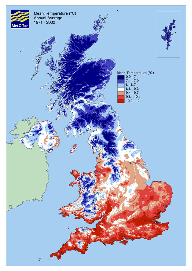
Climate
[edit]Due to its location on the south coast of England, Poole has a temperate climate with a small variation in daily and annual temperatures. The average annual mean temperature from 1971 to 2000 was 10.2–12 °C (50.4–53.6 °F).[61] The warmest months in Poole are July and August, which have an average temperature range of 12 to 22 °C (54 to 72 °F), and the coolest months are January and February, which have a range of 2 to 8.3 °C (35.6 to 46.9 °F).[62] Mean sea surface temperatures range from 6.9 °C (44.4 °F) in February to 18.5 °C (65.3 °F) in August.[63] The average annual rainfall of 592.6 millimetres (23.33 in) is well below the UK average of 1,126 millimetres (44.3 in).[64]
| Climate data for Poole, Dorset, England | |||||||||||||
|---|---|---|---|---|---|---|---|---|---|---|---|---|---|
| Month | Jan | Feb | Mar | Apr | May | Jun | Jul | Aug | Sep | Oct | Nov | Dec | Year |
| Mean daily maximum °C (°F) | 8 (46) |
8 (46) |
11 (52) |
13 (55) |
17 (63) |
19 (66) |
22 (72) |
22 (72) |
19 (66) |
15 (59) |
11 (52) |
9 (48) |
14.5 (58.1) |
| Mean daily minimum °C (°F) | 2 (36) |
2 (36) |
3 (37) |
4 (39) |
7 (45) |
10 (50) |
12 (54) |
12 (54) |
10 (50) |
7 (45) |
4 (39) |
3 (37) |
6.3 (43.3) |
| Average precipitation mm (inches) | 62.9 (2.48) |
50.3 (1.98) |
40.7 (1.60) |
45.5 (1.79) |
29.2 (1.15) |
35.6 (1.40) |
31.8 (1.25) |
35.5 (1.40) |
51.5 (2.03) |
73.5 (2.89) |
69.0 (2.72) |
67.2 (2.65) |
592.6 (23.33) |
| Source: MSN[62] | |||||||||||||
Green belt
[edit]Poole lies at the centre of a green belt region that extends into the wider surrounding counties. It is in place to reduce urban sprawl, prevent the towns in the South East Dorset conurbation from further convergence, protect the identity of outlying communities, and preserve nearby countryside. This is achieved by restricting inappropriate development within the designated areas and imposing stricter conditions on permitted building.[65]
Poole has areas of green belt to the north and west of the district, mostly on the fringes of the shared border with the Purbeck and East Dorset districts. These cover landscape features and greenfield facilities including the rivers Stour and Sherford and their floodplains, the Stour Valley Way, Canford Heathland, Dunyeats Hill and Corfe and Barrow Hill nature reserves, Upton Country Park, Pergins Island, and the Wimborne District Society of Model Engineers miniature railway.
The small communities at Merley, Canford Magna, Oakley and Oakley Hill are separated from the main urban area, and while inset, are not covered by green belt. However, the isolated hamlets of Knighton, Merley Hall and Ashington are 'washed over', and development is limited in these locations.[65] A specific function of the restrictions is to prevent further urban encroachment towards Wimborne Minster, to help maintain its historic character and surroundings.[65]
Demography
[edit]This section needs to be updated. (August 2024) |
| Religion | %[66] |
|---|---|
| Buddhist | 0.16 |
| Christian | 74.34 |
| Hindu | 0.15 |
| Jewish | 0.32 |
| Muslim | 0.41 |
| No religion | 16.23 |
| Other | 0.32 |
| Sikh | 0.03 |
| Not stated | 8.03 |
| Age | Percentage[67] |
|---|---|
| 0–4 | 5.2 |
| 5–14 | 12.2 |
| 15–29 | 16.0 |
| 30–44 | 21.5 |
| 45–64 | 24.8 |
| 65+ | 20.3 |
Poole merges with several other towns to form the South East Dorset conurbation which has a combined population of over 465,000, forming one of the South Coast's major urban areas.[67] In the 2011 census, the population of the borough of Poole was 147,645,[1] an increase from 138,288 in 2001.[68] The town has a built-up area of 25 square miles (65 km2), giving an approximate population density of 5,532 inhabitants per square mile (2,136/km2) in 60,512 dwellings.[69] The population has grown steadily since the 1960s, inward migration has accounted for most of the town's growth and a significant part of this has been for retirement.[70] Housing stock has increased by over 100 per cent in the past 40 years from 30,000 in 1961 to approximately 62,700 in 2004.[70] Compared to the rest of England and Wales, Poole has an above-average number of residents aged over 65 (20.3%), but this is less than the Dorset average of 22.2%. The largest proportion of the population (24.8%) is between the ages of 45 and 64, slightly above the national average of 23.8%.[67] Population projections have predicted a continual growth; a population of 151,481 is estimated by 2016.[67]
The district is overwhelmingly populated by people of a White ethnic background, 95.98% of residents are of White British ethnicity, well above the rest of England at 86.99%.[66] Minority ethnic groups (including those in White ethnic groups who did not classify themselves as British) represent 4.0% of Poole's population. The largest religion in Poole is Christianity, at almost 74.34%, slightly above the United Kingdom average of 71.6%.[71] The next-largest sector is those with no religion, at almost 16.23%, also above the UK average of 15.5%.[71]
The average house price in Poole is high compared to the rest of the UK and the surrounding south-west region.[72] The average price of a property in Poole in 2008 was £274,011; detached houses were on average £374,150, semi-detached and terraced houses were cheaper at £226,465 and £217,128 respectively. An apartment or flat costs on average £216,097, more than any other part of Dorset.[72] The average house prices in Poole are boosted by those in Sandbanks which had the fourth-most expensive house prices in the world in 2000;[73] in 2007 the average house price was £488,761.[74] A study in 2006 by the National Housing Federation reported that Poole was the most unaffordable town in which to live in the UK.[75]
| Population growth in Poole since 1801 | |||||||||||||||||||||
|---|---|---|---|---|---|---|---|---|---|---|---|---|---|---|---|---|---|---|---|---|---|
| Year | 1801 | 1811 | 1821 | 1831 | 1841 | 1851 | 1861 | 1871 | 1881 | 1891 | 1901 | 1911 | 1921 | 1931 | 1941 | 1951 | 1961 | 1971 | 1981 | 1991 | 2001 |
| Population | 6,682 | 6,752 | 9,021 | 9,401 | 9,901 | 10,595 | 12,152 | 13,710 | 15,267 | 20,446 | 29,068 | 41,344 | 50,024 | 60,527 | 71,089 | 83,494 | 94,598 | 107,204 | 117,133 | 135,066 | 138,299 |
| % change | – | +1.1 | +33.6 | +4.2 | +5.3 | +7 | +14.7 | +12.8 | +11.4 | +33.9 | +42.2 | +42.2 | +30 | +30 | +17.5 | +17.5 | +13.3 | +13.3 | +9.3 | +15.3 | +2.4 |
| Source: A Vision of Britain through Time | |||||||||||||||||||||
Economy
[edit]This section needs to be updated. (May 2020) |
| Sector | Poole | Dorset] | Great Britain |
|---|---|---|---|
| Agriculture | 0.1% | 0.4% | 0.9% |
| Energy and Water | 1.1% | 0.6% | 0.8% |
| Manufacturing | 16.8% | 13.4% | 13.4% |
| Construction | 3.3% | 4.0% | 4.5% |
| Services | 78.7% | 81.7% | 80.5% |
Poole's economy is more balanced than the rest of Dorset.[67] In the 1960s, prosperity was fuelled by growth in the manufacturing sector, whereas the 1980s and 1990s saw expansion in the service sector as office-based employers relocated to the area.[67] The importance of manufacturing has declined since the 1960s but still employed approximately 17% of the workforce in 2002 and remains more prominent than in the economy of Great Britain as a whole.[67] Sunseeker, the world's largest privately owned builder of motor yachts and the UK's largest manufacturer, is based in Poole and employs over 1,800 people in its Poole shipyards.[76] Other major employers in the local manufacturing industry include Lush, Siemens and Ryvita. Poole has the largest number of industrial estates in South East Dorset, including the Nuffield Industrial estate, Mannings Heath, Arena Business Park, Poole Trade Park and the Branksome Business Centre.[77]

The service sector is the principal economy of Poole; a large number of employees work for the service economy of residents or for tourists. During the 1970s, Poole's less restrictive regional planning policies attracted businesses wishing to relocate from London.[67] These included employers in the banking and financial sector, such as Barclays Bank (who operated Barclays House as a regional headquarters in Poole), American Express Bank and the corporate trust division of Bank of New York Mellon. Other important service sector employers include the national headquarters and college of the Royal National Lifeboat Institution (RNLI), the UK headquarters of Fitness First, Bournemouth University and Arts University Bournemouth. Poole is also the headquarters for clothing company Animal, cosmetics manufacturer Lush, and Merlin Entertainments, the world's second-largest theme park operator after Disney.[78] The Dolphin Shopping Centre is Poole's main retail area and the largest indoor shopping centre in Dorset.[79] It opened in 1969 as an Arndale Centre and underwent three major refurbishments in 1980, 1989 and 2004. The centre provides 47,000 square metres (510,000 sq ft) of retail space with 110 stores and two multi-storey car parks with 1,400 parking spaces. A pedestrianised high street with shops, bars, pubs and restaurants connects the Dolphin Centre with the historic Old Town area and Poole Quay.[79] Tourism is important to the Poole's economy and was worth an estimated £158 million in 2002.[67] Poole's Harbour, Quay and the beaches are some of the main attractions for visitors.[59] Visitor accommodation consists of hotels, guest houses and bed and breakfast rooms located around the town, particularly in Sandbanks and the town centre.

Poole is served by the Port of Poole. Since the 1970s, Poole has become one of Britain's busiest ports.[67][80] Investment in new port facilities in Hamworthy and the deepening of shipping channels allowed considerable growth in cross-channel freight and passenger traffic.[67] The port is a destination for bulk cargo imports such as steel, timber, bricks, fertiliser, grain, aggregates and palletised traffic. Export cargoes include clay, sand, fragmented steel and grain.[53] Commercial ferry operators run regular passenger and freight services from Poole to Cherbourg, St Malo and the Channel Islands.[53] The Royal Marines operate out of the harbour at RM Poole, established in Hamworthy in 1954.[81] The base is home to special forces unit the Special Boat Service and a detachment of the Royal Marines Reserve.[82][83] In 2008, 105 fishing boats were registered and licensed to the port and held a permit issued by the Southern Sea Fisheries District Committee (SSFDC) to fish commercially.[84] It is the largest port in terms of licences in the SSFDC district which covers the coastline of Dorset, Hampshire and the Isle of Wight, and one of the largest registered fishing fleets in the UK.[85] However, the fleet is gradually declining because of rising fuel costs and restrictive fishing quotas introduced by the European Union.[84][86] A large number of unlicensed boats also operate charted or private angling excursions.[85]
Landmarks
[edit]
Poole Quay is a visitor attraction to the south of the town centre lined with a mixture of traditional pubs and listed buildings alongside new bars, redeveloped warehouses and apartment blocks. Once the busy centre of Poole's maritime industry, all port activities moved to Hamworthy in the 1970s as the Quay became increasingly popular with tourists. The Grade II* listed Customs House on the quay-front was built in 1814 and now functions as a restaurant and bar.[87] Nearby the Grade I listed Town Cellars, a medieval warehouse built in the 15th century on the foundations of a 14th-century stone building, houses a local history centre.[88] Scaplen's Court, another Grade I listed building, also dates from the medieval era.[89] Poole Pottery has been redeveloped into an apartment block.[90] Boats regularly depart from the quay during the summer and provide cruises around the harbour and to Brownsea Island, the River Frome and Swanage.[91] Public artworks along the Quay include Sea Music – a large metal sculpture designed by Sir Anthony Caro, and a life-size bronze sculpture of Robert Baden-Powell created to celebrate the founding of the Scout Movement on Brownsea Island.[92] At the western end of the quay, near the mouth of Holes Bay, is Poole Bridge. Built in 1927, it is the third bridge to be located on the site since 1834.[93]
Poole Guildhall has played a varied part in the history of the town. A Grade II* listed building, the Guildhall was built in 1761 at a cost of £2,250.[94][95] The new building included an open market house on the ground floor and a courtroom and offices for the town council on the first floor and has also been used as a court of record, magistrates' court, court of admiralty and a venue for quarter sessions. Between 1819 and 1821 the building was consecrated as a parish church while the old St. James Church was pulled down and replaced with the present church.[94] During the Second World War, the building was used as a canteen and meeting room for American soldiers before the invasion of France. The showers and washing facilities installed at this time were later converted into public baths which were used until the 1960s. The building was converted for use as the town museum between 1971 and 1991 but stood empty for the next 16 years. After a renovation project funded by Poole Borough Council, the restored Guildhall opened in June 2007 as a Register Office for weddings, civil partnerships and other civic ceremonies.[94][96]

Poole has several urban parks – the largest is Poole Park adjacent to Poole Harbour and the town centre. It opened in 1890 and is one of two Victorian parks in Poole. Designated a Conservation Area in 1995 and awarded a Green Flag in 2008, the park comprises 44.3 hectares (109 acres) of which 24 hectares (59 acres) include the park's human-made lake and ponds.[97] The park contains two children's play areas, a miniature railway, tennis courts, a bowling green, a miniature golf course, an Italian restaurant and an indoor ice rink for children.[98][99] A cricket field and pavilion at the eastern end are home to Poole Town Cricket Club and water sport activities such as sailing, windsurfing, kayaking and rowing take place on the large lake.[100] A war memorial stands in the centre of the park as a monument to Poole citizens killed during the First and Second World Wars. The park hosts several road races such as the Race for Life and the annual Poole Festival of Running.[101]
Poole's sandy beaches are a popular tourist destination extending 3 miles (4.8 km) along Poole Bay from the Sandbanks peninsular to Branksome Dene Chine at the border with Bournemouth.[102][103] The beaches are divided into four areas: Sandbanks, Shore Road, Canford Cliffs Chine and Branksome Chine. Poole's beaches have been awarded the European Blue Flag for cleanliness and safety 21 times since 1987, more than any other British seaside resort and in 2000 the Tidy Britain Group resort survey rated Poole's beaches among the top five in the country.[104][105] Along the seafront, there are seaside cafés, restaurants, beach huts and numerous water-sports facilities.[103] Royal National Lifeboat Institution Beach Rescue lifeguards patrol the coastline in the busy summer season between May and September.[106]
Religious sites
[edit]
Poole falls within the Church of England Diocese of Salisbury and the Roman Catholic Diocese of Plymouth. Poole has many sites of Christian worship including five Grade II* and five Grade II listed churches, but no notable sites of worship for any other major religious groups. The Grade II* St James' Church is a simplified Gothic Revival style Church of England parish church in the Old Town which was rebuilt in 1820. The previous church on the site was first mentioned in documents from 1142 and had been extensively rebuilt in the 16th century, but in 1819 it was deemed structurally unsafe by a surveyors report.[107] The United Reformed Church hall, also in the town centre, is a Grade II* building built in 1777. The other Grade II* churches are: St. Peter's Parish Church in Parkstone which was first built in 1833 and replaced in 1876; St Dunstan of Canterbury Orthodox Church, also in Parkstone, an Antiochian Orthodox church, formerly the Anglican Church of St Osmund, in a Neo-Byzantine style building; and the Parish Church of St. Aldhelm in Branksome, built by the architects Bodley and Garner in 1892 in the Gothic Revival style.[108] Described by English Heritage as "one of Poole's most important landmarks", the Gothic Revival church of St Mary's in Longfleet, built in 1833, is one of Poole's Grade II listed churches.[109] There are also two Christadelphian meeting halls in the town.[110]
Sport and recreation
[edit]Poole Harbour and Poole Bay are popular areas for recreational pursuits such as: sailing, windsurfing, surfing, kitesurfing and water skiing.[111] The harbour's large areas of sheltered waters attract windsurfers, particularly around the northern and eastern shores. Water skiing takes place in the harbour in a specially designated area known as the Wareham Channel. The waters around the harbour, Poole Bay and Studland Bay are also popular for recreational angling and diving.[111]
The beaches at Sandbanks are often used for sporting events such as the Sandbanks Beach Volleyball Festival, and the annual British Beach polo Championship.[112][113]
Since 1999, the town's Rossmore Leisure Centre has hosted the GMPD Poole Gymnastics Competition every October with the Holiday Inn Express hosting some of the competitors as well as previously a Disco on the Saturday evening which has since been scrapped, hundreds of competitors from across the country compete each year, the competition celebrated its 20th anniversary in 2019.[citation needed] Following a 2-year hiatus due to the COVID-19 pandemic it is hoped it will return in 2022.[citation needed]
Sailing
[edit]Poole Harbour is one of the largest centres for sailing in the UK with a number of yacht clubs such as the: East Dorset Sailing Club, Lilliput Sailing Club, Parkstone Yacht Club, Poole Yacht Club, Sandbanks Yacht Company and the Royal Motor Yacht Club.
Parkstone Yacht Club hosted the OK Dinghy World Championships in 2004,[114] the J/24 National Championships in 2006 and the J/24 European Championships in 2007,[115] with the 2020 J24 Worlds hosted here also and are the organisers of Youth Week and Poole Week – two of the largest annual dinghy regattas of their type in the country.[116][117]
Football
[edit]Poole's oldest football team is Poole Town F.C., a semi-professional team who play in the Southern Football League – the seventh tier of the English football league system.[118] Established in 1880, the team has had erratic success at their level; they have never risen above non-League levels but once reached the third round of the FA Cup.[119] They played at Poole Stadium until 1994 and have since settled at Tatnam Farm, sharing the school playing field with Oakdale Junior School.[120] Poole's other football teams are Hamworthy United, formed in 1970, and play in the Wessex Premier League, and the amateur team Poole Borough F.C. who play in the Dorset Premier League. Poole is one of the largest towns in England without a professional football team.[121]
Speedway
[edit]
Poole's motorcycle speedway team, the Poole Pirates, were established and began racing at Poole Stadium in 1948 in the National League Division Three. The team now races in the top tier of league racing (the Elite League) which they won in 2008, 2011, 2013, and 2014.[122] Poole Stadium is also a venue for greyhound racing; race nights occur three days a week throughout the year.[123]
Scouting
[edit]Poole has three of the oldest Scout Association groups in the world, 1st Parkstone Air Scout Group holds records dating back to February 1908 and 1st Hamworthy Scout Group has records dating back to October 1908; both groups were formed out of the original Boys' Brigade units that had members take part in the original Scout Camp in 1907. Broadstone Group has records dating back to December 1908 and was home to the first King's/Queen's Scout.[124]
Nature parks
[edit]Working with the Dorset Wildlife Trust, Poole Council has opened two nature parks:
- Holes Bay Nature Park, opened in 2015, includes Upton Country Park. The bay is an important feeding and roosting site for wetland birds.
- Corfe Barrows Nature Park, opened in 2016, is a group of eight natural sites, including Happy Bottom Nature Reserve, that is being jointly managed for wildlife and people in the north of the borough.
Walking
[edit]Poole Tourism has developed and waymarked a number of trails and circular walks, collectively called the Poole Harbour Trails.[125]
Cycling
[edit]Poole has over 50 miles (80 km) of cycle network, including the Castleman Trailway, the Poole Heritage Cycle Route and the Bourne Valley Greenway.[126]
Culture
[edit]
The 'Beating of the bounds' is an ancient annual custom first carried out in 1612, which revives the traditional checking of the sea boundaries awarded to Poole by the Cinque Port of Winchelsea in 1364.[127][128] The Admiral of the Port of Poole (the mayor) and other dignitaries, and members of the public sail from the mouth of the River Frome to Old Harry Rocks to confirm the mayor's authority over the water boundaries of the harbour and check for any encroachments. As there are no physical landmarks that can be beaten at sea, traditionally children from Poole were encouraged to remember the bounds of their town by taking part in the 'Pins and Points' ceremony involving the beating of a boy and pricking of a girl's hand with a needle. In modern times, the acts have been symbolically carried out.[129]
Poole's Summertime in the South is an annual programme providing various events on Poole Quay and Sandbanks from May until September. During June and July, live music, street entertainment and a large firework display take place on Poole Quay every Thursday evening. In August, the entertainment moves to the beaches at Sandbanks.[130]
Built in 1978, Poole's Lighthouse is an arts centre complex that contains a cinema, concert hall, studio, theatre, image lab and media suite and galleries featuring exhibitions of contemporary photography and modern digital art. The venue underwent an £8.5 million refurbishment in 2002, paid for by the Arts Council England, the Borough of Poole and private donations.[131] The centre's concert hall has been the residence of the Bournemouth Symphony Orchestra's main concert series since their former base at the Bournemouth Winter Gardens closed in 1985.[132] Situated in the centre of the Old Town, Poole Museum illustrates the story of the area and its people and the collections reflect the cultural, social and industrial history of Poole. Displays include the Poole Logboat and a detailed history of Poole from the Iron Age to the present day. The museum has a floor devoted to the history of Poole Pottery and some of the company's products are on display. Entrance to the museum is free.[133] Poole Museum was closed for refurbishment with plans to reopen in 2024.[134]
Transport
[edit]Roads
[edit]The A350 road is Poole town centre's main arterial road, running north along Holes Bay and on to the A35, and as a single carriageway to Bath, Bristol and the M4 motorway although faster access to the motorway may also be gained via the A34 at Newbury. To the east, the A337 road leads to Lymington and the New Forest.
The A35 trunk road runs from Devon to Southampton and connects to the A31 on the outskirts of the town. The A31, the major trunk road in central southern England, connects to the M27 motorway at Southampton. From here the M3 motorway leads to London.
Poole Bridge, a narrow bascule bridge constructed in 1927, connects the town centre and Hamworthy. Approval for a second bridge was given by the Department for Transport in 2006 and the £37 million Twin Sails bridge was completed in 2012.[135][136]
A road link to Studland and the Isle of Purbeck across the narrow entrance of Poole Harbour is provided by the Sandbanks Ferry.[137] Poole is also home to the Poole Heritage Cycle Route.[138]
The A35, continuing as the A338 from the County Gates Gyratory, connects Poole to Bournemouth then continues north to Salisbury.
Buses
[edit]Bus routes are operated by the following providers:[139]
- Morebus, which is based at the town's bus station; along with its predecessor, Wilts & Dorset, it has served Poole since 1983. It operate routes across Poole, Bournemouth, Christchurch and Salisbury, in addition to operations on the Isle of Purbeck and the New Forest.
- Damory Coaches, a subsidiary of Morebus, operates the X8 to Blandford Forum.
- First Hampshire & Dorset's X54 service runs along a 32-mile (51 km) route along the Jurassic Coast to Wareham, Wool, Lulworth Cove and Weymouth.
- National Express Coaches operates frequent departures to London's Victoria Coach Station. There are also direct services to the Midlands, the North of England and to Heathrow and Gatwick airports.
Railway
[edit]
There are four railway stations in the Poole area; all are stops on the South West Main Line which links London Waterloo and Weymouth. From east to west, these are Branksome (near the border with Bournemouth), Parkstone, Poole (in the town centre) and Hamworthy.
Services are operated by South Western Railway and generally consist of up to three trains per hour (fast, semi-fast and stopping services) to and from London, with two per hour to and from Weymouth.[140]
Ferries
[edit]Poole is a cross-Channel port for passengers and freight. Ferry services from Poole Harbour to Cherbourg and to Saint-Malo via Guernsey are provided by Brittany Ferries, who operate one-round trips per day using the Barfleur to Cherbourg.[141] and regular sailings to Saint-Malo via Guernsey using the Condor Voyager.[142]
Ferries to Jersey are operated by DFDS Seaways using the Levante Jet.[143]
Air
[edit]Bournemouth International Airport is located in Hurn, on the periphery of Bournemouth; it is sited 10 miles (16 km) away from Poole town centre.[67] Ryanair, easyJet and TUI Airways operate from the airport and provide scheduled services to destinations in the UK and Europe.[144]
Education
[edit]This section needs to be updated. (May 2020) |
Poole has eleven infant schools, seven junior schools, ten primary schools, nine secondary schools, three special schools, five private schools and one college of further education.[145] Two of Poole's secondary schools are grammar schools which maintain a selective education system, assessed by the eleven-plus exam. Poole High School is the largest secondary school in Poole with 1,859 pupils.[146] The Bournemouth and Poole College attracts over 16,000 students a year and is one of the largest further education colleges in the country and the leading provider of academic and vocational education in Dorset.[147] It has two centrally located main campuses in Poole and Bournemouth.
From the 2007 General Certificate of Secondary Education (GCSE) results, Poole was ranked 18th out of 148 local authorities in England based on the percentage of pupils attaining at least five A* to C grades at GCSE level including English and maths (54.5% compared with the national average of 46.8%).[148][149] Parkstone Grammar School was the most successful secondary school in Poole for GCSE results in 2007: 100% of pupils gained five or more GCSEs at A* to C grade including English and maths. Canford School also achieved 100% and Poole Grammar School was the next best performing school with 98%. Poole High School achieved 39% and the worst performing school was Rossmore Community College where only 19% of students achieved five or more A* to C grade results.[149] Poole's grammar schools were also the best performing for A-level results. Poole Grammar School was the 60th most successful school/sixth form in the country in 2007: each student achieved on average 1071.4 points compared to the national average of 731.2. Parkstone Grammar School students averaged 1017.9 points.[146][150]
Bournemouth University was designated as a university in 1992 and despite its name, the university's main campus (the Talbot Campus) and buildings are within the boundaries of Poole Borough; a smaller campus is situated in Bournemouth itself.[151] Media courses are the university's strength, and recent teaching quality assessments have resulted in ratings of 'excellent' for courses in the areas of communication and media, business and management, catering and hospitality, archaeology and nursing and midwifery.[152][153] The Arts University Bournemouth was designated as a university in 2012 and is located at Wallisdown. It offers undergraduate, foundation degree, postgraduate and further education courses in contemporary arts, design and media.[154]
Public services
[edit]
Policing is undertaken by the Poole and Bournemouth Division of Dorset Police which has one police station in Poole on Wimborne Road in the town centre.[155] Dorset & Wiltshire Fire and Rescue Service provides statutory emergency fire and rescue services for Poole and are based at Poole Fire Station in Creekmoor which opened in 2008. The former fire station on Wimborne Road was demolished in 2008 and was replaced with a joint fire and police divisional headquarters which opened in 2009.[156]
Poole Hospital is a large acute hospital in Longfleet with 638 beds [157] and is part of University Hospitals Dorset NHS Foundation Trust. It opened in 1969 as Poole General Hospital, replacing Poole's Cornelia Hospital which had stood on the site since 1907.[158] The hospital is the major trauma centre for East Dorset and provides core services such as child health and maternity for a catchment area including Bournemouth and Christchurch. Specialist services such as neurological care and cancer treatment are also provided for the rest of Dorset.[159] The South Western Ambulance Service provides emergency patient transport.[160]
Waste management and recycling are co-ordinated by Poole Borough Council in partnership with Viridor.[161] Locally produced inert waste is sent to landfill for disposal. Recycle waste is taken to Viridor's Materials Recycling Facility in Crayford for processing. Poole's distribution network operator for electricity is Scottish and Southern Energy. The water supply and sewerage systems are managed by Wessex Water; groundwater sources in Wiltshire and Dorset provide 75% of drinking water, the rest comes from reservoirs fed by rivers and streams.[162]
Media
[edit]Poole has one local newspaper, the Daily Echo, which is owned by Newsquest. Published since 1900, the newspaper features news from Poole, Bournemouth and the surrounding area.[163] Issues are produced Monday through Saturday with an average daily circulation of 13,579.[164] For local television, Poole is served by the BBC South studios based in Southampton, and ITV Meridian from studios in Whiteley. Local radio stations broadcasting to the town include BBC Radio Solent, Greatest Hits Radio South, Heart South, Nation Radio South Coast, Hits Radio Bournemouth & Poole and Hot Radio.
Notable people
[edit]The town has been the birthplace and home to notable people, of national and international acclaim. Former residents include British radio disc jockey Tony Blackburn, the artist Augustus John, John Lennon's aunt and parental guardian Mimi Smith, and The Lord of the Rings author J. R. R. Tolkien who lived in Poole for four years during his retirement.[165][166] Alfred Russel Wallace, the 19th-century explorer, naturalist and co-formulator of the theory of evolution by natural selection, moved to Poole in 1902 when he was 78 years old and is buried in Broadstone cemetery.[167]
Notable people born in Poole include the Suede guitarist Richard Oakes, Greg Lake of the band Emerson, Lake & Palmer, the author John le Carré, the novelist Maggie Gee, stage actor Oswald Yorke, actress Louisa Clein, cellist Natalie Clein, boxer Freddie Mills, the writer and actor David Croft, and James Stephen, the principal lawyer associated with the British abolitionist movement.[165] Edgar Wright, the director of films such as Shaun of the Dead, Hot Fuzz and The World's End was born in Poole and out of the five previous British winners of the Miss World title, two have hailed from Poole: Ann Sidney and Sarah-Jane Hutt.[165] Harry Redknapp, the former Tottenham Hotspur F.C. manager, and his son Jamie Redknapp, a former England national football team player, have owned homes in Sandbanks.[73][168] Former Blue Peter presenter Katy Hill was also born in Poole.[169] Molly Kingsbury who competed in the 2018 Commonwealth Games was born in Poole. The actress Susannah Fielding who featured in This Time with Alan Partridge, was born there.[170] Current Arsenal footballer Ben White was born in Poole[171] as was Chelsea footballer Tino Anjorin. Chad Gould currently lives in Poole. Trampolinist Isabelle Songhurst was born in Poole.[172] Hampshire cricketer Scott Currie and his older brother Bradley Currie[173] were also both born in Poole.
Twin towns
[edit]See also
[edit]Notes
[edit]- ^ The parish of Hamworthy, and tithings of Longfleet and Parkstone (both in the parish of Canford Magna) had been added to the Poole constituency in 1832;[35] the Municipal Corporations Act 1835 directed that the reformed borough should be enlarged to match the constituency.
- ^ The usual threshold adopted for a borough to be made a county borough was a population of 50,000; at the preceding census of 1881, the borough of Poole's population was 12,310.[37]
References
[edit]Citations
[edit]- ^ a b UK Census (2011). "Local Area Report – Poole Local Authority (1946157353)". Nomis. Office for National Statistics. Retrieved 9 February 2018.
- ^ Cullingford (p.183)
- ^ Legg (p.9)
- ^ Lake Farm Wimborne, Dorset Archaeological Evaluation and Watching Brief Report (PDF). Wessex Archaeology. October 2009. p. 8.
- ^ Mills, A.D. (2003). A Dictionary of British Place-Names. Oxford: Oxford University Press. ISBN 0-19-852758-6.
- ^ a b "The Story of Poole (Page 1)". Welcome to Poole. 2008. Archived from the original on 22 June 2008. Retrieved 20 July 2008.
- ^ Sydenham (p.69–71)
- ^ Legg (p.13)
- ^ "History of Wareham". Wareham Town Council. 2008. Archived from the original on 7 January 2011. Retrieved 17 July 2008.
- ^ Legg (p.14)
- ^ Legg (p.15)
- ^ Sydenham (p.94)
- ^ a b c "History of Poole". Borough of Poole. 2008. Archived from the original on 5 January 2010. Retrieved 30 May 2008.
- ^ Legg (p.31)
- ^ "The Story of Poole (Page 3)". Welcome to Poole. 2008. Archived from the original on 15 June 2008. Retrieved 20 July 2008.
- ^ Sydenham (p.127–128)
- ^ a b Beamish (p.8–11)
- ^ a b "The Harbour's History". Poole Harbour Commissioners. 2008. Archived from the original on 23 May 2019. Retrieved 30 June 2008.
- ^ "Poole Cockle Trail". Poole Tourism. 2008. Archived from the original on 15 July 2011. Retrieved 3 September 2008.
- ^ Sydenham (p.398–402)
- ^ a b "The Story of Poole (Page 4)". Welcome to Poole. 2008. Archived from the original on 12 May 2008. Retrieved 23 May 2008.
- ^ The National Cyclopaedia of Useful Knowledge. Vol. V (First ed.). London: Charles Knight. 1848. p. 531.
- ^ "Poole, Dorset, England". The Dorset Page. 200. Archived from the original on 30 July 2013. Retrieved 18 July 2008.
- ^ Beamish, Derek (1980). Poole and World War II. Poole Historical Trust. pp. 184–193. ISBN 0-86251-004-X.
- ^ "Coast Guard Rescue Flotilla One at Normandy". United States Coast Guard. 2005. Retrieved 26 April 2008.
- ^ CWGC. "Poole Municipal Borough | Civilian War Deaths". CWGC. Retrieved 12 February 2023.
- ^ "The Story of Poole (Page 5)". Welcome to Poole. 2008. Archived from the original on 9 May 2008. Retrieved 23 May 2008.
- ^ "The Built Environment". Borough of Poole. 2008. Retrieved 20 July 2008.
- ^ Parker, Dennis; Handmer, John (17 June 2013). Hazard Management and Emergency Planning: Perspectives in Britain. Routledge. ISBN 978-1-134-25314-2.
- ^ "GALLERY: The explosions that rocked Poole - 30 years since the BDH fire". Bournemouth Echo. 28 June 2018. Retrieved 29 March 2022.
- ^ "Charter of William Longespee 1248". Poole History Online. Poole Museum. Retrieved 30 June 2024.
- ^ a b Report of the Commissioners appointed to inquire into the Municipal Corporations in England and Wales: Appendix 2. 1835. pp. 1319–1320. Retrieved 30 June 2024.
- ^ Historic England. "Church of St James, Church Street (Grade II*) (1217470)". National Heritage List for England. Retrieved 30 June 2024.
- ^ Youngs, Frederic (1979). Guide to the Local Administrative Units of England: Volume 1. London: Royal Historical Society. p. 116. ISBN 0901050679.
- ^ Parliamentary Boundaries Act. 1832. p. 342. Retrieved 30 June 2024.
- ^ Municipal Corporations Act. 1835. p. 458. Retrieved 30 June 2024.
- ^ Census of England and Wales 1881: Volume 1 - Area, Houses, and Population. London: Census Office. 1883. p. 89. Retrieved 30 June 2024.
- ^ "Poole Municipal Borough". A Vision of Britain through Time. GB Historical GIS / University of Portsmouth. Retrieved 30 June 2024.
- ^ Historic England. "Former Borough of Poole Municipal Buildings and boundary walls (Grade II) (1465200)". National Heritage List for England.
- ^ "The English Non-metropolitan Districts (Definition) Order 1972", legislation.gov.uk, The National Archives, SI 1972/2039, retrieved 29 June 2024
- ^ "District Councils and Boroughs". Parliamentary Debates (Hansard). 28 March 1974. Retrieved 4 December 2021.
- ^ "The Dorset (Boroughs of Poole and Bournemouth) (Structural Change) Order 1995", legislation.gov.uk, The National Archives, SI 1995/1771, retrieved 29 June 2024
- ^ "The Bournemouth, Dorset and Poole (Structural Changes) Order 2018: Article 3", legislation.gov.uk, The National Archives, SI 2018/648 (art. 3), retrieved 24 June 2024
- ^ "Lieutenancies Act 1997: Schedule 1", legislation.gov.uk, The National Archives, 1997 c. 23 (sch. 1)
- ^ "Poole's Charter Trustees". Bournemouth, Christchurch and Poole Council. Retrieved 30 June 2024.
- ^ "National Association of City and Town Sheriffs of England and Wales". Retrieved 30 June 2024.
- ^ "Visitation of Dorsetshire". UK Genealogy Archives. 2007. Archived from the original on 9 July 2007. Retrieved 3 November 2007.
- ^ a b c "Coat of Arms". Borough of Poole. 2008. Archived from the original on 29 January 2012. Retrieved 5 December 2012.
- ^ "Poole" (Map). Google Maps. Retrieved 27 April 2020.
- ^ "Geology of the Central South Coast of England". University of Southampton. 2006. Retrieved 14 August 2007.
- ^ "Sandbanks Sand Spit". School of Ocean and Earth Science, University of Southampton. Retrieved 5 August 2008.
- ^ "Harbour". Borough of Poole. 2008. Archived from the original on 6 July 2008. Retrieved 30 June 2008.
- ^ a b c "Poole Harbour Aquatic Management Plan 2006" (PDF). EcoPorts. 2006. Archived from the original (PDF) on 25 February 2009. Retrieved 3 June 2008.
- ^ "The Dredging Operation". PooleBay.net. 2008. Retrieved 3 June 2008.
- ^ "Rivers Piddle and Frome, and Poole Harbour" (PDF). Centre for Environment, Fisheries and Aquaculture Science. 2008. Archived from the original (PDF) on 25 February 2021. Retrieved 30 June 2008.
- ^ Woolgar, Brian; La Riviere, Sheila (2002). Why Brownsea? The Beginnings of Scouting. Brownsea Island Scout and Guide Management Committee (re-issue 2007, Wimborne Minster: Minster Press).
- ^ "BP Asset Portfolio: Wytch Farm" (PDF). BP. Retrieved 27 June 2008.
- ^ Andrews I.J. & Balson P.S. (1995), Wight: Sheet 50N 02W Solid Geology, 1:250,000 Geological map series, Keyworth: British Geological Survey.
- ^ a b "Poole". Jurassic Coast. Archived from the original on 11 September 2012. Retrieved 3 June 2008.
- ^ "Other National Trails". South West Coast Path. Archived from the original on 9 January 2014. Retrieved 5 December 2012.
- ^ "Mean Temperature Annual Average 1971 - 2000". Met Office. 2001. Archived from the original on 1 August 2013. Retrieved 30 May 2008.
- ^ a b "Weather Averages Poole, England". MSN Weather. Archived from the original on 14 July 2011. Retrieved 30 May 2008.
- ^ "Cefas Station 23: Bournemouth". The Centre for Environment Fisheries & Aquaculture Science. 2006. Archived from the original on 12 June 2008. Retrieved 30 May 2008.
- ^ "UK 1971–2000 averages". Met Office. 2008. Retrieved 12 October 2008.
- ^ a b c "Poole Local Plan Review - Draft Green Belt Review". poole.gov.uk.
- ^ a b "Key Figures for 2001 Census: Key Statistics". Office for National Statistics. 2001. Retrieved 2 June 2008.
- ^ a b c d e f g h i j k l m "A Profile of Poole". Borough of Poole. 2004. Archived from the original on 5 October 2013. Retrieved 2 June 2008.
- ^ "Census 2001". Office for National Statistics. 2001. Retrieved 30 May 2008.
- ^ "Household spaces and accommodation type". Office for National Statistics. 2001. Retrieved 2 June 2008.
- ^ a b "Housing". Borough of Poole. 2004. Retrieved 2 June 2008.
- ^ a b "Religion in Britain". Office for National Statistics. 2001. Archived from the original on 19 February 2008. Retrieved 22 February 2008.
- ^ a b "UK House Prices". British Broadcasting Corporation. 2007. Retrieved 2 June 2008.
- ^ a b "Britain's golden riviera". BBC News. 7 October 2000. Retrieved 2 June 2008.
- ^ "Price study looks at seaside life". BBC News. 11 August 2007. Retrieved 2 June 2008.
- ^ "Dorset town is least affordable". BBC News. 17 August 2006. Retrieved 2 June 2008.
- ^ "The name's Sunseeker". Bournemouth Daily Echo. 2006. Retrieved 3 June 2008.
- ^ "Town Profile – Poole". Invest in Dorset. 2004. Archived from the original on 20 August 2008. Retrieved 3 June 2008.
- ^ "Merlin Entertainments Group". Blooloop.com. 2008. Archived from the original on 22 November 2008. Retrieved 4 August 2008.
- ^ a b "Shopping". Poole Tourism. 2008. Archived from the original on 28 September 2008. Retrieved 26 July 2008.
- ^ Legg (p.145)
- ^ "The History of RM Poole". Ministry of Defense. 2008. Archived from the original on 4 June 2008. Retrieved 30 June 2008.
- ^ "RMR Poole". Ministry of Defense. 2008. Archived from the original on 1 December 2008. Retrieved 30 June 2008.
- ^ "The secretive sister of the SAS". BBC News. 16 November 2001. Retrieved 30 July 2008.
- ^ a b "Fishermen cast into a part-time role by quotas". Bournemouth Daily Echo. 2008. Retrieved 3 June 2008.
- ^ a b "Fishing Activity" (PDF). Royal Haskoning. 2006. Archived from the original (PDF) on 24 May 2019. Retrieved 3 June 2008.
- ^ "Fishermen protest as fuel costs strike hard". Bournemouth Daily Echo. 2008. Retrieved 4 August 2008.
- ^ "Listed Buildings Online: Customs House". English Heritage. 2008. Retrieved 26 July 2008.
- ^ "Listed Buildings Online: The Town Cellar". English Heritage. 2008. Retrieved 26 July 2008.
- ^ "Listed Buildings Online: Scaplens Court". English Heritage. 2008. Retrieved 26 July 2008.
- ^ "Fired up over pottery future". Bournemouth Daily Echo. 2007. Retrieved 26 July 2008.
- ^ "Poole Quay Cruises". PooleQuay.com. 2008. Archived from the original on 16 July 2008. Retrieved 26 July 2008.
- ^ "Baden-Powell Returns To Poole Quay". Borough of Poole. 2008. Archived from the original on 16 February 2011.
- ^ "Existing Lifting Bridge". Borough of Poole. 2008. Archived from the original on 2 November 2007. Retrieved 26 July 2008.
- ^ a b c "Guildhall". Borough of Poole. 2007. Archived from the original on 17 May 2008. Retrieved 15 July 2008.
- ^ "The Guildhall". English Heritage. 2008. Retrieved 18 July 2008.
- ^ "Restored Guildhall to open doors". BBC News. 29 April 2007. Retrieved 16 July 2008.
- ^ "Poole Park". Borough of Poole. 2007. Archived from the original on 19 July 2008. Retrieved 10 June 2008.
- ^ "£2m Transformation of park begins". BBC News. 26 September 2006. Retrieved 10 June 2008.
- ^ "Poole Park Lake". Borough of Poole. 2007. Archived from the original on 9 July 2008. Retrieved 16 July 2008.
- ^ "Rockley at Poole Park". Rockley Watersports. 2007. Retrieved 16 July 2008.
- ^ "Hundreds run in park". Bournemouth Daily Echo. 2008. Retrieved 10 June 2008.
- ^ "Poole Tourist Attractions and Poole Sightseeing". World Guides. 2008. Retrieved 18 July 2008.
- ^ a b "Beach Information – General". Borough of Poole. 2008. Archived from the original on 8 July 2011. Retrieved 16 July 2008.
- ^ "Poole's Blue Flag Beaches 'Come of Age'". Borough of Poole. 2008. Retrieved 16 July 2008.
- ^ "Dorset Beaches". Newsquest. 2008. Archived from the original on 18 June 2008. Retrieved 16 July 2008.
- ^ "RNLI near you". Royal National Lifeboat Institution. 2008. Archived from the original on 6 October 2008. Retrieved 30 July 2008.
- ^ "Listed buildings online: Church Of St James". English Heritage. 2008. Retrieved 24 August 2008.
- ^ "Listed buildings online: Church Of St Aldhelm". English Heritage. 2008. Retrieved 24 August 2008.
- ^ Historic England. "Church of St Mary, Longfleet (1217494)". National Heritage List for England. Retrieved 11 September 2012.
- ^ "History". Find your local Christadelphians - Dorset. ukchristadelphians.org.uk. 2017. Archived from the original on 23 November 2016. Retrieved 29 January 2018.
- ^ a b "Recreation and leisure" (PDF). Royal Haskoning. 2008. Retrieved 29 June 2008.
- ^ "Sandbanks to get new summer beach festival". BBC News. 2 May 2010. Retrieved 30 September 2010.
- ^ "Beach Polo Comes to Sandbanks". Borough of Poole. 2008. Archived from the original on 8 July 2008. Retrieved 29 June 2008.
- ^ "OK World Championship, 2004". International OK Dinghy. 2008. Archived from the original on 5 January 2009. Retrieved 29 June 2008.
- ^ "Upcoming J24 Events". Poole J/24. 2008. Archived from the original on 26 April 2008. Retrieved 29 June 2008.
- ^ "61st Poole Week". Parkstone Yacht Club. 2008. Retrieved 29 June 2008.
- ^ "About the club". Parkstone Yacht Club. 2008. Archived from the original on 19 June 2008. Retrieved 29 June 2008.
- ^ "Poole Town". Southern Football League. 2011. Archived from the original on 15 April 2012. Retrieved 29 November 2011.
- ^ "Honours". Poole Town F.C. 2008. Archived from the original on 21 August 2008. Retrieved 10 June 2008.
- ^ "Poole plan move to Branksome Rec". Dorset Echo. 2008. Retrieved 29 June 2008.[dead link]
- ^ Ashdown, John (28 May 2008). "The Knowledge". The Guardian. London. Retrieved 29 June 2008.
- ^ Bamford, Robert; Shailes, Glynn (2004). 50 Greats: Poole Pirates. Tempus Publishing. p. 58. ISBN 0-7524-3257-5.
- ^ "Poole Greyhounds". Stadia UK. 2008. Archived from the original on 2 July 2008. Retrieved 29 June 2008.
- ^ http://www.poolescouts.org and www.hamworthyscouts.org and books: History of Hamworthy by Ann Smeaton & 1st Hamworthy Scouts the 1st 100 years by James Winchester
- ^ Poole Harbour Trails at www.pooleharbourtrails.org.uk. Retrieved 6 January 2017.
- ^ Cycling at www.pooletourism.com. Retrieved 6 January 2017.
- ^ "Beating the Poole Sea Bounds". Poole Rotary Club. 2008. Archived from the original on 8 July 2008. Retrieved 4 August 2008.
- ^ "The history of Winchelsea". Winchelsea Community Office. 2008. Archived from the original on 28 February 2007. Retrieved 30 August 2008.
- ^ "Beating of the Bounds of Poole Harbour". Borough of Poole. 2000. Retrieved 4 August 2008.
- ^ "Summertime in the South Events". Poole Tourism. 2008. Archived from the original on 15 July 2011. Retrieved 4 August 2008.
- ^ "Conference Location". Arts Marketing Association. 2003. Archived from the original on 3 July 2013. Retrieved 30 June 2008.
- ^ "History: 1980s – USSR to USA". Bournemouth Symphony Orchestra. 2008. Archived from the original on 22 September 2011. Retrieved 28 September 2008.
- ^ "Poole Museum". Poole Borough Council. 2007. Archived from the original on 8 August 2007. Retrieved 19 July 2007.
- ^ "Poole Museum goes on tour during renovation work". BBC News. 6 January 2022. Retrieved 6 January 2022.
- ^ "Twin bridge is given the go-ahead". BBC News. 11 August 2006. Retrieved 10 December 2007.
- ^ "£37m Poole Twin Sails Bridge 'glitches' defended". BBC News. 19 December 2012. Retrieved 4 April 2017.
- ^ "Working on the chain gang". BBC. 2008. Retrieved 25 September 2008.
- ^ "Cycling and Cycling Routes in Poole". Poole. Retrieved 9 February 2020.
- ^ "Poole Bus Services". Bus Times. 2023. Retrieved 1 August 2024.
- ^ "Timetables". South Western Railway. 2 June 2024. Retrieved 1 August 2024.
- ^ "Poole to France ferries". Brittany Ferries. 2013. Retrieved 11 December 2013.
- ^ "Brittany Ferries unveils 2025 summer schedule between Guernsey, UK and France". Channel Eye. 22 November 2024. Retrieved 20 April 2025.
- ^ "New fast ferry which will run Poole route arrives in Jersey". Jersey Evening Post. 17 April 2025. Retrieved 20 April 2025.
- ^ "Flight operators". Bournemouth Airport. 2017. Archived from the original on 1 April 2017. Retrieved 4 April 2017.
- ^ "Schools in Poole". Borough of Poole. Archived from the original on 8 April 2017. Retrieved 7 April 2017.
- ^ a b "Poole High School - Gov.uk". Gov.uk. 2024. Retrieved 2 April 2024.
- ^ "Ofsted Inspection" (PDF). Ofsted. 2007. Archived from the original (PDF) on 31 October 2008. Retrieved 23 June 2008.
- ^ "How different areas performed". BBC News. 10 January 2008. Retrieved 23 June 2008.
- ^ a b "Secondary School achievement and attainment tables 2007". Department for Children, Schools and Families. 2007. Archived from the original on 24 October 2009. Retrieved 23 June 2008.
- ^ "School and college (post-16) achievement and attainment tables 2007". Department for Children, Schools and Families. 2007. Archived from the original on 14 October 2009. Retrieved 23 June 2008.
- ^ "Bournemouth University". Borough of Poole. 2008. Archived from the original on 1 December 2008. Retrieved 23 June 2008.
- ^ "Welcome to Bournemouth University". Bournemouth University. 2008. Archived from the original on 30 March 2008. Retrieved 23 June 2008.
- ^ Bremner, Charles; Robertson, David (2008). "Profile: Bournemouth University". The Times. London. Archived from the original on 2 December 2008. Retrieved 23 June 2008.
- ^ "Arts Institute at Bournemouth". British Council. 2008. Retrieved 29 August 2008.
- ^ "Visit Us". Dorset Police. 2017. Archived from the original on 8 April 2017. Retrieved 7 April 2017.
- ^ "Keys to new Joint Emergency Services Building handed over". Dorset Police. 2009. Archived from the original on 19 July 2011. Retrieved 14 April 2010.
- ^ "Poole Hospital". Care Quality Commission. 2016. Retrieved 7 April 2017.
- ^ "Poole Hospital Centenary" (PDF). National Health Service. 2008. Archived from the original (PDF) on 31 October 2008. Retrieved 10 August 2008.
- ^ "What we do". Poole Hospital NHS Foundation Trust. 2017. Archived from the original on 21 January 2018. Retrieved 7 April 2017.
- ^ "South Western Ambulance Service". National Health Service. 2008. Archived from the original on 12 June 2008. Retrieved 10 August 2008.
- ^ "Poole extends Viridor waste and recycling contract". Letsrecycle.com. 30 July 2014. Retrieved 7 April 2017.
- ^ "Code of practice". Wessex Water. 2010. Archived from the original (PDF) on 26 October 2015. Retrieved 7 April 2017.
- ^ "Daily Echo". Bournemouth Borough Council. 2008. Archived from the original on 17 June 2013. Retrieved 10 August 2008.
- ^ "Bournemouth – Daily Echo" (PDF). ABC. 2017. Retrieved 7 April 2017.
- ^ a b c "Poole Knowledge: Facts and Trivia". Poole Tourism. 2008. Archived from the original on 6 January 2011. Retrieved 30 June 2008.
- ^ "Tolkien's home to be demolished". BBC News. 7 September 2007. Retrieved 30 June 2008.
- ^ "1999-Wallace's grave".
- ^ Redwood, Fred (23 March 2003). "Manager's selection". The Times. London. Archived from the original on 8 May 2009. Retrieved 30 September 2010.
- ^ [1]Archived 13 March 2006 at the Wayback Machine
- ^ Medland, Chris (28 October 2010). "Susannah Fielding chats about some stuff". FHM. Archived from the original on 4 February 2015.
- ^ "B. White: Summary". Soccerway. Perform Group. Retrieved 4 June 2021.
- ^ "Isabelle Songhurst". Paris 2024. International Olympic Committee. Archived from the original on 30 July 2024. Retrieved 2 August 2024.
- ^ "Bradley Currie". Cricket Archive. Retrieved 23 August 2022.
- ^ "National Commission for Decentralised cooperation". Délégation pour l’Action Extérieure des Collectivités Territoriales (Ministère des Affaires étrangères) (in French). Archived from the original on 27 November 2013. Retrieved 26 December 2013.
- ^ "British towns twinned with French towns". Archant Community Media Ltd. Archived from the original on 5 July 2013. Retrieved 11 July 2013.
- ^ "Twinning". Borough of Poole. 2008. Archived from the original on 11 July 2014. Retrieved 5 December 2012.
Bibliography
[edit]- Beamish, Derek; Hillier, John; Johnstone, H.F.V. (1949). Mansions and Merchants of Poole and Dorset. Poole Historical Trust. ISBN 0-7137-0836-0.
{{cite book}}: ISBN / Date incompatibility (help) - Cullingford, Cecil N. (1988). A History of Poole. Phillimore & Co Ltd. ISBN 0-85033-666-X.
- Legg, Rodney (2005). The Book of Poole Harbour and Town. Halsgrove. ISBN 1-84114-411-8.
- Sydenham, John (1986) [1839]. The History of the Town and County of Poole (2nd ed.). Poole: Poole Historical Trust. ISBN 0-9504914-4-6.
External links
[edit] Media related to Poole at Wikimedia Commons
 Poole travel guide from Wikivoyage
- Borough of Poole website Archived 16 May 2014 at the Wayback Machine
| International | |
|---|---|
| National | |
| Geographic | |
| Other | |
Poole
View on GrokipediaHistory
Prehistoric and Roman periods
Archaeological evidence for human activity in the Poole area during the prehistoric period is limited, with the earliest confirmed finds dating to the Bronze Age. Excavations near Poole Harbour in 2024 uncovered a wooden spade, described as one of Britain's oldest preserved wooden tools, alongside other remains indicating seasonal exploitation of marshland resources for activities such as woodworking or resource gathering.[11] These artifacts suggest intermittent use of the harbor's fringes rather than permanent settlement. The Iron Age marks a more pronounced phase of activity around Poole Harbour, evidenced by the discovery of the Poole Logboat in 1964 during dredging operations. This 10-meter-long oak vessel, radiocarbon dated to approximately 397–176 BC, represents the largest known logboat from southern Britain and indicates advanced woodworking and navigational capabilities, likely used for local transport or fishing within the harbor and adjacent Christchurch Harbour.[12] Further Iron Age evidence includes anchors, such as the Bulbury anchor, pointing to maritime trade links with continental Europe, and submerged features suggesting an operational prehistoric port in the harbor.[13] During the Roman period (c. AD 43–410), there is no record of a major settlement or villa at Poole itself, but the harbor vicinity shows continuity of industrial exploitation from the late Iron Age. Sites like Green Island yielded evidence of shale-working and iron smithing in the early Roman era, while moors at Arne reveal salt and pottery production extending into Roman times.[14] Recent excavations have identified a significant Roman pottery industry near the harbor, producing coarseware for local and possibly wider distribution, underscoring the area's role in resource extraction and manufacturing rather than urban development.[15][16]Medieval development and trade
Poole's medieval origins trace to a settlement within the manor of Canford, unmentioned in the Domesday Book but of ancient foundation.[17] Development accelerated with the 1248 charter granted by William Longespée, lord of Canford, which afforded burgesses liberties including toll exemptions, market rights, and election of six officials to manage town affairs, funding Longespée's Seventh Crusade participation.[18] [19] This established self-governance and spurred economic organization around the natural harbor. By the early 14th century, prosperity enabled construction of stone structures like the Town Cellars circa 1300, a warehouse for storing imported and exported goods on the quay.[20] Poole emerged as Dorset's key port, with trade links spanning Europe's maritime nations from the Baltic to Italy, facilitating exchange of commodities beyond local fishing.[21] In 1433, Henry VI designated it a staple port, authorizing wool export—a vital English commodity—further boosting commerce despite a modest population under 1,500.[5] [22] These developments laid foundations for Poole's role in regional seafaring, though the town remained compact with wooden and early stone edifices clustered near the waterfront.[17]Tudor to Georgian expansion
During the Tudor period, Poole benefited from relative political stability, which fostered economic prosperity and led to the construction of more durable housing designed for comfort and social functions, replacing earlier medieval structures. Merchants began venturing across the Atlantic to Newfoundland for cod fishing and trade as early as the mid-16th century, marking the inception of a vital economic link that would later dominate the town's commerce. Defensive measures were also prioritized amid threats from French and Spanish incursions; in 1524, a wooden platform equipped with cannons was built on the quayside, followed by a fort on Brownsea Island in 1545, while an older bulwark fortified the Hamworthy peninsula. Poole's ships actively participated in privateering against enemy fleets during this era, enhancing maritime capabilities and local wealth.[23][24][5][25] By the late 16th and early 17th centuries, trade with Newfoundland expanded significantly, with Poole's imports exceeding exports between 1585 and 1600, driven by cod, oil, and sealskins. The earliest documented description of the quay, from 1558 in "The Bounds of the Key," underscores efforts to formalize port infrastructure amid growing commercial activity. Town walls and gates, remnants of medieval defenses, were demolished in the 1650s, and the surrounding ditch filled, allowing physical expansion beyond the original peninsula confines and integrating open fields into urban use. Merchants and landowners extended the waterfront to accommodate increasing vessel traffic, though by the late 17th century, these improvements proved insufficient for the burgeoning trade volume.[26][27][25] Entering the Georgian era, Poole's port reached its zenith through the salt-cod trade with Newfoundland, which flourished particularly in the 18th century and generated substantial merchant wealth, outpacing many rivals in North American shipping. This economic surge prompted further quayside enhancements and the construction of warehouses, while the influx of capital supported residential and commercial building in Georgian styles, evident in surviving 18th-century fronted houses. Coastal shipping also grew steadily, complementing overseas ventures and reinforcing Poole's role as a key southern English seaport until the early 19th century.[17][28][17][29]Industrial era and 20th-century growth
The Industrial Revolution brought challenges to Poole's economy as its dominance in the Newfoundland cod trade waned by the mid-19th century due to overfishing and competition from steamships, while coastal trade declined with the expansion of railways that favored larger ports like Southampton.[30] [24] This shift prompted diversification into manufacturing, notably pottery production utilizing abundant local ball clay deposits; after 1840, indigenous potteries emerged as one of the few non-maritime industries.[28] In 1873, Jesse Carter established Carter & Company as a tile manufactory on Poole's East Quay, evolving into Poole Pottery, which initially focused on architectural tiles before expanding into decorative ware.[31] Other sectors included declining shipbuilding, brickmaking, and brewing, but pottery provided a stable base amid broader economic stagnation. Entering the 20th century, Poole's population expanded from around 19,000 in 1901 to over 138,000 by 2001, fueled by infrastructural improvements such as electric trams commencing operations that year and growing residential appeal as a coastal commuter town near Bournemouth. [32] The interwar era saw Poole Pottery thrive, particularly from 1921 under designer Truda Carter, who introduced the renowned 'Traditional' range of hand-painted art deco ceramics, boosting employment and exports.[33] During World War II, Poole Harbour served as a strategic base for flying boat and seaplane operations, relocated from Southampton for its relative security, supporting Imperial Airways and military aviation until 1947.[34] [35] Post-war recovery accelerated industrial and commercial development, with Poole positioning itself as a hub for advanced manufacturing; traditional sectors like shipbuilding and brewing faded, but pottery endured alongside emerging high-tech industries. In 1969, brothers Robert and John Braithwaite founded Poole Power Boats—later rebranded Sunseeker in 1979—which grew into a global leader in luxury yacht production, launching models like the Sovereign 17 in 1971 and capitalizing on the leisure boating boom.[36] [37] By the mid-20th century, influxes of businesses from constrained areas like Christchurch further diversified the economy, emphasizing engineering and electronics, while the service sector, including tourism, gained prominence, contributing to sustained urban expansion.[38] [21]Post-war developments and recent changes
Following the Second World War, Poole experienced reconstruction efforts to repair damage from air raids, including a significant 1941 bombing of the Bourne Valley gasworks and dispersed impacts across the town center and quay areas that destroyed or damaged numerous buildings.[39][40] The town, which had suffered as part of the broader Bournemouth Blitz involving over 2,200 bombs dropped on the region, shifted toward industrial and commercial revitalization in the 1950s, emphasizing marine industries amid national post-war economic recovery.[41] This period saw the establishment of light engineering and boat-building firms, exemplified by Poole Power Boats (later Sunseeker), founded in 1969 and launching its first vessel, the Sovereign 17, in 1971, which contributed to Poole's emergence as a hub for luxury yacht manufacturing.[42][21] By the late 20th century, Poole's economy diversified further into services, tourism, and high-tech sectors, supported by its strategic harbor position and population growth that positioned the borough at 138,288 residents by 2001, reflecting suburban expansion and commuter appeal to nearby Bournemouth.[43] Gaining unitary authority status in 1997 enabled focused local planning, including infrastructure upgrades like the Twin Sails Bridge, which opened on April 4, 2012, to enhance vehicular access across Poole Harbour despite subsequent maintenance challenges.[44] The Poole Local Plan of 2018 targeted delivery of new homes, jobs, and infrastructure through 2033, prioritizing sustainable growth in housing and employment.[45] In 2019, Poole's unitary authority merged with Bournemouth and Christchurch to form the Bournemouth, Christchurch, and Poole (BCP) Council, a change aimed at efficiency but criticized by some residents for eroding Poole's distinct identity and shifting administrative priorities away from local needs.[46][47] Ongoing housing pressures in the 2020s have intensified debates, with proposed government targets potentially requiring around 700 new homes annually in the Poole area—up from prior rates—amid concerns over infrastructure strain and greenfield development.[48] In October 2025, BCP Council approved a new town council for Poole to restore localized governance, alongside similar bodies for Bournemouth and Broadstone, addressing post-merger discontent.[49]Governance
Administrative evolution
Poole was established as a county corporate by a charter granted by Queen Elizabeth I on 23 June 1568, granting it administrative independence from Dorset and styling it the "Borough and County of the Town of Poole."[19] This status as a county borough persisted until local government reorganization under the Local Government Act 1972, which on 1 April 1974 abolished county boroughs and reconstituted Poole as a non-metropolitan district within the county of Dorset.[50] Following a review by the Local Government Commission for England under the Local Government Act 1992, Poole was designated a unitary authority effective 1 April 1997, regaining administrative independence from Dorset County Council and assuming full local government responsibilities including education, social services, and highways.[50] This structure remained until further restructuring prompted by proposals for enhanced efficiency in the region. In 2018, the Bournemouth, Dorset and Poole (Structural Changes) Order mandated the creation of a new unitary authority, leading to the merger of Poole with Bournemouth and Christchurch on 1 April 2019 to form the Bournemouth, Christchurch and Poole Council, abolishing Poole's standalone unitary status.[51] The change aimed to streamline services across a larger population but has faced local scrutiny over integration challenges, including pay disparities persisting until unification efforts in 2025.[52]Parliamentary representation
The Poole parliamentary constituency elects one Member of Parliament to the House of Commons of the United Kingdom Parliament, covering the town of Poole and adjacent wards within the Bournemouth, Christchurch and Poole unitary authority, including areas such as Oakdale, Parkstone, and Penn Hill.[53] The boundaries were redrawn for the 2024 general election under the Parliamentary Constituencies Act 2020, incorporating most of the former Poole seat while excluding northern rural areas previously linked to Mid Dorset and North Poole.[54] In the July 4, 2024, general election, Neil Duncan-Jordan of the Labour Party secured the seat with 14,168 votes (31.8% of the valid vote), defeating the sitting Conservative MP Robert Syms by a narrow majority of 18 votes after a recount; Syms received 14,150 votes (31.8%), with Reform UK candidate Andrei Dragotoniu taking 11,896 votes (26.7%).[55] [56] Turnout was 61.4% among an electorate of 72,509. This marked the first change in party control since at least 1950, as the predecessor Poole constituency had been continuously held by Conservative MPs, including Syms from 1997 to 2024 and John Ward from 1979 to 1997.[57] On July 16, 2025, Duncan-Jordan lost the Labour whip after voting against government welfare reform proposals alongside other MPs, and now sits as an independent.[58] [59] The constituency remains classified as a marginal seat based on the 2024 results.[60]Local governance controversies
In October 2025, Bournemouth, Christchurch and Poole (BCP) Council approved the creation of a new Poole Town Council as part of a community governance review, despite widespread criticism labeling the process undemocratic and lacking public mandate.[49][61] The consultation for Poole saw participation from less than 1% of residents, prompting accusations of disingenuous consultation and high costs without sufficient support, with opposition voiced by Conservative, Labour, Green, and Reform UK councillors, as well as three local MPs. Public backlash included descriptions of the decision as "disgraceful" and an "insult to democracy," reflecting ongoing tensions from the 2019 merger of Poole's unitary authority into BCP, where Poole residents were not polled on the change unlike Christchurch voters, who rejected it 85% to 15%.[62][63] The BCP Council's former regeneration arm, FuturePlaces—a council-owned company tasked with property development—has faced scrutiny over its operations, leading to an approved independent investigation in November 2024.[64] Green Party councillors, including Sara Armstrong, demanded a full probe into alleged mismanagement and lack of transparency, citing it as a "scandal" warranting external review to uncover financial and decision-making irregularities.[65] This entity, inherited from pre-merger structures, handled projects affecting Poole, such as land acquisitions, amid broader whistleblower claims of overspending in BCP's property dealings.[66] Financial governance issues have compounded controversies, with BCP's Conservative leader admitting in June 2025 to erroneously claiming a single-person council tax discount while ineligible, prompting questions on accountability.[67] In July 2025, the council warned of potential insolvency due to a mounting debt from special educational needs and disabilities (SEND) services, estimated to threaten financial stability imminently and highlighting systemic pressures on local authority budgeting.[68] Additionally, a July 2025 cabinet recommendation to sell Poole Civic Centre to MCR Property Group for redevelopment drew local debate over asset disposal amid fiscal strains, though it proceeded to full council review.[69] Allegations of internal misconduct, including bullying and harassment of officers via emails since May 2025, have surfaced, with claims directed at council members and underscoring governance culture post-merger.[70] A whistleblower tribunal case in August 2025 alleged dismissal after raising concerns over land purchase overspending, echoing patterns of retaliation in BCP's decision-making.[66] These incidents follow a 2022 government intervention notice for "acrimonious" relations, lifted in September 2024 after improvements, though critics argue underlying issues persist.[71][72]Heraldic symbols
The coat of arms of Poole consists of a shield divided by eight wavy bars alternating sable (black) and or (gold), symbolizing the waves of Poole Harbour and the town's longstanding maritime heritage.[73] At the center is a dolphin naiant embowed argent (silver) with a gules (red) tongue, representing the "king of the sea" and Poole's seafaring prowess.[73] On a wavy chief of argent appear three escallops sable, emblematic of Saint James, patron of the town's parish church, and alluding to the scallop shell's role as a badge for pilgrims, including Poole mariners who journeyed to Santiago de Compostela.[73] Historical records document the arms as early as 1563, during a heraldic visitation of Dorset by Clarenceux King of Arms, with the design tracing origins to a 14th-century town seal.[74] The College of Arms formally confirmed the arms in 1948 for Poole Borough Council.[74] A Latin motto, "Ad Morem Villae De Poole," translating to "According to the Custom of the Town of Poole," derives from the royal charter granted by King Henry III in 1248, underscoring ancient privileges.[74] The town flag replicates the shield's charges on a white field bordered by the wavy bars, maintaining these symbols as enduring emblems of Poole's identity despite administrative mergers.[73] In 1976, supporters of two seahorses were added to the borough's achievement, further evoking the marine environment, though the core shield persists in civic use.[75]Geography
Topography and natural features
Poole is situated on low-lying terrain along the northwestern shore of Poole Harbour, with average elevations around 23 meters above sea level and modest variations reaching up to approximately 73 meters within a 3-kilometer radius of the town center. The landscape features flat coastal plains, tidal estuaries, and barrier spits, shaped by Holocene sea-level rise that inundated a dendritic system of river valleys, forming the harbor's bar-built estuary configuration.[76][77]Poole Harbour, spanning roughly 35 square kilometers with a 160-kilometer shoreline, constitutes the dominant natural feature, comprising extensive mudflats, salt marshes, and over 20 islands, including Brownsea Island, a former hill remnant now supporting diverse wetlands. The harbor's geomorphology reflects ongoing sedimentation processes, with localized studies indicating dynamic tidal influences and barrier beach formation at sites like Sandbanks.[78][79]
Geologically, the region overlies the Eocene Poole Formation, characterized by interbedded sands, clays, and minor lignites deposited in a subtropical fluviatile and lacustrine environment, underlying the sandy heathlands and contributing to the area's poor drainage and flood susceptibility. To the north, lowland heathlands such as Canford Heath feature acidic, nutrient-poor soils supporting specialized flora like heather and gorse, while the southern coastline borders Poole Bay, a gently shelving sandy beach backed by low dunes. These heathlands, integral to the Dorset Heaths, exhibit periglacial landforms from Pleistocene conditions and are designated under Ramsar conventions for their ecological value, with low sandy cliffs fringing parts of the harbor margins.[80][81][82]
Climate and weather patterns
Poole exhibits a temperate oceanic climate (Köppen Cfb), typical of southern England, with mild temperatures year-round, moderate rainfall, and infrequent extremes due to its coastal location along the English Channel.[83] The Poole Harbour estuary and proximity to the sea further temper local conditions, contributing to higher humidity and slightly warmer winters than inland Dorset areas, though specific microclimatic data remains limited.[84] Long-term averages from nearby Bournemouth Airport (Hurn station, 1991–2020), representative of Poole, show an annual mean daily maximum temperature of 15.14°C and minimum of 6.28°C, with approximately 56 days of air frost annually.[84] Summers peak in July with a mean maximum of 22.24°C and minimum of 12.14°C, while winters bottom out in January with 8.74°C maximum and 1.76°C minimum. Sunshine totals average 1,779 hours per year, exceeding the UK mean, supporting relatively comfortable conditions despite overcast skies from prevailing westerly airflow.[84] Precipitation averages 877 mm annually, spread across 125 days with at least 1 mm of rain, with wetter conditions in autumn and winter (e.g., 96 mm in January) and drier summers (49.5 mm in July).[84] Weather patterns are dominated by Atlantic depressions, yielding frequent mild, wet southerlies or southwesterlies, occasionally intensified by storms such as the 1987 Great Storm, which brought gusts over 100 km/h to the south coast. Rare heatwaves, like the 2022 European event with temperatures exceeding 35°C regionally, and winter gales underscore vulnerability to shifting jet stream dynamics, though Poole's records show no local extremes surpassing national benchmarks for frequency or severity.[84]Environmental protections and challenges
Poole Harbour, a shallow tidal estuary covering approximately 3,600 hectares, is designated as a Site of Special Scientific Interest (SSSI) for its extensive mudflats, saltmarshes, and seagrass beds that support diverse invertebrate and bird populations, including internationally important assemblages of wintering waterfowl exceeding 40,000 birds annually.[85] It holds Special Protection Area (SPA) status under the Birds Directive to safeguard rare and migratory species such as avocets and little egrets, alongside Ramsar wetland designation recognizing its global significance for peatlands, swamps, and nationally rare plants like slender bird's-foot trefoil.[86] In 2019, the SSSI boundary was expanded to incorporate additional coastal lands, enhancing safeguards against habitat fragmentation and recreational disturbance.[87] Conservation measures emphasize nutrient management to combat eutrophication, with Natural England's mitigation scheme since 2022 enabling habitat creation on farmland to generate "nutrient credits" that offset development impacts, facilitating around 3,700 new homes while reducing nitrogen inputs to the catchment by converting arable land to wetlands and woodlands.[88] Agricultural stakeholders have adopted voluntary targets for fertilizer reduction and soil conservation, approved by the Environment Agency, to meet Water Framework Directive standards for the harbour as a protected transitional water body.[89] Flood defense initiatives, including the 2024-2026 Poole Bridge to Hunger Hill scheme, incorporate tidal barriers and habitat enhancement to protect urban areas without exacerbating erosion.[90] Persistent challenges include nutrient pollution from sewage discharges and agricultural runoff, which has triggered algal blooms, hypoxic conditions, and declines in benthic species, with 2024 assessments linking excess phosphorus and nitrogen to impaired ecological status in tributary rivers.[91] Climate-driven sea level rise, projected to submerge low-lying areas of Poole Bay by 2090 under high-emission scenarios, heightens flood risks to infrastructure and heathland habitats, compounded by intensified storm surges and erosion rates exceeding 0.5 meters per year in vulnerable spits.[92] Urban expansion and boating activities continue to pressure saltmarsh habitats, with SSSI condition reports noting deterioration in parts due to trampling and invasive species like cordgrass, necessitating ongoing monitoring under the European Marine Site framework.[93]Demography
Population trends and statistics
The population of Poole grew substantially during the 20th century, expanding from 38,885 in the 1911 census to 92,111 by 1961, fueled by industrial development, housing expansion, and its role as a regional hub.[94] This period saw an average annual growth rate exceeding 1.5% in the interwar and postwar decades, contrasting with slower pre-1900 increases from around 8,000 in 1801.[94] By the late 20th century, as a unitary authority, Poole's population reached 138,288 in the 2001 census, reflecting sustained but moderating inflows tied to employment in manufacturing, services, and proximity to Bournemouth.[95] The 2011 census recorded 147,645 residents in the Poole unitary authority area, a 6.8% increase from 2001, equating to an average annual growth of 0.65%—below the England average of 0.8% over the same period.[96] Population density stood at approximately 2,283 persons per square kilometer, given the authority's 64.66 km² extent.[96] Following the 2019 administrative merger into Bournemouth, Christchurch and Poole (BCP), direct figures for the former Poole boundaries are tracked via estimates, with the area maintaining around 150,000–152,000 residents into the early 2020s amid modest net migration and natural change.[97] BCP's overall population rose to 400,300 by the 2021 census, a 5.7% gain from 378,900 in 2011, with Poole's portion contributing to this through balanced but unremarkable dynamics: positive net international migration offset by domestic outflows and an aging demographic profile.[2] Mid-2023 estimates place BCP at 404,100, indicating continued low-single-digit growth driven more by longevity than births, as Dorset-wide natural change remains negative (2,459 births versus 5,288 deaths in 2022/23).[98] [99] Projections suggest Poole's area will see annual increases of 0.3–0.5% through 2030, constrained by limited greenfield development and housing supply pressures.[100]| Census Year | Population (Poole area/unitary authority) |
|---|---|
| 1911 | 38,885 |
| 1921 | 43,649 |
| 1931 | 57,211 |
| 1951 | 83,007 |
| 1961 | 92,111 |
| 2001 | 138,288 |
| 2011 | 147,645 |
Ethnic and cultural composition
In the 2021 Census, the population of Bournemouth, Christchurch and Poole—the unitary authority encompassing Poole—identified as 91.3% White (365,510 individuals), reflecting a predominantly European-descended demographic consistent with historical settlement patterns in the region. Asian or Asian British groups accounted for 3.4% (13,551 people), primarily Indian, Pakistani, and Chinese subgroups, while Mixed or multiple ethnic groups comprised 2.8% (approximately 11,093), Black, Black British, Caribbean or African groups 1.1% (about 4,400), and Other ethnic groups 1.5% (around 6,000), including Arab (0.3%) and Roma (0.2%) subgroups.[101][102] These figures indicate lower ethnic diversity compared to national averages, where non-White groups total about 18%, attributable to Poole's role as a coastal town with limited large-scale immigration historically, though recent influxes from EU and South Asian migration have modestly increased minority shares.[103] Culturally, Poole's composition aligns with broader South West England trends, dominated by British cultural norms, including traditions tied to maritime heritage, local festivals like the Poole Pirate Festival, and community events emphasizing English seafaring history. Religious affiliation, a proxy for cultural influences, shows Christianity as the leading identification at 46.8% in the encompassing authority (down from 59.8% in 2011), with No religion rising to 42.2%, reflecting secularization patterns observed nationally.[104] Minority religions mirror ethnic minorities, with Muslims at about 1.5% (linked to Asian and Arab communities), Hindus 0.8%, and smaller Buddhist, Sikh, and Jewish populations under 0.5% each, fostering limited but present multicultural elements such as halal food outlets and annual Diwali celebrations in urban pockets.[105] Overall, cultural homogeneity persists, with empirical data showing minimal impact from diversity on local customs, as evidenced by high participation in traditional events and low rates of cultural segregation.[106]Socio-economic indicators
Poole, as part of the Bournemouth, Christchurch and Poole (BCP) unitary authority, exhibits socio-economic characteristics marked by relatively low unemployment but below-average earnings and pockets of deprivation. The unemployment rate in BCP stood at 2.9% in 2024, lower than the UK average of 3.7%. Median gross annual earnings in BCP were £40,200, compared to the UK figure of £45,800. These figures reflect a local economy reliant on tourism, retail, and manufacturing, which often offer lower-wage opportunities relative to national norms.[107] Deprivation indices reveal uneven distribution, with 12% of BCP's population residing in areas ranked among England's 20% most deprived according to the 2019 Indices of Multiple Deprivation (IMD). Specific to Poole, neighborhoods like the town center score highly on income and employment deprivation domains, contrasting with more affluent suburbs such as Broadstone, where net household incomes average £36,900 annually. Child poverty affects approximately 20% of children aged 0-19 in BCP under absolute measures, with ward-level variations from 8% to higher rates in urban cores; relative poverty impacts one in seven children.[108][109][110] Housing affordability poses significant challenges, exacerbated by high property prices along the coast. Average house prices in BCP reached £320,000 in August 2025, with only about 27% of households in Poole able to afford open-market purchases based on local income levels. This disparity contributes to elevated rates of private renting and reliance on affordable housing schemes.[111][112]| Indicator | BCP/Poole Value | UK/England Comparison | Source Year |
|---|---|---|---|
| Unemployment Rate | 2.9% | UK: 3.7% (lower) | 2024[107] |
| Median Gross Annual Earnings | £40,200 | UK: £45,800 (lower) | 2024[107] |
| Population in Most Deprived 20% Areas | 12% | England average: varies by domain | 2019 IMD[108] |
| Child Poverty (Absolute) | 20% (ages 0-19) | Higher than some regions | Recent estimates[108] |
| Average House Price | £320,000 | Contributes to low affordability | Aug 2025[111] |