Hubbry Logo
SrirangapatnaSrirangapatnaMain
Open search
Srirangapatna
Community hub
Srirangapatna
logo
8 pages, 0 posts
0 subscribers
Be the first to start a discussion here.
Srirangapatna
Srirangapatna
from Wikipedia

Srirangapatna or Srirangapattana is a town and headquarters of one of the seven Taluks of Mandya district, in the Indian State of Karnataka. It gets its name from the Ranganthaswamy temple consecrated around 984 CE. Later, under the British rule, the city was renamed to Seringapatam. Located near the city of Mandya, it is of religious, cultural and historic importance.

Key Information

The monuments on the island town of Srirangapatna have been nominated as a UNESCO World Heritage Site, and the application is pending on the tentative list of UNESCO.[2]

History

[edit]

Srirangapatna has since time immemorial been an urban center and place of pilgrimage. During the Vijayanagar empire, it became the seat of a major viceroyalty, from where several nearby vassal states of the empire, such as Mysore and Talakad, were overseen. When perceiving the decline of the Vijayanagar empire, the rulers of Mysore ventured to assert independence, Srirangapatna was their first target. Raja Wodeyar I vanquished Rangaraya, the then viceroy of Srirangapatna, in 1610 and celebrated the Navaratri festival in the town that year.[3] It came to be accepted in time that two things demonstrated control and signified sovereignty over the Kingdom of Mysore by any claimant to the throne, including the successful holding of the 10-day-long Navaratri festival, dedicated to Chamundeshwari, patron goddess of Mysore and control of the fort of Srirangapatna, the fortification nearest to the capital city of Mysore.

Srirangapatna remained part of the Kingdom of Mysore from 1610 to after India's independence in 1947; as the fortress closest to the capital city of Mysore, it was the last bastion and defence of the kingdom in case of invasion.

Hyder and Tipu

[edit]
Hale Sethuway Street

Srirangapatna became the capital of Mysore under Hyder Ali and Tipu Sultan.[4][5] When Tipu finally dispensed with the charade of deference to the Wodeyar Maharaja who was actually his captive, and proclaimed the "Khudadad State" under his own kingship, though the then incumbent Wodeyar scion Chamaraja Wodeyar IX was still officially the king of Mysore.

During Tipu Sultan's wars against the British, Kodavas, and Malabar rajas; he rounded up entire communities of Nairs, Kodavas, and Mangalorean Catholics in the conquered regions and deported them to Srirangapatna, where they were held in bondage until they received freedom from captivity as a result of Tipu's defeat by the British in 1799.

Treaty of Seringapatam, 1792

[edit]

The Treaty of Seringapatam (also called Srirangapatna), signed 18 March 1792, ended the Third Anglo-Mysore War. Its signatories included Lord Cornwallis on behalf of the British East India Company, representatives of the Nizam of Hyderabad and the Maratha Empire, and Tipu Sultan, the ruler of Mysore.

Battle of Seringapatam, 1799

[edit]

Srirangapatna was the scene of the last and decisive battle of the Fourth Anglo-Mysore War, fought in 1799 between Tipu Sultan, ruler of Mysore, and a combined force of 50,000 men provided equally by the Nizam of Hyderabad and the East India Company, under the overall command of General George Harris.

At the battle's climax, Tipu Sultan was killed within the fort of Seringapatam, betrayed by one of his own confidants. The spot where he fell is today marked by a memorial. Although the joint forces of the victorious army plundered Seringapatam and ransacked Tipu's palace, much of the site of the battle is still intact, including the ramparts, the Water Gate, the area where British prisoners were held, and the site of the destroyed palace.[6]

Apart from the usual gold and cash, innumerable other valuables were shipped to England, including objets d'art and personal possessions of Tipu Sultan such as his rich clothing, shoes, sword, and firearms. Most of these remain in the British Royal Collection and in the Victoria and Albert Museum, the latter of which holds Tipu's Tiger, an automaton of a tiger on top of a British soldier. The sword of Tipu Sultan was purchased at a Sotheby's auction by Vijay Mallya, a liquor baron from Karnataka.

British composer Harriet Wainwright composed a work for chorus ("Seringapatam") about the battle.

Location

[edit]
Map
Kaveri down to the western rail bridge

Although situated only 15 km (9.3 mi) from Mysore city, Srirangapatna lies in the neighbouring district of Mandya. The entire town is enclosed by the river Kaveri to form a river island, the northern half of which is shown in the adjacent image. While the main river flows on the eastern side of the island, the Paschima Vaahini segment of the same river flows to its west. The town is easily accessible by train from Bengaluru and Mysore and is also well-connected by road, lying as it does just off the Bangalore-Mysore National Highway 275. The highway passes through this town and special care was taken to minimize any impact on the monuments.

Religious significance

[edit]

The town takes its name from the celebrated Ranganathaswamy temple which dominates the town, making Srirangapatna one of the most important Vaishnavite centers of pilgrimage in South India. The temple was built by the Ganga dynasty rulers of the area in the 9th century; the structure was strengthened and improved upon architecturally some three centuries later. Thus, the temple is a medley of the Hoysala and Vijayanagar styles of temple architecture.

Tradition holds that all the islands formed in the Kaveri River are consecrated to Sri Ranganathaswamy (PrabhaVishnu mentioned in Vishnu Sahasranama) and large temples have been built in very ancient times dedicated to that deity on the three largest islands. The Srirangapatna temple is one of the three temples of the God Ranganatha (Adi Ranga) that are situated in the natural islands formed in the Kaveri river. They are:

The presence of the Kaveri River is in itself considered auspicious and sanctifying. The Paschima Vaahini section of the Kaveri at Srirangapatna is considered especially sacred; the pious come from far and wide to immerse the ashes of the departed and perform obsequies to their ancestors in these waters.

Demographics

[edit]

According to the 2011 India Census Data, Srirangapatna had a population of 155,130 persons. Males constitute 50.06% and females constitute 49.93% of the total population. 9.80% of the population are under 6 years of age.[7]

Srirangapatna town scene
Religion in Srirangapatna Urban (2011)[8]
  1. Hinduism (85.2%)
  2. Islam (10.7%)
  3. Others (4.06%)

Geography

[edit]

Srirangapatna is at 12°25′N 76°42′E / 12.41°N 76.7°E / 12.41; 76.7. It has an average elevation of 679 metres (2,228 ft) above mean sea-level.

Places of interest

[edit]
Vegetable market at Elephant Gate

The town is famous for a very ancient temple dedicated to Sri Ranganathaswamy, a form of Lord Vishnu. There is also Kalyani Siddhi Vinayaka Temple in front of the Sri Ranganathaswamy Temple. Other temples in Srirangapatna include the Lakshminarasimha Swamy Temple, Jyothi Mahaswara Temple, Bidhcotta Ganesha Temple, Panduranga Swamy Temple, the Sathyanarayana Swamy Temple, the Anjunaya Swamy Temple, the Ayyapa Temple, the Gangadhareswara Swamy Temple, and RaganathaNagara Ganesha Temple, Lakshmi Temple, Sri Raghavendra Swamy Mutt on Old Post Office Road, surrounding Srirangapatna in fort 8 Ganesh & Anjunaya temples. The Karighatta (Black Hill) and its temple of Lord Srinivasa is a few kilometres from the town. The deity is Kari-giri-vasa (one who resides on the black hill). The renowned Nimishambha Temple is about 2 km from the town. Srirangapatna also hosts the summer palace of Tipu Sultan and his mausoleum.

Sri Ranganathaswamy Temple

[edit]

The Ranganthaswamy Temple – usually referred to as "Sri Ranganathaswamy" – is dedicated to Ranganatha, a manifestation of Vishnu. It is one of the five important pilgrimage sites along the river Kaveri for devotees of Ranganatha. These five sacred sites are together known as Pancharanga Kshetrams in Southern India. Since Srirangapatna is the first temple starting from upstream, the deity is known as Adi Ranga (lit; "first Ranga"), and the town of Srirangapatna, which derives its name from the temple, is on an island in the river Kaveri.

Daria Daulat Bagh

[edit]

The Dariya Daulat Palace (Summer Palace) is set amidst beautiful gardens called Daria Daulat Bagh. Tippu Sultan built this palace in 1784. The palace is built in the Indo-Saracenic style is mostly made of teakwood. The palace has a rectangular plan and is built on a raised platform.

Other attractions in Srirangapatna include the Jama Masjid (a Mosque) and the Dariya Daulat Gardens. The mosque has stone Arabic inscriptions which mention the 99 titles given to the almighty Allah, and the Farsi inscription which mentions that the Masjid was built in AD 1782 by Tipu Sultan.[9]

Tipu Sultan Gumbaz

[edit]

The Gumbaz is an impeccably detailed mausoleum and houses the remains of Tipu Sultan, his father Hyder Ali and his mother Fatima Begum among beautifully manicured gardens. Various tombs of other relatives surround the gumbaz, some with small signs offering guidance on which specific individuals are buried here. The outer gumbaz columns are made of amphibolite, a very dark rock that exudes a somber richness. Handcrafted door frames covered in a deep lacquer finish lead into an inner tomb illuminated only by natural light. All visitors are welcome inside, and even encouraged to enter by the friendly doormen.

Wellesley Bridge

[edit]

Wellesley Bridge was erected by Kingdom of Mysore's Dewan, Purnaiah on the Kaveri river in 1804.[10] It was named after the then Governor General Marquis of Wellesley. The bridge is built of stone pillars and stone corbels and surrounded by stone girders. The bridge is very strong and has survived the heavy traffic of many years.[11][12]

Karighatta viewpoint

[edit]

The Karighatta viewpoint gives good panorama of Mysore and Srirangapatna cities from a height of 3,000 feet. Karighatta is a hill a few kilometres outside the 'island' town of Srirangapatna. The name Karighatta translates to "Black Hill" in Kannada. The hill supports the dry scrub jungle and many tamarind and gooseberry trees are found around the temple. A small river, Lokapavani, a tributary of Kaveri flows by the hill. The main entrance to the temple, with huge wooden doors opens into a large quadrangle, which is the main shrine for Vaikunta Srinivasa in black stone, flanked by Yoga Srinivasa (without his consort) and Bhoga Srinivasa idols. The hill may be climbed by stone steps (450 in number). A winding paved road is used for vehicular transport. The stone steps lead to a flat hilltop where the temple stands. The hillock has a superb panoramic view of Srirangapatna and Mysore. The beautiful landscape around the hill and the confluence of the Kaveri and Lokapavani rivers can be seen from atop the hill.

Nimishamba Temple

[edit]

The famous Nimishamba (the incarnation of Parvathi, the goddess wife of Lord Shiva) temple is on the bank of the Lokapavani river. This temple too can be clearly seen from the top of the Karighatta hill. It is a belief that Parvathi will clear all the problems and troubles of her devotees within a minute (nimisha in Sanskrit), and hence the name.

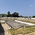
Garrison Cemetery, Srirangapatna

[edit]

The Garrison Cemetery is located in Srirangapatna, on the banks of the river Cauvery, about 300m from the Bangalore Mysore Highway. It has about 307 graves of the European officers killed in the final assault on Tippu Sultan in 1799, and their family members. Among the graves, there are 80 graves of the officers of the Swiss Regiment de Meuron, and the rest of the graves are their family members.[13][14]

Scott’s Bungalow, Seringapatam

[edit]

The Scott’s Bungalow is located in Seringapatam on the banks of the river Cauvery, at about half a mile from the Mysore Gate of the Seringapatam gate.[15] The bungalow was the residence of Col. Scott, an officer of the Madras Army who took part in the siege of Seringapatam in 1799. The bungalow is associated with the legend and tragedy of Col. Scott. The story of Scott’s Bungalow is lamented in a poem by Walter Yeldham called The Deserted Bungalow, published in 1875.[16][17]

Lord Harris's House

[edit]

Between the Garrison Cemetery and Scott’s Bungalow a path leads to Lord Harris's House on the river banks. This house is known as Lord Harris's House or The Doctor's Bungalow or Puraniah's Bungalow. This house was the residence of General Harris, for a short time after the siege of Seringapatam in 1799, and went on to become headquarters of the commanding officer of Seringapatam. In 1809, the house was the scene of a mutiny by officers of the Madras Army, led by Col. Bell, against Sir. George Barlow, the Governor of Madras. Purnaiah, lived in this house after his retirement from service in 1811, and died there on 28 March 1812. A tablet on the wall records the connection of Lord Harris and Puraniah to the house.[18]

Colonel Bailey's Dungeon - ground view

Srirangapatna Fort

[edit]

The fortress is in the west of the island, and is surrounded by double walls. The point at which the British broke through the walls, and thus Tipu Sultan's troops surprised, is marked by an obelisk. Also highlighted is the place where Tipu Sultan was killed by the British forces. In addition, the dungeon in which the Mysore rulers had imprisoned British soldiers.

Colonel Bailey's Dungeon

[edit]

Colonel Bailey's Dungeon was the place where Tipu Sultan used to imprison all the British officers. It is near the death place memorial of Tipu Sultan and is surrounded by gardens on all four sides. Bailey was the only British officer who died in that place and could not make it through the tough conditions and so it was later named after him.

Another version says that the commanding officer of the British at the Battle of Pollilur (1780), Col. Baillie, was imprisoned here after the defeat of his troops in the First Mysore War.

Obelisk Monument

Obelisk Monument

[edit]

Obelisk in Srirangapatna is a memorial erected by the then government of Mysore in memory of the English soldiers died during the siege of Srirangapatna. The Memorial was built during the reign of Krishnaraja Wadiyar IV in 1907, to celebrate the defeat of Tipu in 1799. The inscription on the plaque reads "This monument is erected by the government of Mysore in 1907 in order to commemorate the siege of Seringapatam by the British forces under lieutenant general G. Harris (George Harris, 1st Baron Harris) and its final capture by assault on 4 May 1799. As also the names of those gallant officers who fell during the operations."

Ranganathittu Bird Sanctuary

[edit]

Near the town is the Ranganathittu Bird Sanctuary, where several bird species breed, including the painted stork, open-billed stork, black-headed ibis, river tern, great stone plover and Indian shag.

Sound and light show

In literature

[edit]
  • Bernard Cornwell's Sharpe's Tiger[19] is a fictionalised account of the Battle of Seringapatam. It concentrates on the exploits of the fictional character of Richard Sharpe, and the historic Arthur Wellesley, later the Duke of Wellington.
  • Wilkie Collins' The Moonstone[20] includes a prologue that takes place during the Battle of Srirangapatna, entitled "The Storming of Seringapatam (1799)", during which a British officer steals a sacred Hindu diamond that becomes the mystery at the centre of the novel.
  • John Forster mentions in The Life of Charles Dickens that in a childhood playground of C.D., "he had been... delivered from the dungeons of Seringapatam, an immense pile ('of haycock'), by the victorious British ('boy next door and his two cousins')...". See p. 10 of the Everyman edition published in 1969. First published: London; Chapman and Hall, 1872–1874, in 3 volumes.
[edit]

See also

[edit]

References

[edit]
[edit]
Revisions and contributorsEdit on WikipediaRead on Wikipedia
from Grokipedia
Srirangapatna is a historic island town in , , , formed by the bifurcation of the Cauvery River into northern and southern branches, enclosing an area of approximately 7.2 square kilometers that has served as a pilgrimage and defensive stronghold since the 9th century CE. The town features the Ranganathaswamy Temple, a major Vaishnava shrine dedicated to Lord Ranganatha (a form of ) founded in 894 CE by Ganga chief Tirumalaiah, alongside Hoysala-era fortifications dating to 1120 CE under Udayaditya. From 1761 to 1799, it functioned as the de facto capital of the Mysore Kingdom under and his son , who enhanced its defenses with Islamic architectural influences, including bastions, gateways, and palaces like . Srirangapatna's military significance culminated in the Battle of Seringapatam on May 4, 1799, during the , when British-led forces breached the fort, leading to Tipu Sultan's death and the kingdom's partition. Today, it preserves monuments such as Tipu's mausoleum at Gumbaz and colonial-era dungeons, reflecting a blend of Hindu, Islamic, and European architectural and strategic elements proposed for recognition.

Geography

Location and Topography

Srirangapatna is situated in of state, , approximately 15 kilometers north of city. The town lies at geographic coordinates 12°25′N 76°42′E. It occupies a strategic position on the , with an average elevation of 679 meters above . The topography of Srirangapatna is defined by its location on a riverine formed by the River, which bifurcates near the town into northern and southern branches known as Uttara Kaveri and Dakshina Kaveri, respectively, enclosing the central landmass. A western tributary, the Paschima Vahini (also called Lokapavani River), further delineates the 's boundaries, with the main channel flowing along the eastern side. This configuration measures roughly 5 kilometers east to west and 1.5 kilometers north to south, providing natural through surrounding waterways. The terrain is predominantly flat and low-lying, typical of alluvial floodplains along the , supporting fertile agricultural land with paddies and groves, though the substrate in parts contributes to the area's historical defensibility. The surrounding landscape transitions to undulating plateaus of the region, with elevations rising gradually to nearby hills like Karighatta to the east.

Climate and Biodiversity

Srirangapatna features a tropical monsoon climate (Köppen classification Aw), with distinct hot, dry summers from March to May, a pronounced rainy season from June to October, and mild winters from November to February. Average high temperatures reach 35–38°C (95–100°F) during the hottest months of April and May, while lows dip to 18–20°C (64–68°F) in December and January. Annual precipitation totals approximately 900–1,000 mm (35–39 inches), concentrated in the southwest monsoon, with July recording the highest average of 168 mm (6.6 inches). The region experiences high humidity year-round, often exceeding 70%, contributing to muggy conditions even in the drier months. The area's biodiversity is shaped by its position on the River islands and surrounding riparian zones, fostering riverine ecosystems with tropical moist deciduous and thorn forests. Flora includes over 400 dicotyledonous plant species across 79 families, dominated by (legumes) with 69 species, alongside riverine species like reeds, mangroves in adjacent s, and deciduous trees such as Tectona grandis () and Terminalia spp. Fauna thrives in the aquatic and semi-aquatic habitats, particularly through the nearby , a Ramsar site spanning six islands just 3 km north, which supports over 221 species, including residents like painted storks (Mycteria leucocephala), spot-billed pelicans (Pelecanus philippensis), and oriental darters (Anhinga melanogaster), as well as winter migrants such as grey herons and river terns. Reptiles and mammals in the sanctuary and river environs include mugger crocodiles (Crocodylus palustris), smooth-coated otters (Lutrogale perspicillata), and mahseer fish (Tor spp.), which sustain the for avian predators. The ecosystem's health depends on seasonal flooding, which replenishes wetlands and promotes breeding, though human pressures like and pose risks to endemic and migratory populations.

History

Ancient and Medieval Foundations

The historical foundations of Srirangapatna trace to the 9th century CE during the rule of the Western Ganga dynasty, which governed much of southern Karnataka from their capital at Talakad. An inscription records that a Ganga chieftain named Tirumalaiah established the settlement known as Srirangapura and constructed the initial Sri Ranganathaswamy Temple dedicated to Vishnu in his reclining form as Ranganatha, along with another temple to Tirumala Deva; this event is dated to 984 CE, marking the consecration of the primary temple that gave the town its name. The temple's location on an island formed by the Kaveri River underscored its religious significance as one of the Pancha Ranga Kshetras, sites associated with Vishnu's Ranga form. In the early 12th century, following the decline of Ganga influence and amid regional power shifts, the Hoysala dynasty incorporated Srirangapatna into their domain. Hoysala ruler Udayaditya constructed the town's fort in 1120 CE under the reign of King (1108–1152 CE) to bolster defenses after the fall of Talakad to the Cholas. granted the village to a Vaishnava saint, enhancing its status as a religious center, while later Hoysala king Ballala II (1173–1220 CE) endowed lands to Brahmins, establishing endowments like Tiruvaranga for temple maintenance. These developments fortified the island's strategic and sacred role during the Hoysala era, which emphasized and architectural patronage. After the Hoysala Empire's collapse in the 14th century, Srirangapatna fell under the Empire's control by the 15th century. The empire's rulers reinforced the town's defenses; Timmanna Hebbar rebuilt the fort in the late 15th century on orders from Devaraya II. forces under Saluva Narasimha (1485–1503 CE) subdued local Ummattur chiefs who had fortified the area, and launched campaigns against them in 1511 CE, securing imperial authority. Srirangapatna served as a seat for viceroys until around 1610 CE, reflecting its military importance in the empire's southern frontiers amid conflicts with regional chieftains. This period solidified the town's infrastructure, blending defensive fortifications with ongoing temple expansions.

Rise under Hyder Ali

In 1757, , then a military commander under the Wodeyar rulers of , was summoned to Srirangapatna to bolster defenses against incursions from the and Maratha forces, leveraging the town's island position between the Cauvery and Lokapavani rivers for natural fortification. His successful management of troops—commanding approximately 15,000 soldiers, including European mercenaries and cavalry—amid internal instability between ministers and Nanjaraja elevated his influence in the court, marking Srirangapatna as a pivotal base for consolidating power. Following the Maratha invasion of 1760–1761, which devastated Mysore and exposed the Wodeyar regime's weaknesses, seized de facto control by 1761, sidelining the titular raja and establishing Srirangapatna as the effective political and military capital of his expanding domain. He initiated fortifications, including enhanced walls, bastions, and riverine defenses, transforming the pre-existing 15th-century structure into a robust stronghold capable of withstanding sieges, while also constructing roads, parks, and administrative infrastructure to support governance and logistics. These developments, praised in contemporary European accounts for their efficiency and scale, underscored Srirangapatna's strategic value in Hyder's campaigns against regional rivals, enabling rapid troop movements and supply lines across the Deccan. Under Hyder Ali's rule until his death in 1782, Srirangapatna served as the nerve center for his military reforms, including the integration of prototypes and a that grew to over 100,000 by the late 1770s, funding these through revenue innovations like land assessments and trade monopolies centered on the town's river ports. The site's defensibility proved critical during early Anglo-Mysore conflicts, such as the 1767–1769 war, where Hyder repelled British advances, though accounts from British officers like those in Madras archives highlight the fortifications' role without overstating invincibility, attributing successes more to Hyder's tactical mobility than static defenses alone. This era elevated Srirangapatna from a regional outpost to a symbol of Mysore's resurgence, though reliant on Hyder's personal authority rather than institutional permanence.

Tipu Sultan's Rule: Reforms and Innovations

Tipu Sultan, ruling from 1782 to 1799 with Srirangapatna as his capital, introduced several administrative and economic measures aimed at strengthening the . He implemented a revised land revenue system that sought to standardize assessments and support cultivators by reducing intermediaries, though implementation varied across regions. This approach contributed to increased cultivated land and state revenue during his reign. In military organization, Tipu restructured units along European models and established facilities for producing firearms, including gun manufactories that adopted foreign techniques. His most notable innovation was the expansion of Mysorean technology, featuring iron-cased projectiles with ranges up to 2 kilometers, deployed by specialized numbering around 5,000 troops. Archaeological , including over 1,000 remnants excavated from a well in Nagamangala near Srirangapatna, confirms the scale of production and storage for wartime use. Economically, Tipu promoted by introducing mulberry cultivation and rearing, establishing factories for production and export, which laid foundations for the industry in . He also encouraged foreign technology adoption and state-controlled trade to bolster commerce, including missions to secure alliances and markets abroad. These efforts diversified Mysore's beyond agriculture, though wartime demands often strained resources.

Tipu Sultan's Religious Policies and Atrocities

Tipu Sultan's religious policies emphasized the promotion of as the , with administrative favoritism toward Muslim institutions in Srirangapatna, his capital, including the construction of the Jama Masjid in 1787 and attached madrasas for Islamic education. He reimposed the tax on and in 1788, signaling discriminatory fiscal measures against non-Muslims, though enforcement varied in core territories where Hindu officials were retained for administrative efficiency. While Tipu issued land grants to select Hindu temples in Mysore proper—such as the Sri Ranganathaswamy Temple in Srirangapatna—to secure loyalty amid wars, these acts appear politically motivated rather than indicative of tolerance, as evidenced by his own writings proclaiming and the "Sword of " title. Contemporary accounts and his correspondence reveal a pattern of religious zealotry, particularly in frontier campaigns, where forced Islamization served to consolidate control and depopulate resistant Hindu-majority areas. In Kodagu (Coorg), Tipu's 1785 invasion targeted the Kodava population, resulting in the capture of 70,000 to 85,000 individuals; approximately 10,000 were forcibly circumcised and converted to , while others were enslaved, killed, or deported to , with massacres reported at where resistors were hurled from cliffs. British officer James S. Kirkpatrick's eyewitness-derived accounts detail the systematic uprooting, with survivors resettled as laborers in Srirangapatna and irrigated lands to bolster Muslim demographics. These actions decimated Kodava society, reducing the population by over half and erasing indigenous Hindu practices through coercion. The Malabar campaigns from 1788 to 1792 exemplified broader atrocities, with Tipu ordering the destruction of hundreds of Hindu temples and mass forced conversions of Nairs and other castes; William Logan's (1887), drawing on local records and temple inscriptions, documents the conversion of thousands, plundering of temple treasures, and enslavement or execution of resisters, framing it as a religious rather than mere suppression. Tipu's letter to Abdur Razack in January 1790 boasts of razing "almost beyond computation" temples in Calicut alone, many with gold, silver, or copper roofs, extracting buried idols' treasures to fund . In Srirangapatna, the Varahaswami Temple was demolished, aligning with selective desecrations in the capital to enforce Islamic dominance. Christians faced parallel persecution, notably in 1784 when Tipu captured 60,000 from the coast, forcing a 300-mile to Srirangapatna amid and exposure; up to 20,000 perished en route or in captivity, with survivors coerced into conversion or labor, and non-conformists imprisoned in island dungeons or executed. Church records and Portuguese accounts corroborate the scale, attributing it to Tipu's view of Christians as Portuguese allies. These policies, while contested by some academics emphasizing strategic , are substantiated by primary letters, local chronicles, and demographic disruptions, outweighing isolated patronage amid in modern historiography favoring anti-colonial narratives over victim testimonies.

Anglo-Mysore Wars and Fall of the Capital

The Anglo-Mysore Wars comprised four conflicts between the British East India Company and the Kingdom of Mysore, spanning 1767 to 1799, during which Srirangapatna functioned as the fortified capital under Hyder Ali and Tipu Sultan. The First Anglo-Mysore War (1767–1769) erupted after Mysore intervened against British allies in the Carnatic, leading to Hyder Ali's forces besieging Madras and extracting concessions via the Treaty of Madras in 1769. The Second War (1780–1784) saw Hyder Ali and Tipu invade the Carnatic in retaliation for British alliances, culminating in protracted campaigns under British commander Eyre Coote, ending in the inconclusive Treaty of Mangalore. The Third Anglo-Mysore War (1790–1792) began with Tipu Sultan's invasion of , prompting a British coalition under Charles Cornwallis to advance on Srirangapatna; after capturing associated forts and besieging the capital in 1791, Tipu averted total defeat by ceding half his territory under the in 1792, which also involved hostage exchanges including Tipu's sons. Tensions persisted as Tipu pursued French alliances amid the , leading Richard Wellesley to launch the in 1798 without declaration, coordinating with and Maratha forces. In February 1799, British armies under General George Harris (Madras force of about 20,000) and General David Baird (Bombay force) converged on , defeating Tipu's army at seed sowing time near Srirangapatna on March 27 after inflicting heavy casualties. of Srirangapatna commenced on 5 when British troops seized the aqueduct supplying the fortress, establishing batteries and parallel trenches despite rocket and fire from Mysorean defenses. By late , breaches were effected in the northern walls through sustained , setting the stage for . On May 4, 1799, British storming parties, including Highlanders and sepoys led by Baird, scaled the breaches amid fierce resistance, overwhelming the garrison; , fighting near the Hoally Gateway, was shot multiple times and killed, with his body identified later in a nearby house. British losses totaled around 450 killed and wounded, contrasting with thousands of Mysorean dead and the fortress's capture, followed by of treasures before order was restored. The fall ended Mysore's , with the British imposing a on the restored Wodeyar dynasty, partitioning territory among allies, and retaining control over Srirangapatna as a military outpost.

British Administration and Legacy

Following the storming of Srirangapatna on 4 May 1799 during the , British East India Company forces under General George Harris captured the fortress, resulting in Tipu Sultan's death and the end of his independent rule. The British restored the Wodeyar dynasty by enthroning the five-year-old Krishna Raja Wodeyar III as , shifting the capital to city and establishing a that mandated a British presence and oversight via a Resident to ensure loyalty and payment of tribute. Srirangapatna transitioned from a fortified capital to a peripheral town under administration, with its defenses partially demolished to prevent rebellion and its strategic island position repurposed for garrison duties. British control over , including Srirangapatna, involved through the until 1831, when disputes over adoption led to direct administration under British Commissioners, such as Mark Cubbon (1831–1861), who centralized governance and developed across the territory. During this period, Srirangapatna experienced localized resistance, exemplified by the 1857 uprising where residents revolted against British authority, destroying records and attacking officials before being suppressed. The town served as a reminder of conquest, with British officers occupying former structures like Scott's , originally Tipu's, for residency. Full restoration occurred in 1881 under Maharaja Chamarajendra Wodeyar X, but British paramountcy persisted until 1947. The British legacy in Srirangapatna includes commemorative monuments honoring their military sacrifices and engineering feats. The , located at the fortress's western corner, stands as a war memorial to British officers and soldiers killed during the 1799 siege, symbolizing victory over . Colonel Bailey's Dungeon, an 18th-century prison constructed under Tipu to hold captives from the 1780 Battle of Pollilur—including Colonel William Baillie, who died there in 1782—was preserved and renamed by the British as a grim testament to earlier conflicts and prisoner mistreatment. Infrastructure advancements featured the Wellesley Bridge, a stone arch structure spanning the River, completed in 1804 under Dewan Purnaih's supervision during British oversight to enhance connectivity to the island town; measuring 512 feet long, 20 feet wide, and 22 feet high, it facilitated trade and military movement. These elements underscore British efforts to consolidate control, memorialize losses, and integrate the region into their Indian empire, while the site's preservation post-independence highlights enduring historical significance.

Post-Independence Developments

Upon India's independence in 1947, Srirangapatna, as part of the of , acceded to the Dominion of India and subsequently integrated into the expanded , which was renamed following the States Reorganisation Act of 1956. The town retained its historical significance while transitioning to administrative oversight by state authorities, with focus shifting toward preservation amid growing national emphasis on cultural heritage. Post-independence infrastructure enhancements included repairs to historical structures, such as the fort walls and gateways, undertaken by state and central agencies to mitigate decay from prior neglect. The has maintained key monuments, including the fort and associated military sites, ensuring structural integrity while adapting them for public access. Conservation efforts extended to the Ranganathaswamy Temple and surrounding pilgrimage infrastructure, supporting ongoing . Tourism development gained momentum in the late 20th and early 21st centuries, with Tourism's 2017 Destination Development initiative outlining upgrades to pathways, signage, and visitor facilities around the island town's core sites. In November 2024, the state government approved a ₹100 Detailed Project Report for holistic enhancement, encompassing heritage conservation—such as ancient ghats, war relics, and the Wadiyars' birthplace—alongside modern amenities like improved connectivity and eco-friendly infrastructure. Urban planning has accelerated recently, with a 2025 master plan designating residential expansions along the Bengaluru-Mysuru Highway and Wellesley Bridge Road to accommodate while green buffers near heritage zones. Proposals announced in July 2025 emphasized taluk-wide circuits integrated with , leveraging the Cauvery basin's fertility for agro-tourism. These initiatives reflect a balance between economic diversification—driven by and visitor influx—and safeguarding the town's archaeological footprint against unchecked .

Demographics and Economy

Population Dynamics

As per the , the town of Srirangapatna recorded a of 25,061, consisting of 12,274 males and 12,787 s, yielding a of 1,042 females per 1,000 males. The rate stood at 79.98%, with male at 84.45% and at 75.69%. These figures reflect a typical of a semi-urban historical center in , with a slight and above-average compared to the state average of 75.36%. The town's population growth has been notably subdued, registering an annual rate of 0.55% between the and censuses, equating to a decadal increase of about 5.6% from an estimated 23,737 residents in . This contrasts with the higher decadal growth of 10.56% in the encompassing Shrirangapattana taluka, which reached 180,191 persons in , suggesting outward migration or constrained expansion within the town limits due to its fortified heritage status and regulatory protections on development. Factors such as proximity to larger urban hubs like (approximately 15 km away) likely contribute to commuter patterns rather than in-situ expansion, maintaining the town's density at 2,157 persons per square kilometer over 11.62 km². Post-2011 trends remain unenumerated due to the postponement of the 2021 census amid the COVID-19 pandemic, but non-official projections estimate modest continuation, reaching around 36,400 by 2025, aligned with Karnataka's rural-urban fringe dynamics where tourism sustains limited influx without industrial booms. Historically, as a former capital under Hyder Ali and Tipu Sultan until 1799, the town likely supported a denser population tied to military and administrative functions, though precise pre-20th-century figures are unavailable in census records; subsequent British administration and post-independence de-emphasis as a political center precipitated stabilization rather than surge.

Economic Activities and Urbanization

The economy of Srirangapatna taluk revolves primarily around agriculture, which dominates employment and output due to the fertile lands irrigated by the Kaveri River. Principal crops include paddy, , and ragi, with the taluk featuring higher irrigated acreage for and paddy compared to neighboring areas. In the broader encompassing Srirangapatna, cultivation spans approximately 80,000 hectares, 25,000 to 40,000 hectares, and the region produces 2.6 million metric tonnes of and 1 million metric tonnes of annually, supported by mills, sugar factories, and agro-processing clusters. Paddy and remain the core crops in Srirangapatna, contributing to the district's agrarian base where over half the geographical area is under cultivation. Tourism is an increasingly vital sector, capitalizing on the town's historical fortifications, Tipu Sultan's legacy sites, and the Sri Ranganathaswamy Temple, which draw pilgrims and visitors. In November 2024, the Karnataka government initiated a ₹100 Detailed Project Report to enhance , aiming to elevate the area's appeal as a heritage destination. This development is projected to spur ancillary services, , and small-scale , with real-estate investments rising in commercial and lodging facilities. Supplementary economic activities include limited agro-based industries such as milk processing and oil extraction, alongside household-level enterprises, though the workforce remains heavily tilted toward cultivators (main workers) and agricultural laborers. Urbanization proceeds at a measured pace, reflecting the taluk's semi-rural profile amid regional pressures from Mysore's expansion. The town's population stood at 25,061 per the 2011 census, with an annual growth rate of 0.55% from 2001–2011, reaching about 28,000 by 2025—a mere 2% increase over 14 years. The Srirangapatna-Mysore corridor has seen pronounced urban sprawl, with built-up land expanding 128% in analyses through the early 2000s, driven by dispersion and infrastructure links. Recent initiatives, including a 2025 master plan for infrastructure upgrades and tourism integration, signal intent to manage growth, accommodate hospitality expansions, and mitigate sprawl risks while preserving the island town's compact fort core, where 64.4% of residents live. Decadal population growth in the taluk reached 10.56% in the 2001–2011 period, outpacing some peers but underscoring agriculture's enduring pull over rapid urban migration.

Religious and Cultural Importance

Sri Ranganathaswamy Temple and Vaishnava Heritage

The Sri is a major Vaishnava shrine dedicated to , the reclining form of on the serpent Adisesha, situated on the island of Srirangapatna amid the River. As the Adi Ranga, it serves as the uppermost of the Pancharanga Kshetras, a series of five sacred Ranganatha temples along the revered in Sri Vaishnava tradition. The temple's significance stems from its association with ancient legends, including the manifestation of Ranganatha at the behest of the river goddess and penance by sage Gautama. Construction of the temple dates to 984 CE, initiated by Tirumalaiah under the . In the 12th century, Hoysala ruler granted the temple as an to the Sri Vaishnava philosopher Ramanujacharya, embedding it deeply in the Sri Vaishnava . Subsequent renovations occurred under Hoysala king , with further contributions from the Wodeyar kings of , reflecting sustained patronage across dynasties. Even during the rule of and , the temple retained its sanctity and received respect, underscoring its enduring cultural prominence. Architecturally, the temple exemplifies Dravidian style with influences, featuring a towering at the entrance, two expansive rectangular prakarams, and a supported by intricately carved pillars depicting mythological scenes. The sanctum houses the central deity of flanked by , alongside subsidiary shrines for , , Gopalkrishna, Hanuman, and Alwar saints, highlighting its role as one of the 108 Abhimana Kshetras of . In Vaishnava heritage, the temple upholds Sri Vaishnava rituals and festivals such as the Bangarada Garudotsava, Sriranga Jayanti, and Uyyalotsava, drawing pilgrims for worship and processions that emphasize devotion to Vishnu's incarnations. Its position as a foundational site in the Pancharanga pilgrimage circuit reinforces the valley's centrality to South Indian , linking devotees across regions through shared iconography and theology. The temple remains under the management of the , preserving its historical and spiritual integrity.

Local Festivals and Pilgrimages

The Sri Ranganathaswamy Temple in Srirangapatna serves as the focal point for local festivals, drawing devotees for Vaishnava rituals tied to the site's status as the northernmost of the Pancha Ranga Kshetras. , observed during the Hindu month of Margashirsha (typically December-January), features special processions and pujas of the deity in reclining form, with temple doors opened for extended darshan attracting thousands from and beyond. Other key temple festivals include Sriranga Jayanti, commemorating the deity's installation in the temple, marked by ceremonial processions and offerings; Bangarada Garudotsava, featuring a golden (vehicle) carrying the ; and Uyyalotsava, a swing with devotional songs and rituals. celebrations involve nine days of pujas, yagas, homas, and sacred offerings, culminating in observances adapted to local Vaishnava traditions. Srirangapatna also hosts a localized version of the Dasara festival from September 25 to 28 annually, inaugurated with cultural processions, traditional competitions, and food events that highlight regional heritage while echoing the larger . As a revered in the Nalayira Divya Prabandham, the temple functions as a year-round destination for Sri Vaishnavas seeking theerthavari (holy bath) in the River and darshan of the ancient idol, with pilgrim influx peaking during these festivals.

Heritage Sites and Attractions

Fortifications and Military Structures

The fortifications of Srirangapatna constitute a jaladurga, or water fort, utilizing the island's strategic position amid the branches of the Cauvery River for natural defense, augmented by man-made moats and extensive walls. Originally constructed around 1120 CE by Hoysala king Udayaditya following the fall of , the mud fort was reinforced with stone, brick, and lime mortar by subsequent rulers, including Vijayanagara officials in the and kings from 1610 CE onward. undertook major renovations in 1791 CE, employing French engineers to enhance its defensive capabilities against British forces. The enclosed area spans approximately 5 square kilometers on the western part of the island. The defensive walls feature thick construction with an outer stone casing and inner mud rampart, topped by a 2-3 meter wide platform and for artillery placement. Bastions, varying in shape from square to rectangular and oblong, project at intervals along the walls, each equipped with batteries for mounting; notable examples include the Bateri, an oblong bastion formerly bearing a heavy overlooking a , and the Kalegaudana Bateri in the southeast corner. Three artificial moats protect the southern and , while the northern and western sides rely on two man-made moats combined with the natural river barrier. Six gateways pierce the perimeter, constructed of stone, brick, and lime mortar, typically measuring 5.50 meters in height, 3.75 meters in width, and 14.75 meters in length; prominent entrances include the southern Mysore Gate (Anekote Bagilu) built by in 1791 CE and the eastern Bangalore Gate (Ganjam Gate) serving as the primary access. Military structures within the fort encompass armories and prisons designed for wartime exigencies. Six magazines for storing and arms were positioned between the gates to facilitate rapid resupply. The dungeons served as holding facilities for prisoners of ; Bailey's Dungeon, located in the northern sector and measuring 30.50 by 12.20 meters, was built of brick and to confine British captives, including John Bailey, who perished there in 1782 CE during captivity under . Adjacent to the Inman's Dungeon in the northeast, sized 13.75 by 9.75 meters, which later held the Maratha rebel Dhondia Vagh until its discovery in 1895 CE. These subterranean chambers underscore the fort's role in the Anglo-Mysore conflicts, particularly the sieges culminating in 1799 CE.

Palaces and Mausoleums

The Daria Daulat Bagh, commonly known as Tipu Sultan's Summer Palace, functioned as a seasonal residence for Tipu Sultan, ruler of the Kingdom of Mysore, during the late 18th century. This wooden structure, primarily constructed from teak, features a rectangular layout with open verandas supported by ornate pillars and intricate carvings. It houses murals depicting military campaigns, including the Anglo-Mysore Wars, with notable paintings illustrating the British capture of Srirangapatna on May 4, 1799. Designated as a monument of national importance by the , the palace exemplifies blended with local craftsmanship, reflecting Tipu Sultan's patronage of art amid his conflicts with the British East India Company. The interiors include furniture and motifs symbolizing Tipu's emblem, the "Tiger of ." Visitors can access preserved exhibits, though the original fort palace was largely destroyed during the 1799 siege. The Gumbaz mausoleum, erected by between 1782 and 1784, primarily honors his father , who died in 1782, and mother Fakhr-un-Nisa. This square edifice, characterized by ivory-inlaid doors, black marble columns, and a dome, is set within a manicured enclosure. Following 's fatal wounding in the on May 4, 1799, his remains were interred alongside his parents, with tombs draped in silk—Tipu's in yellow, Hyder Ali's in violet. Protected under the Ancient Monuments and Archaeological Sites and Remains Act, the Gumbaz preserves cenotaphs and inscriptions detailing the rulers' lineages and achievements, underscoring the site's role in commemorating Mysore's Wodeyar predecessors and Hyder-Tipu . The surrounding trees and water channels enhance its serene, funerary ambiance, drawing historical interest despite limited primary records on specifics.

Colonial-Era Memorials

The Obelisk Monument, located at the westernmost corner of the Srirangapatna Fortress near the fort walls, was erected in 1907 by the Government of under Nalwadi Krishnaraja Wadiyar to commemorate the British victory over during the siege and capture of Srirangapatna on 4 May 1799. This structure honors the British officers and soldiers who fell in the operations of the , with inscriptions detailing total casualties: 192 killed, 657 wounded, and 25 missing from British corps, alongside 108 killed, 385 wounded, and 97 missing from native troops of the Bombay and Madras Presidencies. Additional panels list the names, ranks, and regiments of European officers who died, serving as a specific to their sacrifices amid the conflict that ended Tipu Sultan's rule and restored Wadiyar authority under British oversight. Adjacent to the Garrison Cemetery on the banks of the Cauvery River, near the Bangalore-Mysore Highway, the Baillie Monument was commissioned in 1816 by Lieutenant-Colonel John Baillie to honor his uncle, Lieutenant-Colonel William Baillie, who died on 13 November 1782 while in captivity following his capture at the Battle of Pollilur in 1780 during the Second Anglo-Mysore War. The monument stands as a testament to British prisoners held by and , with conservation efforts undertaken in 2010 by the Regimental Growth and Restoration Association (RGRA) in collaboration with the Baillie family and the British Association for Cemeteries in (BACSA). The nearby Garrison Cemetery, established after the 1799 assault, contains over 300 graves of European officers slain in the final siege of , including 80 from the Swiss de Meuron Regiment that fought alongside British forces. These burials, dating primarily from the early 19th century, reflect the human cost of the Anglo-Mysore Wars to colonial troops and their families, with restoration completed in phases, including a 2007 project by RGRA and ongoing maintenance supported by BACSA contributions such as £2,000 in 2017 for signage and preservation. The site underscores the British establishment of commemorative spaces in the wake of their military successes in the region. Colonel Bailey's Dungeon, situated north of the Ranganathaswamy Temple on the Cauvery's banks, served as a constructed under and utilized by to confine captured British officers, including those from earlier conflicts like the 1780-1782 imprisonments leading to deaths such as William Baillie's. Named after the officer who perished there, the structure—measuring approximately 30.5 meters by 12.2 meters and built of brick and mortar—has been preserved as a historical site evoking the captivity endured by British personnel during the Mysore Wars, though it predates full colonial control.

Temples and Natural Viewpoints

The Sri Ranganathaswamy Temple stands as the central religious landmark in Srirangapatna, dedicated to in his reclining form on the serpent Adisesha. Erected in 984 CE by Tirumalaiah, a chieftain serving the , the temple occupies an island position amid the River's branches, enhancing its sanctity as a riverside abode of the . Historical records from 894 CE reference foundational grants for worship in the area, with subsequent patronage from Hoysala and rulers expanding its Dravidian-style and . As the inaugural site among the Pancharanga Kshetras—five revered temples along the —the temple draws Sri Vaishnava pilgrims for rituals emphasizing the river's purifying role in devotion. Other notable temples include the Nimishamba Temple, located across the , honoring a form of believed to grant wishes instantaneously per local lore, though empirical verification of such claims remains anecdotal. The Swamy Temple features the lion-man avatar of , reflecting broader Vaishnava iconography prevalent in the region since . These sites underscore Srirangapatna's layered Hindu heritage, blending Ganga-era origins with later imperial enhancements, without evidence of syncretic impositions disrupting core practices. Karighatta hill, approximately 6 kilometers from Srirangapatna, combines a hilltop Srinivasa Temple dedicated to Venkateshwara with expansive natural vistas. The temple, accessible via 450 steps or a 2-kilometer asphalted , crowns a black outcrop near the Lokapavani-Cauvery , offering unobstructed sights of the river's meanders, Srirangapatna's fortifications, and distant plains. This elevated perch provides a strategic overlook historically tied to the area's , where the Kaveri's flow shapes both and settlement patterns, though modern emphasizes its serene, panoramic appeal over prior military utility. Srirangapatna further enhances riverine viewpoints, with cascading waters visible near Tipu Sultan's ruins, facilitating contemplation of the landscape's hydraulic dynamics.

Controversies and Modern Debates

Debates on Tipu Sultan's Legacy

Tipu Sultan's legacy remains deeply contested, with portrayals ranging from a pioneering resistor of British colonialism to a ruler marked by and targeted persecutions. During his reign from 1782 to 1799, with Srirangapatna as his capital, Tipu employed iron-cased in battles against the British , achieving early successes in the First and Second Anglo-Mysore Wars (1767–1769 and 1780–1784), which some historians credit with inspiring modern rocketry. However, primary accounts and regional records document extensive forced conversions and violence against non-Muslims, particularly in conquered territories outside his heartland, undermining claims of uniform tolerance. Critics highlight Tipu's campaigns in Malabar and , where between 1788 and 1792, his forces reportedly destroyed over 8,000 temples, looted treasures from sites like the Mamankam festival grounds, and coerced conversions of under threat of enslavement or death, with estimates of 30,000–40,000 affected in Cochin and Calicut alone. In the Kodagu region, he ordered the capture of 70,000–85,000 Kodavas (Coorgs), executing resistors and forcibly converting or relocating survivors to serve as soldiers or laborers, as recorded in local gazetteers and survivor testimonies preserved in archives. Similarly, the 1784 captivity of approximately 60,000–80,000 involved mass deportations to Srirangapatna for forced labor on fortifications, with around 20,000–30,000 perishing from disease, starvation, or execution before British liberation in 1799; many survivors were compelled to convert to or face family separations. These actions, often framed by Tipu in his own letters as against "infidels," contrast with relatively stable Hindu-majority administration in core , suggesting pragmatic alliances there but ideological zeal in expansions. Proponents emphasize Tipu's administrative innovations, such as state-controlled , coinage reforms, and a coin-based economy that boosted trade, alongside his 1799 death defending Srirangapatna against British forces in the . Yet, even sympathetic accounts acknowledge the evidentiary weight of contemporary court records and British-captured documents detailing plunder and conversions, which were not mere wartime propaganda but corroborated by local Christian and Hindu petitions to rulers. In contemporary Karnataka, these historical actions fuel politicized disputes, particularly around Tipu Jayanti celebrations initiated in 2015 under rule, which portray him as a secular icon but provoke protests in Kodagu and Mangalore over unaddressed atrocities; the BJP government in 2019 removed Tipu-glorifying textbook chapters, citing biased nationalist historiography that downplays primary evidence of bigotry. Srirangapatna sites like Tipu's tomb and Daria Daulat palace draw tourists but also symbolize this divide, with demands for contextual plaques on persecutions amid accusations of selective memory in academia, where left-leaning narratives often prioritize anti-colonial framing over granular archival data from regional sources.

Recent Heritage Disputes

In November 2024, the Central government filed a petition in the Karnataka High Court seeking the removal of an unauthorized madrasa operating within the Jama Masjid, a protected monument under the Archaeological Survey of India (ASI), citing violations of Sections 7, 8, and 16 of the Ancient Monuments Preservation Act, 1958. The petition argued that the madrasa encroaches on the mosque's premises, which was constructed during Tipu Sultan's rule in the late 18th century. The Karnataka Waqf Board opposed the eviction, asserting control over the site. Petitioners have claimed that Tipu Sultan demolished an Anjaneya (Hanuman) temple at the location and built the mosque using its debris, based on historical reports from the Mysore Archaeological Department, prompting calls for ASI excavation and survey. In May 2024, the High Court issued notices to the state government for such a survey following a petition alleging the site's disputed origins. Earlier, in June 2022, Hindu organizations attempted to perform rituals inside the mosque, leading to the imposition of Section 144 restrictions to prevent unrest. In January 2025, the Waqf Board asserted claims over more than 70 properties in Srirangapatna taluk, including heritage sites like the Tipu Armoury, ASI buildings, museums, and government-owned lands, sparking protests from farmers and local groups concerned about land mismanagement and loss of historical assets. A was observed on January 20, 2025, to oppose the inclusion of agricultural and heritage lands in records. These claims have raised questions about the verification of property records and their impact on conservation efforts for monuments tied to both kingdom and colonial history.

References

Add your contribution
Related Hubs
User Avatar
No comments yet.