.jpg)
Community hub
Crawley
View on Wikipedia
Crawley (ⓘ) is a large town and borough in West Sussex, England. It is 28 miles (45 km) south of London, 18 miles (29 km) north of Brighton and Hove, and 32 miles (51 km) north-east of the county town of Chichester. Crawley covers an area of 17.36 square miles (44.96 km2) and had a population of 118,493 at the time of the 2021 Census. Southern parts of the borough lie immediately next to the High Weald National Landscape.
Key Information
_-_geograph.org.uk_-_2555359.jpg)
.jpg)
.jpg)
.jpg)


The area has been inhabited since the Stone Age,[2] and was a centre of ironworking in the Iron Age and Roman times. The area was probably used by the kings of Sussex for hunting.[3] Initially a clearing in the vast forest of the Weald, Crawley began as a settlement on the boundary of two of the sub-regions particular to Sussex, known as Rapes, the Rape of Bramber and the Rape of Lewes. Becoming a market town in 1202, Crawley developed slowly, serving the surrounding villages in the Weald. In the medieval period, its location on the main road from London to the port of Shoreham helped the town to grow; and when Brighton became a fashionable seaside town in the 18th century, the passing trade encouraged the development of coaching inns. A rail link to London and Brighton opened in 1841, encouraging further development.
After World War II, the British Government planned to move large numbers of people and jobs out of London and into new towns around South East England. The New Towns Act 1946 (9 & 10 Geo. 6. c. 68) designated Crawley as the site of one of these.[4] A master plan was developed for the establishment of new residential, commercial, industrial and civic areas, and rapid development greatly increased the size and population of the town over a few decades. The town expanded further in 1974 to include Gatwick Airport, Britain's second busiest international airport and, in 2024, the tenth busiest in Europe.[5]
The town contains 14 residential neighbourhoods radiating out from the core of the old market town, and separated by main roads and railway lines. The nearby communities of Ifield, Pound Hill and Three Bridges were absorbed into the new town at various stages in its development. Established in 2019, the south-western suburb of Kilnwood Vale lies outside of the borough boundary in the neighbouring district of Horsham.[6] Economically, the town has developed into the main centre of industry and employment between London and Brighton. Its large industrial area supports manufacturing and service companies, many of them connected with the airport. The commercial and retail sectors continue to expand.[4] In the late 20th century and early 21st century, the town has attracted a diverse and multicultural population. It is home to about two-thirds of the UK's population of Chagossians.[7]
History
[edit]Origins
[edit]The area may have been settled during the Mesolithic period: locally manufactured flints of the Horsham Culture type have been found to the southwest of the town.[2] Tools and burial mound from the Neolithic period, and burial mounds and a sword from the Bronze Age, have also been discovered.[8][9] Crawley is on the western edge of the High Weald, which produced iron for more than 2,000 years from the Iron Age onwards.[10] Goffs Park—now a recreational area in the south of the town—was the site of two late Iron Age furnaces.[11] Ironworking and mineral extraction continued throughout Roman times, particularly in the Broadfield area where many furnaces were built.[8][12]
.JPG)
Passing through the north of the modern borough, the historic Sussex–Surrey border follows ridges and a trackway, in contrast to the Sussex–Kent border to the east, which follows waterways.[13] According to Mark Gardiner, the border dates at least as far back as the Saxon period, although may in fact be earlier and represent the border between Roman cantons or Iron Age kingdoms.[13] In the 5th century, Saxon settlers named the area Crow's Leah—meaning a crow-infested clearing, or Crow's Wood.[14] This name evolved over time, and the present spelling appeared by the early 14th century.[8] By this time, nearby settlements were more established: the Saxon church at Worth, for example, dates from between 950 and 1050 AD.[15]
Although Crawley itself is not mentioned in the Domesday Book of 1086,[16] the nearby settlements of Ifield and Worth are recorded.[17] Crawley's High Street was built on part of the route from London to the port of New Shoreham, a major port in the 12th and 13th centuries that was on the most direct route between London and Normandy, used by the king and his knights and soldiers. The first written record of Crawley dates from 1202, when King John issued a licence for a weekly market on Wednesdays.[18] As a small market town, Crawley grew slowly in importance over the next few centuries and as the Wealden iron industry declined, the town became an important centre for smuggling between the Sussex coast and London. Later in the 18th century, Crawley was boosted by the construction of the turnpike road between London and Brighton. When this was completed in 1770, travel between the newly fashionable seaside resort of Brighton and London became safer and quicker, and Crawley (located approximately halfway between the two) prospered as a coaching halt.[19] By 1839 it offered almost an hourly service to both destinations.[20][21] The George, a timber-framed house dating from the 15th century, expanded to become a large coaching inn, taking over adjacent buildings. Eventually an annexe had to be built in the middle of the wide High Street; this survived until the 1930s.[22] The original building has become the George Hotel, with conference facilities and 84 bedrooms; it retains many period features including an iron fireback.[23][24]
Crawley's oldest church is St John the Baptist's, between the High Street and the Broadway. It is said to have 13th-century origins,[25] but there has been much rebuilding (especially in the 19th century) and the oldest part remaining is the south wall of the nave, which is believed to be 14th century. The church has a 15th-century tower (rebuilt in 1804) which originally contained four bells cast in 1724. Two were replaced by Thomas Lester of London in 1742; but in 1880 a new set of eight bells were cast and installed by the Croydon-based firm Gillett, Bland & Company.[26][27][28]
Railway age and Victorian era
[edit]
The Brighton Main Line was the first railway line to serve the Crawley area. A station was opened at Three Bridges (originally known as East Crawley)[29] in the summer of 1841. Crawley railway station, at the southern end of the High Street, was built in 1848 when the Horsham branch was opened from Three Bridges to Horsham. A line was built eastwards from Three Bridges to East Grinstead in 1855. The village of Three Bridges had become the hub of transport in the area by this stage: one-quarter of its population was employed in railway jobs by 1861, mainly at the London, Brighton and South Coast Railway's railway works near the station.[30] The Longley company—one of South East England's largest building firms in the late 19th century, responsible for buildings including Christ's Hospital school and King Edward VII Sanatorium in Midhurst—moved to a site next to Crawley station in 1881.[31] In 1898 more than 700 people were employed at the site.[32]
There was a major expansion in house building in the late 19th century. An area known as "New Town" (unrelated to the postwar developments) was created around the railway level crossing and down the Brighton Road;[30][33] the West Green area, west of the High Street on the way to Ifield, was built up; and housing spread south of the Horsham line for the first time, into what is now Southgate. The population reached 4,433 in 1901, compared to 1,357 a century earlier.[34] In 1891, a racecourse was opened on farmland at Gatwick, to the north of Crawley. Built to replace a steeplechase course at Waddon near Croydon in Surrey, it was used for both steeplechase and flat racing, and held the Grand National during the years of World War I.[8] The course had its own railway station on the Brighton Main Line.[35]
In the early 20th century, many of the large country estates in the area, with their mansions and associated grounds and outbuildings, were split up into smaller plots of land, attracting haphazard housing development and small farms.[36] By the outbreak of World War I in 1914 Crawley had grown into a small but prosperous town, serving a wide rural area and those passing through on the London–Brighton road (the present A23). Three-quarters of the population had piped water supplies, all businesses and homes had electricity, and piped gas and street lighting had been in place for 50 years.[30] An airfield was opened in 1930 on land near the racecourse. This was a private concern until the Second World War when it was claimed by the Royal Air Force.[8]
New Town
[edit]In May 1946, the New Towns Act of 1946 identified Crawley as a suitable location for a New Town;[4] but it was not officially designated as such until 9 January 1947.[37] The 5,920 acres (2,396 ha) of land set aside for the new town were split across the county borders between East Sussex, West Sussex and Surrey. Architect Thomas Bennett was appointed chairman of Crawley Development Corporation. Members of the working group developing a master plan included Lawrence Neal, Alwyn Sheppard Fidler, Caroline Haslett, Molly Bolton, Sir Edward Gillett, Eric Walter Pasold and Alderman James Marshall.[38] A court challenge to the designation order meant that plans were not officially confirmed until December 1947. By this time, an initial plan for the development of the area had been drawn up by Anthony Minoprio.[39] This proposed filling in the gaps between the villages of Crawley, Ifield and Three Bridges.[40] Bennett estimated that planning, designing and building the town, and increasing its population from the existing 9,500 to 40,000, would take 15 years.[41]

Work began almost immediately to prepare for the expansion of the town. A full master plan was in place by 1949. This envisaged an increase in the population of the town to 50,000, residential properties in nine neighbourhoods radiating from the town centre, and a separate industrial area to the north.[39] The neighbourhoods would consist mainly of three-bedroom family homes, with a number of smaller and larger properties. Each would be built around a centre with shops, a church, a pub, a primary school and a community centre.[40] Secondary education was to be provided at campuses at Ifield Green, Three Bridges and Tilgate.[42] Later, a fourth campus, in Southgate, was added to the plans.[43]
At first, little development took place in the town centre, and residents relied on the shops and services in the existing high street. The earliest progress was in West Green, where new residents moved in during the late 1940s. In 1950 the town was visited by the then heir to the throne, Princess Elizabeth, when she officially opened the Manor Royal industrial area. Building work continued throughout the 1950s in West Green, Northgate and Three Bridges, and later in Langley Green, Pound Hill and Ifield. In 1956, land at "Tilgate East" was allocated for housing use, eventually becoming the new neighbourhood of Furnace Green.[39] From the mid-1950s, expanded shopping facilities to the east of the existing High Street were provided. The first stage to open was The Broadwalk in 1954, followed by the opening of the Queen's Square development by the recently crowned Queen Elizabeth II in 1958. Crawley railway station was moved eastwards towards the new development.[39]
.JPG)
Expectations of the eventual population of the town were revised upwards several times. The 1949 master plan had allowed for 50,000 people, but this was amended to 55,000 in 1956 after the Development Corporation had successfully resisted pressure from the Minister for Town and Country Planning to accommodate 60,000. Nevertheless, plans dated 1961 anticipated growth to 70,000 by 1980, and by 1969 consideration was given to an eventual expansion of up to 120,000.[39] By April 1960, when Thomas Bennett made his last presentation as chairman of the Development Corporation, the town's population had reached 51,700; 2,289,000 square feet (212,700 m2) of the factory and other industrial space had been provided; 21,800 people were employed, nearly 60% of whom worked in manufacturing industries, and only seventy people were registered as unemployed. The corporation had built 10,254 houses, and private builders provided around 1,500 more. Tenants were by then permitted to buy their houses and 440 householders had chosen to do so by April 1960.[41]
A new plan was put forward by West Sussex County Council in 1961. This proposed new neighbourhoods at Broadfield and Bewbush, both of which extended outside the administrative area of the then Urban District Council. Detailed plans were made for Broadfield in the late 1960s; by the early 1970s building work had begun. Further expansion at Bewbush was begun in 1974, although development there was slow. The two neighbourhoods were both larger than the original nine: together, their proposed population was 23,000. Work also took place in the area now known as Ifield West on the western fringes of the town.[44]
By 1980, the council identified land at Maidenbower, south of the Pound Hill neighbourhood, as being suitable for another new neighbourhood, and work began in 1986. However, all of this development was undertaken privately, unlike the earlier neighbourhoods in which most of the housing was owned by the council.[44] In 1999, plans were announced to develop the fourteenth neighbourhood on land at Tinsley Green to the northeast of the town; this was given the go-ahead in 2011 and has been named Forge Wood after the ancient woodland that is enclosed within the development. After the proposals were temporarily halted while a possible expansion at Gatwick Airport was announced,[45] construction started in 2015.[46] Forge Wood is to have a maximum of 1,900 homes.[47] Another major residential development, Kilnwood Vale, began in 2012 adjacent to the western side of Crawley but separate from it, in district of Horsham. A plan for a new railway station fell through.[6]
Governance
[edit]Local government
[edit]
.jpg)

The borough is part of a two-tier arrangement, with service provision shared with West Sussex County Council.[48] Since 2018 the borough has partnered with other local authorities as part of the Greater Brighton City Region.[49] The authority is divided into 13 wards, each of which is represented by two or three local councillors, forming a total council of 36 members. Most wards are coterminous with the borough's neighbourhoods, but Northgate and West Green are combined into one ward; Broadfield is divided across three; and Pound Hill is split across "Pound Hill North and Forge Wood" and "Pound Hill South and Worth". The council is elected in thirds.[50] Crawley Borough Council has had a Labour majority since 2022.[51]
Crawley became a parish in the 16th century, having previously been a chapelry in the parish of Slaugham. Crawley's position straddling the Rapes of Bramber and Lewes, with the High Street, London Road and Brighton Road forming the boundary, led to the town being divided, falling under the administration of both East Sussex County Council and West Sussex County Council when administrative counties were first formed in 1889. When district and parish councils were established under the Local Government Act 1894, Crawley was given a parish council; it was included in the Horsham Rural district and was administered by West Sussex County Council. The parish was significantly enlarged in 1933, when it absorbed the neighbouring parish of Ifield.[52]
Following the designation as a New Town in 1947, the parish of Crawley was enlarged in 1953 to take in territory to the east, from the parishes of Slaugham and Worth. Three years later, on 1 April 1956, the parish of Crawley was made an urban district, making it independent from Horsham Rural district.[53][52] The Local Government Act 1972 led to the district being reformed as a borough in April 1974,[54] gaining a mayor for the first time.[55] The new borough in 1974 also saw its boundaries enlarged, gaining other areas which had been included in the designated area of the New Town as well as the area north of the town including Gatwick Airport, which had previously been in Surrey.[56]
The Urban district council received its coat of arms from the College of Arms in 1957. After the change to borough status a modified coat of arms, based on the original, was awarded in 1976 and presented to the council on 24 March 1977. It features a central cross on a shield, representing the town's location at the meeting point of north–south and east–west roads. The shield bears nine martlets representing both the county of Sussex and the new town's original nine neighbourhoods. Supporters, of an eagle and a winged lion, relate to the significance of the airport to the locality. The motto featured is I Grow and I Rejoice—a translation of a phrase from the Epistulae of Seneca the Younger.[54] Despite a petition to save it,[57] the old Crawley Town Hall, which was built in 1964, was demolished in 2020[58] and a new Crawley Town Hall was completed in 2023.[59]
Initially, the district (and then borough) council worked with the Commission for New Towns on many aspects of development; but in 1978 many of the commission's assets, such as housing and parks, were surrendered to the council. The authority's boundaries were extended in 1983 to accommodate the Bewbush and Broadfield neighbourhoods.[60]
United Kingdom government
[edit]Crawley has had its own MP since 1983, and the parliamentary constituency of Crawley shares the same boundaries as the borough. Peter Lamb of the Labour Party won the seat at the 2024 general election,[61] replacing Conservative Henry Smith who was MP from 2010 to 2024.[62] Previously, Laura Moffatt, a member of the Labour Party, had been the MP for Crawley from 1997 to 2010; she was the Parliamentary private secretary to the Secretary of State for Health, Alan Johnson.[63][64] In the 2005 general election, the winning margin was the slimmest of any UK constituency: Moffatt won by just 37 votes.[65]
Two immigration detention centres–Brook House and Tinsley House–are situated within the grounds of Gatwick Airport in Crawley.[66]
Geography
[edit]At 51°6′33″N 0°11′14″W / 51.10917°N 0.18722°W (51.1092, −0.1872), Crawley is in the north-east of West Sussex in South East England, 28 miles (45 km) south of London and 18 miles (29 km) north of Brighton and Hove. The borough of Crawley is bordered by the districts of Mid Sussex and Horsham in West Sussex as well as the districts of Mole Valley and Tandridge and the borough of Reigate and Banstead in Surrey. Nearby towns include Horsham, Haywards Heath, Burgess Hill and East Grinstead as well as the Surrey towns of Horley, Redhill, Reigate, Oxted and Dorking.[67][68]
Crawley lies in the Low Weald, on the edge of the High Weald between the North and South Downs. The town centre lies on a gentle slope 67 metres (220 ft) above sea level where the High Street meets Kilnmead, rising to 77 metres (253 ft) above sea level where the High Street meets the railway line.[69] The highest point in the borough is 148 metres (486 ft) above sea level.[70] This forms part of the Forest Ridge of the High Weald, which extends eastwards through the north of Sussex into Tunbridge Wells and Cranbrook in Kent. Two beds of sedimentary rock meet beneath the town: the eastern neighbourhoods and the town centre lie largely on the sandstone Hastings Beds, while the rest of the town is based on Weald Clay.[71][72] A geological fault running from east to west has left an area of Weald Clay (with a ridge of limestone) jutting into the Hastings Beds around Tilgate.[72] The town has no major waterways, although the River Mole rises near Rusper. meeting the Ifield Stream in the north of Crawley, and the Gatwick Stream near Gatwick Airport, before continuing northwards to the River Thames at Hampton Court Palace. There are several lakes at Tilgate Park and a mill pond at Ifield which was stopped to feed the Ifield Water Mill.[73] To the south-west of the town lies St Leonard's Forest, including Buchan Country Park; to the south-east is Tilgate Forest, originally part of Worth Forest. This area forms part of the Weald to Waves wildlife corridor, providing a key link between Knepp Wildland and Ashdown Forest, which connects further to coast via the Rivers Adur, Arun and Ouse.[74]
In 1822 Gideon Mantell, an amateur fossil collector and palaeontologist, discovered teeth, bones and other remains of what he described as "an animal of the lizard tribe of enormous magnitude", in Tilgate Forest on the edge of Crawley. He announced his discovery in an 1825 scientific paper, giving the creature the name Iguanodon.[75] In 1832 he discovered and named the Hylaeosaurus genus of dinosaurs after finding a fossil in the same forest.[76]
Climate
[edit]Crawley has a temperate climate: its Köppen climate classification is Cfb. The nearest Met Office weather station is at Charlwood, directly northwest of Gatwick Airport. For the period 1991–2020 this weather station recorded average annual maximum and minimum temperatures of 15.09 °C (59.16 °F) and 6.12 °C (43.02 °F) respectively—a greater range than for southeastern and central southern England as a whole (14.7 °C (58.5 °F) and 6.58 °C (43.84 °F) respectively) and somewhat higher than the equivalent averages for the United Kingdom as a whole 12.79 °C (55.02 °F) and 5.53 °C (41.95 °F) respectively). Total sunshine hours, 1,628.44, and rainfall, 833.69 millimetres (32.822 in), at Charlwood compared unfavourably to the regional averages of 1,670.78 and 805.99 millimetres (31.732 in) respectively, but the United Kingdom averages of 1,402.61 hours and 1,162.70 millimetres (45.776 in) respectively indicate that Crawley is much sunnier and drier on average.[77]
Generally, Crawley's inland and southerly position within the United Kingdom means temperatures in summer are amongst the highest in the British Isles. Charlwood recorded 36.3 °C (97.3 °F)[78] and Gatwick recording 36.4C (97.5F)[79] on 19 July 2006, just 0.2 °C (32.4 °F) and 0.1 °C (32.2 °F) lower, respectively, than the UK monthly record for that day set at Wisley, 20 miles (32 km) to the west. The overall maximum stands at 36.5 °C (97.7 °F)[80] at Charlwood, set on 10 August 2003. The absolute record for Gatwick Airport is 36.4 °C (97.5 °F) Before this, the highest temperature recorded there was 35.6 °C (96.1 °F) also in August 2003.[81] In the period 1971–2000 the maximum temperature was 25.1 °C (77.2 °F) or higher on 15.9 days of the year[82] on average, and the warmest day typically rose to 29.4 °C (84.9 °F).[83]
The overall minimum for Gatwick Airport for the period from 1960 was −16.7 °C (1.9 °F), set in January 1963. More recently, Charlwood fell to −11.2 °C (11.8 °F),[84] and Gatwick to −11.1 °C (12.0 °F),[85] on 20 December 2010. Typically the coldest night at Gatwick will fall to −8.9 °C (16.0 °F).[86] Across the period 1971–2000, air frost was recorded on 58.2 nights per year at Gatwick on average,[87] and 1 millimetre (0.039 in) of rain or more fell on 116.7 days of the year on average.[88]
| Climate data for Gatwick, elevation 62 metres (203 ft), 1971–2000, Sunshine 1961–1990, extremes 1960–date | |||||||||||||
|---|---|---|---|---|---|---|---|---|---|---|---|---|---|
| Month | Jan | Feb | Mar | Apr | May | Jun | Jul | Aug | Sep | Oct | Nov | Dec | Year |
| Record high °C (°F) | 14.0 (57.2) |
17.0 (62.6) |
22.2 (72.0) |
24.5 (76.1) |
30.0 (86.0) |
33.8 (92.8) |
36.4 (97.5) |
35.6 (96.1) |
31.6 (88.9) |
24.7 (76.5) |
18.3 (64.9) |
15.2 (59.4) |
36.4 (97.5) |
| Mean daily maximum °C (°F) | 7.3 (45.1) |
7.6 (45.7) |
10.4 (50.7) |
12.8 (55.0) |
16.7 (62.1) |
19.5 (67.1) |
22.2 (72.0) |
22.1 (71.8) |
18.9 (66.0) |
14.8 (58.6) |
10.5 (50.9) |
8.2 (46.8) |
14.3 (57.7) |
| Mean daily minimum °C (°F) | 1.1 (34.0) |
0.8 (33.4) |
2.3 (36.1) |
3.7 (38.7) |
6.8 (44.2) |
9.6 (49.3) |
11.9 (53.4) |
11.5 (52.7) |
9.2 (48.6) |
6.5 (43.7) |
3.2 (37.8) |
2.0 (35.6) |
5.8 (42.4) |
| Record low °C (°F) | −16.7 (1.9) |
−14.5 (5.9) |
−11.3 (11.7) |
−5.7 (21.7) |
−4 (25) |
−1.6 (29.1) |
2.8 (37.0) |
1.6 (34.9) |
−0.7 (30.7) |
−4.7 (23.5) |
−8.6 (16.5) |
−12 (10) |
−16.7 (1.9) |
| Average precipitation mm (inches) | 83.85 (3.30) |
51.84 (2.04) |
59.89 (2.36) |
50.84 (2.00) |
49.30 (1.94) |
58.80 (2.31) |
42.36 (1.67) |
52.66 (2.07) |
65.29 (2.57) |
82.14 (3.23) |
78.86 (3.10) |
84.36 (3.32) |
746.97 (29.41) |
| Mean monthly sunshine hours | 52.4 | 71.3 | 113.4 | 153.0 | 204.3 | 204.3 | 204.5 | 195.3 | 148.1 | 110.5 | 69.3 | 47.8 | 1,574.2 |
| Source 1: YR.NO[89] | |||||||||||||
| Source 2: NOAA[90] | |||||||||||||
Neighbourhoods and areas
[edit]


There are 14 residential neighbourhoods,[91] each with a variety of housing types: terraced, semi-detached and detached houses, low-rise flats and bungalows. There are no residential tower blocks, apart from the eight-storey Milton Mount flats at the north end of Pound Hill.[92] Many houses have their own gardens and are set back from roads. The hub of each neighbourhood is a shopping parade, community centre and church, and each has a school and recreational open spaces as well.[44] Crawley Development Corporation's intention was for neighbourhood shops to cater only to basic needs, and for the town centre to be used for most shopping requirements. The number of shop units provided in the neighbourhood parades reflected this: despite the master plan making provision for at least 20 shops in each neighbourhood,[93] the number actually built ranged from 19 in the outlying Langley Green neighbourhood to just seven in West Green, close to the town centre.[41]
Population figures are now calculated by ward, and not all wards are coterminous with their neighbourhood. In 2007, the last year for which population figures by neighbourhood are available, the most populous neighbourhoods—and the only two with more than 10,000 residents—were Pound Hill (14,716) and Broadfield (12,666). Northgate and West Green had 4,407 and 4,404 residents respectively; the populations of the other neighbourhoods varied between approximately 5,000 and 9,000.[94]
Each of the 14 residential neighbourhoods is identified by a colour, which is shown on street name signs in a standard format throughout the town: below the street name, the neighbourhood name is shown in white text on a coloured background.[95]
| Number on map |
Name | Colour | Construction commenced[44] |
|---|---|---|---|
| 1 | Langley Green | Grey | 1952 |
| 2 | Northgate | Dark green | 1951 |
| 3 | Pound Hill | Orange | 1953 |
| 4 | Maidenbower | Blue | 1987 |
| 5 | Furnace Green | Light green | 1960 |
| 6 | Tilgate | Red | 1955 |
| 7 | Broadfield | Sky blue | 1969 |
| 8 | Bewbush | Light brown | 1975 |
| 9 | Ifield | Purple | 1953 |
| 10 | West Green | Dark blue | 1949 |
| 11 | Gossops Green | Maroon | 1956 |
| 12 | Southgate | Brown | 1955 |
| 13 | Three Bridges | Yellow | 1952 |
| 14 | Forge Wood | Pink | 2014 |
Manor Royal, the main industrial estate, is in the northeast of the town.[96] Further north, Gatwick Airport was built on the site of a manor house, Gatwick Manor, close to the village of Lowfield Heath. Most of the village was demolished when the airport expanded, but the Grade II*-listed St Michael and All Angels Church,[97] remains. The site of Lowfield Heath village, now occupied by warehouses and light industrial units, is on the airport's southern boundary, between the perimeter road and the A23 close to Manor Royal.[98] Worth was originally a village with its own civil parish, which lay just beyond the eastern edge of the Crawley urban area and borough boundary;[99] but the development of the Pound Hill and Maidenbower neighbourhoods has filled in the gaps, and the borough boundary has been extended to include the whole of the village. The civil parish of Worth remains, albeit reduced in size, as part of the Mid Sussex district.[100]
- Tinsley Green, a hamlet in Worth parish,[101] is now within the Forge Wood neighbourhood. Its houses, farms and public house, the Greyhound (at which the British and World Marbles Championship has been held annually since 1932),[102] lie on or around an east–west minor road running from the main Balcombe–Horley road to the Manor Royal industrial estate.[103]
- The hamlet of Fernhill is 1+1⁄2 miles (2.4 km) east of Gatwick Airport[104] and the same distance south of Horley.[105] It has been wholly within the borough since 1990, when the borough and county boundary was moved eastwards to align exactly with the M23 motorway.[106] Until then, its houses and farms straddled the boundary.[107] Fernhill was the site of a fatal aeroplane crash in 1969: 50 people (including two residents) died when Ariana Afghan Airlines Flight 701 crashed into a house on Fernhill Road.[108]
Neighbouring areas | |
|---|---|
Demography
[edit]| Year | Population[34] |
|---|---|
| 1901 | 4,433 |
| 1921 | 5,437 |
| 1941 | 7,090 |
| 1961 | 25,550 |
| 1981 | 87,865 |
| 2001 | 99,744 |
| 2011 | 106,597 |
| 2021 | 118,493 |
The growth in population of the new town (around 1,000% between 1951 and 2001[34]) has outstripped that of most similar-sized settlements. For example, in the same period, the population of the neighbouring district of Horsham grew by just 99%.[109] At that time the population was 99,744; this increased to 106,597 by the 2011 census.[110] and to 118,493 in 2021[111] (out of a total population of 882,674 in West Sussex).[112] White people made up 73.4% of the population in Crawley in 2021, of those 61.8% identified as White British,[113] a decrease from 84.5% in 2001,[114] while those who identified as "Other White" were 10.5%. Asians made up 15.4% of the population, with Indians and Pakistanis making up 6.2% and 5.2% of the population respectively, while Sri Lankans (mostly of Tamil descent/background) make up the majority of "Other Asian" write-ins.[115]
Those who recorded their main language as English made up 84.3% of the population.[116] Other languages were Romanian (2.1%), Polish (1.7%), Portuguese (1.4%), Tamil (1.3), Gujarati (1.1%) and Hindustani (Hindi/Urdu) (1.1%). The town has a Tamil learning centre which was established in 2006.[117] Many Chagossians expelled from the Chagos Archipelago in the Indian Ocean settled in Crawley in the 1960s and 1970s, and it was reported in 2016 that the town's Chagossian community numbered approximately 3,000 people.[118] Former Crawley MP Henry Smith stated that Crawley "is home to perhaps the largest Chagossian population in the world".[119]
The town has a population density of around 2,635 persons per square kilometre,[120] making it the second most densely populated district in West Sussex, after Worthing. In 2021, around 28.6% were in managerial, administrative or professional occupations,[121] although this varied by ward, with just 19.5% in Broadfield West, compared to 45.7% in Maidenbower. The proportion of people in the town with higher education qualifications is lower than the national average. Around 27.5% have a qualification at level 4 or above, compared to 33.9% nationally.[122]
Religion
[edit]At the 2021 census the largest religious affiliation was Christianity at 42.6%, followed by those with no religion at 35.1%, Islam at 9.7%, Hinduism at 5.1%, Sikhism at 0.7%, Buddhism at 0.4%, Judaism at 0.1% and any other religion at 0.5%.[123]
Like the rest of Sussex, Crawley's Church of England churches fall within the Diocese of Chichester. These churches include St John the Baptist's Church's in Crawley town centre and St Margaret's Church, both of which date from the 13th century.[124][125] Parts of St Nicholas Church in Worth date to the 10th century.[126] Ifield Friends Meeting House dates from 1676 and is one of the oldest purpose-built Quaker meeting houses in the world.[127][128]
Crawley is home to three mosques.[129][130] A Gurjar Hindu community became established in Crawley in 1968 and opened a mandir (temple) and community centre in a building in West Green in 1998.[131][132] A Hindu temple in Ifield opened in 2010,[133] the largest such temple in South East England, at 230 m2 (2,500 sq ft), with a 1,216 m2 (13,090 sq ft) community centre, offices, gardens and sports facilities.[134]
Economy
[edit]| Job | Number | % |
|---|---|---|
| Total employee jobs | 79,700 | N/a |
| Full-time | 58,100 | 72.9% |
| Part-time | 21,600 | 27.1% |
| Manufacturing | 7,500 | 9.4% |
| Construction | 1,800 | 2.2% |
| Services | 70,100 | 87.9% |
| Distribution, hotels & restaurants | 19,600 | 24.6% |
| Transport & communications | 23,900 | 30.0% |
| Finance, IT, other business activities | 15,400 | 19.3% |
| Public admin, education & health | 9,600 | 12.1% |
| Other services | 1,600 | 2.0% |
| Tourism-related | 6,600 | 8.3% |
Crawley traded as a market town. The Development Corporation intended to develop it as a centre for manufacturing and light engineering, with an industrial zone.[93] The rapid growth of Gatwick Airport provided opportunities for businesses in the aviation, transport, warehousing and distribution industries. The significance of the airport to local employment and enterprise was reflected by the formation of the Gatwick Diamond partnership. This venture, supported by local businesses, local government and SEEDA, South East England's Regional Development Agency, aims to maintain and improve the Crawley and Gatwick area's status as a region of national and international economic importance.[136]
Since the Second World War, unemployment in Crawley has been low: the rate was 1.47% of the working-age population in 2003.[137] During the boom of the 1980s the town boasted the lowest level of unemployment in the UK.[138] Continuous growth and investment have made Crawley one of the most important business and employment centres in the South East England region.[4]
In April 2020, the Centre for Cities thinktank identified Crawley as the place in Britain at the highest risk of widespread job losses due to the COVID-19 recession; classing 56% of jobs in the town as either vulnerable or very vulnerable of being furloughed or lost.[139]
Manufacturing industry
[edit]Crawley was already a modest industrial centre by the end of the Second World War. Building was an important trade: 800 people were employed by building and joinery firms, and two—Longley's and Cook's—were large enough to have their own factories.[140] In 1949, 1,529 people worked in manufacturing: the main industries were light and precision engineering and aircraft repair. Many of the jobs in these industries were highly skilled.[93][140]
Industrial development had to take place relatively soon after the new town was established because part of the corporation's remit was to move people and jobs out of an overcrowded and war-damaged London. Industrial jobs were needed as well as houses and shops to create a balanced community where people could settle.[141] The Development Corporation wanted the new town to support a large and mixed industrial base, with factories and other buildings based in a single zone rather than spread throughout the town. A 267-acre (108 ha)[141] site in the northeastern part of the development area was chosen. Its advantages included flat land with no existing development; proximity to the London–Brighton railway line, the A23 and the planned M23; space for railway sidings (which were eventually built on a much smaller scale than envisaged); and an adjacent 44-acre (18 ha) site reserved for future expansion, on the other side of the railway line (again, not used for this purpose in the end). Princess Elizabeth (later Queen Elizabeth II) opened the first part of the industrial area on 25 January 1950;[18] its main road was named Manor Royal, and this name eventually came to refer to the whole estate.[93]
The Corporation stipulated that several manufacturing industries should be developed, rather than allowing one sector or firm to dominate. It did not seek to attract companies by offering financial or other incentives; instead, it set out to create the ideal conditions for industrial development to arise naturally, by providing large plots of land with room for expansion, allowing firms to build their own premises or rent ready-made buildings, and constructing a wide range of building types and sizes.[93][142]
Despite the lack of direct incentives, many firms applied to move to the Manor Royal estate: it was considered such an attractive place to relocate to that the Development Corporation was able to choose between applicants to achieve the ideal mix of firms, and little advertising or promotion had to be undertaken.[142] One year after Manor Royal was opened, eighteen firms were trading there, including four with more than 100 employees and one with more than 1,000.[93] By 1964, businesses which had moved to the town since 1950 employed 16,000 people; the master plan had anticipated between 8,000 and 8,500. In 1978 there were 105 such firms, employing nearly 20,000 people.[93][143]
Thales Group opened a new manufacturing and office complex in Crawley in 2009. The site consolidated manufacturing and offices in the Crawley area and the south-east of England.[144]
Service industry and commerce
[edit]
While most of the jobs created in the new town's early years were in manufacturing, the tertiary sector developed strongly from the 1960s. The Manor Royal estate, with its space, proximity to Gatwick Airport and good transport links, attracted airport-related services such as logistics, catering, distribution and warehousing; and the corporation and private companies built offices throughout the town. Office floorspace in the town increased from 55,000 square feet (5,100 m2) in 1965 to a conservative estimate of 453,000 square feet (42,100 m2) in 1984.[93] Major schemes during that period included premises for the Westminster Bank, British Caledonian and The Office of the Paymaster-General.[93] The five-storey Overline House above the railway station, completed in 1968, is used by Crawley's NHS primary care trust and various other companies.[145][146]

Companies headquartered in Crawley include Doosan Babcock Energy,[147] WesternGeco,[148] Virgin Atlantic,[149] Virgin Atlantic's associated travel agency Virgin Holidays, William Reed Business Media,[150] Dualit[151] and the Office of the Paymaster-General.[93] Danish company Novo Nordisk, which manufactures much of the world's insulin supply, has its UK headquarters at the Broadfield Business Park,[152] and BDO Global has an office in Crawley.[153] The UK headquarters of Nestlé is in the Manor Royal area of Crawley.[154] In addition the registered offices of TUI UK and Thomson Airways are located in Crawley.[155][156]
British Airways took over British Caledonian's former headquarters near the Manor Royal estate, renamed it "Astral Towers" and based its British Airways Holidays and Air Miles divisions there.[157][158] Other companies formerly headquartered in Crawley include Astraeus Airlines,[159] British United Airways,[160] CityFlyer Express,[161] CP Ships,[162] First Choice Airways,[163] GB Airways,[164] Laker Airways,[165] Tradewinds Airways,[166] and Air Europe.[167]
Crawley has numerous hotels, including The George Hotel, dated to 1615. It is reputedly haunted.[168]
Shopping and retail
[edit].jpg)
.JPG)
Even before the new town was planned, Crawley was a retail centre for the surrounding area: there were 177 shops in the town in 1948,[140] 99 of which were on the High Street.[93] Early new town residents relied on these shopping facilities until the Corporation implemented the master plan's designs for a new shopping area on the mostly undeveloped land east of the High Street and north of the railway line.[141] The Broadwalk and its 23 shops were built in 1954, followed by the Queen's Square complex and surrounding streets in the mid-1950s.[44] Queen's Square, a pedestrianised plaza surrounded by large shops and linked to the High Street by The Broadwalk, was officially opened in 1958 by Queen Elizabeth II.[169] The town centre was completed by 1960, by which time Crawley was already recognised as an important regional, rather than merely local, shopping centre.[93]
In the 1960s and 1970s, large branches of Tesco, Sainsbury's and Marks & Spencer were opened (the Tesco superstore was the largest in Britain at the time). The shopping area was also expanded southeastwards from Queen's Square: although the original plans of 1975 were not implemented fully, several large shop units were built and a new pedestrianised link—The Martlets—was provided between Queen's Square and Haslett Avenue, the main road to Three Bridges.[93] The remaining land between this area and the railway line was sold for private development by 1982;[93] in 1992 a 450,000 square feet (41,800 m2)[170] shopping centre named County Mall[note 1] was opened there.[172] As originally designed, the mall had 91[173] shops and 1,800 parking spaces, and was anchored by a 1,250,000-square-foot (116,100 m2) Owen Owen department store and a 1,250,000-square-foot (116,100 m2) British Home Stores outlet.[174] Other major retailers included The Entertainer, Boots, WHSmith and Superdry as well as over 80 smaller outlets.[175] The town's main bus station was redesigned[171] and roads including the main A2220 Haslett Avenue were rerouted.[176]
A regeneration strategy for the town centre, "Centre Vision 2000", was produced in 1993.[177] Changes brought about by the scheme included 50,000 square feet (4,600 m2) of additional retail space in Queen's Square and The Martlets, and a mixed-use development at the southern end of the High Street on land formerly occupied by Robinson Road (which was demolished) and Spencers Road (shortened and severed at one end). An ASDA superstore, opened in September 2003, forms the centrepiece.[178] Robinson Road, previously named Church Road, had been at the heart of the old Crawley: a century before its demolition, its buildings included two chapels, a school, a hospital and a post office.[179]
Public services
[edit]

Policing in Crawley is provided by Sussex Police; the British Transport Police are responsible for the rail network. The borough is the police headquarters for the West Sussex division,[180] and is itself divided into three areas for the purposes of neighbourhood policing: Crawley East, Crawley West, and Crawley Town Centre.[181] A separate division covers Gatwick Airport.[180] There is a police station in the town centre; it is open 24 hours a day, and the front desk is staffed for 16 hours each day except Christmas Day.[182] Statutory emergency fire and rescue services are provided by the West Sussex Fire and Rescue Service which operates a fire station in the town centre.[183] The South East Coast Ambulance Service is responsible for ambulance and paramedic services.[184]
Crawley Hospital in West Green is operated by West Sussex Primary Care Trust. Some services are provided by the Surrey and Sussex Healthcare NHS Trust, including a 24-hour Urgent Treatment Centre for semi-life-threatening injuries.[185] The Surrey and Sussex was judged as "weak" by the Healthcare Commission in 2008,[186] however in 2015 both the hospital and the Surrey and Sussex Trust were rated good by the Care Quality Commission.[187][188]
Thames Water is responsible for all waste water and sewerage provision. Residents in most parts of Crawley receive their drinking water from Southern Water; areas in the north of the town around Gatwick Airport are provided by Sutton & East Surrey Water; and South East Water supplies Maidenbower.[189]
UK Power Networks is the distribution network operator responsible for electricity.[190] Gas is supplied by Southern Gas Networks who own and manage the South East Local Distribution Zone.[191]
The provision of public services was made in co-operation with the local authorities as the town grew in the 1950s and 1960s. They oversaw the opening of a fire station in 1958, the telephone exchange, police station and town centre health clinic in 1961 and an ambulance station in 1963. Plans for a new hospital on land at The Hawth were abandoned, however, and the existing hospital in West Green was redeveloped instead.[192] Gas was piped from Croydon, 20 miles (32 km) away, and a gasworks at Redhill, while the town's water supply came from the Weir Wood reservoir south of East Grinstead and another at Pease Pottage.[39][193]
In December 2008, a new three-storey library was opened in new buildings at Southgate Avenue, replacing the considerably undersized establishment formerly at County Buildings.[194]
The Civil Aviation Authority Regulation Safety Group is in the Aviation House in Gatwick Airport in Crawley.[195]
Transport
[edit]Crawley's development as a market town was helped by its location on the London–Brighton turnpike. The area was joined to the railway network in the mid-19th century; and since the creation of the new town, there have been major road upgrades (including a motorway link), a guided bus transit system and the establishment of an airport which by 2024 had become the second busiest in Britain and the tenth busiest in Europe.[5]
Road
[edit]The London–Brighton turnpike ran through the centre of Crawley, forming the High Street and Station Road. When Britain's major roads were classified by the British government's Ministry of Transport between 1919 and 1923, it was given the number A23.[196] It was bypassed by a new dual carriageway in 1938[197] (which forms the A23's current route through the town), and then later to the east side of the town by the M23 motorway, which was opened in 1975. This connects London's orbital motorway, the M25, to the A23 at Pease Pottage, at the southern edge of Crawley's built-up area. The original single-carriageway A23 became the A2219. The M23 has junctions in the Crawley area at the A2011/A264 (Junction 10) and Maidenbower (area of Crawley) (Junction 10A). The end of the motorway at Pease Pottage is Junction 11. The A2011, another dual-carriageway, joins the A23 in West Green and provides a link, via the A2004, to the town centre.[198]
The main east–west links are provided by the A2220, which follows the former route of the A264 through the town, linking the A23 directly to the A264 at Copthorne, from where it then runs to East Grinstead. The A264 also connects Crawley to Horsham to the south-west.[198]
Rail
[edit].JPG)
The first railway line in the area was the Brighton Main Line, which opened as far as Haywards Heath on 12 July 1841 and reached Brighton on 21 September 1841. It ran through Three Bridges, which was then a small village east of Crawley, and a station was built to serve it.[199]
A line to Horsham, now part of the Arun Valley Line, was opened on 14 February 1848. A station was provided next to Crawley High Street from that date.[200] A new station was constructed slightly to the east, in conjunction with the Overline House commercial development, and replaced the original station which closed on 28 July 1968. The ticket office and Up (London-bound) platform waiting areas form the ground floor of the office building.[201]
The urban area of Crawley is served by a total of three rail stations including Ifield railway station. Due to Crawley's expansion this station is now surrounded by the town's western areas. Opened as Lyons Crossing Halt on 1 June 1907 to serve the village of Ifield, it was soon renamed Ifield Halt, dropping the "Halt" suffix in 1930.[202]
Regular train services run from Crawley, and also Ifield, to London Victoria and London Bridge stations, Gatwick Airport, East Croydon, Horsham, Bognor Regis, Chichester, Portsmouth and Southampton. Three Bridges has direct Thameslink trains to Bedford and Brighton.[203][204]
Bus and Fastway
[edit]
Crawley was one of several towns where the boundaries of Southdown Motor Services and London Transport bus services met. In 1958 the companies reached an agreement which allowed them both to provide services in all parts of the town.[205] When the National Bus Company was formed in 1969, its London Country Bus Services subsidiary took responsibility for many routes, including Green Line Coaches cross-London services which operated to distant destinations such as Watford, Luton and Amersham. A coach station was opened by Southdown in 1931 on the A23 at County Oak, near Lowfield Heath: it was a regular stopping point for express coaches between London and towns on the Sussex coast. This traffic started to serve Gatwick when the airport began to grow, however.[205] When the National Bus Company was broken up, local services were provided by the new South West division of London Country Bus Services, which later became part of the Arriva group. Metrobus acquired these routes from Arriva in March 2001, and is now Crawley's main operator.[206] It provides local services between the neighbourhoods and town centre, and longer-distance routes to Horsham, Redhill, Tunbridge Wells, Worthing and Brighton.[207]
In September 2003 a guided bus service, Fastway, began operating between Bewbush and Gatwick Airport.[208] A second route, from Broadfield to the Langshott area of Horley, north of Gatwick Airport, was added on 27 August 2005.[209]
Gatwick Airport
[edit]
Gatwick Airport was licensed as a private airfield in August 1930.[211] It was used during the Second World War as an RAF base, and returned to civil use in 1946. There were proposals to close the airport in the late 1940s, but in 1950 the government announced that it was to be developed as London's second airport.[212] It was closed between 1956 and 1958 for rebuilding. Her Majesty The Queen reopened it on 9 June 1958. A second terminal, the North Terminal, was built in 1988.[213] An agreement existed between BAA and West Sussex County Council preventing the building of a second runway before 2019. Nevertheless, consultations were launched in 2002 by the Department for Transport, at which proposals for additional facilities and runways were considered. It was agreed that there would be no further expansion at Gatwick unless it became impossible to meet growth targets at London Heathrow Airport within existing pollution limits.[214]
Walking
[edit]The Worth Way is a 7-mile (11 km) long bridleway that connects Three Bridges with the town of East Grinstead to the east. It opened in July 1979 and follows the trackbed of the former Three Bridges to Tunbridge Wells Central railway line. The section between Three Bridges and the M23 motorway is within the borough.[215] In the north of the borough the 150-mile (240 km) Sussex Border Path runs east–west on a route approximately following Sussex's borders from Thorney Island to Rye.[216]
Sport and leisure
[edit]


Crawley Town F.C. is Crawley's main football team. Formed in 1896, it moved in 1949 to a ground at Town Mead adjacent to the West Green playing fields. Demand for land near the town centre led to the club moving in 1997 to the new Broadfield Stadium, now owned by the borough council.[217] As of the 2025–26 season, Crawley Town F.C. are playing in League Two, the fourth tier of English football.[218] Since 2018, Broadfield Stadium has also been home to Women's Super League team Brighton & Hove Albion.[219]
Three Bridges F.C. play in the Isthmian League South East Division, the eighth tier of English football, while other lower-league clubs include Oakwood F.C. and Ifield Galaxy F.C. Crawley Rugby Club is based in Ifield,[220] and a golf course was constructed in 1982 at Tilgate Park.[221] Crawley Hockey Club plays their home matches at Hazelwick School, Three Bridges.[222] Cricket has been played in Ifield since 1721, and Ifield Cricket Club was formed in 1804. Three Bridges Cricket Club is a founding member of the Sussex Cricket League[223] and in 2018 were promoted back to the Premier Division.[224]
The new town's original leisure centre was in Haslett Avenue in the Three Bridges neighbourhood. Building work started in the early 1960s, and a large swimming pool opened in 1964. The site was extended to include an athletics arena by 1967, and an additional large sports hall was opened by the town mayor, Councillor Ben Clay and Prime Minister Harold Wilson in 1974.[225] However, the facilities became insufficient for the growing town, even though an annexe was opened in Bewbush in 1984.[226] Athlete Zola Budd had been asked to take part in a 1,500-metre race as part of the opening celebrations, but her invitation was withdrawn at short notice because of concerns raised by council members about possible "political connotations and anti-apartheid demonstrators".[227]
In 2005, Crawley Leisure Centre was closed and replaced by a new facility, the K2 Leisure Centre, on the campus of Thomas Bennett Community College near the Broadfield Stadium.[228] Opened to the public on 14 November 2005,[225] and officially by Lord Coe on 24 January 2006, the centre includes the only Olympic-sized swimming pool in South East England.[229] In March 2008 the centre was named as a training site for the 2012 Olympics in London.[230]
Crawley Development Corporation made little provision for the arts in the plans for the new town, and a proposed arts venue in the town centre was never built. Neighbourhood community centres and the Tilgate Forest Recreational Centre were used for some cultural activities,[226] but it was not until 1988 that the town had a dedicated theatre and arts venue, at the Hawth Theatre.[231] Crawley's earliest cinema, the Imperial Picture House on Brighton Road, lasted from 1909 until the 1940s; the Embassy Cinema on the High Street (opened in 1938) replaced it.[18][232] A large Cineworld cinema has since opened in the Crawley Leisure Park, which itself also includes ten-pin bowling, various restaurants and bars and a fitness centre.[233] The Moka nightclub on Station Way opened in October 2012 and closed in 2019.[234][235]
Crawley is home to No6 detachment of the Sussex Army Cadet Force,[236] a volunteer youth organisation, sponsored by the Ministry of Defence, which accepts cadets aged between 12 and 18 years of age.[237]
Each neighbourhood has self-contained recreational areas, and there are other larger parks throughout the town. The Memorial Gardens, on the eastern side of Queen's Square, feature art displays, children's play areas and lawns, and a plaque commemorating those who died in two Second World War bombing incidents in 1943 and 1944.[18] Goffs Park in Southgate covers 50 acres (20 ha), and has lakes, boating ponds, a model railway and many other features.[238] Tilgate Park and Nature Centre has walled gardens, lakes, large areas of woodland with footpaths and bridleways, a golfing area and a collection of animals and birds.[239]
Heritage
[edit]
Crawley Museum[240] is based in the town centre. Stone Age and Bronze Age remains discovered in the area are on display, as well as more recent artefacts including parts of Vine Cottage, an old timber-framed building on the High Street which was once home to former Punch editor Mark Lemon and which was demolished when the ASDA development was built.[18]
Crawley has three Grade I listed buildings (the parish church of St Margaret in Ifield, the parish church of St Nicholas, Worth, and the Friends Meeting House in Langley Lane, Ifield), 12 Grade II* listed buildings and 85 Grade II listed buildings.[241] The borough council has also awarded locally listed building status to 58 buildings.[242]

The high street becomes an annual focus of motoring heritage in November as one of the official stops on the London to Brighton Veteran Car Run.[243]
Education
[edit]
.jpg)
Crawley has 17 primary schools (including two Church of England and two Roman Catholic) and four pairs of infant and junior Schools. Maintained primary and secondary schools were reorganised in 2004 following the Local Education Authority's decision to change the town's three-tier system of first, middle and secondary schools to a more standard primary/secondary divide. Most of the schools opened in that year; others changed their status at this date (for example, from a middle to a junior school).[244]
Secondary education is provided at one of six secondary schools, all of which have a sixth form: Hazelwick School, Holy Trinity Church of England School, Ifield Community College, Oriel High School, St Wilfrid's Catholic School and Thomas Bennett Community College.[245] There is also an all-through school called The Gatwick School, a free school that opened in 2014. It has a capacity in excess of 1,000 and caters for pupils aged between 4 and 16.[246] The schools at Ifield and Thomas Bennett are also bases for the Local Authority's adult education programmes.[247] Pupils with special needs are educated at the four special schools in the town, each of which covers the full spectrum of needs: Manor Green Primary School, Manor Green College, Serenity School Crawley and Amberley Court School.[248]
Desmond Anderson School in Tilgate converted to Academy status in February 2017 and is now part of the University of Brighton Academies Trust.[249] The Atelier 21 Future School for up to 120 pupils aged 4 to 14 years, based in Broadfield House, opened on 24 August 2020.[250]
Further education is provided by Central Sussex College. Opened in 1958 as Crawley Technical College,[251] it merged with other local colleges to form the new institute in August 2005.[252] The college also provides higher education courses in partnership with the universities at Chichester and Sussex. In 2004, a proposal was made for an additional campus of the University of Sussex to be created in Crawley, but as of 2008 no conclusion has been reached.[253]
Media
[edit]Crawley has three local newspapers, of which two have a long history in the area. The Crawley Observer began life in 1881 as Simmins Weekly Advertiser, became the Sussex & Surrey Courier and then the Crawley and District Observer, and took its current name in 1983.[254] The newspaper is now owned by Johnston Press.[255] The Crawley News was first published in 1979, and later took over the operations of the older Crawley Advertiser which closed in 1982.[226] The newspaper was taken over by the Trinity Mirror group in 2015 as part of the purchase of Local World[256] but its last edition was published on 26 October 2016.[257] In September 2008 Johnston Press launched a new weekly broadsheet newspaper called the Crawley Times based on the companies paper produced in Horsham, the West Sussex County Times.[258]
Crawley is served by the London regional versions of BBC and ITV television from the Crystal Palace or Reigate transmitters. Alternatively the town is also well served by BBC South East and ITV Meridian on the Heathfield transmitter and Freesat. This means the town is served by news and television programmes from both London and Tunbridge Wells (where the BBC South East Today studios are situated).[259]
Radio Mercury began broadcasting on 20 October 1984 from Broadfield House in Broadfield.[260] The station was taken over by Global Radio in 2010 and is now part of Heart South (previously Heart Sussex and Surrey),[261] which broadcasts from Brighton.[262]
Twin towns
[edit]Crawley is twinned with:
- Eisenhüttenstadt, German Democratic Republic, 1963–1968[263]
- Dorsten, Germany, since 1973[264]
- Alytus, Lithuania, since 2012[265]
Notable people and music groups
[edit]- Notable people from Crawley
-

-

-

-

-
-
-


_crop.jpg)
.jpg)

_2018-6-69_Gareth_Southgate.jpg)


- Simon Calder, travel correspondent for The Independent and freelance contributor to many media channels, including BBC News, was born and raised in Crawley and attended Thomas Bennett Community College.[266]
- Albert Cordingley (1871–1939), first-class cricketer for Sussex (1901–1905) and groundskeeper of the Crawley Bowling and Tennis Clubs (1924–1934), lived in West Green, Crawley from 1921 until his death in 1939.[267][268]
- Sir Charles Court, the 21st Premier of Western Australia, born in Crawley, migrated to Australia with family before his first birthday [269]
- Spasia Pandora Dinkovski, chef and restaurateur[270]
- Erin Doherty, actress, known for being Princess Anne in The Crown (2019), Chloe (2022), and Adolescence (2025).[271]
- John George Haigh, the "Acid Bath Murderer", carried out some of his murders at a workshop in the West Green area.[272]
- Caroline Haslett (1895-1957), born in Worth, electrical pioneer, engineer and champion of women's rights. Crawley New Town Development Corp' Vice-president (1948) [273]
- Timothy Innes, actor, attended St Wilfrid's Catholic School, was in Harlots (2017), The Last Kingdom (2018–2022), Fallen (2024).[274]
- Leadley (Bethan Mary Leadley), singer-songwriter, music television presenter for 4Music and YouTuber.[275]
- Simon Jeffes, musician and composer was born in Crawley.[276]
- Mark Lemon, first editor of Punch, High Street resident from 1858 until death in 1870. Commemorated by a blue plaque at the George Hotel.[23]
- Jordan Maguire-Drew, professional footballer for Grimsby Town, born in Crawley, played for Oakwood F.C., then Brighton and Hove Albion.[277]
- Alan Minter, boxer won bronze at 1972 Munich Olympics at light middleweight, 1980 was undisputed world middleweight champion.[18][278]
- Ross Minter, boxer, (son of Alan), was British Boxing Board of Control English Welterweight boxing champion 2005.[279]
- Laura Moffatt, British Labour Party politician who was the Member of Parliament (MP) for Crawley from 1997 until 2010.[280]
- Kevin Muscat, Crawley born footballer, played for Australia (1994–2006), had nine-year spell in UK, playing for four different clubs [281]
- Natasha Pyne, actress, known for The Taming of the Shrew (1967), The Breaking of Bumbo (1970) and Father, Dear Father (1973).[282][283]

- Romesh Ranganathan, comedian and television personality, was a maths teacher at Hazelwick School and lives in the town.[284]
- Grace Saif, actress, known for Doctors (2000) and the Netflix show 13 Reasons Why.[285]
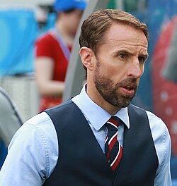
- Gareth Southgate, former England football player, former England manager (2016–2024), reached 2018 FIFA World Cup semi-final and two Euro finals, losing both.[286][287]
- Daley Thompson, athlete, winner of two Decathlon Olympic gold medals, trained in Crawley for the Olympics in 1980 and 1984.[288]
- Peter Vaughan, actor, Straw Dogs (1971), Grouty in Porridge (1979) and Maester Aemon Targaryen in Game of Thrones (2011–2015),[289] lived in Crawley between 1966-1985[290]
- Dan Walker, BBC breakfast presenter, former sports presenter, born and raised in Crawley.[291]
- The Cure were formed in Crawley in 1976 by Robert Smith, Michael Dempsey and Lol Tolhurst, all of whom attended St Wilfrid's RC School.[292]
- The Feeling's drummer Paul Stewart, guitarist Kevin Jeremiah and keyboard player Ciaran Jeremiah were also at St Wilfrid's.[293]
- Brett Marvin and the Thunderbolts were formed in Crawley in 1968 at the Thomas Bennett School.[294]
See also
[edit]Notes
[edit]References
[edit]- ^ a b UK Census (2021). "2021 Census Area Profile – Crawley Local Authority (E07000226)". Nomis. Office for National Statistics. Retrieved 5 January 2024.
- ^ a b Gwynne 1990, p. 9.
- ^ Brandon 2003
- ^ a b c d "Select Committee on Transport, Local Government and the Regions: Appendices to the Minutes of Evidence. Supplementary memorandum by Crawley Borough Council (NT 15(a))". United Kingdom Parliament Publications and Records website. The Information Policy Division, Office of Public Sector Information. 2002. Archived from the original on 17 July 2019. Retrieved 2 April 2008.
- ^ a b "Top 10: Europe's Busiest Airports". OAG Aviation Worldwide Limited. 2 April 2025. Archived from the original on 13 May 2025. Retrieved 18 July 2025.
- ^ a b "West and North West of Crawley". Horsham District Council & Crawley Borough Council. 2006–2009. Archived from the original on 6 December 2007. Retrieved 29 October 2009.
- ^ "Forced into exile: the Chagossians scattered in Mauritius and Britain". The Guardian. 7 October 2024. Retrieved 4 February 2025.
- ^ a b c d e "A Brief History of Crawley". Crawley Borough Council website. Crawley Borough Council. 2007. Archived from the original on 28 September 2007. Retrieved 31 July 2007.
- ^ Cole 2004a, p. 10.
- ^ "About The High Weald: The Iron Story". High Weald AONB Unit website. High Weald AONB Unit. 2008. Archived from the original on 7 August 2007. Retrieved 2 April 2008.
- ^ "Life in Late Iron Age Sussex: Trade & Industry". Romans in Sussex website. The Sussex Archaeological Society. 2008. Archived from the original on 6 September 2008. Retrieved 2 April 2008.
- ^ "Life in Roman Sussex: Crafts & Industry: Weald Iron Industry". Romans in Sussex website. The Sussex Archaeological Society. 2008. Archived from the original on 11 September 2007. Retrieved 2 April 2008.
- ^ a b Harris, Roland B. (2003). "The Making of the High Weald". High Weald AONB. Retrieved 18 May 2020.
- ^ Cole 2004a, p. 14.
- ^ "Crawley Borough Council: St Nicholas Church". Crawley Borough Council website. Crawley Borough Council. 2008. Archived from the original on 27 September 2006. Retrieved 28 March 2007.
- ^ Salzman, L. F., ed. (1940). "A History of the County of Sussex: Volume 7 – The Rape of Lewes. Parishes: Crawley". Victoria County History of Sussex. British History Online. pp. 144–147. Archived from the original on 8 January 2015. Retrieved 30 October 2009.
- ^ "Crawley Borough Council: St Margaret's Church". Crawley Borough Council website. Crawley Borough Council. 2008. Archived from the original on 27 September 2006. Retrieved 28 March 2007.
- ^ a b c d e f Cole 2004b, Unpaginated.
- ^ Gwynne 1990, p. 98.
- ^ Cole 2004a, p. 56.
- ^ s.n. 1839, p. 681.
- ^ "Crawley High Street". Crawley Borough Council website. Crawley Borough Council. 2007. Retrieved 3 August 2007.
- ^ a b "Crawley Town Walk" (PDF). Crawley Borough Council website. Crawley Borough Council. 2007. Retrieved 3 August 2007.
- ^ "Detailed record: The George Hotel, High Street (west side), Crawley, Crawley, West Sussex". Images of England. English Heritage. 2007. Retrieved 29 October 2009.
- ^ "Diocese of Chichester: St John the Baptist, Crawley". A Church Near You website. Oxford Diocesan Publications Ltd. 2007. Retrieved 13 September 2007.
{{cite web}}: CS1 maint: deprecated archival service (link) - ^ Hudson, T.P. (Ed) (1940). "Parishes: Crawley". A History of the County of Sussex: Volume 7: The Rape of Lewes. British History Online. Archived from the original on 25 May 2011. Retrieved 13 September 2007.
- ^ "St John the Baptist Parish Church, Crawley, West Sussex – 22nd April 2004". The Roughwood website. Mark Collins. 2007. Archived from the original on 8 July 2008. Retrieved 12 March 2008.
- ^ "Dove Details". Dove's Guide for Church Bell Ringers website. Sid Baldwin, Ron Johnston and Tim Jackson on behalf of the Central Council of Church Bell Ringers. 24 February 2008. Archived from the original on 16 October 2015. Retrieved 12 March 2008.
- ^ David Palmer (2003). "A brief history of Maidenbower" (PDF). Maidenbower Village website. Stuart Cummings. Archived from the original (PDF) on 27 September 2007. Retrieved 6 September 2007.
- ^ a b c Gray 1983, p. 9.
- ^ Hudson, T.P. (Ed) (1987). "Ifield: Economic History". A History of the County of Sussex: Volume 6 Part 3. British History Online. Archived from the original on 25 May 2011. Retrieved 3 March 2008.
- ^ Gwynne 1990, p. 119.
- ^ Cole 2004a, p. 62.
- ^ a b c "Crawley District: Total Population". A Vision of Britain Through Time website. National Statistics. 2001. Archived from the original on 1 October 2007. Retrieved 2 August 2007.
- ^ Gwynne 1990, p. 146.
- ^ Gray 1983, pp. 11–12.
- ^ "No. 37849". The London Gazette. 10 January 1947. p. 231.
- ^ "Cataloguing Crawley New Town: The Team Behind the Corp". West Sussex Record Office. 8 May 2023. Retrieved 30 September 2023.
- ^ a b c d e f Hudson, T.P. (Ed) (1987). "Crawley New Town". A History of the County of Sussex: Volume 6 Part 3: Bramber Rape (North-Eastern Part) including Crawley New Town. British History Online. Archived from the original on 28 September 2007. Retrieved 31 July 2007.
- ^ a b "New Town History". Crawley Borough Council website. Crawley Borough Council. 2005. Archived from the original on 16 December 2018. Retrieved 10 March 2020.
- ^ a b c Bennett, Thomas P. (January 1961). "Crawley after Thirteen Years". Town & County Planning. XXIX (I): 18–20.
- ^ "First proposed structure plan, 1947". Nostalgia: A Crawley Observer Supplement (2): 3. 1995.
- ^ The Crawley Development Corporation's Master Plan for Crawley New Town (Map). Crawley Development Corporation. 1949.
- ^ a b c d e Hudson, T.P. (Ed) (1987). "Growth of the New Town". A History of the County of Sussex: Volume 6 Part 3: Bramber Rape (North-Eastern Part) including Crawley New Town. Victoria County History. Archived from the original on 27 September 2007. Retrieved 7 August 2007.
- ^ Treagus, Janet (15 May 2007). "Council wins fight against new neighbourhood". Crawley Borough Council. Archived from the original on 28 September 2007. Retrieved 21 August 2007.
- ^ "Crawley's New Forge Wood school is officially opened". CrawleyNews24. 23 November 2017. Archived from the original on 18 September 2020. Retrieved 5 April 2020.
- ^ "Forge Wood". Crawley Borough Council. Archived from the original on 22 January 2021. Retrieved 5 April 2020.
- ^ Crawley Borough Council’s Local Development Scheme 2025 to 2028 (PDF) (Report). Crawley Borough Council. February 2025. p. 10. Archived (PDF) from the original on 18 July 2025. Retrieved 18 July 2025.
[Paragraph] 2.16. Crawley is an area within the two-tier local government system. Crawley Borough Council provides the local services for the borough and West Sussex County Council provide the strategic services.
- ^ "Arun joins the Greater Brighton success story". Greater Brighton City Region. 22 October 2019. Retrieved 18 July 2025.
- ^ "The Statutory Instruments Regulations 1947", legislation.gov.uk, The National Archives, 7 February 2019, SI 2019/198, retrieved 18 July 2025
- ^ Dunford, Mark (30 May 2022). "New leader, Cabinet and Mayor appointed at Crawley Borough Council". Sussex Express. National World Publishing Ltd. Archived from the original on 1 September 2022. Retrieved 18 July 2025.
- ^ a b "Crawley Civil Parish / Ancient Parish / Chapelry". A Vision of Britain through Time. GB Historical GIS / University of Portsmouth. Retrieved 10 September 2022.
- ^ Gwynne 1990, p. 165.
- ^ a b "Coat of Arms". Crawley Borough Council website. Crawley Borough Council. 2007. Archived from the original on 28 September 2007. Retrieved 1 September 2007.
- ^ "Past Mayors". Crawley Borough Council website. Crawley Borough Council. 2007. Archived from the original on 11 November 2007. Retrieved 9 April 2008.
- ^ "The English Non-Metropolitan Districts (Definition) Order 1972", legislation.gov.uk, The National Archives, SI 1972/2039, retrieved 10 September 2022
- ^ "Stop the demolition of Crawley Town Hall". 38 Degrees. Archived from the original on 28 May 2021. Retrieved 8 February 2021.
- ^ "SHW appointed on Crawley Town Hall redevelopment". Invest Crawley. 12 June 2020. Archived from the original on 29 November 2020. Retrieved 8 February 2021.
- ^ "Crawley's New Town Hall is officially opened". Sussex World. 22 March 2023. Retrieved 23 April 2023.
- ^ Crawley Borough Council 1997, Unpaginated.
- ^ "Election results for Crawley Constituency". Crawley Borough Council. Archived from the original on 30 November 2024. Retrieved 18 July 2025.
- ^ "Election 2010: Crawley". BBC News. 2010. Archived from the original on 26 December 2024. Retrieved 18 July 2025.
- ^ "Laura Moffatt—Labour Member of Parliament for Crawley". Official website of Laura Moffatt MP. The Labour Party. 2008. Archived from the original on 19 April 2008. Retrieved 1 April 2008.
- ^ "Laura Moffatt". The Guardian. London Politics website: Guardian News and Media Ltd. 2008. Archived from the original on 18 February 2007. Retrieved 1 April 2008.
- ^ "10 things about the election". BBC News Website: Election 2005. 6 May 2005. Archived from the original on 22 January 2021. Retrieved 31 July 2007.
- ^ Walker, Amy (29 August 2024). "'Continuing failings' at Brook House after inquiry". BBC News. Archived from the original on 25 November 2024. Retrieved 18 July 2025.
- ^ Office for National Statistics (2001). "Census 2001: Key Statistics for urban areas in the South East; Map 3" (PDF). statistics.gov.uk. Archived from the original (PDF) on 24 March 2009. Retrieved 17 April 2008.
- ^ "Crawley Manor Royal: Final Report" (PDF). Crawley Borough Council/BDP/Regeneris Final Report on Manor Royal Industrial Estate. Crawley Borough Council, Building Design Partnership (BDP) and Regeneris Consulting Ltd. May 2008. p. 11. Archived from the original (PDF) on 5 February 2009. Retrieved 3 December 2008.
- ^ Harris, Roland B. (December 2008). "Crawley - Historic Character Assessment Report, Sussex Extensive Urban Survey (EUS)" (PDF) (PDF).
- ^ Lowerson 1980, p. 3.
- ^ "Geology of Surrey and Sussex, after Woodward (1904), based on Reynolds (1860; 1889)". Geology of Great Britain—an Introduction with Geological Maps (from the website of Southampton University). Ian West and Tonya West. 2008. Archived from the original on 28 May 2008. Retrieved 1 April 2008.
- ^ a b Gwynne 1990, pp. 3–4.
- ^ "Ifield Mill Pond". Crawley Borough Council website. Crawley Borough Council. 2007. Archived from the original on 28 September 2007. Retrieved 10 August 2007.
- ^ "The Weald to Waves Corridor: Interactive Map". Weald to Waves. 2025. Retrieved 18 July 2025.
- ^ Thomson, Keith Stewart (March–April 2006). "American Dinosaurs: Who and What Was First". American Scientist. 94 (2): 209. doi:10.1511/2006.58.209.
- ^ "The Discovery of Hylaeosaurus, 1833". The Linda Hall Library, Kansas City website. Linda Hall Library. 2003. Archived from the original on 8 May 2008. Retrieved 1 April 2008.
- ^ "Station: Charlwood". Met Office. 2025. Archived from the original on 18 July 2025. Retrieved 18 July 2025.
- ^ "July 2006". Archived from the original on 29 June 2011. Retrieved 25 February 2011.
- ^ "July 2006". Archived from the original on 24 July 2011. Retrieved 25 February 2011.
- ^ "August 2003". Archived from the original on 24 July 2011. Retrieved 25 February 2011.
- ^ "August 2003". Archived from the original on 24 July 2011. Retrieved 25 February 2011.
- ^ "1971-00 Normals". Archived from the original on 24 July 2011. Retrieved 25 February 2011.
- ^ "1971-00 Normals". Archived from the original on 24 July 2011. Retrieved 25 February 2011.
- ^ Rogers, Simon (21 December 2010). "December 2010". The Guardian. London. Archived from the original on 9 January 2021. Retrieved 25 February 2011.
- ^ "December 2010". Archived from the original on 24 July 2011. Retrieved 25 February 2011.
- ^ "Annual average minimum". Archived from the original on 24 July 2011. Retrieved 25 February 2011.
- ^ "Annual average frost". Archived from the original on 24 July 2011. Retrieved 25 February 2011.
- ^ "Wet days 1971-00". Archived from the original on 24 July 2011. Retrieved 25 February 2011.
- ^ "Climate Normals 1971–2000". YR.NO. Archived from the original on 17 November 2018. Retrieved 25 February 2011.
- ^ "Climate Normals 1961–1990". NOAA (FTP). Retrieved 25 February 2011.[dead ftp link] (To view documents see Help:FTP)
- ^ "Crawley Borough Council: Crawley's Neighbourhoods". Crawley Borough Council website. Crawley Borough Council. 2008. Archived from the original on 2 August 2008. Retrieved 2 April 2008.
- ^ "Crawley Baseline Character Assessment" (PDF). EDAW/AECOM. May 2009. p. 24. Archived (PDF) from the original on 8 June 2011. Retrieved 9 March 2010.
- ^ a b c d e f g h i j k l m n Hudson, T.P. (Ed) (1987). "Crawley New Town: Economic History". A History of the County of Sussex: Volume 6 Part 3: Bramber Rape (North-Eastern Part) including Crawley New Town. British History Online. Archived from the original on 27 September 2007. Retrieved 3 July 2007.
- ^ "Neighbourhood Statistics". National Statistics website. Office for National Statistics. 2007. Archived from the original on 7 May 2017. Retrieved 7 August 2007.
- ^ Street Plan of Crawley (Map). 5.6" = 1-mile. Cartography by Ordnance Survey. G.I. Barnett & Sons Ltd. 1970.
- ^ Hudson, T. P., ed. (1987). "A History of the County of Sussex: Volume 6 Part 3 – Bramber Rape (North-Eastern Part) including Crawley New Town. Crawley New Town: Growth of the New Town". Victoria County History of Sussex. British History Online. pp. 75–81. Retrieved 5 January 2026.
- ^ Historic England. "Church of St Michael and All Angels, Church Road (Grade II*) (1187081)". National Heritage List for England. Retrieved 18 July 2025.
- ^ Gwynne 1990, p. 170.
- ^ Sheet 187: Dorking, Reigate and Crawley (Map). 1:50,000. Landranger Series of Great Britain. Ordnance Survey. 1980.
- ^ Hudson, T. P., ed. (1987). "A History of the County of Sussex: Volume 6 Part 3 – Bramber Rape (North-Eastern Part) including Crawley New Town. Crawley New Town". Victoria County History of Sussex. British History Online. pp. 74–75. Retrieved 6 January 2026.
- ^ Salzman, L. F., ed. (1940). "A History of the County of Sussex: Volume 7 – The Rape of Lewes. Parishes:Worth". Victoria County History of Sussex. British History Online. pp. 192–200. Archived from the original on 8 January 2015. Retrieved 12 January 2010.
- ^ Aitch, Iain (4 April 2009). "Event preview: British And World Marbles Championship, Tinsley Green". The Guardian. UK: Guardian News and Media Ltd. Archived from the original on 3 March 2014. Retrieved 13 January 2010.
- ^ "Planning Application No. CR/1998/0039/OUT". Crawley Borough Council planning application. Crawley Borough Council. 21 January 1998. Archived from the original on 8 June 2011. Retrieved 13 January 2010.
- ^ Bird, Philip; Moore, Joe; Mulcock, John (6 January 1969). "How horror came from the sky at 2.35 am". Evening Argus (incorporating Sussex Daily News). No. Special Extra Edition. Brighton. p. 12.
- ^ "Surrey Constabulary – Part 3: Policing Change 1951–1975. Airliner crashes on approach to Gatwick Airport 1969". The Open University International Centre for the History of Crime, Policing and Justice. Open University and Robert Bartlett. 2013. Archived from the original on 31 October 2014. Retrieved 26 February 2013.
- ^ Review of non-Metropolitan counties: County of West Sussex and its Boundary with Surrey (PDF). LGBCE Report No. 589 (Report). Local Government Boundary Commission for England. 26 April 1990. §§. 23, 66. Archived from the original (PDF) on 17 October 2013. Retrieved 16 March 2013.
- ^ Review of non-Metropolitan counties: County of West Sussex and its Boundary with Surrey (PDF). LGBCE Report No. 589 (Report). Local Government Boundary Commission for England. 26 April 1990. Map 10. Archived from the original (PDF) on 17 October 2013. Retrieved 19 March 2013.
- ^ Kelly, G.M. (7 January 1969). Civil Aircraft Accident Report No. EW/C/303: Report on the Accident to Boeing 727-112C YA-FAR 1.5 miles east of London (Gatwick) Airport on 5th January 1969 (Report). Her Majesty's Stationery Office. Archived from the original on 7 September 2012. Retrieved 26 February 2013.
- ^ "Horsham District: Total Population". A Vision of Britain Through Time website. National Statistics. 2001. Archived from the original on 22 January 2021. Retrieved 2 August 2007.
- ^ "Key Figures for 2011 Census: Key Statistics". Neighbourhood Statistics website. National Statistics. 2011. Archived from the original on 23 March 2017. Retrieved 22 March 2017.
- ^ "Crawley: Number of usual residents in households and communal establishments (TS001)". 2021 United Kingdom census data. CensusData.uk and Office for National Statistics. 2023. Archived from the original on 28 January 2024. Retrieved 18 July 2025.
- ^ "West Sussex: Number of usual residents in households and communal establishments (TS001)". 2021 United Kingdom census data. CensusData.uk and Office for National Statistics. 2023. Archived from the original on 18 July 2025. Retrieved 18 July 2025.
- ^ "Census Maps - Census 2021 data interactive, ONS". www.ons.gov.uk. Retrieved 9 September 2023.
- ^ "Ethnic Group (UV09) dataset". Neighbourhood Statistics website. National Statistics. 2001. Archived from the original on 6 December 2007. Retrieved 2 August 2007.
- ^ "Crawley: Ethnic group (detailed)". censusdata.uk. Retrieved 9 September 2023.
- ^ "Crawley: Main language (detailed)". censusdata.uk. Retrieved 9 September 2023.
- ^ "Tamil Learning Centre". Macroid App Services Pvt Ltd. 2025. Archived from the original on 17 June 2025. Retrieved 18 July 2025.
- ^ "Chagos Islanders will not be allowed home, UK government says". BBC News. 16 November 2016. Archived from the original on 24 October 2016. Retrieved 16 November 2016.
- ^ "Helping the 'exiled and ignored' Chagossians". Crawley and Horley Observer. 17 January 2018. Archived from the original on 8 September 2018. Retrieved 8 September 2018.
- ^ "Population density - Census Maps, ONS". www.ons.gov.uk. Retrieved 9 September 2023.
- ^ "National statistics socio economic classification ns sec - Census Maps, ONS". www.ons.gov.uk. Retrieved 9 September 2023.
- ^ "Crawley: Highest level of qualification". censusdata.uk. Retrieved 9 September 2023.
- ^ "Crawley: Religion (TS030)". 2021 United Kingdom census data. CensusData.uk and Office for National Statistics. 2023. Archived from the original on 28 January 2024. Retrieved 28 January 2024.
- ^ Historic England. "Parish Church of St John the Baptist, High Street (Grade II*) (1298875)". National Heritage List for England. Retrieved 18 July 2025.
- ^ Historic England. "Parish Church of St Margaret, The Street (Grade I) (1187108)". National Heritage List for England. Retrieved 18 July 2025.
- ^ Historic England. "The Parish Church of St Nicholas, Church Road (Grade I) (1187114)". National Heritage List for England. Retrieved 18 July 2025.
- ^ Hudson, T. P., ed. (1987). "A History of the County of Sussex: Volume 6 Part 3 – Bramber Rape (North-Eastern Part) including Crawley New Town. Ifield – Protestant Nonconformity". Victoria County History of Sussex. British History Online. pp. 71–72. Retrieved 7 December 2008.
- ^ Historic England. "Friends' Meeting House, Langley Lane (Grade I) (1298879)". National Heritage List for England. Retrieved 18 July 2025.
- ^ Hudson, T. P., ed. (1987). "A History of the County of Sussex: Volume 6 Part 3 – Bramber Rape (North-Eastern Part) including Crawley New Town. Crawley New Town: Other Religions". Victoria County History of Sussex. British History Online. p. 93. Retrieved 30 January 2013.
- ^ "Langley Green church converts to new mosque". Crawley News/thisiscrawley.co.uk website. East Surrey & Sussex News and Media Ltd. 18 April 2012. Archived from the original on 23 December 2015. Retrieved 29 January 2013.
- ^ "History of GHU – The Journey". Gurjar Hindu Union (Apple Tree Centre). 2012. Archived from the original on 12 August 2013. Retrieved 30 January 2013.
- ^ "Faith, Belief & Culture Guide" (PDF). Crawley Borough Council Faith, Belief and Culture Guide. Crawley Borough Council and Crawley Interfaith Network. October 2008. Archived (PDF) from the original on 4 March 2016. Retrieved 29 January 2013.
- ^ "Temple on target as specialist stonemasons flown in". Crawley Observer. Johnston Press Digital Publishing. 25 September 2009. Archived from the original on 29 July 2012. Retrieved 30 January 2013.
- ^ Baldock, Stacia (8 June 2007). "New Hindu temple for Langley Green". Crawley Observer. Johnston Press Digital Publishing. Archived from the original on 29 July 2012. Retrieved 30 January 2013.
- ^ "Labour Market Profile: Crawley". Nomis official labour market statistics. Office for National Statistics. Archived from the original on 17 July 2011. Retrieved 2 August 2007. Data is taken from the ONS annual business inquiry employee analysis and refers to 2005
- ^ "The Gatwick Diamond". Gatwick Diamond website. West Sussex Economic Partnership. 2007. Archived from the original on 8 June 2007. Retrieved 2 August 2007.
- ^ "Unemployment". Crawley Economic Profile 2004. Crawley Borough Council. 2004. Archived from the original (PDF) on 28 September 2007. Retrieved 2 August 2007.
- ^ "Debates for 9 Feb 1989". House of Commons Hansard. HMSO. 1989. Archived from the original on 28 June 2009. Retrieved 6 January 2007.
- ^ Partington, Richard (16 April 2020). "Crawley likely to be worst affected by UK coronavirus job losses". The Guardian. Archived from the original on 11 June 2020. Retrieved 11 June 2020.
- ^ a b c Gray 1983, p. 16.
- ^ a b c Bennett 1949, p. 31.
- ^ a b Gray 1983, p. 33.
- ^ Gray 1983, p. 34.
- ^ "Thales opens new Crawley site in lifeline for town business". Crawley News. Reigate, Surrey: East Surrey and Sussex News and Media. 20 October 2008. ISSN 0961-480X. Retrieved 30 October 2009.
{{cite news}}: CS1 maint: deprecated archival service (link) - ^ "NHS: West Sussex PCT". NHS Choices: West Sussex PCT (list of sites). Department of Health. 2007. Archived from the original on 26 September 2007. Retrieved 5 September 2007.
- ^ "Locallife Crawley". Locallife Crawley: Business directory. Locallife Ltd. 2007. Archived from the original on 27 September 2007. Retrieved 5 September 2007.
- ^ "Contacts Europe". Doosan Babcock. 2009. Archived from the original on 12 March 2010. Retrieved 29 October 2009.
- ^ "Regions, WesternGeco". Schlumberger Ltd. 2009. Archived from the original on 1 June 2009. Retrieved 29 October 2009.
- ^ "Our Offices Around the World". Virgin Atlantic Ltd. 2009. Archived from the original on 9 February 2010. Retrieved 29 October 2009.
- ^ "William Reed Business Media". Archived from the original on 22 September 2012. Retrieved 19 September 2012.
- ^ Nicholls, David (5 September 2014). "Video: Toast of the Nation: how Dualit became makers of the ultimate design classic". The Daily Telegraph. Archived from the original on 22 September 2018. Retrieved 2 December 2018.
- ^ "Company celebrates 90 years of providing insulin to diabetics". Crawley Observer. Johnston Publishing Ltd. 5 March 2013. Archived from the original on 3 November 2013. Retrieved 6 March 2013.
- ^ Sukhraj, Penny. "BDO Bromley moves to Gatwick Archived 13 January 2012 at the Wayback Machine." Accountancy Age. 29 January 2007. Retrieved on 12 February 2011.
- ^ "Nestlé in the UK & Ireland Locations". Archived from the original on 6 September 2019. Retrieved 6 September 2019.
- ^ "Website Terms and Conditions Archived 18 September 2008 at the Wayback Machine." TUI UK. Retrieved on 2 January 2011. "TUI UK Limited ("TUI UK") trades under a number of brands including Thomson, and has its Registered Office at TUI Travel House, Crawley Business Quarter, Fleming Way, Crawley, West Sussex, RH10 9QL."
- ^ "Booking Conditions Archived 19 January 2012 at the Wayback Machine." Thomson Airways. Retrieved on 4 February 2011."Both Thomson Airways and TUI UK Limited have their Registered Office at TUI Travel House, Crawley Business Quarter, Fleming Way, Crawley RH10 9QL[...]"
- ^ "British Airways Holidays: Booking terms and conditions". British Airways Holidays Ltd. 2007. Archived from the original on 12 August 2007. Retrieved 5 September 2007.
- ^ "About Airmiles". AIRMILES Travel Promotions Ltd, trading as AIRMILES. 2008. Archived from the original on 14 October 2007. Retrieved 21 March 2008.
- ^ "Contacts." Astraeus Airlines. Retrieved on 22 May 2010.
- ^ "World Airline Survey ..." Flight International: 564. 10 April 1969. Archived from the original on 4 February 2012. Retrieved 13 February 2011. "Head Office: Gatwick Airport, Horley. Surrey."
- ^ "World Airline Directory." Flight International. 24–30 March 1999. 64 Archived 4 February 2012 at the Wayback Machine.
- ^ "Contact Us." CP Ships. 4 November 2005. Retrieved on 12 February 2011. "CP Ships Limited 2 City Place Beehive Ring Road Gatwick, West Sussex RH6 0PA, United Kingdom"
- ^ Dennis, Juliet. "Management structure of Thomson and First Choice shops merged Archived 22 April 2012 at the Wayback Machine." Travel Weekly. 6 January 2009. Retrieved on 4 January 2011.
- ^ "The Beehive." GB Airways. Retrieved on 19 May 2009.
- ^ "World Airline Directory." Flight International. 16 May 1981. 1444 Archived 4 February 2012 at the Wayback Machine.
- ^ World Airline Directory. Flight International. 20 March 1975. 505 Archived 4 February 2012 at the Wayback Machine. "Head Office: Gatwick Airport, Horley, Surrey."
- ^ "World Airline Directory." Flight International. 14–20 March 1990. 55 Archived 4 February 2012 at the Wayback Machine. "Head Office: The Galleria, Station Road, Crawley, West Sussex RH10 1HY, England"
- ^ "Reputedly haunted hotels and inns". English Inns. Archived from the original on 29 December 2010. Retrieved 14 August 2010.
- ^ Gray 1983, p. 39.
- ^ "Propertymall.com: Crawley, County Mall Shopping Centre". www.propertymall.com. MaxiMalls.com Ltd. 2007. Archived from the original on 28 September 2007. Retrieved 5 September 2007.
- ^ a b Nathaniel, Raman; Chamier, James (4 April 1990). "TC6 Centre to open in 1992!". Crawley and District Observer. Crawley. p. 61. Retrieved 17 November 2025 – via British Newspaper Archive.
- ^ Christine Ease (25 February 2005). "The magnetic North". www.propertyweek.com. Property Week. Archived from the original on 27 September 2007. Retrieved 21 August 2007.
- ^ Fryett, David (30 October 1991). "Jobless total hits new peak". Crawley News. Crawley. p. 12. Retrieved 17 November 2025 – via British Newspaper Archive.
- ^ Fryett, David (23 October 1991). "Job bonanza at new mall". Crawley News. Crawley. p. 10. Retrieved 17 November 2025 – via British Newspaper Archive.
- ^ "Shopping". www.countymall.co.uk. Standard Life Property. 2007. Archived from the original on 8 October 2007. Retrieved 21 August 2007.
- ^ "No. 52400". The London Gazette. 5 April 1990. p. 7453.
- ^ "Town Centre Strategy—Consultation Document" (PDF). Crawley Borough Council website. Crawley Borough Council. 27 April 2005. Archived from the original (PDF) on 28 May 2008. Retrieved 31 March 2008.
- ^ "Town Centre North, Crawley: Retail Assessment" (PDF). Crawley Borough Council website. Grosvenor Investments Ltd. May 2006. Archived from the original (PDF) on 28 September 2007. Retrieved 9 September 2007.
- ^ Bastable 2004, p. 9.
- ^ a b "Policing Your Neighbourhood: Local Policing". Sussex Police website. Sussex Police. 2008. Archived from the original on 10 December 2007. Retrieved 22 February 2008.
- ^ "Sussex Police Online – District Crawley". Sussex Police website. Sussex Police. 2008. Archived from the original on 10 November 2016. Retrieved 22 February 2008.
- ^ "Policing Your Neighbourhood—Local Police Stations". Sussex Police website. Sussex Police. 2008. Archived from the original on 28 February 2008. Retrieved 22 February 2008.
- ^ "West Sussex Fire & Rescue Service: Contacts". West Sussex County Council. 2008. Archived from the original on 5 February 2008. Retrieved 22 February 2008.
- ^ "South East Coast Ambulance Service—About Us". Secamb website. South East Coast Ambulance Service. 2008. Archived from the original on 2 March 2008. Retrieved 22 February 2008.
- ^ "Crawley Hospital General Information". NHS website. National Health Service. 2008. Archived from the original on 12 March 2009. Retrieved 22 February 2008.
- ^ "Mixed marks for South East trusts". BBC News website. 18 October 2007. Archived from the original on 20 October 2007. Retrieved 22 February 2008.
- ^ "Surrey and Sussex Healthcare NHS Trust Crawley Hospital Quality Report" (PDF). Archived (PDF) from the original on 23 September 2015. Retrieved 10 August 2015.
- ^ "Surrey and Sussex Healthcare NHS Trust Quality Report" (PDF). Archived (PDF) from the original on 23 September 2015. Retrieved 10 August 2015.
- ^ "Thames Water Service Area Map". Thames Water website. Thames Water. 2008. Archived from the original (SWF) on 29 February 2008. Retrieved 22 February 2008.
- ^ "National Grid: Distribution Network Operator (DNO) Companies". National Grid website. National Grid. 2008. Archived from the original on 20 February 2012. Retrieved 22 February 2008.
- ^ "National Grid: About the Gas Industry". National Grid website. National Grid. 2008. Archived from the original on 13 February 2008. Retrieved 22 February 2008.
- ^ Hudson, T. P., ed. (1987). "A History of the County of Sussex: Volume 6 Part 3 – Bramber Rape (North-Eastern Part) including Crawley New Town. Crawley New Town: Public services". Victoria County History of Sussex. British History Online. pp. 89–91. Retrieved 18 February 2008.
- ^ Green & Allen 1993
- ^ "New Crawley Library to open its doors next week". WSCC Press Release. West Sussex County Council. Retrieved 10 January 2009.[dead link]
- ^ "Bus Services to CAA Safety Regulation Group, Aviation House Archived 1 September 2012 at the Wayback Machine." Civil Aviation Authority. Retrieved on 9 September 2010.
- ^ "Numbering British Roads". Evening Despatch. No. 10025. Birmingham. 23 July 1923. p. 3. Retrieved 17 November 2025 – via British Newspaper Archive.
- ^ "Crawley Baseline Character Assessment" (PDF). EDAW/AECOM. May 2009. p. 11. Archived (PDF) from the original on 8 June 2011. Retrieved 29 October 2009.
- ^ a b Hudson, T.P., ed. (1987). "Crawley New Town: Communications". A History of the County of Sussex: Volume 6 Part 3: Bramber Rape (North-Eastern Part) including Crawley New Town. Victoria County History. Retrieved 17 November 2025.
- ^ Mitchell & Smith 1986a, p. 4.
- ^ Mitchell, Vic; Keith Smith (1986). Southern Main Lines: Crawley to Littlehampton. Midhurst: Middleton Press. p. 4. ISBN 0-906520-34-7.
- ^ Body 1984, p. 75.
- ^ Mitchell & Smith 1986b, p. 15.
- ^ "West Coastway and Arun Valley: London, East Croydon, Gatwick Airport, Arun Valley & Brighton to Hove, Worthing, Littlehampton, Bognor Regis, Chichester, Portsmouth & Southampton" (PDF). Southern timetable booklet 3 (at Southern website). New Southern Railway Ltd. 2007. Archived from the original (PDF) on 24 June 2008. Retrieved 7 April 2008.
- ^ "Brighton Main Line: London, East Croydon, Tonbridge and Redhill to Gatwick Airport, Three Bridges, Crawley and Horsham" (PDF). Southern timetable booklet 2 (at Southern website). New Southern Railway Ltd. 2007. Archived from the original (PDF) on 24 June 2008. Retrieved 7 April 2008.
- ^ a b Kraemer-Johnson & Bishop 2005, pp. 48–55
- ^ "Acquisition of Crawley Depot". Go Ahead Group website. Go Ahead Group. 2001. Archived from the original on 16 January 2009. Retrieved 31 July 2007.
- ^ "Timetables & Route Index". Metrobus Website. Go Ahead Group. 2007. Archived from the original on 9 July 2007. Retrieved 31 July 2007.
- ^ "Fastway: Phase One Service Launched". Fastway, Issue 6. West Sussex County Council. 2003. Archived from the original (PDF) on 27 September 2007. Retrieved 31 July 2007.
- ^ "Fastway information and timetable from 27 August 2005". Fastway leaflet (2005) at West Sussex County Council Roads & Transport website. West Sussex County Council. 2005. Archived from the original on 27 September 2007. Retrieved 5 September 2007.
- ^ V, Manju (13 May 2017). "Now, Mumbai world's busiest airport with only one runway". The Times of India. Archived from the original on 13 May 2017. Retrieved 13 May 2017.
- ^ Gwynne 1990, p. 147.
- ^ Gwynne 1990, p. 160.
- ^ "Our History". BAA Gatwick Airport website. BAA plc. 2006. Archived from the original on 28 September 2007. Retrieved 1 August 2007.
- ^ "The future development of air transport in the UK". Department for Transport website. Department for Transport. 2003. Archived from the original on 5 May 2007. Retrieved 1 August 2007.
- ^ "Worth Way" (PDF). West Sussex County Council. August 2014. Archived (PDF) from the original on 11 August 2024. Retrieved 17 November 2025.
- ^ "Sussex Border Path". The Long Distance Walkers Association. 2025. Archived from the original on 22 May 2024. Retrieved 17 November 2025.
- ^ "Crawley Town Football Club – past and present". Crawley Town Football Club website. 2007. Archived from the original on 17 September 2007. Retrieved 2 August 2007.
- ^ Piercy, James (31 July 2025). "'Energetic & ambitious' - League Two club-by-club preview". BBC Sport. Archived from the original on 5 August 2025. Retrieved 17 November 2025.
- ^ "Albion achieve Tier One status". Brighton & Hove Albion F.C. 13 December 2017. Archived from the original on 13 July 2018. Retrieved 17 November 2025.
- ^ "Welcome To Crawley RFC". Crawley Rugby Football Club website. 2008. Archived from the original on 13 March 2008. Retrieved 17 March 2008.
- ^ "Tilgate Forest Golf Centre". Crawley Borough Council website. 2006. Archived from the original on 19 July 2007. Retrieved 2 August 2007.
- ^ "Crawley Hockey Club home page". Crawleyhockey.org.uk. Archived from the original on 28 August 2013. Retrieved 4 September 2013.
- ^ "Three Bridges CC". England and Wales Cricket Board. Archived from the original on 24 August 2019. Retrieved 25 August 2019.
- ^ "Top 5 Moments of the Season 2018 (#1)". Three Bridges Cricket Club - YouTube. 17 April 2019. Archived from the original on 21 April 2020. Retrieved 25 August 2019.
- ^ a b "End of an era". Crawley Borough Council website. 2005. Archived from the original on 28 September 2007. Retrieved 3 August 2007.
- ^ a b c Baggs, A P; Currie, C R J; Elrington, C R; Keeling, S M; Rowland, A M (1987). Hudson, T.P. (ed.). "Crawley New Town: Social and cultural activities". A History of the County of Sussex: Volume 6 Part 3: Bramber Rape (North-Eastern Part) including Crawley New Town. Victoria County History. pp. 81–83. Archived from the original on 7 January 2015. Retrieved 2 August 2007 – via British History Online.
- ^ "Sports People; Miss Budd Withdraws". The New York Times. 19 April 1984. Archived from the original on 16 October 2013. Retrieved 30 October 2009.
- ^ "K2 Crawley". Crawley Borough Council website. 2007. Archived from the original on 30 August 2007. Retrieved 2 August 2007.
- ^ "Lord Coe opens K2 sports complex". BBC News website. 24 January 2006. Archived from the original on 22 January 2021. Retrieved 3 August 2007.
- ^ "K2 Crawley makes Olympic training camp guide". Crawley Borough Council website. Crawley Borough Council. 3 March 2008. Archived from the original on 15 November 2011. Retrieved 31 March 2008.
- ^ "History of the Hawth". The Hawth, Crawley website. Crawley Borough Council. 2007. Archived from the original on 30 July 2007. Retrieved 2 August 2007.
- ^ Hudson, T.P. (Ed) (1987). "Ifield". A History of the County of Sussex: Volume 6 Part 3: Bramber Rape (North-Eastern Part) including Crawley New Town. Victoria County History. Archived from the original on 28 September 2007. Retrieved 4 August 2007.
- ^ "Leisure and Culture: Young People". Crawley Borough Council website. 2006. Archived from the original on 25 September 2007. Retrieved 4 August 2007.
- ^ "What to expect from Moka". Crawley Observer. 22 October 2012. Archived from the original on 26 August 2018. Retrieved 26 August 2018.
- ^ "WATCH: Demolition work begins on site of former Crawley nightclub - Here is what you need to know". SussexWorld. 27 March 2023. Retrieved 13 January 2025.
- ^ "Sussex Army Cadets". Army Cadets UK. Retrieved 10 September 2023.
- ^ "The Ministry of Defence cadet forces". GOV.UK. 26 May 2021. Retrieved 10 September 2023.
- ^ "Parks and Gardens: Goffs Park". Crawley Borough Council website. Crawley Borough Council. 2007. Archived from the original on 21 October 2007. Retrieved 9 September 2007.
- ^ "Tilgate Park and Nature Centre". Crawley Borough Council website. Crawley Borough Council. 2007. Archived from the original on 17 October 2007. Retrieved 9 September 2007.
- ^ "Crawley Museum Centre". Culture24 website. 2007. Archived from the original on 14 August 2009. Retrieved 2 August 2007.
- ^ "Listed Buildings in Crawley" (PDF). Crawley Borough Council website: Listed Buildings in Crawley. Crawley Borough Council. 2008. Archived from the original (PDF) on 18 November 2007. Retrieved 6 November 2008.
- ^ Crawley Borough Council (November 2010). Crawley Local Building List (PDF) (Report). Crawley Borough Council. Archived from the original on 29 August 2012. Retrieved 10 February 2013.
- ^ "Crowds Welcome London to Brighton Veteran Cars at Crawley". Crawley Observer. 5 November 2018. Archived from the original on 10 November 2018. Retrieved 10 November 2018.
- ^ "Stage two consultation on age of transfer for Crawley schools". Press Releases. West Sussex County Council. 13 January 2002. Archived from the original on 27 September 2007. Retrieved 31 July 2007.
- ^ "Establishments matching 'Crawley'". gov.uk. Government Digital Service. 2025. Retrieved 12 December 2025. (individual links to each school confirm existence of sixth form)
- ^ "Establishment: The Gatwick School". gov.uk. Government Digital Service. 2025. Retrieved 12 December 2025.
- ^ "Adult Educational Centres". West Sussex Grid for Learning. West Sussex County Council. 2007. Archived from the original on 1 July 2007. Retrieved 31 July 2007.
- ^ "Establishments matching 'Crawley'". gov.uk. Government Digital Service. 2025. Retrieved 12 December 2025.
- ^ "Primary school converts to academy status". Crawley Observer. 1 February 2017. Archived from the original on 26 August 2018. Retrieved 26 August 2018.
- ^ "Atelier 21 Future School - government listing". GOV.UK. Archived from the original on 22 January 2021. Retrieved 2 September 2020.
- ^ Hudson, T.P. (Ed) (1987). "Crawley New Town:Further Education". A History of the County of Sussex: Volume 6 Part 3: Bramber Rape (North-Eastern Part) including Crawley New Town. British History Online. Archived from the original on 11 March 2007. Retrieved 31 July 2007.
- ^ "Central Sussex College – A New Era". Central Sussex College website. Central Sussex College. 2005. Archived from the original on 27 September 2006. Retrieved 31 July 2007.
- ^ "Innovative new campus set for Crawley, not Horsham". Bulletin. University of Sussex. 16 June 2004. Archived from the original on 7 September 2007. Retrieved 31 July 2007.
- ^ West Sussex Record Office (2003). "Newspapers in West Sussex" (PDF). Local History Mini-guide to Sources No. 8. West Sussex County Council. Archived from the original (PDF) on 19 January 2012. Retrieved 31 August 2007.
- ^ Snoddy, Ray (18 June 2021). "Ditching the generic". InPublishing Ltd. Archived from the original on 18 September 2024. Retrieved 28 November 2025.
- ^ Sweney, Mark (28 October 2015). "Trinity Mirror confirms £220m Local World deal". The Guardian. Archived from the original on 25 August 2016. Retrieved 26 October 2016.
- ^ "Trinity Mirror to close Crawley News next week - Journalism News from HoldtheFrontPage". HoldTheFrontPage. Archived from the original on 26 October 2016. Retrieved 26 October 2016.
- ^ "Crawley Times". Johnston Press. 2008. Archived from the original on 13 January 2009. Retrieved 4 January 2009.
- ^ "Transmitters". UK Free TV website. UK Free TV. 2007. Retrieved 31 March 2008.[permanent dead link]
- ^ GCap Media plc (2008). "Information about Mercury FM". Mercury FM website. Archived from the original on 22 January 2021. Retrieved 31 March 2008.
- ^ Plunkett, John (21 June 2010). "Global Radio to halve number of local Heart stations". The Guardian. Archived from the original on 1 September 2025. Retrieved 28 November 2025.
- ^ "Heart slims but strengthens". Radio Today. 21 June 2010. Archived from the original on 26 June 2010. Retrieved 28 November 2025.
- ^ Berger & LaPorte 2010, p. 115.
- ^ Ian Miller (24 August 2006). "Crawley Town Twinning". Crawley Observer.
- ^ "Tarptautinis bendradarbiavimas" (in Lithuanian). Alytaus miesto savivaldybė. Retrieved 17 November 2025.
- ^ "Simon Calder: Let the train take the blame". The Independent. Retrieved 3 January 2025.
- ^ "Mr Cordingley's Recovery". West Sussex County Times and Standard. 23 February 1934. p. 3.
- ^ "Former County Cricketer Dies". West Sussex Gazette. 3 May 1945. p. 2.
- ^ "Honorary Degree Citation: The Hon Sir Charles Walter Michael Court" (PDF). Murdoch University website. 22 March 1995. Archived (PDF) from the original on 28 May 2008. Retrieved 31 March 2008.
- ^ O'Carroll, Isabelle (10 July 2024). "To Macedonia with Love — Spasia Dinkovski's Mystic Burek". Pellicle. Retrieved 20 December 2025.
- ^ "Stars of Tomorrow Erin Doherty - Actor". screendaily.com. 4 October 2018. Archived from the original on 28 September 2020.
- ^ "Crime Library: John George Haigh". Turner Entertainment Digital Network, Inc. 2007. Archived from the original on 29 August 2007. Retrieved 30 August 2007.
- ^ "Commons Chamber - Tuesday 23 May 1950 - Hansard - UK Parliament". hansard.parliament.uk. Retrieved 29 September 2021.
- ^ "Timothy Innes". amazon.co.uk. Retrieved 4 February 2025.
- ^ "Artist: Bethan Leadley". ukfestivalguides.com. Archived from the original on 22 January 2021. Retrieved 3 September 2020.
- ^ MacLaine, Dominic (2004). "Jeffes, Simon Harry Piers". Oxford Dictionary of National Biography (online ed.). Oxford University Press. doi:10.1093/ref:odnb/68826. Retrieved 28 November 2014. (Subscription, Wikipedia Library access or UK public library membership required.)
- ^ "J. Maguire-Drew". Soccerway. Perform Group. Retrieved 20 August 2017.
- ^ "Crawley Boxing Club History". crawleyboxingclub.co.uk. Archived from the original on 18 February 2020. Retrieved 31 August 2020.
- ^ "Champions Evening at the JW Marriott Orlando Bonnet Creek". anightinmyshoes.com. Archived from the original on 19 August 2021. Retrieved 19 August 2021.
- ^ "NHS chief hands over at hospital - Moffatt MP former nurse". theargus.co.uk. 14 February 2005. Archived from the original on 22 January 2021. Retrieved 31 August 2020.
- ^ "Kevin Muscat". CNN/Sports Illustrated (an AOL Time Warner company). 2001. Archived from the original on 28 February 2004. Retrieved 30 August 2007.
- ^ "Natasha Pyne". filmow.com. Archived from the original on 12 December 2013. Retrieved 31 August 2020.
- ^ "Natasha Pyne". classicmoviehub.com. Archived from the original on 18 November 2020. Retrieved 31 August 2020.
- ^ "Maths teacher swaps classroom for comedy and wins top award". Crawley Observer. Johnston Publishing Ltd. 4 March 2013. Archived from the original on 22 February 2018. Retrieved 22 February 2018.
- ^ Hazelwick School (2020). "Hazelwick School Newsletter". Hazelwick School.
- ^ Shemilt, Stephan (10 June 2018). "World Cup: The real Gareth Southgate, by those who know him best". BBC News. Archived from the original on 10 June 2018. Retrieved 11 June 2018.
- ^ "Southgate plans a party". The Argus. Newsquest Media Group. 12 November 1999. Archived from the original on 29 September 2007. Retrieved 30 August 2007.
- ^ "House of Commons Hansard Debates for 21 Jul 2005 (pt 27)". United Kingdom Parliament website: Hansard (House of Commons Daily Debates). The Information Policy Division, Office of Public Sector Information. 21 July 2005. Archived from the original on 27 June 2009. Retrieved 17 March 2008.
- ^ "Game of Thrones and Porridge star Peter Vaughan dies at 93". news.sky.com. 6 December 2016. Archived from the original on 31 October 2020. Retrieved 31 August 2020.
- ^ Page, Sarah (10 April 2017). "Legendary actor to be immortalised at Sussex pub". West Sussex County Times. Retrieved 15 February 2019.
- ^ "Dan Walker - My Crawley". Crawley TV (Youtube). 2016.
- ^ "BBC h2g2: The Cure". BBC. 12 August 2005. Archived from the original on 18 December 2007. Retrieved 30 August 2007.
- ^ "Feeling Their Way to Number One". Crawley News. Reigate, Surrey: East Surrey and Sussex News and Media. 20 February 2008. p. 10. ISSN 0961-480X. Archived from the original on 30 October 2015. Retrieved 20 February 2008.
- ^ "Jim Pitts dies". Thisissussex.co.uk. Retrieved 16 October 2019.
{{cite web}}: CS1 maint: deprecated archival service (link)
Bibliography
[edit]- Bastable, Roger (2004). Crawley. Then & Now. Stroud: Tempus Publishing. ISBN 978-0-7524-3063-8. OCLC 53242919.
- Bennett, Thomas P. (1949). New Towns Act 1946: Reports of the Aycliffe, Crawley, Harlow, Hatfield, Hemel Hempstead, Peterlee, Stevenage and Welwyn Garden City Development Corporations for period ending 31 March 1949. Crawley Development Corporation: Second Annual Report (Report). Her Majesty's Stationery Office. OCLC 52186166.
- Berger, Stefan; LaPorte, Norman (2010). Friendly Enemies: Britain and the GDR, 1949–1990. Berghan Books. ISBN 978-1-84545-697-9.
- Body, Geoffrey (1984). Railways of the Southern Region. PSL Field Guide. Cambridge: Patrick Stephens. ISBN 978-0-85059-664-9. OCLC 11496293.
- Brandon, Peter (2003). The Kent and Sussex Weald. Chichester: Phillimore & Company. ISBN 1-86077-241-2.
- Cole, Belinda (2004a). Crawley: A History and Celebration of the Town. Salisbury: Frith Book Company. ISBN 978-1-904938-19-4. OCLC 59137480.
- Cole, Belinda (2004b). Crawley: An Illustrated Miscellany. Salisbury: Frith Book Company. ISBN 978-1-904938-74-3. OCLC 59137646.
- Crawley Borough Council (1997). Crawley: Official Guide. Wallington: Local Authority Publishing Co Ltd.
- Gray, Fred, ed. (1983). Crawley: Old Town, New Town. Occasional Papers (University of Sussex, Centre for Continuing Education), no. 18. Falmer: University of Sussex. ISBN 978-0-904242-21-8. OCLC 16599642.
- Green, Jeffrey; Allen, Peter (1993). Crawley New Town in old photographs. Stroud: Alan Sutton Publishing. ISBN 978-0-7509-0472-8. OCLC 30026985.
- Gwynne, Peter (1990). A History of Crawley. Chichester: Phillimore & Company. ISBN 978-0-85033-718-1. OCLC 59815249.
- Kraemer-Johnson, Glyn; Bishop, John (2005). Southdown Days. Hersham: Ian Allan Publishing. ISBN 978-0-7110-3077-0. OCLC 60837945.
- Lowerson, John, ed. (1980). Crawley: Victorian New Town. Occasional Papers (University of Sussex, Centre for Continuing Education), no. 12. Falmer: University of Sussex. ISBN 978-0-904242-14-0. OCLC 16563480.
- Mitchell, Vic; Smith, Keith (1986a). Three Bridges to Brighton. Southern Main Lines. Midhurst: Middleton Press. ISBN 978-0-906520-35-2. OCLC 60024136.
- Mitchell, Vic; Smith, Keith (1986b). Crawley to Littlehampton. Southern Main Lines. Midhurst: Middleton Press. ISBN 978-0-906520-34-5. OCLC 60024134.
- s.n. (1839). Pigot's Directory of Sussex. London and Manchester: Pigot & Co. WSC13002. Archived from the original on 11 June 2011. Retrieved 31 March 2008.
External links
[edit]

| International | |
|---|---|
| National | |
| Geographic | |
| Other | |
Crawley
View on GrokipediaThe borough spans approximately 45 square kilometres and recorded a population of 118,500 in the 2021 census, reflecting rapid growth driven by planned development and economic opportunities in aviation and manufacturing.[2]
Gatwick Airport, incorporated into the borough in 1974, serves as a primary economic engine, handling over 46 million passengers annually before the COVID-19 disruptions and anchoring a cluster of logistics, engineering, and service industries that employ a significant portion of the local workforce.[3]
Under the Crawley Development Corporation, the town was master-planned with 14 self-contained neighbourhoods—each featuring housing, schools, shops, and green spaces—to promote balanced urban living while preserving elements of its medieval High Street core.[4]
This structure has contributed to Crawley's status as West Sussex's largest inland settlement, with a diverse economy that includes advanced manufacturing hubs and commuter links to London, though it faces challenges from airport-related noise and infrastructure pressures.[5]
History
Pre-industrial origins
Archaeological evidence points to Iron Age activity in the Crawley area, primarily associated with iron production using local bog iron ore, charcoal from surrounding woodlands, and bloomery furnaces. Sites in Southgate and Broadfield have yielded pottery, refuse ditches, and slag heaps indicative of domestic and industrial settlements.[6][7] This ironworking tradition persisted and expanded during the Romano-British period (c. AD 43–410), with excavations uncovering production sites, associated settlements, and evidence of substantial buildings such as roof-tiled structures in Southgate, likely tied to Roman oversight of Wealden iron resources via roads like the precursor to the London–Brighton route.[8][9] ![St John the Baptist's Church, medieval ecclesiastical structure in Crawley][float-right] Prehistoric ridgeway trackways, such as those linking Pease Pottage to Colgate, traversed the higher ground near Crawley, facilitating seasonal movement and trade alongside Bronze Age burial mounds in the vicinity.[6] The area transitioned to a Saxon agricultural clearing, etymologically "Crāwe lēah" (crows' woodland glade), with the settlement first recorded in 1203 as a minor manor-focused community.[5] Medieval development included moated manor sites, reflecting dispersed rural lordships, and ecclesiastical oversight, as seen in the 13th-century parish records involving parsons like Peter de Wintonia, whose benefice fell under the jurisdiction of the Archbishop of Canterbury's court.[10][11] St John the Baptist Church, originating in the medieval period, served as the focal point for this agrarian parish.[5] By the early 19th century, prior to mechanized transport, Crawley parish remained a small, self-contained rural entity with a population of 210 in 1801, sustained by farming on Wealden clays and residual ironworking in bloomeries and forges.[12] The economy centered on arable and pastoral agriculture, with households engaged in subsistence cropping, livestock rearing, and limited craft production, yielding a population under 1,500 across the broader Ifield-Crawley area by 1841.[12][13]Railway expansion and Victorian development
The extension of the London, Brighton and South Coast Railway's Arun Valley line from Three Bridges to Horsham, which included the opening of Crawley station on 14 February 1848, marked a pivotal shift in the town's connectivity and economic trajectory. This development followed the main line's arrival at Three Bridges in July 1841, transforming the previously isolated rural settlement into a viable commuter outpost for London, approximately 28 miles south. The railway facilitated the transport of goods and passengers, directly enabling local resource extraction and manufacturing without reliance on state intervention.[14][15] Rail infrastructure spurred the growth of brickmaking, leveraging Sussex Weald clay deposits for construction materials demanded by expanding urban centers. By the mid-19th century, brickyards proliferated around Crawley, supplying bricks for local buildings and railway-related projects, contributing to a modest industrial base independent of heavy subsidies. Engineering works also emerged, centered on railway maintenance at Three Bridges depot, which handled locomotive servicing and repairs, attracting skilled labor and fostering ancillary trades like ironworking. These sectors capitalized on the line's operational needs, with no evidence of government-backed incentives driving their establishment.[16][17] Population expansion reflected these causal linkages, rising from approximately 1,400 residents in 1801 to 4,433 by the 1901 census, effectively tripling amid the influx of railway workers, commuters, and industry employees. This growth outpaced pre-rail trends, as improved access to London markets drew middle-class residents seeking affordable housing near the capital, while employment in transport and manufacturing absorbed rural migrants. Unlike later subsidized developments, Victorian Crawley's modernization stemmed from market-driven rail economics, with census data underscoring the correlation between line openings and demographic surges in commuter-adjacent parishes.[18][19]Post-war New Town designation and planning
Crawley was designated a New Town on 9 January 1947 under the provisions of the New Towns Act 1946, which empowered the government to create planned communities for decentralizing London's overcrowded population and addressing post-war housing shortages.[5] The selection followed the Greater London Plan of 1944, targeting areas within commuting distance of the capital, with Crawley's proximity to London (about 30 miles south) and existing railway links making it suitable for overspill relocation. A public inquiry in November 1946 examined the proposal, but it encountered opposition from local stakeholders, including farmers facing land loss, culminating in a legal challenge to the designation order that delayed initial proceedings.[20] This compulsory acquisition authority exemplified state intervention to override local property rights in favor of centralized urban engineering, prioritizing aggregate housing supply over organic settlement patterns. The Crawley Development Corporation, established in February 1947, assumed responsibility for implementation, commissioning architect Anthony Minoprio in June of that year to draft the master plan. Initially envisioning a population of 50,000 accommodated in nine self-contained neighborhoods—each with schools, shops, churches, and recreational facilities—the plan aimed to integrate the historic core with new residential zones while preserving green belts to contain expansion.[21] The target was soon revised upward to approximately 68,000 as demand from London migrants exceeded projections, reflecting the policy's focus on rapid, standardized growth rather than adaptive, demand-driven development. Neighborhoods like Three Bridges and Pound Hill, pre-existing villages, were incorporated and redeveloped to fit this framework, with the plan approved in December 1947.[22] Development accelerated from 1949, starting with West Green as the first new neighborhood, followed by Northgate, Langley Green, Ifield, and expansions into Southgate. The Corporation's approach emphasized prefabricated and terraced housing to meet urgent needs, constructing thousands of units in the 1950s to house incoming workers, often from bombed-out London districts. By the early 1960s, the population had approached 40,000, surpassing early estimates and demonstrating the efficacy of directed planning in scaling infrastructure, though it disrupted traditional rural economies through farmland conversion.[23] This engineered expansion contrasted with historical market-town evolution, where growth typically followed economic clusters without wholesale land redesignation.Late 20th-century growth and expansions
The development of Broadfield neighbourhood commenced in 1969, with Bewbush following in 1974; these additions, larger than earlier districts, accommodated ongoing population influx driven by New Town policies.[22] Crawley's population rose from 62,651 in 1971 to 80,065 in 1981 and reached 93,497 by 1991, reflecting sustained residential expansion amid regional economic pull factors including proximity to Gatwick Airport. Infrastructure supported this growth, including infill developments in existing areas like West Green, where Crawley Hospital opened, and completion of neighbourhood cores through the 1970s and 1980s.[24] In 1983, Crawley's administrative boundaries expanded by 1,800 acres to incorporate adjacent land, marking the transition from central New Town oversight to borough-led management as the designated expansion phase concluded.[5] This de-designation shifted planning authority to Crawley Borough Council, enabling localized adaptations to growth pressures while preserving the town's balanced neighbourhood model. Parallel to residential advances, the Manor Royal industrial estate expanded significantly in the 1980s and 1990s, drawing over 500 firms beyond its original manufacturing focus into diverse operations, bolstered by the estate's strategic location and infrastructure investments.[25] By the late 1990s, this district hosted hundreds of enterprises, contributing to low unemployment rates during the era's economic upswing, though exact firm counts varied with market cycles.[26]Geography and Environment
Location and physical features
Crawley occupies a position in West Sussex, southern England, approximately 28 miles (45 km) south of central London, with geographic coordinates centered at 51°7′N 0°11′W.[27][19] The borough's boundaries cover 17 square miles (44 km²), incorporating minor fringes of the High Weald Area of Outstanding Natural Beauty along its southern edge south of the A264 road.[28][29]Geologically, the area rests on the Weald Clay Formation, a Lower Cretaceous sequence of dark grey mudstones, siltstones, and minor sandstones that form impermeable substrates underlying much of the Weald basin.[30] This clay-dominated geology contributes to the region's characteristic poor natural drainage, exacerbated by urban impervious surfaces. Topographically, Crawley features a relatively flat central plateau at elevations around 80 metres (260 feet) above sea level, with gradual rises to over 150 metres (500 feet) in the southern borough extents, reflecting the undulating margins of the Weald.[31][32] Natural features include remnants of ancient woodland, such as Northgate Parkway, a 2.77-hectare site preserving pre-urban vegetation amid the developed landscape.[33]