
Esplanade
View on Wikipedia

An esplanade or promenade is a long, open, level area, usually next to a river or large body of water, where people may walk. The historical definition of esplanade was a large, open, level area outside fortress or city walls to provide clear fields of fire for the fortress's guns. In modern usage, the space allows the area to be paved as a pedestrian walk; esplanades are often on sea fronts and allow walking whatever the state of the tide, without having to walk on the beach.
History
[edit]In the 19th century, the razing of city fortifications and the relocation of port facilities made it possible in many cities to create promenade paths on the former fortresses and ramparts. The parts of the former fortifications, such as hills, viewpoints, ditches, waterways and lakes have now been included in these promenades, making them popular excursion destinations as well as the location of cultural institutions. The rapid development of artificial street lighting in the 19th century also enabled safe use in the evening. One example of this is Vienna's Ringstrasse.
Esplanades became popular in Victorian times, when it was fashionable to visit seaside resorts. A promenade, often abbreviated to '(the) prom', was an area where people – couples and families especially – would go to walk for a while in order to 'be seen' and be considered part of 'society'. Beach promenades such as the Promenade de la Croisette in Cannes, the famous Promenade des Anglais on the Mediterranean coast in Nice or the Lungomare of Barcola in Trieste still play a central role in city life and in the real estate market.
In the United States, esplanade has another meaning, being also a median (strip of raised land) or berm dividing a roadway or boulevard. Sometimes they are just strips of grass, or some may have gardens and trees. Some roadway esplanades may be used as parks with a walking/jogging trail and benches.[1]
Esplanade and promenade are sometimes used interchangeably. The derivation of "promenade" indicates a place specifically intended for walking, though many modern promenades and esplanades also allow bicycles and other nonmotorized transport.[2] Some esplanades also include large boulevards or avenues where cars are permitted.
A similar term with the same meaning in the eastern coastal region of Spain is alameda Alameda de Hercules, Seville, o rambla, such as La Rambla in Barcelona, but more widely used terms in the rest of the Hispanic world are paseo marítimo ("esplanade"), paseo ("promenade") or explanada ("esplanade").
Examples
[edit]Asia
[edit]India
[edit]- Esplanade, also known as the Central Business District in Kolkata
- Kamarajar Salai, Chennai in Chennai
- Marine Drive, Kochi in Kochi
- Marine Drive in Mumbai
- Bandstand Promenade in Mumbai
- Promenade Beach in Pondicherry
Malaysia
[edit]- Esplanade, Kuantan, Pahang
- Esplanade, George Town, Penang
- Gurney Drive, George Town, Penang
- Karpal Singh Drive, George Town, Penang
Philippines
[edit]- Baywalk, Manila
- Dipolog Boulevard, Dipolog
- Iloilo River Esplanade, Iloilo City
- Paseo del Mar, Zamboanga City
- Pasig River Esplanade
United Arab Emirates
[edit]Others
[edit]- Tsim Sha Tsui East, Victoria Harbour in Hong Kong
- West Kowloon Waterfront Promenade, West Kowloon Cultural District in Hong Kong
- Tel Aviv Promenade, Tel Aviv, Israel
- Corniche Beirut, Beirut, Lebanon
- The Esplanade, Singapore
- Galle Face Green, Colombo, Sri Lanka
- Doha Corniche, Doha, Qatar
- The Bund, Shanghai, China
- Jehangir Kothari Parade, Pakistan
- Jeddah Corniche, Saudi Arabia
Americas
[edit]United States
[edit]- Ala Wai Promenade, Honolulu, Hawaii
- Charles River Esplanade, Boston, Massachusetts
- Eastern Promenade, Portland, Maine
- The Esplanade, Redondo Beach, California
- Third Street Promenade, Santa Monica, Los Angeles County, California
- Eastbank Esplanade, Portland, Oregon
- East River Greenway, New York, New York
Others
[edit]- Bulevar Marítimo Patricio Peralta Ramos, Mar del Plata, Argentina
- Calçadão de Copacabana and Calçadão de Ipanema, Rio de Janeiro, Brazil
- Malecón, Puerto Vallarta, Mexico
- Malecón, Havana, Cuba
- Paseo del Morro, Old San Juan, Puerto Rico
- Paseo de la Princesa, Old San Juan, Puerto Rico
- Rambla de Montevideo, Uruguay
- Terrasse Dufferin, Quebec City, Canada
Europe
[edit]- Barcola, Trieste, Italy
- Esplanaden, Copenhagen, Denmark
- La Promenade des Anglais, in Nice, France
- Esplanade de La Defense, France
- Paseo Marítimo de Pontevedra, in Pontevedra, Spain
- Usedom Beach Promenade, Western Pomerania, Germany (Europe's longest beach promenade)[3]
- Świnoujście, by the Baltic Sea, Poland
- Trzebież, by the Szczecin Lagoon, Poland
- The Esplanade, in Weymouth, England
- Esplanadi, in Helsinki, Finland
- Valletta Waterfront, in Floriana, Malta
- Spianada, in Corfu town, Greece
- Brighton Promenade, England
- Port Solent in Paulsgrove, Portsmouth, England
Others
[edit]- St Clair Esplanade in Dunedin, New Zealand
- The Golden Mile, Durban, South Africa
- Sea Point, Cape Town, South Africa
Inland
[edit]- Esplanade of the European Parliament, in Brussels, Belgium
- Ministries Esplanade, in Brasília, Brazil
- The Esplanade (Toronto), in Toronto, Canada
- Thames Embankment, in London, England
- Brühl's Terrace, Dresden, Germany
- The Danube Promenade in Budapest, Hungary
- Esplanade, in Calcutta, India
- Iloilo River Esplanade in Iloilo City, Philippines
- Błonia, Kraków, Poland
- L'Enfant Plaza in Washington, D.C., United States
- Charles River Reservation, in Boston, Massachusetts, United States
- The Eastbank Esplanade, in Portland, Oregon, United States
Gallery
[edit]-
![Usedom, Western Pomerania, Germany - longest beach promenade in Europe[3] (Ahlbeck here)](//upload.wikimedia.org/wikipedia/commons/thumb/3/3e/StrandD%C3%BCne.JPG/330px-StrandD%C3%BCne.JPG)
-
 Pärnu's beach promenade, Pärnu County, Estonia
 -
 Marine Drive, Mumbai, India
 -
 St Clair Beach and esplanade, Dunedin, New Zealand
 -
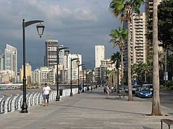 The Corniche, Beirut, Lebanon
 -
 Promenade on Rizal Boulevard in Dumaguete, Philippines
 -
 Sliema promenade, Malta
 -
 The Galle Face Green esplanade, Colombo, Sri Lanka
 -
 Gurney Drive, Penang, Malaysia
 -

-
 Blackpool's regenerated Promenade, England
 -
 Esplanade Row East, Kolkata, India
 -
![Iloilo River Esplanade, Iloilo City, Philippines - the longest linear park in the Philippines[4]](//upload.wikimedia.org/wikipedia/commons/thumb/6/6d/Iloilo_River_Esplanade.JPG/330px-Iloilo_River_Esplanade.JPG)
-
 Boston Esplanade, Boston, United States
 -
 Esplanade in the Olympic Park of Sochi, Russia
![Usedom, Western Pomerania, Germany - longest beach promenade in Europe[3] (Ahlbeck here)](https://en.wikipedia.org/wiki/File:StrandD%C3%BCne.JPG)


_view_to_W,Krakow,Poland.jpg)


![Iloilo River Esplanade, Iloilo City, Philippines - the longest linear park in the Philippines[4]](https://en.wikipedia.org/wiki/File:Iloilo_River_Esplanade.JPG)


See also
[edit]- Boardwalk
- Foreshoreway
- Malecón
- Oceanway
- Processional walkway
- Similar areas inland: Boulevard, mall
References
[edit]- ^ "Adopt-An-Esplanade". City of Houston. May 2013.
- ^ Tony Russell, Cycling England Archived 2011-01-31 at the Wayback Machine, January 2010
- ^ a b Europe's longest beach promenade from Bansin to Świnoujście (12 km)
- ^ "New sections of Iloilo Esplanade launched". www.pna.gov.ph. Retrieved 2021-09-04.