
Community hub
Recent from talks
Contribute something
Nothing was collected or created yet.
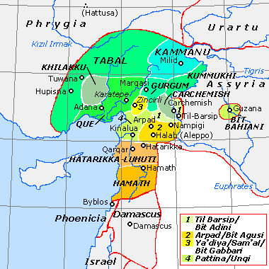
Carchemish
View on Wikipedia
Carchemish (/ˈkɑːrkəmɪʃ/ KAR-kəm-ish or /kɑːrˈkiːmɪʃ/ kar-KEE-mish), also spelled Karkemish (Turkish: Karkamış),[a] was an important ancient capital in the northern part of the region of Syria. At times during its history the city was independent, but it was also part of the Mitanni, Hittite and Neo-Assyrian Empires. Today it is on the frontier between Turkey and Syria.
Key Information
It was the location of an important battle, about 605 BC, between the Babylonians and Egyptians, mentioned in the Bible (Jer. 46:2, 2 Chron. 35:20).[7] Modern neighbouring cities are Karkamış in Turkey and Jarabulus in Syria (also Djerablus, Jerablus, Jarablos, Jarâblos).[8]
Geography of the site
[edit].jpg)
Carchemish is now an extensive set of ruins (90 hectares, of which 55 lie in Turkey and 35 in Syria), located on the West bank of Euphrates River, about 60 kilometres (37 mi) southeast of Gaziantep, Turkey, and 100 kilometres (62 mi) northeast of Aleppo, Syria. The site is crossed by the Baghdad Railway that now forms the Turco-Syrian border. The site includes an acropolis along the river, an Inner Town encircled by earthen ramparts and an Outer Town (most of which lies in Syrian territory). A Turkish military base has been established at the site and access but only the acropolis is presently of restricted access.
History of research
[edit]_and_T.E.Lawrence_at_the_British_Museum%27s_Excavations_at_Carchemish,_Syria,_in_the_spring_of_1912.jpg)
| ||||||
| qꜣrjqꜣmjꜥšꜣ[5][6] in hieroglyphs | ||||||
|---|---|---|---|---|---|---|
| Era: New Kingdom (1550–1069 BC) | ||||||
Carchemish has always been well known to scholars because of several references to it in the Bible (Jer. 46:2; 2 Chr. 35:20; Isa. 10:9) and in Egyptian and Assyrian texts. In 1874, James H. Skene, British Consul at Aleppo proposed its identification. This was confirmed in 1876 by George Smith.[9][10] Carchemish had been previously identified, incorrectly, with the Classical city of Circesium, at the confluence of the Khabur River and the Euphrates.[11]
Between 1878 and 1881 soundings were conducted by Consul Patrick Henderson on behalf of the British Museum.[9] Between 1911 and 1914 full excavations were conducted under the direction of D. G. Hogarth. In 1911 on the field there were D. G. Hogarth himself, R. C. Thompson, and T. E. Lawrence ("Lawrence of Arabia"), from 1912 to 1914 C. L. Woolley and T. E. Lawrence, while a last campaign took place in 1920 with C. L. Woolley and Philip Langstaffe Ord Guy.[12][13][14][15] Excavations were interrupted in 1914 by World War I and then ended in 1920 with the Turkish War of Independence.[16] These expeditions uncovered substantial remains of the Assyrian and Neo-Hittite periods, including defensive structures, temples, palaces, and numerous basalt statues and reliefs with Luwian hieroglyphic inscriptions.[17] Between 1956 and 1998, the whole site had been mined by the Turkish Land Forces.
With the completion in February 2011 of mine clearing operations on the Turkish portion of the site, archaeological work was resumed in September 2011.[18] Excavations in the Inner and Outer Towns were carried out by a joint Turco-Italian team from the Universities of Bologna, Gaziantep, and University of Istanbul under the direction of Prof. Dr. Nicolò Marchetti.[19] [20]
The second season, from August to November 2012, brought several new art findings and archaeological discoveries, the most remarkable of which is Katuwa's Palace (c. 900 BC) to the east of the Processional Entry.
The third season, from May to October 2013, extended the exposure of Katuwa's palace, retrieving a cuneiform tablet with an exorcism in the name of the god Marduk, as well as the ruins of Lawrence's excavation house in the Inner Town, from which literally hundreds of fragments of sculptures and hieroglyphic inscriptions have been retrieved.
The fourth season started in May 2014 and continued through October 2014: in Katuwa's palace several orthostats exquisitely carved with a procession of gazelle-bearers have been found, some of them in situ, next to a courtyard paved with squared slabs. In the Neo Assyrian period that courtyard was covered by a mosaic floor made of river pebbles forming squares alternating in black and white color. Lawrence's excavation house was completely excavated.
During the fifth season, April to October 2015, more significant discoveries have been made in the palace area, both for Late Hittite sculptures, and Neo Assyrian refurbishments, with tens of items—including two fragments of clay prismatical cylinders inscribed with a unique cuneiform text by Sargon, intended for display, telling how he captured and reorganized the city of Karkemish—retrieved in a 14-m-deep well, sealed in 605 BC at the time of the Late Babylonian takeover.[21]
The sixth season, May to July 2016, saw a number of excavation areas opened also near the border, due to the added security represented by the construction of the wall (see below). Thus, in 2016 a complete stratigraphic record was obtained also for peripheral areas, greatly adding to our understanding of urban development between LB II and the Achaemenid period.
In the seventh season, from 7 May to 18 July 2017, the major breakthroughs were the beginning of the excavations on the north-western end of the acropolis and the discovery in the eastern Lower Palace area of a monumental building dating from the LB II. Among the finds, in addition to new sculpted complete artworks from the Iron Age, fragments of Imperial Hittite clay cuneiform tablets and c. 250 inscribed bullae should be mentioned.
The eighth season lasted from 4 May to 20 July 2019 and revealed a massive palace on the top of the acropolis dating from Late Bronze II, exposed more architecture and finds from the LB II administrative building in area C East (which seems to be the Hittite E2.KIŠIB) and more of the Iron I storage facility in area S.
Archaeological investigations on the Syrian side have been conducted as part of the Land of Carchemish project:[22] investigations of the Outer Town of Carchemish were undertaken in conjunction with the DGAM in Damascus and with the funding and sponsorship of the Council for British Research in the Levant and of the British Academy, under the direction of the late Professors T. J. Wilkinson and E. Peltenburg.[23]
Current status
[edit]Conservation and presentation works have now been completed and the archaeological park at the site is finally open since 13 July 2019, thanks to the support also of Gaziantep Metropolitan Municipality and Gaziantep Province: the site may be visited between 9 am and one hour before sunset through guided tours every two hours for security reasons. Financial support has been received by the three Universities mentioned above, by the Italian Ministry of Foreign Affairs,[24] and the Sanko Holding,[25] with the technical support also of Şahinbey Municipality and Inta A.Ş.
The Outer Town area lying in Syria has been designated, already before the Syrian Civil War, an endangered cultural heritage site and labelled "at risk" by the Global Heritage Fund,[26] due to agricultural expansion and, especially, urban encroachment. The field assessment of the Syrian part of the Outer Town documented that parts of the modern border town of Jerablus encroached upon the Outer Town.[27] In July 2019, a scientific visit to the outer town in Syria by the Turco-Italian Archaeological Expedition at Karkemish, entailed the protection of the area from further encroachment by the sprawling town of Jerablus and by the facilities for trucks which were being built to the South of the border: the City Council of Jerablus declared all the area enclosed by the Iron Age city walls a "first degree protected site", meaning the complete ban of any activity on it.
In February 2016, a prefabricated security wall (thus with no foundations that could have damaged the ancient site) was completed by the Turkish Army to the south of the railway, stretching between the Euphrates bridge and the train station of Karkamış.
History
[edit]36°49′47″N 38°00′54″E / 36.82972°N 38.01500°E

The site has been occupied since the Neolithic and Chalcolithic periods[28] (pot burials).
Early Bronze
[edit]Early Bronze IIIB
[edit]In the late Early Bronze, cist tombs dating to around 2400 BC have been found.
Early Bronze IVA
[edit]The city is mentioned in documents found in the Ebla archives of the 3rd millennium BC.[7]
Middle Bronze
[edit]Middle Bronze IIA
[edit]According to documents from the archives of Mari and Alalakh, dated from c. 1770s-1760s BC and contemporary with king Zimri-Lim of Mari. Carchemish was ruled by a king named Aplahanda, followed by his son, Yatar-Ami, and was an important center of timber trade. It had treaty relationships with Ugarit and Mitanni (Hanilgalbat). Another ruler of Carchemish in that period was Iahdun-Lim.[29] In ancient times, the city commanded the main ford in the region across the Euphrates, a situation which must have contributed greatly to its historical and strategic importance. After about 1745 BC, and the reign of Yahdul-Lim, not much is further known about Carchemish.
Middle Bronze IIB
[edit]Hittite influence
[edit]Little is known until the 1620s, when the city is mentioned in connection with the siege of Urshu (Ursha) by the Hittite king Hattusili I.[30] At that time, Carchemish was allied with the kingdom of Yamhad, centered in Aleppo, in supporting Urshu, but their efforts were unsuccessful, and the city fell, along with many other Syrian cities. Hattusili and his successor Mursili I campaigned several years against Yamhad. Also Hantili I conducted a campaign to Carchemish to face the Hurrians.
Late Bronze
[edit]Egyptian influence
[edit]Pharaoh Thutmose I of the Eighteenth Dynasty erected a stele near Carchemish to celebrate his conquest of Syria and other lands beyond the Euphrates.
Mitanni influence
[edit]Under the Mitanni Empire, the city was a stronghold of Tushratta of Mitanni until its siege and conquest by Šuppiluliuma I (c. 1345 BC).
Hittite influence
[edit]Around the end of the reign of Pharaoh Tutankhamen, Carchemish was captured by king Šuppiluliuma I of the Hittites (c. 14th century BC), who made it into a kingdom ruled by his son Piyassili.
Piyassili (Šarri-Kušuḫ) was followed by his son Shakhurunuwa (fr:Sahurunuwa), about whom relatively little is known. He participated in the Battle of Kadesh (1274 BC). He was followed by Ini-Teššub.[31]
Iron Age
[edit]
The city became one of the most important centres in the Hittite Empire, during the Late Bronze Age, and reached its apogee around the 13th century BC. While the Hittite empire fell to the Sea Peoples during the Bronze Age collapse, Carchemish survived the Sea Peoples' attacks to continue to be the capital of an important Neo-Hittite kingdom in the Iron Age, and a trading center.[33]
Although Ramesses III states in an inscription dating to his 8th Year from his Medinet Habu mortuary temple that Carchemish was destroyed by the Sea Peoples, the city evidently survived the onslaught.[34]
Kuzi-Teshub I
[edit]King Kuzi-Teshub (Kuzi-Tesup) is attested in power here and was the son of Talmi-Teshub who was a contemporary of the last Hittite king, Šuppiluliuma II.[35] He and his successors ruled a "mini-empire" stretching from Southeast Asia Minor to Northern Syria and the West bend of the Euphrates[36] under the title "Great King". This suggests that Kuzi-Tesub saw himself as the true heir of the line of the great Šuppiluliuma I and that the central dynasty at Hattusa was now defunct.[37] This powerful polity lasted from c. 1175 to 975 BC when it began losing control of its farther possessions and became gradually a more local city state centered around Carchemish.[38][39]
After Kuzi-Teshub, some of the kings of Carchemish, such as Tuthaliya I, Sapaziti, and Ura-Tarhunza, continued to use the title ‘Great King’ in order to advance their power interests.[40]
House of Suhi
[edit]Suhi I was the first known ruler of the dynasty of Carchemish that followed. He ruled in early 10th century BC, and was followed by Astuwalamanza.
Katuwa, son of Suhi II, is the best known ruler of this dynasty as known in the Hieroglyphic Luwian sources. He reigned around 880 BC.
Relations with Assyria
[edit]In the mid-13th century BC, after the fall of the Mitanni, Shalmaneser I visited Carchemish together with Prince Tukultī-Ninurta.[41]
In the 9th century BC, King Sangara (870-848 BC), the last member of the dynasty, paid tribute to Kings Ashurnasirpal II and Shalmaneser III of Assyria.[42]
Sangara already appeared in the Balawat Bronze Bands of Ashurnasirpal II as a tributary probably at some time before 868 BC. According to the archaeologist Shigeo Yamada, Karkamish may have been known during this period as 'Sazabê', “a fortified city of Sangara the Karkamishean”. Nevertheless, Sangara failed to leave any inscriptions at the city of Karkamish itself as far as is known.[43] Still, in 2015 his name was identified in Hieroglyphic Luwian for the first time in a local inscription.
Following this period, Karkamish does not appear in Assyrian sources until the mid-8th century BC. The only exception was a brief mention by Samši-Adad V (824–811 BC). Nevertheless, only 20 km downstream the Euphrates river, at the city of Til-Barsip (modern Tell Ahmar), the Assyrians established an important provincial capital. They renamed their new city as 'Kar-Shalmaneser', yet the old name was also used.[43]
Stele of Kubaba
[edit]In 2015, for the first time, the name of Sangara has been documented in a hieroglyphic Luwian inscription originally erected in Carchemish, itself.[40] The six extant pieces of the basalt stele of the goddess Kubaba from Karkemish, currently housed in three different museums, have finally been all discovered and assembled together. This stele was made by king Kamani of Karkemish around 790 BC.[40] The top part of this stele was drawn in 1876 by George Smith and transported in 1881 to the British Museum.
In 1876, this was the longest hieroglyphic Luwian inscription known until then. Based on it, Smith was the first to link the site with the Hittites as mentioned in the Bible, and also to identify it as Carchemish.[40]
The House of Suhi are known for their extensive building program. They left a prominent set of monuments, with sculptures and inscriptions.[44] Among the monuments they left, there are portal lions, inscriptions, relief orthostats and freestanding statues.
House of Astiruwa
[edit]The House of Astiruwa was the last known dynasty of rulers of Carchemish, and king Astiruwa (ca 848-790 BC) was the founder of this dynasty. Then came kings Yariri, Kamani, and Sastura.
King Yariri started to reign after 790 BC.[45] He was a great scholar, and left extensive records of his time.[46]
Carchemish was conquered by Sargon II in 717 BC in the reign of King Pisiri, the last ruler of the House of Astiruwa.
Battle of Carchemish
[edit]In the summer of 605 BC, the Battle of Carchemish was fought there by the Babylonian army of Nebuchadnezzar II and that of Pharaoh Necho II of Egypt and the remnants of the Assyrian army (Jer. 46:2). The aim of Necho's campaign was to contain the Westward advance of the Babylonian Empire and cut off its trade route across the Euphrates. However, the Egyptians were defeated by the unexpected attack of the Babylonians and were eventually expelled from Syria.
After a brief Neo-Babylonian occupation, the Turco-Italian excavations found evidence for three phases of Achaemenid occupation, a significant reconstruction in Hellenistic times, a monumental phase from the Late Roman period, an Early Byzantine and three Abbasid phases before the final abandonment of the site until the early 1900s.[47]
Kings of Carchemish
[edit]
| Ruler | Proposed reign (BC) | Notes |
|---|---|---|
| Adni-anda (?) | c. ? to 1786 | |
| Aplah-anda I | c. 1786 to 1764 | son of Adni-anda |
| Yatar-Ami | c. 1764 to 1763 | son of Aplah-anda I |
| Yahdun-Lim, or possibly Yahdul-Lim | c. 1763 to 1745? | son of Bin-Ami |
| Aplah-anda II | c. 1745? to ? | son of Yahdun-Lim? |
| Piyassili or Sharri-Kushukh | c. 1315 | son of the Hittite king Šuppiluliuma I |
| [ ... ]sharruma | son of Piyassilis | |
| Shakhurunuwa | son of Piyassilis | |
| Ini-Teshub I | c. 1230s | |
| Talmi-Teshub | c. 1200 | |
| Kuzi-Teshub | c. 1170 | claimed the title of "Great King" after the fall of Hatti |
| Ini-Teshub II | c. 1100 | |
| Tudhaliya | c. 1100 | either before or after Ini-Teshub II |
| Sapaziti | c. 1025 | |
| Uratarhunda | c. 1000 | |
| Suhi I | c. 975 | |
| Astuwalamanza | c. 950 | |
| Suhi II | c. 925 | |
| Katuwa | c. 900 | |
| Suhi III | c. 890 | |
| Sangara | c. 870–848 | |
| Isarwilamuwa | c. 840 | |
| Kuwalanamuwa | c. 835 | |
| Astiru | c. 830 | |
| Yariri (regent) | c. 815 | |
| Kamani | c. 790 | |
| Sastura | c. 760 | |
| Astiru II | (?) | |
| Pisiri | c. 730s | the last king, defeated in 717 by Sargon II |
Goddess Kubaba
[edit].jpg)
The patron goddess of Carchemish was Kubaba, a deity of apparently Hurrian origins.[49] She was represented as a dignified woman wearing a long robe, standing or seated, and holding a mirror. The main male deity of the town was Karhuha, akin to the Hittite stag-god Kurunta.
Kubaba was also the goddess of Alalakh, located in the coastal Amik Valley.
In 2015, a basalt stele of Kubaba, originally from Karkemish, was assembled back together from six separate broken pieces currently housed in three different museums around the world. This stele was originally made by king Kamani of Karkemish around 790 BC. The Luwian hieroglyphic inscription on this stele can now be read more fully, and it carries some important information about Karkemish history.[40]
Kubaba appears to be one of the three main deities worshipped in Carchemish during the Middle Bronze Age. The other two were Nergal and Nubandag. The chief god was the Mesopotamian-influenced Nergal, who was the city-god of Carchemish. He was also called Il-Karkamis, “God of Karkemish”, as is evidenced on an Old Babylonian hematite cylinder seal in the British Museum collections (BM 89172).[50]
The warrior god Nubandag has Hurrian roots. According to the Mari texts, he was worshipped at Carchemish in the Old Babylonian period along with Nergal.[50]
Later, beginning in the mid-14th century BC, the city-god of Carchemish became the warrior god Karhuha, similar to Kurunta (god). He was seen as a Stag-god, and his cult was probably introduced to Carchemish under the Mitannian influence.[50]
These deities clearly reflect the geographical position of Carchemish at the crossing of important trade routes; because of this, the city became a mixed cultural and religious centre.
Material Culture
[edit]Among the many artefacts recovered at Karkemish, typical of this territory are the Handmade Syrian Horses and Riders and the Syrian Pillar Figurines. These are clay figurines dating from mid-8th-7th centuries BCE that have been found in several hundreds in the town. These terracottas were manufactured during the Neo-Assyrian phase of Karkemish and it is currently believed they might have represented male and female characters performing distinguished public roles.[51]
See also
[edit]Notes
[edit]References
[edit]- ^ "Kargamiš." Hawkins J.D., 1980.
- ^ Hawkins, John D (2000). Corpus of Hieroglyphic Luwian Inscriptions. Vol. 1: Inscriptions of the Iron Age. Part 1: Text, Introduction, Karatepe, Karkamis, Tell Ahmar, Maras, Malatya, Commagene. Walter de Gruyter. p. 74. ISBN 978-3-110-80420-1.
- ^ Hawkins, John D (2000). Corpus of Hieroglyphic Luwian Inscriptions. Vol. 1: Inscriptions of the Iron Age. Part 3: Plates. Walter de Gruyter. pp. 80, 83. ISBN 978-3-110-10864-4.
- ^ Parpola, Simo (1970). Neo-Assyrian Toponyms. Kevaeler: Butzon & Bercker. pp. 364–365.
- ^ a b Gauthier, Henri (1928). Dictionnaire des Noms Géographiques Contenus dans les Textes Hiéroglyphiques. Vol. 5. pp. 157–158.
- ^ a b Wallis Budge, E. A. (1920). An Egyptian hieroglyphic dictionary: with an index of English words, king list and geological list with indexes, list of hieroglyphic characters, coptic and semitic alphabets, etc. Vol II. John Murray. p. 1042.
- ^ a b Lemche, Niels Peter (2004). Historical dictionary of ancient Israel. Historical dictionaries of ancient civilizations and historical eras. Lanham, Md.: Scarecrow Press. p. 91. ISBN 978-0-8108-4848-1.
- ^ "Lawrence of Arabia . Locations . Syria". Pbs.org.
- ^ a b Alessandra Gilibert, "Carchemish". in Syro-Hittite Monumental Art and the Archaeology of Performance: The Stone Reliefs at Carchemish and Zincirli in the Earlier First Millennium BCE, Berlin, New York: De Gruyter, pp. 19-54,2011
- ^ Wm. Hayes Ward, "Unpublished or Imperfectly Published Hittite Monuments. III. Reliefs at Carchemish=Jerablûs", The American Journal of Archaeology and of the History of the Fine Arts, vol. 4, no. 2, pp. 172–74, 1888
- ^ Issac H Hall, "Proceedings at Boston, May 30th, 1877", Journal of the American Oriental Society, vol. 10, pp. cxxxiv–cxlv, 1872
- ^ H. Frowde (1911). David George Hogarth, Hittite problems and the excavation of Carchemish (PDF). Nabu Press. ISBN 978-1-171-63699-1.
{{cite book}}: ISBN / Date incompatibility (help) - ^ Hogarth D.G. 1914, repr. 1969.
- ^ Woolley C.L., 1921, repr. 1969.
- ^ "C.L. Woolley C.L. & Barnett R.D., 1952, repr. 1978" (PDF). Archive.org.
- ^ Güterbock H.G., 1954, pp. 102–114.
- ^ Wright, William (1886). The Empire of the Hittites: with Decipherment of Hittite inscriptions (PDF). Nisbet.
- ^ Ancient city to rise in SE Turkey area cleared of mines. Daily News & Economic Review 31.03.2011
- ^ Nicolò Marchetti (2012). "Karkemish on the Euphrates: Excavating a City's History". Near Eastern Archaeology. 75 (3): 132–147. doi:10.5615/neareastarch.75.3.0132. JSTOR 10.5615/neareastarch.75.3.0132. S2CID 163384370.
- ^ Marchetti, Nicolò (January 2020). "Marchetti, N. (Ed.) (2019-2020), "Recent archaeological discoveries at Karkemish. Anatomy and trajectories of a capital city on the Middle Euphrates"". in De Martino, S. – Marazzi, M. – Mora, C. (eds.), News from the Lands of the Hittites. Scientific Journal for Anatolian Research, vol. 3-4 (2019-2020), pp. 251-400.
- ^ Frame, Grant, "Carchemish", in The Royal Inscriptions of Sargon II, King of Assyria (721–705 BC), University Park, USA: Penn State University Press, pp. 421-426, 2021
- ^ "Land of Carchemish (Syria) Project". Durham University. Retrieved 15 September 2019.
- ^ Edgar Peltenburg, Euphrates River Valley Settlement: The Carchemish Sector in the Third Millennium BC, Oxbow Books, 2007, ISBN 1-84217-272-7
- ^ "Italian archaeological, anthropological and ethnological missions abroad". Esteri.it.
- ^ "xcavations in Zeugma and Carchemish Ancient City". Retrieved 8 April 2023.
- ^ "Satellite Imagery Briefing: Monitoring Endangered Cultural Heritage Sites - Global Heritage Fund | GHF" (PDF).
- ^ T.J. Wilkinson; E. Peltenberg (November 2010). ""Carchemish in Context: Surveys in the Hinterland of a Major Iron Age City."". Bulletin of the Council for British Research in the Levant. 5 (1): 11–20(10). doi:10.1179/175272710X12828116505919.
- ^ Langer, William L., ed. (1972). An Encyclopedia of World History (5th ed.). Boston, MA: Houghton Mifflin Company. pp. 9. ISBN 0-395-13592-3.
- ^ Douglas Frayne, "Carchemish", in Old Babylonian Period (2003-1595 B.C.): Early Periods, Volume 4, Toronto: University of Toronto Press, pp. 773-778, 2016
- ^ Seton Lloyd (21 August 2007). Hittite Warrior. Bloomsbury USA. p. 44. ISBN 9781846030819.
- ^ [1] Mora, Clelia, Maria ElenaBalza, and Marco De Pietri, "The Court and Administration of Karkemish in the Late Bronze Age", Administrative Practices and Political Control in Anatolian and Syro-Anatolian Polities in the 2nd and 1st Millennium BCE: pp. 93-126, 2023
- ^ "figure | British Museum". Britishmuseum.org. Retrieved 26 June 2022.
- ^ Federico Giusfredi, Sources for a Socio-Economic History of the Neo-Hittite States, Winter Verlag, 2010, pp. 35-51.
- ^ Gary Beckman, "Hittite Chronology", Akkadica, pp.119–120 (2000), p.23
- ^ K.A. Kitchen, On the Reliability of the Old Testament, William B. Eerdsman Publishing Co, pp.99 & 140
- ^ Kitchen, op. cit., p.99
- ^ Trevor R. Bryce, The Kingdom of the Hittites, Oxford University Press, p.384
- ^ Kitchen, op. cit., p.100
- ^ Giusfredi, op.cit., pp. 37-44
- ^ a b c d e Marchetti, Nicolò; Peker, Hasan (16 July 2018). "The Stele of Kubaba by Kamani and the Kings of Karkemish in the 9th Century BC". Zeitschrift für Assyriologie und vorderasiatische Archäologie. 108 (1). Walter de Gruyter GmbH: 81–99. doi:10.1515/za-2018-0006. ISSN 0084-5299. S2CID 165166999.
- ^ Shibata, Daisuke, "An Expedition of King Shalmaneser I and Prince Tukultī-Ninurta to Carchemish", in At the Dawn of History: Ancient Near Eastern Studies in Honour of J. N. Postgate, edited by Yağmur Heffron, Adam Stone and Martin Worthington, University Park, USA: Penn State University Press, pp. 491-506, 2017
- ^ Trevor Bryce: The World of the Neo-Hittite Kingdoms: A Political and Military History. Oxford, New York 2012, p. 302.
- ^ a b J.D. Hawkins, M. Weeden (2016), Sketch history of Karkamish in the earlier Iron Age (Iron I–IIB). in Tony J. Wilkinson, Edgar Peltenburg 2016 (eds), CARCHEMISH IN CONTEXT - THE LAND OF CARCHEMISH PROJECT, 2006–2010. Oxbow Books, ISBN 1785701118 p.13
- ^ Sanna Pauliina Aro-Valjus (1 January 2013). "Carchemish Before and After 1200 BC". Luwian Identities. BRILL. pp. 233–276. doi:10.1163/9789004253414_013. ISBN 9789004253414. at academia.edu
- ^ Gilibert, Alessandra (2011). Syro-Hittite Monumental Art and the Archaeology of Performance. De Gruyter. p. 135
- ^ Zsolt Simon (2012), Where is the Land of Sura of the Hieroglyphic Luwian inscription KARKAMIŠ A4b and Why Were Cappadocians Called Syrians by Greeks? Altoriental. Forsch., Akademie Verlag 39
- ^ Zaina F. (ed.) 2019.
- ^ H. Peker, Texts from Karkemish I. Luwian Hieroglyphic Inscriptions from the 2011-2015 Excavations (OrientLab Series Maior 1), Disci-Ante Quem, Bologna, 2016, pp. 47-49
- ^ Hutter M. 2003, pp. 211-280.
- ^ a b c Marchesi, Gianni; Marchetti, Nicolò (2019). "The Deities of Karkemish in the Middle Bronze Age according to Glyptic and Textual Evidence". Pearls of the past: studies on Near Eastern art and archaeology in honour of Frances Pinnock. Münster: Zaphon. ISBN 978-3-96327-058-1. OCLC 1099837791.
- ^ Bolognani B. 2017, pp.172, 220, 246-247; 2020a; 2020b.
BRITISH MUSEUM EXPEDITION
- [2] Hogarth D.G., Carchemish I: Introductory, The British Museum Press, London 1914, repr. 1969.
- [3] Woolley C.L., Carchemish II: Town Defences: Report on the Excavations at Jerablus on Behalf of the British Museum, British Museum Press, London 1921, repr. 1969, ISBN 0-7141-1002-7. Carchemish II
- [4] Woolley C.L. & Barnett R.D., Carchemish III: Excavations in the Inner Town: Report on the Excavations at Jerablus on Behalf of the British Museum, British Museum Press, London 1952, repr. 1978, ISBN 0-7141-1003-5. Carchemish III
TURCO-ITALIAN EXPEDITION
- Bitelli G., Girardi F., Girelli V.A., Digital enhancement of the 3D scan of Suhi I's stele from Karkemish, in Orientalia 83/2 (2014), pp. 154–161.
- Bolognani B.,The Iron Age Figurines from Karkemish (2011–2015 Campaigns) and the Coroplastic Art of the Syro-Anatolian Region, unpublished doctoral dissertation, University of Bologna, Bologna (2017). amsdottorato.unibo.it/8222/7/Bolognani_Barbara_tesi.pdf
- Bolognani B., "The Iron Age Female Figurines from Karkemish and the Middle Euphrates Valley. Preliminary Notes on Some Syrian Pillar Figurines", in Donnat S., Hunziker-Rodewald R., Weygand I. (eds), Figurines féminines nues : Proche-Orient, Égypte, Nubie, Méditerranée, Asie centrale (VIIIe millénaire av. J.-C. - IVe siècle ap. J.-C.), Proceedings of the International Conference “Figurines féminines nues. Proche-Orient, Egypte, Nubie, Méditerranée, Asie centrale”, June 25th-26th 2015, MISHA, Strasbourg, Études d’archéologie et d’histoire ancienne (EAHA), De Boccard, Paris, pp. 209–223 (2020a). Bolognani 2020a
- Bolognani, B., "Figurines as Social Markers: The Neo-Assyrian Impact on the Northern Levant as Seen from the Material Culture", in Gavagnin K., Palermo R. (eds), Imperial Connections. Interactions and Expansions from Assyria to the Roman Period. Proceedings of the 5th “Broadening Horizons” Conference, 5–8 June 2017, Udine(West & East Monografie 2), University of Udine, Udine, pp. 43–57 (2020b).Bolognani 2020b
- Dinçol A., Dinçol B., Hawkins J.D., Marchetti N., Peker H., A Stele by Suhi I from Karkemish, in Orientalia 83/2 (2014), pp. 143–153.
- Dinçol A., Dinçol B., Peker H., An Anatolian Hieroglyphic Cylinder Seal from the Hilani at Karkemish, in Orientalia 83/2 (2014), pp. 162–165.
- Marchesi G., Epigraphic Materials of Karkemish from the Middle Bronze Age, in Orientalia 83/2 (2014), pp. 166–181.
- Marchesi G., A Bilingual Literary Text from Karmenish Featuring Marduk (with contributions by W.R. Mayer and S.V. Panayotov), in Orientalia 83/4 (2014), pp. 333–340.
- Marchetti N., "The 2011 Joint Turco-Italian Excavations at Karkemish", in 34. kazı sonuçları toplantısı, 28 Mayıs-1 Haziran 2012, Çorum. 1. cilt, T.C. Kültür ve Turizm Bakanlığı, Ankara (2013), pp. 349–364. kulturvarliklari.gov.tr/Eklenti/7332,34kazi1.pdf?0
- Marchetti N., The 2012 Joint Turco-Italian Excavations at Karkemish, in 35. kazı sonuçları toplantısı, 27–31 Mayıs 2013, Muğla. 3. cilt, T.C. Kültür ve Turizm Bakanlığı, Ankara (2014), pp. 233–248. kulturvarliklari.gov.tr/Eklenti/27148,35kazi3.pdf?0
- Marchetti N., Karkemish. An Ancient Capital on the Euphrates (OrientLab 2), Ante Quem, Bologna (2014). free download orientlab.net/pubs (free download)
- Marchetti N., Bronze Statuettes from the Temples of Karkemish, in Orientalia 83/3 (2014), pp. 305–320.
- Marchetti N., Karkemish. New Discoveries in the Last Hittite Capital, in Current World Archaeology 70 (2015), pp 18–24. world-archaeology.com/issue-70/cwa-70.htm
- Marchetti N., Les programmes publics de communication visuelle à Karkemish entre la fin du IIe millénaire et le début du Ier millénaire avant J.-C., in V. Blanchard (ed.), Royaumes oubliés. De l'Empire hittite aux Araméens, Louvre éditions, Paris, (2019), pp. 154–161.
- Marchetti N. et al., Karkemish on the Euphrates: Excavating a City's History, in Near Eastern Archaeology 75/3 (2012), pp. 132–147.jstor.org/stable/10.5615/neareastarch.75.issue-3
- Marchetti N., Peker H., A Stele from Gürçay near Karkemish, in Orientalia 83/2 (2014), pp. 182–188.
- [5] Peker, Hasan, "A New Funerary Stele from Karkemish and New Values for Some Anatolian Hieroglyphic Signs", Belleten 87.309, pp. 357–383, 2023
- Peker H., A Funerary Stele from Yunus, in Orientalia 83/2 (2014), pp. 189–193.
- Peker H., Texts from Karkemish I. Luwian Hieroglyphic Inscriptions from the 2011-2015 Excavations (OrientLab Series Maior 1), Ante Quem, Bologna (2016).
- Pizzimenti S., Three Glyptic Documents from Karkemish, in Orientalia 83/2 (2014), pp. 194–201.
- Zaina F. (ed.), Excavations at Karkemish I. The Stratigraphic Sequence of Area G (OrientLab Series Maior 3), Ante Quem, Bologna, (2019).
- Zecchi M., A Note on Two Egyptian Seal Impressions from Karkemish, in Orientalia 83/2 (2014), pp. 202–206.
OTHER REFERENCES
- GüterbockH.G., Carchemish, in Journal of Near Eastern Studies 13/2 (1954), pp. 102–114.
- Hayes Ward W.M., Unpublished or Imperfectly Published Hittite Monuments. III. Reliefs at Carchemish=Jerablûs, The American Journal of Archaeology and of the History of the Fine Arts, vol. 4, pp. 172–174, (1988).*[6]
- Hawkins J.D.,"Kargamiš.", Reallexikon der Assyriologie und Vorderasiatischen Archäologie, Walter de Gruyter, Berlin (1980).
- Hawkins J.D., Corpus of Hieroglyphic Luwian Inscriptions I. Inscriptions of the Iron Age. Walter de Gruyter, Berlin (2000), ISBN 978-3-11-010864-4.
- Hutter M., "Aspects of Luwian Religion", in H.C. Melchert (ed.), The Luwians, Brill, (2003).
- Peltenburg E., Euphrates River Valley Settlement: The Carchemish Sector in the Third Millennium BC, Oxbow Books, (2007).
- Wilson D.M., The British Museum. A history. The British Museum Press, London, 2002.
- Woolley, C. Leonard, "The Prehistoric Pottery of Carchemish", Iraq, vol. 1, no. 2, pp. 146–62, 1934
External links
[edit]- Official website of the Turco-Italian Archaeological Expedition to Karkemish
- Land of Carchemish Project, Syria
- Activities of the joint Turkish-Italian Archaeological Mission (in Italian)
- Carchemish images
| Bronze Age | |
|---|---|
| Iron Age | |
| Classical Age | |
Syro-Hittite states and cities | |||||||||||||||||
|---|---|---|---|---|---|---|---|---|---|---|---|---|---|---|---|---|---|
| Luwian states |
|  | |||||||||||||||
| Aramaean states |
| ||||||||||||||||
| International | |
|---|---|
| National | |
| Geographic | |
| Other | |
Carchemish
View on GrokipediaGeography
Location and Environment
Carchemish is situated at approximately 36°50′ N 38°01′ E, straddling the international border between modern-day Turkey's Gaziantep Province and Syria's Aleppo Governorate.[5] The ancient city occupies a total area of about 90 hectares, with roughly 55 hectares on the Turkish side near the village of Karkamış and 35 hectares extending into Syrian territory adjacent to Jerablus.[6] This border division has influenced access to the site in contemporary times, limiting unified study and preservation efforts due to geopolitical tensions.[7] Positioned on the western bank of the Euphrates River, Carchemish served as a vital crossing point for ancient travelers and merchants, facilitating movement between the regions of Mesopotamia to the south and Anatolia to the north. The river's ford at this location made it a natural hub for overland caravans, enabling the exchange of goods such as metals, textiles, and agricultural products along the Euphrates corridor, one of the primary trade arteries of the ancient Near East.[8] The surrounding environment featured fertile alluvial plains along the Euphrates, which supported intensive agriculture through irrigation from seasonal floods and river terraces, contributing to the city's economic prosperity.[9] To the north, the site lay in proximity to the Taurus Mountains, whose foothills provided resources like timber and minerals while influencing local climate patterns with higher rainfall compared to the arid plains further south.[10] This combination of riverine fertility and mountainous backdrop underscored Carchemish's role as a strategic nexus in the northern Fertile Crescent.[8]Site Layout
Carchemish encompasses an expansive urban area of approximately 90 hectares, strategically divided into distinct zones that reflect its role as a fortified regional center. The site features a tripartite layout consisting of a high-walled acropolis rising along the Euphrates River, a walled lower Inner Town, and a roughly quadrangular Outer Town extending southward.[7] The Inner Town, covering about 30 hectares including the acropolis, served as the fortified core of the city and housed elite structures. The acropolis itself, elevated for natural defense, contained the royal palace and major temples, positioned to overlook the river and surrounding landscape. Adjacent to this, the Lower Town within the Inner Town included residential quarters and industrial zones, where everyday activities such as crafting and domestic life were concentrated. Notable features in this area include the Processional Way, a monumental avenue lined with sculpted orthostats leading from the gates toward the acropolis.[11][5] Defensive architecture was integral to the site's design, with massive city walls encircling the Inner Town and portions of the Outer Town, supplemented by riverfront fortifications along the Euphrates to deter fluvial assaults. Prominent gateways facilitated controlled access, including the King's Gate—a grand entrance to the Inner Town flanked by towers and orthostat reliefs—and the Lion Gate, marking a key passage in the Outer Town with lion-flanked portals symbolizing power. These walls, often double-layered with earthen ramparts, underscored Carchemish's military significance.[11] Urban planning in Carchemish exhibited organized elements, particularly in the Inner Town, where sections of grid-like streets divided residential and public spaces, facilitating movement and administration. Water management systems enhanced habitability, with large earthen canals and stone-lined channels drawing from the Euphrates to irrigate fields and supply the city, integrating the river's proximity for both defense and sustenance.[12]Archaeological Research
Early Excavations
The early archaeological investigations at Carchemish, conducted under the auspices of the British Museum, began in 1911 and continued intermittently until 1920, marking the site's first systematic exploration in modern times. The initial 1911 season was directed by D.G. Hogarth, who focused on the Lower Palace and acropolis areas, but yielded limited results, leading to his departure.[13] R. Campbell Thompson briefly served as field director that year, with T.E. Lawrence assisting in tasks such as pottery study and photography. From 1912 to 1914, C. Leonard Woolley took over as director, introducing more rigorous scientific approaches, and Lawrence continued as a key collaborator, contributing to architectural documentation and epigraphy.[14] The excavations were abruptly halted in 1914 by the outbreak of World War I, during which the site fell under Ottoman control and the team dispersed. Work resumed briefly in 1919–1920 under Woolley's leadership, with P.L.O. Guy assisting in topographic surveys, targeting the Lower Town and fortifications to complete earlier efforts.[13] The primary methods employed were large-scale trenching and systematic clearance, particularly within the Inner Town, including areas like the King's Gate, Herald's Wall, and Great Staircase; these techniques prioritized the recovery of monumental sculptures and inscriptions over stratigraphic precision, reflecting the era's exploratory focus.[15] Woolley emphasized horizontal exposure to map architectural layouts, using trenches up to several meters wide to uncover walls and gateways efficiently.[13] Among the preliminary discoveries were significant Hieroglyphic Luwian inscriptions, first identified in 1911 at the Great Staircase and later expanded upon, providing crucial insights into the Neo-Hittite period. Excavators also uncovered numerous basalt orthostats—carved stone slabs depicting processions, warriors, and deities—lining gateways and walls, as well as the Storm-god Temple within the Lower Palace complex, revealing ritual architecture from the Iron Age.[13] These finds, transported to the British Museum, highlighted Carchemish's role as a major cultural center.[14] The expeditions faced substantial challenges, including political instability in the Ottoman Empire and the ensuing war, which not only interrupted fieldwork but also complicated access and logistics. Post-war resumption in 1920 occurred amid French mandate administration in Syria, adding bureaucratic hurdles.[13] Publication of results was severely delayed; while preliminary reports appeared in the 1910s and 1920s, the comprehensive volumes, including detailed analyses of the Inner Town, were not completed until the 1950s due to wartime disruptions and shifting priorities.[15]Modern and Recent Excavations
Regional rescue excavations on the Syrian side, including at the nearby site of Jerablus-Tahtani, were conducted in the 1990s as part of a British-Syrian collaboration from 1992 to 1995 ahead of the Tishrin Dam's construction, revealing stratified settlements that contribute to understanding the broader Carchemish area.[16] Building on early 20th-century surveys by teams like Woolley's, modern work emphasized systematic regional surveys to map the site's extent across the border.[17] The joint Turco-Italian Archaeological Expedition at Karkemish, directed by Nicolò Marchetti of the University of Bologna since 2011 in partnership with Turkish authorities, has conducted annual seasons integrating multidisciplinary approaches.[18] This project utilizes geographic information systems (GIS) for spatial analysis, photogrammetry for 3D modeling of structures, and conservation techniques to stabilize exposed architecture, addressing gaps left by prior incomplete excavations.[19] Non-invasive methods, such as geophysical surveys and remote sensing, have been prioritized to minimize site disturbance amid the border location's logistical constraints.[20] Post-2020 developments include the 2022 discovery of the "House of the Seal" during the Turco-Italian campaigns, an administrative building yielding Hittite and Assyrian seals that enhance understanding of site chronology.[21] Ongoing excavations, including seasons in 2023 and 2024 by the Universities of Bologna, Istanbul, and Gaziantep, have revealed additional Hittite-period sculptures and extensions to palace complexes, employing drone-based photogrammetry for documentation, and yielded much new data enhancing our understanding of Karkemish's urban development. As of 2025, the project continues.[22][23] Turkey-Syria border tensions have complicated cross-border collaboration, limiting joint access to the full site despite shared heritage.[24] Conservation efforts gained momentum with site management plans to protect against erosion and potential flooding risks from nearby Euphrates dams.[25] These initiatives involve local stakeholders in monitoring and restoration, ensuring long-term preservation of the mound and lower town.Key Artifacts and Findings
One of the most prominent categories of artifacts from Carchemish consists of Neo-Hittite sculptures and reliefs, particularly the basalt orthostats that lined the walls of major structures such as the King's Gate and the Herald's Wall. These orthostats, dating primarily to the 10th–9th centuries BCE, feature carved scenes of royal processions, protective lions, and warriors in dynamic poses, exemplifying the blend of Hittite and local artistic traditions in monumental architecture.[26] A notable example is the basalt statue of King Katuwa from the 9th century BCE, depicting the ruler in a standing pose with accompanying Luwian hieroglyphic inscriptions that detail his building activities.[27] These sculptures were discovered during early 20th-century excavations in the Inner Town, highlighting the site's role as a center of Neo-Hittite artistry.[11] Inscriptions form another critical group of findings, with Luwian hieroglyphs carved on steles and orthostats providing insights into royal titles and achievements. A key example is the stele of Kuzi-Teshub from the late 12th century BCE, where the ruler claims the title of Great King (MAGNUS.REX) following the collapse of the Hittite Empire at Hattusa, marking a pivotal assertion of independence.[28] From the Middle Bronze Age, cuneiform tablets such as the Hogarth Tablet (BM 104895), dated to around 1800 BCE, record commercial transactions indicative of Carchemish's role in regional trade networks along the Euphrates.[29] These inscriptions were primarily recovered from palace and gate contexts during British Museum-led digs between 1911 and 1914.[30] Other significant artifacts include pottery sequences spanning the Bronze Age, with over 500 complete vessels from the Woolley-Lawrence collection illustrating typological evolution from Early Bronze Age painted wares to Late Bronze Age imports influenced by Syrian and Mesopotamian styles.[31] In the Neo-Assyrian period (late 8th century BCE), a pebble mosaic pavement composed of black and white river stones in a checkered pattern was uncovered in a courtyard of an Assyrian palace structure in Area C South, demonstrating imperial decorative techniques.[32] Ritual vessels, such as stone and glass bowls from temple-adjacent layers, were also found, often in deposits suggesting ceremonial use during the Iron Age.[19] Many of these artifacts are preserved in major institutions, with sculptures, reliefs, and the Katuwa statue housed in the British Museum in London, while orthostats and steles from the Herald's Wall are displayed in the Museum of Anatolian Civilizations in Ankara.[33][6] Replicas of key orthostats and inscriptions have been installed on-site at Carchemish to aid visitor interpretation and protect originals from environmental damage.[26]Bronze Age History
Early Bronze Age
The Early Bronze Age at Carchemish (c. 3000–2000 BC) marks the site's transition from modest habitation to an emerging urban center along the Euphrates River, reflecting broader patterns of settlement growth in northern Syria and southeastern Anatolia. During EB I–II (c. 3000–2700 BC), the site consisted of a small village with simple mud-brick structures and limited occupation layers on the acropolis mound, indicative of a community focused on subsistence rather than large-scale organization.[34] Excavations by Leonard Woolley in the early 20th century uncovered sparse remains from these phases, including basic pottery and tools, suggesting a population of farmers and herders exploiting the fertile river valley.[35] By EB III–IV (c. 2700–2000 BC), Carchemish underwent significant urbanization, with expanded settlement, defensive fortifications encircling the mound, and the introduction of monumental architecture. At least 15 cist tombs, constructed of stone slabs and dating to this period, were discovered on the acropolis, often containing pottery vessels and simple grave goods that highlight emerging social differentiation.[34] In subphase EB IIIB (c. 2500–2400 BC), evidence of early temple constructions appears, including rectangular platforms possibly dedicated to local deities, signaling ritual complexity amid urban expansion.[36] Further development in EB IVA (c. 2400–2000 BC) includes precursors to palatial structures, such as large multi-room buildings with thick walls, which may represent elite residences or administrative centers.[34] Carchemish's growing prominence is attested in contemporaneous records from distant sites, notably the Ebla archives (c. 2400 BC), where the city appears as Kár-Kamiš, involved in diplomatic and economic exchanges with the Syrian kingdom of Ebla.[37] These cuneiform tablets document Carchemish as a partner in regional networks, likely supplying goods like metals or agricultural products in return for Mesopotamian influences.[38] The economy during this period relied heavily on early agriculture, with evidence of emmer wheat, barley, and livestock rearing supported by the Euphrates floodplain, as inferred from plant remains and animal bones in settlement layers.[36] Obsidian trade from Anatolian sources, such as central Turkish deposits, is evident through tool fragments and blades found in EB contexts, underscoring Carchemish's role as a conduit between Anatolia and the Syrian interior. Material culture reveals external influences, including Kura-Araxes pottery traditions from the eastern highlands, characterized by black-burnished wares and incised designs on jars and bowls recovered from EB III–IV strata, pointing to cultural exchanges across the Upper Euphrates. Early seals, including stamp varieties with geometric motifs, appear in late EB IV deposits, suggesting nascent administrative practices for controlling goods and transactions.[34] These elements laid foundational continuity into subsequent phases, with building foundations persisting into the Middle Bronze Age.[36]Middle Bronze Age
The Middle Bronze Age at Carchemish (c. 2000–1600 BC) began with the MB IIA phase (c. 2000–1800 BC), characterized by Amorite migrations into northern Syria, which introduced new Semitic-speaking elites and reshaped local governance structures inherited from Early Bronze Age foundations.[39] These migrations integrated with existing populations, fostering a period of renewed urban vitality and commercial expansion along the Euphrates trade routes.[40] During MB IIB (c. 1800–1600 BC), Carchemish reached its peak as a semi-independent kingdom under the vassalage of Yamhad (centered at Aleppo), serving as a vital commercial hub linking Mesopotamia, Anatolia, and the Levant.[41] Key rulers documented in the Mari royal archives include Aplahanda (c. 1770s BC), who corresponded with Mari's Yasmah-Addu regarding timber shipments from the Upper Euphrates highlands to Aleppo, underscoring Carchemish's role in regional resource trade.[42] His son, Yatar-Ami (c. 1760s BC), maintained these ties, affirming allegiance to Mari's Zimri-Lim while navigating Yamhad's overlordship, as evidenced by diplomatic letters emphasizing familial bonds and mutual support.[29] These texts reveal Carchemish's strategic position in alliances with Mari and, to a lesser extent, Eshnunna, amid occasional tensions with Yamhad over territorial influence.[43] Urban growth accelerated in this period, with the expansion of the Lower Town beyond the Inner Town's Early Bronze walls, incorporating new residential and commercial quarters enclosed by massive ramparts.[41] Archaeological evidence points to rebuilds of the palace complex and temples, reflecting increased administrative and religious centralization under Amorite dynasties, supported by influxes from trade in timber, metals, and textiles.[5] This development solidified Carchemish's status as a prosperous crossroads, though its autonomy was constrained by Yamhad's periodic interventions.[40]Late Bronze Age
During the fifteenth century BC, Carchemish functioned as a strategic frontier fortress on the Euphrates, coming under Egyptian influence during the expansive campaigns of Thutmose III. In his eighth campaign around 1457 BC, Egyptian forces advanced to the vicinity of the city, ravaging the surrounding countryside to secure a crossing of the Euphrates but ultimately bypassing the capture of Carchemish itself, which remained a fortified outpost amid Mitanni-held territories.[44] This episode highlighted the city's role in the broader Egyptian-Mitanni rivalry, establishing it as a key point in the Levantine frontier without direct annexation. By the fourteenth century BC, Carchemish transitioned into a vassal under Mitanni dominance, integrating Hurrian cultural elements into its local traditions, particularly evident in artistic motifs and administrative practices. As part of the Mitanni kingdom's northern Syrian holdings, the city benefited from sustained river commerce inherited from Middle Bronze Age trade networks, facilitating exchanges along the Euphrates.[45] Hurrian influences appeared in seals and iconography, reflecting the ethnic composition of Mitanni elites and their oversight of regional vassals like Carchemish.[26] The Hittite conquest around 1340 BC, led by Šuppiluliuma I during his campaigns against Mitanni, decisively shifted Carchemish's political status, incorporating it as a core viceroyalty within the expanding Hittite Empire. Šuppiluliuma captured the city and appointed his son Piyassili (also known as Šarri-Kušuh) as viceroy circa 1320 BC, elevating Carchemish to the administrative capital for Hittite interests in Syria and transforming it into a semi-autonomous kingdom under direct imperial control.[46] This arrangement underscored the city's strategic importance, serving as a bulwark against eastern threats. Architectural developments under Hittite rule included the construction of fortified gates, such as the Water Gate in Area H and the South Gate in Area D, alongside temples and defensive walls that incorporated Anatolian stylistic elements like orthostats and monumental portals, blending local Syrian forms with Hittite engineering to reinforce imperial presence.[45] These structures, evidenced by ash layers indicating a transitional destruction around the Late Bronze I/II boundary, symbolized the syncretic cultural landscape of the period.[5]Iron Age History
Neo-Hittite Establishment
Following the collapse of the Hittite Empire around 1200 BC, Carchemish transitioned into an independent Neo-Hittite kingdom, serving as a rump-state that preserved elements of the former imperial administration. The impact of the Sea Peoples appears to have been minimal at the site, with no archaeological evidence of destruction layers attributable to these invaders during the late 13th or early 12th century BC. Instead, the local viceregal dynasty, established earlier under rulers like Piyassili during the Late Bronze Age, maintained continuity in governance. This dynasty claimed descent from the Hittite royal line, positioning Carchemish as the heir to Hattusa's legacy in northern Syria.[47] A pivotal figure in this establishment was Kuzi-Teshub, son of the last viceroy Talmi-Teshub, who ruled circa 1170 BC and asserted the title of "Great King" in hieroglyphic Luwian inscriptions, signaling the kingdom's elevation to sovereignty. Evidence for this comes from a bulla discovered at Lidar Höyük, which identifies him as king of Carchemish and bearer of prestigious Hittite titles such as "Hero" and "Country Lord." Politically, the new state was Luwian-speaking and autonomous, extending influence over territories from the Sajur Valley to Malatya, while adopting a decentralized structure that echoed Hittite provincial models without direct central oversight from Anatolia.[47] Early developments under the Neo-Hittite regime included the rebuilding of key infrastructure, such as temples and palaces, which supported renewed urban activity by the late 11th to early 10th century BC. These efforts facilitated economic recovery and territorial consolidation, with alliances formed with neighboring states like Tabal and Melid (Malatya) to counter regional fragmentation following Assyrian incursions in the late 12th century BC. Culturally, the kingdom emphasized continuity through the use of Luwian hieroglyphs as the primary administrative and monumental script, a practice inherited from Hittite traditions and employed in royal decrees from the 12th century BC onward. This script's persistence underscored Carchemish's role as a cultural bridge between the Bronze and Iron Ages.[48]Dynasties and Rulers
The Iron Age kingdom of Carchemish was governed by successive dynasties that emphasized continuity with Neo-Hittite traditions, beginning with the House of Suhi around 1100–1000 BC, often referred to collectively as the Suhi-Katuwa dynasty. This early ruling house focused on stabilizing the region after the collapse of the Hittite Empire, with rulers like Suhi I establishing authority through monumental inscriptions and building projects that included irrigation systems to support agriculture along the Euphrates. Suhi I, a country-lord and kinsman of the great king Ura-Tarhunta, set up a stele on the citadel commemorating Great King Ura-Tarhunta's resolution of a dispute with the land of Sura, which helped consolidate internal control and secure borders.[49][50][51] Successive generations, including Astuwalamanza and Suhi II, furthered these efforts by expanding monumental architecture, such as the Long Wall of Sculpture and additional steles, which reinforced dynastic legitimacy and promoted cultural identity. Suhi II, son of Astuwalamanza, led independent military campaigns, defeating adversaries like Hatamana, and integrated intermarriages with great kings like Tudhaliya to strengthen political alliances. These actions not only stabilized internal politics but also laid the groundwork for economic recovery through enhanced water management and land grants to loyal servants.[49][50][51] By the mid-10th century BC, the House of Astiruwa emerged as the dominant lineage within the Suhi-Katuwa dynasty, ruling from approximately 950–850 BC and building on the Suhi foundations. Katuwa, son of Suhi II and a key figure in this house around 900 BC, oversaw extensive palace construction and the erection of the Storm-God Temple and King's Gate, adorned with orthostats and portal lions that symbolized royal power. His reign featured strategic alliances, including aid from the grandsons of Ura-Tarhunzas in internal power struggles, and expansions westward that fostered trade networks with regions like Egypt and Cyprus, evidenced by imports of equids and luxury goods.[49][50][51] Other prominent figures, such as Ura-Tarhunzas, contributed to the dynasty's resilience by maintaining hierarchical titles and engaging in border skirmishes with the rival Aramean state of Bit-Adini to the south, protecting trade routes along the Euphrates. Overall achievements under these houses included a boom in monumental art programs, with hieroglyphic Luwian inscriptions standardizing royal ideology, and the expansion of commerce that positioned Carchemish as a cultural and economic hub in northern Syria. These internal developments, rooted in the Neo-Hittite legacy from rulers like Kuzi-Tešub, ensured the kingdom's prominence until the late 9th century BC.[49][50][51]Assyrian Relations and Fall
In the late 8th century BC, Carchemish entered into a tributary relationship with the Neo-Assyrian Empire under King Tiglath-Pileser III. Around 738 BC, the city's ruler Pisiri submitted as a vassal, paying tribute alongside other regional leaders such as Rezin of Damascus and Menahem of Samaria, as recorded in Assyrian tribute lists.[52] This arrangement marked the beginning of Assyrian dominance over Carchemish, integrating it into the empire's western provincial system while allowing limited local autonomy under Pisiri's rule.[53] Assyrian control intensified under Sargon II, who launched a campaign against Carchemish in 717 BC due to Pisiri's alleged betrayal and alliance with anti-Assyrian forces. The Assyrian forces besieged the city, leading to its conquest and the deposition of Pisiri; the king and much of the population were deported to Assyria, with the city's wealth seized and its army incorporated into the imperial forces.[54] Following the annexation, Carchemish was reorganized as an Assyrian provincial capital, with Sargon investing in its fortifications and infrastructure to secure the western frontier.[55] By the early 6th century BC, as Assyrian power waned, Carchemish became a flashpoint in the struggle between emerging empires. In 605 BC, the Battle of Carchemish pitted the Egyptian army under Pharaoh Necho II, supporting Assyrian remnants, against the Babylonian forces led by Crown Prince Nebuchadnezzar II. The Babylonians achieved a decisive victory, routing the Egyptians and eliminating their influence in Syria and the Levant, as detailed in the Babylonian Chronicle.[56] In the aftermath of the battle, Carchemish and the surrounding region came under Neo-Babylonian control, serving as a key administrative center until the Persian conquest of Babylon in 539 BC by Cyrus the Great. Under Achaemenid Persian rule, the city transitioned into a provincial outpost within the satrapy of Eber-Nari, but it gradually declined in prominence as trade routes shifted southward and major political centers moved elsewhere. By the Hellenistic period, Carchemish had largely faded as a significant urban site, its strategic importance overshadowed by newer developments.Rulers of Carchemish
List of Kings
The history of Carchemish's rulers is fragmentary, particularly for the Early and Middle Bronze Ages, where significant gaps exist due to limited textual evidence, and sequences such as that involving Adni-anda remain debated among scholars.[29] The primary sources for Bronze Age rulers are the Mari letters, which document diplomatic and trade relations.[57] In the Middle Bronze Age IIA (c. 1800–1750 BC), Aplahanda ruled Carchemish as a key ally in regional alliances, corresponding with kings like Yasmah-Addu of Mari.[57] His son, Yatar-Ami, succeeded him briefly in the Middle Bronze Age IIB (c. 1750–1700 BC), maintaining ties with Mari's Zimri-Lim, as evidenced by letters affirming familial bonds and ongoing ice trade from Ziranum.[57] No rulers are securely attested for the Early Bronze Age at Carchemish, leaving a chronological void before these figures. During the Late Bronze Age (c. 14th–13th centuries BC), under Hittite imperial control, Piyassili served as viceroy of Carchemish, appointed by his father Suppiluliuma I around 1344 BC; he adopted the throne name Sharri-Kushuh and governed from the city until his death c. 1315 BC, as recorded in Hittite royal annals.[58] Piyassili's successors continued the viceregal dynasty, overseeing Hittite interests in Syria until the empire's collapse. These included his son I-Sharruma (c. 1315–1300 BC), Ini-Teshub I (c. 1230s BC), Talmi-Teshub (c. 1200 BC), and Kuzi-Teshub (c. 1175 BC), who initially ruled as viceroys but later asserted independence.[59] The Iron Age rulers, emerging after the Hittite collapse c. 1180 BC, are better documented through Luwian hieroglyphic inscriptions and Assyrian annals, with the Suhi-Katuwa line establishing a prominent dynasty from the 10th to 9th centuries BC.| Ruler | Approximate Reign | Key Sources |
|---|---|---|
| Kuzi-Teshub I | c. 1170–1150 BC | Luwian seal impressions (e.g., from Lidar Höyük); claimed "Great King" title post-Hittite fall. |
| Ini-Teshub II | c. 1100 BC | Assyrian annals of Tiglath-pileser I, recording tribute extraction. |
| Ura-Tarhunza | c. 1000 BC | Luwian inscriptions associating with early Suhi rulers. |
| Suhi I | 10th century BC (c. 1000–950 BC) | Local Luwian inscriptions (e.g., KARKAMIŠ A1a+b), associating him with Ura-Tarhunza. |
| Katuwa | c. 900 BC (late 10th–early 9th century BC) | Luwian inscriptions on orthostats and stelae (e.g., KARKAMIŠ A11a+b, A12), detailing restorations and campaigns. |
| Suhi II | c. 925 BC | Luwian texts and Assyrian records. |
| Suhi III | c. 890 BC | Luwian inscriptions. |
| Sangara | c. 870–848 BC | Assyrian annals, tribute to Ashurnasirpal II. |
| Astiruwas | c. 840 BC | Luwian sources. |
| Yariris | c. 815 BC | Luwian inscriptions. |
| Kamanis | c. 790 BC | Luwian texts. |
| Sasturas | c. 760 BC | Assyrian records. |
| Pisiri | c. 730s BC (739/738–717 BC) | Assyrian annals of Tiglath-pileser III and Sargon II, noting tribute and deposition for conspiracy.[60] |