

Community hub
Recent from talks
Contribute something
Nothing was collected or created yet.
Paramaribo
View on WikipediaParamaribo[a] is the capital and largest city of Suriname, located on the banks of the Suriname River in the Paramaribo District. Paramaribo has a population of roughly 241,000 people (2012 census), almost half of Suriname's population.[1] The historic inner city of Paramaribo has been a UNESCO World Heritage Site since 2002.[3]
Key Information


Name
[edit]The city is named for the Paramaribo tribe living at the mouth of the Suriname River; the name is from Tupi–Guarani para "large river" + maribo "inhabitants".[4]
History
[edit]
The name Paramaribo is probably a corruption of the name of a native village, spelled Parmurbo in the earliest Dutch sources.[5] This was the location of the first Dutch settlement, a trading post established by Nicolaes Baliestel and Dirck Claeszoon van Sanen in 1613.[5] English and French traders also tried to establish settlements in Suriname, including a French post established in 1644 near present-day Paramaribo.
All earlier settlements were abandoned some time before the arrival of English settlers in 1650 to found Surinam. They were sent by the English governor of Barbados, Lord Francis Willoughby, 5th Baron Willoughby of Parham, and established a town on the site of Paramaribo (though probably south of the current town center). The town was protected by a fort, called Fort Willoughby. In 1662, Governor Willoughby was granted the settlement and surrounding lands (extending into Suriname's interior) by King Charles II. Around 1665 the village of Paramaribo was expanded and quickly outranked the earlier settlement of Torarica.[6]
In 1667, during the Second Anglo-Dutch War, Paramaribo was conquered by a squadron of ships under Abraham Crijnssen. The Treaty of Breda in 1667 confirmed Paramaribo as the leading town of the now Dutch colony of Suriname. The fort protecting Paramaribo was renamed Fort Zeelandia in honor of the Dutch province that had financed Crijnssen's fleet. (The town was also renamed New Middelburg but the name did not catch on with the inhabitants).

The population of Paramaribo has always been very diverse. Among the first British settlers were many Jews[7] and one of the oldest synagogues in the Americas, the Neveh Shalom Synagogue, is found in Paramaribo.[8] The population of the town was greatly increased after 1873, when former enslaved people (who had been freed in 1863) were allowed to stop working for their former masters and leave the sugar plantations.
Paramaribo has remained the capital of Suriname, from its colonial days through the independence of Suriname in 1975 to the present day. The old town has suffered many devastating fires over the years, notably in January 1821 (which destroyed over 400 buildings) and September 1832 (which destroyed nearly 50 buildings).[9] The slaves Kodjo, Mentor, and Present were found guilty of arson, and burnt alive.[10]
In May 1972, the Paramaribo Zoo opened.[11] In 1987, an administrative reorganization took place in Suriname and the city was divided into 12 administrative resorts (jurisdictions).
Geography
[edit]
The city is located on the Suriname River, approximately 15 kilometres (9.3 mi) inland from the Atlantic Ocean, in the Paramaribo district.
- Evolution of Paramaribo
-
 Paramaribo around 1737.
 -
 Paramaribo in 1821. Indicated in brown is the area devastated by the city fire of that year.
 -
 Paramaribo around 1876.
 -
 Paramaribo around 1916–1917

.jpg)

.jpg)
Climate
[edit]Paramaribo features a tropical rainforest climate (Af), under the Köppen climate classification. Because Paramaribo is more subject to the Intertropical Convergence Zone than the trade winds and sees no tropical cyclones, its climate is classified as equatorial. The city has no true dry season; all 12 months of the year average more than 60 millimetres or 2.4 inches of rainfall, but the city does experience noticeably wetter and drier periods during the year. The Northern Hemisphere "autumn" (September through November) is the driest period of the year in Paramaribo, and the heaviest rainfall occurs from April to July. Common to many cities with this climate, temperatures are relatively consistent throughout the course of the year, with average high temperatures of 30 degrees Celsius and average low temperatures of 24 degrees Celsius. Paramaribo on average receives roughly 2,135 millimetres or 84 inches of rainfall each year.
| Climate data for Paramaribo (Zorg en Hoop Airport) (1991–2020) | |||||||||||||
|---|---|---|---|---|---|---|---|---|---|---|---|---|---|
| Month | Jan | Feb | Mar | Apr | May | Jun | Jul | Aug | Sep | Oct | Nov | Dec | Year |
| Mean daily maximum °C (°F) | 29.2 (84.6) |
29.4 (84.9) |
28.7 (83.7) |
29.9 (85.8) |
30.0 (86.0) |
30.2 (86.4) |
30.7 (87.3) |
31.5 (88.7) |
32.0 (89.6) |
32.1 (89.8) |
31.2 (88.2) |
30.0 (86.0) |
30.4 (86.7) |
| Daily mean °C (°F) | 27.1 (80.8) |
27.3 (81.1) |
27.7 (81.9) |
27.9 (82.2) |
27.6 (81.7) |
27.4 (81.3) |
27.8 (82.0) |
28.7 (83.7) |
29.3 (84.7) |
29.3 (84.7) |
28.5 (83.3) |
27.5 (81.5) |
28.0 (82.4) |
| Mean daily minimum °C (°F) | 24.1 (75.4) |
23.2 (73.8) |
23.5 (74.3) |
24.5 (76.1) |
23.7 (74.7) |
24.4 (75.9) |
24.4 (75.9) |
24.6 (76.3) |
25.1 (77.2) |
25.1 (77.2) |
24.8 (76.6) |
24.2 (75.6) |
24.3 (75.7) |
| Average precipitation mm (inches) | 172.7 (6.80) |
146.2 (5.76) |
130.5 (5.14) |
215.8 (8.50) |
306.6 (12.07) |
295.6 (11.64) |
234.3 (9.22) |
147.7 (5.81) |
90.3 (3.56) |
86.5 (3.41) |
125.7 (4.95) |
183.7 (7.23) |
2,135.5 (84.07) |
| Average precipitation days (≥ 3.0 mm) | 15 | 12 | 14 | 16 | 22 | 22 | 20 | 15 | 11 | 12 | 13 | 18 | 190 |
| Average relative humidity (%) | 76.1 | 74.4 | 73.2 | 76.2 | 79.4 | 80.2 | 77.4 | 74.0 | 70.9 | 71.0 | 75.6 | 78.3 | 75.6 |
| Source 1: NOAA[12] | |||||||||||||
| Source 2: World Meteorological Organization[13] (Average precipitation days) | |||||||||||||
Demographics
[edit]| Year | Pop. | ±% p.a. |
|---|---|---|
| 1790 | 18,000 | — |
| 1831 | 15,265 | −0.40% |
| 1853 | 16,031 | +0.22% |
| 1980 | 167,798 | +1.87% |
| 1995 | 228,551 | +2.08% |
| 2004 | 242,946 | +0.68% |
| 2012 | 240,924 | −0.10% |
Paramaribo has a population of 240,924 people (2012 census). While the population number is stagnating in recent years, many towns in the surrounding Wanica District are increasing in population.[1]
The city is famed for its diverse ethnic makeup with 27% identifying as Creoles (African or mixed African-European descent), 23% as East Indian, 18% as Multiracial, 16% as Maroons (descendants of escaped enslaved Africans), 10% as Javanese, 2% as Indigenous, 1.5% as Chinese, and smaller numbers of Europeans (primarily of Dutch and Portuguese descent), Lebanese and Jews. In the past decades a significant number of Brazilians, Guyanese and new Chinese immigrants have settled in Paramaribo.
Economy
[edit]
.jpg)
Paramaribo is the business and financial centre of Suriname. Even though the capital city does not produce significant goods itself, almost all revenues from the country's main export products gold, oil, bauxite, rice, and tropical wood are channeled through its institutions. All banks, insurance corporations and other financial and commercial companies are headquartered in Paramaribo. Around 75 percent of Suriname's GDP is consumed in Paramaribo.[citation needed]
Tourism is an increasingly important sector, with most visitors coming from the Netherlands.[14]
Government
[edit]
Administratively, Paramaribo forms its own district in Suriname. The resorts of Paramaribo district therefore correspond to boroughs of the city. There are twelve resorts in the Paramaribo district:[1]
| Ressort/jurisdiction | Area in square km | Population density | Population (2012)[1] |
|---|---|---|---|
| Blauwgrond | 43 | 661.3 | 31,483 |
| Rainville | 31 | 930.7 | 22,747 |
| Munder | 14 | 1146.4 | 17,234 |
| Centrum | 9 | 3252.7 | 20,631 |
| Beekhuizen | 6 | 3297.2 | 17,185 |
| Weg naar Zee | 41 | 321.3 | 16,037 |
| Welgelegen | 7 | 3387.0 | 19,304 |
| Tammenga | 6 | 2385.5 | 15,819 |
| Flora | 4 | 3836.5 | 19,538 |
| Latour | 6 | 4358.0 | 29,526 |
| Pontbuiten | 6 | 3246.2 | 23,211 |
| Livorno | 9 | 931.8 | 8,209 |
Transport
[edit]
.jpg)

Paramaribo is served by the Johan Adolf Pengel International Airport and Zorg en Hoop Airport for local flights. The Jules Wijdenbosch Bridge, which is part of the East-West Link, connects Paramaribo with Meerzorg on the other side of the Suriname River.
The Jules Sedney Harbour is the main harbour for cargo.[15] The former harbour of Waterkant is used by ferries.[16]
Most airlines like Gum Air and Blue Wing Airlines have their head offices on the grounds of Zorg en Hoop Airport in Paramaribo.
Education
[edit]Paramaribo's institution of higher learning is Anton de Kom University of Suriname, the country's only university.
Teachers academy (Insituut voor de Opleiding van Leraren), the country's teachers academy to prepare teachers for secondary education levels.
AlphaMax Academy is a private international school established on September 1, 1998, in Paramaribo, Republic of Suriname. The school is run by the Directors of the AlphaMax Foundation.
Healthcare
[edit]
Paramaribo is home to four hospitals, the Academic Hospital Paramaribo, 's Lands Hospitaal, Sint Vincentius Hospital and Diakonessenhuis.
Historic inner city of Paramaribo
[edit]| UNESCO World Heritage Site | |
|---|---|
.jpg) Colonial style houses, Waterkant, Paramaribo | |
| Criteria | Cultural: ii, iv |
| Reference | 940 |
| Inscription | 2002 (26th Session) |
| Area | 30 ha |
| Buffer zone | 60 ha |
The Dutch colonial town established in 17th and 18th centuries was declared a UNESCO World Heritage Site in 2002.[17] The historic inner city is located along the left bank of the Suriname River. The original architecture of buildings and street plan has largely remained intact and preserved.
Notable landmarks
[edit].jpg)
.jpg)


- Fort Zeelandia
- Presidential Palace of Suriname
- Roman Catholic St Peter and St Paul Cathedral
- Suriname Mosque
- National Assembly of Suriname
- Neveh Shalom Synagogue
- The Arya Diwaker Hindu Temple
- Garden of Palms, a landscape garden of royal palms behind the presidential palace
- Centrumkerk
- Kwakoe, abolition of slavery memorial
Notable people
[edit]- Ashwin Adhin (born 1980), Vice President (2015–2020), politician[18]
- Ronny Aloema, football player
- Henck Arron, politician
- Maarten Atmodikoro, football player
- Regi Blinker, football player
- Remy Bonjasky, kickboxer
- Edson Braafheid, football player
- Stanley Brouwn, artist
- Romeo Castelen, football player
- Audrey Christiaan, activist
- Augusta Curiel, photographer[19]
- Edgar Davids, football player
- Johan Ferrier, politician
- Stanley Franker, tennis player
- Henk Fraser, football player
- Ulrich van Gobbel, football player
- Rebecca Gomperts, physician and women's rights activist
- Majoie Hajary, composer, pianist
- Jimmy Floyd Hasselbaink, football player
- Ruth Jacott, singer, Dutch representative in the Eurovision Song Contest 1993
- Jerry de Jong, football player
- Rajendre Khargi, journalist and ambassador to the Netherlands[20]
- Anton de Kom, resistance fighter and author
- Kelvin Leerdam, football player
- Coenraad van Lier, physician, politician[21]
- Jeangu Macrooy, singer, Dutch representative in the Eurovision Song Contest 2020 and the Eurovision Song Contest 2021
- Stanley Menzo, football player
- Felipe Enrique Neri, Baron de Bastrop (1729–1827), businessman and landowner known for his money in the Anglo-American settlement of Texas.
- Pim de la Parra, director
- Johan Adolf Pengel, politician
- Fred Ramdat Misier, politician
- Herman Rijkaard, football player
- Andy Ristie, kickboxer
- Jairzinho Rozenstruik, mixed martial artist and kickboxer
- Grace Schneiders-Howard, civil service worker/politician[22]
- Clarence Seedorf, football player
- Jennifer Simons, politician
- Andwélé Slory, football player
- Tyrone Spong, kickboxer and boxer
- Regilio Tuur, boxer
- Ronald Venetiaan, politician
- Mark de Vries, football player
- Jules Wijdenbosch, politician
- Fabian Wilnis, football player
- Aron Winter, football player
Twin towns – sister cities
[edit]Paramaribo is twinned with:
 Antwerp, Antwerp Province, Belgium
 Hangzhou, Zhejiang, China
 Willemstad, Curaçao, Netherlands[23]
 Yogyakarta, Special Region of Yogyakarta, Indonesia
 Miami-Dade County, Florida, United States[24]
See also
[edit]Notes
[edit]References
[edit]- ^ a b c d e "2012 Census Ressorts Suriname" (PDF). Spang Staging. Archived from the original on 4 May 2019. Retrieved 28 May 2020.
- ^ "Sub-national HDI – Subnational HDI – Global Data Lab".
- ^ "Historic Inner City Paramaribo". Unesco.org. Retrieved 29 May 2020.
- ^ E. M. Pospelov, Geograficheskie nazvaniya mira (Moscow: Russkie slovari, 1998), p. 322.
- ^ a b "Bijdragen en Mededeelingen van het Historisch Genootschap. Deel 35". Digital Library for Dutch Literature (in Dutch). 1914. Retrieved 29 May 2020.
- ^ "Paramaribo Suriname 2". Suriname.nu (in Dutch). Retrieved 29 May 2020.
- ^ "Extract of the Dutch Map Representing the Colony of Surinam". World Digital Library. 1777. Retrieved 2013-07-13.
- ^ Fox, Tamar (18 February 2011). "Discovering Suriname's Jewish past - and present". Travel. Washington Post. Retrieved 13 July 2013.
- ^ "Paramaribo Suriname". Suriname.nu (in Dutch). Retrieved 29 May 2020.
- ^ "Oog in oog met Paramaribo". De Lees Club van Alles (in Dutch). Retrieved 10 March 2021.
- ^ "Dieren in dierentuinen "Dieren worden niet meer gehouden voor slechts het plezier van de mens"". Dagblad Suriname (in Dutch). Retrieved 16 March 2021.
- ^ "World Meteorological Organization Climate Normals for 1991-2020 — Zorg en Hoop". National Oceanic and Atmospheric Administration. Retrieved March 30, 2024.
- ^ "World Weather Information Service:Paramaribo". Retrieved 29 December 2023.
- ^ "Archived copy" (PDF). Archived from the original (PDF) on 2015-09-24. Retrieved 2013-10-11.
{{cite web}}: CS1 maint: archived copy as title (link) - ^ "Dr. Jules Sedney Terminal". Havenbeheer (in Dutch). Retrieved 12 May 2021.
- ^ "DE GESCHIEDENIS VAN MEERZORG, ZOALS BESCHREVEN IN OUDE KRANTENBERICHTEN, DEEL 1 (1915-1940)". Plantage Justlust (in Dutch). Archived from the original on 12 May 2021. Retrieved 12 May 2021.
- ^ "UNESCO Listing of Paramaribo Inner City". Retrieved 31 Dec 2017.
- ^ "Adhin jongste vicepresident Suriname". Suriname Herald (in Dutch). Retrieved 13 July 2020.
- ^ djr (2016-10-11). "Digitaal Vrouwenlexicon van Nederland". resources.huygens.knaw.nl (in Dutch). Retrieved 2016-12-18.
- ^ "Rajendre Khargi nieuwe Surinaamse ambassadeur in Nederland". Werkgroep Caraibische Letteren (in Dutch). Retrieved 25 December 2021.
- ^ "Dr. Coenraad van Lier". Algemeen Handelsblad via Delpher.nl (in Dutch). 22 January 1903. Retrieved 24 December 2021.
- ^ Hoefte, Rosemarijn (6 March 2017). "Howard, Grace Ruth (1869-1968". Huygens ING (in Dutch). University of Groningen, Groningen, The Netherlands: Digitaal Vrouwenlexicon van Nederland. Archived from the original on 28 October 2017. Retrieved 28 October 2017.
- ^ Willemstad World Heritage City Archived 2010-02-09 at the Wayback Machine. Curacaomonuments.org. Retrieved on 2012-05-19.
- ^ "Miami-Dade County Sister Cities Program". miamidade.gov. Miami-Dade County. Retrieved 2021-01-20.
External links
[edit] Paramaribo travel guide from Wikivoyage
| International | |
|---|---|
| National | |
| Geographic | |
| Other | |
Paramaribo
View on GrokipediaParamaribo is the capital and largest city of Suriname, situated on the banks of the Suriname River near the Atlantic coast in northern South America.[1] The city serves as the country's primary economic, political, and cultural center, housing a diverse population shaped by centuries of European colonization, African slavery, and Asian indentured labor importation.[2] As of the 2012 census, Paramaribo's district population stood at 240,924, comprising about 40-50% of Suriname's total inhabitants depending on national estimates.[3] Originally developed as a Dutch colonial trading post and settlement starting in the early 17th century, with significant urban planning in the late 1600s, Paramaribo exemplifies a preserved grid layout of wooden architecture blending European techniques with tropical adaptations.[1] Its historic inner city was inscribed as a UNESCO World Heritage Site in 2002 under criteria (ii) and (iv) for demonstrating outstanding exchanges of human values through colonial cultural interactions and as an exemplary type of early modern urban ensemble in a tropical context.[1] The city's defining characteristics include its religious harmony—highlighted by the adjacent Keizerstraat Mosque and Neveh Shalom Synagogue—and a legacy of plantation-based economy that transitioned post-slavery abolition in 1863 to indentured systems, fostering a multiethnic society with Hindustani, African-descended, Javanese, and Amerindian communities.[1] Despite economic reliance on bauxite, oil, and agriculture, Paramaribo faces challenges like urban decay and infrastructure strain, yet retains notable landmarks such as Fort Zeelandia, originally built for defense against indigenous and rival colonial threats.[4]
Name and Etymology
Origins and Meaning
The name Paramaribo derives from indigenous languages prevalent in the region before European colonization, likely from the Arawak or related Amerindian tongues spoken by local tribes such as the Surinen or Arawaks. One scholarly interpretation traces it to Parmurbo, signifying "Flower City" in reference to the abundant vegetation and palm-lined waterways near the settlement's original site along the Suriname River and adjacent creeks like the van Sommelsdijkse Kreek. [5] An alternative derivation posits Panaribo as the root, potentially evoking local geographical features or tribal nomenclature, though etymological consensus remains tentative due to the oral nature of pre-colonial Amerindian linguistics and limited written records. Upon Dutch establishment of a permanent trading post in the early 17th century, the name evolved minimally from its indigenous form—initially rendered as Parmurbo or phonetic variants in colonial Dutch maps and documents—without significant alteration or imposed European renaming, preserving its Amerindian essence amid the transition to a fortified colonial outpost.[6] This linguistic continuity underscores Paramaribo's foundational ties to the multi-ethnic indigenous mosaic of Suriname, where Arawakan and Cariban language families predominated, reflecting a pre-colonial landscape shaped by riverine communities rather than later imported populations.[7] The retention of the name highlights how colonial administration often adapted rather than erased local toponymy, embedding Suriname's cultural identity in its capital's nomenclature from inception.History
Indigenous and Early European Settlement
The coastal region encompassing modern Paramaribo was inhabited by indigenous peoples for millennia prior to European arrival, with archaeological evidence pointing to human occupation dating back approximately 10,000 years. Pre-Columbian cultures in the area included the Kwatta, alongside Arawak (Lokono) and Carib (Kali'na) groups, who established villages along the Suriname River and engaged in agriculture, fishing, and trade networks across the Guianas.[8][9] These communities, numbering in the thousands regionally, utilized the riverine environment for sustenance and mobility, with no evidence of large-scale urbanization but rather dispersed settlements adapted to tropical floodplains.[10] European contact began with exploratory voyages in the late 16th century, as Dutch traders navigated the Suriname River for potential resources like timber and dyes, establishing incidental trade relations with local Arawak and Carib groups. Permanent settlement commenced in 1650 when English colonists under Francis Willoughby founded a plantation outpost near the river's mouth, constructing Fort Willoughby to secure the site against indigenous resistance and rival powers; this marked the initial European foothold in the area, displacing local villages through land clearance for tobacco and sugar cultivation.[11] Early interactions blended trade in foodstuffs and labor exchanges with mounting conflicts, as colonizers attempted to enlist indigenous workers, only to face raids and alliances among Carib groups that contributed to high settler mortality from ambushes and introduced diseases like smallpox, which decimated up to 90% of native populations in the Guianas by the century's end.[12][13] The Dutch seized the English settlement in 1667 amid the Second Anglo-Dutch War, renaming the fort Zeelandia and formalizing Paramaribo as a trading post under the Zeeland Chamber of the Dutch West India Company.[11] This transition intensified plantation expansion, with initial Dutch-indigenous diplomacy yielding temporary peace treaties for access to interior resources, though underlying tensions persisted due to slave raiding and territorial incursions that prompted Carib migrations inland. By the 1680s, the fort served as a defensive hub against both indigenous warfare and privateers, underscoring the precarious foothold amid a landscape still dominated by native autonomy beyond the immediate coastal perimeter.[14][15]Dutch Colonial Era
Following the Treaty of Breda in 1667, which transferred control of the settlement from English to Dutch authorities, Paramaribo emerged as the administrative capital and principal port of the Dutch colony of Suriname.[16] The city's strategic location on the Suriname River facilitated trade and governance, positioning it as the central hub for colonial operations amid the expansion of plantation agriculture.[17] Dutch planters, many displaced from Brazil in the mid-17th century, drove this development by establishing large-scale estates that relied on coerced labor to cultivate export commodities.[11] The plantation economy centered on sugar production initially, transitioning to coffee and other crops by the 18th century, with Paramaribo serving as the primary entry point for enslaved Africans imported to sustain this system.[18] Between the late 17th and early 19th centuries, Dutch shipping networks delivered tens of thousands of captives annually to Suriname, where they were distributed to plantations via the city's markets and wharves, fueling economic growth through forced agricultural output.[19] This labor-intensive model generated substantial revenues from sugar and coffee exports, with Paramaribo's role as a transshipment node integrating the colony into broader Atlantic commercial circuits.[20] Urban expansion under Dutch oversight incorporated grid-like street patterns influenced by metropolitan planning traditions, though adapted to local topography and climate with elevated wooden buildings to mitigate flooding and termite damage.[1] These structures, constructed primarily from tropical hardwoods, exemplified a pragmatic fusion of Dutch carpentry techniques and environmental necessities, forming the core of the colonial settlement's layout by the mid-18th century.[21] The system's viability persisted until the abolition of slavery on July 1, 1863, which dismantled the foundational economic reliance on enslaved labor without immediate disruption to Paramaribo's administrative prominence.[18]Transition to Independence
In the mid-20th century, Surinamese political leaders in Paramaribo, the colony's administrative and legislative center, began pressing for greater self-rule amid economic modernization and social changes. Discussions on internal autonomy commenced in 1948, coinciding with the Netherlands' initiation of development aid to Suriname, reflecting a gradual shift from direct colonial oversight.[11] By 1951, Suriname acquired expanding degrees of self-governance, culminating in full internal autonomy in 1954 under the Charter for the Kingdom of the Netherlands, which devolved control over domestic affairs to local authorities while retaining Dutch responsibility for defense and foreign policy.[17] [22] Paramaribo, seat of the Staten van Suriname legislative body, hosted these evolving political institutions and debates. Economically, the colony transitioned from reliance on declining plantation agriculture—post-emancipation in 1863—toward bauxite extraction, discovered in the early 1900s and commercially mined from 1916 by the Aluminium Company of America (Alcoa).[23] This sector boomed during World War II, positioning Suriname as the world's largest bauxite exporter by the 1940s and supplying up to 60% of U.S. imports, thereby generating revenues that supported infrastructure enhancements in Paramaribo, including port facilities and urban connectivity.[24] [25] The mining boom, centered in districts like Moengo but administered from the capital, fueled labor migrations to Paramaribo and modest urban expansion, though planning remained ad hoc until legislative frameworks like the 1972 Urban Development Act aimed to regulate growth.[26] Rising nationalist sentiments and unrest in the 1960s and early 1970s, including strikes over wages and representation, intensified calls for full sovereignty from Paramaribo's political class. Negotiations with the Dutch government proceeded despite resistance from Hindustani and Javanese communities wary of Creole political dominance post-independence. Suriname achieved sovereignty on November 25, 1975, marking a peaceful transfer with Paramaribo as the focal point of transitional governance.[11] [27]Post-Independence Instability and Military Rule
Following independence from the Netherlands on November 25, 1975, Suriname experienced rapid political instability, culminating in a military coup on February 25, 1980, led by Sergeant Major Desi Bouterse and a group of 16 non-commissioned officers who overthrew Prime Minister Henck Arron's government.[11] Bouterse established a military regime that ruled by decree, suspending the constitution and suppressing opposition through repressive measures.[28] As the capital, Paramaribo became the center of this authoritarian governance, with key military installations like Fort Zeelandia serving as sites of political detention and control. On December 8, 1982, the regime executed 15 prominent Surinamese opponents—including lawyers, journalists, academics, and business leaders—at Fort Zeelandia in Paramaribo, an event known as the December murders.[29] These killings, attributed to Bouterse's orders to eliminate perceived threats, sparked widespread domestic outrage and international condemnation, leading the Netherlands to suspend development aid.[11] In Paramaribo, the murders fueled protests and urban unrest, exacerbating tensions in the densely populated capital where diverse ethnic groups vied for influence amid economic strain. The regime's policies triggered the Surinamese Interior War from 1986 to 1992, as Maroon leader Ronnie Brunswijk formed the Jungle Commando guerrilla group to challenge military dominance, drawing on grievances over repression and economic marginalization.[30] Rebels repeatedly threatened Paramaribo's stability, including a 1989 seizure of the Afobaka Dam that risked flooding the city unless negotiations were pursued.[31] The conflict displaced approximately 13,000 interior residents to Paramaribo, straining the capital's resources and infrastructure with refugee influxes that overwhelmed urban services.[30] Under military rule, economic mismanagement included sharp increases in government spending—particularly on defense—coupled with nationalizations of key sectors and ties to socialist allies like Cuba and Libya, which alienated Western aid donors.[32] This led to stagnation, with GDP contracting nearly 4% in 1980 and persistent shortages causing long queues for basic goods in Paramaribo by the mid-1980s.[33] Hyperinflation emerged as a hallmark, driven by fiscal deficits and currency devaluation, further destabilizing the capital's markets and daily life during Bouterse's dictatorship from 1980 to 1987.[34]Contemporary Developments
Desi Bouterse held the presidency of Suriname from August 2010 to July 2020, securing election in 2010 and re-election in 2015 through his National Democratic Party coalition.[35] [36] His administrations were marked by deepened ethnic divisions and governance challenges in Paramaribo, where protests occasionally erupted over perceived favoritism toward Bouterse's Creole-Hindustani base, straining municipal resource allocation. In December 2023, Suriname's highest court upheld Bouterse's conviction for orchestrating the 1982 execution of 15 opponents, sentencing him to 20 years in prison—a ruling that highlighted lingering impunity issues but failed to resolve his influence in the capital's political networks.[37] [38] Bouterse evaded custody and died on December 25, 2024, from liver failure while in hiding in Paramaribo at age 79, prompting mixed public reactions including mourning rallies among supporters.[35] [39] In the May 2025 general elections, Suriname's consociational system—structured to foster ethnic consensus through coalition bargaining—facilitated the parliamentary selection of Jennifer Geerlings-Simons as the nation's first female president on July 6, 2025.[40] [41] Geerlings-Simons, a physician and long-serving National Assembly member from the NDP, ran unopposed after forging a broad coalition to displace the prior VHP-led government, emphasizing stability amid fiscal reforms.[42] [43] This shift aimed to recalibrate power-sharing in Paramaribo's diverse districts, though early implementation revealed persistent coalition fragilities. Decades of alternating populist regimes have eroded trust in Paramaribo's municipal administration, with corruption probes and subsidy mismanagement from the 2000s–2010s contributing to uneven urban planning and service delivery, such as delayed flood mitigation in low-lying neighborhoods.[40] [44] Public sentiment in the capital reflects this volatility: while Bouterse's death galvanized loyalists in Creole-heavy areas, broader frustration over institutional weakness—evident in 2023–2025 surveys showing low confidence in governance—has fueled demands for accountability, complicating Geerlings-Simons' efforts to unify the city's ethnic factions under consensus protocols.[45] [46]Geography
Physical Setting and Urban Layout
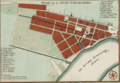
Paramaribo occupies the western bank of the Suriname River, situated approximately 15 kilometers inland from the Atlantic Ocean at coordinates 5°50′N 55°10′W.[16] The city's topography features a flat coastal plain, constructed on a shingle reef rising about 5 meters above sea level, with low-lying swamps and savannas nearby before giving way to inland tropical rainforests and rolling hills.[16][47] This positioning on the sediment-rich river delta facilitates historical trade access while exposing the area to seasonal flooding risks from the river's tidal influences.[48] As Suriname's primate city, Paramaribo serves as the overwhelmingly dominant urban center, concentrating economic, administrative, and cultural functions in a nation otherwise sparsely populated. The urban population stands at an estimated 238,000 as of 2025 projections, representing about 37% of Suriname's total population of roughly 642,000, though earlier censuses indicated closer to half due to rural-to-urban migration trends.[49][50] The spatial organization centers on the historic Centrum district along the riverfront, encompassing colonial-era wooden architecture and key landmarks within a grid-like layout established during Dutch rule.[1] The Paramaribo District, coextensive with the city proper, subdivides into 12 resorts, including expansions southward and northward into residential suburbs like Rainville and Pontbuiten, reflecting post-colonial growth patterns driven by population influx and informal settlements. This layout promotes a compact core with radiating low-density peripheries, though unregulated suburban development has led to fragmented urban edges abutting undeveloped forested areas.[51]Climate and Environmental Factors
Paramaribo experiences a tropical rainforest climate classified under the Köppen system as Af, marked by consistently high temperatures, elevated humidity, and substantial rainfall throughout the year. The average annual temperature stands at 26.1°C, with daily highs typically ranging from 31°C to 32°C and lows from 23°C to 24°C, exhibiting little seasonal fluctuation due to its equatorial location. Relative humidity remains persistently high, averaging 80-90%, contributing to an oppressive feel year-round.[52][53] Annual precipitation in Paramaribo totals approximately 1,793 mm, distributed relatively evenly across months, though wetter seasons occur from November to February and May to August, driven by the Intertropical Convergence Zone. This pattern results in frequent heavy showers and thunderstorms, with over 200 rainy days per year. Despite the rainfall, prolonged dry spells are rare, supporting lush vegetation but straining urban drainage systems.[53][52] The city's low elevation, averaging 2-10 meters above sea level along the Suriname River estuary, heightens its exposure to flooding from river overflow and storm surges. Historical data indicate a greater than 20% probability of damaging river floods within any 10-year period, exacerbated by upstream deforestation and inadequate infrastructure. Sea-level rise, projected at 0.5-1 meter by 2100 under moderate emissions scenarios, threatens to inundate up to 30% of Suriname's coastal land, including Paramaribo, where 66% of the national population resides, amplifying risks to infrastructure and settlements.[54][55][56] Surrounding Paramaribo, the coastal mangroves and inland rainforests harbor exceptional biodiversity, including over 1,600 tree species and diverse fauna in Suriname's largely intact ecosystems, which cover 93% of the country. In contrast, urban expansion has induced a heat island effect, elevating city temperatures by 1-3°C above rural surroundings, particularly during dry periods, as evidenced by sensor data from green and built areas. Urban green spaces, such as parks and waterways, provide measurable cooling—up to 2-4°C locally—mitigating this effect through evapotranspiration, though ongoing urbanization pressures challenge their preservation.[57][58]Demographics
Population Trends and Statistics
The population of Paramaribo District, which encompasses the urban core of the city, was 240,924 according to Suriname's 2012 Eighth General Population and Housing Census conducted by the Algemeen Bureau voor de Statistiek (ABS).[59] [3] This figure represented approximately 44% of Suriname's total population of 541,638 at the time.[60] Estimates for subsequent years indicate relative stability, with the urban agglomeration of Paramaribo at 239,000 in 2018 per U.S. Central Intelligence Agency assessments.[61] From the previous census period (2004 to 2012), Paramaribo's annual population growth rate was -0.10%, reflecting a slight decline amid broader national trends of low fertility and net out-migration.[3] Natural population increase, driven by birth rates exceeding death rates (national crude birth rate of 15.38 per 1,000 in recent estimates), has been partially offset by rural-to-urban migration inflows and subsequent emigration from the capital.[61] Rural-urban migration continues to concentrate population in Paramaribo, contributing to Suriname's overall urbanization rate of 0.88% annually (2020-2025 projection) and urban population share exceeding 66%.[62] The district covers 182 square kilometers, resulting in a 2012 population density of 1,324 inhabitants per square kilometer—over 300 times the national average of approximately 4 per square kilometer.[3] [50] This disparity underscores Paramaribo's role as the country's primary urban hub, where limited arable land nationally funnels settlement toward coastal and riverine areas. Projections for 2025, extrapolated from national growth rates of about 0.9-1.0% annually, suggest Paramaribo's population remains near 240,000, with minimal expansion due to persistent low district-level dynamics.[50][63]Ethnic and Cultural Composition
Paramaribo's ethnic composition reflects a blend of African, Asian, Indigenous, and European ancestries, shaped by colonial labor migrations following the abolition of slavery in 1863.[61] Indentured laborers from British India arrived between 1873 and 1916, establishing the Hindustani community, while Javanese workers from Dutch East Indies came from the 1890s to 1933, contributing to the Javanese population.[64] Smaller Chinese inflows occurred earlier in the 19th century, and Maroons—descendants of escaped enslaved Africans—maintain communities near the urban core.[65] In the 2012 census, Creoles, of mixed African and European descent, formed the largest group at 25.5% of Paramaribo's population, followed by Hindustanis at 22.9%, mixed heritage at 16.5%, Maroons at 13.7%, and Javanese at 13.1%, with remaining groups including Amerindians, Chinese, and Europeans comprising about 8.3%. This urban distribution contrasts with national figures, where Hindustanis predominate due to rural concentrations, highlighting Paramaribo's role as a cosmopolitan hub.[61] Culturally, ethnic groups preserve distinct practices amid intermingling in daily life. Hindustanis uphold Hindu and Muslim traditions with temples and mosques, Javanese maintain Islamic observances and gamelan music, while Creoles and Maroons blend Christian influences with African-derived customs like winti spirituality. [Sranan Tongo](/page/Sranan Tongo) serves as a lingua franca, facilitating commerce in markets and neighborhoods where vendors of varied origins interact routinely. Synagogues, churches, and temples coexist symbolically, as seen in the adjacent Keizerstraat Mosque and Neveh Shalom Synagogue.[64] Inter-ethnic marriages, though increasing, remain limited, with endogamy prevalent among larger groups per 2012 survey data.| Ethnic Group | Percentage (2012 Census, Paramaribo) |
|---|---|
| Creole | 25.5% |
| Hindustani | 22.9% |
| Mixed | 16.5% |
| Maroon | 13.7% |
| Javanese | 13.1% |
| Other (incl. Amerindian, Chinese, European) | ~8.3% |