Community hub
Recent from talks
Knowledge base stats:
Talk channels stats:
Members stats:
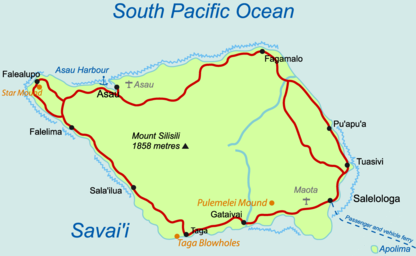
Savaiʻi
Savaiʻi is the largest and highest island both in Samoa and in the Samoan Islands chain. The island is also the sixth largest in Polynesia, behind the three main islands of New Zealand and the Hawaiian Islands of Hawaii and Maui. While it is larger than the second main island, Upolu, it is significantly less populated.
Samoans sometimes refer to the island of Savaiʻi as Salafai: This is its classical Samoan name, and is used in formal oratory and prose. The island is home to 43,958 people (2016 census), and they make up 24% of the population of Samoa. The island's only township and ferry terminal is called Salelologa. It is the main point of entry to the island, and is situated at the east end of Savaiʻi. A tar sealed road serves as the single main highway, connecting most of the villages. Local bus routes also operate, reaching most settlements.
Savaiʻi is made up of six itūmālō (political districts). Each district is made up of villages that have strong traditional ties with each other — of kinship, history, and land — and that use similar matai (titles for their village chiefs). Savaiʻi's relatively limited ecotourism operations are organized mostly at the village level. The Mau, Samoa's non-violent movement for political independence during colonialism in the early 1900s, had its beginnings on Savaiʻi, with the Mau a Pule movement.
The island is the largest shield volcano in the South Pacific. Its most recent eruptions were in the early 1900s. Its central region comprises the Central Savaiʻi Rainforest, extending over 72,699 hectares (726.99 square kilometres; 280.69 square miles) which is the largest contiguous rainforest in Polynesia. It is dotted with more than 100 volcanic craters and contains most of Samoa's native species of flora and fauna, making it one of the world's most globally significant conservation areas.
Faʻa Sāmoa, the unique traditional culture and way of life in Samoan society, remains strong in Savaiʻi, where there are fewer signs of modern life and less development than on the island of Upolu, where the capital, Apia, is located.
Samoan society is communal and based on extended family relationships and socio-cultural obligations, so that kinship and genealogies are important. These faʻa Sāmoa values are also associated with concepts of love (alofa), service (tautua) to family and community, respect (faʻaaloalo) and discipline (usitaʻi). Most families are made up of a number of different households situated close to each other.
Like the rest of Samoa, Savaiʻi is made up of villages with most of the land collectively owned by families or ʻaiga. Most people on Savaiʻi, 93% of the island population, live on customary land. The heads of the family are called matai, the holders of family names and titles. An extended family can have a number of chiefs with different chief titles. Men and women in Samoa have equal rights to chief titles which are bestowed by consensus of the extended family. Traditionally, male and female roles are defined by labours and tasks, chiefly status and age. Women play an important role contributing to family decisions as well as village governance. Elders are revered and respected. Social relationships are dictated by cultural etiquettes of politeness and common greetings.
The Samoan language has a 'polite' and formal variant used in Samoan oratory and ceremony as well as in communication with elders, guests, people of rank and strangers. In all villages, the majority of people are largely sustained by plantation work and fishing with financial assistance from relatives working in Apia or overseas. Most people live in coastal villages although there are some settlements inland such as the villages of Aopo, Patamea and Sili.
Hub AI
Savaiʻi AI simulator
(@Savaiʻi_simulator)
Savaiʻi
Savaiʻi is the largest and highest island both in Samoa and in the Samoan Islands chain. The island is also the sixth largest in Polynesia, behind the three main islands of New Zealand and the Hawaiian Islands of Hawaii and Maui. While it is larger than the second main island, Upolu, it is significantly less populated.
Samoans sometimes refer to the island of Savaiʻi as Salafai: This is its classical Samoan name, and is used in formal oratory and prose. The island is home to 43,958 people (2016 census), and they make up 24% of the population of Samoa. The island's only township and ferry terminal is called Salelologa. It is the main point of entry to the island, and is situated at the east end of Savaiʻi. A tar sealed road serves as the single main highway, connecting most of the villages. Local bus routes also operate, reaching most settlements.
Savaiʻi is made up of six itūmālō (political districts). Each district is made up of villages that have strong traditional ties with each other — of kinship, history, and land — and that use similar matai (titles for their village chiefs). Savaiʻi's relatively limited ecotourism operations are organized mostly at the village level. The Mau, Samoa's non-violent movement for political independence during colonialism in the early 1900s, had its beginnings on Savaiʻi, with the Mau a Pule movement.
The island is the largest shield volcano in the South Pacific. Its most recent eruptions were in the early 1900s. Its central region comprises the Central Savaiʻi Rainforest, extending over 72,699 hectares (726.99 square kilometres; 280.69 square miles) which is the largest contiguous rainforest in Polynesia. It is dotted with more than 100 volcanic craters and contains most of Samoa's native species of flora and fauna, making it one of the world's most globally significant conservation areas.
Faʻa Sāmoa, the unique traditional culture and way of life in Samoan society, remains strong in Savaiʻi, where there are fewer signs of modern life and less development than on the island of Upolu, where the capital, Apia, is located.
Samoan society is communal and based on extended family relationships and socio-cultural obligations, so that kinship and genealogies are important. These faʻa Sāmoa values are also associated with concepts of love (alofa), service (tautua) to family and community, respect (faʻaaloalo) and discipline (usitaʻi). Most families are made up of a number of different households situated close to each other.
Like the rest of Samoa, Savaiʻi is made up of villages with most of the land collectively owned by families or ʻaiga. Most people on Savaiʻi, 93% of the island population, live on customary land. The heads of the family are called matai, the holders of family names and titles. An extended family can have a number of chiefs with different chief titles. Men and women in Samoa have equal rights to chief titles which are bestowed by consensus of the extended family. Traditionally, male and female roles are defined by labours and tasks, chiefly status and age. Women play an important role contributing to family decisions as well as village governance. Elders are revered and respected. Social relationships are dictated by cultural etiquettes of politeness and common greetings.
The Samoan language has a 'polite' and formal variant used in Samoan oratory and ceremony as well as in communication with elders, guests, people of rank and strangers. In all villages, the majority of people are largely sustained by plantation work and fishing with financial assistance from relatives working in Apia or overseas. Most people live in coastal villages although there are some settlements inland such as the villages of Aopo, Patamea and Sili.