

Community hub
Recent from talks
Contribute something
Nothing was collected or created yet.
Machilipatnam
View on Wikipedia
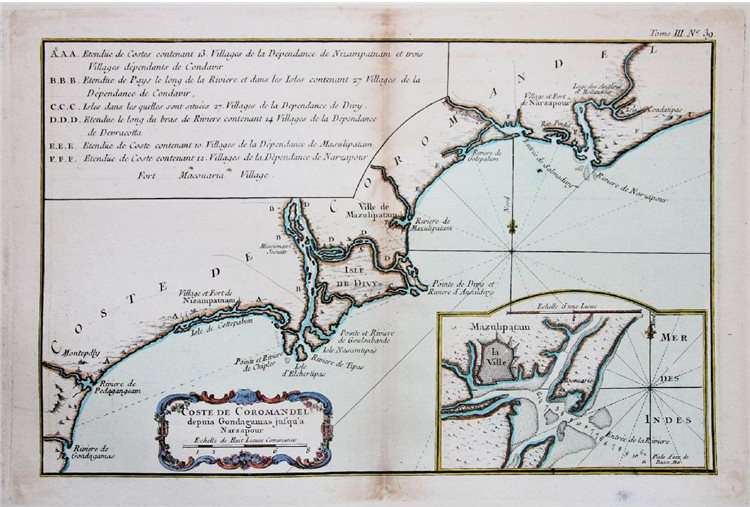
Machilipatnam (Telugu: [mɐt͡ʃiliːpɐʈnɐm] ⓘ), also known as Masulipatnam and Bandar (Telugu: [bɐn̪d̪ɐɾ]),[3] is a city in Krishna district of the Indian state of Andhra Pradesh. It is a municipal corporation and the administrative headquarters of Krishna district.[4] It is also the mandal headquarters of Machilipatnam mandal in Machilipatnam revenue division of the district.[5][6] The ancient port town served as the settlement of European traders from the 16th century, and it was a major trading port for the Portuguese, British, Dutch and French in the 17th century.[7]
Key Information

.svg)

Etymology
[edit]During the 17th century, it was known by the names Masulipatnam, Masulipatam,[8] Masula and Bandar (Bandar translates to 'port' in Persian language).[9][10][11] The port town in the ancient times was also referred with the name Maesolia.[8][12]
History
[edit]
The town has existed since at least the 3rd century BCE (Satavahana period) when, according to Ptolemy, it was known as Maisolos. The Periplus of the Erythraean Sea calls it Masalia in the 1st-century BCE.[13] The port is on the southeastern, or Coromandel Coast, of India. At the mouth of the River Krishna on the Bay of Bengal, the Masula port saw flourishing sea trade.[citation needed]
Muslin was traded by ancient Greeks from the town and the word muslin originated from the name Maisolos.[14] Muslin was an important source of income for the town, being a favourite of Roman traders for domestic consumption. Several Roman coins were found during excavations of Buddhist towns near Machilipatnam.[15]
The town served as the primary sea port for the Kingdom of Golkonda. It was an outlet for textiles produced in the Godavari Delta. It was a major source of income for the kingdom, and contributed to its immense prosperity in the 1620s and 1630s.[16]
By the end of the 17th century, the port city had fallen into decline. This coincided with the Mughal conquest of Golkonda. However, mismanagement prior to the conquest may have also been a factor in the city's decline.[17]
Salabat Jung, the son of Nizam-ul-Mulk Asaf Jah I, who was indebted for his elevation to the throne to the French East India Company, granted them in return for their services the district of Kondavid or Guntur, and soon afterwards the remainder of the Circars. The Circars were captured by the British from the French in 1759 and were returned to the Nizam. However Masulipatnam captured by the British during the Siege of Masulipatam was retained by the East India Company.[18]
The town was the district headquarters of the then, Masulipatnam district and now to the Krishna district, which was formed in 1859 in the composite Madras state.[6][19]
Geographical area
[edit]Machilipatnam city is at 16°10′N 81°08′E / 16.17°N 81.13°E on the southeast coast of India and in the east coast of Andhra Pradesh.[20] The city has an average elevation of 14 meters (45 feet).[21]
Climate
[edit]Machilipatnam (city) gets most of its annual rainfall due to the southwest monsoon. It has a tropical savanna climate (Köppen climate classification Aw) with hot summers and moderate winters. The hottest months are between April and June. The average normal rainfall in the district is 959 millimetres (37.8 in) and Machilipatnam is vulnerable to high surges of the sea due to cyclones. The 1864 Machilipatnam Cyclone claimed to have killed at least 30,000 people. The 1977 Andhra Pradesh cyclone crossed the coast near Nizampatnam and took approximately 10,000 lives. As the storm approached the coast, gale winds reaching 200 km/h lashed Prakasam, Guntur, Krishna, East Godavari and West Godavari districts. A storm surge, 5 meters high, inundated the Krishna estuary and the coast south of the city (Bandar).
On 8 December 2004, a high capacity S-Band Doppler cyclone warning radar was installed, commissioned and made operational at the city[22] by the German manufacturer Gematronik. With the installation of the radar, it is hoped the state will be better equipped to track cyclones. The facility will monitor the 960 km long coastline of the state.[23]
| Climate data for Machilipatnam (1991–2020, extremes 1901–2020) | |||||||||||||
|---|---|---|---|---|---|---|---|---|---|---|---|---|---|
| Month | Jan | Feb | Mar | Apr | May | Jun | Jul | Aug | Sep | Oct | Nov | Dec | Year |
| Record high °C (°F) | 34.5 (94.1) |
37.4 (99.3) |
42.2 (108.0) |
44.4 (111.9) |
47.8 (118.0) |
47.0 (116.6) |
42.8 (109.0) |
39.8 (103.6) |
38.2 (100.8) |
37.8 (100.0) |
35.4 (95.7) |
34.6 (94.3) |
47.8 (118.0) |
| Mean daily maximum °C (°F) | 29.5 (85.1) |
31.3 (88.3) |
33.5 (92.3) |
35.4 (95.7) |
37.8 (100.0) |
36.8 (98.2) |
34.2 (93.6) |
33.3 (91.9) |
33.3 (91.9) |
32.2 (90.0) |
30.8 (87.4) |
29.6 (85.3) |
33.1 (91.6) |
| Daily mean °C (°F) | 24.9 (76.8) |
26.3 (79.3) |
28.5 (83.3) |
30.8 (87.4) |
32.9 (91.2) |
32.1 (89.8) |
30.3 (86.5) |
29.8 (85.6) |
29.7 (85.5) |
28.5 (83.3) |
26.8 (80.2) |
25.0 (77.0) |
28.8 (83.8) |
| Mean daily minimum °C (°F) | 20.2 (68.4) |
21.4 (70.5) |
23.6 (74.5) |
26.2 (79.2) |
28.2 (82.8) |
27.7 (81.9) |
26.4 (79.5) |
26.1 (79.0) |
26.1 (79.0) |
25.0 (77.0) |
22.8 (73.0) |
20.5 (68.9) |
24.5 (76.1) |
| Record low °C (°F) | 13.4 (56.1) |
14.4 (57.9) |
16.1 (61.0) |
18.0 (64.4) |
17.8 (64.0) |
20.0 (68.0) |
19.0 (66.2) |
19.0 (66.2) |
18.3 (64.9) |
18.0 (64.4) |
13.9 (57.0) |
13.2 (55.8) |
13.2 (55.8) |
| Average rainfall mm (inches) | 6.9 (0.27) |
12.4 (0.49) |
0.9 (0.04) |
9.3 (0.37) |
43.3 (1.70) |
124.4 (4.90) |
182.9 (7.20) |
173.4 (6.83) |
183.7 (7.23) |
208.1 (8.19) |
114.4 (4.50) |
15.3 (0.60) |
1,074.9 (42.32) |
| Average rainy days | 0.6 | 0.6 | 0.2 | 0.6 | 1.9 | 6.5 | 10.5 | 10.4 | 8.7 | 8.6 | 3.7 | 0.9 | 53.1 |
| Average relative humidity (%) (at 17:30 IST) | 68 | 66 | 67 | 68 | 64 | 61 | 67 | 70 | 73 | 76 | 74 | 70 | 69 |
| Source 1: India Meteorological Department[24][25] | |||||||||||||
| Source 2: Tokyo Climate Center (mean temperatures 1991–2020)[26] | |||||||||||||

| Year | Pop. | ±% |
|---|---|---|
| 1871 | 36,188 | — |
| 1881 | 35,056 | −3.1% |
| 1891 | 38,809 | +10.7% |
| 1901 | 39,507 | +1.8% |
| 1911 | 42,123 | +6.6% |
| 1921 | 43,940 | +4.3% |
| 1931 | 56,928 | +29.6% |
| 1941 | 59,146 | +3.9% |
| 1951 | 77,953 | +31.8% |
| 1961 | 101,417 | +30.1% |
| 1971 | 112,612 | +11.0% |
| 1981 | 138,525 | +23.0% |
| 1991 | 159,110 | +14.9% |
| 2001 | 179,353 | +12.7% |
| 2011 | 169,892 | −5.3% |
Demographics
[edit]As of 2011[update] census, Machilipatnam had a population of 2,32,000. The total population constitutes 1,13,286 males and 1,18,714 females — a sex ratio of 1047 females per 1000 males. 13,778 children are in the age group of 0–6 years, of which 7,076 are boys and 6,702 are girls. The average literacy rate stands at 83.32% with 130,173 literates, significantly higher than the state average of 67.41%.[2][27]
Governance
[edit]Civic administration
[edit]Machilipatnam Municipal Corporation is the civic body of the city. It was constituted as a municipality in 1866 and was upgraded to corporation from special grade municipality on 9 December 2015.[28][29] It covers an area of 26.67 km2 (10.30 sq mi) under its jurisdiction. The present commissioner of the corporation is Sampath and the municipal chairperson is Motamarri Venkata Baba Prasad.[30]
Machilipatnam Urban Development Authority is the urban planning authority, headquartered at Machilipatnam.[31]
Politics
[edit]Machilipatnam is a part of Machilipatnam (Assembly constituency) for Andhra Pradesh Legislative Assembly. Kollu Ravindra is the present MLA of the constituency from the Telugu Desam Party.[32][33] The assembly segment is also a part of Machilipatnam (Lok Sabha constituency), which was won by Balashowry Vallabhaneni of Janasena Party.[34]
Economy
[edit]
Machilipatnam is known for its handloom industry, which produces Kalamkari textiles exported to United States and other Asian countries.[citation needed]
Other notable local industries are boat building and fishing.[35] Machilipatnam was a trading base for the Europeans in the 17th century and known for minting copper coins, exporting diamonds, textiles etc., through the port.[36]
The AP state government is taking measures to bring back the glory of the former port city. On 7 February 2019, it has started construction of a deep seaport and associated industrial corridor under the Machilipatnam Area Development Authority.[35][37]
Culture
[edit]Art and handicrafts
[edit]Machilipatnam Kalamkari is a handcrafted dyed block-painting of a fabric.[38] It is performed at the nearby town of Pedana and was registered with geographical indication from Andhra Pradesh.[39] Machilipatnam and Srikalahasti styles are the only existing Kalamkari style works present in India.[40]
Dance
[edit]Kuchipudi, a popular Indian Classical Dance form, originated at Kuchipudi, 25 kilometers from Machilipatnam.[41]
Cuisine
[edit]The city is well known for a sweet known as Bandar Laddu and Bandar Halwa.[42] Almond Milkshake is also largely famous in Machilipatanam which are Mostly centred in Koneru Centre. Bandar Biryani is delicious, which is made by Shia Muslims in Moharram rituals .
Religious worship
[edit]
There are many religions with worship centers in and around the city, such as Panduranga Temple at Chilakalapudi, Agastheeswara Temple etc. Dattashram is a pilgrimage site on the coast and home to ancient Shiva and Datta temples. Manginapudi is popularly known as "Datta Rameswaram" due to the consecration of 12 wells for bathing (recalling those at Rameswaram).[43]
Shia Muslims
[edit]Machilipatnam is home to the largest Shia Population in Entire Andhra Pradesh state .There are more than 100 Astanas/Imambargahs (Moharram ritual places).The Famous Chest beatings happens on Ashura in the Koneru Centre circle, attracting thousands of mourners and Visitors from other religions too .There are Imambargahs that are more than 600 years old like Zari Astana, Baraimam Astana, Naqla Astana..etc .The Baraimam Alam is taken out for procession around streets of Machilipatnam, It is taken out a night before Ashura and the krishna district police offers dhati (A cloth) to the Alam .Hundreds of Shia Muslisms from Hyderabad, Chennai, Bangalore, Visakhapatnam visit Chehlum Astana for the 17th Safar of Islamic Calendar, where Hazrat Abbas(as)'Arabaeen is done attracting many mourners across south India .
Tourism
[edit]Manginapudi Beach is on the coast of the city.[44] Machilipatnam also has the ruined buildings built by the Europeans who settled here.[45][46]
Transport
[edit]The city has a total road length of 359.09 km (223.13 mi).[47] The National Highway 65 connects Machilipatnam to Pune via Hyderabad, Suryapet and Vijayawada. NH 216 from Kattipudi to Ongole, passes through the city.
The city's bus station is owned and operated by Andhra Pradesh State Road Transport Corporation.[48][49] The station is equipped with a bus depot for storage and maintenance of buses.[50]
Machilipatnam railway station is a 'B–Category' and 'Adarsh station' under the jurisdiction of Vijayawada railway division.[51] It is the terminal station of Vijayawada-Machilipatnam branch line that connects Howrah-Chennai main line at Vijayawada.[52]
Machilipatnam port was damaged by a giant ocean wave on 1 November 1864.[36] Since then, there were many efforts to build a new port. Navayuga Engineering Company Limited is in the process of building a deep water port at Gilakaladinne of the city.[53]
The nearest International airport is Gannavaram, Vijayawada (63 kms).
Education
[edit]The primary and secondary school education is imparted by government, aided, and private schools of the School Education Department of the state.[54][55] Krishna University is located in Machilipatnam.
Notable natives
[edit]- N. Madhava Rao 23rd Dewan of Mysore
- Divi Gopalacharlu - Ayurvedic scholar[56]
- Timmarusu - Prime Minister of Raja Krishnadevaraya, the emperor of Vijayanagara Empire
- Pingali Venkayya - Independence activist; designer of the national flag
- Chitrapu Narayana Murthy - Indian director known for films like AVM's Bhaktha Prahlada (1967)
- Mutnuri Krishna Rao - Independence activist and journalist
- U. G. Krishnamurthy - Philosopher
- Bhogaraju Pattabhisitaramayya - Indian independence activist and political leader
- Raghupathi Venkaiah Naidu - father of Telugu cinema, Indian artiste and film maker
- C. K. Nayudu - Indian cricketer
- Poornima - Indian actress who starred in many Telugu, Tamil, Kannada and Malayalam films.
- Jagapathi Babu - Telugu actor.
- B. Vasantha - South Indian playback singer.
- Master Venu - Music composer of the Telugu and Tamil cinemas.
- C. S. R. Anjaneyulu - C. S. R., was an Indian film method actor, and thespian best known for his works in Telugu cinema and Telugu theater.
- Nirmalamma - Telugu actress known for her grandmother roles in old films.
- Maruthi - Indian director, screenwriter, producer who works primarily in Telugu cinema.
- Mani Sharma - Indian composer, singer, arranger, multi-instrumentalist and music producer known for his works primarily in the Telugu and Tamil cinema along with Hindi and Kannada films.
- Achyuth - Indian actor
- Srikanth Bolla - First Indian blind boy to study at Massachusetts Institute of Technology and an entrepreneur and founder of Bollant Industries.
- Turaga Desiraju - neurophysiologist and a professor at National Institute of Mental Health and Neurosciences
See also
[edit]References
[edit]- ^ "Machilipatnam at Glance". Machilipatnam Municipality. Archived from the original on 9 January 2016. Retrieved 12 May 2015.
- ^ a b "Statistical Abstract of Andhra Pradesh, 2015" (PDF). Directorate of Economics & Statistics. Government of Andhra Pradesh. p. 43. Archived from the original (PDF) on 14 July 2019. Retrieved 26 April 2019.
- ^ Rao 2002, p. 12.
- ^ "Mandals in East godavari district". aponline.gov.in. Archived from the original on 13 December 2014. Retrieved 4 February 2016.
- ^ "Krishna District Mandals" (PDF). Census of India. p. 517. Retrieved 18 January 2015.
- ^ a b "District Census Handbook – Krishna" (PDF). Census of India. pp. 15–16. Retrieved 8 January 2016.
- ^ Reddy 2008, p. 72.
- ^ a b Mackenzie, Gordon (1883). A manual of the Kistna district, in the presidency of Madras. Lawrence Asylm Press, Madras.
- ^ Guru Srikanth, S (2 April 2015). "Machilipatnam Growth May Trigger Off Reverse Migration". The New Indian Express. Machilipatnam. Archived from the original on 28 November 2015. Retrieved 10 December 2015.
- ^ George et al., p. 55.
- ^ Broeze 2010.
- ^ "The rise and fall of Maesolia port". The Hindu. 8 August 2015. Retrieved 1 September 2016.
- ^ The Great Stupa at Nagarjunakonda in Southern India, p. 187
- ^ Periplus, Point 62; http://legacy.fordham.edu/halsall/ancient/periplus.asp Archived 4 February 2017 at the Wayback Machine
- ^ Buddhist Monks and Monasteries of India: Their History and Their Contribution to Indian Culture by Sukumar Butt, Motilal Banarsidass Publishers, 1988, p. 132
- ^ Eaton 2008, p. 157.
- ^ Eaton 2008, p. 159.
- ^ One or more of the preceding sentences incorporates text from a publication now in the public domain: Chisholm, Hugh, ed. (1911). "Circar". Encyclopædia Britannica. Vol. 6 (11th ed.). Cambridge University Press. p. 380.
- ^ Poole 1865, p. 89.
- ^ "redirect to /world/IN/02/Machilipatnam.html". fallingrain.com.
- ^ "overview1758". Columbia University.
- ^ "Weather Radar Network of India Meteorological Department". India Meteorological Department. Archived from the original on 12 May 2015. Retrieved 13 November 2015.
- ^ "Andhra Pradesh News: Modern cyclone warning system for Machilipatnam". The Hindu. 8 May 2004.[dead link]
- ^ "Station: Masulipatnam (Machilipatnam) Climatological Table 1981–2010" (PDF). Climatological Normals 1981–2010. India Meteorological Department. January 2015. pp. 479–480. Archived from the original (PDF) on 5 February 2020. Retrieved 18 February 2020.
- ^ "Extremes of Temperature & Rainfall for Indian Stations (Up to 2012)" (PDF). India Meteorological Department. December 2016. p. M13. Archived from the original (PDF) on 5 February 2020. Retrieved 18 February 2020.
- ^ "Normals Data: Machilipatnam/Franchpet – India Latitude: 16.20°N Longitude: 81.15°E Height: 3 (m)". Japan Meteorological Agency. Retrieved 1 December 2022.
- ^ "Literacy of AP (Census 2011)" (PDF). Official Portal of Andhra Pradesh Government. p. 43. Archived from the original (PDF) on 14 July 2014. Retrieved 5 September 2014.
- ^ "Masula, Srikakulam, Vizianagaram upgraded into corporations". The Hindu. Vijayawada. 10 December 2015. Archived from the original on 10 December 2015. Retrieved 17 December 2016.
- ^ "Population Glitch for Masula to Turn into Corporation". Machilipatnam. 20 February 2015. Archived from the original on 25 November 2015. Retrieved 10 December 2015.
- ^ "Machilipatnam info". Machilipatnam Municipality. Archived from the original on 9 January 2016. Retrieved 11 December 2015.
- ^ "State constitutes Machilipatnam Area Development Authority". Machilipatnam. 2 February 2016. Retrieved 6 February 2016.
- ^ "MLA". Government of AP. Archived from the original on 8 October 2014. Retrieved 13 October 2014.
- ^ "Machilipatnam Assembly 2014 Election Results". Elections.in. Retrieved 13 October 2014.
- ^ "MP (Lok Sabha)". Government of AP. Archived from the original on 21 November 2016. Retrieved 4 May 2015.
- ^ a b Naga Sridhar, G. "A port all at sea". Retrieved 6 February 2016.
- ^ a b T. Appala Naidu (8 August 2015). "The rise and fall of Maesolia port". Machilipatnam. Retrieved 16 August 2015.
- ^ Appala Naidu, T (6 February 2016). "MADA to expedite work on deep-sea port project". The Hindu. Machilipatnam. Retrieved 6 February 2016.
- ^ "Kalamkari back in demand". The Hindu. Tirupati. 25 October 2010. Archived from the original on 10 August 2011.
- ^ "State Wise Registration Details of G.I Applications" (PDF). Geographical Indication Registry. p. 3. Archived from the original (PDF) on 1 February 2016. Retrieved 28 January 2016.
- ^ "Kalamkari: Craft of the matter". mid-day. 24 August 2015. Retrieved 26 January 2016.
- ^ Goyal, Anuradha (2 March 2017). "Kuchipudi Village – Dance Village Of Andhra Pradesh". Inditales. Retrieved 23 October 2020.
- ^ Varma, Sujatha (13 April 2013). "In search of Bandar Laddu". The Hindu. Retrieved 12 July 2015. Vani sweets, near to the Koneru center and RK sweets, near to the bus stand are famous in the city
- ^ "History". dattapeetham.com.
- ^ "Manginapudi Beach". Andhra Pradesh Tourism. Retrieved 30 January 2016.
- ^ "Monuments face utter neglect in Bandar Fort". Deccan Herald. Retrieved 19 May 2025.
- ^ "Machilipatnam in Andhra Pradesh: The tenuous link between the present and the past - The Hindu". The Hindu. 5 July 2023. Archived from the original on 5 July 2023. Retrieved 19 May 2025.
- ^ "Details of Roads in Each ULB of Andhra Pradesh". Commissioner and Directorate of Municipal Administration. Municipal Administration and Urban Development Department - Government of Andhra Pradesh. Archived from the original on 1 August 2016. Retrieved 28 March 2017.
- ^ "Bus Stations in Districts". Andhra Pradesh State Road Transport Corporation. Archived from the original on 22 March 2016. Retrieved 15 March 2016.
- ^ Mareedu, Mouli (21 May 2010). "RTC takes a low blow from Laila". The Times of India. Hyderabad. Archived from the original on 15 March 2016. Retrieved 15 March 2016.
- ^ "Depot Name". APSRTC. Archived from the original on 9 March 2016. Retrieved 15 March 2016.
- ^ "Vijayawada Division – a profile" (PDF). Indian Railways. Retrieved 13 February 2013.
- ^ "Machilipatnam Railway Station". India Rail Info. Retrieved 16 August 2015.
- ^ "G.O. on development of Machilipatnam deep water port" (PDF). Department of Ports. Government of Andhra Pradesh. Archived from the original (PDF) on 17 June 2015. Retrieved 17 June 2015.
- ^ "School Education Department" (PDF). School Education Department, Government of Andhra Pradesh. Archived from the original (PDF) on 19 March 2016. Retrieved 7 November 2016.
- ^ "The Department of School Education - Official AP State Government Portal | AP State Portal". www.ap.gov.in. Archived from the original on 7 November 2016. Retrieved 7 November 2016.
- ^ "Medical Personalities in Chennai - chennaibest.com". 50.6.66.190. Archived from the original on 22 October 2017. Retrieved 22 October 2017.
Bibliography
[edit]- Rao, E. Nageswara (2002). Abburi Ramakrishna Rau. Hyderabad: Sahitya Akademi. ISBN 9788126010707.
- Reddy, K. V. Nandini (2008). Social Science (History) 7 (Revised ed.). Ratna Sagar. ISBN 9788183322966. Retrieved 8 January 2016.
- George, Mary; Duggal, Gita; Bhatia, Pooja; Chakrabarti, Joyita. Milestones Social Science – 7 (History, Geography, Social and Political Life). Vikas Publishing House. ISBN 9789325982673.
- Broeze, Frank (2010). Gateways Of Asia. Routledge. ISBN 9781136169021.
- Eaton, Richard Maxwell (2008). A Social History of the Deccan, 1300-1761 : Eight Indian Lives. Cambridge University Press. ISBN 978-0-521-71627-7. OCLC 226973152.
- Poole, Edward Stanley (1865). The Thousand and One Nights, Commonly Called The Arabian Nights' Entertainments; Translated from the Arabic, with Copious Notes, Volume 3 (Volume 3 ed.). Chatto & Windus. Retrieved 11 March 2017.
External links
[edit] Media from Commons
 Travel information from Wikivoyage
Capital: Amaravati | |
| Topics | |
| Symbols |
|
| Regions | |
| Districts | |
| Metropolis | |
| Cities |
|
| Transport | |
| Tourism | |
| History | |
| Related lists | |
| International | |
|---|---|
| National | |
| Other | |
Machilipatnam
View on GrokipediaMachilipatnam is a coastal city serving as the administrative headquarters of Krishna district in Andhra Pradesh, India. Located in the Krishna River delta on the Bay of Bengal, approximately 6.4 kilometers from the sea, it functions as a historic seaport and municipal corporation.[1][2]
The city emerged as a key trading hub in ancient times, with European powers including the Dutch East India Company establishing a factory there by 1613 for exporting commodities such as iron, steel, textiles, and precious stones to regions like Jakarta and beyond.[3][4] British and French interests followed, leveraging its strategic position until the port's decline in the 19th century due to silting and shifting trade routes.[5][6]
Machilipatnam is renowned for its namesake style of Kalamkari, a traditional block-printing technique on fabric using vegetable dyes, concentrated in nearby Pedana and surrounding villages, which draws from Persian motifs and supports local artisan economies.[7][8] The local economy also relies on fishing, boat building, and agriculture, with the urban population estimated at around 245,000 as of 2025 projections from 2011 census data.[9][10] Recent developments include the construction of a new deep-water port at Manginapudi beach to revive maritime trade, with nearly 50% completion reported.[11]
Etymology
Name Origins and Historical Designations
The name Machilipatnam originates from the Telugu terms machi or masuli (meaning "fish") and patnam (meaning "city" or "town"), literally translating to "fish city," a designation reflecting the settlement's longstanding reliance on marine resources along the Krishna River delta.[12] This etymology aligns with linguistic patterns in Telugu place names for coastal locales, where patnam suffixes denote urban centers tied to trade or livelihood, as evidenced by comparative analysis of regional nomenclature in historical gazetteers.[4] In ancient Greco-Roman accounts, the port appears as Maisolia or Masalia in the Periplus of the Erythraean Sea (circa 1st century CE), a navigational manual describing eastern trade routes, and as Maisolos in Ptolemy's Geographia (2nd century CE), identifying it as a key emporium on the Coromandel Coast for exporting textiles and spices.[13] These designations, derived from phonetic approximations of local Dravidian terms, underscore the site's pre-medieval prominence without implying direct continuity in nomenclature, as later forms evolved through phonetic shifts and colonial transcription.[14] By the medieval period under Qutb Shahi rule (1518–1687 CE), the name had standardized as Masulipatnam in Persianate and European records, often appended with Bandar (Persian for "port") to emphasize its function as a fortified harbor, as noted in Dutch and Portuguese trade logs from the 16th–17th centuries.[15] This evolution from ancient Masalia to Masulipatnam reflects anglicized adaptations of Telugu phonetics during European contact, with Bandar usage persisting in local parlance to denote its role as a principal outlet for Golconda Sultanate commerce, per archival references in East India Company correspondence.[4]History
Ancient Trade Hub and Early Settlements
Machilipatnam, referred to anciently as Maisolos or Masalia, originated as a settlement during the Satavahana dynasty around the 3rd century BCE, serving as an early maritime outlet in the Krishna River delta.[16][5] The delta's geography, characterized by estuarine channels and proximity to fertile alluvial plains, enabled reliable navigation and supported the aggregation of commodities like textiles and agricultural produce for export, establishing causal preconditions for port development independent of later political overlays.[4] Archaeological evidence from the Andhra region, including Roman coins unearthed in early historical contexts, aligns with intensified trade activity from the 2nd century BCE onward, coinciding with Satavahana expansion and Indo-Roman exchanges via monsoon-driven routes.[17] These finds, primarily from Satavahana-period sites, reflect payments for Indian exports such as spices, fine cotton textiles (including proto-muslins), and semi-precious stones, with the port's delta position minimizing siltation risks compared to riverine alternatives.[18] Buddhist monastic remains in the Deccan, patronized under Satavahana rulers who balanced Hindu Vedic traditions with Mahayana influences, further attest to organized settlements facilitating trade, as viharas often doubled as commercial nodes.[19] Textual references in Satavahana inscriptions and Periplus-like accounts indirectly corroborate Maisolos as a delta hub by the 1st century CE, linking eastern Deccan networks to western Indian ports like Sopara for trans-coastal relays.[4] This pre-medieval phase underscores empirical trade viability over speculative grandeur, with no verified evidence of urban-scale infrastructure predating Satavahana consolidation around 230 BCE.[18]Medieval Period under Muslim Rule
Machilipatnam was incorporated into the Golconda Sultanate during the reign of its founder, Sultan Quli Qutb Shah, who ruled from 1518 to 1543 and extended the kingdom's domain eastward to the coastal regions, including the port town then known as Masulipatnam.[20] This integration marked the onset of Muslim governance, with the Qutb Shahi rulers establishing centralized control over trade routes that linked inland diamond mines to maritime outlets.[21] Under subsequent Qutb Shahi sultans, particularly Ibrahim Qutb Shah (1550–1580), Masulipatnam flourished as a primary export center for Golconda diamonds, drawn from mines such as Kollur, which operated at peak activity from the 16th century onward and supplied gems to global markets via the port's shipping networks.[22] The town's economy was bolstered by textile production, including fine cotton varieties, with Qutb Shahi policies favoring port development and merchant guilds to enhance revenue from overseas trade to Persia, Arabia, and emerging European contacts.[23] Local Nayak chieftains in the surrounding Telugu-speaking areas maintained semi-autonomous roles under suzerainty, handling agrarian tribute while deferring to Golconda on coastal commerce, a pragmatic arrangement that sustained regional stability without major recorded revolts.[21] The sultanate's decline culminated in its conquest by Mughal forces under Emperor Aurangzeb in 1687, after which Masulipatnam fell under direct Mughal suba administration as part of the Hyderabad province.[22] Mughal oversight preserved the port's commercial vitality, with textiles—exported in varieties like painted calicoes—generating substantial imperial revenues through customs duties, though exact figures for the late 17th century remain sparse in records; by the early 18th century, related Coromandel ports yielded duties supporting military campaigns, underscoring Masulipatnam's continued fiscal importance.[24] Governance emphasized tax farming and naval patrols to counter piracy, integrating the port into broader Mughal maritime strategies while allowing local Muslim governors to manage daily affairs.[25]Colonial Era and European Influence
European traders first arrived in Machilipatnam during the 16th century, with the Portuguese establishing an early settlement on the Coromandel Coast to exploit opportunities in spice and textile commerce. The Dutch East India Company (VOC) formalized its presence by founding a factory in 1605, focusing on exporting fine cotton goods and establishing fortified trading posts amid competition with local rulers of the Golconda Sultanate. In 1611, the British East India Company opened its inaugural factory on the Bay of Bengal at Masulipatnam, securing privileges from Golconda authorities to trade in textiles and diamonds, which positioned the port as a gateway to inland markets.[26][27][28] Masulipatnam emerged as a premier export hub for Kalamkari textiles—hand-painted and dyed cotton cloths featuring mythological motifs—and raw cotton, which were shipped in large quantities to Europe, integrating the local economy into global networks but under European monopolies that dictated terms to indigenous producers. The VOC and East India Company competed fiercely, with the British gradually expanding influence through alliances and military actions, including the 1687 expedition where Company forces under President Elihu Yale asserted control over the factory amid Golconda's weakening grip before Mughal conquest disrupted operations. Fortifications built by the Europeans, such as the Dutch and British redoubts, provided defensive infrastructure that supported trade security while enabling projection of power against rivals.[29][30] The port's strategic value intensified during the Carnatic Wars (1746–1763), extensions of European conflicts to India. In the Third Carnatic War, British troops led by Lieutenant Colonel Francis Forde besieged Masulipatam in March 1759, capturing it from French forces allied with the Nizam of Hyderabad after a brief artillery bombardment and surrender of the garrison, thereby expelling Dutch and French influence. This triumph established Masulipatnam as the initial British administrative headquarters for the Northern Circars, facilitating revenue collection and governance over ceded territories. While European trading companies' practices fostered export-oriented growth and infrastructure like enhanced docks, they imposed exploitative monopolies that coerced local labor and suppressed independent trade, prioritizing European profits over sustainable local development as evidenced in Company records of forced deliveries.[31][32][33]Post-Independence Evolution
Following India's independence in 1947, Machilipatnam, as part of Krishna district in the former Madras Presidency, was integrated into the newly created Andhra State on October 1, 1953, under the Andhra State Act, which separated Telugu-speaking regions from Madras State for linguistic reorganization. This administrative shift positioned the town as a key coastal center in the emerging state, which merged with Telugu areas of Hyderabad State in 1956 to form Andhra Pradesh, with Machilipatnam retaining its role as a municipal corporation established earlier in 1866.[34] The post-independence period saw limited port infrastructure investment amid national priorities favoring larger facilities like Visakhapatnam, resulting in siltation-induced decline of maritime trade and a pivot toward localized economies centered on marine fishing and handloom textiles, including the traditional Kalamkari craft, which employed thousands in cottage industries by the 1970s.[35] Economic evolution emphasized self-sustaining sectors, with fishing harbors supporting mechanized trawlers that contributed to Andhra Pradesh's seafood exports, generating revenue through auctions at the local fish market handling over 50,000 tonnes annually by the early 2000s. Textile production, rooted in historical dyeing techniques, adapted to domestic markets via government-backed cooperatives under the Andhra Pradesh Handloom Weavers' Cooperative Society, though output remained artisanal-scale without large-scale industrialization. State initiatives, such as the establishment of the Machilipatnam Urban Development Authority (MUDA) in the 2010s covering 426 square kilometers, aimed to regulate urban expansion and infrastructure, including road widening and drainage improvements, but empirical outcomes showed uneven progress, with persistent challenges like coastal erosion limiting broader modernization.[36] Population dynamics reflected modest urbanization amid these shifts; the 2011 Census recorded Machilipatnam's city population at 169,892, with the urban agglomeration reaching 232,000, marking a decadal decline of 5.3% from 2001 due to out-migration for employment in nearby Vijayawada and outlying rural pull factors, against Andhra Pradesh's statewide urban growth rate of 13.2%. This stagnation contrasted with district-level trends in Krishna, where overall population density stood at 518 persons per square kilometer, underscoring policy gaps in attracting manufacturing despite incentives like the Andhra Pradesh Industrial Infrastructure Corporation's small-scale units in textiles and fisheries processing.[37] The 2024 Lok Sabha elections highlighted demands for revitalization, with Jana Sena Party candidate Vallabhaneni Balashowry securing victory in the Machilipatnam constituency on June 4, 2024, polling 724,439 votes—a margin of 223,179 over the YSR Congress Party's Simhadri Chandra Sekhar Rao—reflecting voter priorities for enhanced fisheries infrastructure, urban renewal, and employment generation under the TDP-Jana Sena-BJP alliance's development agenda.[38] This outcome mandated empirical-focused state interventions, including coastal economic zones, though implementation metrics remain pending evaluation against historical underperformance in port-adjacent growth.[39]Significant Natural Disasters
One of the most devastating events in Machilipatnam's history occurred on November 1, 1864, when a powerful cyclone struck the town, then known as Masulipatnam, generating a storm surge that killed approximately 30,000 people out of a population of 65,000.[40] [41] Eyewitness accounts described a tidal wave exceeding 13 feet (4 meters) in height that inundated the low-lying port area, obliterating docks, warehouses, and much of the urban infrastructure.[42] This catastrophe, driven by rapid cyclogenesis in the Bay of Bengal—where warm sea surface temperatures exceeding 28°C and low vertical wind shear enable storm intensification—exacerbated the town's coastal exposure, leading to prolonged economic stagnation as the port's trade dominance waned in subsequent decades.[4] More recently, Severe Cyclonic Storm Michaung made landfall on December 5, 2023, near Bapatla between Nellore and Machilipatnam, with sustained winds of 80-90 km/h gusting to 100 km/h, causing widespread flooding from heavy rainfall exceeding 200 mm in coastal districts.[43] [44] The storm's path, typical of post-monsoon Bay of Bengal systems forming over the southeast basin and tracking northwestward, resulted in inundation of low-lying areas around Machilipatnam, damaging crops and infrastructure while highlighting the region's susceptibility to surge amplification in shallow coastal waters.[45] As of October 26, 2025, Cyclone Montha, intensifying over the southeast Bay of Bengal, threatens landfall between Machilipatnam and Kalingapatnam near Kakinada on October 28, potentially as a severe cyclonic storm with winds of 90-100 km/h gusting higher.[46] [47] This development aligns with the Bay of Bengal's propensity for cyclone formation during October-December, fueled by monsoon withdrawal and persistent warm ocean heat content, posing risks of heavy precipitation and surges to Machilipatnam's topography, which lies at elevations mostly below 10 meters above sea level.[48] Machilipatnam's repeated exposure stems from its position on the Krishna River delta, where flat, subsiding terrain and proximity to cyclone-prone maritime pathways magnify flood and surge impacts, as evidenced by historical data showing over 60 cyclones affecting the Andhra Pradesh coast since 1970, several crossing near the town.[49] [50]Geography
Location and Topography
Machilipatnam is situated on the southeastern coast of India in Krishna district, Andhra Pradesh, at approximately 16.17°N latitude and 81.13°E longitude.[51] The city lies at the mouth of the Krishna River where it meets the Bay of Bengal, forming part of the river's deltaic region.[52] This coastal positioning has historically facilitated maritime activities, though the river's sediment load contributes to ongoing siltation, reducing natural harbor depths over time through deposition of alluvial materials.[19] The topography features low-lying coastal plains with an average elevation of 14 meters above sea level, interspersed with ancient beach ridges, mudflats, creeks, and saline plains.[53] [54] Deltaic mangroves fringe the area, providing natural barriers against erosion and storms while influencing local hydrology.[55] The municipal corporation encompasses an area of 26.67 square kilometers, characterized by flat terrain that exacerbates flooding risks from tidal surges and river overflows due to minimal topographic relief.[53] Fertile alluvial soils from the Krishna delta support agriculture, including paddy and aquaculture, but the shallow gradients hinder drainage and amplify vulnerability to sea-level influences.[56]Climate Patterns
Machilipatnam features a tropical savanna climate classified as Aw under the Köppen-Geiger system, marked by consistently warm temperatures and a pronounced seasonal alternation between wet and dry periods.[57] Annual precipitation averages approximately 960–1,120 mm, with over 70% concentrated in the southwest monsoon season from June to September, when monthly totals can reach 210 mm in September alone.[57][58] The dry season spans December to May, with minimal rainfall, often below 20 mm per month in February and March. Mean daily temperatures fluctuate between 25°C and 37°C annually, with the hottest months of April and May recording average highs of 36–37°C and lows around 26–28°C. Winters from December to February remain mild, with highs of 29–30°C and lows dipping to 22–24°C, rarely falling below 20°C. Relative humidity consistently exceeds 75% year-round, peaking at 80–85% during the monsoon, fostering persistently muggy conditions that moderate perceived heat but elevate discomfort and support humidity-dependent sectors like coastal fishing.[59][58] Prevailing winds are light to moderate, averaging 1–3 m/s (4–11 km/h) most of the year, with stronger southerly breezes up to 5.5 m/s (20 km/h) during July's monsoon peak, driven by low-pressure systems over the Bay of Bengal. The post-monsoon transition in October–November brings variable winds associated with retreating monsoon flows, occasionally intensifying local sea breezes that influence diurnal temperature variations of 8–10°C.| Month | Avg. High (°C) | Avg. Low (°C) | Rainfall (mm) |
|---|---|---|---|
| January | 29 | 22 | 20 |
| February | 30 | 23 | 10 |
| March | 32 | 25 | 10 |
| April | 34 | 27 | 15 |
| May | 37 | 28 | 30 |
| June | 35 | 27 | 100 |
| July | 33 | 26 | 150 |
| August | 32 | 26 | 180 |
| September | 32 | 26 | 210 |
| October | 32 | 25 | 130 |
| November | 30 | 24 | 80 |
| December | 29 | 23 | 30 |