

Community hub
Recent from talks
Contribute something
Nothing was collected or created yet.
Raasay
View on Wikipedia
Raasay (/ˈrɑːseɪ/; Scottish Gaelic: Ratharsair[6]), sometimes the Isle of Raasay,[5] is an island between the Isle of Skye and the mainland of Scotland. It is separated from Skye by the Sound of Raasay and from Applecross by the Inner Sound. It is famous for being the birthplace of Gaelic poet Sorley MacLean, an important figure in the Scottish Renaissance.[7]
Key Information


Traditionally the home of Clan MacSween, the island was ruled by the MacLeods from the 15th to the 19th century. Subsequently, a series of private landlords held title to the island, which is now largely in public ownership.[8] Raasay House, which was visited by James Boswell and Samuel Johnson in 1773, is now a hotel, restaurant, bar and outdoor activity centre.[9] Raasay means "Isle of the Roe Deer" and the island is home to an endemic subspecies of bank vole.[3]
Geology and geography
[edit]About 14 miles (23 kilometres) north to south and 3 miles (5 kilometres) east to west (at its widest), Raasay's terrain is varied. The highest point, at 443 metres (1,453 feet), is Dùn Caan – an unusual, flat-topped peak. The island of Rona lies just off the north coast and the tidal islets of Eilean Fladday and Eilean Tigh are to the northwest. Other smaller surrounding islands are Eilean Aird nan Gobhar, Eilean an Inbhire, Holoman Island, Manish Island, Fraoch Eilean, Glas Eilean, Griana-sgeir and Eilean an Fhraoich. The main village of Inverarish is near the southwest coast and contiguous with both Clachan at the west end where the main pier is situated and Suishnish to the east. Oskaig is a small settlement further up the west coast.[5]
Geologically interesting, the island is visited by many students engaged in mapping projects. The south is mainly Torridonian sandstone and shale; the north is grey-banded Archaean Lewisian gneiss and granulite. There are also smaller outcrops of Jurassic shales and sandstones occasionally interspersed with limestone. The related ironstone beds contain low grade oolitic siderite and chamosite ores which were worked commercially in the early 20th century. Remaining reserves are estimated at 10 million tonnes. The seas to the east and west are very deep, large troughs having been created by the Skye icecap in the Pleistocene.[10]
-
 Clachan
 -
 Suisnish
 -
 Inverarish
 -
 Hallaig (abandoned)
.jpg)
.jpg)

.jpg)
Economy and culture
[edit]
The primary employment is in tourism, working for the ferry company, crofting and fishing, or commuting to work on Skye. A twenty-five-minute ride by the car and passenger ferry connects the island with Sconser on Skye. There is a primary school, but older students go to Portree High School by the ferry and bus.
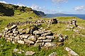
Sites of interest include the remains of a broch, the ruins of Brochel Castle, inscribed stones, abandoned crofting communities, and many walking paths.
There is a shop/post office located in Inverarish. Accommodation is available in the old manor of Raasay House, and at various B&Bs. There are significant numbers of incomers and holiday homes especially in the south of the island. This has helped to arrest the population decline from over 900 in 1803 to 194 in 2001. Some inhabitants belong to the Free Presbyterian Church of Scotland, which strictly observes the Sabbath. On Sundays there are no public services, the playground is closed and, until 2004, the ferry did not run.[11][12]
In early 2007 the Raasay Community Association signed a contract with a number of building contractors to construct a community centre, which hosted its first céilidh on 29 May 2010.[13][14] In 2008 construction began on a new £12 million ferry terminal at Churchton Bay, which was officially opened on 17 August 2010. Following the community buyout of Raasay House, a £3.5 million refurbishment was undertaken, leading to the temporary closure of the outdoor centre.[15] However, in the early hours of 18 January 2009 the building was severely damaged by fire.[16] Restoration work commenced in August 2010 but was suspended in November when the main contractor, ROK, went into administration.[17][18] Work restarted with a new contractor, Mansell, in late 2011. Raasay House was officially handed over to the community in March 2013[19] and in addition to the 4 star accommodation it provides it is also now an outdoor activity centre with a restaurant, bar and cafe.[9][20]
In September 2017 the Isle of Raasay distillery opened after the conversion of Borodale House.[21] One source described this as transforming the "derelict Gothic hotel ... into a modern whisky distillery, visitor centre and accommodation".[22] The company's Single malt Scotch was described by one source as the island's "first legal single malt" whisky. It released 7,500 bottles of the spirit in 2020, the first year that Raasay Single Malt became available.[23]
Flora and fauna
[edit]Raasay is home to the Raasay vole (Clethrionomys glareolus erica),[24] a subspecies of bank vole, which is darker and heavier than the mainland variety and found nowhere else in the world. It is possibly a survivor of a Scandinavian race. Murray (1973) states that a single specimen of a pine marten, otherwise missing from the Hebrides, was found on the island in 1971.[a] No other records for this species exist. Raasay is one of only four of the Inner Hebrides where mountain hares breed.[26] Raasay is regularly visited by white-tailed sea eagles and golden eagles and there are populations of otter, red deer and European rabbit (which were introduced by the island's proprietor in the 19th century). Stoat and weasel are found in small numbers as are water shrew.[3][27][28] It also supports a rich variety of plants, including red broomrape, dark red helleborine, mountain avens and numerous other saxifrages, orchids, alpines and ferns. The carline thistle (Carlina vulgaris) was apparently extant in the 1970s, but a recent survey found no evidence of its continued existence. There are several stands of mixed woodland.[3][29][b]
Prehistory
[edit]Between 1999 and 2004 a large scale archaeological project, Scotland's First Settlers, was undertaken in the Inner Sound to locate and examine sites relating to the Mesolithic period in the strait. The entire coastline of the Inner Sound together with its islands was walked by volunteers and archaeologists. On Raasay they found 14 caves and rock shelters with evidence of prehistoric habitation, in the form of both middens and walls. Only the site at Loch an Sgurra at the far north of Raasay was confirmed as Mesolithic on the basis of both the stone tools and radiocarbon dating.[30]
History
[edit]The spread of Scots culture from Dalriada north of Ardnamurchan is poorly understood and little is recorded of Raasay's early Christian period. The placename Kilmaluag suggests the presence of St Moluag in the late sixth century.[31]
Following Viking expeditions to the islands they called the Suðreyjar in the eighth century, Raasay became part of the Norse Kingdom of the Isles and for much of the period religious observance came under the jurisdiction of the Bishopric of the Isles.[32] The Hebrides were yielded to the Kingdom of Scotland as a result of the 1266 Treaty of Perth,[c] after which time control of the islands north of Ardnamurchan was in the hands of the Earls of Ross.[33] In addition to the name "Raasay" itself, placenames such as Arnish (eagle headland), Suidhisnis (seething headland) and Eyre (beach or sand spit) are a legacy of the Norse presence.[34]
15th to 17th century
[edit]
Tradition has it that Clan MacSween originally held title to Raasay but there is no written record of this.[35] It is known that the island was ruled by the MacLeods from 1518 when Gillecallum, younger son of the MacLeod Chief of Lewis was granted title.[3] Martin Martin visited towards the end of the 17th century and noted:
it has some wood on all the quarters of it, the whole is fitter for pasturage than cultivation, the ground being generally very unequal, but very well watered with rivulets and springs. There is a spring running down the face of a high rock on the east side of the isle; it petrifies into a white substance, of which very fine lime is made, and there is a great quantity of it. There is a quarry of good stone on the same side of the isle; there is abundance of caves on the west side, which serve to lodge several families, who for their convenience in grazing, fishing, &c., resort thither in the summer. On the west side, particularly near to the village Clachan, the shore abounds with smooth stones of different sizes, variegated all over. The same cattle, fowl, and fish are produced here that are found in the isle of Skye. There is a law observed by the natives that all their fishing lines must be of equal length, for the longest is always supposed to have best access to the fish, which would prove a disadvantage to such as might have shorter ones.
There are some forts in this isle, the highest is in the south end; it is a natural strength, and in form like the crown of a hat; it is called Dun-Cann, which the natives will needs have to be from one Canne, cousin to the king of Denmark. The other lies on the side, is an artificial fort, three stories high, and is called Castle Vreokle.[36]
Brochel Castle, as it is more commonly known, was built by the MacSweens in the 15th century on the north-east coast of Raasay. Latterly, it became a base for the MacLeod of Lewis's pirating activities prior to Calum Garbh's investiture there. The castle was inhabited until the death by drowning of the Chief Iain Garbh in 1671 and is now a ruin sitting atop a pinnacle. In the meantime the Macleods moved their seat to Raasay House at the south end of the island.[3][37]
18th century
[edit]Although Protestant, the MacLeods of Raasay supported Bonnie Prince Charlie during and after the Jacobite rising of 1745. After the defeat at the Battle of Culloden, the Prince spent 2 days hiding from the British troops on Raasay.[38][39] In conversation with Malcolm MacLeod of Raasay during his short stay on the island the Prince confided that although his life on the run was hard, he would rather live that way for ten years than be captured as he feared assassination. He seemed less aware of the risks his supporters ran. The atrocities perpetrated in the aftermath of Culloden were a shock to him. Of Cumberland he said: "Surely that man who calls himself a duke and pretends to be so great a general cannot be guilty of such cruelties. I cannot believe it."[40]
According to a 20 October 1752 letter to Robert Forbes by the Laird of Raasay, as a consequence of the island's support for the Jacobite cause and for having granted hospitality to the prince, the island was subjected to scorched earth tactics during two visits in July 1746 by troops of the Campbell of Argyll Militia under the command of General John Campbell and the Royal Navy crew of HMS Furnace under the command of Captain John Fergussone.[citation needed] One witness account states that the original Raasay House and many other dwellings were burnt down, all the islanders' livestock were confiscated and slaughtered, and two women were assaulted.[41] The Laird was afterwards taken prisoner by Captain Fergussone, transported aboard the Furnace to London, and held aboard a prison hulk anchored in the River Thames.[41] The Laird's allegations are also confirmed by a still extant letter from Captain Fergussone to his naval superior, Commodore Thomas Smith, and by a brief entry in the Furnace's ship's log, "Set Raasa Isle afire."[42]

In 1773 James Boswell and Samuel Johnson arrived on the island during their Hebridean tour. They visited Raasay House and Johnson wrote:
Our reception exceeded our expectations. We found nothing but civility, elegance, and plenty. After the usual refreshments, and the usual conversation, the evening came upon us. The carpet was then rolled off the floor; the musician was called, and the whole company was invited to dance, nor did ever fairies trip with greater alacrity. The general air of festivity, which predominated in this place, so far remote from all those regions which the mind has been used to contemplate as the mansions of pleasure, struck the imagination with a delightful surprise, analogous to that which is felt at an unexpected emersion from darkness into light.
When it was time to sup, the dance ceased, and six and thirty persons sat down to two tables in the same room. After supper the ladies sung Erse songs, to which I listened as an English audience to an Italian opera, delighted with the sound of words which I did not understand.[43]
Boswell went exploring and described the island as follows:
Having resolved to explore the island of Rasay, which could be done only on foot, I last night obtained my fellow-traveller’s permission to leave him for a day, he being unable to take so hardy a walk. Old Mr Malcolm M’Cleod, who had obligingly promised to accompany me, was at my bedside between five and six. I sprang up immediately, and he and I, attended by two other gentlemen, traversed the country during the whole of this day. Though we had passed over not less than four-and-twenty miles of very rugged ground, and had a Highland dance on the top of Dùn Can, the highest mountain in the island, we returned in the evening not at all fatigued, and piqued ourselves at not being outdone at the nightly ball by our less active friends, who had remained at home.
My survey of Rasay did not furnish much which can interest my readers; I shall therefore put into as short a compass as I can, the observations upon it, which I find registered in my journal. It is about fifteen English miles long, and four broad. On the south side is the laird’s family seat, situated on a pleasing low spot. The old tower of three stories, mentioned by Martin, was taken down soon after 1746, and a modern house supplies its place. There are very good grass-fields and corn-lands about it, well dressed. I observed, however, hardly any inclosures, except a good garden plentifully stocked with vegetables, and strawberries, raspberries, currants, &c.[44]
19th and 20th centuries
[edit].jpg)

In 1843 the last laird, John Macleod, was deep in debt and chose to emigrate to Tasmania[37] having sold Raasay for 35,000 guineas to George Rainy. After the Highland Potato Famine of the 1840s, the new owner decided to convert as much arable land as possible to large scale sheep farming. This required the removal of the islanders, and his solution was to ban marriage. Several townships were cleared including most of the inhabited areas of the east coast. Hallaig was emptied in 1852-54 and the ruins of at least 25 buildings remain visible.[45] North and South Screapadal are further north and contained at least 30 buildings when still inhabited.[46][47] Two boatloads of emigrants left for Portland in Australia in 1854 as a result, and another 165 left for the same destination in 1865. The estate was then sold to Edward Wood, and conflicts between the laird and the islanders grew as he decided to turn the island over to sporting purposes.[48] Near Oskaig, there is a row of six houses which are known as Manitoba.[49] Locals believe that this was a gathering place for people about to embark on emigrating to Canada in the late 19th century.
On 20 September 1862 the steamship Irishman ran aground on "Skernataid Rock" between Raasay and Scalpay. A 9.2 m (30 ft 2 in) vessel Spindrift is also recorded as having become jammed under the ferry pier at the sound end of the island and broken in two by the rising tide at an unspecified date.[50][d]
William Baird and Company signed a deed to purchase the estate of the Island of Raasay on 28 December 1910. The sale completed on 15 May 1911.[51]
In May 1921, a group of crofters from Rona landed on Raasay and attempted to re-occupy their ancestral land. These so-called "Raasay Raiders" were arrested, tried and given prison sentences, but public support for them was strong and they were eventually freed and allowed to remain on Raasay.
The island was purchased by the government in 1922 after the mine closed. In 1949 The Forestry Commission was granted land bringing much-needed employment, and in 1956 The North of Scotland Hydro-Electric Board delivered mains electricity to the island.[52] The power was generated by Storr Lochs Hydro-Electric Scheme, which was commissioned in 1952 and upgraded in 1956. Local residents and invited guests met at Balmeanach, on Skye, on 14 March 1956. Major General Harry Macdonald, who owned the Braes estate, operated the switch, and rockets were fired from Raasay to confirm that electricity had arrived through the undersea cable, which ran from An Aird in Braes to Suishnish. The guests were then transported to Raasay in fishing boats to complete the celebrations.[53] In the 1960s Raasay House and various other properties were purchased by John Green, a doctor residing in Sussex who visited the island only once and whose lack of interest in it earned him the sobriquet "Dr No". Having purchased the property for £8,000 he sold it to the Highlands and Islands Development Board in 1979 for £135,000.[3][37][54][55]
The Iron Mine
[edit]
Nicolson reported an early bloomery on the island.[56] The next record of ironstone on Raasay was by HB Woodward in 1893.[57] Stead investigated the outcrop in 1909 and the subsequent analysis by Tatlock convinced Baird's to buy the island the following year (with completion in 1912).[58]
Baird's original plan was for a railway from the outcrop site down to just south of Suisnish point[e] with the erection of five kilns. Objections led to the plan being revised for two kilns further south, where the current pier is.[51] This pier was a public pier with landing charges regulated by government order.[59] By the outbreak of war Baird's had completed the pier (constructed by Robert McAlpine & Sons), kilns, railway and "other works".[60][61]
To house the workforce Baird's planned the village of Inverarish Houses, today known as Inverarish Terrace. The village consists of two facing rows of houses, each row being two terraces of 16 houses each. Between the terraces is a broad open area. Numbers 1–32 are the western row, 33–64 the eastern. The lower, southern terraces were built first (1–16 and 33–48) between 1912 and 1913. The first terraces were stone built and by 1914–15 were about half occupied.[60] By the time of the 1915–16 valuation some of numbers 1–16 were unoccupied, just over half of numbers 33–48 were occupied and the newly built brick terrace of numbers 17–32 were also vacant.[62] The unoccupied houses were caused by many of the labour force being called to the colours.
With the introduction of unrestricted submarine warfare in 1916 the Ministry of Munitions became concerned about the availability of foreign iron ore.[63] Baird's were one company amongst others which opened up domestic mines in order to supply the war effort. In May 1916 Baird's signed an agreement to run the mine on behalf of the Ministry, although there was a minor skirmish over the amount of processing to be done on the island.[64] This northern part of the village was converted into a prisoner-of-war camp by the simple expedient of building a barbed wire fence around it and erecting sentry boxes and arc lamps at the corners. The first prisoners were on the island by June and were housed in the upper part of the village, numbers 17–32 and the now completed 49–64.[62]
Population
[edit]
| Year | 1780 | 1803 | 1841 | 1881 | 1891 | 1931 | 1961 | 1981 | 1991 | 2001 | 2011 | 2022[2] |
|---|---|---|---|---|---|---|---|---|---|---|---|---|
| Population | 400 + | 900 + | 676 | 532 | 489 | 377 | 223 | 152 | 163 | 194 | 161 | 187 |
In 2001 Raasay had the lowest percentage of children of any populated Scottish island,[3] and the island's population fell by over 16% since that time to the date of the 2011 census.[65][66] During the same period Scottish island populations as a whole grew by 4% to 103,702.[67] With 36% in the 2001 census there was still a relatively high density of Gaelic speakers (down from over 75% in 1901 and 1921).[68] By 2022 the population had risen a little again to 187.[2]
Culture and the arts
[edit]Piping tradition
[edit]John MacKay, born on Raasay in 1767, was supported by the MacLeod Chief as the foremost island piper of his day and an inheritor of the MacCrimmon tradition. His son Angus published a collection of pibroch music in staff notation and was the first Piper to the Sovereign.[37]
Sorley MacLean
[edit]
The poet Sorley MacLean was born in Osgaig, a small crofting community on the west coast of the island; perhaps his most famous poem is about Hallaig, an abandoned community on the east coast. MacLean's writings often combine an ancient traditional awareness, with a modernist political outlook, in which Raasay, and the areas adjacent to it are frequently referenced. But while MacLean's work dwells on the brutality of war, of the Highland Clearances and modern exploitation, he also writes about nature. Thus, although the Clearances leave an empty landscape populated only by the ghosts of those evicted or forced to emigrate, "Time, the deer, is in the Wood of Hallaig".[69]
Calum's Road
[edit]The two miles (3 km) of road between Brochel Castle and Arnish were built using hand-tools by Calum MacLeod over ten years. Only when complete was the road surfaced by the local council; by then Calum and his wife were the last inhabitants of Arnish. Calum's Road has been commemorated in music both by Capercaillie on their 1988 album The Blood is Strong[70] and by Runrig in Wall of China from the album The Stamping Ground, as well as in a book by Roger Hutchinson.[71] The BBC Radio 4 drama Calum's Road, based on Hutchinson's book and dramatised by Colin MacDonald, was first broadcast on 5 October 2013 starring Ian McDiarmid as Calum MacLeod.[72]
Harrison Birtwistle
[edit]The composer Sir Harrison Birtwistle lived on Raasay from 1975 to 1983.[73] His Duets for Storab, takes its name from Storab, a Viking prince who was shipwrecked and sought refuge on Raasay.[74] Birtwistle's string quartet, The Tree of Strings, written in 2007, takes its title from a poem by Sorley MacLean.[75]
See also
[edit]References
[edit]Notes
[edit]- ^ Murray states "The pine marten, which has been absent from the Hebrides for a hundred years, reappeared on Raasay in 1971, when a single specimen was identified beyond doubt". He attributes this to a 1972 report in The Scotsman by Alison Lambie.[25]
- ^ For a comprehensive flora of the island see Bungard 2009
- ^ For the text of the treaty and a translation from the Latin to English see "Agreement between Magnus IV and Alexander III, 1266" Manx Society. IV, VII & IX. Retrieved 10 April 2016.
- ^ Baird suggests "Skernataid Rock" may be Sgeir Thraid at NG628334
- ^ Contemporary spelling was Suishnish
Citations
[edit]- ^ a b Area and population ranks: there are c. 300 islands over 20 ha in extent. 93 permanently inhabited islands were listed in the 2011 census and 101 such islands in 2022.
- ^ a b c d "Scottish Islands Data Dashboard". RESAS/Scottish Government. 2025. p. 6. Retrieved 1 June 2025.
- ^ a b c d e f g h Haswell-Smith 2004.
- ^ Haswell-Smith 2004, pp. 161–166.
- ^ a b c Ordnance Survey. OS Maps Online (Map). 1:25,000. Leisure.
- ^ Mac an Tàilleir 2003.
- ^ Gifford, Dunnigan & MacGillivray 2002.
- ^ Keay & Keay 1994.
- ^ a b Raasay House 2016.
- ^ Gillen 2003, p. 176.
- ^ MacLeod 2004, p. 182.
- ^ BBC 2004.
- ^ Raasay Community Association 2007.
- ^ Dualchas Architects 2012.
- ^ Highland Council 2008.
- ^ The Scotsman 2009.
- ^ Ross 2010.
- ^ BBC 2010.
- ^ Raasay House 2013.
- ^ Visit Scotland 2016.
- ^ Isle of Raasay Distillery 2020.
- ^ The lesser known Scottish islands to dream about visiting when lockdown is over
- ^ Kanik 2020.
- ^ funet.fi 2016.
- ^ Murray 1973, pp. 108–109.
- ^ Darling & Boyd 1969, p. 71.
- ^ Murray 1973, p. 107.
- ^ Highland Biological Recording Group.
- ^ Slack, Alf "Flora" in Slesser 1970, p. 57
- ^ Hardy & Wickham-Jones 2009.
- ^ Rixson 2001, p. 19.
- ^ MacLeod 2004, p. 12.
- ^ MacLeod 2004, p. 13.
- ^ Mac an Tàilleir 2003, pp. 8, 47, 110.
- ^ MacLeod 2004, p. 17.
- ^ Martin 1716, p. 163.
- ^ a b c d Keay & Keay 1994, p. 797.
- ^ Murray 1966, p. 153.
- ^ Fairweather 2015.
- ^ Forster 1975, p. 169.
- ^ a b Forbes, Robert (1895). Paton, Henry (ed.). The Lyon in mourning : or, A collection of speeches, letters, journals etc. relative to the affairs of Prince Charles Edward Stuart. Edinburgh, Printed at the University press by T. and A. Constable for the Scottish history society. Volume 3, pp. 123-127.
- ^ John S. Gibson (1967), Ships of the '45: The Rescue of the Young Pretender, Hutchinson & Co. London. With a Preface by Sir James Fergusson of Kilkerran, Bart., L.L.D. p. 30.
- ^ Johnson 1775, pp. 85–86.
- ^ Boswell 1785, Sunday, 5 September.
- ^ "Hallaig". Gazetteer for Scotland. Retrieved 2 March 2024.
- ^ "North Screapadal". Gazetteer for Scotland. Retrieved 2 March 2024.
- ^ "South Screapadal". Gazetteer for Scotland. Retrieved 2 March 2024.
- ^ Cooper 1979, pp. 142–143.
- ^ Historic Environment Scotland NG53NW 56.
- ^ Baird 1995, p. 234.
- ^ a b Draper & Draper 2003, p. 5.
- ^ MacLeod 2004, p. 173.
- ^ "Isle of Raasay Hydro-Electric Switch-On". Am Baile - Highland History and Culture. Archived from the original on 18 June 2023.
- ^ MacLeod 2004, pp. 174–183.
- ^ The Glasgow Herald 1981, p. 15.
- ^ Nicolson 1936, p. 78, cited by; Draper & Draper 2003, p. 4.
- ^ Woodward 1914, p. 164, cited by; Draper & Draper 2003, p. 4.
- ^ Draper & Draper 2003, pp. 4–5.
- ^ Draper & Draper 2003, pp. 6.
- ^ a b Draper & Draper 2003, pp. 7.
- ^ Draper & Draper 2003, pp. 16.
- ^ a b Draper & Draper 2003, p. 8.
- ^ 'History of the Ministry of Munitions' quoted in Draper & Draper 2003, p. 9
- ^ Draper & Draper 2003, p. 15.
- ^ National Records of Scotland 2013.
- ^ General Register Office.
- ^ BBC 2013.
- ^ Mac an Tàilleir 2005.
- ^ MacLean 2002.
- ^ Shaw 1987.
- ^ Hutchinson 2006.
- ^ BBC Radio 4 2014.
- ^ Service 2012.
- ^ Braun.
- ^ Clements 2012.
Bibliography
[edit]- Baird, Bob (1995), Shipwrecks of the West of Scotland, Glasgow: Nekton Books, ISBN 1-897995-02-4
- BBC (2 May 2004), "Sabbath ferry service sets sail", BBC News, retrieved 26 March 2016
- BBC (17 November 2010), "Rok boss tells of bid to buyout construction division", BBC News, retrieved 27 March 2016
- BBC (15 August 2013), "Scotland's 2011 census: Island living on the rise", BBC News, retrieved 16 April 2016
- Calum's Road, BBC Radio 4, 18 July 2014, retrieved 17 April 2016
- Boswell, James (1785), Journal of a Tour to the Hebrides with Samuel Johnson, LL.D, archived from the original on 12 August 2008
- Braun, Gerhard (ed.), Sir Harrison Birtwistle, Duets for Storab, Universal Edition
- Bungard, Stephen J. (2009), "A Flora of Raasay and Rona", waitrose.com, retrieved 19 August 2009
- Clements, Andrew (2 May 2012), "Birtwistle: Nine Movements; The Tree of Strings – review", The Guardian, retrieved 17 April 2016
- Cooper, Derek (1979), Road to the Isles: Travellers in the Hebrides 1770–1914, London: Routledge & Kegan Paul, ISBN 978-0-7100-0256-3
- Darling, Frank Fraser; Boyd, J Morton (1969), Natural History in the Highlands and Islands, London: Collins, ISBN 978-0-00-213092-9
- Draper, Laurence; Draper, Pamela (2003) [first published 1990], The Raasay Iron Mine, Dingwall: Laurence and Pamela Draper, ISBN 0-9514870-0-0
- Dualchas Architects (2012), Community Centre, Isle of Raasay, archived from the original on 19 March 2016, retrieved 27 March 2016
- Fairweather, Nick (2015), Exploring Raasay
- Forster, Margaret (1975), The Rash Adventurer: The Rise and Fall of Charles Edward Stuart, St Albans: Panther, ISBN 978-0-586-04082-9
- FUNET species list: Rodentia, funet.fi, retrieved 3 April 2016
- General Register Office for Scotland (28 November 2003) Scotland's Census 2001 – Occasional Paper No 10: Statistics for Inhabited Islands. Retrieved 26 February 2012.
- Gifford, Douglas; Dunnigan, Sarah; MacGillivray, Alan, eds. (2002), Scottish Literature: In English and Scots, Edinburgh University Press, archived from the original on 13 January 2005, retrieved 2 June 2007
- Gillen, Con (2003), Geology and landscapes of Scotland, Harpenden: Terra, ISBN 978-1-903544-09-9
- The Glasgow Herald (25 May 1981), Mother and daughter to run new hotel on Raasay, retrieved 20 December 2020
- Hardy, Karen; Wickham-Jones, Caroline (1 January 2009), "Mesolithic and later sites around the Inner Sound, Scotland the work of the Scotland's First Settlers project 1998-2004", Scottish Archaeological Internet Reports, 31, retrieved 15 August 2021
- Haswell-Smith, Hamish (2004). The Scottish Islands. Edinburgh: Canongate. ISBN 978-1-84195-454-7.
- Highland Biological Recording Group, Mammal Atlas, archived from the original on 12 June 2009, retrieved 19 August 2009
- Highland Council (7 March 2008), Work commences on Raasay Ferry Terminal, archived from the original on 1 May 2008, retrieved 12 May 2008
- Historic Environment Scotland, "Raasay, Oskaig (Site no. NG53NW 56)", retrieved 15 November 2021
- Hutchinson, Roger (2006), Calum's Road, Edinburgh: Birlinn, ISBN 978-1-84158-447-8
- Isle of Raasay Distillery (2020), Isle of Raasay Distillery, retrieved 20 December 2020
- Johnson, Samuel (1775), A Journey to the Western Islands of Scotland (1924 ed.), London: Chapman & Dodd
- Kanik, Hannah (18 December 2020), First legal Isle of Raasay single malt unveiled recently, The Whiskey Wash, retrieved 20 December 2020
- Keay, John; Keay, Julia (1994), Collins Encyclopaedia of Scotland, London: HarperCollins, ISBN 978-0-00-255082-6
- Mac an Tàilleir, Iain (2003), Placenames collected by Iain Mac an Tailleir (PDF) (pdf), vol. part 5: Pabay – Yoker, The Scottish Parliament, retrieved 25 March 2016
- Mac an Tàilleir, Iain (18 April 2005), 1901–2001 Gaelic in the Census (PowerPoint) (542nd ed.), Linguae Celticae, archived from the original on 22 October 2007, retrieved 16 April 2016
- MacLean, Sorley (20 November 2002) [First published 1954], "Hallaig", The Guardian, translated by Heaney, Seamus, retrieved 16 April 2016 Also see The Guardian
- MacLeod, Norma (2004), Raasay: the island and its people, Edinburgh: Birlinn, ISBN 978-1-84158-280-1
- Martin, Martin (1716), A Description of The Western Islands of Scotland (2nd ed.), London: A. Bell, p. 163, retrieved 10 April 2016
- Murray, W. H. (1966), The Hebrides, London: Heinemann, OCLC 4998389
- Murray, W. H. (1973), The Islands of Western Scotland, London: Eyre Methuen, ISBN 0-413-30380-2
- Nicolson, Alexander (1936), Handbook to the Isle of Skye, Glasgow: Celtic Press
- National Records of Scotland (15 August 2013), "2011 Census: First Results on Population and Household Estimates for Scotland – Release 1C (Part Two)" (PDF), Statistical Bulletin, vol. SG/2013/126, retrieved 11 April 2017
- Ordnance Survey (2012), OS24: Raasay & Applecross (Loch Torridon & Plockton), Landranger, Ordnance Survey, ISBN 978-0-319-23110-4
- Raasay Community Association (March 2007), RCA – News: March 2007, archived from the original on 3 March 2016, retrieved 27 March 2016
- Raasay House (16 April 2013), "Open at Last", Archive.org, archived from the original on 27 September 2013, retrieved 16 April 2016
- Raasay House (25 March 2016), "Historic", Raasay House, retrieved 25 March 2016
- Rixson, Denis (2001), The Small Isles: Canna, Rum, Eigg and Muck, Edinburgh: Birlinn, ISBN 978-1-84158-154-5
- Ross, David (4 August 2010), "Restoration work starts on fire-ravaged Raasay House", The Herald, Glasgow
- The Scotsman (18 January 2009), Blaze devastates historic isle house, Johnston Publishing, retrieved 27 March 2016
- Service, Tom (29 June 2012), "Harrison Birtwistle: the music of myth", The Guardian, retrieved 17 April 2012
- Shaw, Donald (1987), "Calum's Road", nigelgatherer.com, retrieved 27 October 2008
- Slesser, Malcolm (1970), The Island of Skye, Edinburgh: Scottish Mountaineering Trust, ISBN 978-0-901516-26-8
- Visit Scotland (2016), Accommodation at Raasay House, retrieved 3 April 2016
- Woodward, HB (1914), "Notes on the Geology of Raasay", Transactions of the Edinburgh Geological Society, vol. X
Further reading
[edit]- Mackenzie, Julia (2000), Whirligig Beetles And Tackety Boots, Bedale: Blaisdon, ISBN 978-1-902838-07-6
- Murray, C. W.; Birks, H. J. B. (2005), The Botanist in Skye and Adjacent Islands: An Annotated Check-list of the Vascular Plants of the Islands of Skye, Raasay, Rona, Rum, Eigg, Muck, Canna, Scarpay and Soay, Murray and Birks, ISBN 0-9548971-0-2
- Nicholson, John (2002), I Remember: Memories of Raasay, Edinburgh: Birlinn
- Sharpe, Richard (1977), Raasay A Study in Island History, London: Grant and Cutler, ISBN 0-7293-0130-3
- Sharpe, Richard (1978), Raasay A Study in Island History Documents And Sources, London: Grant and Cutler, ISBN 0-7293-0060-9
- Stack, Prunella (1979), Island Quest. The Inner Hebrides, London: Collins/Harvill Press, ISBN 0-00-262323-4
External links
[edit]Inhabited islands of the Hebrides | ||
|---|---|---|
| Inner Hebrides |  | |
| Outer Hebrides | ||
|  | ||||||||||||||||
|
| |||||||||||||||||
| |||||||||||||||||
| |||||||||||||||||
| |||||||||||||||||
| |||||||||||||||||
| |||||||||||||||||
| |||||||||||||||||
Raasay
View on GrokipediaRaasay (Scottish Gaelic: Ratharsair) is an island in the Inner Hebrides of Scotland, positioned off the east coast of the Isle of Skye between it and the mainland.[1] The island extends approximately 14 miles in length and up to 3 miles in width, encompassing rugged terrain dominated by basalt columns, moorlands, and coastal cliffs.[2] Its name derives from Norse origins, translating to "Island of the Roe Deer," reflecting Viking influence from the 8th century onward.[2] With a resident population of about 179, Raasay maintains a sparse settlement primarily along its eastern shore, supporting a community reliant on fishing, tourism, and small-scale enterprises like a distillery established in recent decades.[3][4] Historically, Raasay served as a stronghold for clans including the MacSween and later the MacLeods of Lewis, who constructed Brochel Castle in the 15th century as their chief residence before relocating southward.[5] The island experienced 19th-century iron ore mining, which briefly stimulated economic activity but ultimately declined due to logistical challenges and market shifts.[2] Highland Clearances in the 19th century led to significant depopulation, particularly in areas like Hallaig, an event immortalized in the poetry of Raasay-born Gaelic modernist Sorley MacLean (1911–1996), whose works evoke the island's cultural heritage and loss.[2][6] Today, Raasay's defining characteristics include its unspoiled natural landscape, Gaelic linguistic traditions, and efforts to address housing shortages amid modest population stability.[3]
Geography
Location and topography
Raasay is an island in the Inner Hebrides archipelago of Scotland, positioned off the eastern coast of the Isle of Skye across the Sound of Raasay and facing the Applecross peninsula on the mainland to the east.[2] Its central coordinates are approximately 57°22′N 6°02′W.[7] The island spans roughly 14 miles (23 km) from north to south and reaches a maximum width of about 3 miles (5 km) east to west.[2] [8] The topography of Raasay is characterized by rugged, varied terrain, including high moorland, steep hills, and coastal cliffs, with much of the interior consisting of marginal upland suitable primarily for rough grazing.[2] The island's highest elevation is Dùn Caan, a distinctive flat-topped volcanic peak rising to 443 metres (1,453 feet) near the center, offering panoramic views of surrounding seas and islands on clear days.[9] [10] Northern and central areas feature elevated ground, while the southern portion includes lower-lying coastal plains, freshwater lochs, and pockets of woodland.[2] The overall relief contributes to a landscape of dramatic contrasts, from exposed hilltops to sheltered bays and sandy beaches along the shores.[11]Geology
Raasay's geology encompasses rock formations spanning nearly three billion years, from Archaean Lewisian gneiss to Quaternary superficial deposits, juxtaposed by major faults such as the Minch Fault and local thrusts.[12][13] The northern third of the island consists primarily of Lewisian gneiss, migmatitic biotite-hornblende gneisses of Archaean to Paleoproterozoic age (over 2.7 billion years old), locally intruded by basic and ultrabasic rocks and overlain unconformably by late Precambrian Torridonian sandstones and conglomerates up to several hundred meters thick.[14][15] These Precambrian units form rugged terrain, with the gneiss exhibiting foliation and the Torridonian showing cross-bedding indicative of fluvial and alluvial deposition.[16] Mesozoic sediments dominate the central and eastern parts, comprising Lower Jurassic strata of the Hebridean Basin. The sequence begins with the Pabay Shale Formation (shales and mudstones, 10-20 m thick), succeeded by the Scalpa Sandstone Formation (quartzitic sandstones, 60-126 m thick, ranging from mid-Sinemurian Ibex Zone to lower Pliensbachian Tenuicostatum Zone), Portree Shale Formation (organic-rich shales, 1-14 m), and Raasay Ironstone Formation (ferruginous oolitic limestones and shales with hardgrounds and hiatuses, 0.3-2.4 m thick).[17][18][19] These units dip gently westward and contain marine fossils, reflecting shallow-shelf environments interrupted by tectonic activity.[20] Paleogene igneous rocks intrude the Mesozoic sequence in the south, including a large granitic body and basic sills of basalt and dolerite associated with the British Tertiary Igneous Province. Dùn Caan, the island's summit at 443 m, comprises a Tertiary volcanic plug of phonolite with surrounding basaltic crags and tuffs, formed during Oligocene-Miocene volcanism.[12][15][21] Quaternary features include glacial till, raised beaches, and neotectonic fault movements, such as along the Beinn na Leac Fault, which displaces Jurassic strata by up to 161 m vertically. Tectonic fissures in Jurassic sandstones, up to 200 m deep, result from Mesozoic-Cenozoic extension.[13][20][22] The island's varied lithologies contribute to its designation as a Site of Special Scientific Interest for geological interest.[21]Natural Environment
Climate
Raasay possesses a temperate oceanic climate moderated by the North Atlantic Drift, which maintains mild conditions with limited temperature extremes despite its northern latitude. Winters are wet and windy, while summers remain cool and relatively pleasant, though overcast skies and drizzle are common year-round. High humidity levels, averaging around 80-85%, contribute to the persistent dampness.[23][24] Mean annual air temperature stands at approximately 8.6–9°C, with monthly averages fluctuating from 4°C in January (daytime highs near 7°C, nighttime lows around 2°C) to 14°C in July (highs up to 16–17°C). Air frost occurs on roughly 20–30 days annually, primarily in winter, and snowfall totals about 19 cm per year, rarely accumulating deeply due to rapid thawing. Extreme lows have reached -7°C in February, but sub-zero temperatures are infrequent.[25][26][27] Precipitation averages 1500–1900 mm annually, exceeding Scotland's national figure of about 1570 mm, with rain falling on over 200 days per year and winters seeing the heaviest totals (up to 180–200 mm monthly). Gale-force winds, often exceeding 30–40 km/h, are prevalent from October to March, influenced by Atlantic depressions. Over the past two decades, annual temperatures have trended above historical norms, and rainfall intensity has increased, aligning with observed regional shifts.[23][27][25][28]Flora and fauna
Raasay's flora encompasses a range of upland and coastal habitats, including dwarf shrub heath, blanket bog, acid grasslands, and calcareous grasslands featuring the internationally rare Agrostis-Festuca-Thymus community around Dùn Caan.[21] Woodlands, particularly along the eastern coastal strip, consist of upland oak-birch-hazel stands with sessile oak, alder, rowan, grey willow, aspen, ash, and wych elm; ground flora includes calcicolous species, ferns such as lemon-scented fern (Oreopteris limbosperma), beech fern (Phegopteris connectilis), scaly male-fern (Dryopteris affinis), Wilson's filmy-fern (Hymenophyllum wilsonii), and green spleenwort (Asplenium trichomanes), alongside mosses, liverworts, and nationally scarce lichens.[21][29] Rare vascular plants documented include moss campion (Silene acaulis), alpine meadow-rue (Thalictrum alpinum), hoary whitlowgrass (Draba incana), dark-red helleborine (Epipactis atrorubens), rock whitebeam (Sorbus rupicola), mountain avens (Dryas octopetala), thyme broomrape (Orobanche alba), and slender-leaved pondweed (Potamogeton filiformis) in dystrophic and oligotrophic lochs.[21] Additional common elements comprise bracken, great horsetail (Equisetum telmateia), royal fern (Osmunda regalis), and various orchids, with small adder's-tongue fern (Ophioglossum azolium) recorded at multiple sites since 2022.[21][30] Faunal diversity features the endemic Raasay vole (Clethrionomys glareolus erica), a subspecies of bank vole distinguished by darker pelage and greater mass, considered a potential survivor of Pleistocene Scandinavian lineages.[31][32] Terrestrial mammals include red deer (Cervus elaphus), mountain hares (Lepus timidus), otters (Lutra lutra), and bats, while surrounding waters host grey seals (Halichoerus grypus), common seals (Phoca vitulina), dolphins, and porpoises (Phocoena phocoena).[31] Birds comprise raptors such as white-tailed sea eagles (Haliaeetus albicilla) and golden eagles (Aquila chrysaetos), with coastal and wader species like oystercatchers (Haematopus ostralegus), curlews (Numenius arquata), red-throated divers (Gavia stellata), northern divers (Gavia immer), shags (Phalacrocorax aristotelis), and cormorants (Phalacrocorax carbo).[31] Invertebrates in lochs include water beetles such as Potamonectes griseostriatus and two other notable species in acid pools.[21] Biodiversity in the Raasay SSSI, spanning the eastern seaboard from Eyre to South Screapadal, is threatened by heavy grazing from sheep, cattle, deer, and rabbits, which hinders woodland regeneration and alters grasslands; bracken encroachment; and muirburning, which promotes invasive spread and degrades heath.[29] Management emphasizes grazing control, bracken suppression, adherence to the Muirburn Code, and preservation of dead wood to support regeneration.[29]Prehistory and Archaeology
Early human activity
The earliest evidence of human activity on Raasay dates to the Mesolithic period, approximately 10,000 years ago, following the retreat of the last Ice Age glaciers.[33] This era represents hunter-gatherer societies exploiting coastal and inland resources in the Inner Hebrides, with Raasay's rugged terrain and proximity to marine environments facilitating seasonal occupations. The Scotland's First Settlers project (1998–2004), a systematic survey of the Inner Sound region between Skye and the mainland, identified key Mesolithic traces on the island through pedestrian surveys, test-pitting, and analysis of coastal middens and rock shelters.[34] [35] Archaeological findings include at least two rock shelters containing middens—accumulations of shells, bones, and lithic artifacts indicative of repeated human use for processing marine resources like shellfish and fishing. One notable site is the rock shelter and midden at Loch a' Sguirr, discovered by the project team, which yielded evidence of tool-making and food preparation activities consistent with mobile Mesolithic groups.[36] [37] These shelters, often with associated walls or hearths, suggest short-term camps rather than permanent settlements, aligning with broader patterns of low-density, resource-focused exploitation in western Scotland during the early Holocene.[38] Evidence for the subsequent Neolithic period (c. 4000–2500 BC), marked by farming, polished stone tools, and megalithic structures elsewhere in the Hebrides, remains scarce or absent on Raasay based on current surveys. Pollen and charcoal analyses from nearby northeast Raasay sites indicate vegetation changes possibly linked to early land management, but no definitive Neolithic artifacts or monuments, such as chambered tombs, have been confirmed.[39] This paucity may reflect limited survey coverage, post-glacial erosion, or Raasay's role as a peripheral foraging outpost rather than an agricultural hub, contrasting with denser Neolithic evidence on adjacent Skye.[40] Transition to Bronze Age activity, including possible burial or ritual sites, is inferred regionally but lacks specific Raasay attributions in available data.[41]Key sites and artifacts
Dun Borodale, an Iron Age dun located 160m west-southwest of the Old Free Church Manse, represents a fortified settlement with characteristics of a semi-broch, featuring internal dimensions of approximately 11.4m by 8m within walls up to 3.5m thick in places.[42] The structure includes galleries and steps indicative of defensive architecture typical of Atlantic roundhouses from around 850 BC to 500 AD, and it is designated as a Scheduled Ancient Monument.[42] Archaeological surveys have documented its upstanding remains on a commanding hilltop position about 80m above sea level.[33] Uamh nan Ramh, known as the Cave of the Oars, is an Iron Age souterrain situated above Churchton Bay, roughly 250m southeast of Raasay House.[43] This underground passage, approximately 17m long, was constructed by roofing a natural cleft with lintel stones, likely serving storage or refuge purposes during the period circa 850 BC to 500 AD; it is also a Scheduled Ancient Monument.[43] The site was noted in 1773 by visitors James Boswell and Samuel Johnson, who described its use for concealing boat oars.[44] Prehistoric habitation evidence includes at least 14 caves and rockshelters with middens and structural walls indicating Mesolithic activity around 10,000 BC, alongside Neolithic and Bronze Age cairns at sites like Eyre for burials, and scattered hut circles representing round houses about 7.5m in diameter.[33] Surveys by the Association of Certificated Field Archaeologists have identified over 2,000 features island-wide, including these prehistoric elements.[33] A notable early artifact is the Pictish symbol stone, a Class I slab standing 1.5m high, discovered near Clachan harbor in 1800 and relocated north of Raasay House.[45] Carved circa 650–700 AD, its front face bears a Chi-Rho cross (an early Christian monogram), a sideways tuning fork, and a crescent-and-V-rod symbol, making it one of only nine such stones recorded in western Scotland.[45] [46] Additionally, a separate Chi-Rho cross is incised on a rocky outcrop 310m southwest of Raasay House, dating to the second half of the 6th century and symbolizing early Christian influence in the region; this site forms part of a Scheduled Monument that also includes a later Napoleonic battery.[47]History
Medieval and clan period (pre-18th century)
Following Viking expeditions to the Hebrides in the eighth century, Raasay formed part of the Norse Kingdom of the Isles, known as Suðreyjar, under Scandinavian control that persisted until the Treaty of Perth in 1266 ceded the islands to the Kingdom of Scotland.[48][8] The island's name derives from Norse origins, reflecting this prolonged Viking influence.[49] In the post-Norse medieval era, Raasay was traditionally held by Clan MacSween, a Gaelic kindred with lordships in western Scotland.[2] Ownership transferred in 1518 to Calum Garbh MacLeod, second son of Malcolm MacLeod, the ninth chief of the MacLeods of Lewis, establishing the MacLeods of Raasay as a distinct branch of that clan.[2][50] Calum Garbh, also known as Mac Gille Chaluim, constructed Brochel Castle around this period as the clan's primary stronghold, perched on a defensive volcanic stack in the island's northeast, likely in the early 1500s.[5][51] The MacLeods of Raasay governed the island through the sixteenth and seventeenth centuries, maintaining feudal authority amid the turbulent clan dynamics of the Inner Hebrides, including feuds and alliances with neighboring MacLeods of Skye and Lewis.[52] Brochel served as their residence until at least the mid-seventeenth century, when it fell into disuse by 1671, symbolizing the clan's early medieval foothold before later shifts to more central estates.[53][54] The period was marked by Gaelic-speaking Highland society, with the clan system enforcing loyalty, land tenure, and military obligations under tacksmen and tenants.[48]18th and 19th centuries: Jacobite era and clearances
During the Jacobite rising of 1745, the MacLeods of Raasay, a branch of Clan MacLeod distinct from the Harris line, provided support to the Stuart pretender Charles Edward Stuart despite their Protestant affiliations.[52] Malcolm MacLeod, the 10th laird, mobilized clansmen who fought on the Jacobite side at the Battle of Culloden on 16 April 1746.[55] Following the Jacobite defeat, Charles Edward Stuart landed on Raasay on 2 July 1746, residing there for two days under MacLeod protection before crossing to Skye.[56] British forces, seeking reprisals for aiding the fugitive prince, burned Raasay House later that year, destroying the laird's residence.[57] The 18th century saw continued economic pressures on the island's proprietors, culminating in the sale of Raasay in 1843 by John MacLeod, the 13th and final laird, who had accumulated heavy debts and subsequently emigrated to Tasmania.[58] The buyer, George Rainy, a lawyer and former slave compensation recipient, implemented policies aligned with broader Highland landlord practices favoring sheep farming over subsistence tenancy.[59] Rainy's tenure marked the peak of clearances on Raasay, with mass evictions beginning in 1853 targeting fourteen southern townships to consolidate land for grazing.[49][60] These evictions displaced hundreds of tenants, reducing Raasay's population from over 1,000 in the early 19th century to under 600 by the 1860s, as families were compelled to relocate to marginal northern crofts or emigrate.[60][61] Sites such as Screapadal and Hallaig were among those abandoned, their ruins evidencing the shift from communal arable farming to extensive pastoralism driven by market demands for wool.[49][5]Industrial developments: The iron mine
In May 1911, William Baird and Company Limited, ironmasters based in Coatbridge, acquired the Isle of Raasay Estate specifically to exploit deposits of iron ore identified on the island.[62] Development of the mining infrastructure commenced in 1912, including the construction of worker housing at Inverarish, where 64 terraced houses formed the core of a new mining village to accommodate the labor force.[63] [64] The principal mining operations were centered at Inverarish in the southwest of the island, targeting south-facing slopes from elevations of around 210 meters down to sea level, with associated railways facilitating ore transport.[65] The outbreak of the First World War in 1914 coincided with the mine nearing readiness for full production, prompting accelerated extraction to meet wartime steel demands despite the ore's low quality and erratic outcrop yields.[66] Initial surface production began in August 1916 at 50 tons, rising to 220 tons the following month before halting for approximately a year; calcining of ore to remove impurities started in September 1916 and continued until February 1917.[67] [68] The workforce included local islanders, mainland British miners, and notably around 260 German prisoners of war, whose labor was sanctioned under international treaties of the era to support the Allied effort.[68] Processed ore was shipped from Raasay to facilities like Ravenscraig on the mainland for smelting.[66] Post-war, iron ore extraction ceased due to the ore's marginal viability outside strategic wartime needs, though elements of the site, including railways, remained in use until 1942.[69] The complex, comprising mine workings, kilns, and ancillary structures, stands as a scheduled monument recognized for its association with World War I industrial mobilization and coherent preservation of early 20th-century mining technology.[68]20th century: Wars, depopulation, and revival
The iron mine at Inverarish, which had been sporadically active in the 19th century, saw renewed commercial extraction beginning in 1912 under the Scottish Iron Mining and Smelting Company, owned by William Baird and Company, targeting low-grade oolitic iron ore deposits.[67] During World War I, the operation employed local workers alongside approximately 260 German prisoners of war housed at Inverarish, who were compelled to labor in the open-cast pits despite harsh conditions and inadequate oversight, contributing to wartime ore demands but sparking local tensions.[70] [71] In December 1917, amid broader wartime labor unrest, Raasay miners—including locals, mainland Scots, and the POWs—staged a strike over pay and conditions, halting production temporarily in a rare island-based industrial action reflective of national discontent.[70] The mine, connected by a narrow-gauge railway from East Suisnish pier, ceased operations in the early 1920s due to poor ore quality and postwar market shifts, leaving derelict infrastructure and exacerbating economic fragility.[67] World War II brought no comparable industrial surge to Raasay, though island men served in the armed forces, continuing a pattern from the Great War where locals like those in the Australian contingent at Gallipoli represented the community's martial contributions.[72] Postwar recovery was limited, with memorials at Suisnish honoring both conflicts' dead, but the era amplified underlying emigration pressures as returning veterans sought opportunities off-island.[73] Depopulation accelerated through the mid-20th century, driven by isolation, limited employment beyond crofting and fishing, and the pull of mainland jobs; census data records a decline from 211 residents in 1961 to 163 in 1971 and a low of 152 in 1981, with northern townships like Hallaig emptying almost entirely—from 127 inhabitants historically to just six by the clearances' aftermath and further drift.[10] This exodus, shifting population southward to Inverarish, mirrored broader Hebridean trends of youth outmigration for education and work, leaving ruined croft houses and reducing Gaelic-speaking density from over 75% in 1901.[74] In 1921, amid land scarcity, seven Raasay crofters raided the neighboring island of Rona for sheep and building materials in a desperate bid for self-sufficiency, highlighting protest against overcrowding and neglect by authorities.[61] Revival efforts coalesced around infrastructure to stem northern decline; from 1959 to 1979, crofter and postman Calum MacLeod single-handedly constructed a 5.5-mile gravel road from Brochel to Toscaig using hand tools, picks, and a wheelbarrow, after Inverness County Council repeatedly denied funding, aiming to link isolated communities, facilitate services, and halt abandonment by improving access to the south and Skye ferries.[75] [76] Completed amid personal hardship—MacLeod worked alone after neighbors emigrated—the road symbolized grassroots resilience, stabilizing the north enough for modest repopulation by the 1990s, when numbers edged to 163 before rising to 192 by 2001 through incomers and returning families.[10]Land management controversies
In February 2013, the Scottish Government's Environment Minister Paul Wheelhouse awarded the deer stalking and fishing rights on the Raasay estate—owned by Scottish Ministers—to an Ayrshire-based company, Allan Prior & Sons, for a 10-year lease despite a competing bid from the local Raasay Crofters Association, which had managed these rights profitably for the previous 18 years.[77] The decision drew immediate criticism from crofters, who described it as a betrayal akin to absentee landlordism, arguing that the rights generated community benefits including employment and revenue reinvested locally, whereas external lessees might prioritize profit over island welfare.[78] Crofters highlighted the irony given the government's post-2007 land reform rhetoric emphasizing community control, with one local stating the move undermined decades of progress toward self-management in fragile Highland communities.[79] Public and media backlash intensified, with comparisons to historical patterns of external control over Raasay's resources, prompting the government to reverse the decision on February 28, 2013, allowing the crofters to retain the lease for an initial five-year term with options for extension.[80] The episode exposed tensions in the management of government-held estates, where sporting rights—often separated from crofting tenancies under Scots law—can become flashpoints between local stewardship and centralized decision-making, particularly on islands with histories of depopulation and economic vulnerability.[81] Critics, including land reform advocates, questioned the transparency of the tender process and the minister's rationale, which cited competitive bidding but overlooked the crofters' track record of sustainable deer population management.[82] This incident echoed longstanding land management frictions on Raasay, including mid-20th-century disputes under absentee owner Dr. John Green, who in the 1960s and 1970s resisted community development while pursuing personal ventures like Raasay House, exacerbating perceptions of disconnected ownership.[83] Such patterns have fueled broader debates on crofting reform, underscoring how external or governmental oversight can hinder local initiatives despite statutory protections for crofters' grazing committees in resource allocation.[84] By 2013, the estate's management under Scottish Ministers—stemming from 20th-century Board of Agriculture acquisitions—illustrated persistent challenges in balancing fiscal imperatives with community empowerment, though the reversal affirmed crofters' role in ecological stewardship, including deer culls to prevent overgrazing.[85]Economy
Traditional industries
The traditional economy of Raasay relied on subsistence agriculture and inshore fishing, which supported the island's inhabitants for centuries prior to large-scale industrialization.[86] Farmers and fishermen formed the core of the population, cultivating small plots and harvesting from surrounding waters while paying minimal rents to landowners due to limited surplus production.[86] Agriculture centered on crofting, a system of small-scale tenant farming prevalent in the Highlands and Islands, where holdings typically ranged from 2 to 15 acres and emphasized livestock over arable crops owing to the rocky, acidic soils and harsh climate.[87] On Raasay, primary activities included sheep rearing for wool and meat, cattle husbandry for dairy and draft work, and limited barley or oat cultivation for local use, with annual cycles of lambing and calving dominating the agricultural calendar.[88] These practices provided self-sufficiency but yielded low commercial output, often supplemented by communal grazing on common land (shielings) during summer months, though no widespread evidence of formal sheiling transhumance exists specific to the island.[33] Fishing, particularly for herring, cod, and salmon, complemented farming as a seasonal pursuit, utilizing simple lines, creels, and small boats along the coasts and lochs.[86] Historical customs, such as regulated line fishing on the west side, underscore its communal importance, with catches processed for local consumption or limited trade.[89] By the 19th century, as in broader Hebridean communities, fishing provided critical income amid agricultural constraints, with fleets growing to include mechanized vessels by the late 1800s, though Raasay's remote scale kept operations artisanal.[90] These industries persisted despite disruptions from the Highland Clearances, which displaced crofters in the 1850s to favor sheep farming, yet crofting endured as a foundational tenure under the Crofters Holdings (Scotland) Act 1886.[91]Modern economy: Tourism and distillery
Tourism forms a vital component of Raasay's contemporary economy, capitalizing on the island's rugged landscapes, coastal trails, and proximity to the Isle of Skye to draw day-trippers and overnight visitors seeking outdoor pursuits such as hiking, kayaking, and wildlife observation. Establishments like Raasay House, a 20-bedroom hotel with an integrated outdoor activity center, provide accommodations and guided experiences that support seasonal influxes, though the island's small scale limits it to a fraction of the broader Skye and Raasay area's estimated hundreds of thousands of annual visitors. This sector contributes to local employment in hospitality and transport, with marine-based activities identified as a growth area amid rising interest in Hebridean adventures.[92][93][94] The Isle of Raasay Distillery, operational since its official opening on September 14, 2017, as the island's inaugural legal distillery under R&B Distillers, has significantly amplified tourism while fostering economic resilience through whisky and gin production. Specializing in single malt Scotch matured on-site and a peated Hebridean gin, the facility emphasizes local sourcing, including experimental use of island barley, to create distinctive spirits that mature rapidly due to the maritime climate. Distillery tours, tastings, and visitor centers attract enthusiasts, earning the operation the Tourism Destination of the Year award at the 2019 Scottish Whisky Awards and integrating seamlessly with broader island appeals like history and nature.[95][96][88] By handling production, maturation, bottling, and marketing entirely on Raasay—a compact island roughly 14 miles long—the distillery generates direct jobs in distilling, cooperage, and hospitality, mitigating depopulation trends and stimulating ancillary spending in local services. Its model has demonstrably uplifted community welfare, with distillery leadership noting substantial employment and revenue effects that extend beyond seasonal tourism dependencies. In tandem with visitor-focused enterprises, these developments underscore a shift toward diversified, year-round economic activity rooted in authentic island terroir.[97][8][98]Recent economic initiatives
In 2022, Raasay was selected as one of six Scottish islands for the Carbon Neutral Islands project, a Scottish Government initiative aimed at achieving net zero emissions by 2040 through community-led decarbonization efforts, including habitat restoration, invasive species removal using local contractors, and energy efficiency upgrades.[99] [4] By October 2025, the project had facilitated the installation of 50 energy-saving measures across 12 households, encompassing air source heat pumps, solar photovoltaic systems, battery storage, and insulation enhancements, thereby reducing reliance on fossil fuels and lowering household energy costs.[4] Raasay Community Renewables, a local cooperative, operates two hydroelectric schemes that generate approximately 520,000 kWh of electricity annually, offsetting 127 tonnes of CO2 emissions while directing profits toward community funds for infrastructure and economic support, including local job creation in maintenance and operations.[100] In January 2025, plans advanced for a new hydro scheme near the island's distillery maturation warehouse, intended to further bolster renewable energy production and provide additional revenue streams for residents through community benefit payments.[101] The Raasay Development Trust has pursued housing initiatives to address depopulation pressures, securing £137,000 from the Scottish Land Fund in April 2025 to acquire and refurbish two terrace houses in Inverarish for affordable rental units, aiming to retain and attract working-age residents and sustain the local workforce.[102] Complementary efforts include a proposed community pontoon facility to enhance marine access for tourism and fishing, outlined in a business plan emphasizing economic viability through improved connectivity and reduced transport costs.[103] These projects align with broader Highland Council funding approvals in September 2025 for regeneration in the Skye and Raasay area, prioritizing sustainable growth.[104]Demographics and Community
Population trends
The population of Raasay peaked in the early 19th century at over 900 inhabitants before entering a prolonged decline influenced by the Highland Clearances, economic shifts, and emigration.[7] By the late 19th century, numbers had fallen to around 500, continuing to decrease through the 20th century amid rural depopulation, the impacts of the World Wars, and limited opportunities, reaching a low of approximately 152 in 1981.[105]| Year | Population |
|---|---|
| 1803 | >900 |
| 1881 | 532 |
| 1931 | 377 |
| 1961 | 223 |
| 1981 | 152 |
| 1991 | 163 |
Social structure and organizations
The social structure on Raasay revolves around a small, interdependent community of approximately 180 residents, where formal organizations play a central role in governance, service provision, and cultural preservation, compensating for the island's remoteness and limited external support.[93] The Raasay Community Council, established under Highland Council auspices, serves as the primary local governance body, advocating for residents on issues such as healthcare access and infrastructure, with regular meetings held to address community concerns.[107] [108] Key development entities include the Raasay Development Trust (RDT), a community-led organization focused on infrastructure improvements, economic opportunities, and resident benefits, such as renewable energy initiatives through its affiliate Raasay Community Renewables, which operates wind and hydro projects to generate local income.[109] [110] The Raasay House Community Company, formed to acquire the historic Raasay House estate in 2013, manages the property for community use, including hospitality and events, reflecting a shift toward community ownership of key assets amid past land management disputes.[111] Voluntary and heritage groups further underpin social cohesion. The Raasay Community Association (Comann Muinntir Ratharsair), a registered charity, operates the community hall opened in 2010, hosting sports, events, and meetings for diverse groups without distinction of background, thereby fostering inclusivity in a traditionally clan-influenced Highland setting historically dominated by the MacLeods of Raasay.[112] [93] The Raasay Heritage Trust promotes Gaelic culture, history, and education, organizing activities to maintain linguistic and traditional ties in a community where such elements persist despite depopulation pressures.[113] Additional voluntary efforts encompass church groups, the community store and post office, and informal networks supporting education via the primary school and secondary linkages to Portree.[114] These structures emphasize self-reliance, with organizations often collaborating on sustainability and resilience projects, such as net-zero energy partnerships.[4]Culture and Heritage
Gaelic language and traditions
Raasay has historically been a stronghold of Scottish Gaelic, with the language serving as the primary medium of communication and cultural expression among its inhabitants until the mid-20th century. In the early 1900s, over 75% of the population spoke Gaelic as their first language, reflecting the island's deep roots in Highland clan society and oral traditions.[115] By the 2001 census, this figure had declined to 36%, and further to around 30% by 2011, amid broader trends of depopulation and anglicization in the Hebrides, though Raasay retains one of the higher proportions among Inner Hebridean islands outside the Western Isles.[116] Efforts to preserve Gaelic include community immersion programs and signage in both languages, supported by the island's proximity to Skye, where Gaelic-medium education has seen modest gains.[117] Gaelic traditions on Raasay emphasize oral storytelling, song, and poetry, preserved through family lineages of tradition-bearers. Folklorist Calum I. MacLean, a native of the island, conducted pioneering fieldwork there in the 1940s and 1950s, documenting semiotic tales, proverbs, and historical narratives from elderly informants, describing Raasay as a "typical Gaelic-speaking island" rich in such material.[118] These traditions often intertwine with clan lore, particularly the MacLeods of Raasay, and themes of Jacobite risings, clearances, and emigration, as evoked in the works of poet Sorley MacLean, born at Osgaig in 1911 and raised in a household steeped in Gaelic song and Presbyterian piety.[119] MacLean's poetry, such as "Hallaig," draws directly from island placenames and lost communities, embodying a modernist revival of classical Gaelic bardic forms while critiquing historical disruptions.[120] Piping and ceilidh gatherings further sustain these traditions, with families like the MacLeans maintaining hereditary skills in ceòl mòr and ceòl beag, passed down orally alongside waulking songs used in textile work.[121] Despite challenges from emigration and secularization, community events and the Raasay Heritage Trust promote Gaelic through storytelling sessions and archival projects, countering the language's decline with targeted revival initiatives.[122]Literature and poetry
Sorley MacLean, born on Raasay in 1911, is regarded as one of Scotland's foremost 20th-century Gaelic poets, with much of his work deeply rooted in the island's landscape, history, and the Highland Clearances.[123] His upbringing in Osgaig township informed poems evoking Raasay's places and the enduring presence of its displaced people amid natural continuity.[119] MacLean's most celebrated poem, "Hallaig," composed in Scottish Gaelic, centers on the abandoned township of Hallaig on Raasay's eastern side, cleared during the 19th-century evictions.[124] The work intertwines personal memory with visionary imagery, portraying time as a deer in the woods and the ghosts of former inhabitants—women at looms, children, and youths—persisting eternally against physical ruin and historical loss. Originally written in the 1950s and translated into English by figures including Seamus Heaney, it reflects MacLean's preoccupation with temporal endurance and cultural resilience, drawing from oral traditions and the island's topography overlooked by Dùn Caan.[125] Other Raasay-inspired works by MacLean address the island's clearances more broadly, contrasting documented history with local oral accounts to critique displacement's devastation.[126] Earlier Gaelic poetry includes a 16th-century composition by Gille-Chaluim Garbh, laird of Raasay, offering a rare contemporary voice from the MacLeod kindred amid clan conflicts.[127] In modern English verse, John Mackie's "Exile" (2017) captures Raasay's emotional pull through its volcanic peak Dùn Caan, evoking separation from the island's rugged terrain.[128]Music and piping
The Mackay family of Raasay played a pivotal role in preserving and transmitting Scotland's classical bagpipe music, particularly piobaireachd, during the early 19th century. John Mackay (c. 1772–1848), hereditary piper to MacLeod of Raasay, resided on the island and taught his four sons—Angus, John Ban, Colin, and Donald—the intricate ceòl mòr traditions passed down from earlier generations.[129] This lineage ensured the survival of ancient piping repertoire amid the disruptions of the Highland Clearances, with the family's "Piper's House" on Raasay serving as a hub for musical instruction and composition.[130] Angus Mackay (1813–1859), born on Raasay to John, emerged as the most renowned of the brothers, compiling the influential Collection of Ancient Piobaireachd in 1838, which documented over 60 tunes sourced from Raasay, Skye, and other Hebridean traditions.[131] Appointed Piper to Queen Victoria in 1843—the first to hold the title—he toured Europe, performed at Balmoral, and advocated for piping's standardization, though contemporaries noted his dissatisfaction with royal patronage's limitations on his compositional freedom.[131] His brothers contributed similarly: Donald (1794–1850) piped for Clanranald after Raasay, while John Ban and Colin maintained the family's instructional legacy.[132] Raasay's piping heritage endures in local tunes like "Mrs. MacLeod of Raasay," a strathspey composed around 1809 to celebrate the birth of James MacLeod, incorporating ceòl beag elements derived from island mouth music and fiddle traditions.[133] In contemporary times, the island hosts the Raasay Piping Competition, launched in 2024 and sponsored by the Isle of Raasay Distillery, which eschews conventional judging to emphasize innovative performances amid the island's natural setting.[134] This event revives Mackay-era emphases on place and community in piping, drawing participants to explore Raasay's acoustic landscapes.[135]Visual and performing arts
Raasay supports a modest visual arts community centered on island-inspired craftsmanship and painting. Local artisans produce works in knitting, crocheting, weaving, and painting, often drawing from the island's landscapes and heritage.[136] The Raasay Gallery, operated by professional artist Gordon J. Cheape—a member of the Society of Scottish Artists—features exhibitions of his paintings alongside those by Judy Evans, Patricia Shone, and Red Ruby Rose, with seasonal opening hours from Easter to October.[137] Additional venues include The Exchange, run by artist Calum Gillies, which displays prints reflecting Raasay's daily life and environment; and The Studio, where Barbara Martin creates jewelry and sculptures in silver and stainless steel influenced by local surroundings.[138][139] Textile commissions, such as those by Jane Hunter for the Isle of Raasay Distillery, incorporate maritime and island motifs.[140] Performing arts on Raasay primarily manifest through music events hosted in community venues, integrated with regional initiatives by SEALL, a performing arts organization serving Skye, Raasay, and Lochalsh. SEALL organizes over 100 annual events, including live music, theatre, dance, and comedy, with specific performances on Raasay such as Gaelic vocal trio SIAN's concerts celebrating Highland heritage.[141] The Festival of Small Halls, curated by SEALL, features world-class musicians in intimate settings like the Raasay Community Hall, with a 2025 matinee scheduled for November 22.[142] Community-driven gatherings, including music matinees and seasonal craft fairs with artistic elements, further sustain local engagement, though the scale remains tied to the island's population of around 200.[143][144]Infrastructure and Sustainability
Transport and connectivity
Access to Raasay is primarily provided by ferry services operated by Caledonian MacBrayne (CalMac) from Sconser on the Isle of Skye to Churchton Bay on Raasay, with crossings taking approximately 25 minutes aboard the MV Hallaig, a drive-through vessel accommodating up to 23 cars and 150 passengers.[145][146] Services run multiple times daily, with frequencies varying between summer (28 March to 19 October) and winter (20 October to 26 March) timetables; for instance, winter schedules as of October 2025 include sailings at intervals supporting peak demand periods.[145][146] Advance online booking is available for vehicles and foot passengers, though foot passengers can often board without reservation subject to space.[146] Reaching the Sconser terminal involves travel across Skye, typically via the Skye Bridge from Kyle of Lochalsh (accessible by A87 road from Inverness or the mainland) or the Armadale-Mallaig ferry route, with driving times from the bridge to Sconser around 45 minutes.[147] Public options include rail to Kyle of Lochalsh station followed by bus or taxi to Sconser, though no direct train service extends to the terminal.[148] Nearest airports are Inverness (about 2 hours' drive to Sconser), Glasgow, or Edinburgh, with onward connections by car or coach.[149] Raasay lacks an airport, railway, or scheduled bus services, relying on a network of mostly single-track roads for internal connectivity, including the B883 from the ferry terminal to Inverarish and northerly routes like the hand-built Calum's Road to the northern townships.[6] Visitors are advised to bring or hire vehicles for exploration, as the island's terrain and limited paths otherwise restrict access to remote areas such as Brochel Castle.[150] Ferry operations fall under Scotland's Islands Connectivity Plan, which aims to enhance reliability and capacity for remote islands like Raasay through infrastructure investments and service standardization, though specific upgrades for this route have focused on vessel efficiency rather than frequency expansions as of 2025.[151]Environmental initiatives
Raasay participates in the Scottish Government's Carbon Neutral Islands (CNI) project, selected in May 2022 as one of six islands—alongside Barra, Cumbrae, Hoy, Islay, and Yell—aiming for carbon neutrality by 2040.[99][152] This community-led initiative focuses on reducing emissions through habitat restoration, invasive species removal by local contractors, and enhancing climate resilience, with an island steering group coordinating efforts.[99][153] Progress includes retrofitting housing stock for energy efficiency to cut island-wide emissions and exploring renewable energy to meet local demand.[154][155] Raasay Community Renewables, a community-owned entity, operates two hydroelectric schemes that generate 520,000 kWh of electricity annually, equivalent to saving 127 tonnes of CO2 emissions yearly, with profits funding community projects such as local employment and infrastructure.[100][156] These schemes, established to harness the island's water resources, provide a sustainable revenue stream and support broader net-zero goals under the CNI framework.[157][99] Additional efforts emphasize local food production and land management for sustainability. The restoration of glasshouses in the Raasay House walled garden, coupled with 'Get Growing' classes, aims to increase self-sufficiency in fresh produce, reducing reliance on imports.[158][159] Community-owned forests offer potential for native tree planting and sustainable wood harvesting, while earlier projects like Raasay Roots, Shoots and Fruits (2017–2018) transformed underused land into productive gardens.[153][93] The Isle of Raasay Distillery has committed to slashing production emissions by over 83% through process optimizations.[160] These initiatives collectively prioritize empirical reductions in carbon footprint via verifiable energy outputs and habitat metrics, led by local stakeholders rather than distant mandates.References
- https://en.wikivoyage.org/wiki/Raasay