
Community hub
Recent from talks
Contribute something
Nothing was collected or created yet.
Earth system science
View on Wikipedia

2 in an ecosystem. As systems biology, systems ecology seeks a holistic view of the interactions and transactions within and between biological and ecological systems.
Earth system science (ESS) is the application of systems science to the Earth.[1][2][3][4] In particular, it considers interactions and 'feedbacks', through material and energy fluxes, between the Earth's sub-systems' cycles, processes and "spheres"—atmosphere, hydrosphere, cryosphere,[5] geosphere, pedosphere, lithosphere, biosphere,[6] and even the magnetosphere[7]—as well as the impact of human societies on these components.[8] At its broadest scale, Earth system science brings together researchers across both the natural and social sciences, from fields including ecology, economics, geography, geology, glaciology, meteorology, oceanography, climatology, paleontology, sociology, and space science.[9] Like the broader subject of systems science, Earth system science assumes a holistic view of the dynamic interaction between the Earth's spheres and their many constituent subsystems fluxes and processes, the resulting spatial organization and time evolution of these systems, and their variability, stability and instability.[10][11][12] Subsets of Earth System science include systems geology[13][14] and systems ecology,[15] and many aspects of Earth System science are fundamental to the subjects of physical geography[16][17] and climate science.[18]
Definition
[edit]The Science Education Resource Center, Carleton College, offers the following description: "Earth System science embraces chemistry, physics, biology, mathematics and applied sciences in transcending disciplinary boundaries to treat the Earth as an integrated system. It seeks a deeper understanding of the physical, chemical, biological and human interactions that determine the past, current and future states of the Earth. Earth System science provides a physical basis for understanding the world in which we live and upon which humankind seeks to achieve sustainability".[19]
Earth System science has articulated four overarching, definitive and critically important features of the Earth System, which include:
- Variability: Many of the Earth System's natural 'modes' and variabilities across space and time are beyond human experience, because of the stability of the recent Holocene. Much Earth System science therefore relies on studies of the Earth's past behaviour and models to anticipate future behaviour in response to pressures.
- Life: Biological processes play a much stronger role in the functioning and responses of the Earth System than previously thought. It appears to be integral to every part of the Earth System.
- Connectivity: Processes are connected in ways and across depths and lateral distances that were previously unknown and inconceivable.
- Non-linear: The behaviour of the Earth System is typified by strong non-linearities. This means that abrupt change can result when relatively small changes in a 'forcing function' push the System across a 'threshold'.
History
[edit]For millennia, humans have speculated how the physical and living elements on the surface of the Earth combine, with gods and goddesses frequently posited to embody specific elements. The notion that the Earth, itself, is alive was a regular theme of Greek philosophy and religion.[20]
Early scientific interpretations of the Earth system began in the field of geology, initially in the Middle East[21] and China,[22] and largely focused on aspects such as the age of the Earth and the large-scale processes involved in mountain and ocean formation. As geology developed as a science, understanding of the interplay of different facets of the Earth system increased, leading to the inclusion of factors such as the Earth's interior, planetary geology, living systems and Earth-like worlds.
In many respects, the foundational concepts of Earth System science can be seen in the natural philosophy 19th century geographer Alexander von Humboldt.[23] In the 20th century, Vladimir Vernadsky (1863–1945) saw the functioning of the biosphere as a geological force generating a dynamic disequilibrium, which in turn promoted the diversity of life.
In parallel, the field of systems science was developing across numerous other scientific fields, driven in part by the increasing availability and power of computers, and leading to the development of climate models that began to allow the detailed and interacting simulations of the Earth's weather and climate.[24] Subsequent extension of these models has led to the development of "Earth system models" (ESMs) that include facets such as the cryosphere and the biosphere.[25]
In 1983 a NASA committee called the Earth System Science Committee was formed. The earliest reports of NASA's ESSC, Earth System Science: Overview (1986), and the book-length Earth System Science: A Closer View (1988), constitute a major landmark in the formal development of Earth system science.[26] Early works discussing Earth system science, like these NASA reports, generally emphasized the increasing human impacts on the Earth system as a primary driver for the need of greater integration among the life and geo-sciences, making the origins of Earth system science parallel to the beginnings of global change studies and programs.
Climate science
[edit]Climatology and climate change have been central to Earth System science since its inception, as evidenced by the prominent place given to climate change in the early NASA reports discussed above. The Earth's climate system is a prime example of an emergent property of the whole planetary system, that is, one which cannot be fully understood without regarding it as a single integrated entity. It is also a system where human impacts have been growing rapidly in recent decades, lending immense importance to the successful development and advancement of Earth System science research. As just one example of the centrality of climatology to the field, the mission statement of one of the earliest centers for Earth System science research, the Earth System Science Center at Pennsylvania State University, reads, "the Earth System Science Center (ESSC) maintains a mission to describe, model, and understand the Earth's climate system".[27]

Earth's climate system is a complex system with five interacting components: the atmosphere (air), the hydrosphere (water), the cryosphere (ice and permafrost), the lithosphere (earth's upper rocky layer) and the biosphere (living things).[28]: 1451 Climate is the statistical characterization of the climate system.[28]: 1450 It represents the average weather, typically over a period of 30 years, and is determined by a combination of processes, such as ocean currents and wind patterns.[29][30] Circulation in the atmosphere and oceans transports heat from the tropical regions to regions that receive less energy from the Sun. Solar radiation is the main driving force for this circulation. The water cycle also moves energy throughout the climate system. In addition, certain chemical elements are constantly moving between the components of the climate system. Two examples for these biochemical cycles are the carbon and nitrogen cycles.
The climate system can change due to internal variability and external forcings. These external forcings can be natural, such as variations in solar intensity and volcanic eruptions, or caused by humans. Accumulation of greenhouse gases in the atmosphere, mainly being emitted by people burning fossil fuels, is causing climate change. Human activity also releases cooling aerosols, but their net effect is far less than that of greenhouse gases.[28]: 1451 Changes can be amplified by feedback processes in the different climate system components.Education
[edit]Earth System science can be studied at a postgraduate level at some universities. In general education, the American Geophysical Union, in cooperation with the Keck Geology Consortium and with support from five divisions within the National Science Foundation, convened a workshop in 1996, "to define common educational goals among all disciplines in the Earth sciences". In its report, participants noted that, "The fields that make up the Earth and space sciences are currently undergoing a major advancement that promotes understanding the Earth as a number of interrelated systems". Recognizing the rise of this systems approach, the workshop report recommended that an Earth System science curriculum be developed with support from the National Science Foundation.[31]
In 2000, the Earth System Science Education Alliance (ESSEA) was begun, and currently includes the participation of 40+ institutions, with over 3,000 teachers having completed an ESSEA course as of fall 2009".[32]
Related concepts
[edit]The concept of earth system law (still in its infancy as per 2021) is a sub-discipline of earth system governance, itself a subfield of earth system sciences analyzed from a social sciences perspective.[33]
See also
[edit]- Earth science – Fields of natural science related to Earth
- Earth system governance – Field of scholarly inquiry in the social sciences
- Earth System Science Partnership – Former global environmental change research partnership
- Earth systems engineering and management
- Ecosphere – Fields of natural science related to Earth
- Geosphere – Collective name for the lithosphere, the hydrosphere, the cryosphere, and the atmosphere
- Global change – Planetary-scale changes in the Earth system
- Planetary boundaries – Limits not to be exceeded if humanity is to survive in a safe ecosystem
- Systems geology – Geology as a set of interacting processes
References
[edit]- ^ Stanley, Steven M. (2005). Earth System History. Macmillan. ISBN 978-0-7167-3907-4.
- ^ Jacobson, Michael; et al. (2000). Earth System Science, From Biogeochemical Cycles to Global Changes (2nd ed.). London: Elsevier Academic Press. ISBN 978-0-12-379370-6. Retrieved 7 September 2015.
- ^ Kump, Lee; et al. (2004). The Earth System (2nd ed.). New Jersey: Prentice Hall. ISBN 978-0-13-142059-5.
- ^ Christiansen, E.H.; Hamblin, W.K. (2014). Dynamic Earth. Jones & Bartlett Learning. ISBN 978-1-4496-5902-8.
- ^ Harris, Charles; Murton, Julian B. (2005). Cryospheric Systems: Glaciers and Permafrost. Geological Society of London. ISBN 978-1-86239-175-8.
- ^ Cockell, Charles (28 February 2008). An Introduction to the Earth-Life System. Cambridge University Press. ISBN 978-0-521-49391-8.
- ^ Ohtani, Shin-ichi; Fujii, Ryoichi; Hesse, Michael; Lysak, Robert L. (2000). Magnetospheric Current Systems. American Geophysical Union. ISBN 978-0-87590-976-9.
- ^ Ehlers, Eckart; Moss, C.; Krafft, Thomas (2006). Earth System Science in the Anthropocene: Emerging Issues and Problems. Springer Science+Business Media. ISBN 978-3-540-26590-0.
- ^ Butz, Stephen D. (2004). Science of Earth Systems. Thomson Learning. ISBN 978-0-7668-3391-3.
- ^ Hergarten, Stefan (2002). Self-Organized Criticality in Earth Systems. Springer-Verlag. ISBN 978-3-540-43452-8.
- ^ Tsonis, Anastasios A.; Elsner, James B. (2007). Nonlinear Dynamics in Geosciences. Springer Science+Business Media. ISBN 978-0-387-34918-3.
- ^ Neugebauer, Horst J.; Simmer, Clemens (2003). Dynamics of Multiscale Earth Systems. Springer. ISBN 978-3-540-41796-5.
- ^ Merritts, Dorothy; De Wet, Andrew; Menking, Kirsten (1998). Environmental Geology: An Earth System Science Approach. W. H. Freeman. ISBN 978-0-7167-2834-4.
- ^ Martin, Ronald (2011). Earth's Evolving Systems: The History of Planet Earth. Jones & Bartlett Learning. ISBN 978-0-7637-8001-2.
- ^ Wilkinson, David M. (2006). Fundamental Processes in Ecology: An Earth Systems Approach. Oxford University Press. ISBN 978-0-19-856846-9.
- ^ Pidwirny, Michael; Jones, Scott (1999–2015). "Physical Geography".
- ^ Marsh, William M.; Kaufman, Martin M. (2013). Physical Geography: Great Systems and Global Environments. Cambridge University Press. ISBN 978-0-521-76428-5.
- ^ Cornell, Sarah E.; Prentice, I. Colin; House, Joanna I.; Downy, Catherine J. (2012). Understanding the Earth System: Global Change Science for Application. Cambridge University Press. ISBN 978-1-139-56054-2.
- ^ "Earth System Science in a Nutshell". Carleton College. Retrieved 10 March 2009.
- ^ Tickell, Crispin (2006). "Earth Systems Science: Are We Pushing Gaia Too Hard?". 46th Annual Bennett Lecture - University of Leicester. London: University of Leicester. Retrieved 21 September 2015.
- ^ Fielding H. Garrison, An introduction to the history of medicine, W.B. Saunders, 1921.
- ^ Asimov, M. S.; Bosworth, Clifford Edmund (eds.). The Age of Achievement: A.D. 750 to the End of the Fifteenth Century: The Achievements. History of civilizations of Central Asia. pp. 211–214. ISBN 978-92-3-102719-2.
- ^ Jackson, Stephen T. (2009). "Alexander von Humboldt and the General Physics of the Earth" (PDF). Science. 324 (5927): 596–597. doi:10.1126/science.1171659. PMID 19407186. S2CID 206518912. Archived from the original (PDF) on 12 April 2019. Retrieved 11 November 2015.
- ^ Edwards, P.N. (2010). "History of climate modelling" (PDF). Wiley Interdisciplinary Reviews: Climate Change. 2: 128–139. doi:10.1002/wcc.95. hdl:2027.42/79438. S2CID 38650354.
- ^ Washington, W.M.; Buja, L.; Craig, A. (2009). "The computational future for climate and Earth system models: on the path to petaflop and beyond". Phil. Trans. Roy. Soc. A. 367 (1890): 833–846. Bibcode:2009RSPTA.367..833W. doi:10.1098/rsta.2008.0219. PMID 19087933.
- ^ Mooney, Harold; et al. (26 February 2013). "Evolution of natural and social science interactions in global change research programs". Proceedings of the National Academy of Sciences. 110 (Supplement 1, 3665–3672): 3665–3672. Bibcode:2013PNAS..110.3665M. doi:10.1073/pnas.1107484110. PMC 3586612. PMID 23297237.
- ^ "Earth System Science Center". Penn State University. Retrieved 15 April 2025.
- ^ a b c d IPCC, 2013: Annex III: Glossary [Planton, S. (ed.)]. In: Climate Change 2013: The Physical Science Basis. Contribution of Working Group I to the Fifth Assessment Report of the Intergovernmental Panel on Climate Change [Stocker, T.F., D. Qin, G.-K. Plattner, M. Tignor, S.K. Allen, J. Boschung, A. Nauels, Y. Xia, V. Bex and P.M. Midgley (eds.)]. Cambridge University Press, Cambridge, United Kingdom and New York, NY, USA.
- ^ "Climate systems". climatechange.environment.nsw.gov.au. Archived from the original on 6 May 2019. Retrieved 6 May 2019.
- ^ "Earth's climate system". World Ocean Review. Retrieved 13 October 2019.
- ^ "Shaping the Future of Undergraduate Earth Science Education". American Geophysical Union. Archived from the original on 16 September 2008. Retrieved 12 May 2009.
- ^ "Earth System Science Education Alliance". Archived from the original on 22 September 2017. Retrieved 25 July 2015.
- ^ Petersmann, Marie-Catherine (2021). "Sympoietic thinking and Earth System Law: The Earth, its subjects and the law". Earth System Governance. 9 100114. doi:10.1016/j.esg.2021.100114.
 Text was copied from this source, which is available under a Creative Commons Attribution 4.0 International License
External links
[edit] Media related to Earth system science at Wikimedia Commons
- Earth system science at Nature.com
Earth system science
View on GrokipediaCore Principles
Definition and Scope
Earth system science examines Earth as an integrated, dynamic system characterized by interacting physical, chemical, and biological processes across its major components: the atmosphere, hydrosphere, lithosphere, cryosphere, and biosphere.[1][12] These subsystems exchange energy, matter, and information through fluxes and feedbacks that maintain planetary equilibrium while responding to internal variability and external forcings.[13] The field posits Earth as a single, adaptive entity where no component operates in isolation, enabling analysis of emergent properties like global biogeochemical cycles and climate regulation.[2] The scope encompasses multidisciplinary investigation into system structure, functioning, and evolution, drawing from geophysics, oceanography, ecology, and atmospheric dynamics to quantify interactions and predict changes.[3] It prioritizes understanding feedbacks, such as carbon sequestration in oceans or ice-albedo effects, and the impacts of perturbations like solar variability or volcanic activity over timescales from seasonal to millennial.[14] Human influences, including greenhouse gas emissions and land-use changes, are integrated as key drivers altering system states, with emphasis on predictive capabilities for decadal to centennial horizons.[14][15] This approach facilitates holistic assessment of global challenges, including climate variability and ecosystem resilience, by synthesizing empirical observations with process-based models to discern causal mechanisms and thresholds.[16] Unlike narrower geosciences, Earth system science incorporates biospheric agency and anthropospheric feedbacks, recognizing life's role in modulating geochemical cycles and surface conditions.[12]System Components and Interactions
The Earth system consists of five interconnected subsystems: the atmosphere, hydrosphere, biosphere, cryosphere, and geosphere (also termed lithosphere).[1][17] The atmosphere is the gaseous envelope surrounding Earth, primarily composed of nitrogen and oxygen, which regulates weather, climate, and energy transfer.[1] The hydrosphere encompasses all water on Earth, including oceans, rivers, lakes, groundwater, and water vapor, comprising about 71% of the planet's surface.[17] The biosphere includes all living organisms and their interactions with the environment, extending from deep ocean trenches to high altitudes.[1] The cryosphere refers to frozen water components such as ice sheets, glaciers, sea ice, and permafrost, storing approximately 75% of Earth's freshwater.[17] The geosphere comprises the solid Earth, including the crust, mantle, core, rocks, soils, and tectonic plates.[1] These subsystems interact dynamically through physical, chemical, and biological processes, facilitating fluxes of energy, water, carbon, and other materials that maintain Earth's habitability.[18] Interactions often involve feedback mechanisms, where changes in one subsystem influence others; for instance, atmospheric warming can accelerate cryospheric melting, which in turn alters ocean salinity and circulation in the hydrosphere.[1] Key biogeochemical cycles exemplify these linkages: the water cycle drives exchanges between the hydrosphere and atmosphere via evaporation, condensation, and precipitation, redistributing heat and moisture globally.[18] The carbon cycle illustrates biosphere-atmosphere-geosphere interactions, with plants absorbing atmospheric CO₂ through photosynthesis, releasing oxygen, while respiration, decomposition, and geological processes like volcanic outgassing return carbon to the atmosphere or store it in sediments.[18] Geosphere-hydrosphere interactions include erosion, where precipitation and river flows break down rocks, transporting sediments that shape landscapes and contribute to soil formation essential for the biosphere.[17] Cryosphere-biosphere exchanges occur as glacial melt influences freshwater availability for ecosystems, while biological activity in permafrost regions can release methane, a potent greenhouse gas affecting the atmosphere.[1] These coupled processes underscore the holistic nature of Earth system science, emphasizing that perturbations in one component propagate through the system, potentially amplifying or damping effects via nonlinear feedbacks.[18]Historical Evolution
Early Foundations in Geoscience
The foundations of Earth system science in geoscience trace back to Enlightenment-era conceptualizations of Earth's dynamic processes, particularly through the work of James Hutton. In 1785, Hutton presented his "Theory of the Earth" to the Royal Society of Edinburgh, positing that Earth's surface features result from slow, uniform geological processes operating over vast timescales, including uplift driven by internal heat, erosion by water, and deposition of sediments into new rock layers.[19] This cyclic model emphasized interconnected physical mechanisms maintaining Earth's habitability, rejecting catastrophic or static biblical interpretations in favor of observable, ongoing causation.[20] Hutton's framework introduced a systems perspective by linking igneous activity, sedimentary recycling, and superficial modification as interdependent, with no evident beginning or end to the planet's geological engine.[21] Hutton's ideas, elaborated in his 1795 multi-volume Theory of the Earth with Proofs and Illustrations, influenced subsequent geologists despite initial limited reception due to their speculative nature and lack of fossil integration.[19] His student John Playfair refined these concepts in 1802's Illustrations of the Huttonian Theory of the Earth, providing clearer exposition of uniformitarianism—the principle that present processes suffice to explain past formations—without invoking supernatural intervention.[22] This laid empirical groundwork for viewing Earth's crust as a self-regulating system responsive to physical laws, countering Abraham Werner's neptunism, which attributed rocks primarily to ocean precipitation.[22] Charles Lyell's Principles of Geology (1830–1833) systematized and popularized uniformitarianism, arguing that gradual processes like river incision and volcanic extrusion, observed at rates of millimeters per year, accounted for major landforms over millions of years.[22] Lyell documented causal chains, such as how denudation exposes underlying strata while supplying material for deltas, fostering recognition of Earth's geosphere as an integrated domain of matter and energy flux.[22] These 19th-century advancements shifted geoscience from descriptive cataloging to process-oriented analysis, enabling later holistic models by establishing that geological evolution arises from quantifiable interactions rather than isolated events.[23]Mid-20th Century Precursors
In the aftermath of World War II, advancements in computational technology facilitated the initial steps toward modeling Earth's atmospheric dynamics as an interconnected system. In 1950, meteorologist Jule Charney led a team at the Institute for Advanced Study that utilized the ENIAC computer to perform the first successful numerical weather predictions by solving the barotropic vorticity equation, marking a shift from empirical forecasting to dynamical simulations of atmospheric processes.[24][25] These efforts demonstrated the feasibility of treating the atmosphere as a predictable system governed by physical laws, laying foundational techniques for later Earth system models that incorporate multiple interacting components.[26] The International Geophysical Year (IGY) of 1957–1958 represented a pivotal international collaboration, involving 67 nations and approximately 30,000 scientists in coordinated observations across 11 geophysical disciplines, including meteorology, oceanography, seismology, glaciology, and ionospheric physics.[27] This initiative produced unprecedented global datasets, such as seismic records revealing mid-ocean ridges and gravity anomalies that supported emerging evidence for seafloor spreading, a key precursor to plate tectonics theory formalized in the 1960s.[28][29] The IGY's emphasis on data sharing through newly established World Data Centers fostered a holistic view of Earth processes, transforming geophysical research from isolated disciplines to integrated planetary studies and influencing subsequent programs like the International Biological Programme.[30] Parallel developments in ecology introduced systems-level analysis of biological interactions with physical environments. In the 1950s, Howard T. Odum applied energy circuit language and network models to quantify ecosystem energetics, as detailed in his contributions to the 1953 textbook Fundamentals of Ecology co-authored with Eugene Odum, which conceptualized ecosystems as self-regulating systems driven by energy flows and nutrient cycles.[31] These approaches paralleled geophysical modeling by emphasizing feedbacks and holistic dynamics, providing conceptual tools for later integrations of biosphere-atmosphere interactions in Earth system frameworks. Such mid-century innovations collectively shifted scientific inquiry toward recognizing Earth's components—atmosphere, oceans, solid Earth, and biosphere—as dynamically coupled, setting the stage for formalized Earth system science in subsequent decades.[32]Modern Emergence and Institutionalization
The modern conceptualization of Earth system science as an integrated, interdisciplinary field gained momentum in the 1980s, driven by heightened awareness of anthropogenic global change and the need for holistic Earth observations. In 1983, the U.S. National Aeronautics and Space Administration (NASA) formed the Earth System Sciences Committee (ESSC) to reorient its Earth sciences efforts toward studying the planet as a coupled system of interacting components.[33] The ESSC's 1986 report defined the field's core objective as achieving a scientific understanding of the entire Earth system on a global scale, emphasizing feedbacks among atmosphere, oceans, land, ice, and biosphere, and advocating for advanced satellite-based monitoring.[14] This framework, illustrated by the Bretherton diagram depicting key system interactions, shifted focus from isolated disciplines to predictive modeling of global processes.[34] Parallel international efforts accelerated institutionalization. In 1987, the International Council for Science (ICSU) established the International Geosphere-Biosphere Programme (IGBP), coordinating research on global-scale interactions between Earth's biological, chemical, and physical domains to quantify human-induced changes.[35][36] The IGBP complemented the World Climate Research Programme (initiated in 1980) by integrating biosphere dynamics, fostering data-sharing networks and core projects on carbon cycles, land-atmosphere fluxes, and paleoclimate analogs. These programs mobilized resources for field campaigns, such as the Global Energy and Water Experiment (GEWEX) starting in 1990, which quantified hydrological feedbacks.[6] By the 1990s, Earth system science embedded in formal institutions through dedicated academic and governmental structures. NASA's Mission to Planet Earth initiative launched the Earth Observing System (EOS) in 1990, deploying satellites like Terra (1999) for multi-parameter data collection on system variability.[37] In the U.S., the Global Change Research Act of 1990 created the U.S. Global Change Research Program (USGCRP), interagency framework coordinating over $2 billion annually by mid-decade for integrated assessments. Universities institutionalized training via specialized programs; for instance, Stanford University's Earth Systems Program, launched in the early 1990s, emphasized interdisciplinary curricula blending geosciences, ecology, and policy.[38] Similarly, the University of California, Irvine established a Department of Earth System Science in 1989, offering bachelor's and graduate degrees focused on coupled subsystem modeling.[39] These developments standardized methodologies, with over a dozen U.S. institutions adopting ESS majors or concentrations by 2000, prioritizing empirical data integration over siloed geoscience traditions.[40]Methodological Frameworks
Observational and Empirical Methods
Observational methods in Earth system science integrate remote sensing and in-situ measurements to capture the dynamics of interconnected subsystems, providing empirical data on variables such as temperature, precipitation, carbon fluxes, and sea level. Remote sensing via satellites offers global coverage with high temporal resolution, while ground-based and oceanic instruments deliver detailed local validations and long-term records essential for detecting trends and feedbacks. These approaches emphasize direct measurement over inference, with data calibrated against physical standards to minimize uncertainties.[41] Satellite constellations, including NASA's Earth Observing System launched starting in 1999, deploy multispectral instruments like the Moderate Resolution Imaging Spectroradiometer (MODIS) on Terra and Aqua platforms since 2000, measuring radiative fluxes, vegetation indices, and aerosol distributions with resolutions from 250 meters to 1 kilometer. Complementary active sensors, such as radar altimeters on Jason-series satellites operational since 1992, track sea surface height with centimeter-level precision, informing ocean circulation and mass balance. Validation protocols cross-reference satellite retrievals with ground truth from networks like AERONET for aerosols, achieving uncertainties below 10% for key parameters through collocated measurements.[43][44] In-situ networks augment satellite data with high-fidelity profiles and fluxes. The ARGO program, initiated in 1999 and expanded to approximately 4,000 profiling floats by 2010, autonomously measures temperature and salinity from 2,000 meters depth across 80% of the ice-free ocean, enabling global heat content estimates with errors under 0.002°C per profile. Terrestrial observations from FLUXNET's over 1,000 eddy covariance towers, operational since the 1990s, quantify net ecosystem exchange of CO2, water vapor, and sensible heat at half-hourly intervals, revealing seasonal carbon sink variations tied to phenology and disturbance. Seismic and geodetic arrays, such as the Global Seismographic Network established in 1988 with 144 stations, monitor lithospheric deformations and mantle convection indicators through waveform analysis.[45][46] Empirical methods process these observations via statistical techniques and proxy reconstructions for historical context. Ice cores from sites like Dome C in Antarctica, drilled to 3,270 meters in 2004, encapsulate 800,000 years of deuterium isotopes and greenhouse gas concentrations, empirically linking orbital forcings to glacial cycles with temperature proxies accurate to ±1°C via borehole thermometry. Data assimilation empirically fuses disparate observations, as in reanalysis products like ERA5 from 1950 onward, which constrain atmospheric states using variational methods on petabytes of assimilated measurements, reducing forecast biases by incorporating physical conservation laws. These methods prioritize causal inference from time-series correlations, distinguishing radiative forcings from internal variability through Granger causality tests on multivariate datasets.[47]Earth System Modeling
Earth system models (ESMs) are computational frameworks that integrate simulations of the atmosphere, oceans, land surface, sea ice, ice sheets, and biosphere to represent the Earth's climate and environmental dynamics as an interconnected whole.[3] These models couple physical processes, such as fluid dynamics and thermodynamics, with chemical and biological interactions, including biogeochemical cycles like carbon and nitrogen, to project how components of the Earth system respond to forcings like solar radiation or greenhouse gas concentrations.[48] Unlike earlier general circulation models focused primarily on atmosphere-ocean physics, ESMs explicitly include terrestrial and marine ecosystems to capture feedbacks, such as vegetation responses to CO2 fertilization or ocean acidification effects on marine life.[49] The development of ESMs traces back to the 1960s with rudimentary atmospheric models, evolving through the 1980s and 1990s as coupled atmosphere-ocean general circulation models incorporated land and sea ice components, and reaching modern sophistication by the early 2000s with biogeochemical modules.[9] Key advancements include the addition of interactive carbon cycles in models like those contributing to the Intergovernmental Panel on Climate Change assessments, enabling simulations of historical climate states and future scenarios under representative concentration pathways.[50] The Community Earth System Model (CESM), developed by the National Center for Atmospheric Research and collaborators, exemplifies this progression; its version 2, released in 2020, supports high-resolution simulations of past climates dating to the Last Glacial Maximum around 21,000 years ago, present-day conditions, and projections through 2100 and beyond.[51] CESM integrates components like the Community Atmosphere Model, Parallel Ocean Program, and Community Land Model, allowing for flexible experimentation on Earth system interactions.[52] International coordination through the Coupled Model Intercomparison Project (CMIP), organized by the World Climate Research Programme since 1995, standardizes ESM outputs for comparison and validation against observations.[53] CMIP Phase 6 (CMIP6), active from 2016 onward, involved over 30 modeling groups producing petabytes of data on scenarios like Shared Socioeconomic Pathways, informing assessments of equilibrium climate sensitivity ranging from 1.5°C to 4.5°C across models.[54] These efforts facilitate multi-model ensembles to quantify structural uncertainties, where divergent parameterizations of cloud processes or aerosol effects lead to spread in projections, such as global mean surface temperature increases of 2.0–5.0°C by 2100 under high-emission scenarios.[55] Despite advances, ESMs face significant challenges in resolving fine-scale processes and nonlinear feedbacks, particularly in the cryosphere where ice-sheet dynamics and permafrost thaw introduce high uncertainties.[9] Validation against paleoclimate proxies and satellite observations reveals discrepancies, such as overestimation of historical warming trends in some tropical regions or underrepresentation of Southern Ocean heat uptake.[56] Peer-reviewed analyses indicate that parametric and structural uncertainties preclude reliable predictions of tipping element timings, like Amazon dieback or Greenland ice-sheet collapse, with probability distributions spanning centuries or more.[57] Ongoing efforts, including machine learning integrations for downscaling and ensemble methods to propagate uncertainties, aim to enhance reliability, but inherent limitations in computational resolution—typically 50–100 km grid scales—persist, necessitating cautious interpretation of long-term projections.[58][59]Integration of Physical, Chemical, and Biological Processes
Earth system science integrates physical, chemical, and biological processes to model the feedbacks and fluxes that regulate planetary conditions, recognizing that isolated disciplinary approaches fail to capture emergent behaviors like climate regulation through biogeochemical cycling. Physical processes, including atmospheric dynamics, ocean circulation, and radiative transfer, provide the transport mechanisms for energy and matter, while chemical processes govern reactions such as oxidation-reduction in soils and aqueous equilibria in oceans, and biological processes drive transformations via microbial metabolism, plant physiology, and ecosystem succession.[3][60] This coupling is essential for simulating how perturbations, such as increased atmospheric CO2, propagate through the system, affecting, for example, ocean acidification via chemical dissolution of carbonates and subsequent impacts on biological calcification in marine organisms.[61] In Earth system models (ESMs), integration occurs through modular frameworks where submodels for atmosphere, ocean, land, and biosphere exchange variables like heat, momentum, nutrients, and trace gases at interfaces, enabling representation of coupled phenomena. For instance, the Geophysical Fluid Dynamics Laboratory's ESM4.1 links physical climate components—such as general circulation models—with biogeochemical modules simulating carbon and nitrogen cycles, where biological nitrogen fixation influences primary productivity, which in turn modulates physical albedo via vegetation cover changes.[62][63] Similarly, ocean biogeochemistry models couple physical advection-diffusion equations with chemical speciation and biological rate laws for plankton dynamics, as seen in simulations of phytoplankton blooms driven by nutrient upwelling and light availability.[64] These models have projected, for example, that enhanced biological carbon sequestration in a warming ocean could offset 10-20% of anthropogenic emissions under certain scenarios, though uncertainties arise from parameterized microbial processes.[65] Key examples of integration include the global carbon cycle, where physical wind-driven circulation transports dissolved inorganic carbon, chemical air-sea gas exchange equilibrates partial pressures, and biological photosynthesis by terrestrial plants and marine algae fixes approximately 120 GtC annually, with respiration and decomposition releasing comparable amounts.[66] Nitrogen cycling further illustrates complexity, as physical deposition of atmospheric NOx influences soil chemistry, enabling biological denitrification that produces N2O, a potent greenhouse gas contributing to radiative forcing.[67] Such integrations reveal causal chains, like how physical deforestation alters local hydrology, accelerating chemical erosion and disrupting biological soil microbial communities, thereby reducing carbon storage capacity. Empirical validation draws from satellite observations and field measurements, confirming model fidelity in replicating historical fluxes, such as the 20th-century terrestrial carbon sink absorbing about 30% of fossil fuel emissions.[61] Despite advances, challenges persist in resolving fine-scale biological heterogeneity and nonlinear chemical kinetics, which can amplify model discrepancies under extreme conditions.[68]Key Earth Subsystems
Atmospheric and Hydrospheric Dynamics
Atmospheric dynamics in Earth system science encompass the large-scale movements of air driven by solar heating gradients and Earth's rotation, manifesting primarily through three meridional circulation cells in each hemisphere: the thermally direct Hadley cell in the tropics, the indirectly driven Ferrel cell in mid-latitudes, and the polar cell. The Hadley circulation features air ascent near the equator due to intense solar heating, poleward advection aloft reaching heights of about 15 km, subsidence around 30° latitude, and surface equatorward flow, establishing subtropical high-pressure belts and influencing trade winds.[69][70] These patterns redistribute heat from equatorial to polar regions, with the Coriolis effect deflecting flows to produce easterly trade winds in the tropics and westerlies in mid-latitudes.[69] Hydrospheric dynamics involve ocean currents propelled by wind stress on the surface and density-driven thermohaline processes in the interior, forming gyres in each ocean basin and a global conveyor belt. Surface currents, such as the Gulf Stream, transport warm water poleward, while thermohaline circulation originates in polar regions where cooling and brine rejection from sea ice formation increase seawater density, causing deep convection and sinking; this drives a slow, deep overturning that circulates water globally over centuries.[71][72] Wind-driven Ekman transport and geostrophic balance shape basin-scale gyres, with western intensification leading to faster boundary currents like the Kuroshio.[71] Coupled atmospheric-hydrospheric dynamics arise from air-sea exchanges of momentum, heat, and freshwater, influencing phenomena like El Niño-Southern Oscillation through feedback loops where sea surface temperature anomalies alter atmospheric convection patterns. Ocean-atmosphere general circulation models simulate these interactions via flux parameterizations at the interface, capturing how oceanic eddies and fronts modulate atmospheric storm tracks and precipitation.[73][74] These dynamics regulate global energy balance, with the ocean storing and releasing heat to moderate atmospheric variability, as evidenced by coupled simulations showing enhanced predictability of events like Madden-Julian Oscillation when air-sea coupling is included.[75][76]Biospheric and Biogeochemical Cycles
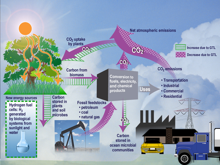
The biospheric and biogeochemical cycles integrate biological processes within the Earth's living sphere—the biosphere—with geochemical and physical transformations across atmospheric, oceanic, lithospheric, and hydrospheric reservoirs, facilitating the recycling of vital elements such as carbon, nitrogen, and phosphorus. These cycles sustain primary production, nutrient availability, and long-term planetary habitability by coupling microbial, plant, and animal activities with abiotic fluxes driven by weathering, sedimentation, and atmospheric transport. In the biosphere, organisms act as dynamic agents: autotrophs fix carbon via photosynthesis, heterotrophs drive decomposition, and microbes mediate redox reactions essential for element transformations, creating feedbacks that stabilize or destabilize system states under varying environmental conditions.[77] The carbon cycle exemplifies biospheric dominance in short-term fluxes, with gross primary productivity—predominantly photosynthetic carbon fixation—reaching approximately 250 GtC per year across terrestrial vegetation and marine phytoplankton, of which marine contributions account for 100–150 GtC per year; elevated atmospheric CO₂ has enhanced this via fertilization effects, increasing global photosynthesis by ~13-15% since the 1980s, improving plant water use efficiency through partial stomatal closure, and driving observed greening trends with 25-50% increases in vegetated areas, ~70% attributable to CO₂. Net primary productivity, after autotrophic respiration, yields around 105 GtC per year globally, supporting biomass accumulation and food webs while respiration and decay release comparable amounts back to the atmosphere as CO₂. Oceanic biological pump sequesters ~10 GtC per year into deep waters via sinking organic matter, linking surface biospheric activity to millennial-scale storage in sediments. These fluxes interact with physical processes like ocean circulation and terrestrial hydrology, but biospheric perturbations, such as shifts in vegetation cover, can amplify or dampen atmospheric CO₂ levels through altered photosynthesis-respiration balances, with CO₂-driven growth contributing to carbon sequestration and regulatory feedbacks via expanded vegetation influencing evapotranspiration and albedo.[78][79][80][81] The nitrogen cycle hinges on biospheric transformations, where microbial nitrogen fixation—primarily by symbiotic bacteria in soils and free-living diazotrophs in oceans—supplies ~140 Tg N per year to ecosystems, enabling protein synthesis and growth limited by this element in many biomes. Nitrification oxidizes ammonium to nitrate for plant uptake, while denitrification reduces nitrate to N₂, releasing 108–160 Tg N per year to the atmosphere, closing the cycle but potentially generating N₂O, a greenhouse gas. Biospheric hotspots, such as legume-root symbioses and ocean upwelling zones, concentrate these fluxes, with turnover times in soils and biomass ranging from years to decades, contrasting slower geological inputs from rock weathering (~10–20 Tg N per year). Imbalances arise from redox gradients influenced by organic matter decomposition, underscoring microbial mediation as a control on bioavailability.[82][83] The phosphorus cycle, more geologically constrained, relies on biospheric uptake for rapid intra-ecosystem recycling, with terrestrial plants and microbes assimilating ~1–3 Tg P per year from soil pools derived from parent rock weathering fluxes of ~15–20 Tg P per year globally. Unlike nitrogen, phosphorus lacks a significant gaseous phase, limiting long-range transport to dust and riverine delivery (~10 Tg P per year to oceans), where marine phytoplankton incorporate it at Redfield ratios (C:N:P ≈ 106:16:1) before sedimentation buries ~5–10 Tg P per year in sediments. Biospheric processes, including mycorrhizal associations enhancing root uptake and microbial solubilization via organic acids, accelerate turnover in fertile soils (months to years), but overall cycle sluggishness—driven by apatite mineral stability—makes phosphorus a limiting nutrient, with biosphere-lithosphere feedbacks dictating long-term fertility. These elemental cycles interlink via stoichiometric constraints, where nitrogen or phosphorus shortages curtail carbon fixation, propagating effects through trophic levels and influencing Earth system resilience.[84][85][86]Lithospheric, Cryospheric, and Solid Earth Processes
The lithosphere, consisting of Earth's rigid crust and uppermost mantle, undergoes primary processes driven by plate tectonics and mantle convection. These include divergence at mid-ocean ridges, where new oceanic crust forms via seafloor spreading at rates typically ranging from 2 to 10 cm per year; convergence at subduction zones, where oceanic plates sink into the mantle, recycling crust and generating volcanic arcs; and lateral motion along transform faults, facilitating earthquakes. Continental collisions, such as those forming the Himalayas around 50 million years ago, result in orogenic uplift that exposes deep crustal rocks and influences long-term carbon sequestration through enhanced silicate weathering.[87][88] Lithospheric thinning or dripping instabilities can lead to gravitational foundering of dense material, as observed in regions like the Andes, altering surface topography and magmatism over millions of years.[89] Solid Earth processes extend to the planet's interior dynamics, including mantle convection cells that transfer heat from the core-mantle boundary to the surface, powering tectonic motions with convective velocities on the order of centimeters per year. Partial melting in the upper mantle produces magma that erupts as volcanism, releasing gases like CO2 and SO2 that modulate atmospheric composition— for instance, large igneous provinces such as the Siberian Traps around 252 million years ago contributed to mass extinctions via greenhouse forcing. Seismic waves from earthquakes, often along plate boundaries, reveal internal structure, with global seismicity rates averaging about 1.4 million events per year, most below magnitude 3. Deformation processes, including isostatic adjustment following surface loading, link solid Earth responses to external forcings like glacial retreat.[90][91] The cryosphere encompasses frozen components such as Antarctic and Greenland ice sheets (holding over 99% of Earth's freshwater ice), glaciers, sea ice, snow cover, and permafrost, which collectively influence albedo, ocean salinity, and global energy balance. Key processes include accumulation from snowfall, ablation via surface melting and sublimation, iceberg calving, and basal sliding under ice streams, with mass loss rates for Greenland exceeding 250 gigatons per year in recent decades based on satellite gravimetry. Permafrost thaw releases stored organic carbon, potentially amplifying greenhouse emissions through microbial decomposition, while sea ice formation rejects brine that drives ocean convection.[92][93] These dynamics exhibit feedbacks, such as reduced albedo from summer melt accelerating further warming. Interactions among these realms and other Earth systems are causal and multifaceted: glacial erosion by cryospheric advance scours lithosphere, depositing sediments that modulate riverine carbon transport to oceans; tectonic uplift elevates cryospheric features, enhancing precipitation in monsoon regimes as seen with the Tibetan Plateau's role in Asian hydrology. Volcanic outgassing perturbs atmospheric chemistry, while isostatic rebound from cryospheric unloading—up to 1 cm per year in Scandinavia post-Last Glacial Maximum—alters sea level and coastal morphology. In Earth system models, these slow processes provide boundary conditions for faster atmospheric and oceanic cycles, though empirical data from seismic and geodetic networks underscore that model representations of lithospheric viscosity and cryospheric rheology often rely on parameterized assumptions with uncertainties in deep mantle properties.[17][94][9]Human Influences and Interactions
Anthropogenic Drivers of Change
Anthropogenic drivers encompass human activities that perturb Earth system components, including the atmosphere, biosphere, hydrosphere, and lithosphere, primarily through industrialization, agriculture, and urbanization. These influences have intensified since the 1950s, coinciding with rapid population growth and economic expansion, leading to measurable shifts in global biogeochemical cycles, radiative forcing, and ecosystem structure. Empirical observations indicate that fossil fuel combustion, land conversion, and industrial processes dominate these changes, with quantifiable effects such as elevated greenhouse gas concentrations and altered surface reflectivity.[95][96] Greenhouse gas emissions represent the most significant radiative forcing driver, with carbon dioxide (CO₂) levels rising from pre-industrial ~280 ppm to 426.06 ppm at Mauna Loa Observatory in October 2025, attributable to combustion of coal, oil, and natural gas. Methane (CH₄) and nitrous oxide (N₂O) emissions, largely from agriculture and waste, have similarly increased, contributing to a total anthropogenic forcing of approximately 2.7 W/m² since 1750. In 2024, global energy-related CO₂ emissions hit a record 37.8 Gt, with the energy sector accounting for 75.7% of total greenhouse gas outputs, followed by agriculture (11.7%) and industry (12.6%). These emissions disrupt atmospheric and oceanic carbon cycles, evidenced by ocean uptake of ~25% of anthropogenic CO₂, resulting in pH declines of 0.1 units since the 1980s.[97][98][99] Land use and cover changes, including deforestation, cropland expansion, and urbanization, have transformed up to 50% of Earth's ice-free land surface, releasing stored carbon and modifying albedo and evapotranspiration. Between 1980 and 2020, net forest loss exceeded 420 million hectares, primarily in tropical regions, elevating atmospheric CO₂ by ~15% of annual fossil fuel contributions and fragmenting habitats that regulate biogeochemical fluxes. Agricultural intensification has intensified soil erosion and nutrient runoff, with global cropland area doubling since 1960, altering hydrological cycles and contributing to ~24% of total anthropogenic methane emissions via rice paddies and livestock. These shifts empirically correlate with reduced primary productivity in affected biomes, as satellite data show declining vegetation greenness in over 20% of global land area since 2000.[100][101][102] Anthropogenic aerosols, emitted from biomass burning, fossil fuel combustion, and industrial processes, exert a net negative radiative forcing of -0.9 W/m², partially offsetting greenhouse gas warming through scattering of solar radiation and cloud brightening. Sulfate aerosols from sulfur dioxide (SO₂) emissions peaked in the late 20th century but declined 20% globally by 2024 due to air quality regulations, unmasking underlying warming and amplifying precipitation extremes in models calibrated to observations. Black carbon deposits on snow and ice reduce surface albedo, accelerating melt rates observed in the Arctic, where deposition has increased by 50% since pre-industrial times. Aerosol effects on ecosystems include altered nutrient deposition, with nitrogen oxides contributing to eutrophication in 30% of European surface waters.[103][104][105] Additional drivers include overexploitation of resources and chemical releases, such as fisheries depleting biomass by 50% since 1950, disrupting marine food webs, and persistent pollutants like chlorofluorocarbons (CFCs) that caused stratospheric ozone depletion peaking in the 1990s before Montreal Protocol reductions. These interact with primary drivers, amplifying systemic feedbacks, though attribution requires distinguishing from natural variability via isotopic and proxy data.[106][107]Feedbacks Between Human Activities and Natural Systems
Human activities, such as fossil fuel combustion and deforestation, introduce perturbations to Earth systems that elicit feedbacks from natural processes, which in turn modulate the magnitude and persistence of these changes. These feedbacks operate through physical, chemical, and biological mechanisms, often amplifying initial anthropogenic forcings in a positive manner while some provide damping in a negative sense. For instance, elevated atmospheric CO2 concentrations from human emissions enhance plant photosynthesis and global greening, potentially increasing terrestrial carbon uptake as a negative feedback estimated at 0.2 to 0.5 GtC per year in recent decades.[61] However, this effect is counteracted by concurrent warming-induced respiration and decomposition, which release stored carbon, resulting in a net positive climate-carbon feedback of approximately 20-200 PgC per degree Celsius of warming across models. In the cryosphere, anthropogenic warming has diminished Arctic sea ice extent by about 13% per decade since 1979, reducing planetary albedo and increasing solar energy absorption, which contributes a positive feedback amplifying regional warming by up to 50% beyond radiative forcing alone.[108] Permafrost thaw, driven by a 2-3°C Arctic temperature rise since pre-industrial times—largely attributable to human influence—liberates methane and CO2 from organic soils, with empirical measurements indicating annual emissions of 30-100 Tg CH4 from thawing sites, potentially adding 0.1-0.2°C to global temperatures by 2100 under moderate emission scenarios.[109] These processes exemplify how initial human-induced changes cascade through coupled subsystems, with observations from satellite data and ground stations confirming accelerated thaw rates exceeding model projections in some regions.[110] Land-use changes, including agriculture and urbanization, alter biogeophysical feedbacks by modifying surface albedo, evapotranspiration, and roughness. Deforestation in tropical regions has decreased latent heat flux by 10-20 W/m² locally, warming surfaces and reducing cloud formation, which sustains drier conditions and further vegetation loss in a positive loop observed in Amazonian drought events of 2005 and 2010.[111] Conversely, aerosol emissions from industrial activities scatter incoming radiation, exerting a negative radiative forcing of -0.5 to -1.0 W/m² globally, though this cooling effect diminishes with air quality improvements, as evidenced by post-2010 reductions in sulfate aerosols correlating with accelerated warming.[108] Ocean systems respond with stratification from surface warming, suppressing nutrient upwelling and primary productivity by 1-2% per decade in subtropical gyres, which curtails biological carbon drawdown and reinforces atmospheric CO2 accumulation.[61] These feedbacks underscore the nonlinearity of Earth system responses, where small anthropogenic inputs can yield disproportionate outcomes due to tipping elements like Amazon dieback or Greenland ice melt, with paleoclimate analogs indicating potential for multi-century commitments. Empirical attribution studies, integrating satellite observations and proxy records, quantify human contributions to feedback activation at over 90% confidence for key processes like water vapor increase, which alone accounts for 50% of the total positive feedback strength in the climate system.[108] Uncertainties persist in cloud feedbacks, with low-altitude cloud reductions observed via CERES satellite data potentially adding 0.5-1.0 W/m² forcing, though inter-model spread highlights the need for continued observational validation over projections.[112]Scientific Debates and Controversies
Limitations and Uncertainties in Models
Earth system models rely on parameterizations to represent sub-grid scale processes, such as turbulence and convection, which cannot be explicitly resolved due to computational constraints, thereby introducing structural uncertainties that propagate through simulations.[113] These approximations often lead to systematic biases, as evidenced by discrepancies in simulating small-scale cloud dynamics, where grid resolutions of 5–100 km fail to capture ephemeral cloud formations critical to energy balance.[114] Cloud feedbacks constitute a dominant source of uncertainty in equilibrium climate sensitivity (ECS), with models exhibiting a wide range of responses to warming; for instance, alterations in low-level cloud cover can amplify or dampen projected temperature increases, but empirical validation remains limited by sparse satellite observations spanning only the past 40 years.[114] Similarly, aerosol-cloud interactions, including indirect effects on cloud droplet number and lifetime, account for the largest uncertainties in historical radiative forcing estimates, complicating attribution of observed trends.[115] In CMIP6 ensembles, approximately 18% of models (10 out of 55) predict ECS values exceeding 5°C, far above the IPCC's assessed range of 2.6–3.9°C derived from paleoclimate and instrumental records, leading to averaged projections that overestimate global warming by up to 0.7°C by 2100 under high-emission scenarios.[116] Validation against observations reveals persistent challenges, particularly in reproducing regional trends; for example, CMIP6 models predominantly simulate eastern tropical Pacific sea surface temperature warming since the mid-20th century, whereas satellite and reanalysis data indicate cooling, with only 1 out of 495 ensemble members aligning with this pattern.[59] Precipitation trends also show partial mismatches, as models capture intensification of the hydrological cycle (e.g., wet regions getting wetter) but underestimate magnitudes in areas like the tropical Pacific Walker circulation.[59] These discrepancies arise from uncertainties in internal variability, forcing agents like volcanic aerosols, and observational errors, underscoring the need for robust, like-for-like comparisons to distinguish model errors from natural fluctuations.[59] Additional limitations stem from model tuning to historical data, which can mask underlying flaws and hinder out-of-sample predictions, as well as incomplete representation of feedbacks like permafrost thaw or ice sheet dynamics due to insufficient resolution and process understanding.[117] In geoengineering contexts, gaps in simulating stratospheric aerosol microphysics—such as nucleation and sedimentation—exacerbate uncertainties in intervention efficacy, with post-eruption analyses (e.g., Mount Pinatubo) highlighting model-observation mismatches.[118] Overall, while ensembles quantify parametric uncertainties, structural deficits and empirical validation hurdles limit confidence in long-term projections, prompting recommendations to prioritize observationally constrained models over unweighted averages.[116][59]Debates on Attribution and Causality
In earth system science, attribution involves detecting observed changes in the climate system and ascribing them to specific forcings, such as anthropogenic greenhouse gases, aerosols, or natural factors like solar irradiance and volcanic activity, while causality debates center on establishing directional influences amid complex interactions.[47] Challenges arise from the nonlinearity of earth systems, where internal variability—such as oscillations in the Pacific Decadal Oscillation (PDO) or Atlantic Multidecadal Oscillation (AMO)—can mimic or mask forced trends, complicating probabilistic assessments.[119] For instance, global climate models often underrepresent natural variability at decadal to centennial scales, leading to inflated estimates of anthropogenic signal strength in hindcasts of 20th-century temperatures.[119] Critiques of dominant attribution frameworks, like those in IPCC reports, argue that they overemphasize radiative forcing from CO2 while downplaying unresolved natural drivers, such as ocean heat uptake dynamics, cosmic ray influences on cloud formation, and self-regulating mechanisms via hydrological cycles, vegetation feedbacks, and biosphere responses to CO2—including CO2 fertilization driving approximately 70% of observed global greening (a 25-50% increase in vegetated area since the 1980s) and water cycle intensification through enhanced evapotranspiration—which act as modulators of climate variability and counterbalances to radiative forcing.[120][80] These perspectives underscore ongoing debates on the relative primacy of isolated CO2 forcing versus integrated system dynamics in driving observed changes, with peer-reviewed analyses suggesting such biosphere feedbacks could explain portions of recent warming trends without implying unprecedented human dominance.[120] A 2023 review highlighted potential overstatement in linking extreme events to anthropogenic forcing, noting that probabilistic event attribution methods frequently conflate correlation with causation by assuming model-simulated "counterfactual" worlds accurately represent natural baselines, despite evidence of systematic model biases toward warmer projections.[121] Surveys of climate scientists reveal divided views, with only a minority endorsing high-confidence attribution of post-1950 warming primarily to humans when accounting for unmodeled natural forcings, underscoring epistemic uncertainties in causal chains.[122] Causality inference in earth systems further debates the adequacy of Granger-style time-series methods versus structural causal models, as the former risks spurious attributions in non-stationary data prevalent in paleoclimate records or satellite observations.[47] For example, mid-20th-century global cooling amid rising CO2 levels has been attributed by some analyses to aerosol effects or PDO phases rather than a temporary GHG masking, challenging linear causality narratives and highlighting the need for falsifiable hypotheses over consensus-driven interpretations.[120] These debates are amplified by institutional biases in academia, where funding and publication pressures favor anthropogenic-centric explanations, potentially sidelining empirical validations of natural dominance in variability-dominant regimes, as evidenced by discrepancies between modeled and observed tropospheric warming patterns.[119] Ongoing advancements in causal counterfactual theory aim to refine these attributions but remain limited by incomplete earth system representations, emphasizing the provisional nature of current claims.[123]Critiques of Overreliance on Projections
Critics contend that Earth system models, which integrate atmospheric, oceanic, biospheric, and lithospheric processes to generate future projections, exhibit systematic biases that undermine their use as primary guides for policy and understanding. Analyses of historical performance reveal that multimodel ensembles, such as those in the Coupled Model Intercomparison Project (CMIP), have consistently overestimated global surface warming rates compared to observations. For instance, Fyfe et al. (2013) demonstrated that models simulated 2.5 times more warming than observed in the upper ocean and global surface from 1993 to 2012, potentially due to overestimated radiative forcing or excessive climate sensitivity.[124] This discrepancy persists in tropospheric layers, where CMIP5 and CMIP6 models project warming rates exceeding satellite measurements by factors of 1.5 to 3 in the tropics and globally, highlighting unresolved issues in simulating convective processes and lapse rate feedbacks.[125][126] Biogeochemical projections within these models amplify concerns, as simulated carbon cycle feedbacks often predict stronger positive responses—such as accelerated soil respiration and reduced terrestrial sinks—than empirical evidence supports. Unconstrained Earth system models forecast substantial net soil carbon losses under moderate warming scenarios, yet observationally constrained variants indicate stability or modest gains due to nutrient limitations and microbial adaptations not fully captured in simulations.[127] Critics, including those reviewing CMIP6 terrestrial biogeochemistry, note persistent biases in simulating variables like gross primary productivity and nitrogen cycling, where models diverge markedly from satellite-derived fluxes and fail to reproduce decadal variabilities tied to El Niño-Southern Oscillation.[128] Overreliance on these projections risks overstating tipping point probabilities, such as permafrost thaw amplification, while underemphasizing empirical validation against eddy covariance data or paleo-reconstructions that suggest more resilient system responses. The inherent uncertainties in projections, reflected in the multi-decadal spread across ensemble members—equivalent to centuries of natural variability—stem from poorly constrained parameters like equilibrium climate sensitivity (ranging 1.5–4.5°C in IPCC assessments) and cloud-aerosol interactions.[129] High-emission scenarios like RCP8.5, once treated as plausible baselines, now appear implausible given declining coal use and technological trends, yet they dominate impact assessments and drive alarmist framings.[130] This practice, critics argue, prioritizes narrative consistency over causal attribution, sidelining adaptation strategies informed by observed trends (e.g., greening effects offsetting some CO2 fertilization limits) and fostering policies detached from verifiable risks like regional droughts or sea-level variability.[131] Selective weighting of models by hindcast fidelity, rather than equal ensemble averaging, could mitigate these issues, but institutional inertia in bodies like the IPCC perpetuates uncritical dependence on unverified long-range forecasts.Recent Developments and Advances
Innovations in Data and Modeling (2020-2025)
The period from 2020 to 2025 witnessed significant advancements in Earth system modeling through the integration of machine learning (ML) techniques, enabling more efficient parameterization of complex processes and improved forecasting accuracy. Foundation models like Aurora, introduced in 2025, represent a paradigm shift by leveraging large-scale training on diverse Earth observation data to perform versatile forecasting tasks across atmospheric, oceanic, and terrestrial components.[132] Similarly, the FuXi Weather system, operationalized in 2025, employs ML for global weather prediction with cycling data assimilation, incorporating multi-satellite observations to enhance resolution and reliability beyond traditional numerical models.[133] These approaches address longstanding computational bottlenecks in Earth system models (ESMs) by emulating subgrid-scale physics, as demonstrated in applications uncovering hidden patterns in rainfall and ocean dynamics.[134] Innovations in data assimilation further refined model initialization and uncertainty quantification, with NOAA outlining a 2025 strategy for fully coupled, continuous Earth system data assimilation to integrate observations from land, ocean, atmosphere, and cryosphere in real-time.[135] This builds on ECMWF's Earth system data assimilation framework, which combines short-range forecasts with diverse observations to optimize state estimates, particularly for biogeochemical cycles and aerosols.[136] Advances in paleoclimate data assimilation, using offline ensemble Kalman filters, have provided deeper insights into historical variability, aiding validation of ESM projections against proxy records from ice cores and sediments.[137] Coupled with satellite radar altimetry improvements for monitoring cryospheric mass balance and inland water storage, these methods have enhanced spatial and temporal resolution in global datasets.[138] High-resolution modeling frameworks, such as the SHiELD family from NOAA's GFDL, advanced kilometer-scale predictions of mesoscale phenomena like convective systems, extending forecast horizons to 15 days by 2025.[139] Specialized models, including FLaMe-v1.0 for lake methane emissions, incorporated physical-biogeochemical coupling to simulate regional emissions with empirical validation against field data.[140] These developments, supported by model-data fusion techniques reviewed in 2022, emphasize heterogeneous data integration to reduce biases in ESM trends relative to observations.[113] Overall, such innovations prioritize empirical fidelity over simplified assumptions, fostering more robust simulations of Earth system interactions amid increasing data volumes from missions like NASA's Earth System Observatory.[141]Empirical Observations Challenging Prior Assumptions
Satellite observations of the tropical troposphere have consistently shown lower warming rates than those simulated by climate models since 1979, with CMIP6 ensembles exhibiting a pervasive bias toward overestimating temperature increases across multiple atmospheric layers, including the mid- to upper troposphere. This discrepancy persists even after accounting for internal variability and forcing adjustments, suggesting overstatement of climate sensitivity or amplification feedbacks in models. For example, analyses indicate that model-projected warming in the 200-300 hPa layer exceeds observed satellite data by factors of up to two, challenging prior assumptions of robust tropical hot spot amplification driven by greenhouse gas forcing.[125][142][143] Global vegetation monitoring via satellite-derived leaf area index (LAI) reveals a dominant greening trend over 25-50% of vegetated lands from 1982 to 2015, with elevated atmospheric CO2 concentrations responsible for about 70% of this increase through enhanced photosynthesis and water-use efficiency, contrary to expectations that rising CO2 would primarily induce biosphere stress and reduced productivity without significant fertilization benefits. This empirical pattern, observed across tropics and high latitudes, underscores underappreciated positive feedbacks in terrestrial carbon uptake, as models had often emphasized drought and heat limitations over CO2-driven growth enhancements.[144][145] Antarctic sea ice extent displayed a positive trend from 1979 to 2014, culminating in record winter maxima of approximately 20.14 million km² in 2014, defying model predictions of decline under global warming scenarios that assumed symmetric polar responses tied to greenhouse forcing. Most coupled climate models in ensembles like CMIP5 and CMIP6 failed to reproduce this expansion, attributed to inadequate representation of Southern Ocean stratification, wind patterns, and freshwater inputs, thereby exposing limitations in simulating regional cryospheric feedbacks. Although extents declined sharply post-2016, reaching record lows by 2023-2025, the preceding multi-decadal increase highlighted overreliance on hemispheric analogies from Arctic observations.[146][147]Applications and Implications
Forecasting Natural Variability and Risks
Natural variability in the Earth system encompasses oscillations such as the El Niño-Southern Oscillation (ENSO), Pacific Decadal Oscillation (PDO), and Atlantic Multidecadal Oscillation (AMO), which drive fluctuations in temperature, precipitation, and extreme weather on timescales from seasons to decades.[148] These modes arise from internal dynamical processes within the coupled ocean-atmosphere system, independent of external forcings like solar or volcanic activity.[149] Forecasting them requires integrating observational data with dynamical models to predict phase transitions and amplitudes, as these influence global teleconnections affecting agriculture, water resources, and disaster preparedness.[150] Operational forecasts for ENSO, which operates on 2-7 year cycles, achieve skill up to 1-2 seasons ahead using coupled general circulation models initialized with real-time observations from buoys and satellites.[148] For longer modes like PDO (10-30 years) and AMO (50-70 years), prediction skill diminishes due to chaotic internal variability and weaker signal-to-noise ratios, with statistical-dynamical hybrid approaches extending hindcast accuracy to 5-10 years in some cases.[148] Earth system models, such as those in the Community Earth System Model (CESM) Large Ensemble, simulate ensembles of initial-condition variability to quantify uncertainty, revealing that internal fluctuations dominate near-term (decadal) projections over forced trends.[151] Risks from natural variability include amplified extremes, such as ENSO-driven droughts in Australia or floods in South America, where positive AMO phases correlate with increased Atlantic hurricane activity.[152] PDO cool phases have been linked to enhanced Asian monsoon variability, exacerbating regional food security threats.[153] Quantifying these risks involves probabilistic hazard modeling, but challenges persist from model underestimation of variability in the tropics and incomplete representation of sub-grid processes like ocean eddies.[154] Peer-reviewed assessments highlight persistent difficulties in resolving decadal predictability barriers, where ensemble spread from internal variability exceeds forced signals until mid-century, complicating risk attribution.[155] Advances since 2020 include machine learning-augmented initialization techniques improving ENSO forecast lead times by 1-3 months, though validation against independent observations underscores ongoing biases in tropical Pacific simulations.[156] In risk frameworks, natural modes contribute over 70% to uncertainty in metrics like river overflow susceptibility through 2100, necessitating scenario-based ensembles that separate variability from anthropogenic influences for robust planning.[154]Policy-Relevant Insights and Empirical Validation
Empirical assessments of Earth system models reveal persistent discrepancies between simulated and observed trends, particularly in regional patterns such as tropical Pacific sea surface temperatures and Southern Ocean dynamics, where models often overestimate cooling or variability.[157][158] These mismatches underscore the challenges in using unvalidated projections for policy decisions, as they can lead to overstated risks in areas like sea-level rise or extreme weather attribution. For instance, observations indicate larger decreases in high-cloud cover than projected by many models, which influences estimates of radiative forcing and long-term sensitivity.[159] Climate sensitivity, a key parameter for policy-relevant projections of warming under emissions scenarios, shows empirical estimates that are often lower than multimodel means from Earth system simulations. Energy budget analyses derived from satellite and surface observations yield equilibrium climate sensitivity values around 0.54 K per W/m² (approximately 2°C for doubled CO₂), with uncertainties highlighting the limitations of relying on high-sensitivity model ensembles for cost-benefit analyses of mitigation strategies.[160] Such findings suggest that policies emphasizing rapid decarbonization based on upper-bound sensitivities may overlook adaptation to empirically observed, more moderate trends, potentially misallocating resources away from verifiable risks like regional droughts driven by natural oscillations.[161] Natural variability, including phenomena like the Atlantic Multidecadal Variability and Pacific Decadal Variability, contributes substantially to decadal and regional temperature fluctuations, sometimes rivaling anthropogenic forcing in magnitude.[162][163] Empirical decomposition of trends attributes a significant portion of recent fire weather risks or streamflow changes to these internal modes rather than solely greenhouse gases, informing policies to prioritize resilient infrastructure over assumptions of monotonic anthropogenic dominance.[164] This validation emphasizes causal realism in attributing extremes, reducing overconfidence in model-derived tipping point thresholds that lack robust observational support and advocating for scenario planning that integrates variability for more reliable risk management.[165]References
- https://www.earthdata.[nasa](/page/NASA).gov/learn/earth-observation-data-basics