
Community hub
Recent from talks
Contribute something
Nothing was collected or created yet.
Svalbard
View on Wikipedia
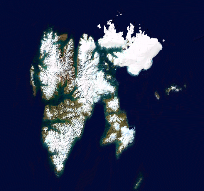
Svalbard (/ˈsvɑːlbɑːr(d)/ SVAHL-bar(d),[4] Urban East Norwegian: [ˈsvɑ̂ːɫbɑr]), previously known as Spitsbergen or Spitzbergen, is a Norwegian archipelago that lies at the convergence of the Arctic Ocean with the Atlantic Ocean. North of mainland Europe, it lies about midway between the northern coast of Norway and the North Pole. The islands of the group range from 74° to 81° north latitude, and from 10° to 35° east longitude. The largest island is Spitsbergen (37,673 km2), followed in size by Nordaustlandet (14,443 km2), Edgeøya (5,073 km2), and Barentsøya (1,288 km2). Bjørnøya or Bear Island (178 km2) is the most southerly island in the territory, situated some 147 km south of Spitsbergen. Other small islands in the group include Hopen to the southeast of Edgeøya, Kongsøya and Svenskøya in the east, and Kvitøya to the northeast. The largest settlement is Longyearbyen, situated in Isfjorden on the west coast of Spitsbergen.[5]
Key Information


Whalers who sailed far north in the 17th and 18th centuries used the islands as a base; subsequently, the archipelago was abandoned.[6][7] Coal mining started at the beginning of the 20th century, and several permanent communities such as Pyramiden and Barentsburg were established.[8] The Svalbard Treaty of 1920 recognizes Norwegian sovereignty, and the Norwegian Svalbard Act of 1925 made Svalbard a full part of the Kingdom of Norway. The Svalbard Treaty established Svalbard as a free economic zone and restricts the military use of the archipelago. The Norwegian Store Norske and the Russian Arktikugol remain the only mining companies in place.
Research and tourism have become important supplementary industries, with the University Centre in Svalbard and the Svalbard Global Seed Vault playing critical roles in the local economy. Apart from Longyearbyen, other settlements include the Russian mining community of Barentsburg, the Norwegian research station of Ny-Ålesund, the Polish research station of Hornsund, the settlement of Nybyen, and the Swedish-Norwegian mining outpost of Sveagruva (which closed in 2020).[9] Other settlements lie farther north, but are populated only by rotating groups of researchers. No roads connect the settlements; instead, snowmobiles, aircraft, and boats provide inter-settlement transport. Svalbard Airport serves as the main gateway.
Approximately 60% of the archipelago is covered with glaciers, and the islands feature many mountains and fjords.[10] The archipelago has an Arctic climate, although with significantly higher temperatures than other areas at the same latitude due to the impact of the tail end of the Gulf Stream from the Atlantic Ocean. The flora has adapted to take advantage of the long period of midnight sun to compensate for the polar night.[11] Many seabirds use Svalbard as a breeding ground, and it is home to polar bears, reindeer, the Arctic fox, and certain marine mammals. Seven national parks and 23 nature reserves cover two-thirds of the archipelago, protecting the largely untouched fragile environment. Norway announced new regulations regarding tourism in February 2024, including a maximum of 200 people on a ship, to protect flora and fauna in Svalbard.[12]
While part of the Kingdom of Norway since 1925, Svalbard is not part of geographical Norway; administratively, the archipelago is not part of any Norwegian county, but forms an unincorporated area.[13] This means that it is administered directly by the Norwegian government through an appointed governor, and is a special jurisdiction subject to the Svalbard Treaty that is outside of the Schengen Area, the Nordic Passport Union, and the European Economic Area. Svalbard and Jan Mayen are collectively assigned the ISO 3166-1 alpha-2 country-code "SJ". Both areas are administered by Norway, though they are separated by a distance of over 950 kilometres (510 nautical miles) and have very different administrative structures.
Etymology
[edit]
The name Svalbard was officially adopted for the archipelago by Norway under the 1925 Svalbard Act which formally annexed it.[14] The former name Spitsbergen was thenceforth restricted to the main island. In 1827, Baltazar Keilhau first proposed that the Old Norse toponym Svalbarði, found in medieval Icelandic sources, referred to Spitsbergen.[14][15] Keilhau's theory was revived by Gustav Storm in 1890 and Gunnar Isachsen in 1907, at a time when ancient Norse connection to the land would help modern Norway's contested claim to sovereignty.[14][15] Svalbard is a modern Norwegian analogue of Svalbarði, which in turn derives from svalr ('cold') and barð ('edge', 'ridge', 'turf', 'beard').[15]
The Icelandic Annals record that Svalbarði was discovered in 1194, while the Landnámabók places it four days' sailing north of Langanes.[15] The word dægr "day" might mean either 12 or 24 hours; Isachsen took the latter interpretation, thus discounting Jan Mayen as Svalbarði.[15] Cultural studies academic Roald Berg says Svalbarði more likely referred to part of Greenland, but the 1925 renaming cemented Norwegian sovereignty as recognised by the 1920 Spitsbergen Treaty (now the Svalbard Treaty).[14]
The name Spitsbergen originated with Dutch navigator and explorer Willem Barentsz, who in 1596 described the "pointed mountains" or, in Dutch, spitse bergen that he saw on the west coast of the main island. Barentsz did not recognize that he had discovered an archipelago, and consequently the name Spitsbergen long remained in use both for the main island and for the archipelago as a whole.[16] Later the main island was sometimes distinguished as West Spitsbergen. The spelling Spitzbergen, with z instead of s, derives from German.[17]
Geography
[edit]
The Svalbard Treaty of 1920[18] defines Svalbard as all islands, islets, and skerries from 74° to 81° north latitude, and from 10° to 35° east longitude.[19][20] The land area is 61,022 km2 (23,561 sq mi), and dominated by the island of Spitsbergen, which constitutes more than half the archipelago, followed by Nordaustlandet and Edgeøya.[21]
All settlements are on Spitsbergen, except the meteorological outposts on Bjørnøya and Hopen.[18] The Norwegian state took possession of all unclaimed land, or 95.2% of the archipelago, at the time the Svalbard Treaty entered into force; Store Norske, a Norwegian coal mining company, owns 4%, Arktikugol, a Russian coal mining company, owns 0.4%, while other private owners hold 0.4%.[22]
As Svalbard is north of the Arctic Circle, it experiences midnight sun in summer and polar night in winter. At 74° north, the midnight sun lasts 99 days and polar night 84 days, while the respective figures at 81° north are 141 and 128 days.[23] In Longyearbyen, midnight sun lasts from 20 April until 23 August, and polar night lasts from 26 October to 15 February.[19] In winter, the combination of full moon and reflective snow can give additional light.[23]
Due to the Earth's tilt and the high latitude, Svalbard has extensive twilights. Longyearbyen sees the first and last day of polar night having seven and a half hours of twilight, whereas the perpetual light lasts for two weeks longer than the midnight sun.[24][25] On the summer solstice, the sun bottoms out at 12° sun angle in the middle of the night, being much higher during night than in mainland Norway's polar light areas.[26] However, the daytime maximum sun angle at the summer solstice is approximately 35°.
Glacial ice covers 36,502 km2 (14,094 sq mi) or 60% of Svalbard; 30% is barren rock while 10% is vegetated.[27] The largest glacier is Austfonna (8,412 km2 or 3,248 sq mi) on Nordaustlandet, followed by Olav V Land and Vestfonna. During summer, it is possible to ski from Sørkapp in the south to the north of Spitsbergen, with only a short distance not being covered by snow or glacier. Kvitøya is 99.3% covered by glacier.[28]
The landforms of Svalbard were created through repeated ice ages, when glaciers cut the former plateau into fjords, valleys, and mountains.[29] The tallest peak is Newtontoppen (1,717 m or 5,633 ft), followed by Perriertoppen (1,712 m or 5,617 ft), Ceresfjellet (1,675 m or 5,495 ft), Chadwickryggen (1,640 m or 5,380 ft), and Galileotoppen (1,637 m or 5,371 ft). The longest fjord is Wijdefjorden (108 km or 67 mi), followed by Isfjorden (107 km or 66 mi), Van Mijenfjorden (83 km or 52 mi), Woodfjorden (64 km or 40 mi), and Wahlenbergfjorden (46 km or 29 mi).[30] Svalbard is part of the High Arctic Large Igneous Province,[31] and experienced Norway's strongest earthquake on 6 March 2009 at magnitude 6.5.[32]
History
[edit]Dutch discovery
[edit]

The Dutchman Willem Barentsz made the first discovery of the archipelago in 1596, when he sighted the coast of the island of Spitsbergen while searching for the Northern Sea Route.[33]
The first recorded landing on the islands of Svalbard dates to 1604, when an English ship landed at Bjørnøya, or Bear Island, and started hunting walrus. Annual expeditions soon followed, and Spitsbergen became a base for hunting the bowhead whale from 1611.[34][35] Because of the lawless nature of the area, English, Danish, Dutch, and French companies and authorities tried to use force to keep out other countries' fleets.[36][37]
17th–18th centuries
[edit]
Smeerenburg was one of the first settlements, established by the Dutch in 1619.[38] Smaller bases were also built by the English, Danish, and French. At first, the outposts were merely summer camps, but from the early 1630s, a few individuals started to overwinter. Whaling at Spitsbergen lasted until the 1820s, when the Dutch, British, and Danish whalers moved elsewhere in the Arctic.[39] By the late 17th century, Russian hunters arrived; they overwintered to a greater extent and hunted land mammals such as the polar bear and fox.[40]
Norwegian hunting—mostly for walrus—started in the 1790s. The first Norwegian citizens to reach Spitsbergen proper were a number of Coast Sámi people from the Hammerfest region, who were hired as part of a Russian crew for an expedition in 1795.[41]
19th century
[edit]After the Anglo-Russian War in 1809, Russian activity on Svalbard diminished, and had ceased by the 1820s.[42] Norwegian whaling was abandoned about the same time as the Russians left,[43] but whaling continued around Spitsbergen until the 1830s, and around Bjørnøya until the 1860s.[44]
20th century
[edit]Svalbard Treaty
[edit]By the 1890s, Svalbard had become a destination for Arctic tourism, coal deposits had been found, and the islands were being used as a base for Arctic exploration.[45] The first mining was along Isfjorden by Norwegians in 1899; by 1904, British interests had established themselves in Adventfjorden and started the first year-round operations.[46] Production in Longyearbyen, by US interests, started in 1908;[47] and Store Norske established itself in 1916, as did other Norwegian interests during the First World War, in part by buying US interests.[48]
.svg)
Discussions to establish the sovereignty of the archipelago commenced in the 1910s,[50] but were interrupted by World War I.[51] On 9 February 1920, following the Paris Peace Conference, the Svalbard Treaty was signed, granting full sovereignty to Norway. However, all signatory countries were granted non-discriminatory rights to fishing, hunting, and mineral resources.[52] The treaty took effect on 14 August 1925, at the same time as the Svalbard Act regulated the archipelago and the first governor, Johannes Gerckens Bassøe, took office.[53]
The archipelago has traditionally been known as Spitsbergen, and the main island as West Spitsbergen. During the 1920s, Norway renamed the archipelago Svalbard, and the main island became Spitsbergen.[54] Kvitøya, Kong Karls Land, Hopen, and Bjørnøya were not regarded as part of the Spitsbergen archipelago.[55] Russians have traditionally called the archipelago Grumant (Грумант).[56] The Soviet Union retained the name Spitsbergen (Шпицберген) to support undocumented claims that Russians were the first to discover the island.[57][58]
In 1928, Italian explorer Umberto Nobile and the crew of the airship Italia crashed on the icepack off the coast of Foyn Island. The subsequent rescue attempts were covered extensively in the press and Svalbard received short-lived fame as a result.[59]
Second World War
[edit].jpg)
Svalbard, known to both British and Germans as Spitsbergen, was little affected by the German invasion of Norway in April 1940. The settlements continued to operate as before, mining coal and monitoring the weather.[60][61][62]
In July 1941, following the German invasion of the Soviet Union, the Royal Navy reconnoitered the islands with a view to using them as a base of operations to send supplies to north Russia, but the idea was rejected as impractical.[63] Instead, with the agreement of the Soviets and the Norwegian government in exile, in August 1941 the Norwegian and Soviet settlements on Svalbard were evacuated, and facilities there destroyed, in Operation Gauntlet.[64][65] However, the Norwegian government in exile decided it would be important politically to establish a garrison in the islands, which was done in May 1942 during Operation Fritham.[66]
Meanwhile, the Germans responded to the destruction of the weather station by establishing a reporting station of their own, codenamed "Banso", in October 1941.[67] They were chased away in October by a visit from what the Germans mistook to be four British warships, but later returned.[68] A second station, "Knospe", was established at Ny-Ålesund in 1941, remaining until 1942. In May 1942, after the arrival of the Fritham force, the German unit at Banso was evacuated.[69]
In September 1943 in Operation Zitronella a German task force, which included the battleship Tirpitz, was sent to attack the garrison and destroy the settlements at Longyearbyen and Barentsburg.[70] This was achieved, but had little long-term effect: after their departure the Norwegians returned and re-established their presence.[71]
In September 1944, the Germans set up their last weather station, Operation Haudegen in Nordaustlandet; it functioned until after the German surrender.[72] On 4 September 1945, the soldiers were picked up by a Norwegian seal hunting vessel and surrendered to its captain. This group of men were the last German troops to surrender after the Second World War.[73]
After the war, the Soviet Union proposed common Norwegian and Soviet administration and military defence of Svalbard. This was rejected in 1947 by Norway, which two years later joined NATO. The Soviet Union retained high civilian activity on Svalbard, in part to ensure that the archipelago was not used by NATO.[74]
Post-war
[edit]
After the war, Norway re-established operations at Longyearbyen and Ny-Ålesund,[75] while the Soviet Union established mining in Barentsburg, Pyramiden, and Grumant.[76] The mine at Ny-Ålesund had several fatal accidents, killing 71 people while it was in operation from 1945 to 1954 and from 1960 to 1963. The Kings Bay Affair, caused by the 1962 accident killing 21 workers, forced Gerhardsen's Third Cabinet to resign.[77][78]
From 1964, Ny-Ålesund became a research outpost, and a facility for the European Space Research Organisation.[79] Petroleum test drilling was started in 1963 and continued until 1984, but no commercially viable fields were found.[80] From 1960, regular charter flights were made from the mainland to a field at Hotellneset;[81] in 1975, Svalbard Airport, Longyearbyen opened, allowing year-round services.[82]
During the Cold War, the Soviet Union supplied about two-thirds of the population on the islands (Norwegians making up the remaining third) with the population of the archipelago slightly under 4,000.[76] Russian activity has diminished considerably since then, falling from 2,500 to 450 people from 1990 to 2010.[83][84] Grumant was closed after it was depleted in 1962.[76]
Pyramiden was closed in 1998.[85] Coal exports from Barentsburg ceased in 2006 because of a fire,[86] but resumed in 2010.[87] The Russians experienced two air accidents: Vnukovo Airlines Flight 2801 (1996), which killed 141 people,[88] and the Heerodden helicopter accident (2008), which killed three people.[89]
Longyearbyen remained purely a company town until 1989 when utilities, culture, and education was separated into Svalbard Samfunnsdrift.[90] In 1993, it was sold to the national government and the University Centre was established.[91] Through the 1990s, tourism increased and the town developed an economy independent of Store Norske and mining.[92] Longyearbyen was incorporated on 1 January 2002, adopting a community council.[90]
On 30 June 2025 the Mine 7, the last Norwegian coal mine in Svalbard, was closed, though the mine in Barentsburg continued operation.[93]
Population
[edit]Demographics
[edit]

In 2016, Svalbard had a population of 2,667, of which 423 were Russian and Ukrainian, 10 Polish, and 322 other non-Norwegians living in Norwegian settlements.[21] The largest non-Norwegian groups in Longyearbyen in 2005 were from Russia, Ukraine, Poland, Germany, Sweden, Denmark, and Thailand.[84]
In mid-2023, there were 3,094 inhabitants on Spitsbergen, including 2,465 at Longyearbyen, 130 at Ny-Ålesund, and 10 (Polish) at the Hornsund (Isbjørnhamna) research station; there were 440 Russians at Barentsburg and some 50 at Pyramiden. There were no inhabitants on the other islands except for nine at the meteorological station on Bear Island (at Herwighamna) and four at the one on Hopen.[citation needed]
As of January 2025, there were 1691 Norwegians and 865 non-Norwegians living in Longyearbyen and Ny-Ålesund;[94] there were 297 residents of Barentsburg and Pyramiden; and there were 10 residents of Hornsund.[95]
Settlements
[edit]Longyearbyen is the largest settlement on the archipelago; it is the seat of the governor and the only incorporated town. The town features an airport, hospital, primary and secondary school, university, sports center with a swimming pool, library, culture center, cinema,[86] bus transport, hotels, a bank,[96] and several museums.[97] The newspaper Svalbardposten is published weekly.[98] Very little mining activity remains at Longyearbyen; coal mines at Sveagruva and Lunckefjellet suspended operations in 2017 and were closed permanently in 2020.[99][100]

Ny-Ålesund is a permanent research settlement in the northwest of Spitsbergen and the northernmost functional civilian settlement in the world. Formerly a mining town, it is still a company town operated by the Norwegian state-owned Kings Bay company. While some tourism to the outpost is permitted, Norwegian authorities limit access to minimize impact on scientific work.[86] Ny-Ålesund has a winter population of 35 and a summer population of 180.[101] The Norwegian Meteorological Institute has outposts at Bjørnøya and Hopen, with nine and four inhabitants respectively. Both can also house temporary research staff.[86] Poland operates the Polish Polar Station at Hornsund, with ten permanent residents.[86]

The Russian (formerly Soviet) mining settlement of Pyramiden was abandoned in 1998, leaving Barentsburg as the only permanently inhabited Russian settlement. It is a company town: all facilities are owned by Arktikugol, which operates a coal mine. In addition to the mining facilities, Arktikugol has opened a hotel and souvenir shop, catering to tourists taking day trips or hikes from Longyearbyen.[86]
The village features a school, library, sports center, community center, swimming pool, farm, and greenhouse. Pyramiden features similar facilities; both are built in typical post-World War II Soviet architectural and planning style and contain the world's two most northerly Lenin statues and other socialist realist art.[102] As of 2023[update], about 48 workers are stationed in the largely abandoned Pyramiden to maintain local infrastructure and run its hotel, which has been re-opened to tourism.[103][104]
Religion
[edit]Most of the population is Christian. Most of the Norwegians are affiliated with the Church of Norway. Russian and Ukrainian population belongs to the Orthodox Church. Catholics on the archipelago are pastorally served by the Territorial Prelature of Tromsø.[105]
Politics
[edit]
The Svalbard Treaty of 1920 established full Norwegian sovereignty over the archipelago. The islands are, unlike the Norwegian Antarctic territories, a part of the Kingdom of Norway and not a dependency. The treaty came into effect in 1925, following the Svalbard Act. All forty-eight signatory countries of the treaty have the right to conduct commercial activities on the archipelago without discrimination, although all activity is subject to Norwegian legislation. The treaty limits Norway's right to collect taxes to that of financing services on Svalbard.[20][106] Therefore, Svalbard has a lower income tax than mainland Norway, and there is no value added tax. There is a separate budget for Svalbard to ensure compliance.[107]
Svalbard is not governed by Norway's policies on migration and does not issue visas or residence permits itself.[108][109] Foreigners do not need a visa or work and residence permits from the Norwegian authorities to travel to Svalbard. However, foreign citizens with a visa requirement for the Schengen Area must have a Schengen visa when travelling to and from Svalbard via mainland Norway.[110]
The Svalbard Act established the institution of the Governor of Svalbard (Norwegian: Sysselmester, formerly Sysselmannen), who holds the responsibility as both county governor and chief of police, as well as holding other authority granted from the executive branch. Duties include environmental policy, family law, law enforcement, search and rescue, tourism management, information services, contact with foreign settlements, and judge in some areas of maritime inquiries and judicial examinations—albeit never in the same cases as acting as police.[111][112] Since 2021, Lars Fause has been governor. The institution is subordinate to the Ministry of Justice and the Police, but reports to other ministries in matters within their portfolio.[113]

Since 2002, Longyearbyen Community Council has had many of the same responsibilities of a municipality, including utilities, education, cultural facilities, fire department, roads, and ports.[92] No care or nursing services are available, nor are welfare payments available. Norwegian residents retain pension and medical rights through their mainland municipalities.[114] The hospital is part of University Hospital of North Norway, while the airport is operated by state-owned Avinor. Ny-Ålesund and Barentsburg remain company towns with all infrastructure owned by Kings Bay and Arktikugol.[92] Other public offices with presence on Svalbard are the Norwegian Directorate of Mining, the Norwegian Polar Institute, the Norwegian Tax Administration, and the Church of Norway.[115] Svalbard is subordinate to Nord-Troms District Court and Hålogaland Court of Appeal, both in Tromsø.[116]
Although Norway is part of the European Economic Area (EEA) and the Schengen Agreement, Svalbard is not part of the Schengen Area or the EEA.[117] Non-EU and non-Nordic Svalbard residents do not need Schengen visas for Svalbard itself, but those travelling via mainland Norway require visas to pass through Norway. People without a source of income can be rejected by the governor.[118]
No one is required to have a visa or residence permit on Svalbard. Regardless of citizenship, persons can live and work in Svalbard indefinitely. The Svalbard Treaty grants treaty nationals equal right of abode as Norwegian nationals. So far, non-treaty nationals have been admitted visa-free as well. While there is no visa requirement, everyone must meet certain requirements in order to stay in Svalbard. These requirements are governed by a separate policy called "Regulations relating to rejection and expulsion of persons from Svalbard".[119] Among the requirements is that residents must have the means to be able to reside on Svalbard. These requirements apply to both foreigners and Norwegian citizens, and the Governor of Svalbard may reject persons who do not meet the requirements.[110][clarification needed][120][121] Russia retains a consulate in Barentsburg.[122]
In September 2010, a treaty was signed between Russia and Norway fixing the boundary between the Svalbard archipelago and the Novaya Zemlya archipelago. Increased interest in petroleum exploration in the Arctic raised interest in a resolution of the dispute. The agreement takes into account the relative positions of the archipelagos, rather than being based simply on northward extension of the continental border of Norway and Russia.[123]
Defense
[edit]Svalbard constitutes a demilitarized zone, as the treaty prohibits the establishment of military installations on the islands. However, since the treaty recognizes Norway as the sovereign power in the archipelago, the country claims exclusive rights in the maritime zone around the islands; rights which Norway argues permit the Norwegian Coast Guard to conduct fishery and other maritime surveillance and enforcement in these waters.[20][106][124] Certain other parties to the treaty (including Spain, Iceland and particularly Russia) argue that the Treaty provides them with extensive rights beyond Svalbard's territorial sea.[125] Norway claims an exclusive economic zone of more than three-quarters of a million square kilometers around Svalbard, though "Russia does not recognize Norwegian functional rights with respect to the Svalbard Fisheries Protection Area".[126]
In the 2020s, in order to strengthen Norway's ability to enforce its claims around the archipelago, the Norwegian Coast Guard embarked on a significant modernization program. As of 2023, the Coast Guard is replacing its older Nordkapp-class offshore patrol vessels with significantly larger ice-capable ships, each displacing just under 10,000 tonnes. The three new Jan Mayen-class offshore patrol vessels are armed with a 57 mm (2.2 in) main gun and are capable of operating up to two medium-sized helicopters. The ships have a maximum speed of 22 knots (41 km/h; 25 mph) with more than 60 days endurance and the complement is up to 100 people.[127] The first ship, KV Jan Mayen, was delivered in early 2023.[128] These vessels will complement NoCGV Svalbard which predominantly serves Svalbard and the surrounding waters. In 2023, Norway also announced the acquisition of six MH-60R helicopters which are to be initially deployed with the Coast Guard, though they are to be prepared to be equipped for anti-submarine operations as well.[129] The Royal Norwegian Navy patrols waters of the Svalbard Archipelago at least once a year with a Fridtjof Nansen-class frigate.[130]
The Royal Norwegian Air Force fleet of Boeing P-8 Poseidons stationed at Evenes Air Station on the mainland have capacity for surveillance of the Svalbard Archipelago as part of the surveillance of the Barents Sea.[131][132] The F-35s of the Royal Norwegian Air Force stationed at Evenes Air Station has range to patrol over parts of the Svalbard Archipelago, and could also be stationed further north at Banak Air Station if deemed necessary.[citation needed]
With the 2022 Russian invasion of Ukraine, tensions in the Arctic have increased. In January 2022, an undersea telecommunications cable connecting Svalbard with mainland Norway was damaged. Norwegian suspicions fell on a Russian trawler as the only vessel in the area at the time. The investigation was nevertheless reported as inconclusive. In 2022, Russia announced new investment plans to support its presence at Barentsburg and Pyramiden.[133]
Economy
[edit]
The three main industries on Svalbard are coal mining, tourism, and research. In 2007, there were 484 people working in the mining sector, 211 people working in the tourism sector, and 111 people working in the education sector. The same year, the mining yielded revenues of 2.008 billion Norwegian kroner (US$227,791,078), tourism 317 million kroner (US$35,967,202), and research 142 million kroner (US$16,098,404).[92][134]
In 2006, the average income for economically active people was 494,700 kroner, 23% higher than on the mainland.[135] Almost all housing is owned by the various employers and institutions and rented to their employees; there are only a few privately owned houses, most of which are recreational cabins. Because of this, it is difficult to live on Svalbard without working for an established institution.[118]
Since the resettlement of Svalbard in the early 20th century, coal mining has been the dominant commercial activity. Store Norske Spitsbergen Kulkompani, a subsidiary of the Norwegian Ministry of Trade and Industry, operates Svea Nord in Sveagruva and Mine 7 in Longyearbyen. The former produced 20 million tonnes from the period 2001–2009, while the latter uses 35% of its output to fuel the Longyearbyen Power Station.[136] In March 2020, the Sveagruva mining settlement was shut down due to budget related issues and efforts to clean up after coal mining in Svalbard.[137]
Since 2007, there has not been any significant mining by the Russian state-owned Arktikugol in Barentsburg.[92] The Gruve 7 mine shut down in June 2025.[93][138]
There has been test drilling for petroleum on land, but these did not give satisfactory results for permanent operation. Norwegian authorities do not allow offshore petroleum activities for environmental reasons, and the land formerly test-drilled have been protected as natural reserves or national parks.[92] In 2011, a 20-year plan to develop offshore oil and gas resources around Svalbard was announced.[139]
Svalbard has historically been a base for both whaling and fishing. Norway claimed a 200-nautical-mile (370-kilometre) exclusive economic zone (EEZ) around Svalbard in 1977,[22] with 31,688 square kilometres (9,239 square nautical miles) of internal waters and 770,565 square kilometres (224,661 square nautical miles) of EEZ.[140] Norway retains a restrictive fisheries policy in the zone,[22] and the claims are disputed by Russia.[18]
Tourism is focused on the environment and is centered on Longyearbyen. Activities include hiking, kayaking, walks through glacier caves, and snowmobile and dog-sled safaris. Cruise ships generate a significant portion of the traffic, including both stops by offshore vessels and expeditionary cruises starting and ending in Svalbard. Traffic is strongly concentrated between March and August; overnight stays have quintupled from 1991 to 2008, when there were 93,000 overnight stays.[92]
In February 2024, Norway announced limits on tourism to favor protection of flora and fauna in the archipelago. Now, ships are limited to 200 passengers in protected areas, among other regulations, many of which concern the breaking of fast ice, use of vehicles on sea ice after 1 March, and marine traffic near walrus areas. There are 43 defined landing spots.[12]
The Arctic World Archive, a huge digital archiving concern run by Norwegian private company Piql and the state-owned coal-mining company Store Norske Spitsbergen Kulkompani, opened in March 2017.[141] In mid-2020, it acquired its biggest customer in the form of GitHub, a subsidiary of Microsoft.[142]
One source of income for the area was, until 2015, visiting cruise ships. The Norwegian government became concerned about large numbers of cruise ship passengers suddenly landing at small settlements such as Ny-Ålesund, which is conveniently close to the barren-yet-picturesque Magdalena Fjord. With the increasing size of the larger ships, up to 2,000 people can potentially appear in a community that normally numbers less than 40. As a result, the government severely restricted the size of cruise ships that may visit.[143]
Unemployment is effectively nonexistent as there is no public assistance.[109]
Science and research
[edit]_5.jpg)
Research on Svalbard centers on Longyearbyen and Ny-Ålesund, the most accessible areas in the high Arctic. The Svalbard Treaty grants permission for any nation to conduct non-military research on Svalbard, resulting in the Polish Polar Station and the Chinese Arctic Yellow River Station, plus Russian facilities in Barentsburg.[144] Concerns have been raised about potential dual use of the Arctic Yellow River Station.[145][146]
The University Centre in Svalbard in Longyearbyen offers undergraduate, graduate, and postgraduate courses to 350 students in various arctic sciences, particularly biology, geology, and geophysics. Courses are provided to supplement studies at mainland universities; there are no tuition fees and courses are held in English, with Norwegian and international students equally represented.[91]
The Svalbard Global Seed Vault is a seedbank to store seeds from as many of the world's crop varieties and their botanical wild relatives as possible. A cooperation between the government of Norway and the Global Crop Diversity Trust, the vault is cut into rock near Longyearbyen, keeping it at a natural −6 °C (21 °F) and refrigerating the seeds to −18 °C (0 °F).[147][148]
The Svalbard Undersea Cable System is a 1,440 km (890 mi) fibre optic line from Svalbard to Harstad, needed for communicating with polar orbiting satellites through Svalbard Satellite Station and installations in Ny-Ålesund.[149][150]
Transport
[edit]
In Longyearbyen, Barentsburg, and Ny-Ålesund, there are road networks, but they do not connect with each other. Off-road motorized transport is prohibited on bare ground in Svalbard, but snowmobiles are used extensively during winter—both for commercial and recreational activities. Transport from Longyearbyen to Barentsburg (45 km or 28 mi) and Pyramiden (100 km or 62 mi) is possible by snowmobile in winter, or by ship all year round. All settlements have ports and Longyearbyen has a bus system.[151]
Svalbard Airport, 3 kilometres (2 mi) from Longyearbyen, is the only airport offering air transport off the archipelago. Scandinavian Airlines has daily scheduled services to Tromsø and Oslo. Low-cost carrier Norwegian Air Shuttle also has a service between Oslo and Svalbard, operating three or four times a week; there are also irregular charter services to Russia.[152] Finnair operated service from Helsinki, operating three times per week between June and August 2016, but Norwegian authorities disallowed this route, citing the 1978 bilateral agreement on air traffic between Finland and Norway.[153][154][155]
Lufttransport provides regular corporate charter services from Longyearbyen to Ny-Ålesund Airport, Hamnerabben, and Svea Airport for Kings Bay and Store Norske. These flights are generally not available to the public.[156] There are heliports in Barentsburg and Pyramiden, and helicopters are frequently used by the governor and to a lesser extent the mining company Arktikugol.[157]
Climate
[edit]
The climate of Svalbard is dominated by its high latitude, with the average daily mean summer temperature at 4 to 7 °C (39 to 45 °F) (1991–2020 averages), and January averages at −13 to −9 °C (9 to 16 °F) (1991–2020). The more southern Bear Island has January mean temperatures as mild as −4.6 °C (24 °F) in the 1991–2020 base period.[158]
The West Spitsbergen Current, the northernmost branch of the North Atlantic Current system, moderates Svalbard's temperatures, particularly during winter. Winter temperatures in Svalbard are up to 20 °C (36 °F) higher than those at similar latitudes in Russia and Canada. The warm Atlantic water keeps the surrounding waters open and navigable most of the year. The interior fjord areas and valleys, sheltered by the mountains, have larger temperature differences than the coast, giving about 2 °C (4 °F) warmer summer temperatures and 3 °C (5 °F) colder winter temperatures.[159]
On the south of Spitsbergen, the temperature is slightly higher than further north and west. During winter, the temperature difference between south and north is typically 5 °C (9 °F), and about 3 °C (5 °F) in summer. Bear Island has average temperatures even higher than the rest of the archipelago.[159]
Svalbard is where cold polar air from the north and mild, wet sea air from the south meet, creating low pressure, changeable weather and strong winds, particularly in winter; in January, a strong breeze is registered 17% of the time at Isfjord Radio, but only 1% of the time in July. In summer, fog is common, particularly off the coast, with visibility under 1 kilometre (0.6 mi) registered 20% of the time in July and 1% of the time in January, at Hopen and Bjørnøya.[160]
Precipitation is frequent, but falls in small quantities, typically less than 400 millimetres (16 in) per year in western Spitsbergen. More rain falls on the uninhabited east side, where there can be more than 1,000 millimetres (39 in).[160] On average, Svalbard has lower humidity than other places in the Arctic Circle. The only places in the Arctic with a lower average are in mainland Norway, Sweden and Finland.[citation needed]
2016 was the warmest year on record at Svalbard Airport, with a remarkable mean temperature of 0.0 °C (32.0 °F), 7.5 °C (13.5 °F) above the 1961–90 average, and more comparable to a location at the Arctic Circle. The coldest temperature of the year was as high as −18 °C (0 °F), warmer than the mean minimum in a normal January, February or March. In the same year, the number of days when there was rainfall equalled the number of days when there was snowfall, a significant deviation from the usual pattern whereby there would be at least twice as many snow days.[161]
Global warming has resulted in noticeable climatic changes on Svalbard. Between 1970 and 2020, the average temperature on Svalbard rose by 4 degrees Celsius, and in the winter months by 7 degrees.[162] On 25 July 2020, a new record temperature of 21.7 °C (71.1 °F) was measured for the Svalbard archipelago, which is also the highest temperature ever recorded in the European part of the High Arctic; in addition, temperatures of over 20 degrees were measured four days in a row in July 2020.[163]
As in large parts of the Arctic, the ice–albedo feedback effects can also be noticed on Svalbard: Due to the substantial ice melt, ice surfaces are transformed into open water, the darker surface of which absorbs more solar energy instead of reflecting it back; as a result, these waters heat up and further ice in the area melts faster and faster, creating more open waters, etc. A temperature increase of between 7 and 10 degrees is expected on Svalbard by the end of the century.[162]
Nature
[edit]_26.jpg)
In addition to humans, three primarily terrestrial mammalian species inhabit the archipelago: the Arctic fox, the Svalbard reindeer, and accidentally introduced southern voles, which are found only in Grumant.[164] Attempts to introduce the Arctic hare and the muskox have both failed.[165] There are 15 to 20 types of marine mammals, including: whales, dolphins, seals, walruses, and polar bears.[164]
Polar bears are the iconic symbol of Svalbard, and one of the main tourist attractions.[166] The animals are protected and people moving outside the settlements are required to have appropriate scare devices to ward off attacks. They are also advised to carry a firearm for use as a last resort.[167][168] In August 2011, a British schoolboy was killed and four others were injured by a polar bear.[169] In July 2018, a polar bear was shot dead after it attacked and injured a polar bear guard leading tourists off a cruise ship.[170][171] In August 2020, a Dutch man was killed by a polar bear at a campsite in Longyearbyen. The polar bear was shot dead.[172][173] In 2022, a polar bear attacked a French tourist, who suffered injuries to an arm. The bear left after shots had been fired. It was later euthanised following a professional assessment of its injuries.[174]
As of 2021, Svalbard has around 300 resident[175] polar bears.[176] Svalbard and Franz Joseph Land share a common population of roughly 2,650 polar bears, with Kong Karls Land being the most important breeding ground.[177]
_with_cub,_Svalbard.jpg)
The Svalbard reindeer (R. tarandus platyrhynchus) is a distinct subspecies; although it was previously almost extinct, it can be legally hunted (as can Arctic fox).[164] It has also been documented that polar bears, desperate for food, hunt and successfully kill Svalbard reindeer.[178] There are limited numbers of domesticated animals in the Russian settlements.[179]
About eighty species of bird are found on Svalbard, most of which are migratory.[180] The Barents Sea is among the areas in the world with most seabirds, with about 20 million individuals during late summer. The most common are: little auk, northern fulmar, thick-billed murre, and black-legged kittiwake. Sixteen species are on the IUCN Red List. Particularly Bjørnøya, Storfjorden, Nordvest-Spitsbergen, and Hopen are important breeding ground for seabirds. The Arctic tern has the furthest migration, all the way to Antarctica.[164]
Two songbirds migrate to Svalbard to breed: the snow bunting and the northern wheatear. Rock ptarmigan is the only bird to overwinter.[181] Remains of Predator X (Pliosaurus funkei) from the Jurassic period were discovered here. It is one of the largest dinosaur-era marine reptiles ever found.[182]

Svalbard has permafrost and tundra, including low, middle, and high Arctic vegetation. One hundred and sixty-five species of plants have been found on the archipelago.[164] Only those areas which defrost in the summer are vegetated, which accounts for about 10% of the archipelago.[183] Vegetation is most abundant in Nordenskiöld Land, around Isfjorden and where affected by guano.[184] While there is little precipitation, giving the archipelago a steppe climate, plants still have good access to water because the cold climate reduces evaporation.[160][164] The growing season is very short, and may last only a few weeks.[185] The Svalbard poppy (Papaver dahlianum) is the symbolic flower of Svalbard.[186]

There are seven national parks in Svalbard: Forlandet, Indre Wijdefjorden, Nordenskiöld Land, Nordre Isfjorden Land, Nordvest-Spitsbergen, Sassen-Bünsow Land and Sør-Spitsbergen.[187] The archipelago has fifteen bird sanctuaries, one geotopic protected area and six nature reserves—with Nordaust-Svalbard and Søraust-Svalbard both being larger than any of the national parks. Most of the nature reserves and three of the national parks were created in 1973, with the remaining areas gaining protection in the 2000s.[188] All human traces dating from before 1946 are automatically protected.[167] The protected areas make up 65% of the archipelago.[135] Svalbard is on Norway's tentative list for nomination as a UNESCO World Heritage Site.[189]
The total solar eclipse of 20 March 2015 included only Svalbard and the Faroe Islands in the band of totality.[190]
Education
[edit]Longyearbyen School serves ages 6–18. It is the primary/secondary school in the northernmost location on Earth. Once pupils reach ages 16 or 17, most families move to mainland Norway.[191] Barentsburg has its own school serving the Russian community; by 2014 it had three teachers, and its welfare funds had declined.[192] A primary school served the community of Pyramiden in the pre-1998 period.[193]
There is a non-degree offering tertiary educational institution in Longyearbyen,[191] University Centre in Svalbard (UNIS), the northernmost tertiary school on Earth.[194]
-

-
 Barentsburg School
 -


Sports
[edit]Association football is the most popular sport in Svalbard. There are three football pitches (one at Barentsburg), but no stadiums because of the small population.[195] There is also an indoor hall adopted for multiple sports including indoor football.[196] Winter sports, such as skiing, snowmobiling and dog sledding, are popular.[197] There is a multi-sport club, Svalbard Turn.[197]
See also
[edit]References
[edit]Notes
[edit]Citations
[edit]- ^ "World Factbook: Svalbard". www.cia.gov. Archived from the original on 13 January 2021. Retrieved 17 April 2019.
- ^ "Svalbard". Central Intelligence Agency. 15 February 2023. Retrieved 16 March 2023 – via CIA.gov.
- ^ "Population of Svalbard". Statistics Norway. Archived from the original on 7 August 2020. Retrieved 4 July 2020. Table 2: Population in the settlements. Svalbard
- ^ "Svalbard – definition of Svalbard in English | Oxford Dictionaries". Oxford Dictionaries | English. Archived from the original on 18 September 2016. Retrieved 17 September 2016.
- ^ Dickie, Gloria (1 June 2021). "The World's Northernmost Town Is Changing Dramatically". Scientific American. 324 (6): 44–53. doi:10.1038/scientificamerican0621-44. PMID 39020622. Archived from the original (Original title: "The Polar Crucible") on 18 May 2021. Retrieved 20 May 2021.
- ^ "Whaling – Svalbard Museum". svalbardmuseum.no. Retrieved 13 May 2024.
- ^ Norum, Roger; Proctor, James (3 May 2018). Svalbard: Spitsbergen, Jan Mayen and Franz Josef Land. Bradt Travel Guides. pp. 29–30, 43. ISBN 978-1-78477-047-1.
- ^ Norum, Roger; Proctor, James (3 May 2018). Svalbard: Spitsbergen, Jan Mayen and Franz Josef Land. Bradt Travel Guides. p. 60. ISBN 978-1-78477-047-1.
- ^ Stange, Rolf (26 February 2020). "Svea Nord is history". Spitsbergen | Svalbard. Retrieved 19 May 2024.
- ^ Godone, Danilo (4 October 2017). Glacier Evolution in a Changing World. BoD – Books on Demand. pp. 11–12. ISBN 978-953-51-3543-2.
- ^ "Svalbard: Svalbard". ncpor.res.in. Retrieved 15 May 2024.
- ^ a b "Norway: Amendments to environmental regulations in Svalbard". ieu-monitoring.com. Insight EU Monitoring. Archived from the original on 5 May 2025. Retrieved 5 May 2025.
The Norwegian Government has adopted several amendments to the environmental regulations in Svalbard. 'Climate change together with increased activity has resulted in a great pressure on the vulnerable arctic wildlife and nature in Svalbard. We are now tightening the environmental regulations in Svalbard to strengthen the protection of flora and fauna, says the Norwegian minister of climate and environment,' Mr. Andreas Bjelland Eriksen.
- ^ Svalbard, Norway. Svalbard, Norway – historical views – earth watching. (n.d.). European Space Agency
- ^ a b c d Berg, Roald (December 2013). "From "Spitsbergen" to "Svalbard". Norwegianization in Norway and in the "Norwegian Sea", 1820–1925". Acta Borealia. 30 (2): 154–173. doi:10.1080/08003831.2013.843322. S2CID 145567480.
- ^ a b c d e Isachsen, Gunnar (June 1907). "La découverte du Spitsberg par les Normands". La Géographie. 15 (6): 421–432.
- ^ In Search of Het Behouden Huys: A Survey of the Remains of the House of Willem Barentsz on Novaya Zemlya, LOUWRENS HACQUEBORD, p. 250 Archived 27 March 2009 at the Wayback Machine.
- ^ ... the Archipelago of Spitsbergen, comprising, with Bear Island... all the islands situated between 10deg. and 35deg. longitude East of Greenwich and between 74deg. and 81 deg. latitude North, especially West Spitsbergen..." Treaty concerning the Archipelago of Spitsbergen (1920), p. 1.
- ^ a b c "Svalbard". World Fact Book. Central Intelligence Agency. 15 January 2010. Archived from the original on 13 January 2021. Retrieved 24 March 2010.
- ^ a b "Svalbard". Norwegian Polar Institute. Archived from the original on 15 April 2012. Retrieved 24 March 2010.
- ^ a b c "Svalbard Treaty". Wikisource. 9 February 1920. Archived from the original on 24 March 2010. Retrieved 24 March 2010.
- ^ a b "Population in the settlements. Svalbard". Statistics Norway. 22 October 2009. Retrieved 24 March 2010.[dead link]
- ^ a b c "7 Industrial, mining and commercial activities". Report No. 9 to the Storting (1999–2000): Svalbard. Norwegian Ministry of Justice and the Police. 29 October 1999. Archived from the original on 11 October 2012. Retrieved 24 March 2010.
- ^ a b Torkilsen (1984): 96–97
- ^ "Sunrise and sunset in Longyearbyen October 2019". Timeanddate.com. Archived from the original on 29 October 2019. Retrieved 29 October 2019.
- ^ "Sunrise and sunset in Longyearbyen April 2019". Timeanddate.com. Archived from the original on 13 December 2019. Retrieved 29 October 2019.
- ^ "Sunrise and sunset in Longyearbyen June". Timeanddate.com. Archived from the original on 29 October 2019. Retrieved 29 October 2019.
- ^ Umbreit (2005): 3
- ^ Torkildsen (1984): 102–104
- ^ Umbreit (2005): 4–6
- ^ "Geographical survey. Fjords and mountains". Statistics Norway. 22 October 2009. Archived from the original on 14 November 2011. Retrieved 24 March 2010.
- ^ Maher, Harmon D. Jr. (November 1999). "Research Project on the manifestation of the High Arctic Large Igneous Province (HALIP) on Svalbard". University of Nebraska at Omaha. Archived from the original on 28 June 2010. Retrieved 24 March 2010.
- ^ "Svalbard hit by major earthquake". The Norway Post. Norwegian Broadcasting Corporation. 7 March 2009. Archived from the original on 14 March 2012. Retrieved 24 March 2010.
- ^ Torkildsen (1984): 30. Arlov (1996): 39–40
- ^ Torkildsen (1984): 32
- ^ Arlov (1996): 62
- ^ Torkildsen (1984): 34–36
- ^ Arlov (1996): 63–67
- ^ Torkildsen (1984): 37
- ^ Torkildsen (1984): 39
- ^ Torkildsen (1984): 40
- ^ Carlheim-Gyllensköld (1900), p. 155
- ^ Torkildsen (1984): 44
- ^ Torkildsen (1984): 47
- ^ Torkildsen (1984): 50
- ^ Arlov (1996): 239
- ^ Arlov (1996): 249
- ^ Arlov (1996): 261
- ^ Arlov (1996): 273
- ^ Jan Oskar Engene (7 February 1996). "Svalbard flag proposal (Norway)". Flags of the World. Retrieved 31 January 2023.
- ^ Arlov (1996): 288
- ^ Arlov (1996): 294
- ^ Arlov (1996): 305–306
- ^ Arlov (1996): 319
- ^ Umbreit (2005): XI–XII
- ^ "Place names of Svalbard". Norwegian Polar Institute. Archived from the original on 6 June 2011. Retrieved 24 March 2010.
- ^ Arlov (1996): 51
- ^ Fløgstad (2007): 18
- ^ Arlov (1996): 50
- ^ Cross (2002): 84–85; 128–130
- ^ Dege (2004): 289–296
- ^ "World War II: The Weather War". Svalbard Museum. Retrieved 26 March 2024.
- ^ "World War II – Svalbard Museum". svalbardmuseum.no. Retrieved 10 May 2024.
- ^ Roskill Vol I: 388
- ^ Arlov (1996): 397
- ^ Roskill Vol I: 389
- ^ Roskill Vol II: 132–133
- ^ Arlov (1996): 400
- ^ Dege (2004): XI
- ^ Dege (2004): XI-XIII
- ^ Arlov (1996): 402–403
- ^ Roskill Vol III: 62
- ^ Selinger, Franz (1 April 1986). "Forsvarsmuseet's Svalbard expeditions 1984 and 1985". GeoJournal. 12 (3): 337–340. doi:10.1007/BF00175022. ISSN 1572-9893.
- ^ Dege (2004): 258
- ^ Arlov (1996): 407–408
- ^ Torkildsen (1984): 206
- ^ a b c Torkildsen (1984): 202
- ^ "Kings Bay" (in Norwegian). Archived from the original on 3 November 2006. Retrieved 24 March 2010.
- ^ "Kings Bay-saken" (in Norwegian). Archived from the original on 9 November 2006. Retrieved 24 March 2010.
- ^ Arlov (1996): 412
- ^ Torkildsen (1984): 261
- ^ Tjomsland and Wilsberg (1995): 163
- ^ Tjomsland and Wilsberg (1995): 162–164
- ^ "Persons in settlements 1 January. 1990–2005". Statistics Norway. Archived from the original on 14 November 2011. Retrieved 24 March 2010.
- ^ a b "Non-Norwegian population in Longyearbyen, by nationality. Per 1 January. 2004 and 2005. Number of persons". Statistics Norway. Archived from the original on 23 May 2010. Retrieved 24 March 2010.
- ^ Fløgstad (2007): 127
- ^ a b c d e f "10 Longyearbyen og øvrige lokalsamfunn". St.meld. nr. 22 (2008–2009): Svalbard. Norwegian Ministry of Justice and the Police. 17 April 2009. Archived from the original on 11 October 2012. Retrieved 24 March 2010.
- ^ Staalesen, Atle (8 November 2010). "Russians restarted coal mining at Svalbard". Barents Observer. Archived from the original on 20 November 2010. Retrieved 26 January 2010.
- ^ "29 Aug 1996". Aviation Safety Network. Archived from the original on 17 April 2010. Retrieved 24 March 2010.
- ^ Eisenträger, Stian & Per Øyvind Fange (30 March 2008). "- Kraftig vindkast trolig årsaken". Verdens Gang. Archived from the original on 10 June 2011. Retrieved 24 March 2010.
- ^ a b Arlov and Holm (2001): 49
- ^ a b "Arctic science for global challenges". University Centre in Svalbard. Archived from the original on 6 February 2012. Retrieved 24 March 2010.
- ^ a b c d e f g "9 Næringsvirksomhet". St.meld. nr. 22 (2008–2009): Svalbard. Norwegian Ministry of Justice and the Police. 17 April 2009. Archived from the original on 25 August 2011. Retrieved 24 March 2010.
- ^ a b "The Looming Military Threat in the Arctic". The Economist. 12 August 2025. Retrieved 12 August 2025.
- ^ Hansen, Pål (21 June 2025). "Norsk tilstedeværelse på Svalbard svekkes: Lokalstyret ber regjeringen gripe inn". NRK (in Norwegian Bokmål). Retrieved 31 July 2025.
- ^ "Population of Svalbard". SSB. Retrieved 31 July 2025.
- ^ "Shops/services". Svalbard Reiseliv. Archived from the original on 12 April 2010. Retrieved 24 March 2010.
- ^ "Attractions". Svalbard Reiseliv. Archived from the original on 25 January 2010. Retrieved 24 March 2010.
- ^ Umbreit (2005): 179
- ^ Stange, Rolf (15 February 2019). "Lunckefjellet: the end of an arctic coal mine". Spitsbergen | Svalbard. Archived from the original on 29 November 2020. Retrieved 28 January 2020.
- ^ Stange, Rolf (26 February 2020). "Svea Nord is history". Spitsbergen | Svalbard. Archived from the original on 5 December 2020. Retrieved 19 October 2020.
- ^ "Ny-Ålesund". Kings Bay. Archived from the original on 10 March 2009. Retrieved 24 March 2010.
- ^ Umbreit (2005): 94–203
- ^ "Back in Pyramiden, Svalbard – RUIN MEMORIES". 18 June 2013. Archived from the original on 18 June 2013. Retrieved 24 June 2024.
- ^ Barr, Susan (14 February 2020), "Pyramiden", Store norske leksikon (in Norwegian), retrieved 24 June 2024
- ^ "Catholic Church in Svalbard and Jan Mayen". www.gcatholic.org. Archived from the original on 5 September 2019. Retrieved 5 September 2019.
- ^ a b "Svalbard Treaty". Governor of Svalbard. Archived from the original on 23 July 2011. Retrieved 24 March 2010.
- ^ "The Svalbard Treaty – Svalbard Museum". svalbardmuseum.no. Retrieved 24 June 2024.
- ^ "Visas and immigration". Governor of Svalbard. Archived from the original on 14 December 2019. Retrieved 21 November 2019.
- ^ a b Higgins, Andrew (9 July 2014). "A Harsh Climate Calls for Banishment of the Needy". The New York Times. ISSN 0362-4331. Archived from the original on 13 December 2019. Retrieved 21 November 2019.
- ^ a b "Entry and residence". Governor of Svalbard. Archived from the original on 9 May 2021. Retrieved 1 June 2021.
- ^ "5 The administration of Svalbard". Report No. 9 to the Storting (1999–2000): Svalbard. Norwegian Ministry of Justice and the Police. 29 October 1999. Archived from the original on 18 July 2012. Retrieved 24 March 2010.
- ^ "Lov om Svalbard" (in Norwegian). Lovdata. 19 June 2009. Archived from the original on 9 March 2014. Retrieved 24 March 2010.
- ^ "Organisation". Governor of Svalbard. Archived from the original on 23 July 2011. Retrieved 24 March 2010.
- ^ "From the cradle, but not to the grave" (PDF). Statistics Norway. Archived from the original (PDF) on 15 May 2016. Retrieved 24 March 2010.
- ^ "6 Administrasjon". St.meld. nr. 22 (2008–2009): Svalbard. Norwegian Ministry of Justice and the Police. 17 April 2009. Archived from the original on 11 October 2012. Retrieved 24 March 2010.
- ^ "Nord-Troms tingrett". Norwegian National Courts Administration. Archived from the original on 25 August 2011. Retrieved 24 March 2010.
- ^ "Lov om gjennomføring i norsk rett av hoveddelen i avtale om Det europeiske økonomiske samarbeidsområde (EØS) m.v. (EØS-loven)". Lovdata (in Norwegian). 10 August 2007. Archived from the original on 10 December 2000. Retrieved 24 March 2010.
- ^ a b "Entry and residence". Governor of Svalbard. Archived from the original on 24 September 2015. Retrieved 24 August 2015.
- ^ "Forskrift om bortvisning og utvisning av personer fra Svalbard – Lovdata".
- ^ "Entry and residence". sysselmannen.no. Archived from the original on 24 September 2015. Retrieved 24 August 2015.
- ^ "Immigrants warmly welcomed". aljazeera.com. Archived from the original on 3 August 2017.
- ^ "Diplomatic and consular missions of Russia". Ministry of Foreign Affairs of Russia. Archived from the original on 2 October 2009. Retrieved 24 March 2010.
- ^ "Russia and Norway Agree on Boundary" Archived 11 December 2016 at the Wayback Machine article by Andrew E. Kramer in The New York Times 15 September 2010. Retrieved 16 September 2010
- ^ Wither, James (8 September 2021). "Svalbard: NATO's Arctic 'Achilles' Heel'". Per Concordiam. Retrieved 16 August 2023.
- ^ Pedersen, Torbjørn (November 2008). "The constrained politics of the Svalbard offshore area". Marine Policy. 32 (6): 913–919. Bibcode:2008MarPo..32..913P. doi:10.1016/j.marpol.2008.01.006. Retrieved 17 August 2023.
- ^ "KYSTVAKTEN – NORWEGIAN COAST GUARD". Research Gate. January 2019. Retrieved 19 August 2023.
- ^ "Norway's New Coast Guard Vessel Arrives for Fitting Out at Vard".
- ^ "Norway's Newest Coast Guard Vessel Ready for Operations in the High North". High North News. 23 June 2023.
- ^ Felstead, Peter (15 March 2023). "Norway to Replace its Cancelled NH90s with Six Sikorsky MH-60Rs". European Security and Defence. Retrieved 5 June 2023.
- ^ Nilsen, Thomas (15 November 2021). "Russia complains of Norwegian navy's visit to Svalbard". Arctic Today. Retrieved 22 August 2023.
- ^ "Evenes". Forsvaret (in Norwegian Nynorsk). Retrieved 1 July 2024.
- ^ Nilsen, Thomas (17 May 2022). "How Norway's new P-8 Poseidon will counter Russia's submarine threat in Arctic waters". ArcticToday. Retrieved 1 July 2024.
- ^ Rosen, Kenneth (17 December 2022). "A Battle for the Arctic Is Underway. And the U.S. Is Already Behind". Politico. Retrieved 18 August 2023.
- ^ "Currency Converter – MSN Money". www.msn.com. Archived from the original on 27 January 2016. Retrieved 19 January 2016.
- ^ a b "Focus on Svalbard". Statistics Norway. Archived from the original on 13 November 2011. Retrieved 24 March 2010.
- ^ Norwegian Ministry of Justice and the Police (2008–2009). Report No. 22 to the Storting: Svalbard (PDF) (Report). Norwegian Ministry of Justice and the Police. p. 85; 111. Archived from the original (PDF) on 19 June 2024. Retrieved 19 June 2024.
- ^ "Svea-gruva på Svalbard stengt etter 100 år" [The Svea mine on Svalbard closed after 100 years]. itromso.no (in Norwegian). 4 March 2020. Archived from the original on 28 June 2021. Retrieved 21 March 2022.
- ^ "Norway's last Arctic miners are struggling with coal mine's end". ABC News. Australian Broadcasting Corporation. AP. 13 February 2023. Retrieved 12 February 2023.
- ^ Gibbs, Walter; Koranyi, Balazs (18 November 2011). "Norway mobilises for oil push into Arctic". Reuters. Archived from the original on 2 December 2011. Retrieved 20 November 2011.
- ^ "Oversikt over geografiske forhold". Statistics Norway. 2009. Archived from the original on 1 September 2010. Retrieved 24 March 2010.
- ^ Vincent, James (4 April 2017). "Keep your data safe from the apocalypse in an Arctic mineshaft". The Verge. Archived from the original on 22 December 2019. Retrieved 13 August 2020.
- ^ Linder, Courtney (15 November 2019). "Github Code – Storing Code for the Apocalypse". Popular Mechanics. Archived from the original on 16 March 2021. Retrieved 13 August 2020.
- ^ Machan, Teresa (17 March 2014). "Cruise regulations put Svalbard off-limits". The Daily Telegraph. Archived from the original on 11 January 2022. Retrieved 6 April 2018.
- ^ "8 Research and higher education". Report No. 9 to the Storting (1999–2000): Svalbard. Norwegian Ministry of Justice and the Police. 29 October 1999. Archived from the original on 23 January 2010. Retrieved 24 March 2010.
- ^ Tatlow, Didi Kirsten (21 July 2024). "China's expanding Arctic ambitions challenge the U.S. and NATO". Newsweek. Retrieved 21 July 2024.
- ^ Tang, Jane (7 November 2024). "How Chinese nationalism is sending jitters through the Arctic". Radio Free Asia. Retrieved 10 November 2024.
- ^ Hopkin, M. (15 February 2007). "Norway Reveals Design of Doomsday' Seed Vault". Nature. 445 (7129): 693. doi:10.1038/445693a. PMID 17301757.
- ^ "Life in the cold store". BBC News. 26 February 2008. Archived from the original on 19 October 2009. Retrieved 24 March 2010.
- ^ Gjesteland, Eirik (2004). "Technical solution and implementation of the Svalbard fibre cable" (PDF). Telektronic (3). Archived from the original (PDF) on 10 April 2008. Retrieved 24 March 2010.
- ^ Skår, Rolf (2004). "Why and how Svalbard got the fibre" (PDF). Telektronic (3). Archived from the original (PDF) on 10 April 2008. Retrieved 24 March 2010.
- ^ Umbreit (1997): 63–67
- ^ "Direkteruter" (in Norwegian). Avinor. Archived from the original on 2 March 2009. Retrieved 9 September 2009.
- ^ "Finnair opens twelve new scheduled routes and increases frequencies for summer 2016". Finnair. Archived from the original on 8 December 2015. Retrieved 2 December 2015.
- ^ "Finnair denied route to Longyearbyen". thebarentsobserver.com. Archived from the original on 4 August 2016.
- ^ "Finnair grounded: Norway refuses to allow direct flights between Helsinki and Svalbard, citing 1978 agreement – icepeople". icepeople.net. Archived from the original on 17 October 2016.
- ^ "Charterflygning" (in Norwegian). Lufttransport. Archived from the original on 19 July 2011. Retrieved 9 September 2009.
- ^ "11 Sjø og luft – transport, sikkerhet, redning og beredskap". St.meld. nr. 22 (2008–2009): Svalbard. Norwegian Ministry of Justice and the Police. 17 April 2009. Archived from the original on 11 October 2012. Retrieved 24 March 2010.
- ^ "Temperaturnormaler for Spitsbergen i perioden 1961–1990" (in Norwegian). Norwegian Meteorological Institute. Archived from the original on 17 July 2012. Retrieved 24 March 2010.
- ^ a b Torkilsen (1984): 98–99
- ^ a b c Torkilsen (1984): 101
- ^ S.L., Tutiempo Network. "Climate Svalbard Lufthavn (Year 2016) – Climate data (10080)". tutiempo.net. Archived from the original on 8 January 2017.
- ^ a b Hanssen-Bauer, I.; Førland, E.J.; Hisdal, H.; Mayer, S.; Sandø, A.B.; Sorteberg, A. (2019). "Climate in Svalbard 2100: A knowledge base for climate adaptation" (PDF). Norwegian Environment Agency. ISSN 2387-3027. Archived (PDF) from the original on 5 September 2019. Retrieved 27 August 2021.
- ^ "Highest-ever temperature recorded in Norwegian Arctic archipelago". CTV News. 26 July 2020. Archived from the original on 9 October 2021. Retrieved 27 August 2021.
- ^ a b c d e f "Protected Areas in Svalbard" (in Norwegian). Norwegian Directorate for Nature Management. Archived from the original on 27 September 2011. Retrieved 24 March 2010.
- ^ Umbreit (2005): 33
- ^ Torkildsen (1984): 174
- ^ a b Umbreit (2005): 132
- ^ "Firearms in Svalbard". Sysselmannen.no. Archived from the original on 16 July 2016. Retrieved 30 June 2016.
- ^ "Polar bear kills British boy in Arctic". BBC News. 5 August 2011. Archived from the original on 23 February 2012.
- ^ Grieshaber, Kristen (28 July 2018). "Polar Bear Killed After Attack on Arctic Cruise Ship Guard". NBC4 Washington. Archived from the original on 24 March 2019. Retrieved 24 March 2019.
- ^ "German man attacked by polar bear on Norwegian island | DW | 28 July 2018". DW.COM. Archived from the original on 24 March 2019. Retrieved 24 March 2019.
- ^ "Nederlander gedood door ijsbeer op Spitsbergen" [Dutchman killed by polar bear on Spitsbergen]. nos.nl (in Dutch). 28 August 2020. Retrieved 28 August 2020.
- ^ "Polar bear kills Dutch man in Norway's Arctic Svalbard archipelago". Reuters. 28 August 2020. Archived from the original on 28 August 2020. Retrieved 28 August 2020.
- ^ "Polar bear killed after injuring woman at Svalbard campsite". The Guardian. Associated Press. 8 August 2022. Retrieved 11 August 2022.
- ^ Inge Johansen, Jørn; Eriksen, Inghild (1 July 2021). "På Svalbard er det cirka 300 "fastboende" isbjørner". NPK (in Norwegian). Archived from the original on 1 July 2021. Retrieved 1 July 2021.
- ^ Aars, Jon; Marques, Tiago A.; Lone, Karen; Andersen, Magnus; Wiig, Øystein; Fløystad, Ida Marie Bardalen; Hagen, Snorre B.; Buckland, Stephen T. (2017). "The number and distribution of polar bears in the western Barents Sea". Polar Research. 36. doi:10.1080/17518369.2017.1374125. hdl:10852/65137. ISSN 1751-8369.
- ^ Obbard, Martyn E.; Thiemann, Gregory W.; Peacock, Elizabeth; DeBruyn, Terry D. (2010). Polar bears: proceedings of the 15th Working Meeting of the IUCN/SSC Polar Bear Specialist Group, Copenhagen, Denmark, 29 June-3 July 2009 (PDF). Gland, Switzerland and Cambridge, UK: IUCN. p. 150; 159. ISBN 978-2-8317-1255-0.
- ^ Stempniewicz, Lech; Kulaszewicz, Izabela; Aars, Jon (2021). "Yes, they can: polar bears Ursus maritimus successfully hunt Svalbard reindeer Rangifer tarandus platyrhynchus". Polar Biology. 44 (11): 2199–2206. Bibcode:2021PoBio..44.2199S. doi:10.1007/s00300-021-02954-w. ISSN 1432-2056.
- ^ Torkildsen (1984): 165
- ^ "eBird – Svalbard". eBird. Archived from the original on 20 November 2008. Retrieved 22 September 2019.
- ^ Torkilsen (1984): 162
- ^ "Enormous Jurassic Sea Predator, Pliosaur, Discovered in Norway". Science Daily. 29 February 2008. Archived from the original on 23 May 2010. Retrieved 24 March 2010.
- ^ Torkilsen (1984): 144
- ^ Umbreit (2005): 29–30
- ^ Umbreit (2005): 32
- ^ About Svalbard: Flora Archived 6 July 2019 at the Wayback Machine, Sysselmannen.no, retrieved: 10 April 2018
- ^ "Norges nasjonalparker" (in Norwegian). Norwegian Directorate for Nature Management. Archived from the original on 14 September 2010. Retrieved 24 March 2010.
- ^ "Verneområder i Svalbard sortert på kommuner" (in Norwegian). Norwegian Directorate for Nature Management. Archived from the original on 24 August 2011. Retrieved 24 March 2010.
- ^ "Svalbard". UNESCO. Archived from the original on 30 January 2012. Retrieved 24 March 2010.
- ^ "Solar eclipse: Faroe Islands and Svalbard see the sun vanish – video". The Guardian. 20 March 2015. Retrieved 22 June 2023.
- ^ a b "Learning in the freezer". The Guardian. 29 August 2007. Archived from the original on 29 October 2017. Retrieved 29 October 2017.
- ^ Skinner, Toby (1 May 2014). "The Russians on Svalbard". Norwegian Air Shuttle (inflight magazine). Archived from the original on 29 October 2017. Retrieved 29 October 2017.
- ^ Umbreit (2005)
- ^ "Heidi The glaciologist". Norwegian Air Shuttle (inflight magazine). 1 May 2014. Archived from the original on 29 October 2017. Retrieved 29 October 2017.
- ^ "Tony's Non-League Forum: All Other Football Interests: All other football: Is this the world's most Northerly Football Ground?". nonleaguematters.co.uk. Archived from the original on 27 July 2017.
- ^ "Fotball på Svalbard". Archived from the original on 24 December 2019. Retrieved 24 November 2019.
- ^ a b "Svalbard's sporting frontier: from ice to the pitch". All Things Nordic. 7 January 2024. Retrieved 5 April 2024.
Sources
[edit]- Arlov, Thor B. (1996). Svalbards historie: 1596–1996 (in Norwegian). Oslo: Aschehoug. ISBN 82-03-22171-8. Retrieved 22 May 2021.
- Arlov, Thor B.; Holm, Arne O.; Moe, Kirsti (2001). Fra company town til folkestyre: samfunnsbygging i Longyearbyen på 78° nord (in Norwegian). Longyearbyen: Svalbard samfunnsdrift. ISBN 82-996168-0-8. Retrieved 22 May 2021.
- Carlheim-Gyllensköld, V. (1900). På åttionda breddgraden. En bok om den svensk-ryska gradmätningen på Spetsbergen; den förberedande expeitionen sommaren 1898, dess färd rundt spetsbergens kuster, äfventyr i båtar och på isen; ryssars och skandinavers forna färder; m.m., m.m. Stockholm: Albert Bonniers förlag.
- Chisholm, Hugh, ed. (1911). . Encyclopædia Britannica. Vol. 25 (11th ed.). Cambridge University Press. pp. 708–711.
- Cross, Wilbur (2002). Disaster at the Pole: The Crash of the Airship Italia (1st ed.). Lyons Press. ISBN 9781585744961.
- Dege, Wilhelm (2004). Barr, William (ed.). War North of 80: The Last German Arctic Weather Station of World War II. Translated by Barr, William (illustrated ed.). University of Calgary Press. ISBN 9781552381106.
- Fløgstad, Kjartan (2007). Pyramiden: portrett av ein forlaten utopi (in Norwegian). Oslo: Spartacus. ISBN 978-82-430-0398-9.
- Grydehøj, Adam (2020). "Svalbard: International Relations in an Exceptionally International Territory" in The Palgrave Handbook of Arctic Policy and Politics. Palgrave.
- Kropotkin, Peter Alexeivitch (1887). . Encyclopædia Britannica. Vol. 22 (9th ed.).
- Roskill, Stephen (1954–56). The War at Sea. Vols I-III. HMSO. OCLC 1137414397.
- Stange, Rolf (2011). Spitsbergen: Cold Beauty (in English, German, Dutch, and Norwegian). Rolf Stange. ISBN 978-3-937903-10-1. Archived from the original on 9 December 2012. Photo book.
- Stange, Rolf (2012). Spitsbergen – Svalbard: A complete guide around the arctic archipelago. Rolf Stange. ISBN 978-3-937903-14-9. Archived from the original on 10 December 2012.
- Tjomsland, Audun & Wilsberg, Kjell (1995). Braathens SAFE 50 år: Mot alle odds. Oslo. ISBN 82-990400-1-9.
{{cite book}}: CS1 maint: location missing publisher (link) - Torkildsen, Torbjørn; Barr, Susan (1984). Svalbard, vårt nordligste Norge (in Norwegian). Oslo: Forlaget Det Beste. ISBN 82-7010-167-2. Retrieved 22 May 2021.
- Umbreit, Andreas (1997). Guide to Spitsbergen: Svalbard, Franz Josef Land, Jan Mayen (2nd ed.). Bradt Publications. ISBN 9781898323389.
- Umbreit, Andreas (2005). Spitsbergen: Svalbard, Franz Josef, Jan Mayen (3rd ed.). Chalfont St. Peter, Bucks: Bradt Travel Guides. ISBN 978-1-84162-092-3. Archived from the original on 21 May 2021. Retrieved 21 May 2021.
External links
[edit] Definitions from Wiktionary
 Media from Commons
 Texts from Wikisource
 Travel information from Wikivoyage
- Sysselmannen – Governor of Svalbard website
- Svalbard Tourism – official tourist board website
- Weather Forcast Longyearbyen auf der Website Yr.no, Norwegisches Meteorologisches Institut und Norwegischer Rundfunk (NRK).
- Cecilia Blomdahl Impressions of Svalbard and Longyearbyen
| States | 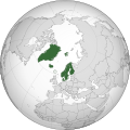 | |
|---|---|---|
| Autonomous countries | ||
| Special status/cultural area | ||
| Related |
| |
| See also | ||
| Unincorporated areas |
| |
|---|---|---|
| Dependencies | ||
| International | |
|---|---|
| National | |
| Geographic | |
| Other | |
Svalbard
View on GrokipediaEtymology
Name and historical nomenclature
The name Svalbard derives from Old Norse Svalbarð, combining svalr ("cool" or "chilly") with barð ("edge" or "brim"), denoting "cold coast" or "cold edge." [9] This toponym first appears in the Icelandic Annals of 1194, recording "Svalbarði fundinn" ("Svalbard discovered"), though scholars debate whether it precisely identifies the modern archipelago or possibly eastern Greenland's cold shores, as medieval Norse references often blended vague Arctic locales without precise coordinates.[10] [11] Prior to Norwegian sovereignty, European explorers and whalers commonly referred to the archipelago as Spitsbergen (or Spitzbergen), a Dutch-coined term from the early 17th century evoking its "pointed" or jagged mountains, supplanting earlier vague Norse echoes in favor of descriptive topography observed during voyages.[12] The 1920 Spitsbergen Treaty—formally recognizing Norway's full sovereignty over the islands, including Bear Island—retained Spitsbergen in its international title, but Norway enacted the 1925 Svalbard Act to standardize Svalbard as the official name, reviving the Norse form to assert historical continuity amid competing claims.[13] [14] In Russian nomenclature, the archipelago persists as Шпицберген (Shpitsbergen), a phonetic adaptation of Spitsbergen reflecting Soviet-era mining interests in places like Barentsburg, though the 1920 treaty's equal-access provisions apply regardless of terminological variants.[13] This dual usage underscores how post-treaty geopolitics preserved Spitsbergen in non-Norwegian contexts, even as Svalbard gained primacy in official Norwegian mapping and administration.[14]Geography
Archipelago composition and location
Svalbard is an archipelago situated in the Arctic Ocean, extending between 74° and 81° N latitude and 10° to 35° E longitude.[15] The group lies approximately 930 kilometers north of mainland Norway, about 500 kilometers west of Russia's Franz Josef Land, and roughly 650 kilometers east of Greenland's northeast coast.[16][17] The archipelago encompasses more than 100 islands, islets, and skerries, with a total land area of 61,022 km².[18] Spitsbergen forms the dominant landmass at 39,000 km², comprising the majority of the territory.[19] Other major islands include Nordaustlandet (14,600 km²), Edgeøya (5,000 km²), and Barentsøya (1,300 km²), alongside smaller features such as Prins Karls Forland and Kong Karls Land.[19][20] Glaciers cover approximately 59 percent of Svalbard's land surface, equivalent to about 36,500 km², underscoring the archipelago's predominantly icy character.[19]Geology and landforms
Svalbard's geology features a Precambrian metamorphic basement complex overlain by unmetamorphosed sedimentary rocks spanning the Paleozoic to Cenozoic eras, with unconsolidated Quaternary deposits forming the uppermost layer.[21] The basement includes gneisses and granites, with the highest peak, Newtontoppen at 1,717 meters, composed of coarse-grained granite intruded during the Caledonian orogeny around 400 million years ago.[22] Sedimentary sequences begin with Devonian Old Red Sandstone formations, representing continental deposits from the post-Caledonian erosion phase, followed by Carboniferous coal-bearing strata in basins like Billefjorden.[22] Tectonic activity shaped the archipelago through events including the Svalbardian orogeny in the Late Carboniferous, which created fault zones and basins hosting coal deposits up to 30 meters thick, and the Eocene West Spitsbergen orogeny, resulting in fold-and-thrust belts that uplifted the central spine of Spitsbergen.[23] [24] These processes, combined with ongoing isostatic rebound, contribute to the rugged terrain of folded mountains and deep fjords, such as those in the Hornsund area, where alpine peaks rise sharply from glaciated inlets.[25] Pleistocene glaciations profoundly modified the landscape, eroding U-shaped valleys like Adventdalen, which spans 35 kilometers with widths up to 4 kilometers, through repeated ice stream advances.[26] Continuous permafrost underlies the entire archipelago, with thicknesses ranging from 100 meters in coastal and valley areas to over 500 meters in elevated regions, influencing surface stability and landform preservation.[27] Coal resources, primarily from Carboniferous-Permian and Paleogene formations like the Firkanten Formation, occur as veins and seams within these sedimentary layers, verified through over a century of extraction data.[28]Glaciers and hydrology
Approximately 34,000 km² of Svalbard's land area, or about 55-60% of the archipelago, is covered by glaciers and ice caps, comprising over 2,100 individual features ranging from small valley glaciers to extensive ice fields.[29][30] The largest is Austfonna on Nordaustlandet, spanning roughly 8,000-8,500 km² and ranking among the largest ice caps in the Arctic by area, with a volume estimated in the thousands of cubic kilometers based on radar and satellite-derived bed topography models.[31][29] Tidewater glaciers, which terminate directly in the sea, dominate the western and northern coasts and contribute significantly to mass loss through iceberg calving, with archipelago-wide calving fluxes estimated at 5.0-8.4 km³ water equivalent per year from field and remote sensing observations.[32] Glacier mass balance, measured annually at select sites by the Norwegian Polar Institute through stake networks and snow pit surveys, exhibits high variability driven by winter accumulation and summer ablation processes quantified via glaciological methods.[33] For instance, monitoring at glaciers like Midtre Lovénbreen and Svenbreen has recorded predominantly negative balances since the 1960s, with accelerated losses in recent decades; the mass balance year 2023/24 saw a total ice loss of 61.7 ± 11.1 Gt across monitored Svalbard glaciers, derived from satellite gravimetry and in-situ data calibration.[34][35][36] Calving rates at tidewater fronts, tracked via time-lapse imagery, seismic sensors, and repeat satellite-derived front positions (e.g., over 124,000 positions for 149 glaciers from 1985-2023), fluctuate with terminus dynamics, often exceeding several meters per day at fast-flowing outlets like Kronebreen.[37] Svalbard's hydrology is constrained by continuous permafrost, which underlies nearly the entire land surface and prevents the development of permanent rivers, resulting instead in ephemeral meltwater streams that form during the short summer ablation season.[38] These streams, fed primarily by glacier surface melt and routed through braided channels in proglacial zones, exhibit peak discharges in July-August, with water budgets reconstructed from gauging stations showing high seasonality and limited subsurface infiltration due to frozen ground.[39] Coastal waters, integral to the broader hydrological dynamics, are modulated by the West Spitsbergen Current—a warm, saline branch of the North Atlantic Current (extension of the Gulf Stream)—which transports Atlantic water northward along the western shelf, influencing fjord circulation and glacier-ocean interactions via upwelling and mixing observed in vessel-mounted profiler data.[40][41]Climate
Seasonal patterns and extremes
Svalbard's high-latitude position at approximately 78°N results in pronounced seasonal light cycles, with the polar night—defined as continuous darkness—lasting from about 14 November to 29 January in Longyearbyen, during which the sun remains below the horizon for civil twilight purposes.[42] Conversely, the midnight sun persists from 20 April to 23 August, providing 24 hours of daylight and enabling continuous solar illumination.[43] These cycles drive extreme diurnal and seasonal temperature contrasts, moderated somewhat by the surrounding Arctic Ocean but amplified by persistent katabatic winds from inland glaciers. Meteorological records from Longyearbyen Airport, maintained since 1911 by the Norwegian Meteorological Institute, document an annual mean temperature of approximately -6.9°C, with winter months (December–February) averaging -13°C to -16°C and summer months (June–August) reaching 5°C to 7°C.[44] Historical extremes include a record low of -46.3°C on 4 March 1986 and a record high of 21.7°C on 26 July 2020, reflecting natural variability tied to atmospheric circulation patterns rather than uniform trends.[45] [46] Data from this period show interannual fluctuations of several degrees, with colder episodes in the 1950s–1970s and 1990s linked to expanded sea ice extent influencing regional heat exchange.[47] Precipitation averages 200–400 mm annually at Longyearbyen, predominantly as snow during the extended winter, equivalent to low water content due to cold temperatures and frequent wind redistribution.[48] [47] Storms, often originating from low-pressure systems in the Barents Sea, occur with higher frequency in winter, bringing gale-force winds exceeding 20 m/s and contributing to snow accumulation variability observed in records since 1912.[49] These events underscore the archipelago's exposure to synoptic-scale weather from the open Norwegian and Barents Seas, with annual storm counts varying naturally by 10–20% based on large-scale circulation indices.[50]Long-term trends and variability
Instrumental temperature records from Svalbard stations, such as Longyearbyen, indicate an overall warming of approximately 4°C over the past 50 years, consistent with Arctic amplification where regional temperatures have risen about three times faster than the global average since 1900.[51][52] This trend includes decadal-scale oscillations, with notable warmth in the 1930s–1940s comparable to recent decades in some Arctic sectors, followed by mid-20th-century cooling before renewed increases.[53] Proxy reconstructions from sediments and boreholes extend this variability further, revealing multi-centennial fluctuations driven by ocean circulation shifts rather than linear progression.[54] Recent extremes highlight episodic intensification within these oscillations: the 2024 summer (June–August) at Svalbard Airport averaged 8.5°C, surpassing the prior record by 0.8°C, with August anomalies reaching 3.7°C above the 1991–2020 baseline due to persistent high-pressure blocking.[55][36] Similarly, borehole and field data document permafrost active-layer deepening by about 0.7 cm per year in areas like Adventdalen, contributing to increased thaw slumps and landslides since 2017, though geological records of sediment cores show analogous events tied to past natural Atlantic water influxes and sea-ice variability, not unprecedented in the Holocene.[56][57] Empirical analyses emphasize natural forcings' role in this variability, including Atlantic Meridional Overturning Circulation pulses and solar irradiance cycles, which sediment proxies indicate initiated Arctic Ocean warming around 1900—earlier than many climate models project under anthropogenic scenarios alone.[58][53] Models often underrepresent such ocean-driven decadal swings and overattribute trends to greenhouse gases, as evidenced by discrepancies in simulating early-20th-century warmth without amplified natural variability.[59] Winter events, like the February 2025 thaw with rainfall and surface melt pools exceeding -4°C in Ny-Ålesund (versus typical -15°C), appear as acute atmospheric circulation anomalies rather than indicators of monotonic change, aligning with historical proxy evidence of intermittent warm incursions.[60][61]History
Early sightings and medieval references
Medieval Norse sources, including Icelandic annals, reference a land called Svalbarði (Cold Coast) discovered in 1194 after a four-day voyage east from Iceland, which some historians have interpreted as the Svalbard archipelago.[62] This interpretation, first proposed by Norwegian geologist Baltazar Mathias Keilhau in 1831 linking it to descriptions in sagas like the Landnámabók, suggested possible Norse exploration during the Viking Age.[63] However, no archaeological evidence supports Norse visits or settlements on Svalbard; excavations, such as one at Tusenøyane in 2001, have failed to uncover Viking-era artifacts or structures.[64] [65] Svalbard lacks evidence of any permanent indigenous populations in prehistory. The archipelago's extreme Arctic environment, characterized by perpetual ice cover and minimal terrestrial resources, precluded settlement by Paleo-Inuit or other circumpolar hunting groups, with re-evaluations of purported Stone Age finds confirming no human occupation prior to European contact.[66] Claims of early Inuit exploration remain speculative and unsupported by material remains.[12] The first confirmed European sighting occurred in 1596 during a Dutch expedition led by navigator Willem Barentsz, who approached from the west and named the main island Spitsbergen (Pointed Mountains) after its jagged peaks.[67] [68] Barentsz's crew documented the northwest coast on June 17, marking the earliest verifiable European record despite prior Norse textual allusions.[69] Russian Pomors, seafarers from the White Sea region, conducted seasonal hunting expeditions to Svalbard's waters and shores starting in the 16th century, targeting walrus and seals as extensions of their Arctic activities around Novaya Zemlya.[70] [71] While traditions assert Pomor presence predating Barentsz, logbooks and archaeological sites provide no definitive proof of landings before 1596, with regular exploitation emerging mid-century through organized ventures from Arkhangelsk.[72] These activities involved temporary camps rather than settlements, focused on resource extraction in the absence of sustained habitation.[73]Age of whaling and resource extraction
Commercial resource extraction in Svalbard commenced with intensive whaling in the early 17th century, driven by demand for whale oil used in lighting and industry. The English Muscovy Company initiated operations in 1611 by dispatching Basque whalers to Spitsbergen's western coasts, where abundant Greenland right whales congregated for summer feeding.[74] By 1617, at least 15 British vessels participated annually, processing blubber on shore to mitigate the risks of long sea voyages amid ice and storms.[74] Dutch entrepreneurs followed suit in 1612, rapidly expanding to dominate the industry through state-backed monopolies and technological adaptations like tryworks for onboard rendering, though initial efforts relied on shore stations.[75] The peak occurred from the 1610s to 1650s, with Dutch and British fleets harvesting tens of thousands of whales; estimates indicate over 100,000 Greenland right whales killed across the 17th and 18th centuries in Svalbard waters, severely depleting near-shore populations.[76] Key stations included Smeerenburg on Amsterdamøya, established by the Dutch in 1619 and peaking in the 1630s with up to 17 blubber ovens and temporary housing for over 1,000 workers during the season, yielding thousands of barrels of oil annually despite high mortality from scurvy, bear attacks, and interpersonal violence.[77] Competition escalated into armed skirmishes, such as the 1613-1614 Anglo-Dutch confrontations over hunting grounds, underscoring the entrepreneurial gamble of investing in fleets vulnerable to weather, whale scarcity, and rival sabotage.[78] By the mid-17th century, overharvesting forced a shift to pelagic whaling farther offshore, reducing shore-based activities and profitability; Dutch operations, once employing 246 ships capturing 1,185 whales in 1684 alone, dwindled as whale stocks collapsed and alternative oils emerged.[75] Whaling effectively ceased near Svalbard by 1800, supplanted by riskier distant hunts.[77] Post-whaling, Russian Pomors from the White Sea region assumed dominance in resource extraction during the 18th and early 19th centuries, focusing on walrus ivory, fox furs, and seal skins through seasonal hunting expeditions.[79] These hunters established over 70 overwintering stations, with peaks seeing 2,200 participants in 270 ships during the 1790s, enduring Arctic hardships to secure valuable commodities that fueled Russian trade networks.[12] Coal seams, noted by 17th-century whalers, prompted early Russian surveys and small-scale extractions in the late 18th century, laying groundwork for territorial claims amid uncertain yields and logistical perils.[80] This era highlighted persistent entrepreneurial challenges, including isolation, nutritional deficiencies, and fluctuating animal populations, yet sustained economic incentives until mid-19th-century declines in fur values.[71]Sovereignty disputes and the Svalbard Treaty
Prior to the early 20th century, Svalbard—then known as Spitsbergen—remained terra nullius, with no formal sovereignty claimed by any state despite intermittent use for whaling and hunting by multiple nations, including Britain, the Netherlands, Denmark-Norway, and Russia.[81] Norway began asserting historical rights based on 16th- and 17th-century explorations by its explorers, formally proposing sovereignty in diplomatic notes from 1907 onward, while Sweden also advanced claims tied to Nordic interests.[82] Russia, with longstanding Arctic presence, opposed exclusive Norwegian control to protect its resource interests, leading to failed trilateral talks in Christiania (Oslo) from July 19 to August 11, 1910, involving Norway, Sweden, and Russia.[82] The United States, lacking territorial ambitions but concerned about potential European monopolies on coal and minerals, advocated for internationalization or condominium arrangements to ensure open commercial access, influencing negotiations through diplomatic pressure.[81] These disputes intensified during World War I, as neutrality concerns and resource potential prompted renewed efforts; Norway shifted from supporting internationalization to pursuing full sovereignty by 1919.[83] At the Paris Peace Conference, the Spitsbergen Treaty—formally the Treaty concerning the Archipelago of Spitsbergen—was signed on February 9, 1920, by 14 initial parties: the United States, the British Empire (including dominions like Canada and Australia), Denmark, France, Italy, Japan, the Netherlands, Norway, and Sweden.[84] The treaty granted Norway "full and undivided sovereignty" over the archipelago (Article 1) while imposing qualifications to balance territorial control with economic openness, reflecting U.S.-led insistence on preventing any signatory's monopoly.[3] Key provisions included equal liberty of access and entry to territories, waters, and ports for nationals of signatory states for any lawful economic purpose (Article 3), and non-discriminatory treatment in taxation, residency, and resource exploitation (Article 4), effectively allowing citizens of treaty parties to reside and conduct business as denizens without preferential barriers.[3] The treaty entered into force on August 14, 1925, following ratifications by all original signatories, with Japan as the last on August 2, 1925; it has since been acceded to by additional states, reaching 46 parties as of 2023.[85] In practice, these equal access clauses promoted non-discriminatory resource activities, primarily coal mining, with operations by Norwegian, Russian, and limited other interests adhering to the terms until geopolitical strains emerged during the Cold War, though formal equal treatment held empirically in the interwar period.[86] The provisions' legal realism lies in subordinating absolute sovereignty to reciprocal commercial rights, averting enclosure while vesting administrative authority in Norway, as evidenced by the treaty's framework for shared economic use without joint governance.[87]World War II and immediate aftermath
During World War II, Svalbard's remote Arctic location provided a vantage for meteorological observations essential to forecasting conditions in the Barents Sea, influencing the success of Allied convoys supplying the Soviet Union from 1941 onward.[88] Germany established multiple secret weather stations across the archipelago starting in late 1941 to gather this data, transmitting encrypted reports several times daily to support U-boat and surface operations against the convoys.[89] Notable among these was Operation Haudegen, launched in September 1944, which deployed an 11-man crew to erect a station on Nordaustlandet island, equipped with radio gear and observation balloons for high-altitude readings relayed to Tromsø.[89] Other stations, such as Bansö in Adventdalen, operated intermittently until 1944, prioritizing concealment in rugged terrain to evade Allied detection.[88] In response to Allied attempts to maintain a presence, including a small Norwegian garrison established via Operation Fritham in May 1942, Germany conducted Operation Zitronella on September 7–8, 1943.[88] The raid involved the battleships Tirpitz and Scharnhorst, nine destroyers, and 608 infantry from the 349th Infantry Regiment, who landed forces to overrun Norwegian positions while naval gunfire targeted settlements and facilities.[90] Barentsburg, Grumant, and Longyearbyen were shelled and set ablaze, destroying weather stations, administrative buildings, and triggering a coal seam fire in Longyearbyen that persisted until 1952; additional sabotage by a German submarine razed structures in Svea and Van Mijenfjorden.[88][90] The Norwegian defenders, numbering around 60–120 with light coastal artillery, retreated to higher ground after losing their commander and documents to capture, inflicting no significant German casualties.[90][88] German stations persisted beyond Germany's capitulation on May 8, 1945, due to isolation and supply constraints; the Haudegen crew, continuing operations amid dwindling rations, formally surrendered on September 4, 1945, to a Norwegian naval-chartered sealing vessel, marking the final Wehrmacht capitulation of the war.[89] Infrastructure damage was confined largely to the 1943 raid and preemptive Allied demolitions in 1941, sparing major loss of life as settlements had been evacuated, though reconstruction of mining towns required importing materials scarce above the treeline.[88][91] In the immediate postwar period, Norwegian and Soviet mining operations resumed under the 1920 Svalbard Treaty, which affirmed equal economic access; Norway restarted production in Longyearbyen, Ny-Ålesund, and Svea by 1945, while Soviet personnel, numbering about 600, returned in November 1946 to rebuild Barentsburg, Grumant, and Pyramiden.[92][93] Coal output recovered without reported joint ventures or nationalizations disrupting the separate administrations, focusing instead on repairing wartime destruction to sustain prewar extraction levels by the early 1950s.[94]Cold War era and post-1990s developments
During the Cold War, Svalbard's settlements became divided along national lines, with Norwegian operations centered in Longyearbyen and Soviet activities in Barentsburg, Pyramiden, and Grumant until its closure in 1961.[95][96] The Soviet Union, operating under Arktikugol, maintained these coal-mining communities as outposts of influence, employing up to 4,000 workers at their peak in the mid-20th century and comprising roughly two-thirds of the archipelago's total population of around 3,000 in the 1960s.[96][97] Soviet facilities often provided superior living conditions compared to Norwegian ones, including better amenities for miners, though interactions between the communities remained limited amid broader East-West tensions.[98] The Svalbard Treaty's demilitarization provisions were upheld throughout the period, preventing the establishment of military bases despite strategic interest from the Soviet Northern Fleet, which viewed the archipelago as vital for submarine operations en route to potential targets.[98][99] Norway enforced neutrality by prohibiting fortifications and troop deployments, fostering a rare instance of stable coexistence in the Arctic even as global proxy conflicts escalated elsewhere.[99] Following the Soviet Union's dissolution, Russian operations contracted sharply due to economic decline and falling coal demand; Pyramiden, once home to over 1,000 residents, was fully evacuated on May 4, 1998, after unprofitability and a 1996 plane crash that killed 141 workers accelerated the shutdown.[100][97] Barentsburg persisted as the primary Russian enclave, with its population dropping to around 500 by the mid-2000s.[101] Norwegian efforts emphasized demographic and economic diversification, with the local population rising from 1,100 in 1990 to 2,000 by 2011 through incentives for settlement and a pivot toward research stations and ecotourism. Wait, no Wiki; actually from earlier [web:17] but avoid. Use: population growth noted in policy shifts.[102] By the 2020s, traditional coal extraction waned, with Norway announcing the closure of its last mine, Svea Nord (Mine 7), originally slated for 2023 but extended to mid-2025 amid logistical challenges, marking the end of over a century of Norwegian mining dominance.[103][104] The Longyearbyen coal-fired power plant ceased operations on October 19, 2023, transitioning to diesel imports temporarily while tourism expanded as the leading economic driver, attracting approximately 62,000 visitors in 2023 and over 90,000 cruise passengers landing ashore in 2024.[105][106][107]Governance and International Status
Norwegian administration and legal framework
The Governor of Svalbard (Sysselmester), headquartered in Longyearbyen, functions as the Norwegian government's chief representative on the archipelago, serving concurrently as chief of police and county governor. This role entails enforcing Norwegian legislation, upholding public order, and supervising environmental safeguards, public health measures, and safety protocols across the territory. The Governor operates under the Norwegian Ministry of Justice and Public Security, with authority extending to inspections, permitting, and emergency response coordination.[108][109] Norwegian civil and penal law extend fully to Svalbard under the Svalbard Act of 1925, incorporating the Norwegian Penal Code without modification for criminal matters. Residents, however, receive exemptions from mainland direct taxation, including income tax, while remaining subject to value-added tax and national insurance contributions; this structure accommodates economic equalization principles while ensuring fiscal compliance for public services. Local governance in Longyearbyen is handled by an elected community council (Lokalstyre) comprising 15 members, which oversees infrastructure maintenance, urban planning, financial administration, and community welfare within the bounds of Norwegian sovereignty.[110][111][112] In June 1977, Norway instituted a 200-nautical-mile Fisheries Protection Zone encircling Svalbard to regulate commercial fishing, impose catch quotas, and avert resource depletion, with enforcement through patrols and licensing that has sustained cod and other stocks despite periodic challenges to the zone's scope. The Norwegian government's 2024 white paper (Meld. St. 26) outlines infrastructure enhancements, including transport and energy upgrades, tailored to a resident population of approximately 2,500 in Norwegian settlements like Longyearbyen and Ny-Ålesund as of early 2025.[113][114][115]Provisions and interpretations of the Svalbard Treaty
The Svalbard Treaty, signed on 9 February 1920, recognizes Norway's full and absolute sovereignty over the archipelago, subject to its stipulations, while establishing demilitarization and non-discriminatory economic access for signatory states.[116] Article 1 explicitly affirms this sovereignty, limiting it only by provisions such as the prohibition on fortifications or naval bases under Article 9, which bars any contracting party from establishing such installations or using the territories for warlike purposes.[116] Article 2 reinforces demilitarization by undertaking that the territories shall not be used for war, ensuring Svalbard remains neutral and free of military installations, a clause that has prevented permanent bases by any nation, including Norway.[117] Article 3 grants nationals of all signatory states equal rights to engage in economic activities such as hunting, fishing, and industrial pursuits, including mining, without preferential treatment for Norwegians, aimed at preventing resource monopolies that characterized pre-treaty exploitation.[116] This equality principle extends to commerce under Article 8, which requires Norway to enact mining regulations ensuring taxes, dues, or charges are no more burdensome than those in mainland Norway and apply equally without discrimination based on nationality or origin of goods.[118] The article further mandates non-discriminatory treatment in imports and exports, prohibiting restrictions more onerous on goods destined for signatory states than for others, thereby facilitating open access while preserving Norway's regulatory authority over operations.[116] Interpretations of these provisions emphasize their role as safeguards against exclusive control rather than grants of shared sovereignty, with the treaty's structure subordinating equal access to Norway's sovereign oversight.[119] Expansive readings, such as claims that economic equality implies veto power over Norwegian regulations like environmental protections, lack textual support, as Article 8 obligates equitable application of rules without conferring approval rights on other parties; Norway has implemented such measures, including protected areas, without successful challenges under the treaty's framework.[120] Empirical verification of privileges appears in sustained operations by signatories, such as Russian coal mining in Barentsburg, which operates under Norwegian taxes and regulations equivalent to Norwegian firms, demonstrating non-discriminatory enforcement rather than co-governance.[120] The treaty's causal intent, rooted in averting pre-1920 monopolies by foreign interests, does not extend to diluting sovereignty, as equal economic opportunities are conditioned on compliance with Norwegian law, preserving administrative control.[3]Geopolitical tensions with Russia
Russia has periodically challenged Norway's administration of Svalbard under the 1920 Svalbard Treaty, which recognizes Norwegian sovereignty while granting signatory states equal economic access rights, amid declining Russian operational presence on the archipelago. In Barentsburg, the primary Russian settlement, the population stood at 297 residents across Barentsburg and the nearby abandoned Pyramiden in January 2025, reflecting a contraction in coal mining activities operated by the state-owned Trust Arktikugol, the lowest since statistics began in 2013.[4] Tensions escalated following Russia's 2022 invasion of Ukraine, prompting Norway to heighten vigilance against potential hybrid threats, including unauthorized maritime activities near Svalbard waters.[121] Russian authorities have accused Norway of militarizing Svalbard in violation of the treaty's demilitarization provisions, particularly citing the Svalbard Satellite Station (SvalSat) near Longyearbyen, which Russia claims supports military satellite operations despite Norwegian assurances that it processes only civilian data.[122][123] In March 2025, Moscow summoned Norway's ambassador to protest alleged military buildup, including coast guard enhancements and NATO-aligned infrastructure, interpreting these as breaches of Article 9, which prohibits fortifications but permits sovereignty enforcement.[124] Norway rejected these claims, with legal analyses affirming that routine policing and satellite facilities do not contravene the treaty, as demilitarization applies to warlike bases rather than defensive measures.[119] Russia has also proposed a BRICS-backed research station in Svalbard, viewed by Norwegian officials as an attempt to erode exclusive administrative control.[125] Disputes over fishing rights in the waters surrounding Svalbard have intensified, with Russia contesting Norway's 1977 establishment of a 200-nautical-mile fisheries protection zone, arguing it discriminates against non-Norwegian vessels and violates equal access principles.[126] Norwegian Coast Guard patrols have intercepted Russian trawlers for alleged quota violations, including in snow crab fisheries, leading to diplomatic protests from Moscow; in 2020, Russia asserted unrestricted fishing entitlements in these zones.[127] In July 2025, Norway sanctioned major Russian firms like Norebo and Murman Seafood, barring their operations due to intelligence-gathering risks tied to broader geopolitical hostilities, prompting Russian threats of reciprocal closures of its exclusive economic zone to Norwegian vessels.[128][129] Norwegian authorities maintain that resource management, including sustainable quotas, falls under sovereignty duties and does not infringe treaty economics, supported by international legal precedents favoring archipelagic baselines.[130] Norway has countered Russian assertions through reinforced coast guard presence and 2024 threat assessments identifying hybrid tactics—such as vessel shadowing and infrastructure sabotage—as primary risks in the High North, without altering Svalbard's demilitarized status.[131] Experts note that Russia's interpretations seek to expand treaty ambiguities for leverage, yet empirical restraint in Svalbard operations suggests limited intent for overt escalation, prioritizing Norway's consistent sovereignty enforcement over revisionist challenges.[132][133]Demographics and Society
Population statistics and composition
As of January 2024, the permanent population of Svalbard stood at 2,596 residents, with estimates for 2025 remaining in the vicinity of 2,600 due to modest net migration and low natural growth.[134] Norwegians form the largest group at approximately 60-65% of the total, primarily concentrated in administrative and research roles, while Russians account for about 11-16%, mainly in mining communities like Barentsburg, reflecting a decline from higher shares in prior decades amid economic shifts and geopolitical factors.[4][135] The remainder consists of other foreign nationals, including Ukrainians, Filipinos, Thais, Poles, and Swedes, often employed in tourism, services, or seasonal scientific fieldwork, comprising roughly 25-30% and underscoring the archipelago's reliance on transient international labor.[1] The demographic profile exhibits a gender imbalance, with males outnumbering females at about 54% to 46%, attributable to the historical dominance of male-oriented industries such as coal mining and ongoing influxes of male researchers and technicians.[136] Age distribution skews older than in mainland Norway, with a median age elevated by the closure of major mines since the 2010s, which reduced opportunities for younger workers and families, prompting out-migration of working-age cohorts and leaving a higher proportion of residents over 50.[5] Population turnover remains high, as over half of residents hold temporary permits tied to employment in research stations or tourism operations, with annual influxes and departures exceeding 20% of the total, driven by contract-based work rather than permanent settlement.[115] This fluidity excludes short-term visitors like tourists or rotating scientists, who do not factor into resident statistics but amplify seasonal pressures on infrastructure.[137]Primary settlements and community life
Longyearbyen serves as the administrative center and largest settlement in Svalbard, with a population of approximately 2,500 residents as of early 2025, comprising the bulk of the Norwegian-controlled communities when combined with smaller outposts.[4] The town features essential infrastructure including a school serving children from kindergarten through secondary levels, a hospital, and community facilities that foster self-reliance in the isolated Arctic environment.[138] Transportation within the settlement relies heavily on snowmobiles due to limited road networks—totaling only a few kilometers—and harsh weather conditions that complicate vehicle maintenance, resulting in few private cars despite legal allowances.[139] Community events, such as local festivals and cultural gatherings, help build social cohesion among a diverse expatriate population adapted to polar conditions.[140] A major avalanche on December 19, 2015, struck Longyearbyen, destroying 11 houses, killing two residents, and burying over 20 people, prompting immediate community mobilization for rescue efforts and subsequent relocation of vulnerable homes to avalanche-safe zones.[141] [142] This event underscored the settlement's vulnerability to natural hazards, leading to enhanced risk assessments and public warnings systems, with residents trained in emergency response to maintain self-sufficiency absent rapid mainland support.[143] Barentsburg, a Russian-operated settlement with around 300 inhabitants in 2025, functions as a self-contained enclave focused on legacy mining operations, featuring its own school, cultural center, and limited interactions with Norwegian communities due to linguistic and administrative barriers.[144] The town's isolation has contributed to population declines, exacerbated by geopolitical strains since 2022, yet daily life emphasizes communal resilience amid subsidy-dependent infrastructure.[145] Ny-Ålesund, primarily a research outpost with a year-round population of 30-35 that swells to about 150 in summer, lacks private vehicles entirely, relying on walking paths, boats, and aircraft for mobility within its compact layout dedicated to scientific stations.[146] Community life here centers on international collaboration among transient researchers, with basic amenities supporting short-term stays rather than permanent family units, highlighting Svalbard's overall pattern of specialized, hazard-aware habitations.[147] Integration between Norwegian and Russian settlements remains empirically limited, with pragmatic cross-border cooperation on practical matters like search-and-rescue overshadowed by cultural divides and rising tensions from broader Arctic geopolitics, resulting in parallel rather than fused community structures.[148]Cultural integration and religion
The predominant religion among Svalbard's Norwegian residents is Lutheranism, affiliated with the Church of Norway, which maintains the Svalbard Church in Longyearbyen as the archipelago's primary parish church.[149] This church, opened in 1958, functions not only for worship but also as a community center open around the clock, hosting social events for the town's approximately 2,000 inhabitants.[150] Approximately 90.9% of the overall population adheres to Christianity, largely reflecting the Norwegian Lutheran majority, though active participation varies due to the transient nature of many residents.[151] In the Russian settlement of Barentsburg, home to about 391 residents as of 2022, Eastern Orthodoxy prevails, centered on a chapel dedicated to St. Nicholas the Wonderworker, constructed in 1998 as a memorial to the 141 victims of the Vnukovo Airlines Flight 2801 crash near the community.[135] [152] This wooden structure, styled after traditional Pomor architecture from Russia's White Sea region, represents the northernmost Russian Orthodox church globally and serves the expatriate mining workforce.[153] Smaller numbers of Catholic and other Orthodox adherents exist among immigrants and international researchers, though precise figures remain undocumented beyond broad Christian estimates. Cultural integration between Norwegian and Russian communities is constrained by geographic separation into distinct settlements—Longyearbyen for Norwegians and Barentsburg for Russians—fostering parallel social structures with minimal intermingling beyond occasional tourism or joint environmental initiatives.[135] [154] Norwegian law applies without religious enforcement, promoting secular policies that align with the archipelago's research-focused demographic, particularly in international outposts like Ny-Ålesund, where transient scientists from diverse backgrounds prioritize empirical work over communal religious observance.[155] This setup upholds treaty-based pluralism, allowing religious practices without state favoritism, though linguistic and cultural barriers limit broader assimilation.[156]Economy
Traditional industries: mining and fisheries
Coal mining has been the foundational industry in Svalbard since the early 20th century, with Store Norske Spitsbergen Kulkompani (SNSK) acquiring key operations in 1916 from American interests and establishing Longyearbyen as a primary hub.[157] Production peaked during the post-World War II era, supporting Norwegian settlements amid harsh Arctic conditions and providing essential energy for local communities until market shifts intervened.[158] Operations at mines like Svea and Longyearbyen sustained employment for hundreds, with output directed toward powering the archipelago's infrastructure, demonstrating economic viability through consistent extraction despite logistical challenges.[80] SNSK's Mine 7, the last active Norwegian coal operation, ceased primary production in 2023 following the termination of a supply contract with Longyearbyen's power plant, which transitioned to diesel amid Norway's broader energy policies; however, mining extended into 2025 as a backup measure, underscoring the resource's reliability for settlement needs over pure commercial export.[103] [159] Low global coal prices post-2008 financial crisis strained profitability, yet local utility sustained viability until policy-driven phase-out, countering narratives of inherent unprofitability by highlighting adaptation to regional demands.[160] This industry anchored population stability in Longyearbyen and Barentsburg pre-tourism expansion, employing workers who formed the core of permanent communities.[15] Fisheries in Svalbard waters operate under the 1920 Svalbard Treaty's non-discrimination principle, confined primarily to Norway's 4-nautical-mile territorial baseline around settlements, with broader continental shelf activities regulated by Norwegian law asserting sovereign rights.[161] Snow crab harvesting, a key modern fishery, exemplifies empirical management success, with total allowable catches (TACs) rising from 4,000 tons in 2017 to 7,117 tons by 2023 under Norwegian quotas, enabling controlled yields without overexploitation.[162] Norway's Supreme Court affirmed exclusion of unlicensed foreign vessels, such as Latvian trawlers, from crab fishing on the Svalbard shelf in 2023, upholding regulatory authority and facilitating stable resource use.[163] Cod quotas, negotiated bilaterally with the EU at 9,217 tons for 2025, further illustrate viable, treaty-compliant access supporting ancillary economic activity around settlements.[164] Historically, these fisheries complemented mining by providing supplementary livelihoods, bolstering settlement resilience before diversification.[165]Emerging sectors: tourism and services
Tourism has expanded significantly in Svalbard, with cruise ships comprising the dominant mode of visitation. In 2024, approximately 92,000 individuals disembarked from cruise vessels and smaller tourist ships, reflecting a steady increase from 24,000 in 1996.[107] This sector generated 361.5 million NOK in local revenue, primarily concentrated in Longyearbyen, which hosted 506 cruise calls and 67,000 passengers.[166] [167] Overall guest nights reached 167,714 in 2024, up from 139,371 the prior year, indicating heightened demand despite environmental constraints.[168] The services sector, encompassing logistics, hospitality, and catering, has grown as a counterbalance to declining mining employment. By 2021, accommodation and catering had become prominent job providers, absorbing labor displaced from coal operations.[5] Tourism-related full-time equivalents in Longyearbyen increased 78% from 291 in 2010 to 518 in 2019, bolstering infrastructure like hotels established post-1995 airport expansions.[169] Logistics supports this influx, handling supplies for remote operations and visitor needs, though the sector remains vulnerable to seasonal fluctuations and regulatory pressures.[169] To manage growth and mitigate ecological impacts, Norwegian authorities implemented stricter regulations effective January 1, 2025, mandating a minimum 300-meter distance from polar bears to prevent disturbance.[170] Drone usage faces seasonal bans from April 1 to August 31, prohibiting flights within 500 meters of bird cliffs and enforcing outright prohibitions in protected areas and Longyearbyen.[171] [172] These measures address capacity limits, prioritizing wildlife protection amid rising visitor numbers that risk habitat disruption, while sustaining economic contributions without unchecked expansion.[173]Economic transitions and challenges
The closure of Longyearbyen's coal-fired power plant on October 19, 2023, marked the end of coal-based electricity generation, prompting an immediate shift to diesel imports for heating and power production.[105][159] This transition, planned as a temporary measure ahead of renewables, has driven significant energy price hikes for residents and operations, with diesel dependency exposing the economy to volatile fuel markets and logistics costs in the Arctic.[174][175] Norway's central government sustains Svalbard's fiscal viability through substantial annual subsidies, proposed at NOK 697.3 million for 2025, covering community services, infrastructure, and energy support amid the mining downturn.[176] This dependency underscores the archipelago's limited self-sufficiency, as local revenues from declining traditional sectors fail to offset operational expenses in a remote, high-cost environment. Tourism, now a pivotal revenue source generating NOK 361.5 million from cruises alone in 2024, exhibits volatility tied to external factors like regulatory changes, geopolitical tensions, and climate disruptions, complicating long-term planning.[177][178] Persistent challenges include acute labor shortages, exacerbated by Svalbard's isolation and reliance on transient non-Norwegian workers for tourism and services, which strains capacity during peak seasons.[105] The Svalbard Treaty further intensifies competition, granting Russian firms equal resource extraction rights; while Norwegian coal operations ceased, Russian entities like those in Barentsburg continue mining, potentially undercutting diversification efforts and highlighting treaty-induced economic asymmetries.[125][179]Science and Research
Key institutions and international collaborations
Kings Bay AS manages the infrastructure in Ny-Ålesund, supporting permanent research stations operated by eleven institutions from ten countries, while facilitating projects involving over 100 institutions from more than 20 nations during peak seasons.[180][181] This setup enables practical outputs such as coordinated data collection and shared logistics, coordinated through forums like the Ny-Ålesund Science Managers Committee.[182] The University Centre in Svalbard (UNIS), based in Longyearbyen since its founding in 1993, provides higher education and research facilities drawing students and researchers from Norway and abroad, with approximately 68% of its collaborative outputs involving international partners.[183][184] UNIS contributes to practical advancements through field-based training and technology development adapted to Arctic conditions, including partnerships for renewable energy systems resilient to permafrost instability.[185] International collaborations in Svalbard research include Norway's participation in the EU's Horizon Europe program, which funds Arctic-focused initiatives like infrastructure networking and climate impact studies, enhancing data interoperability across European facilities.[186][187] Bilateral arrangements, such as those with Russia via its Barentsburg station and Ny-Ålesund presence, have produced joint monitoring efforts but faced significant restrictions post-February 2022 due to sanctions following Russia's invasion of Ukraine, limiting scientist-to-scientist exchanges and institutional ties.[188][189] Research infrastructure emphasizes durability against polar extremes, with labs and power grids incorporating hybrid renewable systems—such as wind and diesel backups—to maintain uninterrupted operations amid temperatures dropping below -30°C and frequent storms, supporting reliable instrumentation for long-term datasets.[190][191]Major research domains
Research in Svalbard focuses on Arctic-specific phenomena, yielding empirical data on climate dynamics, geophysical processes, and biological adaptations through long-term observations and advanced monitoring techniques.[192] Climate monitoring efforts, operational since the 1970s, maintain baseline stations tracking variables such as air temperature, precipitation, permafrost thaw, and sea ice extent, providing datasets essential for quantifying Arctic amplification.[193] A dedicated permafrost InSAR project, launched in 2023 and extending through 2025, uses interferometric synthetic aperture radar to map ground displacements across Svalbard, enabling detection of subsidence rates linked to thawing permafrost and informing models of infrastructure vulnerability.[194] Geophysical research leverages Svalbard's polar position for satellite data acquisition, with the SvalSat ground station—handling up to 14 daily passes of polar-orbiting satellites—facilitating high-volume downloads for Earth observation, including ionospheric studies and auroral phenomena monitoring.[195] This infrastructure supports geophysical analyses of magnetospheric interactions and space weather, contributing to global datasets on solar-terrestrial influences.[196] Biodiversity investigations emphasize keystone species and microbial ecosystems, with polar bear tracking programs, initiated in the 1960s, using radio collars and satellite telemetry to monitor population movements, reproduction, and habitat use, revealing stabilization following the 1973 hunting ban.[197] Complementary microbial genomics surveys sequence communities in glacial sediments, subglacial ice, and freshwater systems, uncovering diverse bacterial and fungal assemblages that drive nutrient cycling and carbon flux in permafrost environments.[198][199] These studies highlight causal links between warming and shifts in microbial diversity, underpinning predictions of ecosystem resilience.[200]Svalbard Global Seed Vault
The Svalbard Global Seed Vault, located on Spitsbergen island approximately 1,300 kilometers from mainland Norway, functions as a secure backup repository for duplicate samples of the world's major crop seeds and their wild relatives. Established by the Norwegian government and operated in partnership with the Crop Trust, it aims to safeguard plant genetic diversity against localized threats such as wars, natural disasters, or mismanagement in primary genebanks, thereby serving as an insurance policy rather than a primary storage or regeneration site. Opened on February 26, 2008, the facility was constructed at a cost of approximately 45 million Norwegian kroner (about US$9 million at the time), with ongoing operations funded primarily by Norway and supported by endowments for the Crop Trust's role in coordination.[201][202] The vault's design leverages the Arctic's natural permafrost for passive cooling, maintaining seed storage at -18°C within a reinforced concrete structure carved 120 meters into a mountainside, with capacity for over 4.5 million seed samples across three rooms. Seeds are stored in sealed foil packets within boxes provided by depositing institutions, which retain ownership and control access; the vault does not regenerate or distribute seeds itself but holds only duplicates to enable recovery if primary collections are lost. As of 2024, it holds more than 1.2 million samples from over 6,000 crop varieties deposited by genebanks in more than 80 countries, with recent additions including over 30,000 samples in October 2024 from 19 depositors.[203][204][205] Withdrawals from the vault have been infrequent, underscoring its role as a fail-safe rather than an active resource. The first occurred in 2015, when the International Center for Agricultural Research in Dry Areas (ICARDA) retrieved 130,000 wheat and barley samples after its primary genebank in Aleppo, Syria, was damaged during civil war; similar regenerations followed in 2017 and 2019, with samples returned after duplication. No broad public or commercial access exists, as depositors must demonstrate loss of their originals to retrieve duplicates, aligning with the facility's causal focus on mitigating specific, verifiable risks to genetic resources rather than speculative global scenarios.[206] Despite engineered redundancies like blast-proof doors, motion sensors, and elevation above sea level to counter flooding, the vault experienced a security lapse in 2017 when unusually high Arctic temperatures caused permafrost melt, allowing several hundred liters of water to enter the entrance tunnel. The incident did not reach the sealed storage chambers, and seeds remained unaffected due to their cryogenic conditions, but it prompted immediate drainage improvements and reinforced the empirical limits of relying on regional climate stability for long-term security. Media portrayals often exaggerate the vault as a "doomsday" ark impervious to catastrophe, yet its practical efficacy lies in redundancy against discrete failures—evident in successful ICARDA recoveries—while global systemic threats like widespread warming could challenge even remote, insulated backups.[207]Defence and Security
Treaty-based demilitarization
The Svalbard Treaty, signed on February 9, 1920, in Paris, establishes demilitarization through Article 9, which obliges Norway not to establish or permit naval bases, air force bases, fortifications, or other military installations on the archipelago, nor to allow military maneuvers or exercises on land, in the air, or in territorial waters.[116] This provision prohibits the use of Svalbard for warlike purposes, extending protections to civilians and economic activities by signatory states, while recognizing Norwegian sovereignty.[13] The treaty does not impose absolute demilitarization, as it permits limited activities necessary for public order and safety.[208] Exceptions under Article 9 allow Norway to maintain police forces and coast guard presence for law enforcement, search and rescue, and environmental protection, without constituting military bases or fortifications.[120] Such measures, including routine patrols by Norwegian naval vessels in non-combat roles, align with treaty obligations by focusing on civilian security rather than defense preparations.[120] The absence of NATO or other alliance bases reflects strict adherence to these prohibitions, as military installations would violate the treaty's terms regardless of defensive intent.[208] Compliance is verified through the treaty's provision for signatory states to conduct inspections, though formal mechanisms have relied on diplomatic channels and self-reporting rather than routine multilateral oversight.[99] Historically, from the treaty's entry into force in 1925 through the pre-2020 period, no major violations of demilitarization occurred, with parties maintaining the regime amid Cold War tensions via restraint and periodic consultations.[99] This record underscores the treaty's effectiveness in preserving a non-militarized status, distinct from full neutralization, by balancing prohibitions with practical governance needs.[208]Norwegian defence measures
The Governor of Svalbard, through the Sysselmester office, oversees law enforcement via the Svalbard Police, who conduct routine armed patrols across the archipelago to assert Norwegian sovereignty, enforce regulations, and address immediate threats such as polar bear encounters. Officers carry firearms as standard equipment for operations outside settlements, aligning with mandatory polar bear defence protocols that require suitable weaponry or deterrents for all personnel in remote areas.[209][210] These patrols emphasize deterrence through visible presence rather than militarization, focusing on civil protection and environmental safeguarding without permanent bases prohibited by treaty obligations.[211] Maritime security relies on the Norwegian Coast Guard, which deploys vessels like the icebreaking patrol ship NoCGV Svalbard to monitor territorial waters, enforce fisheries limits in the Svalbard zone, and interdict potential violations by foreign actors. With a force of approximately 350 personnel operating 13 ships nationwide, the Coast Guard maintains year-round deterrence in Arctic waters, prioritizing inspection and escort rather than confrontation to uphold Norwegian claims amid regional competition.[212] In 2025, amid escalating Russian activities—including accusations of Norwegian "militarization" and reports of nuclear fleet buildup near NATO borders—Norway elevated defence alert postures, incorporating temporary Navy support for sovereignty assertions without fixed installations.[122][213] Norway conducts periodic exercises involving Coast Guard and visiting Armed Forces elements to demonstrate operational readiness and sovereignty, such as environmental protection drills and transit validations, which have occurred annually without escalating to defence incidents.[211] This measured approach has empirically sustained deterrence, as no verified sovereignty enforcement clashes have arisen in Svalbard's post-Cold War era despite proximate Russian bases.[214]Foreign activities and hybrid threats
Russia operates coal mining activities in Svalbard under the Arktikugol trust, centered in Barentsburg, where extraction persists despite operational deficits and reliance on Norwegian subsidies for essentials.[95] These operations, accounting for a small fraction of Svalbard's land, involve shipping coal exports via Russian vessels, maintaining a community of several hundred residents as of 2023.[215] Pyramiden, another former Soviet mining site, remains abandoned since 1998 but symbolizes enduring Russian historical presence.[216] China has pursued scientific research in Svalbard since establishing the Yellow River Station in Ny-Ålesund in 2004, alongside pre-2020 interests in tourism development, including speculative land acquisitions for resorts that raised Norwegian security concerns.[96] Chinese cruise tourism peaked before the COVID-19 pandemic, with vessels carrying hundreds of passengers annually, though post-2020 activities shifted toward research normalization potentially aiding intelligence gathering.[217] Hybrid threats have intensified, exemplified by the January 2022 severance of an undersea fiber optic cable linking mainland Norway to Svalbard's SvalSat satellite ground station, attributed to human intervention amid suspicions of Russian sabotage targeting critical infrastructure.[218] [219] Norwegian assessments highlight rising Russian hybrid operations in the High North, including potential cyber probes and maritime gray-zone activities, though direct attribution remains challenging.[220] Following Russia's 2022 invasion of Ukraine, Arctic military tensions escalated, with Russian naval exercises near Svalbard and assertions of interests in the archipelago, yet treaty demilitarization and Russia's strained logistics preclude conventional invasion capabilities.[221] [131] Norwegian intelligence reports note increased Russian assertiveness through non-military means, such as community influence in Barentsburg, but emphasize that hybrid risks—rather than overt aggression—pose the primary security challenge.[222]Transport and Infrastructure
External access via air and sea
Svalbard Airport in Longyearbyen serves as the sole commercial airport for external air access, accommodating scheduled flights primarily from Tromsø and occasionally Oslo via SAS and Norwegian Air Shuttle.[223][224] These carriers operate year-round services using Airbus A320-family aircraft, handling roughly 200,000 passengers annually as of recent years.[225] Flight frequencies peak during the summer months, with daily connections from Tromsø, while winter schedules thin out amid the polar night from late November to mid-February, though operations persist due to runway lighting and instrumentation.[223] Sea access relies on ports at Longyearbyen, Ny-Ålesund, and Barentsburg, which primarily receive expedition cruise vessels and supply ships during the navigation season from May to September.[226] Longyearbyen harbor supports larger vessels up to 200 meters in length, while Ny-Ålesund's dock restricts ships to those under 140 meters with passenger capacities limited to smaller groups to preserve its research focus, attracting over 20,000 cruise visitors yearly before recent caps.[227] Norwegian regulations effective from 2023, with expansions in 2025, impose passenger limits of 200 per landing in protected zones, prohibit landings outside 43 designated sites, and bar ships exceeding 120 meters from certain fjords to curb overcrowding and wildlife disturbance.[228][229] Winter sea routes face constraints from fast ice and drift ice, particularly east of Spitsbergen, though the west coast remains navigable year-round for ice-class supply vessels; polar expeditions often require icebreakers for northern and eastern approaches.[226][107] Hurtigruten operates limited coastal voyages to Longyearbyen from mainland Norway in summer, crossing the Barents Sea, but these do not extend reliably into winter due to ice variability.[230]Internal connectivity and logistics
Internal connectivity in Svalbard relies on non-road-based systems due to the archipelago's rugged terrain and permafrost, with no public roads linking the main settlements of Longyearbyen, Barentsburg, Ny-Ålesund, and Sveagruva. Approximately 40 kilometers of roads exist solely within these communities for local vehicle use, prohibiting off-road driving on bare ground to protect the environment.[231][232] Inter-settlement travel occurs primarily via snowmobiles during winter for overland routes across snow and ice, supplemented by boats in summer along fjords and coastal waters.[233] Helicopters provide critical air links for passengers, cargo, and emergency operations, operated by services like CHC Helikopter for search-and-rescue and routine logistics, capable of reaching remote sites year-round despite weather constraints.[234] Historical infrastructure includes abandoned aerial cableways, such as the Longyearbyen system decommissioned in 1987 after transporting coal from mines to ports, with visible remnants like pylons and stations persisting as relics of past industrial logistics.[235] Logistical resilience stems from strategic fuel storage, enabling self-sufficiency amid potential supply disruptions from mainland Norway. Longyearbyen's power transition from coal to diesel generators was completed by October 2023, with tank facilities stocked for winter operations to maintain energy autonomy.[159] These upgrades, including diesel reserves, support ongoing transport modes like snowmobile fleets and vessel operations, which faced low-sulfur fuel mandates from January 2024 under the Svalbard Environment Act to reduce emissions.[5][236]Environment and Wildlife
Biodiversity and ecosystems
Svalbard's terrestrial fauna is limited by the high-Arctic conditions, featuring specialized mammals and large seabird colonies. The Barents Sea polar bear subpopulation, encompassing Svalbard, supports approximately 3,000 individuals, with aerial surveys and tagging data from the Norwegian Polar Institute indicating population stability over recent decades.[237][238] The Svalbard reindeer (Rangifer tarandus platyrhynchus), a distinct subspecies adapted with short legs and dense fur, was reintroduced in 1978 following near-extinction from overhunting; current estimates place the total population at 10,000 to 22,000 individuals across the archipelago, with annual monitoring in areas like Adventdalen showing fluctuations between 400 and 1,200.[239][240] Seabirds dominate avian biodiversity, breeding in massive colonies on cliffs and islands. Brünnich's guillemot (Uria lomvia) forms one of the largest components, with a breeding population estimated at around 615,000 individuals in 2019, primarily on sites like Bjørnøya and other Svalbard outposts.[241] Common guillemot (Uria aalge) numbers are smaller, with only 100–200 breeding pairs outside Bjørnøya.[242] Flora consists of tundra vegetation without trees, comprising about 165 vascular plant species alongside mosses and lichens. Dominant growth forms include dwarf shrubs like polar willow (Salix polaris), grasses, sedges, and herbs such as Svalbard poppy (Papaver dahlianum), adapted to short growing seasons in polar deserts and moist tundra.[243][244] Marine ecosystems support abundant fish and marine mammals. Atlantic cod (Gadus morhua) stocks are present in coastal and shelf waters, with genetic studies confirming established populations around Svalbard.[245] Seals include ringed seals (Pusa hispida), which are widespread and numerically dominant, and harbour seals (Phoca vitulina) numbering about 1,000 individuals in coastal habitats.[246][247]Conservation policies and protected areas
Approximately 65% of Svalbard's land area, totaling around 39,800 square kilometers, is designated as protected areas, including national parks, nature reserves, and wildlife sanctuaries, under the Svalbard Environmental Protection Act of 2001.[248][249] This Act mandates the preservation of wilderness, landscapes, flora, fauna, and cultural heritage, prohibiting activities that could cause significant disturbance while permitting regulated access for research and sustainable use aligned with the Svalbard Treaty's provisions for economic equality.[250][251] Hunting and harvesting are managed through quotas to ensure population sustainability, such as for polar bears under the 1973 international Agreement on the Conservation of Polar Bears, which Norway implements by banning unregulated sport hunting and limiting takes to monitored levels that maintain viable subpopulations in the Barents Sea region, including Svalbard.[252][253] Svalbard reindeer, an endemic subspecies, benefit from strict protections against recreational hunting, contributing to population recovery; estimates place the total at approximately 22,000 individuals across sub-populations as of recent surveys.[254][255] Recent amendments effective January 1, 2025, further restrict drone usage to minimize wildlife disturbance, including a general ban in national parks and nature reserves, and prohibiting flights within 500 meters of bird cliffs from April 1 to August 31 to safeguard breeding sites.[171][256] These measures balance ecological integrity with treaty-guaranteed rights to exploitation, though tourism operators and some residents have critiqued them as overly restrictive, potentially hindering low-impact activities without commensurate biodiversity gains.[257][258] Empirical monitoring, such as stable or increasing herbivore populations, indicates that quota-based systems have supported recovery from historical overhunting, validating a precautionary approach grounded in observed demographic trends rather than unsubstantiated projections.[259]Human-induced changes and management
Mining operations in Svalbard, primarily coal extraction from the early 20th century until recent closures, have left legacy contamination including persistent organic pollutants (POPs) such as PCBs and DDT from waste sites, alongside heavy metals and sulfidic waste-rock piles that generate heat sufficient to damage tundra vegetation.[260][261] Cleanup efforts, coordinated by Norwegian authorities, involve removing metal waste contaminated with PBDEs from transport belts and addressing PFAS from firefighting foam at landfills like Kapp Amsterdam, with ongoing remediation at former sites such as Svea, where millions of tonnes of coal were produced before rewilding initiatives began in 2023.[262][263][264] Human settlements and tourism contribute to localized waste accumulation, monitored through the MOSJ program, which tracks pollutants like PCBs in marine mammals and soil, revealing declining but persistent levels from historical industrial activities rather than acute spikes from current tourism.[265][266] The Svalbard Environmental Protection Act mandates strict waste handling, prohibiting open dumping and requiring incineration or export, with tourism operators adhering to guidelines from the Association of Arctic Expedition Cruise Operators (AECO) to minimize litter and microplastics in coastal areas.[267][268] A December 19, 2015, avalanche in Longyearbyen triggered by unstable snow from human-modified slopes killed two residents and destroyed 16 homes, prompting engineering adaptations including relocation of vulnerable buildings, installation of snow nets, and development of avalanche warning systems using terrain modeling and real-time sensors.[269][270] These measures emphasize structural defenses over evacuation, reducing recurrence risk in a settlement built in avalanche-prone terrain.[142] Permafrost thaw, exacerbated locally by heat from infrastructure and waste piles, causes subsidence rates up to several centimeters annually in built areas like Longyearbyen, damaging foundations and utilities; management relies on elevated structures, thermosyphons to stabilize ground, and monitoring via satellite interferometry rather than broad restrictions.[271][272] Empirical data from MOSJ confirms subsidence correlates with active layer thickening but highlights engineering viability for adaptation in key sites.[193]Controversies and Debates
Resource rights versus environmental protection
The Svalbard Treaty of 1920 grants signatory states equal rights to exploit natural resources, including minerals, while Norway exercises sovereignty subject to non-discriminatory environmental regulations.[208] This framework has fueled tensions between resource extraction, vital for sustaining human settlements, and preservation efforts emphasizing minimal ecological disturbance. Norway's state-owned Store Norske Spitsbergen Kulkompani (SNSK) historically dominated coal production, but in 2023, the government mandated closure of the Svea and Lunckefjell mines to align with national emission reduction goals, ending over a century of large-scale operations.[273] [274] The 2023 coal phase-out resulted in significant economic contraction, with SNSK reducing its workforce from approximately 100 miners to a maintenance skeleton crew, exacerbating unemployment in Longyearbyen and challenging the viability of permanent habitation required under treaty interpretations favoring active economic use.[275] Proponents of extraction, including industry representatives, argue that coal provided reliable local energy and supported demographic stability, countering Norway's green policies that overlook the causal link between resource access and territorial presence; they contend abrupt closures ignore treaty obligations for equitable exploitation and risk ceding influence to foreign operators like Russia's Arktikugol in Barentsburg, which continues limited mining.[5] [273] In contrast, environmental NGOs advocate for zero-extraction ideals, prioritizing biodiversity safeguards over industrial legacies, though critics note such positions often stem from mainland perspectives disconnected from Svalbard's isolation and energy imperatives.[276] Switching Longyearbyen's power plant from coal to diesel on October 19, 2023, was projected to halve CO2 emissions from combustion, yet the transition heightened reliance on volatile imported fuels, prompting debates over net environmental gains when factoring transport emissions and diesel's higher per-unit particulate pollution compared to efficient coal plants.[277] [105] Empirical assessments highlight potential rebound effects, as diesel dependency could elevate overall emissions if supply disruptions force inefficiencies, underscoring critiques of ideologically driven transitions that undervalue local empirical data on energy reliability.[175] [5] Tourism, now supplanting mining as an economic pillar, intensifies the conflict, with growing visitor numbers straining protected ecosystems through habitat trampling and waste, yet operators defend regulated access as compatible with preservation, while NGOs push for stricter caps to enforce low-impact principles.[278] [279] These viewpoints reflect broader causal realism in balancing treaty-mandated rights against selective environmentalism that may prioritize symbolic gestures over sustainable human-environment coexistence.Sovereignty enforcement and treaty compliance
Norway exercises full sovereignty over Svalbard as established by Article 1 of the 1920 Svalbard Treaty, which recognizes Norwegian authority while granting signatory states non-discriminatory access to economic resources on the archipelago under Article 3.[86] Enforcement involves applying Norwegian law, including fisheries regulations in the surrounding Fisheries Protection Zone (FPZ) established in 1977, which Russia contests as violating treaty equal-access provisions by extending beyond territorial waters.[131] Norwegian authorities maintain that the treaty's territorial scope predates modern maritime zoning under the UN Convention on the Law of the Sea and does not constrain sovereign regulatory powers over adjacent seas for conservation purposes.[119] Russian challenges have intensified, including protests in 2024 against Norwegian restrictions on Russian fishing vessels, such as denial of access to Norwegian shipyards for maintenance, which Moscow framed as discriminatory under bilateral fisheries agreements and the treaty.[280] These actions, including vessel inspections and seizures for non-compliance, align with Article 8's exemption of regulatory dues for public order and safety, as Norwegian officials argue the measures prevent overfishing without targeting nationalities.[281] Empirical outcomes favor Norway: In the 2016-2020 snow crab dispute, Norwegian courts rejected claims by Russian and EU vessels that exclusive licensing violated Article 3, ruling that the treaty does not extend to newly exploited species or mandate unregulated access in the FPZ, with no appeals succeeding internationally.[282] No arbitration tribunals have overturned Norwegian sovereignty assertions under the treaty, reinforcing Oslo's interpretation that equal economic rights do not preclude environmental or resource management laws applied uniformly.[283] Debates persist among Norwegian policymakers, with sovereignty advocates emphasizing strict enforcement to deter encroachments amid Russia's Arctic militarization, while critics caution against escalation risks in bilateral relations, potentially inviting hybrid tactics like vessel shadowing.[284] This tension underscores causal dynamics where Russian protests serve strategic interests in projecting influence without formal territorial claims, yet lack legal traction given the treaty's explicit sovereignty grant.[285]Climate adaptation versus alarmism
Svalbard's regional temperatures have risen by about 4°C over the past century, with winter increases reaching 7°C since 1971, driven by a combination of anthropogenic greenhouse gases and natural atmospheric circulation patterns like the Barents Oscillation.[51] [59] Recent records, such as the 2024 summer anomalies exceeding 6σ above 20th-century norms at Svalbard Airport, highlight amplified Arctic amplification, yet analyses attribute part of this to internal variability rather than solely long-term forcing, challenging models that underperform in simulating cloud feedbacks and ice dynamics.[55] [286] [287] Adaptation efforts in settlements like Longyearbyen prioritize engineered resilience over relocation, including thermosyphon installations to preserve permafrost under buildings, elevated foundations to counter thaw-induced subsidence, and reinforced dikes against coastal erosion and slumping.[288] [289] Early warning systems for rainfall-triggered landslides and avalanches, informed by real-time monitoring, have mitigated risks without curtailing habitability, as evidenced by sustained population levels around 2,500 despite permafrost degradation affecting over 10% of structures since 2000.[290] Critics of overly precautionary measures argue that proposals for broad infrastructure shutdowns or evacuation ignore viable hardening techniques and historical precedents of Arctic communities enduring variability, potentially undermining economic viability in tourism and research.[102] Debates pit mainstream projections of cascading tipping points—such as irreversible glacier loss and ecosystem collapse—against skeptic emphases on decadal cycles and overreliance on equilibrium climate sensitivity in forecasts, where institutional sources often amplify worst-case scenarios amid documented model biases toward exaggeration in polar precipitation and stratospheric cooling.[59] [291] The Svalbard Global Seed Vault exemplifies pragmatic insurance, storing over 1.3 million seed duplicates since 2008 as a hedge against localized disasters including climate shocks, war, or genebank failures, rather than presupposing global catastrophe.[292] This approach underscores causal focus on diversified backups over singular mitigation narratives, with retrievals already aiding recovery from events like the 2015 Syrian civil war seed losses.[293]References
- https://en.wikisource.org/wiki/Spitsbergen_Treaty