Hubbry Logo
Borders of the Roman EmpireBorders of the Roman EmpireMain
Open search
Borders of the Roman Empire
Community hub
Borders of the Roman Empire
logo
8 pages, 0 posts
0 subscribers
Be the first to start a discussion here.
Borders of the Roman Empire
from Wikipedia
  Roman Empire at its greatest extent in AD 117
Map of the Roman Empire in 125 during the reign of emperor Hadrian

The borders of the Roman Empire, which fluctuated throughout the empire's history, were realised as a combination of military roads and linked forts, natural frontiers (most notably the Rhine and Danube rivers) and man-made fortifications which separated the lands of the empire from the countries beyond.

Limes

[edit]
The limes that protected the Empire from German raids.

The word limes is sometimes used by modern scholars to denote the frontier of the Roman Empire but was not used by the Romans as such. After the third century it was an administrative term, indicating a military district, commanded by a dux limitis.[1]

The Latin noun limes had a number of different meanings: a path or balk marking off the boundaries of fields; a boundary line or marker; any road or path; any channel, such as a stream channel; or any distinction or difference between two things.

In Britannia the Empire built two walls one behind the other; for Mauretania there was a single wall with forts on both sides of it. In other places, such as Syria and Arabia Petraea, there was no continuous wall; instead there was a net of border settlements and forts occupied by the Roman army. In Dacia, the limes between the Black Sea and the Danube were a mix of the latter and the wall defenses: the Limes Moesiae was the conjunction of two, and sometimes three, lines of vallum, with a Great Camp and many minor camps spread through the fortifications.[citation needed]

The northern borders

[edit]
Location of Hadrian's Wall and the Antonine Wall in Scotland and Northern England.

In continental Europe, the borders were generally well defined, usually following the courses of major rivers such as the Rhine and the Danube. Nevertheless, those were not always the final border lines; the province of Dacia, modern Romania, was completely on the far side of the Danube, and the province of Germania Magna, which must not be confused with Germania Inferior and Germania Superior, was the land between the Rhine, the Danube and the Elbe (Although this province was lost three years after its creation as a result of the Battle of Teutoburg Forest).

In Great Britain both Hadrian and Antoninus Pius built defences to protect the province of Britannia from the Caledonians. Hadrian's Wall, constructed in 122 held a garrison of 50,000 soldiers, while the Antonine Wall, constructed between 142 and 144, was abandoned by 164 and briefly reoccupied in 208, under the reign of Septimius Severus.

The Pannonian Limes

[edit]
Map of Limes in Slovakia, Hungary, Croatia and Serbia

The eastern borders

[edit]

The eastern borders changed many times, as the Roman Empire was facing two major powers, The Parthian Empire and the Sasanian Empire. The Parthians were a group of Iranian peoples ruling most of Greater Iran that is in modern-day Iran, western Iraq, Armenia and the Caucasus.[2] The Sasanians succeeded the Parthians in 224–226 and were recognised as one of the leading world powers alongside its neighbouring arch-rival the Roman (Byzantine) Empire for a period of more than 400 years.[citation needed]

The southern borders

[edit]
Limes Africanus under Septimius Severus (The frontier of Roman Africa (dark tan) in the late 2nd century AD: Septimius Severus expanded the Limes Tripolitanus dramatically (medium tan), even briefly holding a military presence (light tan) in the Garamantian capital Garama in 203)

At the greatest extent of the Empire, the southern border lay along the deserts of Arabia in the Egyptian region and the Sahara in North Africa, which represented a natural barrier against expansion. The Empire controlled the Mediterranean shores and the mountain ranges further inland. The Romans attempted twice to occupy the Siwa Oasis and finally used Siwa as a place of banishment. However, the Romans controlled the Nile many kilometres into Africa up to Syena, Berenice, Hyerasykaminos and even Qasr Ibrim (the southernmost of all), near the modern border between Egypt and Sudan. The period in which each aforementioned town represented the final frontier of Rome is uncertain.

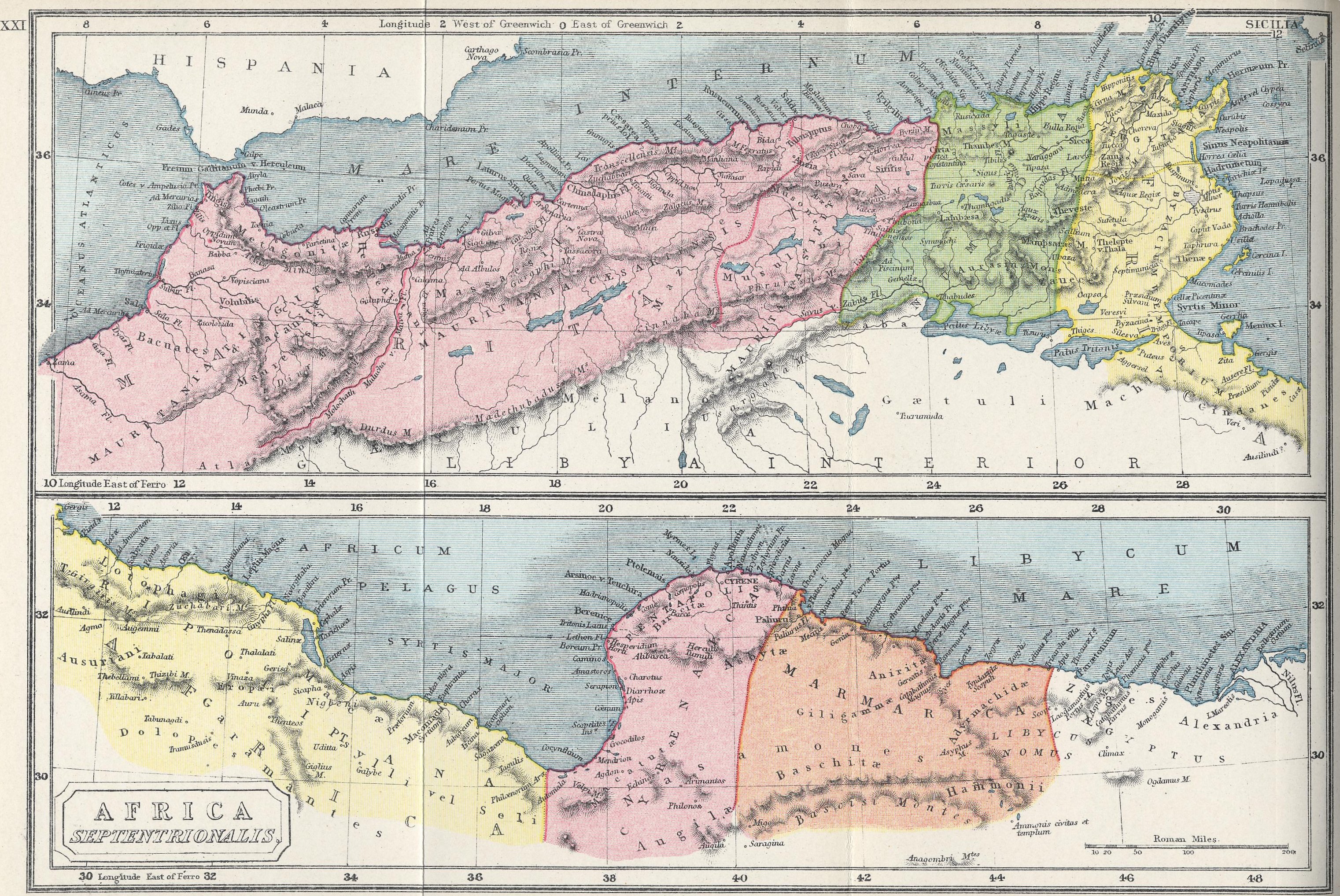
In Africa the Romans controlled the area north of the Sahara, from the Atlantic Ocean to Egypt, with the borders being controlled by many sections of fortifications such as the Limes Arabicus (called the Limes Uranus), Limes Mauretaniae, Fossatum Africae, Fossa Regia, Limes Tripolitanus, Limes Numidiae, etc.[3]

In the south of Mauritania Tingitana Romans made a limes in the third century, just north of the area of actual Casablanca near Sala and stretching to Volubilis.

Septimius Severus expanded the "Limes Tripolitanus" dramatically, even briefly holding a military presence in the Garamantian capital Garama in AD 203. Much of the initial campaigning success was achieved by Quintus Anicius Faustus, the legate of Legio III Augusta.

Following his African conquests, the Roman Empire may have reached its greatest extent during the reign of Septimius Severus,[4][5] under whom the empire encompassed an area of 5 million square kilometres (2 million square miles).[4]

Tabula Peutingeriana

See also

[edit]

References

[edit]

Bibliography

[edit]

Further reading

[edit]
[edit]
Revisions and contributorsEdit on WikipediaRead on Wikipedia
from Grokipedia
The borders of the Roman Empire, known collectively as the limes, constituted a vast and varied system of fortifications, roads, forts, watchtowers, and natural barriers that delineated the empire's territorial limits from the late Republic through the fall of the West in the 5th century AD. These frontiers reached their maximum extent under Emperor Trajan in 117 AD, encompassing approximately 5 million square kilometers across Europe, North Africa, and the Near East. Totaling around 7,500 kilometers in length, the limes traversed diverse terrains, from the Rhine and Danube rivers in central Europe to desert outposts in North Africa and walls like Hadrian's in Britain. Primarily defensive in function, the borders aimed to control cross-frontier movement, deter raids by external tribes such as Germanic peoples and Parthians, and facilitate Roman economic and military projection rather than serving as absolute barriers to invasion. Archaeological evidence reveals a progression from open-ended expansion under the early emperors to more rigid demarcation by the 2nd century AD, exemplified by Hadrian's Wall—constructed in 122 AD across northern Britain to separate Roman territory from Caledonian tribes—and the Upper Germanic-Rhaetian Limes, a UNESCO-recognized chain of earthworks and stone walls along the empire's northern edge. This system not only reflected Rome's adaptive military strategy but also enabled cultural and commercial exchanges across permeable zones, though it faced persistent challenges from migrations and rebellions that ultimately contributed to imperial contraction.

Conceptual Framework

Definition and Terminology

The borders of the Roman Empire denoted the outer limits of territories under direct Roman administrative and military control, typically secured by a network of fortifications, roads, and natural barriers such as rivers, deserts, and mountains, rather than rigid linear demarcations characteristic of modern nation-states. These frontiers served primarily as zones for projecting power, monitoring movement, and regulating interactions with external groups, allowing for permeability in trade and diplomacy while enabling rapid military response to threats. Unlike contemporary concepts of impermeable sovereign boundaries, Roman borders emphasized functional control over ethnographic or legal exclusivity, with fluctuations tied to conquests, withdrawals, and alliances documented from the late Republic through the 5th century AD. The primary Latin term for these frontier systems was limes, originally signifying a cleared path or track used by surveyors to mark boundaries between land plots while providing access between them, as evidenced in Republican-era agrarian contexts. By the early Empire, particularly from the reign of (27 BC–AD 14), limes evolved to describe militarized boundary roads lined with watchtowers, forts, and barriers, such as the Upper Germanic Limes constructed between approximately AD 90 and 160, extending over 550 kilometers from the to the . This usage, appearing in inscriptions and military diplomas like those from AD 107 onward, highlighted not a sealed barrier but an organized defensive integrating legions and auxiliary cohorts for patrol and deterrence. Associated terminology included , referring to border troops stationed along the limes from the late 3rd century AD under emperors like (r. AD 284–305), distinguishing them from mobile field armies () and reflecting a shift toward static frontier garrisons amid increasing external pressures. Earlier designations, such as ripa for riverine frontiers like the or , emphasized natural features augmented by artificial defenses, while provincial boundaries (fines provinciae) separated internal administrative units but lacked the militarized connotation of external limes. Modern scholarship, drawing on epigraphic and archaeological evidence, cautions against anachronistic interpretations of limes as a "hermetically sealed" , noting its role in facilitating rather than wholly prohibiting cross-frontier activity, as seen in 2nd-century trade records from sites like .

Strategic Purposes and Functions

The borders of the Roman Empire, known as limes, primarily served to demarcate Roman territory from unconquered regions, utilizing a combination of natural barriers like rivers, artificial structures such as walls and palisades, and a network of forts, watchtowers, and roads spanning over 5,000 kilometers at their peak in the AD. This system evolved pragmatically without a centralized , adapting to local threats and to maintain imperial stability rather than pursuing endless expansion after the early imperial period. Militarily, the limes functioned as a defensive zone for early detection and rapid response to incursions, with watchtowers enabling to rear forts for deploying or , as seen in the - frontier where wooden towers monitored barbarian movements. Structures like , constructed between AD 122 and 130 and extending 118 kilometers across northern Britain with milecastles and turrets, created a controlled barrier against Caledonian raids, supported by 16 forts housing auxiliary troops totaling around 10,000-15,000 soldiers. Similarly, the Upper German-Raetian Limes, approximately 550 kilometers long, integrated palisades, ditches, and over 100 forts to secure the frontier, allowing segmented defense rather than a continuous impermeable line, which proved effective against Germanic tribes until the crises. These installations also projected power offensively, serving as bases for punitive expeditions and logistics, such as launching campaigns beyond the under emperors like . Beyond defense, the limes regulated cross-border movement and , enforcing duties and formal trading posts to control goods flow and curb , particularly along the where military oversight integrated barbarian economies via Roman coinage, evidenced by over 220 denarii hoards in Magna. presence stimulated local economies through infrastructure like roads and river ports, fostering vici ( settlements) that exchanged , glassware, and foodstuffs, while demand for supplies created workshops and supply chains. Administratively, boundary markers and patrols asserted Roman legal , psychologically reinforcing imperial dominance and cultural separation, as non-Roman areas remained outside direct governance to avoid overextension. This multifaceted approach prioritized sustainable control over conquest, adapting to fiscal constraints by the under Hadrian's consolidation policies.

Historical Evolution

Republican-Era Frontiers

During the (509–27 BC), frontiers were not demarcated by extensive fortified lines as in the later Empire but functioned as dynamic zones of military control, administrative oversight, and tributary relationships, often exploiting natural barriers like rivers and mountains while relying on mobile legions and client alliances rather than static defenses. This approach stemmed from Rome's origins as an expansionist , where borders evolved through conquest rather than deliberate border-building, with provincial governors wielding to manage threats ad hoc. Stephen L. Dyson argues that these Republican practices in western provinces, such as iterative campaigns against indigenous groups, originated the core methods of Roman border control, including fort construction and pacification strategies that influenced imperial policy. Provincial boundaries were defined by senatorial decrees, typically following rivers (e.g., the Iber in ) or ethnic divisions, but remained porous, permitting trade and raids until subdued. The unification of Italy marked the initial phase of frontier formation, with Rome defeating Latin, Samnite, and other Italic peoples by 272 BC, establishing dominance south of the Po River through colonies and foedera treaties that integrated allies without formal borders. Cisalpine Gaul beyond the Po remained a contested northern frontier, with incursions by Gauls prompting campaigns like those of Marcellus in 222 BC and Marius against the Cimbri and Teutones in 101 BC, securing the region up to the Alps but without permanent fortifications. Overseas expansion began with the First Punic War (264–241 BC), yielding Sicily as Rome's first province, whose eastern boundary followed the Syracusan hinterland and western edge abutted Carthaginian remnants until fully pacified. Sardinia and Corsica were annexed in 238 BC as a combined province, with minimal defenses relying on coastal garrisons against piracy. Mid-Republican conquests extended frontiers across the Mediterranean, as the Second Punic War (218–201 BC) introduced , divided into Citerior (northern/eastern) and Ulterior (southern/western) provinces in 197 BC, where boundaries shifted inland through protracted wars against and , culminating in partial pacification by 133 BC but persistent unrest until the (80–72 BC). The destruction of in 146 BC created Africa Proconsularis, bounded by Numidian client states to the west and deserts to the south, secured by legions stationed at Utica. Simultaneously, victories over Macedonia at Pydna (168 BC) and (146 BC) established the province of Macedonia, encompassing (later ), with its northern frontier along the Danube's tributaries guarded via alliances with Thracian kings rather than walls, and eastern edges abutting until its bequest as in 133 BC. In the late Republic, aggressive proconsular commands blurred frontier distinctions, as figures like secured eastern borders through campaigns against Mithridates (66–63 BC), incorporating (64 BC) with boundaries at the River against Parthian threats, managed via client buffers like . Julius Caesar's (58–50 BC) vastly expanded the western frontier, conquering up to the , where temporary bridges and forts tested crossings but established no lasting line, reflecting the Republic's emphasis on offensive projection over defense. These fluid frontiers, averaging 10–20 legions distributed across provinces, prioritized resource extraction and through settlements over impermeable barriers, setting precedents for imperial stabilization despite internal eroding centralized control.

Early Imperial Expansion and Border Formation

The transition from to under (r. 27 BC–14 AD) marked the initial formalization of expansive borders through systematic conquest and provincial reorganization. Following his victory at in 31 BC and the subsequent suicide of VII, Augustus annexed as a personal province in 30 BC, extending Roman control southward along the and securing vital grain supplies while establishing a defensible frontier against Parthian influence in the east. In , he completed the subjugation of by 19 BC, pushing borders to the Atlantic and , and pacified the Gallic provinces, integrating them fully into the imperial system with military colonies and roads. Alpine campaigns from 25–15 BC resulted in the annexation of (modern and ) and , creating a continuous barrier from the Mediterranean to the and eliminating raiding threats from Celtic tribes. ' records these efforts, emphasizing extension of provincial boundaries adjacent to non-Roman peoples without unjust wars, though archaeological evidence of forts and roads indicates pragmatic military imposition. Northern frontiers took shape amid ambitious but ultimately curtailed Germanic campaigns. From 12–9 BC, Drusus and advanced legions across the toward the , establishing temporary bases and client relationships, with the intent to incorporate Magna for strategic depth and resources. The ambush and annihilation of three legions under at the in 9 AD—losing approximately 15,000–20,000 men—prompted to abandon Elbe ambitions, retrenching to the as a natural, defensible river line fortified with like those at Mogontiacum () and Vetera (). (r. 14–37 AD), prioritizing stability, reinforced this limes with auxiliary cohorts and fleets, while the similarly crystallized as the Danubian frontier by 15 AD through subjugation of Pannonian and Dacian tribes, supported by legions stationed at sites like and . These river boundaries, favored for logistical advantages in supply and communication, reflected a shift from republican fluidity to imperial demarcation via military zoning rather than total . Under (r. 41–54 AD), expansion resumed with the invasion of in 43 AD, deploying four legions (about 20,000 men) under to seize southeastern tribes and establish a bounded initially by the Thames and later advanced to the . This added an insular frontier, motivated by prestige, resource extraction (tin, gold), and preemption of tribal alliances, though full consolidation awaited successors amid resistance from and Boudicca. (r. 54–68 AD) oversaw minor eastern adjustments, like client king arrangements in , but borders stabilized without major reconfiguration, setting the stage for defensive elaboration. Early imperial policy thus balanced opportunistic gains with risk assessment, prioritizing securable lines over overextension, as evidenced by the deployment of 28 legions totaling roughly 150,000 heavy infantry by 14 AD.

Peak Stabilization and Hadrianic Reforms

Following the death of Emperor Trajan in 117 AD, the had attained its maximum territorial extent, encompassing approximately 5 million square kilometers across three continents and a of around 60 million . Trajan's campaigns had incorporated , , and parts of , stretching administrative and military resources thin amid local revolts and Parthian resistance. Hadrian, succeeding Trajan in 117 AD, prioritized defensive consolidation over further expansion, withdrawing Roman legions from Mesopotamia and Armenia to avert unsustainable overextension and rebellions that had already claimed Trajan's designated successor. This retrenchment returned the eastern frontier to the River, aligning borders with more defensible natural barriers and reducing logistical strains on supply lines. While Hadrian contemplated evacuating entirely due to its remoteness and costs, he ultimately retained core territories there, adjusting outposts for better control rather than full abandonment. To fortify stabilized frontiers, initiated major construction projects during his provincial tours, emphasizing linear barriers integrated with forts and watchtowers. In , he ordered the erection of starting in 122 AD, a stone and turf spanning 73 miles (118 kilometers) from the Tyne to the , manned by auxiliary cohorts to regulate cross-border traffic, deter raids, and project Roman authority without intending it as a frontline for pitched battles. Complementing this, Hadrian reinforced the along the and , advancing sections of the Upper German-Raetian Limes inland from the by up to 18 miles in some areas, incorporating wooden palisades, ditches, and over 100 stone forts to create a segmented defense-in-depth system against Germanic incursions. These reforms shifted posture from offensive projection to static vigilance, with legions repositioned into permanent bases and handling routine patrols, thereby enhancing security while freeing resources for internal administration and infrastructure like roads linking forts. This approach yielded relative peace along consolidated borders for decades, though it marked a doctrinal pivot from Trajan's conquests toward sustainable imperial maintenance.

Late Empire Adaptations and Contractions

In the mid-3rd century AD, amid the Crisis of the Third Century, the Roman Empire underwent territorial contractions on its northern frontiers. The Upper Germanic-Rhaetian Limes, which had extended into Germania beyond the Rhine, was largely abandoned between 259 and 275 AD following devastating invasions by Alamanni and other Germanic tribes, with Roman forces withdrawing to defensible river lines along the Rhine and Danube to conserve manpower and resources. Similarly, Emperor Aurelian (r. 270–275 AD) ordered the evacuation of Dacia, the province conquered by Trajan in 106 AD, citing its untenable position amid Gothic pressures; military garrisons, administrators, and settlers were relocated south of the Danube, where Aurelian established the new province of Dacia Aureliana from portions of Moesia. These retreats reflected pragmatic assessments of logistical overextension, as maintaining distant outposts drained legions needed for internal stability and other fronts. Diocletian's reforms from 284 to 305 AD marked a pivotal adaptation, shifting from earlier emphasis on linear fortifications toward a more resilient system. He constructed the Strata Diocletiana, a chain of forts and watchposts along a military road from through to the , enhancing control over the frontier against Sassanid Persia and Arab nomads by improving rapid troop deployment and surveillance. Concurrently, reorganized the army into (static border guards) and (mobile field armies stationed inland), enabling a defense-in-depth approach: frontier troops would harass and delay invaders, while reserves maneuvered to decisive counterstrikes, better suited to counter the mobility of barbarian warbands than rigid wall-holding. This structure prioritized elasticity over impregnability, acknowledging that absolute border sealing was infeasible given imperial scale and enemy tactics. Constantine I (r. 306–337 AD) built on these changes, centralizing field armies further and investing in riverine defenses, such as fortifying the and with additional burgi (watchtowers) and fleets. (r. 364–375 AD) extended this by erecting new stone forts along the , like the castellum at Divitia (modern ), to plug vulnerabilities exposed by prior breaches. In the East, the Limes Arabicus persisted with Diocletianic-era upgrades, integrating desert outposts to monitor raids. However, by the late 4th century, mounting fiscal strains and defeats—such as Adrianople in 378 AD—forced further inward shifts; northeastern Italy's frontier evolved into a dense network of walls and , transforming open plains into a militarized buffer against migrations. As the 5th century progressed, Western borders contracted irreversibly under Visigothic, Vandal, and Frankish incursions, with Britain abandoned by 410 AD and Gaul's Rhine line yielding to foederati settlements that blurred imperial demarcation. Eastern frontiers, conversely, retained cohesion longer through adaptive diplomacy and fortifications, though overall, the late empire's strategy conceded static borders' limits, favoring opportunistic reclamation over permanent holdings.

Regional Configurations

Northern Frontiers

The northern frontiers of the encompassed the and rivers as natural barriers, augmented by extensive fortification systems to demarcate and defend against Germanic and other tribal incursions. Following the disaster in 9 AD, which halted expansion into Magna, the became the primary western segment of the northern border, running from the coast southward to the Alpine regions. This riverine line facilitated military control through a network of legionary fortresses, such as those at Mogontiacum () and Colonia Agrippinensis (), enabling rapid deployment against threats from tribes like the Batavi and . The , initiated under Emperor around 83 AD, formed a fortified zone linking the to the over approximately 550 kilometers, primarily through wooden palisades, watchtowers, and auxiliary forts rather than a continuous wall. This system divided into the Lower German Limes along the Rhine's northeastern bank for about 400 kilometers and extended inland via the Upper German-Raetian Limes, incorporating stone barriers in later phases under and . These defenses aimed to monitor trade routes and deter raids, with periodic upgrades reflecting ongoing pressures from confederations such as the . The limes endured until the mid-3rd century, succumbing to Alemannic invasions around 260 AD before partial reconstruction under later emperors like Probus. In , the northern boundary shifted from initial campaigns under Agricola, who reached Caledonia by 84 AD, to a more defensive posture under . , constructed between 122 and 128 AD, stretched 73 miles (117.5 kilometers) from Wallsend on the River Tyne to , featuring stone construction up to 3 meters high with milecastles and turrets for . Accompanied by a forward ditch and the Vallum rearward barrier, it marked the provincial limit against Pictish tribes, housing garrisons of around 10,000 troops. The , built circa 142 AD under and extending 37 miles across the Forth-Clyde , represented a brief northward advance but was abandoned by the 160s AD amid resource strains. The frontier, formalized from the 1st century AD after conquests under and , spanned from the river's source in to the , serving as the eastern arc of the northern defenses. Fortified with , bridges, and fleets like the Classis Pannonica, it countered Dacian and Sarmatian threats, notably during (101–106 AD). By the late 2nd century, under , necessitated reinforcements, evolving into denser limes systems with stone walls in vulnerable sectors. These borders maintained relative stability until the 4th–5th centuries, when Gothic and Hunnic migrations overwhelmed segments, contributing to imperial contractions.

Eastern Frontiers

The eastern frontiers of the were characterized by a fluid boundary primarily along the River, serving as the de facto demarcation with the from the late Republic onward and extending southward through the toward Arabia. This riverine limes stretched from the in the north to the vicinity, incorporating fortified positions to protect Asia Minor and from incursions by organized eastern powers. Unlike the more rigid northern limites with walls, the eastern border emphasized mobile legions, client kingdoms like as buffers, and diplomatic maneuvering alongside military deterrence, reflecting the causal challenges of vast distances and Parthian superiority. Under , the was established as the negotiated boundary following the recovery of Roman standards from in 20 BC, prioritizing stabilization over further conquest amid internal consolidations. Trajan's campaigns from 113 to 117 AD temporarily expanded Roman control beyond this line, annexing in 114 AD and conquering up to the by 116 AD, where he reorganized the region into provinces including and . However, rebellions among Jewish populations in and logistical strains from overextension prompted Hadrian's withdrawal in 118 AD, restoring the as the frontier and focusing on defensible consolidation rather than holding untenable gains. Septimius Severus partially reversed this retraction during his Parthian wars of 194–198 AD, sacking the Parthian capital twice and annexing northern , including the kingdom of as a , thereby advancing the border eastward in select areas while reinforcing Euphrates fortifications. Subsequent emperors maintained this configuration against the rising Sassanid from 224 AD, with legions such as stationed in and Legio IV Scythica in for rapid response to threats. The frontier's defensive included riverine forts, watchtowers, and supply depots along the , facilitating trade in and spices while enabling offensive forays, though chronic warfare underscored the limits of Roman projection against decentralized eastern foes.

Southern and African Frontiers

The southern frontiers of the in Africa relied heavily on the Desert as a formidable , restricting territorial expansion beyond the Mediterranean coastal strip and adjacent fertile zones from in the west to in the east. Roman administration focused on securing these northern African provinces—Africa Proconsularis, , , and —against nomadic incursions from Saharan tribes, rather than pursuing conquests into the arid interior. Defensive measures emphasized and rapid response over continuous walls, given the vast, sparsely populated expanses that deterred large-scale invasions. Fortifications known as the Limes Africanus comprised a network of forts, watchtowers, and barrier ditches, with the Fossatum Africae representing a key linear defense extending approximately 750 kilometers southward from the province of Africa into the Tripolitanian pre-desert. Construction of these southern defenses began under Emperor around 75 AD, in response to threats from groups like the Nasamones, involving initial earthworks and small garrisons to monitor caravan routes and oases. The system, often termed the limes Tubunensis in its eastern segments, incorporated segmental ditches, stone enclosures, and centenaria (small watchposts) spaced to facilitate patrols and signaling across the semi-arid . By the AD, auxiliary cohorts manned these outposts, integrating local Berber levies for on trans-Saharan movements. Emperor , originating from in Africa Proconsularis, significantly reinforced the frontiers during his 202 AD campaign against the , a Saharan kingdom based at Garama (modern , ). Leading legions deep into the desert, Severus captured the Garamantian capital after overcoming fortified oases, compelling tribute and expanding the —a chain of forts like Bu Njem and —to anchor Roman influence further south. This offensive secured trade routes for olives, grain, and slaves, while deterring raids; archaeological evidence from Garamantian sites reveals Roman artifacts confirming the incursion's reach. Subsequent emperors maintained this extended perimeter through border troops, though by the 4th century AD, pressures from Austuriani nomads tested its efficacy, prompting repairs under . In , the southern boundary followed the ' foothills, with segmental fossae and like Auzia controlling passes against tribes, blending military presence with economic oversight of herds. Unlike the or limes, African frontiers prioritized economic containment over imperial prestige, leveraging the desert's aridity—where temperatures exceeded 50°C and water sources were oasis-dependent—to render sustained southern threats logistically unfeasible. Roman policy thus emphasized alliances with client tribes and punitive expeditions, sustaining provincial prosperity evidenced by exports of 500,000 tons of annually from by the 2nd century AD.

Western and Maritime Boundaries

The western land boundaries of the Roman Empire were predominantly defined by the Atlantic Ocean, serving as a natural barrier along the coasts of Hispania, Gallia, and Britannia, in contrast to the heavily fortified limes systems of the northern and eastern frontiers. In Hispania, Roman conquest culminated in the Cantabrian Wars of 29–19 BCE, after which the Iberian Peninsula was fully incorporated, extending imperial control to the Atlantic shores from the Cantabrian Sea southward to the Lusitanian coast, with key ports such as Gades (modern Cádiz) and Olissipo (Lisbon) facilitating maritime access. This oceanic limit obviated the need for extensive land fortifications in the west, though coastal settlements like Brigantium (La Coruña) marked exploratory and trade outposts as far north as the Gulf of Ártabro by the late Republic. In Gallia, following Julius Caesar's campaigns from 58–50 BCE, the western frontier aligned with the Atlantic coastline, encompassing the and extending from the to the Armorican peninsula, where natural harbors supported integration into the imperial economy without dedicated border defenses. , invaded in 43 CE under and consolidated through campaigns reaching the western coasts by the Flavian era, similarly relied on the and Atlantic shores as its western delimitation, with Roman administration incorporating and but halting short of due to logistical and strategic constraints. These maritime edges formed an "ecological frontier" that Romans exploited for resources like tin from Cornwall and fisheries, while minimal inland threats reduced the emphasis on militarized boundaries compared to continental rivals. Maritime boundaries extended imperial reach without fixed lines, prioritizing coastal control and naval patrolling over open-sea demarcation. The functioned as an internal waterway (Mare Nostrum), secured by permanent fleets such as the Classis Misenensis based at Misenum and the Classis Ravennatis at , which enforced dominance through squadrons totaling hundreds of warships by the CE and suppressed via routine operations. In the Atlantic, Roman naval activity focused on trade corridors linking , Gallia, and , with the Classis Britannica operating from Boulogne to support Channel crossings and coastal security, though exposure to storms and currents limited routine patrols beyond provincial littorals. By the late empire, from the CE, threats from Saxon and Frankish raiders prompted fortified coastal defenses like the Litus Saxonicum (), a chain of forts from the westward along Britannia's southern and eastern coasts and into Gallia, featuring artillery-equipped bastions up to 2.7 meters thick to repel seaborne incursions. This system underscored a shift toward reactive maritime amid declining central naval capacity, yet the Atlantic's vastness precluded comprehensive enclosure, preserving it as a permeable edge rather than an impermeable barrier.

Construction and Defensive Features

Fortifications, Walls, and Limes Systems

The limes systems of the Roman Empire constituted a network of fortifications, barriers, and infrastructure designed to demarcate and defend imperial frontiers, evolving from linear riverine boundaries to constructed defenses during the 1st to 4th centuries AD. These systems typically integrated wooden or stone palisades, earthen ramparts, ditches, watchtowers, and fortlets spaced at regular intervals, supported by military roads for rapid troop movement, rather than continuous walls in most regions. The term "limes," originally denoting a cleared path or boundary track, came to signify these fortified zones, which spanned over 5,000 kilometers across Europe at the Empire's 2nd-century peak. In , the Upper Germanic-Raetian Limes exemplified early land-based fortifications, extending 550 kilometers from the near Rheinbrohl to the at Eining, constructed in phases primarily during the 2nd century AD under emperors like and . This system featured wooden fences, earthworks, and stone walls in later reconstructions, with over 900 watchtowers and 120 forts garrisoned by auxiliary troops to monitor and repel incursions from Germanic tribes. Along the frontier, the limes comprised a of legionary fortresses, auxiliary forts, and signal towers at 10- to 30-kilometer intervals along the river's southern bank, leveraging the as a while enabling naval patrols. In Britain, more substantial continuous walls were erected for enhanced control. , initiated in AD 122 during Emperor Hadrian's visit to the province, stretched 73 miles (118 kilometers) from the Tyne River to the , built primarily of stone (with turf in the western sector) to a height of about 3 meters, accompanied by a 6-meter-wide , a rear vallum earthwork, milecastles for access, and turrets for surveillance. Its purpose centered on frontier demarcation, troop concentration, and deterrence against northern tribes, constructed by three legions totaling around 15,000 men over six years. Further north, the , advanced under from AD 142 to 144, ran 37 miles (60 kilometers) across the Scottish as a turf rampart on stone foundations, up to 3 meters high with a forward , fortified by 19 forts and supporting turf forts, though it proved short-lived and was abandoned by the 160s AD. These fortifications reflected pragmatic adaptations to terrain and threats, prioritizing surveillance and mobility over impregnability, with garrisons of auxiliaries and legions enabling economic oversight and limited offensive forays. Archaeological , including inscriptions and stratified remains, confirms their role in stabilizing borders amid fluctuating imperial policies, though vulnerabilities to raiding and internal decay contributed to later breaches.

Infrastructure: Roads, Watchtowers, and Signals

The Roman Empire's border infrastructure featured extensive military roads that ran parallel to frontier lines, facilitating rapid deployment of troops, patrols, and supply transport. These roads formed part of the , connecting forts, fortlets, and watchtowers while serving as major arteries for imperial control. In the Upper German-Raetian , spanning 550 kilometers from the to the , roads linked over 60 forts and supported defensive operations from the late 1st to 3rd centuries AD. Construction followed standard Roman engineering: a foundation of compacted or gravel, topped with layers of stones and often paved surfaces for durability, allowing legions to march at speeds up to 30 kilometers per day under optimal conditions. Watchtowers, or speculae, dotted the frontiers at close intervals to enable continuous surveillance of barbarian territories beyond the borders. In the German Limes, approximately 900 such towers guarded the 550-kilometer stretch, typically spaced 500 to 700 meters apart to ensure overlapping fields of view. These structures, often square or rectangular stone edifices 5 to 10 meters high with wooden platforms, were erected in the 2nd century AD during the reigns of emperors like and , replacing earlier wooden palisades in vulnerable sectors. Along the Danubian Limes, towers like the one excavated at Mohovo, —measuring 40 by 30 meters with surrounding ditches—provided visual oversight during the (circa AD 166–180) and communicated with adjacent posts 2–3 kilometers distant. Signaling systems integrated with watchtowers allowed for prompt alerts of incursions, using visual methods such as smoke plumes by day and bonfires or reflective signals by night to relay messages chain-like to nearby garrisons. Intervisibility between towers and forts, as on Hadrian's Wall's 36-kilometer coastal mile where installations overlooked each other, enabled this rapid communication over distances up to 12 kilometers. Auxiliary troops manned these posts, scanning for threats and dispatching riders along frontier roads to muster reinforcements, underscoring the infrastructure's role in preemptive defense rather than passive barricades. This network's effectiveness stemmed from its redundancy and integration, though vulnerabilities emerged in the amid increasing raids, prompting shifts to deeper inland fortifications.

Military Organization Along Borders

The military organization along the Roman Empire's borders centered on legions and auxiliary troops integrated into the limes system of fortifications. Legions, comprising Roman citizen heavy infantry, numbered approximately 5,000–6,000 men each and were based in substantial fortresses (castra legionaria) capable of housing entire units. Auxiliary forces, non-citizen contingents specializing in cavalry, archers, and light infantry, occupied smaller forts (castella) and provided complementary capabilities to the legions' rigid formations. By the first century AD, the empire fielded 25–30 legions totaling around 125,000 men, matched or exceeded by an equal number of auxiliaries, with the majority deployed along frontiers such as the Rhine, Danube, and British borders. Deployment followed regional imperatives, with legions anchoring key strategic points and auxiliaries filling intervals for surveillance and rapid interception. On the western Danube Limes, spanning about 600 km, four legionary fortresses each garrisoned 5,500–6,000 citizen soldiers, supplemented by auxiliary forts, fortlets, and watchtowers linked by roads and patrolled by the Pannonian fleet. In Britain, (constructed circa 122 AD) featured 16–17 auxiliary forts spaced roughly 7⅓ miles apart, each holding regiments of 500 or 1,000 men, primarily infantry or mixed cavalry units drawn from provinces like Asturia. Legionary support came from bases like (), with construction involving three legions—, , and —totaling about 15,000 men. Auxiliary organization emphasized flexibility: cohorts (quingenaria, ~480 men) or double-strength (milliaria, ~800 men) handled local defense, while alae enabled scouting and pursuit. These units, often ethnically homogeneous (e.g., Batavian cohorts on the ), were commanded by equestrian prefects or tribunes and integrated into provincial armies under the governor's legate. Vexillations—detachments of 1,000 or more legionaries—could be temporarily assigned to frontier hotspots or campaigns, maintaining overall cohesion. This structure, refined under (r. 117–138 AD), prioritized zonal defense over deep offensives, with troops conducting routine patrols, maintaining signals via watchtowers, and controlling cross-border traffic. In later periods, such as the third century, border forces evolved toward more static (frontier troops), but the Principate-era model of combined legions and defined core organization, enabling deterrence through presence and infrastructure. Total frontier manpower density varied, but rivers like the supported denser garrisons due to navigability, contrasting sparser desert limes in Arabia or .

Operational Dynamics

Defensive and Offensive Strategies

The Roman Empire's defensive strategies along its borders emphasized a layered system of fortifications and surveillance rather than impenetrable barriers, integrating natural obstacles like rivers and mountains with man-made structures. The limes systems, developed from the 1st century AD, comprised chains of forts (castella), watchtowers, and patrol roads spanning over 5,000 kilometers at the empire's peak, enabling rapid detection and interception of incursions while facilitating troop mobility and economic control. These were not static walls but dynamic defenses tailored to terrain, with garrisons of auxiliary troops and legions positioned to respond to raids, as seen in the Upper Germanic Limes along the Rhine-Danube frontier established after Augustus's campaigns. A key evolution occurred under Emperor (r. 117–138 AD), who prioritized border consolidation over expansion, ordering the construction of in Britain around 122 AD—a 73-mile turf and stone barrier with milecastles and turrets designed primarily as an "anti-raiding shield" to monitor and block small-scale barbarian probes from Caledonian tribes, supplemented by forward forts like those at . This approach reflected a broader policy of defensio imperii, where fixed lines freed interior reserves for larger threats, though vulnerabilities persisted, as evidenced by breaches during the and later invasions. Defensive tactics also incorporated client kingdoms and foederati alliances to buffer frontiers, reducing direct Roman exposure while extracting tribute and intelligence. Offensive strategies complemented defenses by proactively neutralizing threats beyond the borders through conquest, punitive expeditions, and preemptive strikes, aiming to create defensible natural frontiers like the and rivers. Emperor Trajan's (101–102 and 105–106 AD) exemplify this, targeting King Decebalus's kingdom north of the , which had raided and threatened provincial security; the campaigns involved 150,000–300,000 troops, culminating in Dacia's annexation and the fortification of the Transylvanian Alps, yielding gold mines that funded further defenses while eliminating a persistent raider base. Similar offensives, such as Septimius Severus's campaigns in (193–211 AD) against nomads, extended Saharan limes and secured trade routes by subjugating oases, blending expansion with resource extraction to sustain border legions. These strategies were not rigidly separated; mobile field armies () under later emperors like enabled "defense in depth," where frontier forces () held initial lines and offensives penetrated enemy territory to disrupt tribal coalitions, as in Marcus Aurelius's (166–180 AD) against Germanic confederations along the . Success depended on logistical superiority—superior roads and supply depots allowed strikes deep into hostile lands—but overextension, as after Trajan's Parthian ventures (114–117 AD), often prompted retrenchment, underscoring the causal link between offensive gains and subsequent defensive burdens.

Economic Control, Trade, and Resource Extraction

The Roman frontiers, particularly the limes systems, facilitated economic control by integrating peripheral regions into the empire's resource extraction and trade networks, with military installations serving dual roles in defense and commerce regulation. Along the and , fortresses and watchtowers monitored cross-border movements, imposing tariffs and channeling goods through designated markets to prevent unregulated while generating revenue through duties estimated at 2-5% on imports. This oversight ensured that frontier provinces contributed to imperial coffers, as evidenced by epigraphic records of tax collections funding local . Trade across borders involved regulated exchanges with neighboring peoples, where Roman exports such as wine, , and manufactured goods like pottery were bartered for raw materials including furs, slaves, and from Germanic tribes. Archaeological finds of Roman coins and military equipment north of the indicate structured markets at sites like the Dolchów hoard, suggesting annual trade volumes sufficient to sustain frontier garrisons without overburdening internal supply lines. In the eastern frontiers, overland routes connected to intermediaries, with ports like Berenike exporting spices and importing Indian textiles, though volumes were modest compared to Mediterranean circuits, limited by desert barriers and nomadic intermediaries. These interactions, while enriching border economies, were asymmetrical, as Romans dictated terms to maintain leverage over barbarian clients. Resource extraction in frontier zones drove provincial development, with conquests enabling systematic of metals critical for , weaponry, and construction. In , annexed in 106 AD under , gold and silver yields reached approximately 165 tons of over 165 years, bolstering imperial reserves and funding expansions. Similarly, British frontiers yielded tin and lead, while Iberian and provinces supplied iron and copper, integrated via roads linking mines to coastal ports for export. State-controlled operations, often using or auxiliary labor, transformed marginal lands into economic hubs, though overexploitation led to localized , as seen in depleted Spanish silver veins by the 2nd century AD. This extraction not only sustained military presence but also fostered ancillary industries like , embedding frontiers in the empire's monetized .

Interactions with Neighboring Peoples

Roman authorities managed interactions with neighboring peoples through a multifaceted approach combining military presence, diplomatic treaties, subsidies, and regulated trade, viewing frontiers as dynamic interfaces rather than static walls. Client kingdoms and allied tribes served as buffers, particularly in the east where Rome supported rulers in Armenia and Iberia to counter Parthian influence, minimizing direct legionary commitments to as few as eight legions for the entire region. This system allowed Rome to extract intelligence, secure loyalty via hostages and gifts, and channel commerce, though it often unraveled amid internal Parthian instability or Roman expansionism. On the Rhine-Danube limes, Germanic tribes such as the and engaged via trade networks exchanging local , furs, and captives for imperial manufactures like glassware and vessels, with archaeological evidence from sites indicating steady cross-border exchange volumes sufficient to influence tribal economies. included annual subsidies—estimated at hundreds of thousands of sesterces—to chieftains for neutrality or auxiliary service, alongside foedera treaties binding tribes like the Ubii as perpetual allies since 39 BC. However, these pacts coexisted with endemic raiding; for instance, post-Teutoburg Forest defeat in 9 AD, Roman commanders like conducted retaliatory campaigns in 14-16 AD, destroying settlements and recovering standards to restore prestige without permanent conquest. Tribal elites benefited from Roman patronage, adopting imperial and enrolling as , which integrated thousands into border defenses by the AD. Eastern dealings with Parthia emphasized calibrated deterrence over outright war, as Julio-Claudian policy framed the rival as a peer empire warranting "" maneuvers like proxy conflicts in and envoy exchanges rather than total subjugation. The 63 AD Treaty of Rhandeia, negotiated under , partitioned Armenian influence and installed a pro-Roman king, Tiridates, who traveled to in 66 AD for , symbolizing stabilized frontiers for over a decade. Trade flourished along desert routes, with Roman silver denarii circulating widely in Parthian territories, underscoring despite flare-ups like Trajan's 114-117 AD Mesopotamian conquests, which briefly extended borders but proved unsustainable due to revolts and logistics. Successor Sassanids inherited this pattern, alternating invasions—such as Shapur I's capture of Emperor Valerian in 260 AD—with truces extracting . Southern African frontiers involved pragmatic accommodations with Berber confederations and Nubian kingdoms, where Rome subsidized nomad leaders to curb raids into Mauretania and Numidia, integrating groups like the Garamantes via controlled oases trade in ivory and gold. Beyond Egypt's cataracts, diplomatic missions under Augustus established a 21 BC treaty with Meroë limiting Nile navigation and tribute flows, fostering two centuries of relative peace punctuated by Augustus' 25 BC punitive expedition against Kushite incursions. These interactions prioritized resource extraction over expansion, with border garrisons facilitating caravan taxes rather than deep penetration.

Decline, Breaches, and Legacy

Mounting Pressures and Invasions

The of the Third Century, spanning approximately 235 to 284 AD, saw intensified pressures on Roman frontiers due to repeated barbarian incursions amid internal political fragmentation and economic strain. Germanic tribes such as the Alamanni crossed the in 258 AD, ravaging , while and other groups launched naval raids across the and , sacking cities like Histria in 238 AD and penetrating as far as Thessalonica by the 260s. These invasions exploited weakened border defenses, with the evacuation of the region east of the around 260 AD signaling a strategic retreat to consolidate limes fortifications. By the late fourth century, Hunnic migrations displaced Gothic confederations, prompting mass crossings of the frontier in 376 AD, where Thervingian sought asylum but faced mistreatment and , leading to . The ensuing Gothic War culminated in the on August 9, 378 AD, where Emperor ' Eastern suffered a catastrophic defeat, with Valens killed and up to two-thirds of his forces—around 10,000–20,000 men—lost to Gothic cavalry charges. This breach exposed vulnerabilities in the Danube limes, as Gothic forces under overran and Illyricum, marking a shift from to recurrent territorial losses. Escalating invasions in the early fifth century overwhelmed the and borders. On December 31, 406 AD, amid a frozen , Hasding and Siling , , and crossed en masse near Mogontiacum (modern ), overrunning and prompting further fragmentation as Roman field armies prioritized over frontier garrisons. Visigoths under Alaric, previously , turned hostile, sacking on August 24, 410 AD after besieging it thrice, an event unseen since 390 BC that symbolized eroded central authority. Hunnic king Attila's campaigns intensified pressures: invasions of the Eastern Empire in 441–447 AD devastated the , while his 451 AD incursion into ended at the , where a Romano-Visigothic halted further advances, though subsequent raids sacked in 452 AD. These events, compounded by reliance on barbarian recruits and fiscal exhaustion from constant mobilization, eroded the integrity of frontier systems, facilitating permanent settlements within Roman provinces.

Abandonment and Shifts in Frontier Policy

The mid-3rd century precipitated the abandonment of several advanced Roman frontier zones under unrelenting pressure from Germanic confederations. Around 260 AD, the breached the in and , overrunning the —the fortified wedge of territory between the and —and forcing Roman withdrawal to the river lines as the primary defensive barrier. This retreat dismantled a century-old system of forward outposts, watchtowers, and forts stretching over 550 kilometers, which had been incrementally constructed from Domitian's campaigns onward to secure economic exploitation of timber, minerals, and agriculture in the region. Emperor extended this policy of consolidation in 271 AD by evacuating the province of across the lower , reallocating legions to bolster the riparian frontier amid Gothic and Sarmatian incursions, thereby prioritizing defensible core territories over peripheral conquests. These losses reflected a causal shift driven by overstretched legions, internal usurpations, and barbarian mobility exploiting Roman civil strife, rather than any inherent flaw in static fortifications alone. Recovery under and Probus (270–282 AD) involved partial reconquests and fort repairs, but the were never fully reincorporated, signaling a pragmatic frontier contraction to husband manpower and resources amid empire-wide fragmentation, including the temporary secession of the (260–274 AD). Diocletian's (284–305 AD) and Constantine's reign (306–337 AD) institutionalized a reformed doctrine emphasizing defense in depth over expansive limes. quadrupled the army to approximately 500,000 troops, fortifying riverine borders with denser castella and creating the Strata Diocletiana—a chain of desert forts from to the —to counter Sassanid threats, while segregating border (static garrison forces paid in kind from adjacent lands) from (elite mobile field armies for rapid intervention). Constantine advanced this by enhancing cavalry proportions for operational flexibility, establishing strategic reserves in interior palatines, and resettling defeated barbarians as auxiliaries to supplement depleted legions, as seen in campaigns against and Alamanni along the . This dual structure—evident in the Notitia Dignitatum's listings of over 100 units by the early 5th century—prioritized countering deep penetrations over perimeter holding, adapting to the era's decentralized threats from nomadic migrations and confederated raids. In the Western Empire, 4th–5th century pressures accelerated further abandonments. Hadrian's Wall in Britain, recommissioned after the Antonine Wall's evacuation circa 162–180 AD, endured raids but saw garrison dilution by the 380s, with full Roman civilian and military exodus by 410 AD under Honorius, rendering the 117-kilometer barrier obsolete amid Pictish, Scottish, and Saxon incursions. Danube frontiers similarly contracted post-376 AD with Hunnic displacements of Goths, leading to reliance on barbarian alliances and eventual provincial losses in the 5th century. These evolutions underscored a policy transition from imperial expansionism to survival-oriented retrenchment, where empirical necessities of logistics, recruitment shortfalls, and adaptive warfare supplanted earlier offensive postures.

Enduring Impacts on Successor States and Modern Views

The successor states emerging from the Western Roman Empire's collapse in 476 AD, such as the in (493–553 AD), incorporated surviving Roman frontier infrastructure into their defensive systems and administrative centers. These Germanic polities, including the in and the in , repurposed forts, roads, and limes segments for local control, facilitating the transition from imperial to feudal land use patterns. In the Eastern Roman (, frontier policies along the and adapted Roman limes traditions to counter Slavic and Avar incursions, with structures like watchtowers and riverine defenses influencing military organization into the 6th century AD. Medieval European kingdoms further perpetuated Roman border legacies through settlement continuity; along the Limes, Roman buildings formed nuclei for villages and towns, shaping regional urban development amid the . This reuse extended to infrastructure like roads, which successor states leveraged for trade and troop movements, embedding Roman linear defenses into early medieval boundaries—evident in the Frankish demarcation along the River paralleling the earlier limes. By the Carolingian era (8th–9th centuries AD), such adaptations contributed to the consolidation of realms that echoed Roman provincial divisions, preserving elements of centralized management despite decentralized political fragmentation. In modern scholarship, Roman borders are interpreted not as rigid barriers but as dynamic zones of interaction that fostered long-term cultural and economic divergences. Recent econometric analyses reveal persistent effects in Germany, where regions south of the Upper Germanic-Rhaetian Limes—under Roman control until circa 260 AD—exhibit higher GDP per capita (up to 20% greater), better health outcomes, and traits like higher extraversion and conscientiousness compared to northern areas, attributing these to enduring institutional legacies from Roman rule. Preservation efforts underscore this heritage: segments like Hadrian's Wall (built 122 AD) and the Danube Limes (UNESCO-listed since 2021) form the world's largest archaeological frontier network, spanning over 5,000 km across multiple nations, with international collaborations such as the Frontiers of the Roman Empire project promoting research into permeability and adaptation. These sites attract annual tourism exceeding millions, while bioarchaeological studies confirm genetic and settlement continuity across former borders, challenging 19th-century nationalist views of Romans as civilizers versus barbarians.

Scholarly Debates and Recent Findings

Interpretations of Frontier Permeability

Scholars have long debated the degree to which Roman frontiers, known as limes, functioned as impermeable barriers versus zones facilitating controlled interaction, with interpretations evolving from military-centric views to those emphasizing economic and cultural exchange. Early 20th-century analyses, influenced by visible structures like Hadrian's Wall (constructed circa 122 CE), portrayed the limes as rigid defensive lines designed to exclude non-Romans, reflecting a strategic shift under emperors like Hadrian toward consolidation rather than expansion. However, this view has been challenged by empirical evidence indicating selective permeability, where frontiers served dual roles in defense and regulation of movement, allowing trade, migration, and diplomacy under Roman oversight. Archaeological findings underscore this permeability, revealing extra-mural settlements (vici) adjacent to forts, which housed civilians, traders, and even integrated s, as seen along the Lower German limes where Roman goods like pottery appear in frontier zones from the CE onward. On the frontier, excavations at sites like Halmyris demonstrate forts with and harbors enabling riverine trade, contradicting notions of total isolation; imported amphorae and in barbarian contexts nearby indicate bidirectional exchange rather than strict exclusion. Similarly, in the eastern deserts, such as between and (2nd-3rd centuries CE), epigraphic and settlement show fluctuating boundaries with no fortified limes, permitting nomadic movement and alliances that buffered Roman interests without rigid demarcation. Recent reassessments, informed by interdisciplinary approaches in Limes Congress proceedings, argue that permeability was intentional and adaptive, varying by region and era: denser in with watchtowers and patrols for monitoring, more fluid in and the East due to terrain and alliances. For instance, isotopic analysis of skeletal remains from frontier burials reveals diverse origins, including Germanic recruits in Roman legions by the 2nd century CE, evidencing recruitment policies that blurred ethnic lines. Critics of overly "porous" models, however, caution against underplaying defensive intent, citing raid frequencies documented in sources like (4th century CE), which imply that unchecked permeability contributed to vulnerabilities during the 3rd-century crisis. These interpretations prioritize causal mechanisms—such as economic incentives driving over isolation—supported by quantitative data on frontier , like the 800+ km of Rhine-Danube limes featuring over 100 for passage. While some scholars attribute shifts in debate to post-1960s theoretical frameworks favoring "interaction zones" over "barriers," empirical data from surveys and excavations consistently affirm that Roman frontiers were not modern-style seals but managed interfaces optimizing security through permeability, as evidenced by the persistence of Roman material culture beyond the limes in volumes exceeding mere raiding spoils. This consensus holds despite source biases in classical texts, which often exaggerated threats for rhetorical effect, yet align with neutral archaeological proxies like distribution patterns of military diplomas granting citizenship to auxiliaries, many of barbarian origin, from the Flavian era (69-96 CE).

Archaeological Discoveries and Reassessments

Archaeological excavations along , constructed around AD 122 by legions II, VI, and XX using local stone and turf, have uncovered a 118 km frontier system featuring a 3-meter-wide ditch, vallum earthwork, s at intervals of approximately 1.5 km, and forts housing auxiliary troops. At sites like , digs have yielded over 7,000 leather artifacts including shoes, wooden writing tablets documenting military administration and personal correspondence such as invitations, and evidence of a multinational including personnel from , , and . Modifications over time, such as narrowing or blocking gates, suggest evolving defensive priorities amid ongoing northern threats. The Upper German-Raetian Limes, extending 550 km from the to the and inscribed as World Heritage in 2005 alongside , comprises forts, watchtowers, and fortlets revealed through geophysical surveys that trace alignments to pre-Roman routes and topography. Similar structures along the in , built circa AD 142 of turf and stone over 60 km, include vestiges of ditches and associated settlements, highlighting rapid frontier shifts under emperors and . Across the 5,000 km Roman Limes network from Britain to and the , excavations document standardized military architecture alongside civilian settlements outside forts, with artifacts like Dressel 20 amphorae tracing olive oil supply lines from to frontier garrisons such as and . Recent applications of and geophysical prospection have identified temporary marching camps in the (e.g., Ermelo-Leuvenum, 4 hectares) and along the Lower , revealing strategic adaptations to floodplains and elevated surveillance positions for and naval units like the Classis Flavia Moesica. In , rediscovery of segments of the Fossatum Africae via and GIS analysis shows linear barriers with fortlets and watchtowers (over 80 documented) designed to regulate pastoral movements rather than form impenetrable lines, supported by minimal troop deployments of 10,000-12,000 men across 1,200 km. Reassessments informed by these findings portray Roman frontiers less as rigid barriers and more as permeable zones facilitating controlled and interaction, evidenced by extramural settlements, inscriptions linking women to families (e.g., 26-55% of British fortress ), and imported goods indicating beyond defense. Epigraphic and small finds from sites like Bu Njem in and Dalmatian forts challenge exclusively interpretations, revealing family presence and religious participation that underscore logistical and social functions alongside surveillance. Proceedings from the 25th Limes Congress (2022) emphasize interdisciplinary methods exposing dynamic operations, including route for connectivity and reuse of local features, prompting views of limes as adaptive systems balancing deterrence with resource extraction and cultural exchange. Skeletal analyses from Austrian sites further detail health patterns among 2nd-4th century troops, corroborating diverse recruitment and prolonged service.

References

Add your contribution
Related Hubs
User Avatar
No comments yet.