
Community hub
Recent from talks
Contribute something
Nothing was collected or created yet.
Geography of Lithuania
View on Wikipedia
Lithuania is one of the countries in the Baltic region of Europe. The most populous of the Baltic states, Lithuania has 262 km (163 mi) of coastline consisting of the continental coast and the "Curonian Spit" coast.[1] Lithuania's major warm-water port of Klaipėda lies at the narrow mouth of Curonian Lagoon, a shallow lagoon extending south to Kaliningrad and separated from the Baltic sea by Curonian Spit, where Kuršių Nerija National Park was established for its remarkable sand dunes.
Key Information

The Neman River and some of its tributaries are used for internal shipping (in 2000, 89 inland ships carried 900,000 tons of cargo, which is less than 1% of the total goods traffic).
Situated between 56.27 and 53.53 latitudes and 20.56 and 26.50 longitudes, Lithuania is glacially flat, except for morainic hills in the western uplands and eastern highlands no higher than 300 metres. The terrain is marked by numerous small lakes and swamps, and a mixed forest zone covers over 33% of the country. The growing season lasts 169 days in the east and 202 days in the west, with most farmland consisting of sandy- or clay-loam soils. Limestone, clay, sand, and gravel are Lithuania's primary natural resources, but the coastal shelf offers perhaps 1,600,000 m3 (10 Mbbl) of oil deposits, and the southeast could provide high yields of iron ore and granite.
Geographical position
[edit]
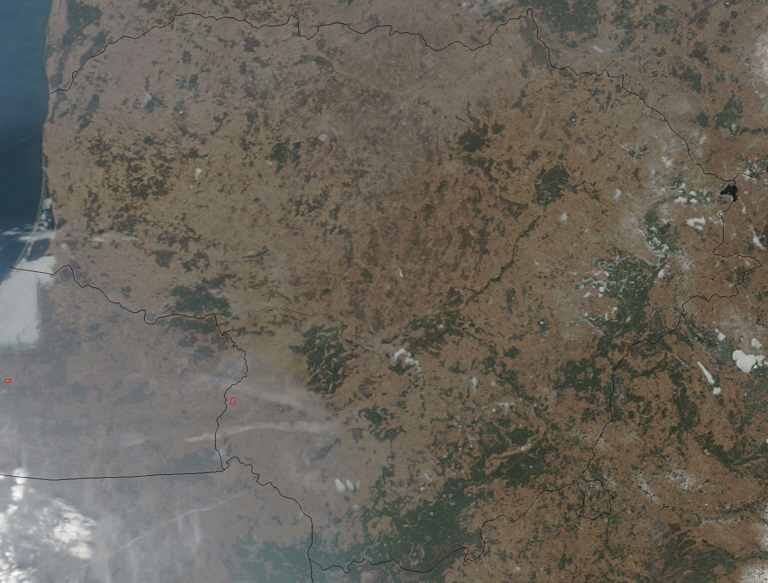
Lithuania is situated on the eastern shore of the Baltic Sea.[2] Lithuania's boundaries have changed several times since 1918, but they have been stable since 1945.[2] Currently, Lithuania covers an area of about 65,300 km2 (25,200 sq mi).[2] It is larger than Belgium, Denmark, Latvia, Estonia, the Netherlands, Slovakia, Slovenia or Switzerland.[2] Lithuania borders Latvia on the north, Belarus on the east and south, and Poland and the Kaliningrad region of Russia on the southwest. The Eastern border together with Latvia in the South of its East comes along with the Krokuva-Vilnius-Veliky Novgorod route with it chiefly within the territory. It is a country of gently rolling hills, many forests, rivers and streams, and lakes. Its principal natural resource is agricultural land.[citation needed]
Lithuania's northern neighbor is Latvia.[2] The two countries share a border that extends 453 kilometres. Lithuania's eastern border with Belarus is longer, stretching 502 kilometers.[2] The border with Poland on the south is relatively short, only 91 kilometers, but it is very busy because of international traffic.[2] Lithuania also has a 227-kilometer border with Russia. Russian territory adjacent to Lithuania is Kaliningrad Oblast, which is the northern part of the former German East Prussia, including the city of Kaliningrad.[2] Finally, Lithuania has 108 kilometers of Baltic seashore with an ice-free harbor at Klaipėda.[2] The Baltic coast offers sandy beaches and pine forests and attracts thousands of vacationers.[2]
According to some geographers, the geographical midpoint of Europe is just north of Lithuania's capital, Vilnius.[3]
Major coordinates
[edit]In terms of latitude or climate fifteen degrees (corresponding to the longitude or an hour fifteen degrees, except the polar climate sums being 7°30´ in latitude) Lithuania situates within the 52°30´-N - 67°30´-N latitude, that is northwards from Southend latitude, together with the North Sea major body, the Far North of Germany, Siberia. It situates in the southern quarter of the climate fifteen degrees, stretching northwards from the southern mark of the climate fifteen degrees further than in nearly one tenth or the sum of <1°30´, that is kind of an edge zone of the climate fifteen degrees, being generally boggy in the western Belarus, and on the 54°-N latitude the one tenth zone is marked by the greatest bog in Lithuania the Čepkeliai Marsh.
With the Eastern Hemisphere core longitude on the 67°30´-E, the hour or its longitude fifteen degrees that set on Lithuania are 15°-E - 30°-E (Greenwich, London) longitude, the core of which coming on the 22°30´-E longitude also marks the western one fourth, or the sum of 45° in the West of the Eastern Hemisphere if marking it with the Cape Verde archipelago and the Transantarctic Mountains. The 22°30´-E longitude comes in the West of Lithuania, with the river Jūra (pronounced as in Euro except the ending vowel) meaning sea locally flowing on the mark. Tilsit (Kaliningrad Oblast), Telšiai as the Greek thalassa situate in the western one fourth of the Eastern Hemisphere, although Talsi (Latvia) situate eastwards from the mark. The rivers Šešupė, Šešuvis, Šušvė plus Šyša situate in the sum of approximately 2°30´ longitude or one sixth of an hour fifteen degrees (šeši - six in Lithuanian), in the both sides of the 22°30´-E mark.
Topography and drainage
[edit]
Lithuania lies at the edge of the North European Plain.[2] Its landscape was shaped by the glaciers of the last Ice Age,[2] which retreated about 25,000–22,000 years BP (Before Present).[citation needed] Lithuania's terrain is an alternation of moderate lowlands and highlands.[2] The highest elevation is 297.84 meters above sea level, found in the eastern part of the republic and separated from the uplands of the western region of Samogitia by the fertile plains of the southwestern and central regions.[2] The landscape is punctuated by 2,833 lakes larger than 1 hectare (2.5 acres) and 1,600 smaller ponds.[2] The majority of the lakes are found in the eastern part of the country.[2] Lithuania also has 758 rivers longer than 10 kilometres (6.2 mi).[2] The largest river is the Nemunas (total length 917 km (570 mi)), which originates in Belarus.[2] The other larger waterways are the Neris (510 km (320 mi)), Venta (346 km (215 mi)), and Šešupė (298 km (185 mi)) rivers.[2] However, only 600 kilometres (370 mi) of Lithuania's rivers are navigable.[2]
Once a heavily forested land, Lithuania's territory today consists of only 32.8 percent[4] woodlands—primarily pine, spruce, and birch forests.[2] Ash and oak are very scarce.[2] The forests are rich in mushrooms and berries,[2] as well as a variety of plants.
Climate
[edit]

Lithuania has a humid continental climate (Dfb in the Köppen climate classification).[5] Average temperatures on the coast are 1.6 °C (34.9 °F) in January and 17.8 °C (64.0 °F) in July.[2] In Vilnius the average temperatures are −3.7 °C (25.3 °F) in January and 18.1 °C (64.6 °F) in July.[2] Simply speaking, 20 °C (68 °F) is frequent on summer days and 14 °C (57.2 °F) at night.[citation needed] Temperatures occasionally reach 30 or 35 °C (86 or 95 °F) in summer.[citation needed] Winters when easterly flows from Siberia predominate, like 1941–42, 1955–56 and 1984–85,[6] are very cold, whereas winters dominated by westerly maritime airflows like 1924–25, 1960–61 and 1988–89 are mild with temperatures above freezing a normal occurrence.[citation needed] −20 °C or −4 °F occurs almost every winter.[citation needed] Winter extremes are −34 °C (−29 °F) at the coast and −43 °C (−45 °F) in the east of Lithuania.[citation needed] The average annual precipitation is 717 millimetres (28.2 in) on the coast,[2] 900 mm (35.4 in) in Samogitia highlands,[citation needed] and 490 mm (19.3 in) in the eastern part of the country.[2] Snow occurs every year, it can be snowing from October to April.[citation needed] In some years sleet can fall in September or May.[citation needed] The growing season lasts 202 days in the western part of the country and 169 days in the eastern part.[2] Severe storms are rare in the eastern part of Lithuania and common nearer the coast.[citation needed]
The longest measured temperature records from the Baltic area cover about 250 years. The data show that there were warm periods during the latter half of the eighteenth century and that the nineteenth century was a relatively cool period. An early twentieth century warming culminated in the 1930s, followed by a smaller cooling that lasted until the 1960s. A warming trend has persisted since then.[7]
Lithuania experienced a drought in 2002, causing forest and peat bog fires.[8] The country suffered along with the rest of Northwestern Europe during a heatwave in the summer of 2006.
Examples
[edit]General averages
[edit]| Climate data for Lithuania (general) | |||||||||||||
|---|---|---|---|---|---|---|---|---|---|---|---|---|---|
| Month | Jan | Feb | Mar | Apr | May | Jun | Jul | Aug | Sep | Oct | Nov | Dec | Year |
| Record high °C (°F) | 14.9 (58.8) |
16.5 (61.7) |
25.5 (77.9) |
31.0 (87.8) |
34.0 (93.2) |
35.7 (96.3) |
37.5 (99.5) |
37.4 (99.3) |
35.1 (95.2) |
26.0 (78.8) |
18.5 (65.3) |
15.6 (60.1) |
37.5 (99.5) |
| Mean daily maximum °C (°F) | −1.7 (28.9) |
−1.3 (29.7) |
2.3 (36.1) |
9.4 (48.9) |
16.5 (61.7) |
19.9 (67.8) |
20.9 (69.6) |
20.6 (69.1) |
15.8 (60.4) |
9.9 (49.8) |
3.5 (38.3) |
−0.1 (31.8) |
9.5 (49.1) |
| Daily mean °C (°F) | −3.9 (25.0) |
−3.5 (25.7) |
−0.1 (31.8) |
5.5 (41.9) |
11.6 (52.9) |
15.2 (59.4) |
16.7 (62.1) |
16.1 (61.0) |
12.2 (54.0) |
7.0 (44.6) |
1.8 (35.2) |
−1.7 (28.9) |
6.2 (43.2) |
| Mean daily minimum °C (°F) | −6.3 (20.7) |
−6.6 (20.1) |
−2.8 (27.0) |
1.5 (34.7) |
7.0 (44.6) |
10.5 (50.9) |
12.2 (54.0) |
11.9 (53.4) |
8.3 (46.9) |
4.0 (39.2) |
0.1 (32.2) |
−3.7 (25.3) |
2.7 (36.9) |
| Record low °C (°F) | −40.6 (−41.1) |
−42.9 (−45.2) |
−37.5 (−35.5) |
−23.0 (−9.4) |
−6.8 (19.8) |
−2.8 (27.0) |
0.9 (33.6) |
−2.9 (26.8) |
−6.3 (20.7) |
−19.5 (−3.1) |
−23.0 (−9.4) |
−34.0 (−29.2) |
−42.9 (−45.2) |
| Average precipitation mm (inches) | 36.2 (1.43) |
30.1 (1.19) |
33.9 (1.33) |
42.9 (1.69) |
52.0 (2.05) |
69.0 (2.72) |
76.9 (3.03) |
77.0 (3.03) |
60.3 (2.37) |
49.9 (1.96) |
50.4 (1.98) |
47.0 (1.85) |
625.5 (24.63) |
| Source 1: Records of Lithuanian climate[9][10] | |||||||||||||
| Source 2: Weatherbase[11] | |||||||||||||
Cities
[edit]| Climate data for Vilnius (1991–2020 normals, sun 1961–1990, extremes 1777-present) | |||||||||||||
|---|---|---|---|---|---|---|---|---|---|---|---|---|---|
| Month | Jan | Feb | Mar | Apr | May | Jun | Jul | Aug | Sep | Oct | Nov | Dec | Year |
| Record high °C (°F) | 11.0 (51.8) |
14.4 (57.9) |
20.0 (68.0) |
29.0 (84.2) |
31.8 (89.2) |
34.2 (93.6) |
36.5 (97.7) |
34.9 (94.8) |
33.1 (91.6) |
24.5 (76.1) |
15.5 (59.9) |
10.5 (50.9) |
36.5 (97.7) |
| Mean maximum °C (°F) | 4.9 (40.8) |
5.7 (42.3) |
13.1 (55.6) |
22.4 (72.3) |
26.7 (80.1) |
28.8 (83.8) |
30.8 (87.4) |
30.3 (86.5) |
25.4 (77.7) |
18.3 (64.9) |
11.1 (52.0) |
6.1 (43.0) |
32.1 (89.8) |
| Mean daily maximum °C (°F) | −1.7 (28.9) |
−0.5 (31.1) |
4.4 (39.9) |
12.6 (54.7) |
18.4 (65.1) |
21.7 (71.1) |
23.8 (74.8) |
23.1 (73.6) |
17.4 (63.3) |
10.2 (50.4) |
3.7 (38.7) |
−0.3 (31.5) |
11.2 (52.2) |
| Daily mean °C (°F) | −3.9 (25.0) |
−3.1 (26.4) |
0.9 (33.6) |
7.6 (45.7) |
13.0 (55.4) |
16.4 (61.5) |
18.7 (65.7) |
17.9 (64.2) |
13.0 (55.4) |
7.0 (44.6) |
1.8 (35.2) |
−2.2 (28.0) |
7.3 (45.1) |
| Mean daily minimum °C (°F) | −5.9 (21.4) |
−5.6 (21.9) |
−2.7 (27.1) |
2.6 (36.7) |
7.5 (45.5) |
11.1 (52.0) |
13.6 (56.5) |
12.7 (54.9) |
8.5 (47.3) |
3.7 (38.7) |
−0.1 (31.8) |
−4.1 (24.6) |
3.5 (38.3) |
| Mean minimum °C (°F) | −19.3 (−2.7) |
−17.5 (0.5) |
−10.8 (12.6) |
−4.2 (24.4) |
0.1 (32.2) |
4.9 (40.8) |
8.1 (46.6) |
6.8 (44.2) |
1.1 (34.0) |
−3.8 (25.2) |
−8.7 (16.3) |
−14.1 (6.6) |
−22.0 (−7.6) |
| Record low °C (°F) | −37.2 (−35.0) |
−35.8 (−32.4) |
−29.6 (−21.3) |
−14.4 (6.1) |
−4.4 (24.1) |
0.1 (32.2) |
3.5 (38.3) |
1.0 (33.8) |
−4.8 (23.4) |
−14.4 (6.1) |
−22.8 (−9.0) |
−30.5 (−22.9) |
−37.2 (−35.0) |
| Average precipitation mm (inches) | 38.9 (1.53) |
34.4 (1.35) |
37.0 (1.46) |
46.2 (1.82) |
52.1 (2.05) |
72.7 (2.86) |
79.3 (3.12) |
75.8 (2.98) |
65.2 (2.57) |
51.5 (2.03) |
51.5 (2.03) |
49.2 (1.94) |
653.8 (25.74) |
| Average precipitation days | 21.7 | 18.4 | 17.5 | 10.2 | 12.4 | 11.7 | 11.4 | 10.5 | 9.7 | 13.5 | 16.7 | 21.2 | 174.9 |
| Mean monthly sunshine hours | 37 | 70 | 117 | 165 | 242 | 231 | 220 | 217 | 141 | 93 | 33 | 25 | 1,591 |
| Average ultraviolet index | 0 | 1 | 2 | 3 | 5 | 6 | 6 | 5 | 3 | 2 | 1 | 0 | 3 |
| Source: WMO (avg high and low)[12] NOAA (sun, extremes, and mean temperatures),[13] Météo Climat[14] and Weather Atlas[15] | |||||||||||||
| Climate data for Kaunas (1991-2020 normals, extremes 1901-present) | |||||||||||||
|---|---|---|---|---|---|---|---|---|---|---|---|---|---|
| Month | Jan | Feb | Mar | Apr | May | Jun | Jul | Aug | Sep | Oct | Nov | Dec | Year |
| Record high °C (°F) | 11.7 (53.1) |
14.8 (58.6) |
23.3 (73.9) |
28.6 (83.5) |
31.4 (88.5) |
32.9 (91.2) |
34.9 (94.8) |
35.3 (95.5) |
33.3 (91.9) |
23.9 (75.0) |
16.7 (62.1) |
11.1 (52.0) |
35.3 (95.5) |
| Mean maximum °C (°F) | 5.8 (42.4) |
6.3 (43.3) |
12.8 (55.0) |
22.5 (72.5) |
26.5 (79.7) |
28.2 (82.8) |
30.7 (87.3) |
30.5 (86.9) |
25.3 (77.5) |
18.3 (64.9) |
11.4 (52.5) |
6.7 (44.1) |
32.0 (89.6) |
| Mean daily maximum °C (°F) | −0.8 (30.6) |
0.2 (32.4) |
4.8 (40.6) |
12.9 (55.2) |
18.6 (65.5) |
21.6 (70.9) |
24.0 (75.2) |
23.3 (73.9) |
17.9 (64.2) |
11.0 (51.8) |
4.6 (40.3) |
0.8 (33.4) |
11.8 (53.2) |
| Daily mean °C (°F) | −3.0 (26.6) |
−2.6 (27.3) |
1.3 (34.3) |
7.9 (46.2) |
13.0 (55.4) |
16.3 (61.3) |
18.7 (65.7) |
18.1 (64.6) |
13.3 (55.9) |
7.5 (45.5) |
2.6 (36.7) |
−1.4 (29.5) |
7.9 (46.2) |
| Mean daily minimum °C (°F) | −5.4 (22.3) |
−5.2 (22.6) |
−2.2 (28.0) |
2.7 (36.9) |
7.3 (45.1) |
10.9 (51.6) |
13.3 (55.9) |
12.6 (54.7) |
8.7 (47.7) |
4.1 (39.4) |
0.6 (33.1) |
−3.1 (26.4) |
3.8 (38.8) |
| Mean minimum °C (°F) | −18.2 (−0.8) |
−16.2 (2.8) |
−9.9 (14.2) |
−3.4 (25.9) |
0.6 (33.1) |
5.0 (41.0) |
8.3 (46.9) |
7.0 (44.6) |
1.5 (34.7) |
−2.9 (26.8) |
−7.0 (19.4) |
−12.2 (10.0) |
−21.3 (−6.3) |
| Record low °C (°F) | −35.8 (−32.4) |
−36.3 (−33.3) |
−26.3 (−15.3) |
−12.0 (10.4) |
−3.7 (25.3) |
0.1 (32.2) |
2.1 (35.8) |
0.3 (32.5) |
−3.0 (26.6) |
−13.7 (7.3) |
−21.0 (−5.8) |
−30.6 (−23.1) |
−36.3 (−33.3) |
| Average precipitation mm (inches) | 53.0 (2.09) |
41.4 (1.63) |
44.0 (1.73) |
42.0 (1.65) |
57.5 (2.26) |
71.8 (2.83) |
95.8 (3.77) |
84.2 (3.31) |
56.1 (2.21) |
69.2 (2.72) |
50.2 (1.98) |
48.2 (1.90) |
710.2 (27.96) |
| Average precipitation days | 12.29 | 10.77 | 10.40 | 8.50 | 9.25 | 10.76 | 10.72 | 10.51 | 8.46 | 10.76 | 10.65 | 11.21 | 124.53 |
| Mean monthly sunshine hours | 40.3 | 67.8 | 127.1 | 174.0 | 251.1 | 264.0 | 257.3 | 238.7 | 159.0 | 99.2 | 42.0 | 27.9 | 1,748.4 |
| Source 1: World Meteorological Organization[16] NOAA (extremes)[17] | |||||||||||||
| Source 2: Hong Kong Observatory (sun only)[18] Météo Climat (normal temps & precipitation)[19] | |||||||||||||
| Climate data for Klaipėda (1991-2020 normals, extremes 1929-present) | |||||||||||||
|---|---|---|---|---|---|---|---|---|---|---|---|---|---|
| Month | Jan | Feb | Mar | Apr | May | Jun | Jul | Aug | Sep | Oct | Nov | Dec | Year |
| Record high °C (°F) | 11.7 (53.1) |
15.4 (59.7) |
18.6 (65.5) |
28.9 (84.0) |
31.2 (88.2) |
33.8 (92.8) |
34.0 (93.2) |
36.6 (97.9) |
30.4 (86.7) |
22.9 (73.2) |
15.4 (59.7) |
11.5 (52.7) |
36.6 (97.9) |
| Mean maximum °C (°F) | 6.1 (43.0) |
5.7 (42.3) |
10.6 (51.1) |
21.0 (69.8) |
26.2 (79.2) |
27.6 (81.7) |
30.0 (86.0) |
29.2 (84.6) |
23.9 (75.0) |
17.5 (63.5) |
11.1 (52.0) |
7.5 (45.5) |
31.3 (88.3) |
| Mean daily maximum °C (°F) | 1.3 (34.3) |
1.3 (34.3) |
4.5 (40.1) |
10.8 (51.4) |
16.0 (60.8) |
19.3 (66.7) |
22.1 (71.8) |
22.3 (72.1) |
17.8 (64.0) |
11.9 (53.4) |
6.3 (43.3) |
3.2 (37.8) |
11.6 (52.9) |
| Daily mean °C (°F) | −0.7 (30.7) |
−0.9 (30.4) |
1.8 (35.2) |
7.1 (44.8) |
11.8 (53.2) |
15.5 (59.9) |
18.4 (65.1) |
18.5 (65.3) |
14.3 (57.7) |
9.0 (48.2) |
4.2 (39.6) |
1.2 (34.2) |
8.5 (47.3) |
| Mean daily minimum °C (°F) | −2.9 (26.8) |
−3.1 (26.4) |
−1.0 (30.2) |
3.1 (37.6) |
7.5 (45.5) |
11.6 (52.9) |
14.7 (58.5) |
14.6 (58.3) |
10.8 (51.4) |
6.2 (43.2) |
2.3 (36.1) |
−0.8 (30.6) |
5.3 (41.5) |
| Mean minimum °C (°F) | −13.5 (7.7) |
−12.0 (10.4) |
−7.5 (18.5) |
−2.6 (27.3) |
0.6 (33.1) |
5.9 (42.6) |
9.4 (48.9) |
9.4 (48.9) |
3.8 (38.8) |
−1.4 (29.5) |
−5.1 (22.8) |
−9.0 (15.8) |
−16.4 (2.5) |
| Record low °C (°F) | −32.0 (−25.6) |
−33.4 (−28.1) |
−20.8 (−5.4) |
−12.8 (9.0) |
−5.2 (22.6) |
−2.8 (27.0) |
5.2 (41.4) |
2.9 (37.2) |
−3.3 (26.1) |
−7.5 (18.5) |
−14.6 (5.7) |
−24.1 (−11.4) |
−33.4 (−28.1) |
| Average precipitation mm (inches) | 73.4 (2.89) |
50.7 (2.00) |
47.1 (1.85) |
36.2 (1.43) |
43.7 (1.72) |
59.7 (2.35) |
74.1 (2.92) |
96.8 (3.81) |
89.5 (3.52) |
108.3 (4.26) |
90.1 (3.55) |
79.9 (3.15) |
853.1 (33.59) |
| Average precipitation days | 14.77 | 11.35 | 10.05 | 7.45 | 7.59 | 9.22 | 9.42 | 11.67 | 11.55 | 14.86 | 14.49 | 15.39 | 138.72 |
| Mean monthly sunshine hours | 34 | 65 | 122 | 180 | 264 | 285 | 274 | 252 | 167 | 100 | 40 | 28 | 1,811 |
| Source 1: Météo Climat[20] | |||||||||||||
| Source 2: NOAA[21] | |||||||||||||
| Climate data for Šiauliai (1991–2020 normals, extremes 1937-present) | |||||||||||||
|---|---|---|---|---|---|---|---|---|---|---|---|---|---|
| Month | Jan | Feb | Mar | Apr | May | Jun | Jul | Aug | Sep | Oct | Nov | Dec | Year |
| Record high °C (°F) | 10.5 (50.9) |
13.3 (55.9) |
21.0 (69.8) |
26.6 (79.9) |
30.4 (86.7) |
32.1 (89.8) |
35.0 (95.0) |
35.7 (96.3) |
30.1 (86.2) |
23.3 (73.9) |
16.9 (62.4) |
13.4 (56.1) |
35.7 (96.3) |
| Mean maximum °C (°F) | 5.9 (42.6) |
6.2 (43.2) |
12.9 (55.2) |
21.9 (71.4) |
26.3 (79.3) |
28.2 (82.8) |
30.2 (86.4) |
29.6 (85.3) |
24.1 (75.4) |
17.7 (63.9) |
10.9 (51.6) |
6.6 (43.9) |
31.4 (88.5) |
| Mean daily maximum °C (°F) | −0.4 (31.3) |
−0.1 (31.8) |
4.7 (40.5) |
12.4 (54.3) |
17.9 (64.2) |
21.2 (70.2) |
23.6 (74.5) |
22.9 (73.2) |
17.3 (63.1) |
10.7 (51.3) |
4.5 (40.1) |
0.8 (33.4) |
11.4 (52.5) |
| Daily mean °C (°F) | −2.5 (27.5) |
−2.9 (26.8) |
1.1 (34.0) |
7.4 (45.3) |
12.4 (54.3) |
16.0 (60.8) |
18.5 (65.3) |
17.9 (64.2) |
13.0 (55.4) |
7.6 (45.7) |
2.4 (36.3) |
−1.2 (29.8) |
7.6 (45.7) |
| Mean daily minimum °C (°F) | −4.9 (23.2) |
−5.7 (21.7) |
−2.5 (27.5) |
2.3 (36.1) |
6.8 (44.2) |
10.8 (51.4) |
13.4 (56.1) |
12.8 (55.0) |
8.7 (47.7) |
4.3 (39.7) |
0.4 (32.7) |
−3.2 (26.2) |
3.6 (38.5) |
| Mean minimum °C (°F) | −17.3 (0.9) |
−17.2 (1.0) |
−11.0 (12.2) |
−3.7 (25.3) |
0.1 (32.2) |
4.9 (40.8) |
8.5 (47.3) |
7.2 (45.0) |
1.6 (34.9) |
−3.0 (26.6) |
−7.2 (19.0) |
−12.7 (9.1) |
−21.3 (−6.3) |
| Record low °C (°F) | −36.0 (−32.8) |
−36.4 (−33.5) |
−27.0 (−16.6) |
−13.2 (8.2) |
−3.5 (25.7) |
0.1 (32.2) |
5.2 (41.4) |
2.1 (35.8) |
−5.7 (21.7) |
−8.5 (16.7) |
−19.3 (−2.7) |
−31.1 (−24.0) |
−36.4 (−33.5) |
| Average precipitation mm (inches) | 44.2 (1.74) |
35.1 (1.38) |
36.3 (1.43) |
33.4 (1.31) |
54.4 (2.14) |
71.0 (2.80) |
77.5 (3.05) |
68.8 (2.71) |
53.8 (2.12) |
71.9 (2.83) |
52.3 (2.06) |
45.4 (1.79) |
642.7 (25.30) |
| Average precipitation days | 11.32 | 9.86 | 9.45 | 7.12 | 8.65 | 10.04 | 10.12 | 10.36 | 9.07 | 12.17 | 11.25 | 11.91 | 121.50 |
| Mean monthly sunshine hours | 37 | 65 | 125 | 176 | 263 | 277 | 261 | 243 | 166 | 100 | 42 | 29 | 1,784 |
| Source 1: Météo Climat[22] | |||||||||||||
| Source 2: NOAA (extremes and sun)[23] | |||||||||||||
| Climate data for Panevėžys (1991−2020 normals, extremes 1959−present) | |||||||||||||
|---|---|---|---|---|---|---|---|---|---|---|---|---|---|
| Month | Jan | Feb | Mar | Apr | May | Jun | Jul | Aug | Sep | Oct | Nov | Dec | Year |
| Record high °C (°F) | 11.8 (53.2) |
10.6 (51.1) |
18.1 (64.6) |
26.6 (79.9) |
29.5 (85.1) |
32.5 (90.5) |
35.3 (95.5) |
34.0 (93.2) |
28.4 (83.1) |
21.7 (71.1) |
13.6 (56.5) |
10.3 (50.5) |
35.3 (95.5) |
| Mean daily maximum °C (°F) | −0.3 (31.5) |
1.5 (34.7) |
4.3 (39.7) |
12.4 (54.3) |
17.0 (62.6) |
21.5 (70.7) |
23.8 (74.8) |
22.9 (73.2) |
17.5 (63.5) |
11.3 (52.3) |
4.0 (39.2) |
−0.3 (31.5) |
11.3 (52.3) |
| Daily mean °C (°F) | −2.5 (27.5) |
−1.3 (29.7) |
0.8 (33.4) |
7.7 (45.9) |
11.5 (52.7) |
16.4 (61.5) |
18.3 (64.9) |
17.3 (63.1) |
12.7 (54.9) |
8.0 (46.4) |
1.9 (35.4) |
−2.4 (27.7) |
7.4 (45.3) |
| Mean daily minimum °C (°F) | −4.7 (23.5) |
−4.0 (24.8) |
−2.6 (27.3) |
2.9 (37.2) |
6.0 (42.8) |
11.3 (52.3) |
12.8 (55.0) |
11.7 (53.1) |
7.9 (46.2) |
4.6 (40.3) |
−0.3 (31.5) |
−4.5 (23.9) |
3.4 (38.2) |
| Record low °C (°F) | −27.4 (−17.3) |
−27.7 (−17.9) |
−17.0 (1.4) |
−6.5 (20.3) |
−2.5 (27.5) |
1.9 (35.4) |
5.8 (42.4) |
0.0 (32.0) |
−3.8 (25.2) |
−8.0 (17.6) |
−21.5 (−6.7) |
−30.3 (−22.5) |
−30.3 (−22.5) |
| Average precipitation mm (inches) | 49.8 (1.96) |
33.8 (1.33) |
36.6 (1.44) |
43.1 (1.70) |
64.8 (2.55) |
67.5 (2.66) |
103.1 (4.06) |
54.2 (2.13) |
40.5 (1.59) |
56.3 (2.22) |
44.6 (1.76) |
40.4 (1.59) |
634.7 (24.99) |
| Average precipitation days (≥ 1 mm) | 11.1 | 11.9 | 10.1 | 8.3 | 9.1 | 10.8 | 9.7 | 10.4 | 7.8 | 11.0 | 11.2 | 11.1 | 122.5 |
| Source: NOAA[24] | |||||||||||||
| Climate data for Alytus | |||||||||||||
|---|---|---|---|---|---|---|---|---|---|---|---|---|---|
| Month | Jan | Feb | Mar | Apr | May | Jun | Jul | Aug | Sep | Oct | Nov | Dec | Year |
| Mean daily maximum °C (°F) | −2.2 (28.0) |
−1.1 (30.0) |
3.9 (39.0) |
11.1 (52.0) |
18.3 (64.9) |
21.1 (70.0) |
22.2 (72.0) |
22.2 (72.0) |
16.7 (62.1) |
11.1 (52.0) |
4.4 (39.9) |
−0.6 (30.9) |
10.6 (51.1) |
| Daily mean °C (°F) | −5.0 (23.0) |
−4.4 (24.1) |
0.0 (32.0) |
6.1 (43.0) |
12.2 (54.0) |
15.6 (60.1) |
16.7 (62.1) |
16.7 (62.1) |
12.2 (54.0) |
7.2 (45.0) |
2.2 (36.0) |
−2.8 (27.0) |
6.4 (43.5) |
| Mean daily minimum °C (°F) | −7.8 (18.0) |
−7.8 (18.0) |
−3.9 (25.0) |
1.1 (34.0) |
6.1 (43.0) |
10.0 (50.0) |
11.7 (53.1) |
10.6 (51.1) |
7.2 (45.0) |
3.3 (37.9) |
0.0 (32.0) |
−5.0 (23.0) |
2.1 (35.8) |
| Average rainfall mm (inches) | 41 (1.6) |
27 (1.1) |
36 (1.4) |
41 (1.6) |
56 (2.2) |
74 (2.9) |
80 (3.1) |
70 (2.8) |
60 (2.4) |
48 (1.9) |
51 (2.0) |
50 (2.0) |
634 (25.0) |
| Average precipitation days | 8 | 9 | 14 | 16 | 16 | 12 | 13 | 14 | 12 | 14 | 8 | 7 | 143 |
| Source: [25] | |||||||||||||
Environment
[edit]Concerned with environmental deterioration, Lithuanian governments have created several national parks and reservations.[2] The country's flora and fauna have suffered, however, from an almost fanatical drainage of land for agricultural use.[2] Environmental problems of a different nature were created by the development of environmentally unsafe industries.[2] Air pollution problems exist mainly in the cities, such as Vilnius, Kaunas, Jonava, Mažeikiai, Elektrėnai, and Naujoji Akmenė—the sites of fertilizer and other chemical plants, an oil refinery, power station, and a cement factory.[2]
Water quality has also been an issue.[2] The city of Kaunas, with a population of about 400,000, had no water purification plant until 1999; sewage was sent directly into the Neman River. Tertiary wastewater treatment is scheduled to come on-line in 2007.[26] River and lake pollution are other legacies of Soviet carelessness with the environment. The Courland Lagoon, for example, separated from the Baltic Sea by a strip of high dunes and pine forests, is about 85 percent contaminated.[2] Beaches in the Baltic resorts, such as the well-known vacation area of Palanga, are frequently closed for swimming because of contamination.[2] Forests affected by acid rain are found in the vicinity of Jonava, Mažeikiai, and Elektrėnai, which are the chemical, oil, and power-generation centers.[2] Lithuania was among the first former Soviet republics to introduce environmental regulations.[2] However, because of Moscow's emphasis on increasing production and because of numerous local violations, technological backwardness, and political apathy, serious environmental problems now exist.[2]
Natural hazards: hurricane-force storms, blizzards, droughts, floods
Environment—current issues: contamination of soil and groundwater with petroleum products and chemicals at former Soviet military bases
Environment—international agreements:
- party to:
Air Pollution, Air Pollution-Nitrogen Oxides, Air Pollution-Persistent Organic Pollutants, Air Pollution-Sulphur 85, Air Pollution-Sulphur 94, Air Pollution-Volatile Organic Compounds, Biodiversity, Climate Change, Climate Change-Kyoto Protocol, Desertification, Endangered Species, Environmental Modification, Hazardous Wastes, Law of the Sea, Ozone Layer Protection, Ship Pollution, Wetlands
- signed, but not ratified:
Natural resources
[edit]

Lithuania has an abundance of limestone, clay, quartz sand, gypsum sand, and dolomite, which are suitable for making high-quality cement, glass, and ceramics.[2] There also is an ample supply of mineral water, but energy sources and industrial materials are all in short supply.[2] Oil was discovered in Lithuania in the 1950s, but only a few wells operate, and all that do are located in the western part of the country.[2] It is estimated that the Baltic Sea shelf and the western region of Lithuania hold commercially viable amounts of oil, but if exploited this oil would satisfy only about 20 percent of Lithuania's annual need for petroleum products for the next twenty years.[2] Lithuania has a large amount of thermal energy along the Baltic Sea coast which could be used to heat hundreds of thousands of homes, as is done in Iceland.[2] In addition, iron ore deposits have been found in the southern region of Lithuania.[2] But commercial exploitation of these deposits probably would require strip mining, which is environmentally unsound.[2] Moreover, exploitation of these resources will depend on Lithuania's ability to attract capital and technology from abroad.[2]
Lithuania and Denmark are the only countries in Europe, which are fully equipped with fresh groundwater. The Lithuanians consume about 0.5 million cubic metres of water per day, which is only 12–14 percent of all explored fresh groundwater resources.[27] Water quality in the country is very high and is determined by the fact that drinking water comes from deep layers that are protected from pollution on the surface of the earth. Drilling depth usually reaches 30–50 metres, but in Klaipėda Region it even reaches 250 metres. Consequently, Lithuania is one of very few European countries where groundwater is used for centralized water supply. With a large underground fresh water reserves, Lithuania exports mineral-rich water to other countries. Approved mineral water quantity is about 2.7 million cubic metres per year, while production is only 4–5 percent of all mineral water resources.[28]
Lithuania's capital Vilnius is the only Baltic capital city that uses centralized water supplying from deep water springs, which are protected from pollution and has no nitrates or nitrites that are harmful to the human body. Water is cleaned without chemicals in Lithuania. About 20% of the consumed water in the state is a non-filtered very high quality water.[29]
Natural resources: peat, arable land, amber.
Land use:
- arable land: 33.48%
- permanent crops: 0.47%
- other: 66.05% (2011)
Irrigated land: 13.4 km2 (2011)
Total renewable water resources: 24.9 km3 (2011)
Area and boundaries
[edit]
.png)
Area:
- Total: 65,300 km2
- Land: 62,680 km2
- Water: 2,620 km2
Comparative area
- Australia comparative: slightly smaller (5.5%) than Tasmania
- Canada comparative: about 9% smaller than New Brunswick
- United Kingdom comparative: about 17% smaller than Scotland
- United States comparative: slightly larger (4%) than West Virginia
Land boundaries:
- Total: 1,574 km
- Border countries: Belarus 680 km, Latvia 576 km, Poland 91 km, Russia (Kaliningrad) 227 km
Coastline: 262 km (163 mi).[30] The coastline consists of 20 kilometres from Klaipėda, 50 kilometres at Cape Nehrung, and 21 kilometres in the region of Palanga and the mouth of the Šventoji river.[31] Lithuania Minor occupies two-thirds of the Lithuanian coast-line.
Maritime claims:
- Territorial sea: 12 nmi (22.2 km; 13.8 mi)
- Exclusive Economic Zone: 7,031 km2 (2,715 sq mi) with 12 nmi (22.2 km; 13.8 mi)
Latitude and longitude
[edit]- Northern point: near former Lemkinė village on the shores of Nemunėlis in the Biržai district municipality[32] 56°27′1″N 24°53′05″E / 56.45028°N 24.88472°E
- Southern point: in the Varėna district municipality, in uninhabitable forest area, cadastrally belonging to village Musteika.[33] 53°53′48″N 24°21′07″E / 53.89667°N 24.35194°E The southernmost habitable place is in the village Ašašninkai, so called fraction Plaskiniškės.[34]53°55′51″N 24°17′14″E / 53.93083°N 24.28722°E
- Eastern point: near Vosiūnai village in the Ignalina district municipality[33] 55°17′08″N 26°50′08″E / 55.28556°N 26.83556°E
- Western point: Nida 55°16′51″N 20°57′18″E / 55.28083°N 20.95500°E
Elevation extremes:
- Lowest point: Baltic Sea 0 m
- Highest point: Aukštojas Hill 294 metres (965 ft)
See also
[edit]References
[edit]![]() This article incorporates public domain material from "Lithuania". The World Factbook. CIA.
This article incorporates public domain material from "Lithuania". The World Factbook. CIA.
- ^ "Country overview and assessment The economics of climate change adaptation in EU coastal areas- Lithuania" (PDF). ec.europa.eu/maritimeaffairs/. European Commission Policy Research Corporation. pp. 1, 2. Archived (PDF) from the original on 5 March 2016. Retrieved 6 August 2015.
- ^ a b c d e f g h i j k l m n o p q r s t u v w x y z aa ab ac ad ae af ag ah ai aj ak al am an ao ap aq ar as at
 This article incorporates text from this source, which is in the public domain: Vardys, V. Stanley; Sloven, William A. (1996). "Lithuania: Physical Environment". In Iwaskiw, Walter R. (ed.). Estonia, Latvia & Lithuania: country studies (1st ed.). Washington, D.C.: Federal Research Division, Library of Congress. pp. 186–189. ISBN 0-8444-0851-4. OCLC 34245562. Archived from the original on 2021-06-24. Retrieved 2021-06-04.
- ^ "Centre of Europe". Atlas Obscura. Archived from the original on 2022-09-25. Retrieved 2022-09-25.
- ^ http://www.kontrastai.lt/?p=15825[permanent dead link]
- ^ Beck, Hylke E.; McVicar, Tim R.; Vergopolan, Noemi; Berg, Alexis; Lutsko, Nicholas J.; Dufour, Ambroise; Zeng, Zhenzhong; Jiang, Xin; van Dijk, Albert I. J. M.; Miralles, Diego G. (2023-10-23). "High-resolution (1 km) Köppen-Geiger maps for 1901–2099 based on constrained CMIP6 projections". Scientific Data. 10 (1): 724. Bibcode:2023NatSD..10..724B. doi:10.1038/s41597-023-02549-6. ISSN 2052-4463. PMC 10593765. PMID 37872197.
- ^ J.-M. Hirschi, Joël and Sinha, Bablu; ‘Negative NAO and cold Eurasian winters: How exceptional was the winter of 1962/1963?’; Weather Vol. 62, No. 2 (February 2007); pp. 43–48
- ^ "Climate trends in the Baltic" (PDF).[permanent dead link]
- ^ Sakalauskiene, G.; Ignatavicius, G. (2003). "Research Note Effect of drought and fires on the quality of water in Lithuanian". Hydrology and Earth System Sciences. 7 (3): 423. Bibcode:2003HESS....7..423S. doi:10.5194/hess-7-423-2003. S2CID 129291840.
- ^ "Ekstremalūs reiškiniai (Extreme Phenomena)". Meteo.lt. Archived from the original on 1 April 2015. Retrieved 13 April 2015.
- ^ "Rekordiškai šilta Rugsėjo Pirmoji (Warmest 1 September on record)". Meteo.lt. 2 September 2015. Archived from the original on 7 September 2015. Retrieved 7 September 2015.
- ^ "Lithuania Travel Weather Averages (Weatherbase)". Weatherbase. Archived from the original on 2021-05-17. Retrieved 2021-10-09.
- ^ "World Weather Information Service – Vilnius". World Meteorological Organization. Archived from the original on 23 December 2019. Retrieved 2 February 2013.
- ^ "Vilnius Climate Normals 1961–1990". National Oceanic and Atmospheric Administration. Archived from the original on 18 March 2022. Retrieved 2 February 2017.
- ^ "Météo Climat 1991–2020 averages for Lithuania". Météo Climat. Archived from the original on 20 June 2022. Retrieved 2 December 2020.
- ^ "Vilnius, Lithuania - Detailed climate information and monthly weather forecast". Weather Atlas. Yu Media Group. Archived from the original on 2022-06-20. Retrieved 2021-04-06.
- ^ "World Weather Information Service – Kaunas". World Meteorological Organization. May 2011. Archived from the original on 15 January 2018. Retrieved 1 December 2008.
- ^ "Kaunas Climate Normals 1961–1990". National Oceanic and Atmospheric Administration (FTP). Retrieved 2 February 2013.[dead ftp link] (To view documents see Help:FTP)
- ^ "Climatological Normals of Kaunas". Hong Kong Observatory. Archived from the original on 25 October 2019. Retrieved 14 March 2011.
- ^ "Météo Climat stats for Kaunas 1991–2020". Météo Climat. Archived from the original on 20 June 2022. Retrieved 15 October 2017.
- ^ "Météo Climat stats for Klaipėda". Météo Climat. Archived from the original on 20 June 2022. Retrieved 17 October 2017.
- ^ "Klaipėda Climate Normals 1961–1990". National Oceanic and Atmospheric Administration. Archived from the original on 8 April 2023. Retrieved 2 February 2013.
- ^ "Météo Climat stats for Siauliai". Météo Climat. Archived from the original on June 20, 2022. Retrieved October 17, 2017.
- ^ "Siauliai Climate Normals 1961–1990". National Oceanic and Atmospheric Administration. Retrieved March 22, 2015.[permanent dead link]
- ^ "Global Surface Summary of the Day - GSOD". National Oceanic and Atmospheric Administration. Archived from the original on 2023-03-27. Retrieved 27 March 2023.
- ^ "Alytus, Lithuania Temperature Averages". weatherbase.com. Weatherbase. Archived from the original on 6 July 2018. Retrieved 17 June 2015.
- ^ "Wastewater treatment in Kaunas". Archived from the original on 2016-03-03. Retrieved 2006-12-03.
- ^ "Gėlo vandens ištekliais Lietuva išsiskiria iš kitų Europos šalių". LRT (in Lithuanian). 25 May 2016. Archived from the original on 30 April 2021. Retrieved 25 May 2016.
- ^ "Gėlas vanduo – milžiniškas turtas Lietuvos gelmėse". alkas.lt (in Lithuanian). 15 March 2012. Archived from the original on 27 June 2021. Retrieved 15 March 2012.
- ^ Raudonis, Jokūbas (8 May 2013). "Vilniaus turtas – švarus vanduo iš giluminių šaltinių". lrytas.lt (in Lithuanian). Archived from the original on 8 March 2021. Retrieved 8 May 2013.
- ^ "Lithuania – overview" (PDF). European Commission. Archived (PDF) from the original on 2022-07-03. Retrieved 2022-07-09.
- ^ Harrison, Ernest John (1928). Lithuania, 1928. London: Hazell, Watson & Viney. p. 16.
In addition, Lithuania, including the Memel (Klaipéda) region, possesses 91 kilometres of coast-line, i.e. 20 kilometres from Klaipéda (Memel), 50 kilometres at Cape Nehrung, and 21 kilometres of sea-coast in the region of Palanga and the mouth of the Šventoji (Sventa) river.
- ^ Iš Lietuvos geografijos abėcėlės Archived 2009-02-08 at the Wayback Machine
- ^ a b "Tolimiausi Lietuvos taškai". www.angelfire.com. Retrieved 2024-10-25.
- ^ Gudavičius, Henrikas (2018). Klaidžioja kažkas prie Krūčiaus (in Lithuanian). Vilnius: Aštuntoji diena. pp. 471–472.
External links
[edit]- Kursiu Nerija National Park Archived 2016-03-03 at the Wayback Machine
Geography of Lithuania
View on GrokipediaLocation and Geopolitical Context
Coordinates and Spatial Extent
Lithuania occupies a position in northeastern Europe along the southeastern coast of the Baltic Sea, with a 99-kilometer coastline primarily featuring the Curonian Spit and Klaipėda port area.[1] Its land borders total 1,797 kilometers, shared with Latvia (588 km) to the north, Belarus (679 km) to the east and southeast, Poland (104 km) to the southwest, and Russia's Kaliningrad Oblast (286 km) to the west.[1] This configuration places Lithuania as the southernmost of the three Baltic states, influencing its role in regional maritime access and overland trade routes between Scandinavia, Central Europe, and the former Soviet space. The nation's geographic coordinates span latitudes 53°54' N to 56°27' N and longitudes 20°56' E to 26°51' E, encompassing a compact, irregularly rectangular territory oriented northwest-southeast.[7] The approximate geographic center lies near 55°10' N, 24°00' E, close to Vilnius, the capital. Extreme points include the northernmost at 56°27'01" N near the Latvia border in Biržai District, the southernmost at 53°55'51" N in Lazdijai Municipality, the easternmost at 55°17'08" N in Varėna District bordering Belarus, and the westernmost at about 21°00' E on the Curonian Spit. These bounds reflect glacial shaping from the last Ice Age, resulting in minimal topographic extremes and a predominantly low-relief landscape. Lithuania's total area measures 65,300 square kilometers, including 62,680 square kilometers of land and 2,620 square kilometers of inland water bodies such as lakes and rivers.[1] The maximum north-south dimension reaches 276 kilometers, while the east-west span extends 373 kilometers, yielding an elongated form with a length-to-width ratio favoring longitudinal connectivity over latitudinal breadth. This spatial extent positions Lithuania comparably in size to West Virginia or Ireland, with internal divisions into 10 counties facilitating administrative coverage of its modest scale.Borders and Strategic Features
Lithuania's land borders total 1,545 kilometers, shared with four neighboring states: Latvia to the north for 544 kilometers, Belarus to the east and southeast for 640 kilometers, Poland to the southwest for 100 kilometers, and Russia's Kaliningrad Oblast exclave to the southwest for 261 kilometers.[1] These demarcations, largely defined by post-World War II agreements and subsequent treaties, traverse varied terrain including rivers like the Neman (which forms parts of the Belarusian and Polish segments), forests, and low-lying plains, with minimal natural barriers such as mountains.[8] The borders with Belarus and Kaliningrad Oblast constitute segments of the European Union's external frontier, imposing stricter controls since Lithuania's 2004 accession.[9] To the west, Lithuania maintains a 90-kilometer coastline on the Baltic Sea, characterized by sandy beaches, dunes, and the Curonian Lagoon's shallow extension, which accounts for much of the littoral but limits deep-water access except at Klaipėda, the nation's principal ice-free port handling over 40 million tons of cargo annually as of 2023.[1][10] This maritime boundary enhances Lithuania's connectivity to global trade routes, though the semi-enclosed Baltic Sea's brackish waters and seasonal ice constrain naval operations compared to open oceans.[11] A key strategic geographical feature is the Suwałki Gap, a 100-kilometer-wide strip encompassing the Polish-Lithuanian border, flanked by Belarus to the east and Kaliningrad Oblast to the west; this corridor represents the sole terrestrial link between NATO's Baltic members (Estonia, Latvia, Lithuania) and the alliance's continental core via Poland, exposing it to rapid isolation risks from adversarial forces due to the region's flat, open topography averaging under 200 meters elevation.[12][13] Lithuania's eastern positioning between non-NATO Belarus and the militarized Kaliningrad further amplifies the Baltic coast's role as a potential chokepoint for regional supply lines, underscored by historical vulnerabilities evident in interwar partitions and Soviet-era occupations.[14]Physical Features
Topography and Landforms
Lithuania's topography consists primarily of low-lying plains and gently rolling hills, shaped extensively by Pleistocene glaciations that deposited till, moraines, and other glacial sediments across the landscape.[15] The country features an alternation of moderate lowlands and highlands, with no true mountains and maximum elevations rarely exceeding 300 meters above sea level.[16] The overall terrain is lowland, characterized by fertile soils and scattered small hills formed from glacial moraines.[17] The central region is dominated by the Middle Lithuanian Lowland, a broad glacial plain stretching across much of the country, interrupted by upland areas.[18] To the east and southeast lie the Baltic Highlands, including the Medininkai Uplands, which exhibit rumpled surfaces from ice-pushed moraines and reach the country's highest elevations.[19] In the west, the Samogitian Upland features hilly terrain with elevations up to around 200 meters, while the northeast Aukštaitija region includes undulating morainic plateaus.[20] The highest point in Lithuania is Aukštojas Hill, located in the southeastern Vilnius District, with an elevation of 293.84 meters above sea level, as precisely measured in 2004 using GPS by the Institute of Geodesy at Vilnius Gediminas Technical University. The lowest point is at sea level along the Baltic Sea coast.[1] Glacial landforms such as end moraines, drumlins, and kames are prevalent, particularly in the eastern morainic uplands, reflecting multiple advances of the Scandinavian Ice Sheet during the last glacial period.[21] These features contribute to a hummocky relief in upland areas, while the western coastal zone includes low dunes and spits derived from post-glacial marine and aeolian processes.[22] The average elevation of the country is approximately 110 meters.[23]Hydrography and Water Bodies
Lithuania possesses an extensive river network comprising approximately 29,000 rivers with a combined length of 64,000 km, including 758 rivers longer than 10 km and 18 exceeding 100 km.[24] The Neman River (Nemunas), the country's principal waterway, spans 937 km in total, with 359 km traversing Lithuanian territory and draining roughly 70% of the nation's land area before emptying into the Curonian Lagoon.[25] Other significant rivers include the Neris, measuring 510 km overall and serving as a key tributary to the Neman, and the Šventoji, the longest river confined entirely to Lithuania at about 144 km.[26][27] Hydrographic zoning delineates four transboundary river basins—Nemunas, Lielupe, Venta, and Daugava—which collectively govern surface water flow across the landscape.[28] The nation features approximately 2,827 lakes encompassing a total surface area of 2,621 km², equivalent to 4% of Lithuania's territory.[6] Lake Drūkšiai stands as the largest, covering 44.8 km² with a maximum depth of 33.3 m, while Lake Asveja holds the distinction of being the longest at 30 km, and Lake Tauragnas reaches the greatest depth of 32.5 m.[29] These inland water bodies, concentrated predominantly in the northern and eastern regions, contribute to groundwater recharge and support local ecosystems amid glacial formations from the Pleistocene era. Lithuania's coastal hydrography includes a direct Baltic Sea shoreline of 90.6 km, which extends to 262 km when accounting for the Curonian Lagoon's perimeter.[6] The Curonian Lagoon, Europe's largest coastal lagoon at approximately 1,584 km² with an average depth of 3.8 m, lies separated from the open Baltic by the elongated Curonian Spit and receives primary inflow from the Neman River.[30][31] This brackish system, prone to seasonal algae blooms due to nutrient loading, facilitates sediment deposition and influences regional salinity gradients.[32]Climate and Meteorology
Climatic Zones and Influences
Lithuania's climate falls within the humid continental category (Dfb) according to the Köppen-Geiger classification, characterized by cold winters, warm summers, and no pronounced dry season.[33] This classification applies uniformly across the country due to its compact size, though subtle variations exist from west to east.[34] The hemiboreal subtype reflects a transition zone where temperate forests dominate, with average annual temperatures ranging from 5.5°C in the east to 6.5°C along the coast.[34] Maritime influences from the Atlantic Ocean and Baltic Sea moderate temperature extremes, particularly in the western and coastal regions, where westerly winds carry moist air masses, leading to higher humidity and milder winters with January averages around -2°C to -3°C.[33] In contrast, continental air masses from the east, including Siberian anticyclones, introduce greater variability and colder spells inland, where January temperatures can drop to -5°C or lower, and summers occasionally exceed 25°C.[35] Precipitation, averaging 600-900 mm annually, is distributed throughout the year with peaks in summer due to cyclonic activity, though the Baltic's proximity enhances coastal fog and drizzle.[33] These influences result from Lithuania's position in the air mass transformation zone between oceanic and continental regimes, with the Baltic Sea acting as a heat reservoir that buffers against rapid changes.[35] Westerly airflow predominates, but easterly incursions during winter amplify snowfall, while the flat topography allows unimpeded movement of these systems, minimizing local microclimatic disruptions.[34] Long-term data from 1991-2020 indicate stable zonal patterns, with no significant shifts in classification despite observed warming trends of about 1.5°C since the late 20th century.[33]Seasonal Patterns and Variability
Lithuania's climate features pronounced seasonal cycles, with cold, snowy winters transitioning to mild summers under the influence of both continental air masses and maritime moderation from the Baltic Sea. Average temperatures range from -2.9°C in January to 18.3°C in July, based on 1991–2020 normals calculated by the Lithuanian Hydrometeorological Service (LHMS).[36] Winters (December–February) typically see persistent sub-zero temperatures, frequent cyclonic activity bringing snow cover lasting 70–90 days on average, and occasional Arctic outbreaks pushing minima below -20°C, though thaws occur due to western air flows. Precipitation during this period averages 40–50 mm per month, often as snow, contributing to about 20% of annual totals.[37][36] Spring (March–May) is marked by high variability, with rapid warming from mean temperatures of around 4°C in March to 13°C in May, but risks of late frosts and convective showers persist, delaying agricultural starts. Precipitation rises to 50–60 mm monthly, supporting early vegetation growth amid fluctuating barometric conditions. Summers (June–August) bring the warmest and wettest period, with July peaks at 84 mm of rain, frequently from thunderstorms, and daytime highs occasionally exceeding 30°C, though moderated by sea breezes along the coast. Heat waves, defined as three consecutive days above 25°C, have increased in frequency and duration since the 1960s.[36][38] Autumn (September–November) features cooling to 8°C in September and below freezing by November, with heightened storminess and 60–70 mm monthly precipitation, often exceeding evaporation rates and leading to foggy conditions.[37]| Month | Avg. Temp (°C) | Avg. Precip. (mm) |
|---|---|---|
| January | -2.9 | ~45 |
| February | -2.0 | ~40 |
| March | 0.5 | ~40 |
| April | 6.0 | 37 |
| May | 12.5 | ~55 |
| June | 15.5 | ~70 |
| July | 18.3 | 84 |
| August | 17.0 | ~75 |
| September | 12.5 | ~70 |
| October | 7.5 | ~60 |
| November | 2.5 | ~55 |
| December | -0.5 | ~50 |
Biogeography and Ecosystems
Soils and Land Cover
Lithuania's soils encompass 12 major reference soil groups according to the World Reference Base for Soil Resources, with Albeluvisols dominating at approximately 30% of the land area, followed by Luvisols at 27% and Cambisols at 13%.[42] These soils exhibit a wide range of textures, from sands to heavy loams, reflecting glacial influences and post-glacial development.[42] Podzolization is prevalent in the northwest, where loamy or sandy soils predominate and are often marshy, while central and southern regions host heavier clay soils that support higher fertility for agriculture.[19] Other significant types include Planosols, Arenosols, Podzols, Gleysols, and Histosols, with Gleysols and Histosols associated with wetland areas.[42] Soil characteristics are shaped by the last glaciation, which deposited varied parent materials, leading to spatial heterogeneity; for instance, Cambisols and Luvisols prevail in central Lithuania, while Retisols are more common in the west.[43] Acidity has increased in many areas due to reduced liming since the 1990s, particularly in western Lithuania where over 50% of soils are now acidic.[44] Erosion affects undulating terrains, reducing fertility on slopes, with losses correlated to steepness and linked to declines in crop yields such as spring barley by up to 62% on steeper gradients.[45] Land cover in Lithuania is dominated by forests, which covered 35.2% of the total land area in 2022, up from earlier decades due to afforestation efforts.[46] Agricultural uses, including croplands and pastures, remain extensive, historically comprising over 45% of arable land, though precise recent distributions show croplands and grasslands as primary non-forested covers in urban functional areas.[47] Wetlands and organic soils contribute to Histosol coverage, while built-up areas and water bodies account for smaller shares, with overall land cover naturalness averaging 0.587 in 2018, indicating moderate anthropogenic modification.[48] Changes since 1990 reflect slowing transformation rates, with forest expansion offsetting some agricultural intensification.[49]Flora, Fauna, and Biodiversity
Lithuania's flora encompasses approximately 1,800 vascular plant species, with forests dominated by coniferous trees such as Scots pine (Pinus sylvestris) and Norway spruce (Picea abies), which comprise 55.7% of forested area, alongside deciduous species like silver birch (Betula pendula) and grey alder (Alnus incana) covering 40.9%.[50][51] Wetlands and meadows support diverse herbaceous flora, including orchids and sedges, while coastal dunes feature specialized psammophytes adapted to sandy conditions. Forests span 2,099,000 hectares, or 33.5% of the territory, providing habitat continuity across the hemiboreal zone.[52] Fauna includes over 20,500 species, with mammals numbering around 70, including abundant roe deer (Capreolus capreolus) populations estimated at 120,000 individuals and wild boar (Sus scrofa) at 55,000.[50][53][54] Birds total 321 species, of which 213 breed locally, featuring the white stork (Ciconia ciconia) as the national symbol with widespread nesting on farms and wetlands. Reptiles (9 species), amphibians (13 species), and fish (over 50 species) thrive in aquatic and riparian zones, while invertebrates, particularly in bogs and forests, include rare butterflies and beetles.[55][56] Biodiversity hotspots concentrate in wetlands (7.9% of land area), such as the Labanoras Regional Park with 54 mammal, 172 bird, 5 reptile, and 11 amphibian species, and semi-natural meadows supporting high plant diversity.[57][58] Of 771 protected species, 18 mammals and several birds like the aquatic warbler (Acrocephalus paludicola) face threats from habitat loss and invasives, whose numbers are rising rapidly. Conservation covers 17.77% of land and 22.8% of marine waters, with 2024 commitments targeting 30% protected land, emphasizing strict regimes in 40% of those areas to preserve ecosystems amid pressures from agriculture and urbanization.[50][53][59][60]Natural Resources and Geology
Geological Composition
Lithuania's geological composition is characterized by a Proterozoic crystalline basement overlain by a Phanerozoic sedimentary cover, forming part of the East European Craton within the Baltic Syneclise and adjacent structures such as the Masurian-Belarussian Anteclise and Latvian Saddle.[61] The basement, buried at depths ranging from 200 to 2300 meters, consists primarily of igneous and metamorphic rocks dating to the Paleoproterozoic era, subdivided into two lithotectonic domains: the West Lithuanian Granulite Domain (WLGD) and the East Lithuanian Belt (ELB).[62] In the WLGD, rocks include high-grade granulites, metapsammitic and semi-pelitic supracrustal sequences, and minor felsic volcanics, while the ELB features lower-grade metamorphosed sediments and volcanics with ages approaching 1.9 billion years.[63] The sedimentary overburden, varying in thickness from tens to over 2000 meters, comprises non-metamorphosed Paleozoic to Cenozoic strata deposited in epicontinental marine and continental environments.[61] Older Silurian and Devonian clastic and carbonate sediments predominate in the eastern regions, reflecting basin subsidence, whereas younger Paleogene and Neogene sands, clays, and lignites occur in the southwest, associated with tectonic tilting.[64] The uppermost layers are dominated by Quaternary glacial and post-glacial deposits, including tills, sands, and clays from Weichselian glaciations, covering approximately 76% of the territory and masking the underlying bedrock.[15] This structure results from prolonged subsidence in the Baltic Basin, where the thickest Paleozoic-Mesozoic accumulations—primarily Devonian and Carboniferous shales, sandstones, and evaporites—fill depressions over the stable cratonic basement, with minimal igneous intrusions post-Precambrian.[65]Exploitable Resources
Lithuania's exploitable mineral resources primarily consist of construction aggregates and industrial materials, including limestone, dolomite, sand, gravel, clay, and gypsum, which support domestic building, road infrastructure, and cement production. Reserves of these materials are substantial, with limestone and dolomite deposits enabling ongoing quarrying operations, though exact quantified reserves vary by site and are managed under state ownership of subsurface resources. Gypsum deposits, particularly in the southern regions, contribute to sulfate production for construction and agriculture.[66][19][67] Peat extraction represents a key non-metallic resource, utilized for energy, horticulture, and soil improvement, with production concentrated in bogs covering approximately 10% of the country's land area historically, though exploitation is limited by environmental regulations to sustainable levels. Amber, derived from Eocene deposits along the Baltic coast, remains a culturally significant export commodity, gathered from beaches and mined in small quantities for jewelry and crafts, with annual yields fluctuating based on coastal erosion and market demand.[68][67][69] Hydrocarbon resources are modest, with limited onshore and offshore oil deposits estimated at around 1.6 million cubic meters in the Baltic shelf, supporting minor domestic production supplemented by refining of imported crude at facilities like the Mažeikių refinery; however, extraction remains uneconomical at scale without technological advancements. Explored but underdeveloped deposits include anhydrite, rock salt, and iron ore, primarily in central and western basins, pending feasibility assessments for future exploitation.[70][69] Forests, covering about 33% of Lithuania's territory or roughly 2.2 million hectares, provide renewable exploitable timber resources, with an average growing stock of approximately 244 cubic meters per hectare and annual increment exceeding 11 million cubic meters, primarily harvested for sawn wood, furniture components, and bioenergy feedstock. Sustainable forestry practices limit annual felling to below growth rates, emphasizing Scots pine, Norway spruce, and birch as dominant species for industrial output.[71][72][73]Human-Environmental Interactions
Land Use and Modifications
Agricultural land constitutes approximately 45.9% of Lithuania's total land area, encompassing both arable fields and permanent pastures, as reported in 2023 data from the World Bank.[74] Arable land specifically accounts for 36.8% of the territory, primarily utilized for crop production such as grains, potatoes, and vegetables.[75] Forests cover about 35.2% of the land, totaling around 2.2 million hectares, with state-owned forests comprising a significant portion managed for timber and biodiversity.[76] [77] Urban and built-up areas represent roughly 3.8% , concentrated around major cities like Vilnius, Kaunas, and Klaipėda, while water bodies and wetlands occupy 4.1% and 1.5%, respectively.[78]| Land Use Category | Percentage of Total Land Area (%) | Approximate Area (million ha) |
|---|---|---|
| Agricultural | 45.9 | 3.0 |
| Forest | 35.2 | 2.2 |
| Urban | 3.8 | 0.25 |
| Water/Wetlands | 5.6 | 0.37 |
| Other | 9.5 | 0.62 |