

Community hub
Recent from talks
Contribute something
Nothing was collected or created yet.
Samos
View on WikipediaSamos (/ˈseɪmɒs/,[2] also US: /ˈsæmoʊs, ˈsɑːmɔːs/;[3][4][5] Greek: Σάμος, romanized: Sámos, Greek pronunciation: [ˈsa.mos]) is a Greek island in the eastern Aegean Sea, south of Chios, north of Patmos and the Dodecanese archipelago, and off the coast of western Turkey, from which it is separated by the 1.6-kilometre-wide (1.0 mi) Mycale Strait. It is also a separate regional unit of the North Aegean region.
Key Information


In ancient times, Samos was an especially rich and powerful city-state, particularly known for its vineyards and wine production.[6] It is home to Pythagoreion and the Heraion of Samos, a UNESCO World Heritage Site that includes the Eupalinian aqueduct, a marvel of ancient engineering. Samos is the birthplace of the Greek philosopher and mathematician Pythagoras, after whom the Pythagorean theorem is named, the philosophers Melissus of Samos and Epicurus, and the astronomer Aristarchus of Samos, the first known individual to propose that the Earth revolves around the Sun. Samian wine was well known in antiquity and is still produced on the island.
The island was governed by the semi-autonomous Principality of Samos under Ottoman suzerainty from 1835 until it joined Greece in March 1913.[6]
Etymology
[edit]Geography
[edit]
The area of the island is 477.395 km2 (184.3 sq mi),[11] and it is 43 km (27 mi) long and 13 km (8 mi) wide. It is separated from Anatolia by the approximately 1-mile-wide (1.6 km) Mycale Strait. While largely mountainous, Samos has several relatively large and fertile plains.
A great portion of the island is covered with vineyards, from which Muscat wine is made. The most important plains other than the capital, Vathy, in the northeast, are those of Karlovasi, in the northwest, Pythagoreio, in the southeast, and Marathokampos in the southwest. The island's population is 33,814, which makes it the 9th most populous of the Greek islands. The Samian climate is typically Mediterranean, with mild rainy winters, and warm rainless summers.
Samos's relief is dominated by two large mountains, Ampelos and Kerkis (anc. Kerketeus). The Ampelos massif (colloquially referred to as "Karvounis") is the larger of the two and occupies the centre of the island, rising to 1,095 metres (3,593 ft). Mt. Kerkis, though smaller in area, is the taller of the two, and its summit is the island's highest point, at 1,434 metres (4,705 ft). The mountains are a continuation of the Mycale range on the Anatolian mainland.[6]

Fauna
[edit]Samos is home to many species including the golden jackal, stone marten, wild boar, flamingos and monk seal.[12]
Climate
[edit]Samos has a hot-summer Mediterranean climate (Köppen climate classification: Csa), with mild, rainy winters and hot, dry summers. The highest temperature ever recorded is 43.0 °C (109.4 °F) while the lowest is −3.4 °C (25.9 °F). July is the hottest and driest month followed by August while February is the coldest month and December records the highest amount of precipitation. Samos receives about 705 millimetres (27.8 in) of rainfall annually while the average annual temperature is 18.4 °C (65.1 °F). Humidity is lowest during the summer and highest at the end of autumn.
| Climate data for Samos Airport, Greece (1978-2010) | |||||||||||||
|---|---|---|---|---|---|---|---|---|---|---|---|---|---|
| Month | Jan | Feb | Mar | Apr | May | Jun | Jul | Aug | Sep | Oct | Nov | Dec | Year |
| Record high °C (°F) | 20.4 (68.7) |
21.6 (70.9) |
25.0 (77.0) |
30.0 (86.0) |
36.4 (97.5) |
39.6 (103.3) |
43.0 (109.4) |
41.4 (106.5) |
37.2 (99.0) |
36.0 (96.8) |
27.2 (81.0) |
23.0 (73.4) |
43.0 (109.4) |
| Mean daily maximum °C (°F) | 13.5 (56.3) |
13.5 (56.3) |
15.9 (60.6) |
19.7 (67.5) |
24.9 (76.8) |
30.1 (86.2) |
33.0 (91.4) |
32.8 (91.0) |
28.6 (83.5) |
23.5 (74.3) |
18.4 (65.1) |
15.0 (59.0) |
22.4 (72.3) |
| Daily mean °C (°F) | 10.3 (50.5) |
10.0 (50.0) |
12.1 (53.8) |
15.9 (60.6) |
20.6 (69.1) |
25.5 (77.9) |
28.4 (83.1) |
27.9 (82.2) |
24.3 (75.7) |
19.4 (66.9) |
14.5 (58.1) |
11.9 (53.4) |
18.4 (65.1) |
| Mean daily minimum °C (°F) | 7.2 (45.0) |
6.9 (44.4) |
8.4 (47.1) |
11.1 (52.0) |
14.9 (58.8) |
19.5 (67.1) |
22.8 (73.0) |
22.8 (73.0) |
19.2 (66.6) |
15.5 (59.9) |
11.3 (52.3) |
8.8 (47.8) |
14.0 (57.2) |
| Record low °C (°F) | −2.4 (27.7) |
−3.4 (25.9) |
−1.0 (30.2) |
2.5 (36.5) |
7.4 (45.3) |
8.8 (47.8) |
14.8 (58.6) |
16.4 (61.5) |
12.2 (54.0) |
7.0 (44.6) |
1.0 (33.8) |
−1.4 (29.5) |
−3.4 (25.9) |
| Average precipitation mm (inches) | 135.0 (5.31) |
105.5 (4.15) |
76.4 (3.01) |
40.2 (1.58) |
19.8 (0.78) |
1.6 (0.06) |
0.5 (0.02) |
0.5 (0.02) |
16 (0.6) |
35.8 (1.41) |
116.4 (4.58) |
156.8 (6.17) |
704.5 (27.69) |
| Average precipitation days | 12.4 | 10.4 | 8.6 | 7.4 | 4.0 | 1.1 | 0.2 | 0.1 | 1.4 | 4.6 | 9.3 | 13.7 | 73.2 |
| Average relative humidity (%) | 70.2 | 68.1 | 67.5 | 64.4 | 59.1 | 50.5 | 43.7 | 46.0 | 51.6 | 62.2 | 68.6 | 72.6 | 61.3 |
| Source 1: Hellenic National Meteorological Service (temperature and precipitation days)[13] | |||||||||||||
| Source 2: NOAA (precipitation, and extremes),[14] Info Climat extremes 1991-present [15] | |||||||||||||
History
[edit]Early and Classical antiquity
[edit]

In classical antiquity, the island was a centre of Ionian culture and luxury, renowned for its Samian wines and its red pottery (called Samian ware by the Romans). Its most famous building was the Ionic order archaic Temple of goddess Hera—the Heraion.[6]
Concerning the earliest history of Samos, literary tradition is singularly defective. At the time of the great migrations, it received an Ionian population which traced its origin to Epidaurus in Argolis: Samos became one of the twelve members of the Ionian League. By the 7th century BC, it had become one of the leading commercial centres of Greece. This early prosperity of the Samians seems largely due to the island's position near trade routes, which facilitated the import of textiles from inner Asia Minor, but the Samians also developed an extensive oversea commerce. They helped to open up trade with the population that lived around the Black Sea as well as with Egypt, Cyrene (Libya), Corinth, and Chalcis. Among the colonies the Samians founded, most of them in the sixth century BC, were Bisanthe, Perinthus, and Samothrace (northern Aegean Sea), Cydonia (Crete), Nagidos and Kelenderis (southern Anatolia), Dicaearchia (Italy), and Oasis Polis (Egypt).[16] The trade caused them to become bitter rivals with Miletus. Samos was able to become so prominent despite the growing power of the Persian empire because of the alliance they had with the Egyptians and their powerful fleet. The Samians are also credited with having been the first Greeks to reach the Straits of Gibraltar.[17]
The feud between Miletus and Samos broke out into open strife during the Lelantine War (7th century BC), with which a Samian innovation in Greek naval warfare may be connected, the use of the trireme. The result of this conflict was to confirm the supremacy of the Milesians in eastern waters for the time being; but in the 6th century, the insular position of Samos preserved it from those aggressions at the hands of Asiatic kings to which Miletus was henceforth exposed. About 535 BC, when the existing oligarchy was overturned by the tyrant Polycrates, Samos reached the height of its prosperity. Its navy not only protected it from invasion but also ruled supreme in Aegean waters. The city was beautified with public works, and its school of sculptors, metal-workers and engineers achieved high repute.[6]

Eupalinian aqueduct
[edit]
In the 6th century BC, Samos was ruled by the famous tyrant Polycrates. During his reign, two working groups under the leadership of the engineer Eupalinos dug a tunnel through Mount Kastro to build an aqueduct to supply the ancient capital of Samos with fresh water, as this was of the utmost defensive importance (since being underground, it was not easily detected by an enemy who could otherwise cut off the supply). Eupalinos's tunnel is particularly notable because it is the second earliest tunnel in history to be dug from both ends in a methodical manner.[18] With a length of over 1 km (0.6 mi), Eupalinos's subterranean aqueduct is today regarded as one of the masterpieces of ancient engineering. The aqueduct is now part of the UNESCO World Heritage Site, the Pythagoreion.
Persian Wars and Persian rule
[edit]After Polycrates's death, Samos suffered a severe blow when the Persian Achaemenid Empire conquered and partly depopulated the island. It had regained much of its power when in 499 BC it joined the general revolt of the Ionian city-states against Persia; but owing to its long-standing jealousy of Miletus, it rendered indifferent service, and at the decisive battle of Lade (494 BC), part of its contingent of sixty ships was guilty of outright treachery. In 479BC, the Samians led the revolt against Persia, during the Battle of Mycale,[6] which was part of the offensive by the Delian League (led by Cimon).
Samian War
[edit]In the Delian League, Samos held a position of special privilege and remained actively loyal to Athens until 440 BC, when a dispute with Miletus, which the Athenians had decided against them, induced them to secede. With a fleet of sixty ships, they held their own for some time against a large Athenian fleet led by Pericles himself, but after a protracted siege, they were forced to capitulate.[6] Samos was punished, but Thucydides tells readers not as harshly as other states which rebelled against Athens. Most in the past had been forced to pay tribute, but Samos was only told to repay the damages that the rebellion had cost the Athenians:[19] 1,300 talents, to pay back in instalments of 50 talents per annum.
Peloponnesian War
[edit]During the Peloponnesian War (431–404 BC), Samos took the side of Athens against Sparta, providing their port to the Athenian fleet. At the end of the Peloponnesian War, Samos appears as one of the most loyal dependencies of Athens, serving as a base for the naval war against the Peloponnesians and as a temporary home of the Athenian democracy during the revolution of the Four Hundred at Athens (411 BC), and in the last stage of the war was rewarded with the Athenian franchise. This friendly attitude towards Athens was the result of a series of political revolutions, which ended in the establishment of a democracy. After the downfall of Athens, Samos was besieged by Lysander and again placed under an oligarchy.[6]
In 394 BC, the withdrawal of the Spartan navy induced the island to declare its independence and re-establish a democracy, but by the peace of Antalcidas (387 BC), it fell again under Persian dominion. It was recovered by the Athenians in 366 after a siege of eleven months, and received a strong body of military settlers, the cleruchs, which proved vital in the Social War (357-355 BC). After the Lamian War (322 BC), when Athens was deprived of Samos, the vicissitudes of the island can no longer be followed.[6]
Famous Samians of antiquity
[edit]_01.jpg)
Perhaps the most famous persons ever connected with classical Samos were the philosopher and mathematician Pythagoras and the fabulist Aesop. In 1955, the town of Tigani was renamed Pythagoreio in honour of the philosopher.
Other notable personalities include the philosophers Melissus of Samos and Epicurus, who were of Samian birth, and the astronomer Aristarchus of Samos, whom history credits with the first recorded heliocentric model of the Solar System. The historian Herodotus, known by his Histories, resided in Samos for a while.
There was a school of sculptors and architects that included Rhoecus, the architect of the Temple of Hera (Olympia), and the great sculptor and inventor Theodorus, who is said to have invented with Rhoecus the art of casting statues in bronze.
The vases of Samos were among the most characteristic products of Ionian pottery in the 6th century.[citation needed]
Hellenistic and Roman eras
[edit]For some time (about 275–270 BC), Samos served as a base for the Egyptian fleet of the Ptolemies; at other periods, it recognized the overlordship of Seleucid Syria. In 189 BC, it was transferred by the Romans to their vassal, the Attalid dynasty's Hellenistic kingdom of Pergamon, in Asia Minor.[6]
Enrolled from 133 in the Roman province of Asia Minor, Samos sided with Aristonicus (132) and Mithridates (88) against its overlord, and consequently forfeited its autonomy, which it only temporarily recovered between the reigns of Augustus and Vespasian. Nevertheless, Samos remained comparatively flourishing and was able to contest with Smyrna and Ephesus the title "first city of lonia";[6] it was chiefly noted as a health resort and for the manufacture of pottery. Since Emperor Diocletian's Tetrarchy, it became part of the Provincia Insularum, in the diocese of Asiana in the eastern empire's pretorian prefecture of Oriens.[6]
Byzantine and Genoese eras
[edit]


As a portion of the Byzantine Empire, Samos became part of the namesake theme. After the 13th century, it passed through much the same changes of government as Chios, and, like the latter island, became the property of the Genoese family Giustiniani (1346–1566; 1475 interrupted by an Ottoman period). It was also ruled by Tzachas between 1081–1091.[6]
Ottoman rule
[edit]
Samos came under Ottoman rule in 1475[20] or c. 1479/80,[21] at which time the island was practically abandoned due to the effects of piracy and the plague. The island remained desolate for almost a full century before the Ottoman authorities, by now in secure control of the Aegean, undertook a serious effort to repopulate the island.[21]
In 1572/3, the island was granted as a personal domain (hass) to Kilic Ali Pasha, the Kapudan Pasha (the Ottoman Navy's chief admiral). Settlers, including Greeks and Arvanites from the Peloponnese and the Ionian Islands, as well as the descendants of the original inhabitants who had fled to Chios, were attracted through the concession of certain privileges such as a seven-year tax exemption, a permanent exemption from the tithe in exchange for a lump annual payment of 45,000 piastres, and a considerable autonomy in local affairs.[21] The island recovered gradually, reaching a population of some 10,000 in the 17th century, which was still concentrated mostly in the interior. It was not until the mid-18th century that the coast began to be densely settled as well.[21]
Under Ottoman rule, Samos (Ottoman Turkish: سيسام Sisam) came under the administration of the Kapudan Pasha's Eyalet of the Archipelago, usually as part of the Sanjak of Rhodes rather than as a distinct province.[20] Locally, the Ottoman authorities were represented by a voevoda, who was in charge of the fiscal administration, the kadi (judge), the island's Orthodox bishop and four notables representing the four districts of the island (Vathy, Chora, Karlovasi and Marathokampos).[21] Ottoman rule was interrupted during the Russo-Turkish War of 1768–1774, when the island came under Russian control in 1771–1774.[21]
The Treaty of Küçük Kaynarca that concluded the war contained clauses that enabled a great expansion of the commercial activities of the Ottoman Empire's Greek Orthodox population. Samian merchants also took advantage of this, and an urban mercantile class based on commerce and shipping began to grow.[21] The Samian merchants' voyages across the Mediterranean, as well as the settlement of Greeks from the Ionian Islands (which in 1797 had passed from Venice to the French Republic), introduced to Samos the progressive ideas of the Age of Enlightenment and of the French Revolution, and led to the formation of two rival political parties, the progressive-radical Karmanioloi ("Carmagnoles", named after the French Revolutionary song Carmagnole) and the reactionary Kallikantzaroi ("goblins") who represented mostly the traditional land-holding elites. Under the leadership of Lykourgos Logothetis, in 1807 the Karmanioloi gained power in the island, introducing liberal and democratic principles and empowering the local popular assembly at the expense of the land-holding notables. Their rule lasted until 1812, when they were overthrown by the Ottoman authorities and their leaders expelled from the island.[21]
Greek Revolution
[edit]

In March 1821, the Greek War of Independence broke out, and on 18 April, under the leadership of Logothetis and the Karmanioloi, Samos too joined the uprising. In May, a revolutionary government with its own constitution was set up to administer the island, mostly inspired by Logothetis.[22]
The Samians successfully repulsed three Ottoman attempts to recapture the island: in summer 1821, in July 1824; when Greek naval victories off Samos and at Gerontas averted the threat of an invasion, and again in summer 1826. In 1828, the island became formally incorporated into the Hellenic State under Governor Ioannis Kapodistrias, as part of the province of the Eastern Sporades, but the London Protocol of 1830 excluded Samos from the borders of the independent Greek state.[22]
The Samians refused to accept their re-subordination to the Sultan, and Logothetis declared Samos to be an independent state, governed as before under the provisions of the 1821 constitution. Finally, due to the pressure of the Great Powers, Samos was declared an autonomous, tributary principality under Ottoman suzerainty. The Samians still refused to accept this decision until an Ottoman fleet enforced it in May 1834, forcing the revolutionary leadership and a part of the population to flee to independent Greece, where they settled near Chalkis.[22]
Autonomous principality
[edit].svg)
In 1834, the island of Samos became the territory of the Principality of Samos, a semi-independent state tributary to Ottoman Turkey, paying the annual sum of £2,700. It was governed by a Christian of Greek descent though nominated by the Porte, who bore the title of "Prince." The prince was assisted in his function as chief executive by a 4-member senate. These were chosen by him out of eight candidates nominated by the four districts of the island: Vathy, Chora, Marathokampos, and Karlovasi. The legislative power belonged to a chamber of 36 deputies, presided over by the Greek Orthodox Metropolitan. The seat of the government was the port of Vathý.[6]
The modern capital of the island was, until the early 20th century, at Chora, about 2 miles (3.2 km) from the sea and from the site of the ancient city.[6]
After reconsidering political conditions, the capital was moved to Vathy, at the head of a deep bay on the North coast. This became the residence of the prince and the seat of government.[6]
Since then a new town has grown, with a harbour.[citation needed]
Modern era
[edit]

The island was united with the Kingdom of Greece in March 1913, five months after the outbreak of the First Balkan War. Although other Aegean islands had been quickly captured by the Greek Navy, Samos was initially left to its existing status quo out of a desire not to upset the Italians in the nearby Dodecanese. The Greek fleet landed troops on the island in March 1913.[23] The clashes with the Ottoman garrison were short-lived as the Ottomans withdrew to the Anatolian mainland, so that the island was securely in Greek hands by 16 March.[24][25]
King George II visited Samos in 1937 during the 4th of August Regime.[26]
During World War II, the island was occupied by the Italians in May 1941, with the 6th Infantry Division "Cuneo" being stationed on the island. During the winter of 1941–42 Samos was affected by the Great Famine which killed 2,000 Samiots and forced thousands more to flee the island for the Middle East. In December 1942, local communists founded a branch of ELAS resistance organisation, the following month the resistance came into contact with the British military who provided them with material support. In spring 1943, the Cuneo Division launched an unsuccessful, two-month-long counter-insurgency operation in Karvouni. In June 1943, ELAS came into contact with the anti-fascist organisation within the Cuneo Division resulting in an unofficial two-month truce between the two sides. After the Fall of the Fascist regime in Italy on 25 July, Pietro Badoglio replaced division commander Mario Soldarelli with Lieutenant General Pierola and reinforced the Samos garrison with 1,500 Blackshirts. Pierola then launched another counter-insurgency operation in Kerkis, which resulted in the death of 40 resistance members. Following the Italian surrender in September 1943, the Cuneo Division joined forces with ELAS in arresting local collaborationists and freeing jailed resistance fighters. Samos was briefly taken over by the Sacred Band and British forces, but following the Allied defeat in the Battle of Leros and a fierce aerial bombardment of Vathy and Tigani, the island was abandoned by most of the ELAS members, the anti-fascist Italians and the Allied troops and taken over by Germans without a fight. The Germans then destroyed the harbours of Karlovasos and Ormos Marathokampos with explosives. On 15 September 1944, an Allied aerial bombardment destroyed the German ship "Aslan" along with three support ships in the Vathy harbour. Upon the departure of the Germans, ELAS and a 120-man unit of the Sacred Band forced the remaining 1,000 Blackshirts to surrender; ending the island's occupation on 5 October 1944.[27]
Many of the Samiot ELAS members that abandoned the island following its occupation by the Germans, enlisted in the Greek Armed Forces in the Middle East, participated in the communist-led 1944 Greek naval mutiny and were subsequently imprisoned in British prison camps. Approximately 4,500 of them returned to the island after the end of the war. The anti-communist persecutions that came in the aftermath of the Treaty of Varkiza led many former ELAS members to create self-defence militias which gradually evolved into the Samos branch of the Democratic Army of Greece (DSE). The Samiot DSE drew manpower from nearby Icaria which was a notable place of internal exile for Greek communists, it was also able to capture large quantities of weapons and ammunition abandoned by the Italians during World War II. During the course of the Greek Civil War, Samos became one of the biggest centres of DSE resistance outside of the Greek mainland. The last DSE unit surrendered in Kerkis on 26 August 1949, the defeat of the communist resistance was followed by a celebratory visit of the Greek royal family on 15 October 1949. A total of 197 Samiot DSE fighters were killed during the course of the civil war.[28]
On August 3, 1989, a Short 330 aircraft of the Olympic Airways (now Olympic Airlines) crashed near Samos Airport; 31 passengers and the crew died.[29]
A substantial migrant camp has been developed on the island at the site of a Greek military camp at Vathy to cope with the influx of migrants crossing the strait between the island and the Turkish mainland. It is estimated that in April 2020 the Vathy camp held 6,800 migrants, ten times the number it was originally designed for.[30] The presence of large numbers of migrants on the Greek islands has caused tensions and some civil unrest on the part of island residents and migrants being kept in camps.[31] In 2020, the Greek government announced a new closed reception centre will be built near the village of Zervou to replace the current temporary open camps by 2021.[32]
On 30 October 2020, a magnitude 7.0 earthquake struck offshore near the island, triggering a tsunami. The earthquake and tsunami resulted in two deaths and several injured in Samos, and 117 deaths and 1632 injured in Turkey. The earthquake also caused damage to a number of buildings in Vathy, Karlovasi, and their vicinities; these included residential buildings, public buildings (schools, halls, etc.), religious buildings (churches), the tower of Lykourgos Logothetis, as well as pottery collections and sculptures at some museums.[33]
Government
[edit]Samos is a separate regional unit of the North Aegean region, and since 2019 it consists of two municipalities: East Samos and West Samos.[34] Between the 2011 Kallikratis government reform and 2019, there was one single municipality on the island: Samos, created out of the 4 former municipalities on the island. At the same reform, the regional unit Samos was created out of part of the former Samos Prefecture.[35]
The municipality of East Samos consists of the following municipal units (former municipalities):
The municipality of West Samos consists of the following municipal units:
Samos has a sister town called Samo, which is located in Calabria, Italy.
Province
[edit]The province of Samos (Greek: Επαρχία Σάμου) was one of the provinces of the Samos Prefecture. It had the same territory as the present regional unit.[36] It was abolished in 2006.
Economy
[edit]

The Samian economy depends mainly on agriculture[citation needed] and the tourist industry which was growing steadily since the early 1980s and reached a peak at the end of the 1990s.[37] The main agricultural products include grapes, honey, olives, olive oil, citrus fruit, dried figs, almonds and flowers. The Muscat grape is the main crop used for wine production. Samian wine is also exported under several other appellations.
Cuisine
[edit]Local specialities:
- Bourekia (Börek)
- Katimeria
- Armogalo cheese
- Katádes (dessert)
- Moustalevria (dessert)
- Muscat of Samos (wine)
- Tiganites (pancakes)
UNESCO
[edit]


The island is the location of the joint UNESCO World Heritage Sites of the Heraion of Samos and the Pythagoreion which were inscribed in UNESCO's World Heritage list in 1992.[38]
Notable people
[edit]Ancient
[edit]- Aegles, athlete
- Aeschrion of Samos, poet
- Aesop, storyteller
- Aethlius (writer)
- Agatharchus, painter
- Agathocles (writer)
- Aristarchus of Samos (3rd century BC), astronomer and mathematician, the first known individual to propose that the Earth revolves around the Sun.
- Asclepiades of Samos, epigrammist and poet
- Asius of Samos, poet
- Conon of Samos, astronomer and mathematician
- Creophylus of Samos, legendary singer
- Duris of Samos (4th-3rd century BC), historian
- Epicurus (4th century BC), philosopher, founder of the Epicurean school of philosophy
- Melissus of Samos, philosopher
- Nicaenetus of Samos, poet
- Philaenis (4th-3rd century BC), courtesan and writer
- Polycrates (6th century BC), tyrant of Samos
- Pythagoras (6th century BC), philosopher, mathematician, and religious leader, after whom the Pythagorean theorem is named.
- Telauges, philosopher
- Pythagoras (sculptor)
- Rhoecus (6th century BC), sculptor
- Telesarchus of Samos (6th century BC), aristocrat
- Theodorus (6th century BC), sculptor and architect
- Theon of Samos, painter
Modern
[edit]- Lykourgos Logothetis (1772–1850), leader of the Samians during the revolution of 1821
- Ion Ghica (1816–1897), Romanian revolutionary, mathematician, diplomat, prime minister of Romania, first president of the Romanian Academy, prince of Samos
- Themistoklis Sofoulis (1860–1949), politician, Prime Minister of Greece
- Kostas Roukounas (1903–1984), singer of Rebetika
- Nikos Stavridis (1910–1987), actor
- Nerses Ounanian (1924–1957), Armenian-Uruguayan sculptor
- Nikolaos Margioris (1913–1993), Greek esoteric philosopher
- Anna Perivolaris (c. 1888 – 1963), teacher of Greek culture in Australia[39]
Gallery
[edit]-
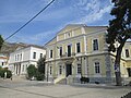 The town hall and the archaeological museum in Vathy
 -
 St Spyridon, Samos town
 -
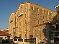 Old tobacco factory, Samos town
 -
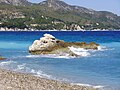 Kokkari beach
 -


See also
[edit]Notes
[edit]- ^ "Αποτελέσματα Απογραφής Πληθυσμού - Κατοικιών 2021, Μόνιμος Πληθυσμός κατά οικισμό" [Results of the 2021 Population - Housing Census, Permanent population by settlement] (in Greek). Hellenic Statistical Authority. 29 March 2024.
- ^ "Samos". Lexico UK English Dictionary. Oxford University Press. Archived from the original on 2020-08-06.
- ^ "Samos". The American Heritage Dictionary of the English Language (5th ed.). HarperCollins. Retrieved 6 July 2019.
- ^ "Samos". Collins English Dictionary. HarperCollins. Retrieved 6 July 2019.
- ^ "Samos". Merriam-Webster.com Dictionary. Merriam-Webster. Retrieved 6 July 2019.
- ^ a b c d e f g h i j k l m n o p Bunbury, Caspari & Gardner 1911, p. 116.
- ^ Strabo, Geography, 10.2.17
- ^ Everett-Heath, John (2017). The Concise Dictionary of World Place Names. Oxford University Press. ISBN 9780192556462.
- ^ Marozzi, Justin (2010-02-02). The Way of Herodotus: Travels with the Man Who Invented History. Hachette Books. ISBN 9780786727278.
- ^ Leaf, Walter (2010). Homer, the Iliad. Cambridge University Press. ISBN 9781108016872.
- ^ "Population & housing census 2001 (incl. area and average elevation)" (PDF) (in Greek). National Statistical Service of Greece. Archived from the original (PDF) on 2015-09-21.
- ^ "Conservation Action Plan for the golden jackal (Canis aureus) in Greece" (PDF). Archived from the original (PDF) on 2012-07-10. Retrieved 2012-11-07.
- ^ "Samos Climate". Hellenic National Meteorological Service. Archived from the original on 19 December 2011. Retrieved 15 October 2012.
- ^ "Climate Data for Samos". National Oceanic and Atmospheric Administration (FTP). Retrieved 15 October 2012.[dead ftp link] (To view documents see Help:FTP)
- ^ "Normales et records climatologiques 1981-2010 à Samos Airport - Infoclimat".
- ^ Tsetskhladze, Gocha R. (2006). Greek Colonisation. An account of Greek Colonies and Other Settlements Overseas. Vol. 1. Leiden, Boston: Brill. pp. lxvii - lxxiii (Table 6). ISBN 978-90-04-12204-8.
- ^ "Samos (island, Greece) - Britannica Online Encyclopedia". Britannica.com. Retrieved 2012-11-07.
- ^ The Siloam Tunnel was first Archived 2011-03-22 at the Wayback Machine
- ^ Thucydides, The Peloponnesian War, 1.117.3
- ^ a b Birken, Andreas (1976). Die Provinzen des Osmanischen Reiches. Beihefte zum Tübinger Atlas des Vorderen Orients (in German). Vol. 13. Reichert. p. 107. ISBN 9783920153568.
- ^ a b c d e f g h Landros Christos; Kamara Afroditi; Dawson Maria-Dimitra; Spiropoulou Vaso (10 July 2005). "Samos: 2.3. Ottoman rule". Cultural Portal of the Aegean Archipelago. Foundation of the Hellenic World. Archived from the original on 22 May 2013. Retrieved 2 April 2013.
- ^ a b c Landros Christos, Kamara Afroditi; Dawson Maria-Dimitra; Spiropoulou Vaso (10 July 2005). "Samos: 2.4. The Greek War of Independence, 1821". Cultural Portal of the Aegean Archipelago. Foundation of the Hellenic World. Archived from the original on 22 May 2013. Retrieved 2 April 2013.
- ^ "The Island of Samos".
- ^ Hall, Richard C. (2000). The Balkan Wars, 1912–1913: Prelude to the First World War. Routledge. p. 64. ISBN 0-415-22946-4.
- ^ Erickson, Edward J. (2003). Defeat in Detail: The Ottoman Army in the Balkans, 1912–1913. Greenwood Publishing Group. pp. 158–159. ISBN 0-275-97888-5..
- ^ Μιχάλης Φύλλας, «H επίσκεψη του Βασιλέως Γεωργίου β΄ στη Σάμο το 1937 μέσα από τον σαμιακό τύπο της εποχής: η περίπτωση των εφημερίδων « Σ ά μ ο ς » και « Α ι γ α ί ο ν » Δελτίον Σαμιακών Σπουδών, τομ. 5 (2019-2020), σελ.113-126 [1]
- ^ Vasileiou et al. 1987, pp. 9–12.
- ^ Margaritis 2006, pp. 424–439.
- ^ "ASN Aircraft Accident Shorts 330-200 SX-BGE". Archived from the original on 2012-11-10. Retrieved 2020-06-24.
- ^ "Greece to close Samos island migrant camp by year end". InfoMigrants. 28 April 2020. Retrieved 31 August 2020.
- ^ Bell, Bethany (22 January 2020). "Greek islanders strike over crowded migrant camps". BBC News. Retrieved 31 August 2020.
- ^ "Μετανάστες : "Πιλότος" η Σάμος για τις νέες δομές στα νησιά". in.gr (in Greek). 2020-11-17. Retrieved 2020-12-16.
- ^ Altunişik, Ahmet Can; Atmaca, Barbaros; Kartal, Murat Emre; Günaydin, Murat; Demir, Serhat; Uluşan, Alper (2021). "Assessment of Structural Damage Following the October 30, 2020 Aegean Sea Earthquake and Tsunami". Journal of Earthquake and Tsunami. 15 (6). doi:10.1142/S1793431121500299. ISSN 1793-4311.
- ^ "Τροποποίηση του άρθρου 1 του ν. 3852/2010" [Amendment of Article 1 of l. 3852/2010] (in Greek). Government Gazette. p. 1164.
- ^ "ΦΕΚ A 87/2010, Kallikratis Programme law text".
- ^ "Detailed census results 1991" (PDF). Archived from the original (PDF) on 2016-03-03. (39 MB) (in Greek and French)
- ^ Ioannis Spilanis, H. Vayanni et K. Glyptou (2012). Evaluating the tourism activity in a destination: the case of Samos Island, Revue Etudes Caribéennes, http://etudescaribeennes.revues.org/6257
- ^ "Pythagoreion and Heraion of Samos - UNESCO World Heritage Centre". Whc.unesco.org. 2009-09-18. Archived from the original on 29 November 2005. Retrieved 2012-11-07.
- ^ Yiannakis, John N., "Anna Perivolaris (1888–1963)", Australian Dictionary of Biography, Canberra: National Centre of Biography, Australian National University, retrieved 2024-02-17
References
[edit]- Attribution
This article incorporates text from a publication now in the public domain: Bunbury, Edward Herbert; Caspari, Maximilian Otto Bismarck; Gardner, Ernest Arthur (1911). "Samos". In Chisholm, Hugh (ed.). Encyclopædia Britannica. Vol. 24 (11th ed.). Cambridge University Press. pp. 116–117.
- Margaritis, Giorgos (2006). Ιστορία του ελληνικού εμφυλίου πολέμου 1946-1949 [History of the Greek Civil War 1946-1949] (in Greek). Vol. II. Athens: Vivliorama. ISBN 9608087139.
- Vasileiou, Theodoros; Diakogiannis, Manolis; Zafeiris, Giannis; Katsoufros, Kostas; Marinis, Kostas; Christodoulou, Epi (1987). Ο αγώνας του Δημοκρατικού στρατού στη Σάμο [The Struggle of the Democratic Army in Samos] (in Greek). Athens: Syghroni Epoxi. ISBN 9602249552.
Further reading
[edit]- Ancient sources
- Herodotus, especially book iii.
- Strabo xiv. pp. 636–639
- Thucydides, especially books i. and viii.
- Xenophon, Hellenica, books i. ii.
- Modern texts
- A. Agelarakis, "Anthropologic Results: The Geometric Period Necropolis at Pythagoreion". Archival Report. Samos Island Antiquities Authority, Greece, (2003).
- J. P. Barron, The Silver Coins of Samos (London, 1966).
- J. Boehlau, Aus ionischen and italischen Nekropolen (Leipzig, 1898). (E. H. B.; M. 0. B. C.; E. Ga.).
- C. Curtius, Urkunden zur Geschichte von Samos (Wesel, 1873).
- P. Gardner, Samos and Samian Coins (London, 1882).
- V. Guérin, Description de l'île de Patmos et de l'île de Samos (Paris, 1856).
- K. Hallof and A. P. Matthaiou (eds), Inscriptiones Chii et Sami cum Corassiis Icariaque (Inscriptiones Graecae, xii. 6. 1–2). 2 vols. (Berolini–Novi Eboraci: de Gruyter, 2000; 2004).
- B. V. Head, Historia Numorum (Oxford, 1887), pp. 515–518.
- L. E. Hicks and G. F. Hill, Greek Historical Inscriptions (Oxford, 1901), No. 81.
- H. Kyrieleis, Führer durch das Heraion von Samos (Athen, 1981).
- T. Panofka, Res Samiorum (Berlin, 1822).
- Pauly-Wissowa (in German, on Antiquity)
- T. J. Quinn, Athens and Samos, Chios and Lesbos (Manchester, 1981).
- G. Shipley, A History of Samos 800–188 BC (Oxford, 1987).
- R. Tölle-Kastenbein, Herodot und Samos (Bochum, 1976).
- H. F. Tozer, Islands of the Aegean (London, 1890).
- K. Tsakos, Samos: A Guide to the History and Archaeology (Athens, 2003).
- H. Walter, Das Heraion von Samos (München, 1976).
- Westermann, Großer Atlas zur Weltgeschichte (in German)
- Volumes of the Samos series of archaeological reports published by the Deutsches Archäologisches Institut.
- 1. V. Milojčić, Die prähistorische Siedlung unter dem Heraion (Bonn, 1961).
- 2. R. C. S. Felsch, Das Kastro Tigani (Bonn, 1988).
- 3. A. E. Furtwängler, Der Nordbau im Heraion von Samos (Bonn, 1989).
- 4. H. P. Isler, Das archaische Nordtor und seine Umgebung im Heraion von Samos (Bonn, 1978).
- 5. H. Walter, Frühe samische Gefäße (Bonn, 1968).
- 6.1. E. Walter-Karydi, Samische Gefäße des 6. Jahrhunderts v. Chr. (Bonn, 1973).
- 7. G. Schmidt, Kyprische Bildwerke aus dem Heraion von Samos (Bonn, 1968).
- 8. U. Jantzen, Ägyptische und orientalische Bronzen aus dem Heraion von Samos (Bonn, 1972).
- 9. U. Gehrikg, with G. Schneider, Die Greifenprotomen aus dem Heraion von Samos (Bonn, 2004).
- 10. H. Kyrieleis, Der große Kuros von Samos (Bonn, 1996).
- 11. B. Freyer-Schauenburg, Bildwerke der archaischen Zeit und des strengen Stils (Bonn, 1974).
- 12. R. Horn, Hellenistische Bildwerke auf Samos (Bonn, 1972).
- 14. R. Tölle-Kastenbein, Das Kastro Tigani (Bonn, 1974).
- 15. H. J. Kienast, Die Stadtmauer von Samos (Bonn, 1978).
- 16. W. Martini, Das Gymnasium von Samos (Bonn, 1984).
- 17. W. Martini and C. Streckner, Das Gymnasium von Samos: das frühbyzantinische Klostergut (Bonn, 1993).
- 18. V. Jarosch, Samische Tonfiguren aus dem Heraion von Samos (Bonn, 1994).
- 19. H. J. Kienast, Die Wasserleitung des Eupalinos auf Samos (Bonn, 1995).
- 20. U. Jantzen with W. Hautumm, W.-R. Megow, M. Weber, and H. J. Kienast, Die Wasserleitung des Eupalinos: die Funde (Bonn, 2004).
- 22. B. Kreuzer, Die attisch schwarzfigurige Keramik aus dem Heraion von Samos (Bonn, 1998).
- 24.1. T. Schulz with H. J. Kienast, Die römischen Tempel im Heraion von Samos: die Prostyloi (Bonn, 2002).
- 25. C. Hendrich, Die Säulenordnung des ersten Dipteros von Samos (Bonn, 2007).
External links
[edit] Samos travel guide from Wikivoyage
- Municipality of Samos
- Visit Samos

| Regional unit of Chios |  | |
|---|---|---|
| Regional unit of Ikaria | ||
| Regional unit of Lemnos | ||
| Regional unit of Lesbos | ||
| Regional unit of Samos | ||
| ||
| International | |
|---|---|
| National | |
| Geographic | |
| Other | |
Samos
View on GrokipediaEtymology
Origins and Interpretations
The name Samos likely derives from ancient terms denoting elevation or prominence, consistent with the island's rugged, mountainous terrain rising sharply from the Aegean Sea. The Greek geographer Strabo, writing in the 1st century BCE, attributed the name to Phoenician origins, interpreting it as sama, meaning "altitude near the coast" or "rise by the shore," a reference to the island's coastal heights. This etymology aligns with Phoenician maritime influence in the eastern Aegean during the Bronze Age, though direct linguistic evidence remains sparse and reliant on Strabo's testimony.[7] An alternative interpretation posits a native Greek or Ionian root in words like samo or sama, signifying "height," "dune," or "seaside hill," as the term appears in ancient Greek denoting elevated landforms.[11] This view emphasizes the island's topography, with peaks exceeding 1,400 meters, and is supported by linguistic parallels in Ionian dialects spoken by early settlers.[12] Scholarly consensus holds that both Phoenician and Greek derivations converge on the core meaning of "high land," potentially reflecting pre-Greek substrate influences or convergent evolution in Semitic and Indo-European vocabularies for geographic features.[13] Earlier names for the island, such as Parthenia (maiden island), appear in mythological accounts but do not explain the persistent Samos designation, which is attested in Linear B texts from the Mycenaean period around 1400 BCE as Sa-mo.[14] While some biblical etymologists link it to Hebrew sammah (to rejoice or be high), this connection lacks archaeological or textual support in the Aegean context and stems from typological rather than historical linguistics.[15] The absence of definitive pre-Ionian records underscores ongoing debate, with topographic descriptiveness providing the most empirically grounded explanation.Geography
Location and Topography
Samos is a Greek island situated in the eastern Aegean Sea, approximately 1.2 km from the Anatolian coast of Turkey, within the North Aegean administrative region.[16] It lies between latitudes 37°37' N and 37°49' N and longitudes 26°33' E and 27°10' E, south of Chios and north of the Dodecanese islands.[17] The island spans a surface area of approximately 480 km², with a major axis of 43 km and a minor axis of 19 km, and possesses a coastline measuring 160.9 km.[16] The topography of Samos is predominantly mountainous, dominated by two principal ranges: the western Kerkis (also known as Kerketeus), which reaches an elevation of 1,433 m at its highest peak, Profitis Ilias, and the central-eastern Ampelos range, which is lower but extends across much of the island's interior.[18] These ranges feature steep slopes, deep ravines, and fertile valleys interspersed with small plains that support olive groves, vineyards, and citrus orchards.[3] The island lacks permanent rivers, relying instead on seasonal streams and creeks that flow through gorges during wetter periods, contributing to its rugged, verdant landscape.[19] Geologically, Samos exposes rocks from the Cycladic blueschist unit, including high-pressure metamorphic formations sandwiched between less deformed sequences, reflecting a complex tectonic history involving subduction and exhumation processes.[20] The terrain's elevation varies from coastal lowlands to the interior highlands, with the mountainous core covering nearly the entire island and limiting large-scale flatlands.[4]Climate
Samos has a hot-summer Mediterranean climate classified as Csa under the Köppen system, featuring hot, dry summers and mild, wetter winters influenced by its Aegean location and northerly winds.[21] Annual mean temperature averages 18.9 °C based on data from 1978 to 2010 recorded at low elevation.[22] Precipitation totals approximately 704.5 mm yearly, concentrated from November to April, with about 73.5 rainy days annually; summers are nearly rainless, supporting agriculture reliant on winter rains and irrigation.[22] Summer temperatures peak in July with a mean of 28.9 °C, maximums reaching 33.0 °C, and minimums at 22.8 °C, while January means 10.5 °C with highs of 13.5 °C and lows of 7.2 °C.[22] Humidity is lowest in summer at around 44% in July, rising to 71% in winter, and winds predominantly from the north average 9-12 km/h, stronger during the summer meltemi period.[22] [23] The island's topography, with peaks exceeding 1,400 m, creates microclimatic variations, where higher elevations experience cooler temperatures and slightly higher rainfall due to orographic effects.[24]| Month | Mean Temp (°C) | Precip (mm) | Precip Days |
|---|---|---|---|
| Jan | 10.5 | 135.0 | 11.7 |
| Jul | 28.9 | 0.5 | 0.2 |
| Annual | 18.9 | 704.5 | 73.5 |
Flora and Fauna
Samos exhibits a rich vascular plant diversity exceeding 1,500 species and subspecies, with nine taxa endemic to the island and thirteen additional local endemics shared across Aegean islands.[25] Dominant vegetation zones include Aleppo pine (Pinus brutia) forests on montane slopes up to 1,000 meters elevation, evergreen oak woodlands featuring holm oak (Quercus ilex) and kermes oak (Quercus coccifera), and phryganic maquis shrublands composed of species such as strawberry tree (Arbutus unedo), mastic (Pistacia lentiscus), and rockrose (Cistus spp.). Relict stands of valonia oak (Quercus ithaburensis subsp. macrolepis), a deciduous species reaching 15–20 meters in height, persist in northern and central areas, supporting specialized understory flora.[26] [27] Notable endemics encompass the larkspur Consolida samia, confined to serpentine outcrops and classified as critically endangered due to habitat loss, and the near-endemic Jerusalem sage Phlomis samiensis, adapted to rocky limestone substrates.[28] [29] The island's fauna reflects its varied topography, from coastal wetlands to inland forests, hosting 139 bird species overall, of which 39 are resident year-round, including Eleonora's falcon (Falco eleonorae), Eurasian eagle-owl (Bubo bubo), and various raptors that breed in cliffside habitats.[30] Herpetofauna comprises 28 species, encompassing four amphibians like the marsh frog (Pelophylax ridibundus) and 24 reptiles such as the Anatolian rock lizard (Anatololacerta anatolica) and Balkan green lizard (Lacerta viridis), with distributions influenced by microhabitats ranging from xeric lowlands to mesic ravines.[31] Mammalian presence includes the golden jackal (Canis aureus), monitored through camera traps revealing family groups in forested and agricultural edges since 2023, alongside red fox (Vulpes vulpes) and stone marten (Martes foina).[32] Invertebrate diversity is pronounced, featuring at least 69 butterfly species and 18 staphylinid beetle taxa exclusive to Samos, many associated with decaying wood and leaf litter in oak-pine ecosystems.[33] Surrounding Aegean waters support marine megafauna, including vulnerable Mediterranean monk seals (Monachus monachus) and common bottlenose dolphins (Tursiops truncatus), with sightings concentrated near coastal caves and bays.[34]History
Prehistory and Early Antiquity
Archaeological evidence indicates human presence on Samos during the Neolithic period, with the earliest finds dating to the 5th/4th millennium BC at sites such as the Heraion sanctuary and the area of modern Pythagoreion (ancient Tigani).[5] Pottery and settlement traces from this era suggest initial agricultural communities, though sparse compared to later periods. Additional Neolithic material has been identified in the Seitani Cave in northern Samos, featuring ceramic assemblages indicative of early tool use and subsistence strategies.[35] The Early Bronze Age saw significant development at the Heraion, where excavations reveal the largest island settlement in the Aegean during this phase, centered along the Sacred Road with evidence of organized habitation and ritual activity by around 3000–2000 BC.[36] Late Bronze Age occupation is attested by Mycenaean pottery and structures, pointing to continental Greek influences around 1600–1100 BC, potentially linking Samos to broader Aegean networks disrupted by the collapse of palatial systems.[37] Following this, Carian populations may have settled before Ionian Greek colonization c. 1100 BCE, marking a transition to proto-historic phases with emerging Greek cultural elements.[37] In early antiquity, from the 10th century BC, the main urban settlement coalesced at Tigani, evolving into the ancient city of Samos (later Pythagoreion), with fortifications and harbors supporting maritime trade.[5] The Heraion sanctuary emerged as a focal point by the 8th century BC, initially as a simple structure housing a wooden image of Hera beneath a sacred tree, evolving into one of the earliest large Greek temples and symbolizing Ionian religious centrality.[38] This period laid foundations for Samos's Archaic prosperity, with votive offerings and architectural innovations reflecting growing wealth from agriculture, viticulture, and eastern contacts.[39]Classical Antiquity
During the Archaic period, Samos achieved remarkable prosperity and cultural prominence under the tyrant Polycrates (r. c. 535–522 BCE), who seized power with his brothers and established naval supremacy in the eastern Aegean Sea.[40] Polycrates expanded Samian influence through alliances, trade, and military campaigns, commissioning grand architectural projects that symbolized the island's wealth, including enhancements to the Heraion sanctuary and the innovative Eupalinian aqueduct.[41] The aqueduct, constructed around 550–530 BCE by the engineer Eupalinus, featured a 1,036-meter tunnel bored through Mount Kastro from both ends to meet precisely, supplying water to the ancient city and exemplifying advanced hydraulic engineering.[42] The island's intellectual legacy included the birth of the philosopher and mathematician Pythagoras c. 570 BCE, who departed Samos amid Polycrates' rule, seeking refuge in Croton where he founded his influential school.[43] The Heraion of Samos, a vast sanctuary dedicated to Hera dating back to Mycenaean times but flourishing in the 6th century BCE, became a center of Ionic sculpture and religious pilgrimage, with its dipteral temple (measuring approximately 52 by 108 meters) adorned by renowned artists like Roikos and Geneleos.[5] This period marked Samos as a hub of artistic and technical innovation, with its red-figure pottery and iron resources contributing to regional trade.[6] Samos played a pivotal role in the Ionian Revolt (499–493 BCE) against Persian rule, providing ships to the allied fleet but defecting during the decisive Battle of Lade in 494 BCE due to internal dissent, which contributed to the rebels' defeat and Persian reconquest of the island.[44] Following submission to Persia, Samos fought on the Persian side at the Battle of Salamis (480 BCE) but later revolted again, aligning with Athens and joining the Delian League by c. 478 BCE, thereby integrating into the Athenian maritime empire during the Classical period.[45] This alliance brought periods of stability and tribute contributions but also tensions, culminating in conflicts like the Samian War (440–439 BCE), after which Athenian dominance was imposed through democratic reforms and a cleruchy.Hellenistic and Roman Periods
Following the death of Alexander the Great, Samos navigated the power struggles of the Diadochi, with returning exiles facing arrest in 323 BC before resettling after Perdiccas expelled Athenian influence in 321 BC.[46] By circa 280 BC, the historian Duris established a tyranny on the island, reflecting ongoing internal political instability amid broader Hellenistic dynamics.[46] In the mid-third century BC, Samos became a strategic Ptolemaic naval base from 246 BC, hosting fleets during conflicts with the Antigonids; however, Philip V of Macedon captured it from Ptolemy IV in 205 BC as part of his eastern campaigns.[37] The island oscillated between Ptolemaic, Seleucid, and Rhodian influences through the late third century, maintaining its role as a key Aegean maritime hub while arbitrating local disputes, such as border conflicts with Priene resolved by Rhodian mediators in 192 BC.[46][47] During the Roman-Seleucid War (192–188 BC), Samos allied with Rome against Antiochus III, contributing naval forces that aided in his defeat at Magnesia in 190 BC; in recognition, the Treaty of Apamea in 188 BC confirmed Samian autonomy, exempting it from tribute and reinforcing its independence as a reward for loyalty.[37] This brief era of self-governance ended with Pergamon's bequest to Rome upon Attalus III's death in 133 BC, incorporating Samos into the province of Asia despite Roman senatorial oversight of its ongoing border disputes with Priene as late as 135 BC.[46] Under Roman rule, Samos initially retained some privileges but rebelled alongside Aristonicus in 132 BC, prompting suppression and tighter provincial integration.[37] It later sided with Mithridates VI Eupator during the First Mithridatic War (88–85 BC), aligning against Roman forces; following Sulla's victories, the island faced severe reprisals, including fines, confiscations, and loss of autonomy, as part of broader penalties imposed on disloyal Asian cities documented by Appian.[48] Despite these setbacks, Samos prospered as a mercantile center and elite resort in the early Imperial era, attracting figures like Mark Antony and Cleopatra for leisure; Augustus restored its freedom via decree after 65 BC, as inscribed in Samian records.[49][46] Archaeological remains, including Roman thermae and athletic facilities integrated with earlier infrastructure like the Eupalinian aqueduct, attest to sustained urban development and cultural continuity under provincial administration.[39][5]Medieval and Ottoman Eras
Following the Roman era, Samos transitioned into the Byzantine Empire, where early Christian basilicas were constructed by the 5th century, reflecting influences from nearby Ephesus and signaling initial Christianization.[50] Trade flourished in the 6th century, evidenced by basilica expansions tied to olive oil and wine production, while a diocese was established by the same century, with an auxiliary bishop in Rhodes persisting until the 12th century.[50] However, Arab forces under Moabius I raided the island in 665 AD, prompting defensive measures.[50] By the 8th-9th centuries, Samos formed the core of the naval Theme of Samos, serving as head of the Aegean military district until the 11th-12th centuries, which involved fortification efforts amid ongoing threats.[50][51] In the Middle Byzantine period, Samos operated as the 29th eparchy of the islands and was elevated to the metropolis of the Samian administrative theme under Emperor Constantine VII Porphyrogenitus in the 10th century, coinciding with its role as a base for both Arab raids into the Aegean and Byzantine counteroffensives.[52][51] Rural prosperity supported monument construction into the 12th century, though coastal settlements were increasingly abandoned for inland refuges like fortified sites at Kastrovouni and Lazarus’ Castle due to persistent raids.[50][51] The Fourth Crusade's sack of Constantinople in 1204 brought Samos under Latin rule, but Emperor John III Vatatzes reclaimed it for Byzantium in 1225.[51] Genoese forces seized control in 1304, imposing taxation linked to the Giustiniani knights of Chios; brief Byzantine recovery occurred in 1329 before renewed Genoese dominance from 1346 under the Giustiniani family, which lasted until 1475 amid escalating pirate threats and plague.[52][6][51] Ottoman conquest integrated Samos into the empire around 1479-1480, by which time piracy and epidemics had severely depopulated the island, leaving it nearly deserted.[51][53] Repopulation efforts began in the mid-16th century under Admiral Kılıç Ali Pasha, who in 1549-1573 issued a sultanic firman granting tax exemptions, land rights, and self-governance privileges to Orthodox Greek settlers from Anatolia, the Peloponnese, and other Aegean areas, fostering village formation and reaching approximately 10,000 inhabitants by the 17th century.[50][54][51] Administration combined Ottoman oversight with local autonomy: initially led by a Christian voivode (church warden), later by a sultan-appointed disdar advised by four elected elders and a kadi, enabling cultivation of abandoned lands and late-18th-century growth in shipping and trade.[54][51] Brief Russian occupation from 1771 to 1774 introduced external influences, followed by reforms under the Karmanioles faction (1807-1812) that promoted Enlightenment ideas via new settlers from the Ionian Islands and Peloponnese.[54][51] Samos resisted full Ottoman integration during the Greek War of Independence; in 1821, Lykourgos Logothetis led a successful uprising, repelling a 1824 Ottoman naval siege through the Battle of Samos, which preserved de facto independence.[54][55] Formal autonomy was recognized in 1834 as the Principality of Samos (or Hegemony), requiring annual tribute to the Porte while maintaining internal self-rule under princes like Andreas Kritis, until annexation to Greece in 1912.[50][51]Modern Period and Independence
Samos actively participated in the Greek War of Independence, with revolutionary uprisings beginning on April 18, 1821, in the main town and May 8, 1821, in Karlovasi.[56] Samiotes, led by figures such as Lykourgos Logothetis, achieved notable victories against Ottoman and Egyptian forces, including the destruction of a Turkish naval vessel early in the conflict.[57] Despite these successes, the island faced repeated invasions and was not incorporated into the newly independent Greek state established by the 1830 London Protocol. In 1834, following negotiations and internal pressures, Samos was established as the autonomous Principality of Samos, a tributary state under Ottoman suzerainty, required to pay an annual tribute of £2,700.[58] Governed by Christian princes appointed by the Sultan, with Logothetis initially serving as the first president or governor, the principality enjoyed self-administration, its own flag, and legislative assembly while remaining nominally Ottoman.[47] The capital was relocated from Chora to Vathy in 1854, spurring urban development with public buildings.[59] Over the period, multiple revolts occurred against unpopular princes, reflecting tensions between local autonomy aspirations and Ottoman oversight.[60] The principality's status ended amid the Balkan Wars. In September 1912, a revolution erupted under the leadership of Themistokles Sophoulis, prompting Ottoman forces to withdraw by late September.[6] On November 11, 1912, Samos's national assembly in Vathy declared union with the Kingdom of Greece.[61] The formal annexation was ratified internationally on March 2, 1913, integrating Samos fully into Greece and concluding nearly four centuries of Ottoman influence.[62]Demographics
Population Dynamics
The population of the Regional Unit of Samos stood at 32,642 residents according to the 2011 census conducted by the Hellenic Statistical Authority (ELSTAT), remaining at the same level in the 2021 census despite a reported -1.0% change over the decade.[63] This relative stability bucks national trends of depopulation in Greece, where the overall resident population fell from 10,816,286 in 2011 to 10,482,487 in 2021, primarily due to sub-replacement fertility rates (around 1.3 births per woman) and net emigration exceeding natural increase.[64] [63] Intra-regional shifts contributed to the aggregate balance: the municipality of Anatoliki Samos declined from 20,513 inhabitants in 2011 to 20,021 in 2021, reflecting outflows from the densely populated eastern areas including the capital Vathi, while Dytiki Samos grew marginally from 12,464 to 12,621, possibly buoyed by localized economic factors in western settlements like Karlovasi.[63] Low birth rates, consistent with Aegean island patterns where fertility often falls below 1.2 per woman, combine with youth out-migration to mainland Greece or abroad for education and employment, exerting downward pressure; however, seasonal tourism and limited return migration have offset sharper declines observed elsewhere in peripheral regions.[63] [65]| Year | Total Regional Unit | Anatoliki Samos | Dytiki Samos |
|---|---|---|---|
| 2011 | 32,642 | 20,513 | 12,464 |
| 2021 | 32,642 | 20,021 | 12,621 |