Hubbry Logo
StreamStreamMain
Open search
Stream
Community hub
Stream
logo
8 pages, 0 posts
0 subscribers
Be the first to start a discussion here.
Stream
Stream
from Wikipedia
Rocky stream in Italy
Frozen stream in Enäjärvi, Pori, Finland
Stream near Montriond in south-eastern France
Aubach (Wiehl) in North Rhine-Westphalia, Germany

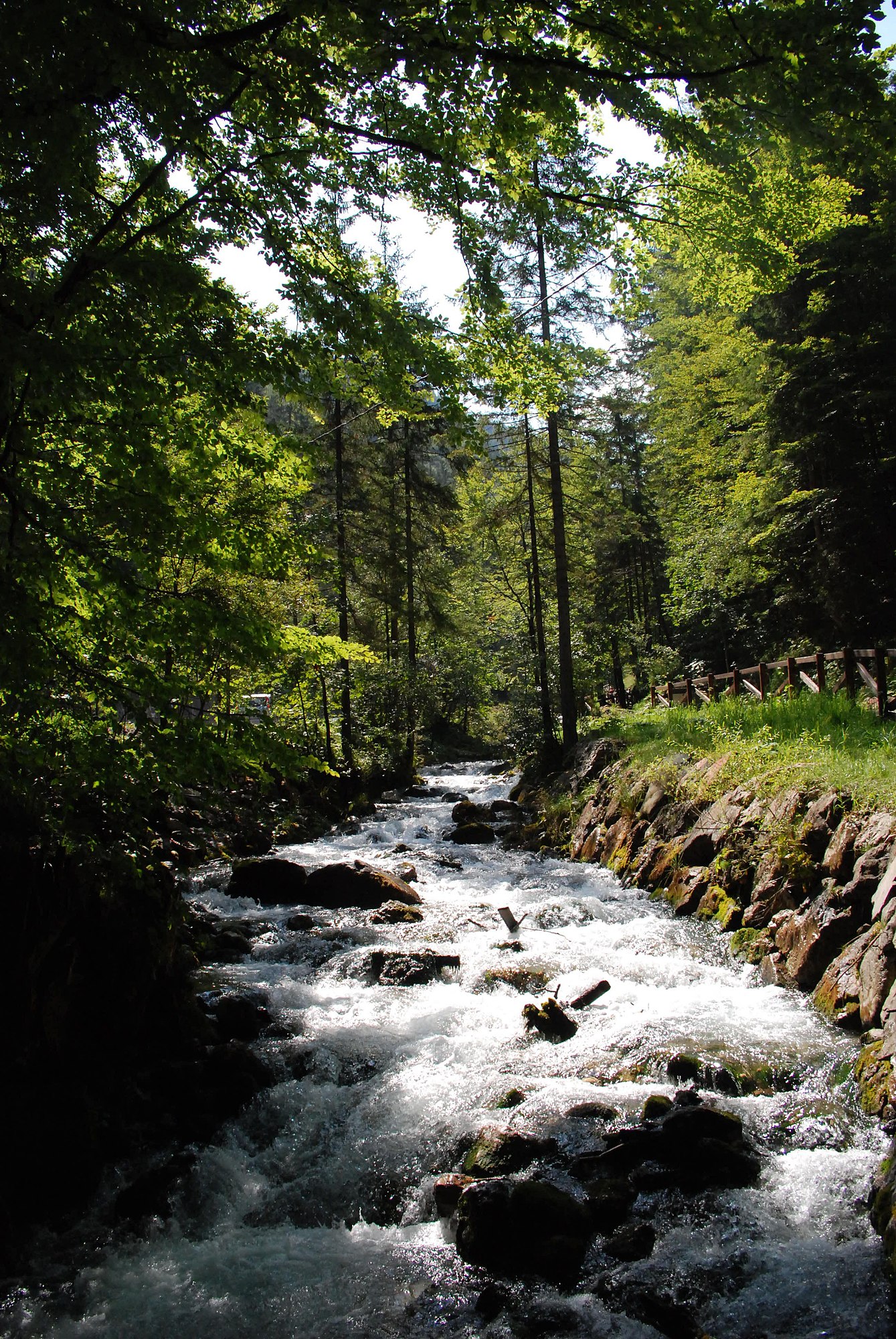
A stream is a continuous body of surface water[1] flowing within the bed and banks of a channel. Depending on its location or certain characteristics, a stream may be referred to by a variety of local or regional names. Long, large streams are usually called rivers, while smaller, less voluminous and more intermittent streams are known, amongst others, as brook, creek, rivulet, rill, run, tributary, feeder, freshet, narrow river, and streamlet.[2]

The flow of a stream is controlled by three inputs – surface runoff (from precipitation or meltwater), daylighted subterranean water, and surfaced groundwater (spring water). The surface and subterranean water are highly variable between periods of rainfall. Groundwater, on the other hand, has a relatively constant input and is controlled more by long-term patterns of precipitation.[3] The stream encompasses surface, subsurface and groundwater fluxes that respond to geological, geomorphological, hydrological and biotic controls.[4]

Streams are important as conduits in the water cycle, instruments in groundwater recharge, and corridors for fish and wildlife migration. The biological habitat in the immediate vicinity of a stream is called a riparian zone. Given the status of the ongoing Holocene extinction, streams play an important corridor role in connecting fragmented habitats and thus in conserving biodiversity. The study of streams and waterways in general is known as surface hydrology and is a core element of environmental geography.[5]

Types

[edit]
Creek babbling through Benvoulin, Canada, wetlands
Wyming Brook in Sheffield, UK
A small stream in Lake Parramatta, Sydney
Stream with low gradient surrounded by natural riparian vegetation (Rhineland-Palatinate)
A low level stream in Macon County, Illinois

Brook

[edit]

A brook is a stream smaller than a creek, especially one that is fed by a spring or seep. It is usually small and easily forded. A brook is characterised by its shallowness.

Creek

[edit]

A creek (/krk/) or crick (/krɪk/):[6][7]

In hydrography, gut is a small creek;[15] this is seen in proper names in eastern North America from the Mid-Atlantic states (for instance, The Gut in Pennsylvania, Ash Gut in Delaware,[16] and other streams)[17] down into the Caribbean (for instance, Guinea Gut, Fish Bay Gut, Cob Gut, Battery Gut and other rivers and streams in the United States Virgin Islands, in Jamaica (Sandy Gut,[18] Bens Gut River,[19] White Gut River), and in many streams and creeks of the Dutch Caribbean).[20]

River

[edit]

A river is a large natural stream that is much wider and deeper than a creek and not easily fordable, and may be a navigable waterway.[21]

Runnel

[edit]

The linear channel between the parallel ridges or bars on a shoreline beach or river floodplain, or between a bar and the shore. Also called a swale.

Tributary

[edit]

A tributary is a contributory stream to a larger stream, or a stream which does not reach a static body of water such as a lake, bay or ocean[22] but joins another river (a parent river). Sometimes also called a branch or fork.[23]

Distributary

[edit]

A distributary, or a distributary channel, is a stream that branches off and flows away from a main stream channel, and the phenomenon is known as river bifurcation. Distributaries are common features of river deltas, and are often found where a valleyed stream enters wide flatlands or approaches the coastal plains around a lake or an ocean. They can also occur inland, on alluvial fans, or where a tributary stream bifurcates as it nears its confluence with a larger stream. Common terms for individual river distributaries in English-speaking countries are arm and channel.

Other names

[edit]

There are a number of regional names for a stream.

Northern America

[edit]

United Kingdom

[edit]
[edit]
Bar
A shoal that develops in a stream as sediment is deposited as the current slows or is impeded by wave action at the confluence.
Bifurcation
A fork into two or more streams.
Channel
A depression created by constant erosion that carries the stream's flow.
Confluence
The point at which the two streams merge. If the two tributaries are of approximately equal size, the confluence may be called a fork.
Drainage basin
(also known as a watershed in the United States) The area of land where water flows into a stream. A large drainage basin such as the Amazon River contains many smaller drainage basins.[35]
Floodplain
Lands adjacent to the stream that are subject to flooding when a stream overflows its banks.[35]
Headwaters or source
The part of a stream or river proximate to its source. The word is most commonly used in the plural where there is no single point source.[35]
Knickpoint
The point on a stream's profile where a sudden change in stream gradient occurs.
Mouth
The point at which the stream discharges, possibly via an estuary or delta, into a static body of water such as a lake or ocean.
Pool
A segment where the water is deeper and slower moving.
Rapids
A turbulent, fast-flowing stretch of a stream or river.
Riffle
A segment where the flow is shallower and more turbulent.
River
A large natural stream, which may be a waterway.[35]
Run
A somewhat smoothly flowing segment of the stream.
Spring
The point at which a stream emerges from an underground course through unconsolidated sediments or through caves. A stream can, especially with caves, flow aboveground for part of its course, and underground for part of its course.[35]
Stream bed
The bottom of a stream.
Stream corridor
Stream, its floodplains, and the transitional upland fringe.[36]
Streamflow
The water moving through a stream channel.[35]
Stream gauge
A site along the route of a stream or river, used for reference marking or water monitoring.[35]
Thalweg
The river's longitudinal section, or the line joining the deepest point in the channel at each stage from source to mouth.
Watercourse
The channel followed by a stream (a flowing body of water)[37] or the stream itself.[38][39][40] In the UK, some aspects of criminal law, such as the Rivers (Prevention of Pollution) Act 1951, specify that a watercourse includes those rivers which are dry for part of the year.[41] In some jurisdictions, owners of land over which the water flows may have the legal right to use or retain some or much of that water.[42] This right may extend to estuaries, rivers, streams, anabranches[43] and canals.[44]
Waterfall or cascade
The fall of water where the stream goes over a sudden drop called a knickpoint; some knickpoints are formed by erosion when water flows over an especially resistant stratum, followed by one less so. The stream expends kinetic energy as it flows over the knickpoint.
Wetted perimeter
The line on which the stream's surface meets the channel walls.

Sources

[edit]
Small tributary stream, Diamond Ridge, Alaska
Creek in Perisher Ski Resort, Australia

A stream's source depends on the surrounding landscape and its function within larger river networks. While perennial and intermittent streams are typically supplied by smaller upstream waters and groundwater, headwater and ephemeral streams often derive most of their water from precipitation in the form of rain and snow.[45] Most of this precipitated water re-enters the atmosphere by evaporation from soil and water bodies, or by the evapotranspiration of plants. Some of the water proceeds to sink into the earth by infiltration and becomes groundwater, much of which eventually enters streams. Some precipitated water is temporarily locked up in snow fields and glaciers, to be released later by evaporation or melting. The rest of the water flows off the land as runoff, the proportion of which varies according to many factors, such as wind, humidity, vegetation, rock types, and relief. This runoff starts as a thin film called sheet wash, combined with a network of tiny rills, together constituting sheet runoff; when this water is concentrated in a channel, a stream has its birth. Some creeks may start from ponds or lakes.

Stream in Alberta

The streams typically derive most of their water from rain and snow precipitation. Most of this water re-enters the atmosphere either by evaporation from soil and water bodies, or by plant evapotranspiration. By infiltration some of the water sinks into the earth and becomes groundwater, much of which eventually enters streams. Most precipitated water is partially bottled up by evaporation or freezing in snow fields and glaciers. The majority of the water flows as a runoff from the ground; the proportion of this varies depending on several factors, such as climate, temperature, vegetation, types of rock, and relief. This runoff begins as a thin layer called sheet wash, combined with a network of tiny rills, which together form the sheet runoff; when this water is focused in a channel, a stream is born. Some rivers and streams may begin from lakes or ponds.

Freshwater's primary sources are precipitation and mountain snowmelt. However, rivers typically originate in the highlands, and are slowly created by the erosion of mountain snowmelt into lakes or rivers. Rivers usually flow from their source topographically, and erode as they pass until they reach the base stage of erosion.

Some scientists have proposed a critical support flow (CSD) concept and model to determine the hydrographic indicators of river sources in complex geographical areas.[46]

The source of a river or stream (its point of origin) can consist of lakes, swamps, springs, or glaciers. A typical river has several tributaries; each of these may be made up of several other smaller tributaries, so that together this stream and all its tributaries are called a drainage network. Although each tributary has its own source, international practice is to take the source farthest from the river mouth as the source of the entire river system, from which the most extended length of the river measured as the starting point is taken as the length of the whole river system,[47] and that furthest starting point is conventionally taken as the source of the whole river system. For example, the origin of the Nile River is the confluence of the White Nile and the Blue Nile, but the source of the whole river system is in its upper reaches. If there is no specific designation, "length of the Nile" refers to the "river length of the Nile system", rather than to the length of the Nile river from the point where it is formed by a confluence of tributaries. The Nile's source is often cited as Lake Victoria, but the lake has significant feeder rivers. The Kagera River, which flows into Lake Victoria near Bukoba's Tanzanian town[clarification needed], is the longest feeder, though sources do not agree on which is the Kagera's longest tributary and therefore the Nile's most remote source itself.[48][49]

Characteristics

[edit]

Ranking

[edit]

To qualify as a stream, a body of water must be either recurring or perennial. Recurring (intermittent) streams have water in the channel for at least part of the year. A stream of the first order is a stream which does not have any other recurring or perennial stream feeding into it. When two first-order streams come together, they form a second-order stream. When two second-order streams come together, they form a third-order stream. Streams of lower order joining a higher order stream do not change the order of the higher stream.

Gradient

[edit]

The gradient of a stream is a critical factor in determining its character and is entirely determined by its base level of erosion. The base level of erosion is the point at which the stream either enters the ocean, a lake or pond, or enters a stretch in which it has a much lower gradient, and may be specifically applied to any particular stretch of a stream.

In geological terms, the stream will erode down through its bed to achieve the base level of erosion throughout its course. If this base level is low, then the stream will rapidly cut through underlying strata and have a steep gradient, and if the base level is relatively high, then the stream will form a flood plain and meander.

Profile

[edit]
Profiles of the Umpqua River.

Typically, streams are said to have a particular elevation profile, also known as longitudinal profile or long profile. It begins at the source with steep gradients, no flood plain, and little shifting of channels, eventually evolving into streams with low gradients, wide flood plains, and extensive meanders. The initial stage is sometimes termed a "young" or "immature" stream, and the later state a "mature" or "old" stream. A stream cross profile is a cross section from bank to bank.

Meander

[edit]

Meanders are looping changes of direction of a stream caused by the erosion and deposition of bank materials. These are typically serpentine in form. Typically, over time the meanders gradually migrate downstream. If some resistant material slows or stops the downstream movement of a meander, a stream may erode through the neck between two legs of a meander to become temporarily straighter, leaving behind an arc-shaped body of water termed an oxbow lake or bayou. A flood may also cause a meander to be cut through in this way.

Stream load

[edit]

The stream load is defined as the solid matter carried by a stream. Streams can carry sediment, or alluvium. The amount of load it can carry (capacity) as well as the largest object it can carry (competence) are both dependent on the velocity of the stream.

Classification

[edit]

Perennial or not

[edit]
Whites Creek a small perennial stream in the Ozarks of southern Missouri
The Gangi River of Arrah, India

A perennial stream is one which flows continuously all year.[50]: 57  Some perennial streams may only have continuous flow in segments of its stream bed year round during years of normal rainfall.[50][51] Blue-line streams are perennial streams and are marked on topographic maps with a solid blue line.

The word "perennial" from the 1640s, meaning "evergreen," is established in Latin perennis, keeping the meaning as "everlasting all year round," per "over" plus annus "year." This has been proved since the 1670s by the "living years" in the sense of botany. The metaphorical sense of "enduring, eternal" originates from 1750. They are related to "perennial." See biennial for shifts in vowels.[52]

Perennial streams have one or more of these characteristics:

  1. Direct observation or compelling evidence suggests that there is no interruption in the flow at ground.
  2. The existence of one or more specific features of the perennial streams, including:
    • Riverbed forms, for example, riffles, pools, runs, gravel bars, other depositional characteristics, bed armor layer.
    • Riverbank erosion and/or polishment.
    • Indications of waterborne debris and sediment transport.
    • Defined river or stream bed and banks.
  3. The catchment area exceeds .25 square miles (0.65 km2).
  4. USGS regression on the VHD data layer-oriented[definition needed] application on the probability of intermittent flow.
  5. The existence of aquatic organisms that require uninterrupted circulation.
  6. As shown by bank leakage, spring, or other indicators, grass-roots flow mainly supports groundwater recharge.
  7. There are high channels of permeability, especially stratospheric, boundary conditions; while stratospheric groundwater also decreases on occasion.
  8. Existence of native aquatic organisms which require undisturbed survival flow.
  9. The surrounding topography exhibits features of being formed by fluvial processes.

Absence of such characteristics supports classifying a stream as intermittent, "showing interruptions in time or space".[53]

Ephemeral stream

[edit]
Ephemeral stream in Mont Pelat, Mercantour National Park.

Generally, streams that flow only during and immediately after precipitation are termed ephemeral. There is no clear demarcation between surface runoff and an ephemeral stream,[50]: 58  and some ephemeral streams can be classed as intermittent—flow all but disappearing in the normal course of seasons but ample flow (backups) restoring stream presence — such circumstances are documented when stream beds have opened up a path into mines or other underground chambers.[54]

According to official U.S. definitions, the channels of intermittent streams are well-defined,[55] as opposed to ephemeral streams, which may or may not have a defined channel, and rely mainly on storm runoff, as their aquatic bed is above the water table.[56] An ephemeral stream does not have the biological, hydrological, and physical characteristics of a continuous or intermittent stream.[56] The same non-perennial channel might change characteristics from intermittent to ephemeral over its course.[56]

Intermittent or seasonal stream

[edit]
Australian creek, low in the dry season, carrying little water. The energetic flow of the stream had, in flood, moved finer sediment further downstream. There is a pool to lower right and a riffle to upper left of the photograph.
A small, narrow stream flowing down a tiny dell in Pennsylvania.

Washes can fill up quickly during rains, and there may be a sudden torrent of water after a thunderstorm begins upstream, such as during monsoonal conditions. In the United States, an intermittent or seasonal stream is one that only flows for part of the year and is marked on topographic maps with a line of blue dashes and dots.[50]: 57–58  A wash, desert wash, or arroyo is normally a dry streambed in the deserts of the American Southwest, which flows after sufficient rainfall.

In Italy, an intermittent stream is termed a torrent (Italian: torrente). In full flood the stream may or may not be "torrential" in the dramatic sense of the word, but there will be one or more seasons in which the flow is reduced to a trickle or less. Typically torrents have Apennine rather than Alpine sources, and in the summer they are fed by little precipitation and no melting snow. In this case the maximum discharge will be during the spring and autumn.

An intermittent stream can also be called a winterbourne in Britain, a wadi in the Arabic-speaking world or torrente or rambla (this last one from Arabic origin) in Spain and Latin America. In Australia, an intermittent stream is usually called a creek and marked on topographic maps with a solid blue line.[citation needed]

Consequential or not

[edit]

There are five generic classifications:

  • Consequent streams are streams whose course is a direct consequence of the original slope of the surface[57] upon which it developed, i.e., streams that follow slope of the land over which they originally formed.

  • Subsequent streams are streams whose course has been determined by selective headward erosion along weak strata. These streams have generally developed after the original stream. Subsequent streams developed independently of the original relief of the land and generally follow paths determined by the weak rock belts.
  • Resequent streams are streams whose course follows the original relief, but at a lower level than the original slope (e.g., flows down a course determined by the underlying strata in the same direction). These streams develop later and are generally a tributary to a subsequent stream.[58]
  • Obsequent streams are streams flowing in the opposite direction of the consequent drainage.
  • Insequent streams have an almost random drainage often forming dendritic patterns. These are typically tributaries and have developed by a headward erosion on a horizontally stratified belt or on homogeneous rocks. These streams follow courses that apparently were not controlled by the original slope of the surface, its structure or the type of rock.

According to the water underneath

[edit]
  • Gaining: A stream or path to receive water from groundwater.
  • Losing: A stream or reach of a stream which shows a net loss of water to groundwater or evaporation.
  • Isolated: The water flow or channel shall not supply or remove water from the saturated region.
  • Perched: refers to the loss or isolation flow separated from the groundwater in the air zone. Classification[1]

Indicators of a perennial stream

[edit]

Benthic macroinvertebrates

[edit]

"Macroinvertebrate" refers to easily seen invertebrates, larger than 0.5 mm, found in stream and river bottoms.[59] Macroinvertebrates are larval stages of most aquatic insects and their presence is a good indicator that the stream is perennial. Larvae of caddisflies, mayflies, stoneflies, and damselflies[60] require a continuous aquatic habitat until they reach maturity. Crayfish and other crustaceans, snails, bivalves (clams), and aquatic worms also indicate the stream is perennial. These require a persistent aquatic environment for survival.[61]

Vertebrates

[edit]

Fish and amphibians are secondary indicators in assessment of a perennial stream because some fish and amphibians can inhabit areas without persistent water regime. When assessing for fish, all available habitat should be assessed: pools, riffles, root clumps and other obstructions. Fish will seek cover if alerted to human presence, but should be easily observed in perennial streams. Amphibians also indicate a perennial stream and include tadpoles, frogs, salamanders, and newts. These amphibians can be found in stream channels, along stream banks, and even under rocks. Frogs and tadpoles usually inhabit shallow and slow moving waters near the sides of stream banks. Frogs will typically jump into water when alerted to human presence.[61]

Geological indicators

[edit]

Well defined river beds composed of riffles, pools, runs, gravel bars, a bed armor layer, and other depositional features, plus well defined banks due to bank erosion, are good identifiers when assessing for perennial streams.[62] Particle size will help identify a perennial stream. Perennial streams cut through the soil profile, which removes fine and small particles. By assessing areas for relatively coarse material left behind in the stream bed and finer sediments along the side of the stream or within the floodplain will be a good indicator of persistent water regime.[60]

Hydrological indicators

[edit]

A perennial stream can be identified 48 hours after a storm. Direct storm runoff usually has ceased at this point. If a stream is still flowing and contributing inflow is not observed above the channel, the observed water is likely baseflow. Another perennial stream indication is an abundance of red rust material in a slow-moving wetted channel or stagnant area. This is evidence that iron-oxidizing bacteria are present, indicating persistent expression of oxygen-depleted ground water. In a forested area, leaf and needle litter in the stream channel is an additional indicator. Accumulation of leaf litter does not occur in perennial streams since such material is continuously flushed. In the adjacent overbank of a perennial stream, fine sediment may cling to riparian plant stems and tree trunks. Organic debris drift lines or piles may be found within the active overbank area after recent high flow.[60]

Importance

[edit]

Streams, headwaters, and streams flowing only part of the year provide many benefits upstream and downstream. They defend against floods, remove contaminants, recycle nutrients that are potentially dangerous as well as provide food and habitat for many forms of fish. Such streams also play a vital role in preserving our drinking water quality and supply, ensuring a steady flow of water to surface waters and helping to restore deep aquifers.

  1. Clean drinking water
  2. Flood and erosion protection
  3. Groundwater recharge
  4. Pollution reduction
  5. Wildlife habitat
  6. Economic importance in fishing, hunting, manufacturing and agriculture.[63]

Drainage basins

[edit]

The extent of land basin drained by a stream is termed its drainage basin (also known in North America as the watershed and, in British English, as a catchment).[64] A basin may also be composed of smaller basins. For instance, the Continental Divide in North America divides the mainly easterly-draining Atlantic Ocean and Arctic Ocean basins from the largely westerly-flowing Pacific Ocean basin. The Atlantic Ocean basin, however, may be further subdivided into the Atlantic Ocean and Gulf of Mexico drainages. (This delineation is termed the Eastern Continental Divide.) Similarly, the Gulf of Mexico basin may be divided into the Mississippi River basin and several smaller basins, such as the Tombigbee River basin. Continuing in this vein, a component of the Mississippi River basin is the Ohio River basin, which in turn includes the Kentucky River basin, and so forth.

Crossings

[edit]

Stream crossings are where streams are crossed by roads, pipelines, railways, or any other thing which might restrict the flow of the stream in ordinary or flood conditions. Any structure over or in a stream which results in limitations on the movement of fish or other ecological elements may be an issue.

See also

[edit]

References

[edit]

Further reading

[edit]
[edit]
Revisions and contributorsEdit on WikipediaRead on Wikipedia
from Grokipedia
A stream is a body of surface water with a current, flowing within a defined channel, carrying , dissolved ions, and downhill along a natural path, distinguishing it from larger rivers or smaller rivulets. Streams form integral components of drainage basins, where they collect and , contributing to the broader hydrologic cycle by transporting across landscapes. In ecological terms, streams support diverse aquatic and riparian habitats, fostering through their dynamic flow regimes that influence species distribution, nutrient cycling, and interactions. Streams play a critical role in environmental processes, including , deposition, and , which help maintain stability and filter pollutants before reaching larger water bodies. Hydrologically, they exhibit varying flow patterns—perennial, intermittent, or ephemeral—depending on , , and , with headwater streams often comprising over 70-80% of total stream length in many watersheds and serving as primary sources of and nutrients downstream. Ecologically, these systems provide essential services such as flood mitigation by absorbing excess rainfall, for like and , and corridors for migratory species, while riparian vegetation along stream banks enhances and stabilizes shorelines. Human societies rely on streams for supply, , , and waste dilution, though they face threats from , channelization, and climate-induced alterations in flow.

Definitions and Terminology

Core Definition

A stream is a body of that flows continuously or intermittently within a defined channel on the Earth's surface, driven by from higher to lower elevations, and is generally smaller in scale than a . This flow transports , dissolved ions, and particles along a natural path, contributing to the broader hydrological cycle by connecting upland areas to larger bodies. Typical streams exhibit modest physical dimensions; for small streams, widths are typically less than 5 meters and depths under 1 meter, often making them wadeable. These properties distinguish them from broader, deeper rivers, which streams frequently feed into as tributaries. Streams also differ from smaller rivulets or rills, which are narrower and more ephemeral, and from artificial channels like canals or ditches, which are engineered rather than naturally formed. The term "stream" derives from Old English strēam, denoting a current or flowing , rooted in Proto-Germanic straumaz and ultimately from Proto-Indo-European *sreuh-, meaning to flow or swim.

Types and Variants

Streams are categorized by size into subtypes that reflect their scale and typical flow characteristics, though these terms are subjective and vary regionally. A brook represents one of the smallest types, characterized by a gentle flow and often confined to narrow channels in meadows or forested areas. Creeks are slightly larger than brooks, commonly exhibiting or rocky beds that support moderate flows merging into bigger waterways. Runnels form another minor variant, consisting of narrow, shallow channels that carry minimal water volumes, functioning as rivulets in low-gradient landscapes. Rivers, while often distinguished as the largest , encompass headwater sections that begin as smaller flows and grow through . Functionally, streams serve roles in drainage networks, with tributaries acting as feeder streams that join larger rivers to augment their discharge and load; these can range from headwaters to major contributors spanning hundreds of kilometers. In contrast, distributaries branch away from a main river channel, particularly in deltaic regions where decelerating flows split to distribute water across broader floodplains. Morphological variants arise from interactions between flow dynamics, supply, and . Straight channels predominate in steep, tectonically active zones with confined beds that limit lateral movement. Braided patterns develop in areas of high load and fluctuating discharge, creating multiple, interwoven threads of channels separated by ephemeral bars. Anastomosing channels, meanwhile, consist of multiple stable, interconnected paths divided by vegetated s, typically in low-gradient, -poor environments that favor island persistence. Illustrative examples highlight these variations' scales. Brooks in the often exhibit swift flows through rugged, forested terrain, supporting localized ecosystems in channels rarely exceeding a few meters wide. By comparison, Amazonian tributaries like the exemplify large-scale feeders, extending over 3,200 kilometers and delivering substantial discharge to the main Amazon channel within its expansive basin. In , the term "creek" is commonly used for small streams, particularly in the , where it denotes a natural often with a or sandy . In , "brook" prevails as the preferred name for similar small, flowing water bodies, reflecting historical English influences on regional . The general term "stream" is widely applied across the continent for any small to medium-sized flowing watercourse, serving as a neutral descriptor in hydrological contexts. In the , regional linguistic variations trace back to Anglo-Saxon and Norse influences. "," derived from "bekkr" meaning stream, is typical in , especially in areas like and settled by , often referring to brooks with rocky beds. In , "" designates small streams, a term rooted in for clear, fast-flowing waters. favors "brook" for gentle, meandering streams, aligning with broader English usage. In arid and semi-arid regions, terminology adapts to intermittent flow patterns. "Arroyo," a Spanish term meaning brook, describes dry channels or gullies in the and that fill only during flash floods. Similarly, "wadi" refers to ephemeral streambeds in the , remaining dry except after heavy rains, as seen in hydrological studies of runoff. In , "nullah" denotes seasonal streams or ravines, often carrying waters through urban and rural landscapes. Related hydrological terms expand on stream concepts without altering core definitions. A "rill" represents a tiny precursor to streams, forming as shallow erosion channels from on slopes. "Watercourse" serves as a broader category encompassing natural streams, rivers, and even artificial canals where water flows. In , "bayou" specifically names slow-moving, marshy streams or outlets, often stagnant and flanked by wetlands, integral to the region's delta .

Formation and Sources

Hydrological Origins

Streams originate hydrologically from multiple interconnected sources within the , primarily , seepage, and concentrated outflows like springs. arises when , such as rainfall or , exceeds the soil's infiltration capacity, causing to flow overland toward lower elevations and concentrate into channels. This process is a key component of the hydrologic cycle, where excess from storms directly contributes to initial streamflow. seepage, often termed , provides a more sustained input by slowly releasing stored subsurface into streambeds, particularly during dry periods when surface inputs diminish. Springs serve as localized, concentrated outlets where the intersects the land surface, injecting directly into streams and enhancing flow stability. The developmental process of streams begins at small scales with the convergence of overland flows. Initially, diffuse sheet flow from erodes shallow incisions known as rills—narrow channels typically less than 0.3 meters wide—formed by concentrated on sloped . As these rills deepen and widen through repeated runoff events, they merge and evolve into larger gullies, which can extend several meters in depth and serve as precursors to or intermittent streams. Watershed saturation plays a critical role in initiating and amplifying this flow; when soils reach and cannot absorb additional , infiltration rates drop, leading to rapid increases in that sustains channel development and prevents flow cessation. A foundational metric for understanding stream origins is discharge, the volume of water flowing through a stream cross-section per unit time, calculated as Q=A×VQ = A \times V, where QQ is discharge (in cubic meters per second), AA is the cross-sectional area of the flow, and VV is the average . This equation encapsulates how hydrological inputs translate into measurable from the outset of formation. For instance, headwater streams in mountainous regions often derive predominantly from intense and runoff, generating high- flows in steep, narrow channels. In contrast, lowland streams typically rely more on seepage from aquifers, resulting in steadier, lower- with less variability tied to immediate events.

Geological Influences

Geological processes profoundly shape the formation and morphology of streams through interactions between , soil, and structural features of the . breaks down surface materials, while by water initiates channel development by carving rills that coalesce into defined streams, particularly along slopes where gravitational forces concentrate flow. resistance plays a critical role in determining the rate of channel incision, as streams incise more slowly into resistant lithologies like compared to softer rocks such as , influencing the depth and steepness of valleys over time. In tectonically active regions, uplift elevates land surfaces, steepening stream gradients in younger channels and enhancing erosive power to maintain equilibrium with base level. Soil permeability further modulates stream characteristics by governing the balance between infiltration and ; highly permeable soils, such as those derived from or fractured , promote greater infiltration, reducing peak runoff and contributing to sustained , whereas impermeable clays increase rapid runoff and flashier stream regimes. Tectonic and glacial legacies imprint lasting effects on stream channels, with glacial producing U-shaped valleys that constrain modern streams to narrower, steeper paths within broader troughs, altering flow dynamics compared to V-shaped fluvial valleys. These geological structures interact with hydrological processes by modulating from underlying aquifers, where shallow depths facilitate greater discharge into streams, sustaining flow during dry periods. Representative examples illustrate these influences: in karst regions underlain by soluble , chemical creates sinkholes and underground conduits, leading to disappearing streams that resurface at springs after subterranean flow. Conversely, alluvial streams in sediment-rich plains develop wide, meandering channels through deposition of unconsolidated sediments, where low resistance allows frequent avulsions and lateral migration. Lithological variations, including subtle differences in bedrock composition and , also affect stream erosivity and , with more resistant substrates promoting sparser, incised networks.

Physical Characteristics

Gradient and Channel Profile

The of a stream, also known as , is defined as the rate of change in along the stream channel, expressed as the vertical drop per unit of horizontal , typically in meters per kilometer (m/km). This measure quantifies the steepness that drives and erosive power, with steeper gradients promoting faster flow and greater downcutting. In headwater regions near the source, stream gradients are typically steep, ranging from 10 to 100 m/km, facilitating rapid vertical into . As the stream progresses downstream, the gradient gradually decreases to less than 1 m/km, reflecting adjustments to deposition and reduced erosive energy. These variations arise from the stream's interaction with , where initial uplift creates high slopes that mellow over time through and deposition. The longitudinal profile of a stream describes the vertical variation in channel elevation from source to , evolving through distinct stages originally conceptualized by in 1899. In the youthful , the profile is characterized by steep gradients and narrow, V-shaped valleys formed by dominant vertical . The mature features a more subdued profile with gentler slopes, wider valleys, and broader floodplains as lateral and deposition become prominent. In old age, the profile flattens significantly, with minimal gradients leading to depositional features like deltas, marking a near-equilibrium state where and deposition balance. The overall profile is controlled by the base level, defined as the lowest elevation to which a stream can erode, typically or the surface of a standing like a lake. This base level sets the downstream boundary, preventing further incision and shaping the stream's adjustment upstream toward a graded or equilibrium condition. In equilibrium, the longitudinal profile forms a smooth, concave-up curve, where gradient decreases exponentially downstream to maintain consistent capacity. Stream gradients are commonly measured using altimetry derived from digital elevation models (DEMs), which provide elevation data along the channel path to calculate slope as the difference in height divided by horizontal distance. The U.S. Geological Survey employs 10-meter resolution DEMs to delineate stream networks and compute gradients accurately for reaches spanning tens to hundreds of meters. This method enables precise mapping of profile changes, supporting analyses of erosional dynamics without extensive field surveys.

Meanders and Erosion Patterns

Meanders are sinuous curves in a stream channel that develop primarily in lowland or alluvial settings where the is low and the substrate is . These features arise from the stream's tendency to erode laterally rather than vertically, leading to a winding path that increases the channel's length relative to the floor. The index, defined as the ratio of the actual channel length to the straight-line length, quantifies this curvature; streams with a greater than 1.5 are typically classified as meandering. The formation and evolution of meanders are driven by helical flow patterns within the channel bends. As water enters a meander, it spirals in a corkscrew motion due to centrifugal forces, with the fastest currents and highest shear stress concentrated near the outer, concave bank. This helical flow erodes the outer bank through undercutting and bank failure, while slower velocities on the inner, convex bank promote sediment deposition, building point bars. Over time, variations in velocity and discharge—particularly during flood events—amplify these bends, causing the meander to migrate downstream and increase in amplitude. Erosion in meanders occurs through several mechanisms, including , where the force of turbulent water dislodges particles and weakens bank cohesion; abrasion, or corrasion, in which suspended sediments scour the bed and banks like ; and , the chemical dissolution of soluble materials such as . In high-gradient , such as those in mountainous regions, these processes can create distinctive patterns like potholes—cylindrical depressions formed by swirling eddies that grind pebbles against the . Unlike the broad lateral erosion of meanders, pothole formation is localized and intensified by steeper slopes, though it contrasts with the straighter channels typical of such environments. When a 's amplitude grows excessively, the neck between two bends narrows, and during high discharge, the stream may the loop through a process called neck cutoff, forming an . The abandoned meander channel fills with over time, isolating the crescent-shaped lake from the main flow, which straightens slightly and reduces overall . This dynamic equilibrium between and deposition maintains the stream's energy balance. A prominent example is the , where extensive meanders span a 20-30 km wide , with soft banks undergoing continuous that migrates channels laterally at rates up to tens of meters per year in unconfined reaches. In contrast, straight mountain streams, such as those in the , exhibit low (near 1.0) due to resistant bedrock and high gradients, limiting lateral movement and favoring downcutting over meandering.

Stream Load and Sediment Transport

Stream load refers to the total amount of material transported by a stream, encompassing solid particles and dissolved substances derived from , , and human activities within the . This load is critical for understanding stream dynamics, as it influences channel morphology, nutrient cycling, and downstream deposition. Streams transport through various mechanisms influenced by , , and particle characteristics, with the total load typically partitioned into bedload, , and dissolved load. Bedload consists of coarser particles, such as , , and pebbles, that are too heavy to remain suspended and instead move along the streambed via rolling, sliding, or saltation (bouncing). These particles typically comprise a small fraction of the total load, often less than 10-20% in many streams, but they significantly affect bed roughness and channel stability. includes finer and clay particles that are buoyed in the by turbulent eddies, allowing them to travel far downstream; this fraction can dominate in fine-grained watersheds, sometimes exceeding 80% of the total particulate load. Dissolved load, in contrast, comprises ions and soluble minerals like calcium, bicarbonate, and carried in chemical solution, representing about 15-20% of the overall mass transported in typical streams and originating primarily from chemical weathering. Sediment transport processes are governed by the interplay of flow and particle properties, as illustrated by the Hjulström curve, which depicts the critical velocities required for and deposition across s. Developed from experiments, the curve shows that for particles around 0.1 mm (fine sand), the lowest velocity is needed for initial , while coarser requires higher velocities; deposition occurs at lower velocities than for most sizes due to under reduced . Key factors include , which determines resistance to entrainment, and flow , which sustains suspension of finer particles while enabling bedload movement through at the bed. The curve highlights an "inverse" relationship for cohesive clays, where higher velocities are needed to erode due to particle cohesion. Two fundamental concepts distinguish stream transport capabilities: competence and capacity. Competence measures the largest a stream can entrain and move, scaling roughly with the sixth power of and influenced by bed ; for example, velocities exceeding 1 m/s can mobilize cobbles up to 25 cm in diameter. Capacity, however, quantifies the total mass (across all sizes) a stream can carry, determined by discharge and , and often expressed empirically as Qs=kQmSnQ_s = k Q^m S^n, where QsQ_s is sediment load, QQ is water discharge, SS is channel , and k,m,nk, m, n are constants calibrated to site conditions (typically m1.52.5m \approx 1.5-2.5, n12n \approx 1-2). This formula underscores how increased discharge and steeper slopes exponentially enhance transport potential without detailing full derivations. Competence focuses on limits, while capacity addresses overall load volume, with and modulating both in gravel-bed streams. In ephemeral streams, which flow only during or shortly after precipitation, sediment loads are flashy and episodic, with high transport efficiency during peak flows due to rapid velocity increases that mobilize large volumes of bedload quickly. Perennial streams, by contrast, exhibit steadier loads sustained by consistent baseflow, allowing more uniform suspension and dissolution over time, though they may carry finer suspended loads year-round. These differences highlight how flow regime affects load composition and transport rates, with ephemeral systems often exporting disproportionate sediment during rare events.

Classification Systems

Flow Permanence

Flow permanence refers to the continuity and duration of water flow in a stream channel over time, serving as a key criterion for classifying streams into ephemeral, intermittent, and categories based on the reliability of their surface flow. This classification is determined primarily by the length and frequency of dry periods, influenced by local , patterns, and contributions, with streams exhibiting no flow for extended durations falling toward the ephemeral end of the spectrum. Perennial streams maintain continuous surface flow throughout the year, even during dry seasons, due to sustained discharge from sources that exceed and infiltration losses. These streams are typically found in regions with consistent aquifer recharge, such as temperate zones where from aquifers provides a steady independent of immediate rainfall. For instance, many brooks in forested temperate landscapes, like those in the , exemplify perennial flow, supporting aquatic ecosystems year-round. Intermittent, or seasonal, streams exhibit surface flow only during wetter periods, such as rainy seasons or , and cease flowing for weeks or months during drier intervals when groundwater levels drop below the channel bed. The duration of flow in these streams often ranges from 30% to 90% of the year, depending on regional , with connections to shallow aquifers enabling periodic recharge but insufficient for constant flow. They are common in semi-arid or variable climates, where seasonal drives flow pulses followed by drying phases. Ephemeral streams flow only in direct response to precipitation events, such as heavy rain or storms, and remain dry for most of the year, with water persisting for mere hours to days afterward before infiltrating or evaporating. These streams lack significant groundwater contributions and are prevalent in arid and semi-arid environments, where low annual rainfall limits sustained runoff; desert washes in the southwestern United States, for example, activate briefly after monsoonal rains but otherwise appear as dry channels. Classification as ephemeral typically involves flow occurring less than 30% of the time, emphasizing their transient nature. The primary criterion distinguishing these types is the duration and predictability of dry periods, often assessed through field observations of flow cessation or of moisture patterns, though biological and hydrological indicators can aid in verification.

Size and Hierarchical Ranking

Stream ordering systems provide a of streams based on their tributary networks, allowing researchers to quantify size and connectivity within drainage basins. The most widely adopted method is the Strahler stream order, developed by Arthur N. Strahler in 1957, which assigns orders starting from the headwaters and increasing downstream through . In this system, first-order streams are the smallest with no upstream branches, representing headwater channels that initiate the network. When two streams of the same order converge, the resulting stream receives the next higher order; for instance, the confluence of two first-order streams forms a second-order stream, while a higher-order stream joining a lower-order one retains its original order. Alternative systems include the original Horton order, proposed by Robert E. Horton in 1945, which numbers streams from the basin outlet upstream, assigning the highest order to the main trunk and decreasing orders to tributaries. This "downstream numbering" approach contrasts with Strahler's "top-down" method by emphasizing the trunk stream's dominance rather than branching complexity. Another variant is the Shreve magnitude, introduced by Ronald L. Shreve in 1966, which counts the number of links (source streams) contributing to each segment, providing a cumulative measure of upstream drainage without reordering at unequal confluences. These alternatives offer different perspectives on but are less commonly used than Strahler's system for . Higher-order streams in the Strahler system generally exhibit larger sizes and greater discharge due to the accumulation of tributaries, reflecting increased drainage area and flow volume. For example, first-order streams in the , such as headwater channels in high-gradient, boulder-strewn reaches, often have minimal discharge limited by small contributing areas, while high-order streams in depositional environments like the reach order 10, supporting massive flows that shape vast sediment plains. This hierarchical ranking facilitates comparisons of and morphology across landscapes, with orders typically ranging from 1 to 12 globally. Despite its utility, the Strahler system has limitations, particularly in not directly incorporating discharge variability, which can differ significantly among streams of the same order due to climatic, geologic, or land-use factors. For instance, mean annual discharge may span wide ranges within a single order class across regions, requiring supplementary metrics like basin area for accurate size assessment.

Subsurface and Flow Regime Types

Streams interact with subsurface in distinct ways, primarily classified as gaining or losing based on the direction of water exchange. In gaining streams, also known as effluent streams, discharges into the stream through the bed and banks, increasing surface flow downstream. This occurs when the is higher than the streambed elevation, often in alluvial valleys where permeable sediments allow upward seepage. For instance, streams in the center of alluvial valleys, such as those in the Valley, commonly gain significant volumes from underlying , supporting during dry periods. Conversely, losing streams, or influent streams, recharge the aquifer as surface percolates downward into the subsurface, decreasing flow downstream. This is prevalent in terrains where soluble bedrock like creates conduits for rapid infiltration, with losing streams defined as those where at least 30% of flow is lost to underground systems during dry conditions, as observed in Missouri's regions. Flow regimes in streams describe the nature of water movement, determined by the (Re), which compares inertial to viscous forces; low Re indicates , while high Re signifies turbulent flow. , characterized by smooth, parallel layers of water with minimal mixing, is rare in natural streams due to typically low velocities required (often below 0.1 m/s in very small channels), and occurs primarily in controlled or micro-scale environments rather than typical riverine settings. Turbulent flow, dominant in most natural streams with Re often exceeding 10^6, features chaotic eddies, vortices, and enhanced mixing, driven by higher velocities, channel irregularities, and roughness that promote energy dissipation. This regime prevails in the majority of rivers, influencing and habitat dynamics. Perched streams represent a specialized subsurface interaction where flow is maintained above an impermeable layer, disconnected from the deeper regional aquifer. These streams form when precipitation or shallow groundwater accumulates atop low-permeability materials like clay or bedrock, creating a localized saturated zone that sustains surface flow without significant exchange with underlying groundwater. Unlike typical gaining or losing streams, perched systems limit seepage losses and can contribute to baseflow in upland areas, as seen in vernal pool landscapes of California's Central Valley where perched aquifers enhance hydrological connectivity to seasonal streams.

Health and Indicators

Biological Indicators

Benthic macroinvertebrates serve as key biological indicators of stream health due to their varying tolerances to , oxygen levels, and habitat disturbances, allowing assessments of and integrity. Sensitive taxa, such as mayflies (Ephemeroptera), stoneflies (), and caddisflies (Trichoptera)—collectively known as the EPT group—thrive in clean, well-oxygenated waters and are intolerant to organic pollutants, sediments, and toxins, while tolerant species like oligochaete worms and midges can persist in degraded conditions. The EPT index, which quantifies the richness or relative abundance of these taxa, provides a simple metric for evaluation; for instance, an EPT richness exceeding 27 taxa often indicates excellent in temperate streams, whereas values below 7 suggest poor conditions dominated by tolerant organisms. Vertebrate assemblages, particularly fish and amphibians, further reveal stream conditions by reflecting responses to temperature, flow stability, and habitat quality. Fish communities in healthy perennial streams often include diverse, pollution-intolerant species such as salmonids (e.g., trout and salmon), which require cold, oxygen-rich waters with consistent flows for spawning and rearing, whereas degraded or intermittent streams may support only warm-water tolerant species like carp or sunfish. Amphibians, including larval salamanders and frogs, act as indicators of flow permanence; their presence and abundance signal perennial or semi-permanent conditions suitable for breeding, while ephemeral streams typically lack these aquatic life stages, hosting only terrestrial adult forms if any. Biomonitoring protocols, such as the U.S. Environmental Protection Agency's (EPA) Rapid Bioassessment Protocols (RBP), integrate these indicators to evaluate stream integrity through multimetric indices like the Index of Biotic Integrity (IBI), which scores community structure, diversity, and trophic composition. In healthy streams, RBPs reveal balanced assemblages with high EPT richness, diverse fish guilds (e.g., including benthic invertivores and top carnivores), and amphibian reproduction; conversely, degraded sites show simplified communities dominated by tolerant macroinvertebrates, fewer native fish species, and absent sensitive amphibians, often linked to pollution or altered hydrology. These protocols enable rapid field assessments to guide restoration and regulatory decisions. Stream flow permanence influences biological indicator profiles, with perennial streams supporting diverse invertebrate and vertebrate communities due to stable habitats, while ephemeral ones exhibit sparse, adventitious biota adapted to short wet periods. For example, perennial reaches may host robust EPT populations and salmonid fisheries, contrasting with ephemeral channels where macroinvertebrate diversity is limited and fish are absent.

Geological and Hydrological Indicators

Geological indicators of stream health and permanence include features shaped by physical processes such as and deposition, which reveal the and intensity of water flow. Riparian permanence serves as a key sign, where established root systems along streambanks indicate consistent moisture availability from or intermittent flows, stabilizing banks against and reflecting long-term hydrological stability. Scour lines, visible as elevated debris or marks on banks or , denote the height and of events, with deeper or more frequent lines suggesting higher-energy flows and potential channel instability. bars, formed by deposition during high flows, provide evidence of ; active, shifting bars in ephemeral streams contrast with vegetated, stable bars in healthier systems, where reduced bar formation indicates balanced . Hydrological indicators focus on flow characteristics that differentiate stream permanence and reveal groundwater interactions. Continuous channels, marked by persistent water presence and defined banks, signify perennial streams with reliable baseflow, whereas discontinuous channels with dry segments indicate ephemeral or intermittent regimes prone to flash flooding. The baseflow index, defined as the fraction of total streamflow derived from storage, quantifies connectivity; higher values indicate greater contribution typical of streams with slow drainage, while lower indices signal surface-runoff dominance and vulnerability to . Hydrographs, graphical representations of discharge over time, highlight recession limbs—the gradual decline after peak flow—which extend longer in -fed streams (often days to weeks), indicating robust recession compared to rapid drops in ephemeral systems driven by . Indicators of overall stream health encompass structural and substrate features that assess channel integrity and habitat suitability. Incision depth measures vertical channel entrenchment below the , where excessive depth signals historical downcutting from altered , disconnecting the stream from its floodplain and reducing lateral stability. Bank stability evaluates erosion resistance through visual assessments of cracking, slumping, or vegetative cover; stable banks with minimal exposed soil support diverse , while unstable ones erode at high rates, indicating degradation from or . Pebble counts, a standard tool for substrate analysis, involve sampling 100-400 particles across transects to classify bed material (e.g., percentage of fines <2 mm); high fines content (>20%) in gravel-bed streams points to stress, whereas coarser substrates (D50 >20 mm) correlate with healthy oxygenation and habitat quality. Distinct channel morphologies exemplify these indicators across flow regimes. Entrenched channels in feature deeply incised, single-thread paths with stable, vegetated banks and minimal bar activity, reflecting consistent and low variability that maintains ecological connectivity. In contrast, braided channels, often seen in ephemeral or high-sediment-load systems, display multiple shifting channels with extensive, unvegetated bars and shallow incision, driven by infrequent high-magnitude that deposit and scour riparian zones, signaling low permanence and heightened risk.

Ecological and Human Significance

Environmental Roles

Streams play a crucial role in providing for diverse aquatic and terrestrial , particularly through their associated riparian zones. These zones, the transitional areas between streams and adjacent land, support elevated levels of despite occupying a small fraction of the landscape. In arid ecosystems, riparian areas serve as hotspots, harboring 70–80% of vertebrate during some life stage, offering shelter, breeding grounds, and foraging opportunities for amphibians, birds, reptiles, and mammals. Additionally, streams facilitate ecological connectivity, acting as migration corridors for and other aquatic organisms; intact stream networks enhance persistence by linking fragmented habitats, as seen in anadromous like that rely on free-flowing rivers for upstream spawning migrations. In nutrient cycling, streams function as dynamic conduits for organic matter transport and processing, sustaining ecosystem productivity. Coarse particulate organic matter (CPOM), consisting of particles larger than 1 mm such as leaves and woody debris, enters streams from riparian vegetation and decomposes through microbial and macroinvertebrate activity, forming a primary energy pathway for secondary production. Aquatic macroinvertebrates, as primary processors of this organic material, drive nutrient regeneration and transfer, linking terrestrial inputs to aquatic food webs. Streams also support primary production via benthic algae, cyanobacteria, and macrophytes attached to substrates, contributing to net primary production (NPP) that fuels local metabolism and exports organic carbon downstream. Streams contribute to climate regulation by moderating local temperatures and sequestering carbon. Riparian shading intercepts solar radiation, reducing stream temperatures by absorbing heat before it reaches the surface, while evaporative cooling from vegetation and open further lowers inputs. In terms of carbon dynamics, stream sediments act as sinks, storing organic carbon long-term; forest streams, for instance, retain over 90% of organic carbon in benthic deposits, mitigating atmospheric CO2 through burial processes. Climate change is altering stream environmental roles by shifting flow regimes, with projections indicating increased intermittency and ephemeral conditions in vulnerable regions. For example, in the Basin of the American Southwest, projections indicate an increase in the frequency of stream drying events by approximately 17% under midcentury climate scenarios, potentially converting perennial streams to ephemeral ones and disrupting continuity and nutrient transport. In some areas, such as , observations show a 4.12% increase in non-perennial streams over recent decades, highlighting the need to address these changes for maintaining ecological functions.

Human Interactions and Management

Humans have long utilized streams for essential purposes, including for drinking and municipal needs, in , recreational activities such as and , and generation in larger streams. In the United States, from streams and rivers accounts for a significant portion of public supply withdrawals, supporting daily needs for millions, while draws heavily from these sources to sustain crop production in arid regions. Recreationally, streams provide opportunities for , , and aesthetic enjoyment, contributing to economic benefits through , with activities like popular in navigable waterways. , often harnessed from larger perennial streams, generates , with facilities like run-of-river systems minimizing environmental disruption compared to large reservoirs. Human activities have profoundly impacted streams through pollution, channelization, and dam construction. Point-source pollution, such as industrial discharges and sewage outfalls, introduces contaminants directly into streams, degrading and harming aquatic life, while non-point sources like agricultural runoff carry excess nutrients and sediments, leading to and habitat smothering. Channelization, involving straightening and armoring stream banks for flood control or , reduces natural meanders, accelerates flow velocities, and increases downstream , thereby diminishing habitat complexity and . Dams fragment stream habitats by blocking , altering flow regimes, and trapping sediments, which disrupts downstream ecosystems and reduces nutrient transport to coastal areas. These alterations collectively impair stream functionality, with cumulative effects exacerbating vulnerability to further degradation. Stream management strategies aim to mitigate these impacts through restoration, protective measures, and regulatory frameworks. Natural channel design restores stream stability by mimicking pre-disturbance , incorporating features like riffles, pools, and floodplains to enhance and reduce , as demonstrated in projects across the U.S. that have improved and fish populations. Riparian buffers, vegetated zones along streambanks, filter pollutants, stabilize soils, and provide shade to regulate water temperatures, with studies showing they can reduce nutrient loads by up to 90% in agricultural settings. The U.S. (1972) establishes legal protections by regulating pollutant discharges and requiring states to maintain standards for designated uses, including restoration mandates under Section 404 for and stream impacts. In urban areas, the "urban stream syndrome" manifests as flashier hydrographs from impervious surfaces, elevated and contaminant levels, altered channel morphology, and reduced compared to rural . This syndrome, first characterized in the mid-2000s, highlights how intensifies risks and diminishes ecological , with tolerant dominating invertebrate communities. Addressing modern challenges, including , involves adaptation strategies like —such as bioswales, permeable pavements, and rain gardens—that capture stormwater, reduce peak flows to , and enhance resilience to increased variability. Post-2020 studies in regions like the emphasize these for mitigating risks and preserving stream flows amid rising temperatures and extreme weather. As of 2025, initiatives like the Chesapeake Bay Stream Health Management Strategy (2024-2025) advance restoration by developing credits for and reduction through enhanced stream functions. Additionally, a 2025 study highlighted groundwater declines in nearly 40% of wells, further stressing stream ecosystems and underscoring the need for integrated water management.

Geographical Features

Drainage Basins and Networks

A drainage basin, also known as a watershed or catchment, is the extent of land from which surface runoff and groundwater converge to contribute water to a single stream or river outlet. These basins are typically delineated by topographic divides, such as ridges or hills, and can be hierarchically divided into sub-basins that feed into larger tributaries and the main channel. This structure allows for the analysis of water flow dynamics within nested scales, where precipitation over the basin area determines the volume of water available for streamflow. Stream networks within drainage basins exhibit distinct topological patterns influenced by underlying and . The most common is the dendritic pattern, characterized by a tree-like branching structure where tributaries join the main stream at acute angles, typically forming in areas of uniform rock resistance or flat-lying sediments. In contrast, trellis patterns develop in folded or faulted , featuring parallel main streams connected by shorter tributaries at right angles, as seen in regions with alternating resistant and layers. These configurations are quantified by Horton's laws, which describe empirical regularities in network : the number of streams of successive orders decreases geometrically with a constant bifurcation ratio (typically 3–5), while average stream lengths and drainage areas increase geometrically with order. Hydrologically, the relationship between basin area and stream discharge is a power-law scaling, where discharge QQ is proportional to drainage area AA raised to an exponent between 0.8 and 1.0, reflecting how larger basins integrate more runoff but with diminishing marginal returns due to variable precipitation and losses. Flood routing through these networks involves the temporal translation and attenuation of peak flows as water moves from upstream sub-basins to the main channel, modulated by channel storage and overbank flow. For example, the basin spans approximately 3.2 million km² across much of , integrating vast sub-basins from the Rockies to the Appalachians, while a typical small brook basin might cover less than 1 km², yielding localized, low-volume flows.

Crossings and Infrastructure

Stream crossings encompass a variety of engineered structures designed to allow passage over waterways while accommodating natural flow dynamics. Common types include bridges, culverts, and fords. Bridges, such as arch and beam designs, provide elevated spans that minimize hydraulic interference, with arch bridges using curved supports to distribute loads efficiently across the . Beam bridges, conversely, rely on horizontal girders supported by piers or abutments. Culverts are enclosed conduits, often corrugated metal or pipes, installed beneath roadways to channel water. Fords involve reinforced s for low-volume crossings, typically suitable for shallow, low-velocity flows. These structures are engineered to handle events, such as the —a discharge with a 1% annual exceedance probability—to prevent overtopping and structural failure. Stream crossings can induce significant hydrological and geotechnical impacts. Undersized or poorly aligned culverts and bridges often cause backwater effects, elevating upstream water levels and promoting sediment deposition or flooding. Scour at bridge piers, exacerbated by high-velocity flows during floods, erodes bed material and undermines foundations, potentially leading to structural collapse. To mitigate barriers to aquatic migration, fish passage solutions such as ladders—stepped channels that allow upstream movement—or baffled culverts that reduce flow velocity are integrated into designs, facilitating species like salmon during spawning runs. The historical evolution of stream crossings reflects advances in materials and engineering. Early structures, like log bridges—simple timber spans—were prevalent in colonial eras for short crossings but prone to rot and washout. By the , iron chain suspension bridges emerged, as seen in James Finley's 1801 Jacobs Creek Bridge, enabling longer spans over turbulent streams. Modern designs incorporate steel suspension and cable-stayed systems for enhanced durability and span capacity. Environmental considerations have grown prominent since the late , with regulations mandating no-slope or low-slope culverts to mimic natural stream gradients, reducing velocity barriers for and while minimizing . Notable examples illustrate this progression. Roman aqueduct crossings, such as the spanning the Gardon River in (completed circa 19 BC), employed multi-tiered stone arches to convey water with minimal stream disruption, showcasing early mastery of hydraulic integration. In contrast, contemporary highway bridges like the Interstate 95 span over the demonstrate advanced beam and girder construction, designed with scour countermeasures and fish ladders to balance transportation needs with ecological flows.

References

Add your contribution
Related Hubs
User Avatar
No comments yet.