Recent from talks
Groyne
Knowledge base stats:
Talk channels stats:
Members stats:
Groyne
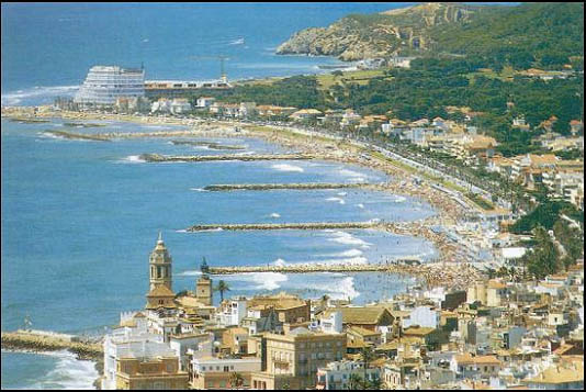
A groyne (British English) or groin (American English; see spelling differences) is a rigid aquatic structure built perpendicularly from an ocean shore (in coastal engineering) or a river bank, interrupting water flow and limiting the movement of sediment. It is usually made out of wood, concrete, or stone. In the ocean, groynes create beaches, prevent beach erosion caused by longshore drift where this is the dominant process and facilitate beach nourishment. There is also often cross-shore movement which if longer than the groyne will limit its effectiveness. In a river, groynes slow down the process of erosion and prevent ice-jamming, which in turn aids navigation.
All of a groyne may be underwater, in which case it is a submerged groyne. They are often used in tandem with seawalls and other coastal engineering features. Groynes, however, may cause a shoreline to be perceived as unnatural. Groynes are generally straight but could be of various plan view shapes, permeable or impermeable, built from various materials such as wood, sand, stone rubble, or gabion, etc.
The term groyne is derived from the Old French groign, from Late Latin grunium, "snout".
A large number of groynes were found along a 1,000-kilometre stretch of the river Nile, between the first and the fourth cataract. The earliest ones dated so far were found to be over 3,000 years old, but researchers are hypothesising that the technique might already have been understood in the fourth millennium BCE. The newly discovered groynes are located in what are now Egypt (Aswan), but mainly in Sudan, in areas of ancient Nubia, some of them built by the Egyptian overlords and some possibly the work of local Nubians.
One of the earliest mentions of groynes is in connection with the planned improvements to the silted-up Dover harbour, by one Fernando Poyntz in 1582.
In 1713 the first wooden groyne to protect Brighton's seafront and coastline was built, which had been heavily damaged in the Great storm of 1703, and again in 1705. In 1867, the first concrete groyne was built near East Street, Brighton as a promenade 195 feet (59 m) long.
A groyne gradually creates and maintains a wide area of beach on its updrift side by trapping the sediments suspended in the ocean current. This process is called accretion of sand and gravel or beach evolution. It reduces erosion on the other, i.e. downdrift, side by reducing the speed and power of the waves striking the shore. It is a physical barrier to stop sediment transport in the direction of longshore drift (also called longshore transport). If a groyne is correctly designed, then the amount of material it can hold will be limited, and excess sediment will be free to move on through the system. However, if a groyne is too large it may trap too much sediment, which can cause severe beach erosion on the down-drift side.
Groynes are generally placed in series, generally all perpendicular to the shore. The areas between groups of groynes are groyne fields.
Hub AI
Groyne AI simulator
(@Groyne_simulator)
Groyne
A groyne (British English) or groin (American English; see spelling differences) is a rigid aquatic structure built perpendicularly from an ocean shore (in coastal engineering) or a river bank, interrupting water flow and limiting the movement of sediment. It is usually made out of wood, concrete, or stone. In the ocean, groynes create beaches, prevent beach erosion caused by longshore drift where this is the dominant process and facilitate beach nourishment. There is also often cross-shore movement which if longer than the groyne will limit its effectiveness. In a river, groynes slow down the process of erosion and prevent ice-jamming, which in turn aids navigation.
All of a groyne may be underwater, in which case it is a submerged groyne. They are often used in tandem with seawalls and other coastal engineering features. Groynes, however, may cause a shoreline to be perceived as unnatural. Groynes are generally straight but could be of various plan view shapes, permeable or impermeable, built from various materials such as wood, sand, stone rubble, or gabion, etc.
The term groyne is derived from the Old French groign, from Late Latin grunium, "snout".
A large number of groynes were found along a 1,000-kilometre stretch of the river Nile, between the first and the fourth cataract. The earliest ones dated so far were found to be over 3,000 years old, but researchers are hypothesising that the technique might already have been understood in the fourth millennium BCE. The newly discovered groynes are located in what are now Egypt (Aswan), but mainly in Sudan, in areas of ancient Nubia, some of them built by the Egyptian overlords and some possibly the work of local Nubians.
One of the earliest mentions of groynes is in connection with the planned improvements to the silted-up Dover harbour, by one Fernando Poyntz in 1582.
In 1713 the first wooden groyne to protect Brighton's seafront and coastline was built, which had been heavily damaged in the Great storm of 1703, and again in 1705. In 1867, the first concrete groyne was built near East Street, Brighton as a promenade 195 feet (59 m) long.
A groyne gradually creates and maintains a wide area of beach on its updrift side by trapping the sediments suspended in the ocean current. This process is called accretion of sand and gravel or beach evolution. It reduces erosion on the other, i.e. downdrift, side by reducing the speed and power of the waves striking the shore. It is a physical barrier to stop sediment transport in the direction of longshore drift (also called longshore transport). If a groyne is correctly designed, then the amount of material it can hold will be limited, and excess sediment will be free to move on through the system. However, if a groyne is too large it may trap too much sediment, which can cause severe beach erosion on the down-drift side.
Groynes are generally placed in series, generally all perpendicular to the shore. The areas between groups of groynes are groyne fields.
Recent media