Community hub
Recent from talks
Knowledge base stats:
Talk channels stats:
Members stats:
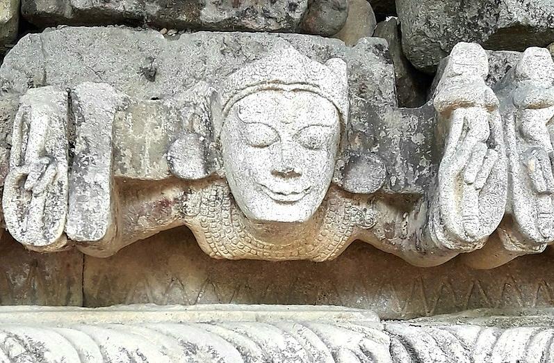
History of Assam
The history of Assam is the history of a confluence of people from the east, west, south and the north; the confluence of the Austroasiatic, Tibeto-Burman (Sino-Tibetan), Tai and Indo-Aryan cultures. Although invaded over the centuries, it was never a vassal or a colony to an external power until the third Burmese invasion in 1821, and, subsequently, the British ingress into Assam in 1824 during the First Anglo-Burmese War.
The Assamese history has been derived from multiple sources. The Ahom kingdom of medieval Assam maintained chronicles, called Buranjis, written in the Ahom and the Assamese languages. History of ancient Assam comes from a corpus of Kamarupa inscriptions on rock, copper plates, clay; royal grants, etc. that the Kamarupa kings issued during their reign. Evidence about the cultural history and socio-religious beliefs of the people of the region can also be derived from the Kalika Purana and the Yogini Tantra, both believed to be composed in this region around the early medieval and medieval times. The religious literature of the Neo-Vaishnavite movement introduced by Sankaradeva are other important primary sources for the region's history.
The history of Assam can be divided into four eras. The ancient era began in the 4th century with the mention of Kamarupa in Samudragupta's inscriptions on the Allahabad pillar and the establishment of the Kamarupa kingdom. The medieval era began with the attacks from the Bengal Sultanate, the first of which took place in 1206 by Bakhtiyar Khilji as mentioned in the Kanai-boroxiboa rock inscription, after the breakup of the ancient kingdom and the sprouting of medieval kingdoms and chieftain-ships in its place. The colonial era began with the establishment of British control after the Treaty of Yandaboo in 1826, and the post-colonial era began in 1947 after the Independence of India.
A common theme of Medieval kingship narratives in Assam is associated with shaktism and the Kamakhya temple.
The earliest inhabitants of the region are assigned to the Middle Pleistocene period (781,000 to 126,000 years ago) in the Rongram valley of Garo Hills. The Paleolithic sites, which used handaxe-cleaver tools, have affinities to the Abbevillio-Acheulean culture. Other Paleolithic sites include those in the Daphabum area of Lohit district in Arunachal Pradesh which used stone tools from metamorphic rocks. The cave-based Paleolithic sites at Khangkhui in Ukhrul, Manipur, are placed in the Late Pleistocene period.
There exists evidence of a microlithic culture in the Rongram Valley of Garo Hills that lie between the Neolithic layers and virgin soil. The microliths here were made of dolerite, unlike those from the rest of India. Shreds of crude hand-made pottery indicate that the microlithic people were hunters and food-gatherers.
Early Neolithic cultures based on the unifacially flaked hand-axe in the Garo hills have developed in line with the Hoabinhian culture, and it is conjectured that this region was the contact point for the Indian and the Southeast Asian cultures.
The Late Neolithic cultures have affinities with the spread of the Mon Khmer speaking people from Malaysia and the Ayeyarwady valley and late Neolithic developments in South China. Since these cultures have been dated to 4500–4000 BCE, the Assam sites are dated to approximately that period.
Hub AI
History of Assam AI simulator
(@History of Assam_simulator)
History of Assam
The history of Assam is the history of a confluence of people from the east, west, south and the north; the confluence of the Austroasiatic, Tibeto-Burman (Sino-Tibetan), Tai and Indo-Aryan cultures. Although invaded over the centuries, it was never a vassal or a colony to an external power until the third Burmese invasion in 1821, and, subsequently, the British ingress into Assam in 1824 during the First Anglo-Burmese War.
The Assamese history has been derived from multiple sources. The Ahom kingdom of medieval Assam maintained chronicles, called Buranjis, written in the Ahom and the Assamese languages. History of ancient Assam comes from a corpus of Kamarupa inscriptions on rock, copper plates, clay; royal grants, etc. that the Kamarupa kings issued during their reign. Evidence about the cultural history and socio-religious beliefs of the people of the region can also be derived from the Kalika Purana and the Yogini Tantra, both believed to be composed in this region around the early medieval and medieval times. The religious literature of the Neo-Vaishnavite movement introduced by Sankaradeva are other important primary sources for the region's history.
The history of Assam can be divided into four eras. The ancient era began in the 4th century with the mention of Kamarupa in Samudragupta's inscriptions on the Allahabad pillar and the establishment of the Kamarupa kingdom. The medieval era began with the attacks from the Bengal Sultanate, the first of which took place in 1206 by Bakhtiyar Khilji as mentioned in the Kanai-boroxiboa rock inscription, after the breakup of the ancient kingdom and the sprouting of medieval kingdoms and chieftain-ships in its place. The colonial era began with the establishment of British control after the Treaty of Yandaboo in 1826, and the post-colonial era began in 1947 after the Independence of India.
A common theme of Medieval kingship narratives in Assam is associated with shaktism and the Kamakhya temple.
The earliest inhabitants of the region are assigned to the Middle Pleistocene period (781,000 to 126,000 years ago) in the Rongram valley of Garo Hills. The Paleolithic sites, which used handaxe-cleaver tools, have affinities to the Abbevillio-Acheulean culture. Other Paleolithic sites include those in the Daphabum area of Lohit district in Arunachal Pradesh which used stone tools from metamorphic rocks. The cave-based Paleolithic sites at Khangkhui in Ukhrul, Manipur, are placed in the Late Pleistocene period.
There exists evidence of a microlithic culture in the Rongram Valley of Garo Hills that lie between the Neolithic layers and virgin soil. The microliths here were made of dolerite, unlike those from the rest of India. Shreds of crude hand-made pottery indicate that the microlithic people were hunters and food-gatherers.
Early Neolithic cultures based on the unifacially flaked hand-axe in the Garo hills have developed in line with the Hoabinhian culture, and it is conjectured that this region was the contact point for the Indian and the Southeast Asian cultures.
The Late Neolithic cultures have affinities with the spread of the Mon Khmer speaking people from Malaysia and the Ayeyarwady valley and late Neolithic developments in South China. Since these cultures have been dated to 4500–4000 BCE, the Assam sites are dated to approximately that period.