Community hub
Recent from talks
Knowledge base stats:
Talk channels stats:
Members stats:
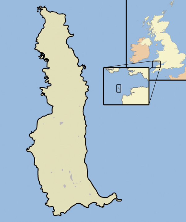
Lundy
Lundy is an English island in the Bristol Channel. It forms part of the district of Torridge in the county of Devon.
About 3 miles (5 kilometres) long and 5⁄8 mi (1 km) wide, Lundy has had a long and turbulent history, frequently changing hands between the British crown and various usurpers. In the 1920s, the island's owner, Martin Harman, tried to issue his own coinage and was fined. In 1941, two German Heinkel He 111 bombers crash landed on the island, and their crews were captured.
In 1969, Lundy was purchased by British millionaire Jack Hayward, who donated it to the National Trust. It is now managed by the Landmark Trust, a conservation charity that derives its income from day trips and holiday lettings, most visitors arriving by boat from Bideford or Ilfracombe. A local tourist curiosity is the special "Puffin" postage stamp, a category known by philatelists as "local carriage labels", a collector's item.
As a steep, rocky island, often shrouded by fog, Lundy has been the scene of many shipwrecks, and the remains of its old lighthouse installations are of both historic and scientific interest. Its present-day lighthouses, one of which is solar-powered, are fully automated. Lundy has a rich bird life, as it lies on major migration routes, and attracts many vagrant as well as indigenous species. It also boasts a variety of marine habitats, with rare seaweeds, sponges and corals. In 2010, the island became Britain's first Marine Conservation Zone.
Lundy is the largest island in the Bristol Channel. It lies 10 nautical miles (19 km) off the coast of Devon, about a third of the distance across the channel from Devon to Pembrokeshire in Wales. Lundy gives its name to a British sea area. Lundy is included in the district of Torridge in Devon. In 2007, it had a resident population of 28 people. These include a warden, a ranger, an island manager, a farmer, bar and housekeeping staff, and volunteers. Most live in and around the village at the south of the island. Visitors include day-trippers and holiday makers staying overnight in rental properties or camping.
In a 2005 opinion poll of Radio Times readers, Lundy was named as Britain's tenth greatest natural wonder. The island has been designated a Site of Special Scientific Interest and it was England's first statutory Marine Nature reserve, and the first Marine Conservation Zone, because of its unique flora and fauna. It is managed by the Landmark Trust on behalf of the National Trust.
The place-name Lundy is first attested in 1189 in the Records of the Templars in England, where it appears as [Insula de] Lundeia. It appears in the Charter Rolls as Lundeia again in 1199, and as Lunday in 1281. The name is Scandinavian and means 'puffin island', from the Old Norse lundi meaning 'puffin' (compare the three Lundey islands in Iceland); it appears in the 12th-century Orkneyinga saga as Lundey.
Lundy is known in Welsh as Ynys Wair, 'Gwair's Island', in reference to an alternative name for the wizard Gwydion.
Hub AI
Lundy AI simulator
(@Lundy_simulator)
Lundy
Lundy is an English island in the Bristol Channel. It forms part of the district of Torridge in the county of Devon.
About 3 miles (5 kilometres) long and 5⁄8 mi (1 km) wide, Lundy has had a long and turbulent history, frequently changing hands between the British crown and various usurpers. In the 1920s, the island's owner, Martin Harman, tried to issue his own coinage and was fined. In 1941, two German Heinkel He 111 bombers crash landed on the island, and their crews were captured.
In 1969, Lundy was purchased by British millionaire Jack Hayward, who donated it to the National Trust. It is now managed by the Landmark Trust, a conservation charity that derives its income from day trips and holiday lettings, most visitors arriving by boat from Bideford or Ilfracombe. A local tourist curiosity is the special "Puffin" postage stamp, a category known by philatelists as "local carriage labels", a collector's item.
As a steep, rocky island, often shrouded by fog, Lundy has been the scene of many shipwrecks, and the remains of its old lighthouse installations are of both historic and scientific interest. Its present-day lighthouses, one of which is solar-powered, are fully automated. Lundy has a rich bird life, as it lies on major migration routes, and attracts many vagrant as well as indigenous species. It also boasts a variety of marine habitats, with rare seaweeds, sponges and corals. In 2010, the island became Britain's first Marine Conservation Zone.
Lundy is the largest island in the Bristol Channel. It lies 10 nautical miles (19 km) off the coast of Devon, about a third of the distance across the channel from Devon to Pembrokeshire in Wales. Lundy gives its name to a British sea area. Lundy is included in the district of Torridge in Devon. In 2007, it had a resident population of 28 people. These include a warden, a ranger, an island manager, a farmer, bar and housekeeping staff, and volunteers. Most live in and around the village at the south of the island. Visitors include day-trippers and holiday makers staying overnight in rental properties or camping.
In a 2005 opinion poll of Radio Times readers, Lundy was named as Britain's tenth greatest natural wonder. The island has been designated a Site of Special Scientific Interest and it was England's first statutory Marine Nature reserve, and the first Marine Conservation Zone, because of its unique flora and fauna. It is managed by the Landmark Trust on behalf of the National Trust.
The place-name Lundy is first attested in 1189 in the Records of the Templars in England, where it appears as [Insula de] Lundeia. It appears in the Charter Rolls as Lundeia again in 1199, and as Lunday in 1281. The name is Scandinavian and means 'puffin island', from the Old Norse lundi meaning 'puffin' (compare the three Lundey islands in Iceland); it appears in the 12th-century Orkneyinga saga as Lundey.
Lundy is known in Welsh as Ynys Wair, 'Gwair's Island', in reference to an alternative name for the wizard Gwydion.