
Community hub
Recent from talks
Contribute something
Nothing was collected or created yet.
Punta Arenas
View on Wikipedia

Key Information


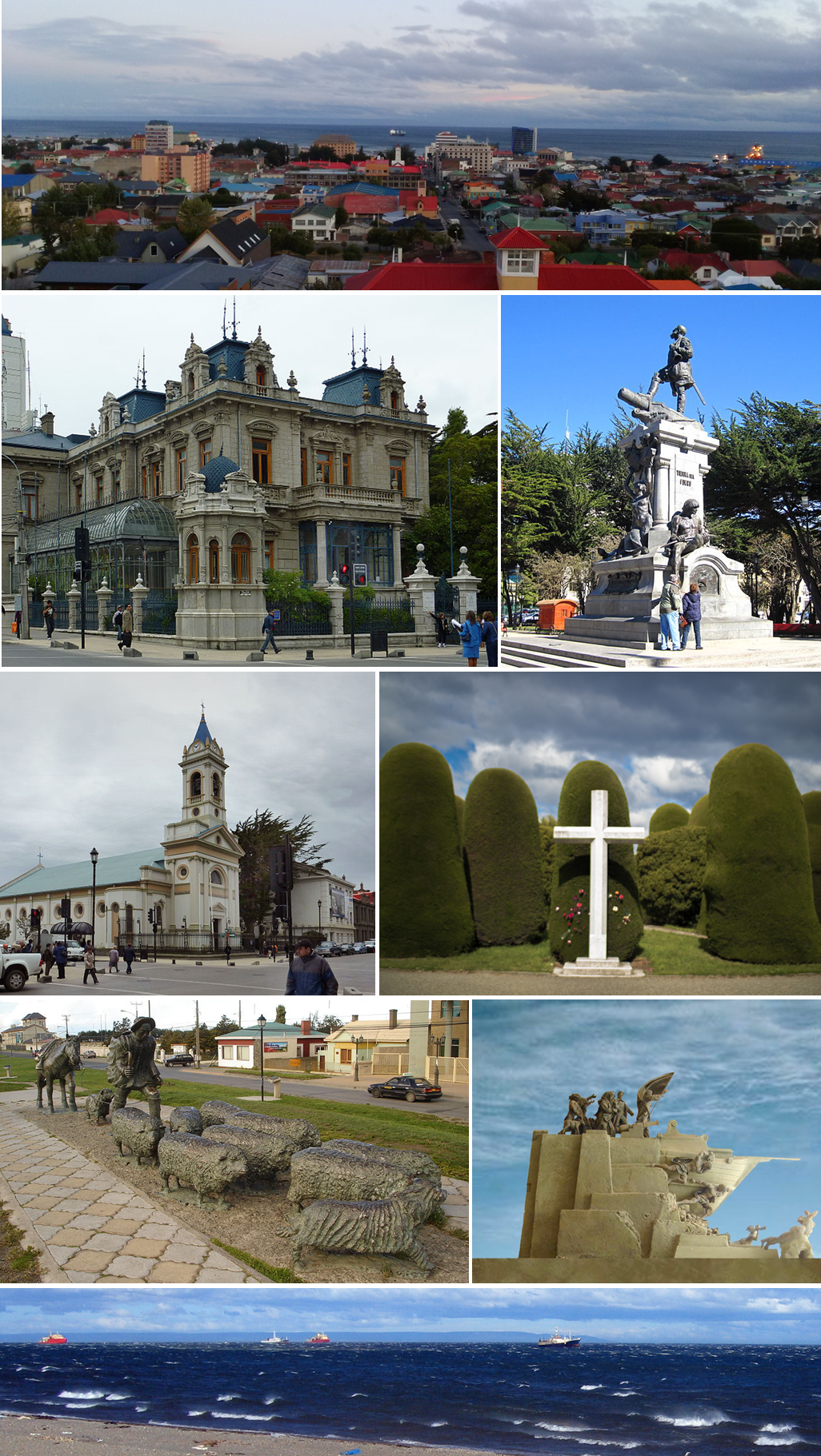
Punta Arenas (Spanish pronunciation: [ˈpunta aˈɾenas], historically known as Sandy Point in English) is the capital city of Chile's southernmost region, Magallanes and Antarctica Chilena. Although officially renamed as Magallanes in 1927, the name was changed back to Punta Arenas in 1938. The city is the largest south of the 46th parallel south and the most populous southernmost city in Chile and the Americas. Due to its location, it is also the coldest coastal city with more than 100,000 inhabitants in Latin America. Punta Arenas is one of the world's most southerly ports and serves as an Antarctic gateway city. Punta Arenas is the world's southernmost city with more than 100,000 inhabitants and claims the title of southernmost city in the world, although that title is also claimed by Ushuaia in Argentina, which lies farther south but is slightly smaller than Punta Arenas.
Since 1977, Punta Arenas has been one of only two free ports in Chile, the other being Iquique in the country's far north.[4][A] Located on the Brunswick Peninsula north of the Strait of Magellan, Punta Arenas was originally established by the Chilean government in 1848 as a small penal colony to assert sovereignty over the Strait. During the remainder of the 19th century, Punta Arenas grew in size and importance due to increasing maritime traffic to the west coasts of South and North America. The city's growth was also due to waves of European immigrants, mainly from Croatia and Russia, attracted by a gold rush, and sheep farming boom in the 1880s and early 20th century. The largest sheep company, which controlled 10,000 square kilometres in Chile and Argentina, was based in Punta Arenas, and its owners lived there.
Since its founding, Chile has used Punta Arenas as a base to defend its sovereignty claims in the southernmost part of South America. That led to the Strait of Magellan being recognized as Chilean territory in the Boundary Treaty of 1881 between Chile and Argentina. Punta Arenas' geopolitical importance has remained high in the 20th and 21st centuries due to its logistic significance in accessing the Antarctic Peninsula.
Since 2017, the city and its region have been on their own time zone, using summer time throughout the year (UTC−3). The city is supplied with water from the San Juan River.[5]
Etymology
[edit]The name Punta Arenas whose literal translation would be "Point Sands", is actually derived from the Spanish term Punta Arenosa, a literal translation of the English name "Sandy Point".
The name Sandy Point derives from the voyage of John Narborough in 1669-1671. He wrote in his account:
Sand-Point [sic] is a mean low Point, lies out more than the other Points of the shore, and a few trees grow on it.[6]
The English 18th-century explorer John Byron is sometimes erroneously credited with naming the area.
The city has also been known as Magallanes. Today that term is normally used to describe the administrative region which includes the city.
Punta Arenas has been nicknamed "the city of the red roofs" for the red-painted metal roofs that characterized the city for many years. Since about 1970, the availability of other colours in protective finishes has resulted in greater variety in the characteristic metal roofs.
Geography
[edit]Located on the Brunswick Peninsula, Punta Arenas is among the largest cities in Patagonia. In 2012, it had a population of 127,454.[7] It is roughly 1,419 km (882 mi) from the coast of Antarctica and 635 km (395 mi) from Ushuaia, the capital of the Argentine province of Tierra Del Fuego.
The Magallanes region is considered part of Chilean Patagonia. Magallanes is Spanish for Magellan, and was named after Ferdinand Magellan, the Portuguese explorer sailing for Spain. While circumnavigating the Earth for Spain, he passed close to the present site of Punta Arenas in 1520. Early English navigational documents referred to this site as "Sandy Point."
The city proper is located on the north-eastern shore of Brunswick Peninsula. Except for the eastern shore, containing the settlements of Guairabo, Rio Amarillo and Punta San Juan, the peninsula is largely uninhabited. The municipality of Punta Arenas includes all of Brunswick Peninsula, as well as all islands west of the Isla Grande de Tierra del Fuego and north of Cockburn and Magdalena channels.
The largest of those are:
- Santa Inés Island
- Desolación Island
- Dawson Island
- Aracena Island
- Clarence Island
- Carlos Island
- Wickham Island
Except Dawson Island, which had a population of about 301 in 2002, the islands are largely uninhabited. Clarence Island had a population of five.
Climate
[edit]
Due to its far southern latitude, Punta Arenas has a subpolar oceanic climate (Köppen climate classification Cfc, Trewartha climate classification Eolk). The seasonal temperature in Punta Arenas is greatly moderated by its proximity to the ocean, with average lows in July near −1 °C (30 °F) and highs in January of 14 °C (57 °F).
It is known for stable constant temperatures, which vary only slightly with the seasons. Rainfall is highest in April and May, and the snowy season runs throughout the Chilean winter (June until September). As in most of Patagonia, average annual precipitation is quite low, only 380 mm (15 in), because of a rain shadow created by the Andes. The average temperature does not go below 1 °C (34 °F).[8] The city is also known for its high winds (up to 130 km/h [81 mph]), which are strongest during the summer. City officials have put up ropes between buildings in the downtown area to assist pedestrians with managing the strong downdrafts.[citation needed]
After 1986, Punta Arenas became the first significantly populated city in the world to be affected directly by the thinning ozone layer. Its residents are considered to be exposed to potentially damaging levels of ultraviolet radiation.[9][10][needs update]
| Climate data for Punta Arenas (1991–2020, extremes 1888–present) | |||||||||||||
|---|---|---|---|---|---|---|---|---|---|---|---|---|---|
| Month | Jan | Feb | Mar | Apr | May | Jun | Jul | Aug | Sep | Oct | Nov | Dec | Year |
| Record high °C (°F) | 25.0 (77.0) |
28.7 (83.7) |
26.0 (78.8) |
22.5 (72.5) |
16.0 (60.8) |
16.0 (60.8) |
12.0 (53.6) |
14.0 (57.2) |
19.0 (66.2) |
23.5 (74.3) |
24.9 (76.8) |
27.0 (80.6) |
28.7 (83.7) |
| Mean daily maximum °C (°F) | 16.3 (61.3) |
16.1 (61.0) |
15.4 (59.7) |
12.1 (53.8) |
8.8 (47.8) |
5.5 (41.9) |
4.9 (40.8) |
7.0 (44.6) |
10.2 (50.4) |
12.9 (55.2) |
14.2 (57.6) |
15.2 (59.4) |
11.6 (52.9) |
| Daily mean °C (°F) | 10.7 (51.3) |
10.3 (50.5) |
8.9 (48.0) |
6.6 (43.9) |
4.2 (39.6) |
1.9 (35.4) |
1.7 (35.1) |
2.7 (36.9) |
4.6 (40.3) |
6.4 (43.5) |
8.3 (46.9) |
9.7 (49.5) |
6.3 (43.3) |
| Mean daily minimum °C (°F) | 5.9 (42.6) |
5.4 (41.7) |
3.9 (39.0) |
2.2 (36.0) |
0.1 (32.2) |
−1.5 (29.3) |
−1.5 (29.3) |
−1.0 (30.2) |
0.0 (32.0) |
0.6 (33.1) |
3.5 (38.3) |
4.8 (40.6) |
1.9 (35.4) |
| Record low °C (°F) | −1.0 (30.2) |
−2.4 (27.7) |
−4.0 (24.8) |
−8.4 (16.9) |
−10.6 (12.9) |
−18.7 (−1.7) |
−14.2 (6.4) |
−12.0 (10.4) |
−9.6 (14.7) |
−4.8 (23.4) |
−3.0 (26.6) |
−1.0 (30.2) |
−18.7 (−1.7) |
| Average precipitation mm (inches) | 38.1 (1.50) |
31.5 (1.24) |
42.9 (1.69) |
45.1 (1.78) |
36.9 (1.45) |
31.3 (1.23) |
30.9 (1.22) |
29.5 (1.16) |
24.5 (0.96) |
24.6 (0.97) |
23.1 (0.91) |
31.8 (1.25) |
390.2 (15.36) |
| Average precipitation days (≥ 1.0 mm) | 8.3 | 7.4 | 8.4 | 8.8 | 7.7 | 6.7 | 7.0 | 7.0 | 5.7 | 5.8 | 6.0 | 7.5 | 86.3 |
| Average relative humidity (%) | 69 | 72 | 75 | 80 | 84 | 86 | 85 | 82 | 77 | 72 | 69 | 69 | 77 |
| Mean monthly sunshine hours | 224.9 | 187.3 | 157.4 | 118.5 | 95.4 | 71.7 | 85.5 | 118.9 | 147.0 | 201.1 | 216.4 | 232.5 | 1,856.6 |
| Source 1: Dirección Meteorológica de Chile[11][12][13] | |||||||||||||
| Source 2: NOAA (precipitation days 1991–2020),[14] Méteo Climat (record highs only)[15] | |||||||||||||
History
[edit]

Two early Spanish settlements were attempted along this coast (on the Straits of Magellan). The first was founded in 1584 and was called Nombre de Jesús. It failed due to the harsh weather and difficulty in the settlers' obtaining food and water, and the enormous distances from other Spanish ports. A second colony, Ciudad del Rey don Felipe, was attempted about 80 kilometres south of Punta Arenas. This became known later as Puerto del Hambre, which translates to Port Famine. Spain had established these settlements in an attempt to protect its shipping and prevent piracy by English pirates, by controlling the Straits of Magellan. An English privateer, Thomas Cavendish, during his circumnavigation, rescued the last surviving member of Puerto del Hambre in 1587.[16][17]
Penal colony
[edit]In 1843 the Chilean government sent an expedition to build a fort and establish a permanent settlement on the shores of the Strait of Magellan. It built and commissioned a schooner called Goleta Ancud which, under the command of John Williams Wilson of the Chilean Navy, transported a crew of 21 people (captain, eighteen crew, and two women), plus cargo, to accomplish the mandate. The founding act of the settlement took place on 21 September 1843.[18]
The fort was well-positioned on a small rocky peninsula, but the location could not support a proper civilian settlement. With that in mind, in 1848, the military governor, José de los Santos Mardones, decided to move the settlement to its current location, along the Las Minas river, and renamed it Punta Arenas.
In the mid-19th century, Chile used Punta Arenas as a penal colony and a disciplinary posting for military personnel with "problematic" behaviour. It also settled immigrants there. In December 1851, a prisoners' mutiny led by Lieutenant Cambiaso, resulted in the murder of Governor Muñoz Gamero and the resident priest, and the destruction of the church and the hospital.[19] The mutiny was put down by Commander Stewart of HMS Virago assisted by two Chilean ships: Indefatigable and Meteoro.[20][21]
In 1867, President José Joaquín Pérez issued a decree offering land grants in an effort to get Chileans or foreigners to settle around Punta Arenas. The first British immigrants arrived in 1867, and their number increased as sheep farming grew in the Chilean Magallanes. The greatest immigration continued to be by the British until 1906, when Croatians surpassed them in numbers.[22]
An 1877 mutiny, known as El motín de los artilleros (Mutiny of the Artillerymen), led to the destruction of a large part of the town and the murder of many civilians not directly associated with the prison. In time the city was restored. The growth of the sheep farming industry and the discovery of gold, as well as increasing trade via sailing ships, attracted many new settlers, and the town began to prosper.
Economic boom
[edit]Between about 1890 and 1940, the Magallanes region became an important sheep-raising region, with one company (Sociedad Explotadora de Tierra del Fuego) controlling over 11,000 square kilometres (4,200 sq mi). In 1910, Sociedad Explotadora merged with Sociedad Ganadera, resulting in a company possessing 3 million hectares in southern Chile and Argentina, with over two million head of sheep.[22]: 120–125 The headquarters of this company and the residences of the owners were in Punta Arenas. The Sarah Braun Museum is now established at the former Braun-Menéndez mansion, in the centre of Punta Arenas.
The Punta Arenas harbour, although exposed to storms, was considered one of the most important in Chile before the construction of the Panama Canal. It was used as a coaling station by the steamships transiting between the Atlantic and Pacific oceans. Today it is mostly used by tourism cruises and scientific expeditions.
Modern city
[edit]The city is often a base for Antarctic expeditions, along with Ushuaia (Argentina) and Christchurch (New Zealand).[23]


Demography
[edit]
| Year | Pop. | ±% p.a. |
|---|---|---|
| 1930 | 26,888 | — |
| 1940 | 33,134 | +2.11% |
| 1952 | 38,106 | +1.17% |
| 1970 | 65,836 | +3.08% |
| 1982 | 100,636 | +3.60% |
| 1992 | 113,666 | +1.22% |
| 2002 | 119,496 | +0.50% |
| 2017 | 131,592 | +0.64% |
| 2024 | 132,363 | +0.08% |
| Source: "Censo de Población y Vivienda". National Statistics Institute. | ||
In 2012 Punta Arenas recorded a population of over 127,000 inhabitants for the (2012 Census) by the National Statistics Institute. The population grew by 5.1% (5,830 persons) between the 1992 and 2002 censuses and further rose to 127,454 at the 2012 Census.[3]
The city was populated by many colonists from Spain and Croatia in the mid-nineteenth century, and many of their descendants remain. Other national ethnic groups represented are German, English, Italian, Swiss and Irish.
Croatian immigration to Punta Arenas was a crucial development in the region of Magallanes and the city in particular. Currently, this influence is still reflected in the names of shops, streets and many buildings. Punta Arenas is said to have the largest percentage of Croatians in the world outside Croatia and the former Yugoslavia.[citation needed]
Punta Arenas also has the largest percentage of residents of British descent in the whole of Chile.[citation needed]
Punta Arenas is home to the southernmost Hindu temple in the world, which is used by the relatively small, but significant, Sindhi community in Punta Arenas. Sindhi merchants began arriving in the area during the early 1900s, and today constitute one of the largest communities of Indians in Chile.[24][25]
Economy
[edit]
By 2006 the economy of Punta Arenas and the region had diversified. Chile's principal oil reserves are close by, along with some low-grade coal.[26][27]
Agricultural production, including sheep and cattle, continues to play a significant role.
Tourism has contributed to the city's economy and steady growth. Tourist destinations include the Cathedral and other notable churches, the city cemetery, and the statue of Magellan. Some cruise ships to Antarctica depart from Punta Arenas's port, which also serves as a hub for many cruise lines that travel along the channels and fjords of the region.[citation needed]
A scheduled ferry service connects Punta Arenas with the main island of Tierra del Fuego, and a less frequent ferry runs to the Chilean town of Puerto Williams.[citation needed]
Education
[edit]University of Magallanes (UMAG) is in the southern Chilean city of Punta Arenas. It is part of the Chilean Traditional Universities. The University of Magallanes was established in 1981 during the neoliberal reforms of Chile's military regime as the successor of Universidad Técnica del Estado's Punta Arenas section. Universidad Técnica del Estado had established the Punta Arenas section in 1961.
The University of Magallanes has campuses in Punta Arenas and Puerto Natales as well as a university centre in Puerto Williams. University of Magallanes publishes the humanities and social sciences journal Magallania twice a year.
There is a German school, Deutsche Schule Punta Arenas.[28]
Culture
[edit]Museums
[edit]- Braun Menéndez Regional Museum (Spanish: Museo Regional Braun Menéndez)
The museum is located in the Braun Menéndez Palace, which is a National Monument. Since February 1983, the "Magallanes Regional Museum" has been operating here, which has material from the contemporary history of the region.
- Salesian Regional Museum Maggiorino Borgatello (Spanish: Museo Regional Salesiano Maggiorino Borgatello)
The museum is located at Avenida Bulnes no. 374, next to the Santuario María Auxiliadora. It is the most important in the area, and has a complete collection of species from the region and the Selkʼnam culture. Samples from Antarctica are also on display. It was created in 1893 by the Salesians religious congregation, and is maintained by voluntary contributions made by the community.
- Naval and Maritime Museum of Punta Arenas (Spanish: Museo Naval y Marítimo de Punta Arenas)
The museum is located at Pedro Montt No. 981, next to the Military Museum. It holds a historical collection of the Chilean Armed Forces during the colonization of the territory of Magallanes and Chilean Antarctica.
- Nao Victoria Museum (Spanish: Museo Nao Victoria)

The museum is located 7.5 km north on Route Y-565 to Rio Seco. This museum exhibits a full-size replica of the first ship ever to circumnavigate the world: Ferdinand Magellan's Nao Victoria.[29] Since October 2011, the museum has displayed a full-size replica of the James Caird, used by Ernest Shackleton during his Imperial Trans-Antarctic Expedition with the Endurance.
- Museum of Remembrance (Spanish: Museo del Recuerdo)

The Museum of Remembrance of the University of Magallanes Instituto de la Patagonia displays examples of heritage buildings, old machinery and tools. They are part of an Open Museum, with high attendance and regional identity and a significant number of foreign visitors, especially during the spring, summer and autumn seasons. It has 8 heritage wooden buildings; 40 antique vehicles and transport of great historical value; machines; and innumerable tools, mainly associated with livestock and oil production.
Administration
[edit]As a "comuna" (commune) Punta Arenas is a third-level administrative division of Chile administered by a municipal council, headed by an alcalde who is directly elected every four years. The 2016–2020 alcalde is Claudio Radonich (National Renewal).[1][2]
Within the electoral divisions of Chile, Punta Arenas is represented in the Chamber of Deputies by Sandra Amar (UDI), Karim Bianchi (IND-PRSD) and Gabriel Boric (CS) as part of the 60th electoral district, which includes the entire Magallanes and Antartica Chilena Region. The commune is represented in the Senate by Carlos Bianchi Chelech (Ind.) and Carolina Goic B. (DC) as part of the 19th senatorial constituency (Magallanes Region).
Transportation
[edit]
Carlos Ibáñez del Campo airport is located 20 kilometers from the city centre. Rental car services, duty-free shops and custom office services are available in the building (there is no duty-free shop in the terminal, despite the representations of tourist literature). Airlines serving the airport include LATAM Chile and Sky Airline, as well as charter flights. The civilian airport and the military airport make up the larger complex.
The city has sea, land, and air connections. By road, a connection to other regions of Chile requires passing through Argentine territory.[8] By sea, several cruises and ferries can take visitors to the city, although the costs are higher because they include stops at tourist sites along the route.
Notable people
[edit]- Gabriel Boric (born 1986), President of Chile (2022–)
- Sara Braun (1862–1955), businesswoman
- María Teresa Castañón (born 1978), politician
- Ana Delfosse (1931–2017), Argentine racing driver and Formula One mechanic
- Marina Latorre (born 1925), writer, journalist and gallerist
- Juan Marino Cabello (1920–2007), composer, writer, screenwriter, bandleader and lyricist
- Mateo Martinic (born 1931), historian and writer
- Mariana Cox Méndez (1871–1914), writer, feminist
- Julio Milostich (born 1966), actor
Twin towns – sister cities
[edit]Punta Arenas is twinned with:[30]
 Bellingham, United States
 Harbin, China[31]
 Río Gallegos, Argentina
- Ushuaia, Argentina.
See also
[edit]Notes
[edit]- ^ Punta Arenas itself is not a "free port": Outside the city there is a "zona franca" where certain products can be imported into the country under a reduced-tax regime.
References
[edit]- ^ a b "Asociación Chilena de Municipalidades" (in Spanish). Archived from the original on 28 June 2011. Retrieved 27 January 2011.
- ^ a b "Municipality of Punta Arenas" (in Spanish). Archived from the original on 28 June 2011. Retrieved 27 January 2011.
- ^ a b c d "National Statistics Institute" (in Spanish). Archived from the original on 20 December 2010. Retrieved 27 January 2010.
- ^ "Zona franca de Aysén tendrá características similares a las de Iquique y Punta Arenas" [Aysén free zone will have characteristics similar to those of Iquique and Punta Arenas]. La Tercera (in Spanish). 1 April 2012. Archived from the original on 22 April 2014.
- ^ "Hidrografía Región de Magallanes". bcn.cl (in Spanish). Biblioteca del Congreso Nacional de Chile. Retrieved 2 March 2022.
- ^ Edmundson, William (2009). A History of the British Presence in Chile: From Bloody Mary to Charles Darwin and the Decline of British Influence. Springer. p. 115. ISBN 9780230101210. Retrieved 3 July 2019.
- ^ "Interactive map, INE Census 2002, Chile". ine.cl. Archived from the original on 20 November 2006. (Click on XII Region and then on Punta Arenas)
- ^ a b "Punta Arenas". Letsgochile.com. Archived from the original on 27 February 2009.
- ^ Sims, Calvin (3 March 1995). "Punta Arenas Journal; A Hole in the Heavens (Chicken Little Below?)". The New York Times. Archived from the original on 10 May 2013. Retrieved 16 May 2012.[needs update][needs update]
- ^ Abarca, Jaime F; Casiccia, Claudio C. (9 December 2002). "Skin cancer and ultraviolet-B radiation under the Antarctic ozone hole: southern Chile, 1987–2000". Photodermatology, Photoimmunology & Photomedicine. 18 (6). John Wiley & Sons A/S: 294–302. doi:10.1034/j.1600-0781.2002.02782.x. PMID 12535025. S2CID 25748826.
Abstract.
"Background: Punta Arenas, Chile, the southernmost city in the world (53°S),
with a population of 154,000."[needs update][needs update] - ^ "Datos Normales y Promedios Históricos Promedios de 30 años o menos" (in Spanish). Dirección Meteorológica de Chile. Archived from the original on 27 May 2023. Retrieved 27 May 2023.
- ^ "Datos Normales y Promedios Históricos Promedios de 30 años o menos" (in Spanish). Dirección Meteorológica de Chile. Archived from the original on 27 May 2023. Retrieved 27 May 2023.
- ^ "Estadistica Climatologica Tomo III" (PDF) (in Spanish). Dirección General de Aeronáutica Civil. March 2001. pp. 512–37. Archived from the original (PDF) on 20 October 2017. Retrieved 15 January 2013.
- ^ "Carlos Ibanez Aeropuerto Punta Arenas Climate Normals 1991–2020". World Meteorological Organization Climatological Standard Normals (1991–2020). National Oceanic and Atmospheric Administration. Archived from the original on 4 August 2023. Retrieved 4 August 2023.
- ^ "Station Punta Arenas". Méteo Climat. Retrieved 10 February 2015.
- ^ Martinic, Mateo, (2000) Rey don Felipe: Historical facts (in Spanish). Productora Gráfica Andros Ltda, 100 p. http://www.memoriachilena.cl/602/w3-article-10388.html Archived 4 March 2016 at the Wayback Machine
- ^ Moss, Chris, (2008). Patagonia: A cultural History. Oxford University Press, New York, 299 p.
- ^ Braun-Menéndez, Armando (1968). Fuerte Bulnes: Colección Cruz del Sur; 10 (in Spanish) (2nd ed.). Francisco de Aguirre.
- ^ "Punta Arenas, History and Legends". Interpatagonia.com. Archived from the original on 19 April 2012. Retrieved 16 May 2012.
- ^ "History HMS Virago". Pdavis.nl. Archived from the original on 15 April 2012. Retrieved 16 May 2012.
- ^ "Brown, Charles H., "Insurrection at Magellan. Narrative of the Imprisonment and Escape of Capt. Chas. H. Brown," Chilian Convicts" (Second ed.). Boston: hosted at Patlibros.org. Geo. C. Rand. 1854. Archived from the original on 8 February 2012. Retrieved 16 May 2012.
- ^ a b Edmundson, William (2009). A History of the British Presence in Chile: From Bloody Mary to Charles Darwin and the Decline of British Influence. New York: Palgrave MacMillan. pp. 117-125. ISBN 9780230114838.
- ^ Punta Arenas example Archived 19 February 2008 at the Wayback Machine
Ushuaiaexample Archived 19 February 2008 at the Wayback Machine
Ushuaiaexample Archived 8 February 2008 at the Wayback Machine
Ushuaiaexample Archived 20 February 2008 at the Wayback Machine
"New Zealand is still the jumping-off point for today's expeditions to Antarctica, and the home of several Antarctic research institutes." , BBC News
"Christchurch... is still the major jumping off point for Antarctica. It hosts the International Antarctic Centre, a place well worth a visit." Archived 19 February 2008 at the Wayback Machine, Pacific Island Books - ^ "Keeping cultures alive: Sindhis and Hindus in Chile". Hindustan Times. 2 August 2015. Retrieved 30 December 2021.
- ^ Haksar, Nandita. "Punta Arenas: Did you know of the Chilean town where a Sindhi man set up a business outpost in 1905?". Scroll.in. Retrieved 30 December 2021.
- ^ Política Enérgetica Magallanes y Antártica Chilena 2050 (PDF) (Report) (in Spanish). 2017. p. 17. Retrieved 13 June 2022.
- ^ Hackley, Paul C.; Warwick, Peter D.; Alfaro, Guillermo H.; Cuebas, Rosenelsy M. (2006). "World Coal Quality Inventory: Chile" (PDF). World Coal Quality Inventory: South America (Report). USGS. pp. 90–131. Retrieved 23 February 2017.
- ^ "Deutscher Bundestag 4. Wahlperiode Drucksache IV/3672" (Archive). Bundestag (West Germany). 23 June 1965. Retrieved 12 March 2016. p. 23/51.
- ^ "Museum website". Naovictoria.cl. Archived from the original on 7 February 2012. Retrieved 16 May 2012.
- ^ "Estadísticas e Información Territorial de la Comuna de Punta Arenas". puntaarenas.cl (in Spanish). Punta Arenas. Retrieved 20 December 2021.
- ^ "哈尔滨市". hljswb.gov.cn (in Chinese). Heilongjiang Provincial People's Government. Retrieved 20 December 2021.
External links
[edit]- portal de la ciudad
- Portal de la Ciudad
- Municipalidad de Punta Arenas
- La Prensa Austral
- Satellite picture by Google Maps
Communes and municipalities in Magallanes y la Antártica Chilena Region | ||
|---|---|---|
| Última Esperanza |  | |
| Magallanes | ||
| Tierra del Fuego | ||
| Antártica Chilena | ||

| International | |
|---|---|
| National | |
| Geographic | |
| Other | |
Punta Arenas
View on GrokipediaGeography
Location and Topography
Punta Arenas is situated on the Brunswick Peninsula along the northern shore of the Strait of Magellan in southern Chile, at coordinates 53°09′S 70°55′W.[11][12] This positioning places it as the southernmost city on the mainland of South America, with Cape Froward, the continent's southernmost point, located approximately 100 km to the south.[2][13] The city occupies coastal plains at an elevation of 38 meters above sea level, enabling a grid-like urban layout adapted to the relatively flat terrain bordering the strait.[14] The Strait of Magellan, a 570-kilometer navigable passage separating mainland South America from Tierra del Fuego and numerous islands, underscores the site's strategic importance for interoceanic trade routes historically alternative to the Drake Passage.[13] Surrounding landforms include subantarctic pampas extending inland to support expansive estancias, while to the west, the terrain transitions into forested hills and Andean foothills with fjords indenting the Pacific coastline further north.[15][9] The immediate vicinity features low-relief coastal zones prone to strong winds, shaping settlement patterns around sheltered bays and the strait's protected waters.Climate and Environmental Conditions
Punta Arenas features a subpolar oceanic climate (Köppen Cfc) marked by cool, stable temperatures, persistent strong winds, and moderate precipitation levels that support habitability despite environmental rigors. The average annual temperature stands at approximately 6°C, with monthly means ranging from 2°C in July to 9°C in January; summer highs seldom surpass 15°C, while winter lows average -2°C and rarely drop below -5°C.| Month | Avg. Max (°C) | Mean (°C) | Avg. Min (°C) | Avg. Precip. (mm) |
|---|---|---|---|---|
| Jan | 12 | 9 | 6 | 38 |
| Feb | 12 | 8 | 5 | 32 |
| Mar | 11 | 7 | 4 | 37 |
| Apr | 9 | 6 | 3 | 42 |
| May | 7 | 4 | 1 | 52 |
| Jun | 4 | 2 | -1 | 48 |
| Jul | 4 | 2 | -1 | 41 |
| Aug | 5 | 2 | -1 | 37 |
| Sep | 7 | 3 | 0 | 29 |
| Oct | 9 | 5 | 1 | 32 |
| Nov | 11 | 6 | 2 | 37 |
| Dec | 11 | 7 | 4 | 40 |
History
Indigenous Presence and Early European Exploration
The Strait of Magellan region, encompassing the area later known as Punta Arenas, was sparsely populated by nomadic hunter-gatherer groups prior to European arrival, primarily the Selk'nam (also called Ona), who inhabited terrestrial zones north of the strait focused on guanaco hunting, and maritime nomads including the Kawésqar (Alacaluf) along coastal and island channels.[22][23] These societies maintained low population densities—estimated at 3,700 to 3,900 for the Kawésqar across their range before widespread contact, with Selk'nam figures similarly in the low thousands—due to the region's ecological limitations, such as minimal vegetative biomass, short growing seasons, and reliance on unpredictable marine and terrestrial prey without domesticated crops or herds.[24] Archaeological evidence from South Patagonian sites confirms long-term adaptation to these constraints, with no indications of surplus-supporting technologies that could sustain higher numbers, underscoring carrying capacity as the binding factor rather than cultural choices.[25] Ferdinand Magellan's Spanish-Portuguese expedition first navigated the strait in 1520, entering the passage on October 21 after 38 days of scouting amid hostile weather and limited native interactions, primarily fleeting canoe sightings but no sustained engagements or settlements. Subsequent voyages, such as Francis Drake's 1578 circumnavigation, traversed southern Patagonian waters and the strait but prioritized plunder and mapping over colonization, with explorer accounts noting the Tehuelche-related "giants" (likely exaggerated descriptions of tall nomads) yet confirming the absence of fixed European outposts.[26] These early probes introduced indirect demographic pressures through inadvertent disease transmission—pathogens like measles and influenza, absent prior immunity among isolates—initiating collapses that archaeological and genetic records link to post-16th-century morbidity spikes in skeletal populations.[27] By the 19th century, when permanent settlements emerged, native numbers had plummeted over 90% from pre-contact baselines, with diseases acting as the dominant vector per pathogen modeling and contact-era logs, augmented by episodic sealers' violence but not dependent on it for scale.[25][28]Penal Colony Foundation and Settlement
Punta Arenas originated as a strategic outpost in Chile's efforts to assert sovereignty over the Strait of Magellan amid competing Argentine and British territorial interests in the mid-19th century. In 1843, President Manuel Bulnes ordered the establishment of Fuerte Bulnes, the first permanent Chilean settlement on the strait, commanded by a military contingent to enforce national claims and monitor navigation.[29][15] Conditions proved harsh, prompting relocation to a more viable site at Punta de Arenillas (later Punta Arenas) in 1848 under Governor José de los Santos Mardones, who formally founded the settlement on December 18 as a naval base and penal colony.[30][31] Initial construction relied on convict labor, with prisoners erecting fortifications, barracks, a church, and basic infrastructure to support military presence and deter foreign encroachment.[32] The penal colony's operations emphasized disciplinary control, housing convicts and military personnel deemed problematic, which facilitated rapid infrastructural development despite the region's extreme weather and isolation. By the early 1850s, the settlement housed around 200 inhabitants, including soldiers, settlers, and inmates tasked with woodcutting, farming rudimentary plots, and maintaining defenses. A significant challenge arose in November 1851 during the Mutiny of Cambiazo, led by naval officer José Miguel Cambiazo—a supporter of liberal rebels in Chile's contemporaneous civil war—where convicts and mutineers seized control, burned buildings, and attempted piracy before Chilean naval forces suppressed the uprising, executing leaders and restoring order.[33][34] This enforcement of authority underscored the state's coercive mechanisms as essential for sustaining habitation in an otherwise untenable environment, preventing collapse and enabling gradual expansion. By the late 1860s, the penal character waned as Chile shifted toward incentivized colonization to bolster population and permanence. President José Joaquín Pérez's 1867 policy granted land to ex-convicts who demonstrated good conduct and to incoming immigrants, transforming the outpost into a self-sustaining civilian community rather than a mere prison.[5] This transition, combining forced labor's initial outputs with voluntary settlement incentives, laid the groundwork for demographic stability, with pardoned inmates receiving plots averaging 100 hectares to cultivate amid the treeless pampas, though success hinged on imported resources and state subsidies.[32]Sheep Farming Boom and Economic Expansion
The introduction of sheep to the Magallanes region by private settlers, including José Menéndez who initiated operations in 1876, marked the onset of large-scale pastoralism driven by entrepreneurial initiative rather than government directives.[35] Menéndez, alongside other immigrants, established expansive estancias suited to the Patagonian grasslands, capitalizing on global demand for wool amid Europe's industrial expansion.[36] This private-led expansion attracted voluntary waves of European laborers, particularly from Croatia, Britain, and Spain, who provided skilled management and scaling of herds through selective breeding and herding techniques.[37] [38] By the early 1900s, the region's sheep population exceeded two million head, with enterprises like the Sociedad Explotadora de Tierra del Fuego growing from under 7,000 animals in 1893 to over two million by 1910 through market-oriented investments in fencing, water management, and working dogs adapted from Scottish breeds.[39] These operations concentrated wealth among a few magnates but relied on wage labor from migrants seeking economic opportunity, countering narratives of systemic coercion by evidencing self-selected participation in a high-risk, high-reward frontier economy.[36] Magallanes estancias supplied a dominant share of Chile's wool output, fueling Punta Arenas' transformation into a processing and export nexus.[35] Punta Arenas emerged as the primary hub for wool shipments to European textile markets, with peak export values reflecting unhampered trade flows rather than subsidized infrastructure.[38] Private shipping firms expanded port facilities to handle baled wool, accommodating steamers bound for Britain and Germany, while rudimentary rail lines connected inland estancias to the harbor in response to commercial pressures.[40] This market-driven development amplified local prosperity, as wool revenues financed urban growth and immigrant remittances without reliance on state fiscal support.[36]20th-Century Transitions and Resource Shifts
The collapse of international wool markets after World War I, exacerbated by oversupply and competition from producers like Australia and Argentina, diminished the dominance of sheep farming in the Magallanes region, necessitating economic diversification.[41] Local efforts shifted toward guano extraction from island deposits and timber harvesting from native forests, providing interim revenue streams amid fluctuating agricultural prices.[42] A pivotal transition occurred with oil discoveries in the Magallanes Basin during the 1940s, beginning with a significant find on December 29, 1945, which enabled commercial extraction starting in 1949.[43] The Chilean government established the state-owned Empresa Nacional del Petróleo (ENAP) on June 19, 1950, to oversee prospecting, production, and refining, initially focusing on the region's hydrocarbon reserves that supplied much of the nation's oil until the 1960s.[44] These developments drove a mid-century population influx to Punta Arenas, with urban expansion fueled by oil-related jobs and infrastructure investments, sustaining the city's role as a regional hub despite broader national economic volatility.[44] The fishing sector emerged as another key diversifier, with industrial fleets targeting hake (Merluccius gayi) and jumbo squid (Dosidicus gigas) in southern waters, leading to rapid catch expansions through the 1970s and 1980s as demand grew for exports.[45] However, overexploitation became evident by the late 1980s, as unregulated effort increases depleted stocks—hake landings, for instance, foreshadowing sharper declines into the 1990s—and exposed regulatory shortcomings in balancing short-term market incentives against long-term sustainability.[46] Under the 1973–1990 military regime, neoliberal reforms including privatizations and market-oriented policies in resource sectors enhanced efficiency through measures like individual transferable quotas in fisheries and streamlined concessions, boosting productivity in oil and fishing operations.[47] Yet these changes sparked ongoing debates about equity, as concentrated ownership reduced opportunities for small-scale operators and widened income disparities, with critics attributing persistent regional inequalities to the prioritization of aggregate growth over inclusive distribution.[48][49]Post-2000 Developments and Geopolitical Role
The port of Punta Arenas has seen modernization efforts, including a $400 million, five-year investment program signed by President Gabriel Boric in November 2023 to upgrade regional ports and infrastructure, enabling handling of larger vessels amid global shipping shifts.[50] Concurrently, Presidente Carlos Ibáñez del Campo International Airport has undergone expansions, with works advancing in 2024 to triple its surface area by 2030 through added boarding bridges, cargo terminals, and parking facilities to support increased Antarctic and commercial traffic.[51] As the base for the Instituto Antártico Chileno (INACH), Punta Arenas administers Chile's Antarctic scientific programs under the Antarctic Treaty System, coordinating research logistics and compliance with international protocols prohibiting territorial claims while advancing empirical studies in biology, geology, and climate.[52] The city facilitated over 170 cruise ship calls in the 2024 season, predominantly Antarctic expedition vessels departing from its terminals, reflecting a surge in polar tourism logistics.[53] Punta Arenas' strategic position has drawn geopolitical focus, with the Strait of Magellan serving as an alternative route for vessels rerouted from the drought-restricted Panama Canal in 2023-2024, potentially boosting throughput for larger cargo amid persistent water constraints.[54] Renewed U.S. and Chinese interest in 2024 centers on green hydrogen initiatives, exploiting Magallanes' high winds for electrolysis projects like HNH Energy's wind farm developments, positioning the port as a nexus for energy exports and Antarctic supply chains in great-power competition.[44] The COVID-19 period highlighted regional self-reliance, as salmon exports from southern Chile sustained economic flows despite global disruptions, bolstered by remote operational adaptations in isolated facilities.[55]Demographics
Population Trends and Growth Patterns
The population of Punta Arenas experienced rapid growth during the late 19th and early 20th centuries, driven primarily by European and Chilean immigration tied to the sheep farming boom, expanding from a small penal colony settlement of fewer than 2,000 residents around 1900 to over 30,000 by mid-century through successive waves of settlers attracted by land grants and economic opportunities.[56] By the 2002 census, the comuna's population reached 119,496, reflecting steady but decelerating expansion as resource-based booms waned.[57]| Year | Comuna Population | Annual Growth Rate (approx.) | Source |
|---|---|---|---|
| 2002 | 119,496 | - | Chilean Census via Municipal Report[57] |
| 2012 | 125,483 | 0.50% | Chilean Census via Municipal Report[57] |
| 2017 | 131,592 | 0.97% | Chilean Census via BCN[58] |
| 2023 | ~145,713 (proj.) | 1.77% (proj.) | INE Projections via BCN[58] |
| 2024 | 132,363 (prelim. city) | <0.5% (est.) | Preliminary Census Report[2] |
Ethnic Composition and Immigration History
The ethnic composition of Punta Arenas reflects extensive European immigration during the late 19th and early 20th centuries, driven by the region's sheep farming expansion and colonization incentives established in 1867.[5] Genetic analysis of local residents indicates an average admixture of 56.5% European ancestry, with the remainder comprising Native American components (11.3% northern and 28.6% south-central), underscoring the demographic impact of settler inflows over indigenous baselines.[65] These European contributions, rather than indigenous continuity, formed the core of the city's human capital, with immigrants integrating through land grants for estancias and resource extraction ventures. Croatian descendants, mainly from Dalmatia, constitute one of the largest specific European subgroups, with estimates indicating up to 50% of Punta Arenas' population tracing ancestry to these arrivals who began settling in the 1870s for ranching and gold mining opportunities.[66] This wave peaked around the 1880s-1900s amid economic booms, as Croatian laborers and entrepreneurs filled labor shortages in vast Patagonian holdings.[67] Other Europeans, including British sheep farming experts who introduced breeds and management practices, Spaniards via colonial ties, and smaller contingents of Germans, Italians, Swiss, and Irish, further diversified the settler base, often through family-based enterprises tied to wool exports.[68] Indigenous Tehuelche and related groups represent a negligible fraction today (<1% in regional self-identification surveys), with their demographic remnants overshadowed by admixture and historical attrition, contrasting sharply with higher Mapuche proportions in central Chile.[69] Cultural preservation among immigrants emphasizes European heritage, as seen in the Croatian Club of Punta Arenas (established early 20th century), which sustains Dalmatian traditions, festivals, and mutual aid networks without significant reliance on state multiculturalism programs.[70] National census data from Chile's Instituto Nacional de Estadísticas reveal low ethnic self-identification diversity pressures in Magallanes, with over 95% reporting Spanish as primary language and integration occurring via market participation in ranching and trade rather than parallel communities.[66] This pattern aligns with the region's isolation, fostering assimilation over sustained multiculturalism.Economy
Resource Extraction and Primary Industries
The Magallanes Basin, underlying the Punta Arenas region, constitutes Chile's principal onshore hydrocarbon province, with state-owned Empresa Nacional del Petróleo (ENAP) dominating exploration and production activities. Natural gas output from fields such as Arenal supports regional energy needs, supplemented by oil production estimated at around 20,000 barrels per day historically, though recent focus has shifted toward gas enhancement via partnerships introducing advanced compression technologies installed deep in wells to boost recovery rates. ENAP's 2024 tender for $580 million in oilfield services underscores ongoing efforts to sustain operations through 2027, amid national reserves of approximately 90 million barrels of oil equivalent as of late 2024. These activities contribute 13-15% to the regional GDP, representing 40-50% of the area's mining sector value added.[71][72][73][74] Fishing and aquaculture form another pillar, with regulated quotas governing wild capture species like Patagonian toothfish and hake, generating over $500 million annually in regional exports when combined with farmed output. Magallanes participates in Chile's national aquaculture sector, which produced 1.46 million tonnes in 2024, including salmon contributions that bolster the region's economy despite stricter southern zoning limiting expansion. Aquaculture alone accounts for about 7.9% of Magallanes' GDP, with individual transferable quotas (ITQs) since the 1990s enhancing efficiency by allocating rights based on historical catches, reducing overfishing incentives compared to open-access regimes. However, environmental regulations, including those on salmon farm relocations, have constrained growth, prompting critiques of bureaucratic delays in permitting that elevate compliance costs and deter investment.[75][76] Sheep farming, historically dominant, has contracted to approximately 1 million head in Magallanes, representing over 50% of Chile's national flock and 80% of its sheep meat production, with emphasis shifting to premium merino wool yields per animal amid declining overall numbers due to labor shortages and market pressures. This sector sustains exports of high-value fine wool, though its GDP share has diminished as hydrocarbons and fisheries expanded. Private operators have adopted rotational grazing and breed improvements for resilience, yet state-influenced land use policies and overregulation—such as stringent environmental impact assessments—have been faulted for hampering productivity, with recent government reforms targeting 30-70% reductions in permitting timelines to alleviate such frictions without compromising standards. ENAP's collaborations with private entities exemplify how introducing competitive elements post-monopoly eras correlates with measurable gains in extraction metrics, contrasting with periods of state exclusivity that correlated with stagnant innovation in output per well.[77][78][79][72]Maritime Trade and Port Economy
The Port of Punta Arenas functions as a key waypoint for merchant vessels navigating the Strait of Magellan, offering a safer and often faster alternative to the Cape Horn route or the Panama Canal for interoceanic trade, particularly amid disruptions like the 2023-2024 Panama Canal drought that reduced transits by over 30%. In 2022, the strait accommodated 2,831 major vessel transits, with traffic rising 25% in early 2024 compared to the prior year, driven by rerouted cargo from congested global chokepoints.[80][44] This positioning has boosted ancillary services, including fuel bunkering, where suppliers like Copec deliver marine fuels via ship-to-ship operations to over 1,000 vessels annually across southern Chilean ports, enhancing efficiency for trans-strait passages.[81] Cargo handling at the port, managed by Empresa Portuaria Austral across terminals like Arturo Prat and José de los Santos Mardones, totaled 663,795 tons in 2024, encompassing breakbulk, containers (up to 13,000 TEU historically), and specialized loads, though this marked a decline amid fluctuating global demand.[82] These volumes underscore the port's integration into broader trade flows, with economic multipliers evident in logistics employment; the sector supports specialized roles in stevedoring and supply chain management, generating sustained local revenue without reliance on heavy subsidies seen in competing routes. Ship repair capabilities further amplify this, via the ASMAR Magallanes yard—established in 1896—which handles maintenance, modernization, and conversions for vessels up to 142 meters in length, serving both commercial and naval clients along South America's western coast.[83] Strategic infrastructure upgrades aim to accommodate larger vessels, including over US$41 million invested in 2024 for cranes, berths, and logistics enhancements to improve throughput and competitiveness. In the geopolitical context, 2024 saw heightened bids from the United States and China for port-related investments, framed by Chilean authorities as bolstering national sovereignty over the strait amid rising Antarctic logistics and green energy prospects, though such overtures reflect competitive great-power dynamics rather than altruism.[44] These developments position the port as a linchpin for resilient supply chains, with transit efficiencies directly correlating to reduced fuel costs and delays for Asia-Europe or Americas trade legs.Tourism, Antarctic Logistics, and Emerging Sectors
Punta Arenas serves as a gateway for tourism centered on wildlife viewing and maritime excursions, with key attractions including boat tours to Magdalena Island for observing Magellanic penguin colonies and navigation through the Strait of Magellan.[84] [85] These day trips, operating primarily from September to March, draw visitors to the island's lighthouse and breeding grounds hosting thousands of penguins.[86] Cruise ship traffic underpins much of the sector's volume, with the port recording 76,537 passengers in the 2023/24 season across numerous calls.[87] Projections for the 2024 season anticipate approximately 170 cruise arrivals and 100,000 visitors, reflecting recovery from pandemic disruptions and reliance on seasonal southern hemisphere summer operations.[53] This influx provides revenue diversification, though it generates employment volatility tied to peak periods, with infrastructure maintenance costs often understated in promotional narratives.[53] As an Antarctic logistics hub, Punta Arenas facilitates expeditions through its port and airport, supporting research vessels like the Laurence M. Gould and commercial operators such as Antarctica21, which bases fly-cruise itineraries there.[88] [89] The city handles cargo, personnel transfers, and vessel departures for the continent, contributing to Chile's Antarctic claims under the Treaty system, with private firms driving efficiency amid state-supported infrastructure. Emerging sectors leverage the region's persistent winds for renewable energy, notably green hydrogen production via electrolysis powered by onshore wind farms. Projects include Enel Green Power's industrial-scale plant, operational since 2021, and H2 Magallanes' ammonia facility using wind-derived hydrogen.[90] [91] EDF's initiative, advancing as of 2025, targets decarbonization exports, with private investments signaling calculated returns based on local wind speeds exceeding 10 m/s annually.[92] These developments offer long-term diversification, contrasting tourism's seasonality, though scalability hinges on verifiable global market demand rather than subsidized hype.[93]Economic Challenges and Policy Critiques
The remote geography of Punta Arenas, situated at the southern tip of mainland South America, results in elevated logistics costs that add a substantial premium to the price of imported goods and hinder export efficiency, with freight and warehousing markets in Chile reflecting broader challenges in southern regions where transport distances amplify expenses.[94] This structural barrier contributes to a less-developed economy compared to central Chile, fostering dependency on volatile primary exports such as petroleum gas, which accounted for a major share of the region's $367 million in exports in 2024.[95] Such reliance exposes local growth to global commodity cycles, including oil price swings, while national inflation—reaching 11.64% in 2022 amid post-pandemic supply disruptions and fiscal policies—has intensified cost-of-living pressures in isolated areas like Magallanes, where imported essentials face compounded markups.[96] Regional GDP per capita in Magallanes lags behind Santiago's metropolitan levels, with disparities underscoring barriers to diversification; while national figures hovered around $14,500 in 2024, southern resource-dependent areas struggle with lower productivity outside extractives, prompting outflows of skilled labor to urban centers for better opportunities—a pattern observed in Chile's Southern Cone emigration trends.[97] Policy critiques highlight how rigid national labor laws, mandating high minimum wages and extensive protections without adjustments for remote-area labor scarcity, inflate operational costs and deter investment in labor-intensive sectors.[98] Environmental permitting processes have notably delayed infrastructure and energy projects in Magallanes, as evidenced by TotalEnergies' 2025 request to suspend assessment of its $16 billion green ammonia initiative due to protracted regulatory hurdles, despite the project's alignment with decarbonization goals.[99] Similarly, salmon farming expansions in southern channels, including near Punta Arenas, have faced court-ordered permit revocations over environmental concerns, such as in the 2023 annulment of Australis Seafoods' Obstrucción center approval, stalling production cycles and investment.[100] The OECD has critiqued Chile's cumbersome local legal procedures for impeding economic activity, arguing that excessive regulatory layers—often justified by precautionary environmental standards—prioritize process over outcomes, exacerbating remoteness penalties without commensurate benefits.[101] Advocates for market-oriented reforms contend that deregulation, including streamlined permitting and flexible labor adjustments, would better address these causal frictions by enhancing competitiveness and reducing reliance on central subsidies, drawing on evidence from faster-approving jurisdictions that achieve higher regional growth.[102]Government and Administration
Local Governance Structure
Punta Arenas operates as a municipality (comuna) under Chile's decentralized local government framework, with executive authority vested in a mayor elected by direct popular vote for a four-year term, renewable consecutively. The legislative body is the municipal council (concejo municipal), comprising eight councilors also elected every four years to approve budgets, ordinances, and oversee administration.[103] This structure aligns with national law scaling council size to population, which for Punta Arenas' approximately 131,000 residents justifies the current eight seats following 2024 electoral adjustments.[104] The municipal budget for 2025 totals 71 billion Chilean pesos (roughly US$75 million at prevailing exchange rates), reflecting an 8% reduction from 2024 due to fiscal constraints and national subsidy adjustments.[105] Primary funding sources include national transfers such as the Fondo Común Municipal (accounting for over 70% of revenues in similar Chilean communes) and local own-source revenues like property taxes (patente municipal) and service fees, though direct port fees accrue more to regional entities via the Zona Franca de Punta Arenas rather than the municipality.[106] [107] Budget execution emphasizes operational spending on public services, with accountability enforced through annual public accounts and Contraloría General audits, though execution rates hover around 90% amid challenges like desmunicipalized education costs transferred to the state.[108] Administrative operations face critiques of inefficiency stemming from Chile's centralized system, where Santiago-based ministries retain veto power over regional zoning, infrastructure approvals, and fiscal allocations, limiting local autonomy in Magallanes.[109] For instance, municipal zoning policies, outlined in the Plan de Desarrollo Comunal (PLADECO) and Plan Regulador Comunal, prioritize urban expansion and port-adjacent land use but require national environmental and territorial approvals, delaying projects by 12-24 months on average.[110] Service delivery metrics, such as waste collection coverage exceeding 95% and basic health access via CESFAM centers serving 80% of the population, demonstrate competence, yet voter turnout in 2024 municipal elections—around 50% regionally—signals public dissatisfaction with perceived overreach and clientelist practices in resource allocation.[111] Regional analyses highlight that enhanced fiscal decentralization could improve efficiency by allowing retention of up to 20% more local revenues, reducing dependency on central transfers prone to political delays.[112]Regional Administration and Antarctic Claims
Punta Arenas serves as the administrative capital of the Magallanes y la Antártica Chilena Region, which encompasses Chile's Antarctic territorial claims and is governed by a regional presidential delegate appointed by the national government to oversee provincial and Antarctic-related affairs.[113] The Chilean Antarctic Territory, integrated into this regional framework as the Antártica Chilena commune within Magallanes Province, spans approximately 1,251,000 square kilometers from 53°W to 90°W longitude south of 60°S, asserted through principles of geographic proximity, historical exploration, and sustained occupation dating to the mid-20th century.[114] Under the 1959 Antarctic Treaty, signed December 1 in Washington and effective from June 23, 1961, Chile maintains its claim without expansion or enforcement of sovereignty, prioritizing peaceful scientific activities while preserving effective presence against overlapping assertions by Argentina and the United Kingdom.[115][115] The Instituto Antártico Chileno (INACH), headquartered in Punta Arenas since its establishment in 2004, coordinates national Antarctic scientific programs, managing research logistics, funding, and operations across Chilean bases to substantiate claims through empirical data collection and technological presence.[116] INACH oversees stations such as the Professor Julio Escudero Base on King George Island, supporting multidisciplinary research in glaciology, biology, and climate monitoring with annual expeditions departing from Punta Arenas.[116] Complementing this, the Chilean Air Force operates Base Presidente Eduardo Frei Montalva, the principal logistics hub on Fildes Peninsula, featuring a 1,300-meter runway that facilitates over 500 annual flights from Punta Arenas, enabling year-round personnel rotations and supply missions critical for maintaining territorial occupation amid harsh conditions averaging -2°C annually. Punta Arenas' port functions as the primary embarkation point for naval patrols and resupply convoys to Antarctic bases, with the Chilean Navy deploying vessels like patrol ships from its facilities to assert navigational rights and counter rival presences in disputed sectors, as evidenced by routine operations supporting four permanent bases (Frei, González Videla, O'Higgins, and Prat).[117] These activities yield scientific outputs, including over 200 peer-reviewed publications annually from Chilean programs, and economic returns via logistics contracts, outweighing maintenance costs estimated at tens of millions of USD yearly by reinforcing sovereignty without reliance on supranational arbitration beyond Treaty protocols.[116] Such pragmatic assertion, grounded in physical control rather than deferred multilateralism, sustains Chile's position amid geopolitical pressures from claimants like Argentina, whose overlapping sector (53-74°W) prompts bilateral coordination but no concession of effective administration.[118]Culture and Society
Cultural Heritage and Architecture
The architecture of Punta Arenas primarily dates to the late 19th and early 20th centuries, when sheep farming prosperity enabled European-style constructions adapted for the region's extreme winds, cold, and seismic activity through robust brick, stone, and reinforced foundations. Neoclassical mansions built by merchant elites, such as the Palacio Sara Braun—commissioned around 1895 and completed in 1905—feature French-inspired facades with ornate detailing and sturdy masonry to endure Patagonian conditions.[119][120] Similarly, the Braun-Menéndez mansion, constructed from 1903 to 1906 under French architect Antoine Beaulier, embodies neoclassical symmetry and volume reminiscent of European chateaus, with facades emphasizing durability via thick walls and local materials.[121][122] Immigrant craftsmanship from Croatian, Spanish, and other European settlers contributed to these designs, incorporating practical elements like sloped roofs for snow shedding and elevated bases against flooding.[123] The city's core revolves around Plaza Muñoz Gamero, established as the Plaza de Armas and named for Governor Benjamín Muñoz Gamero, who died in a 1851 mutiny; it features encircling historic edifices and a central Ferdinand Magellan monument unveiled in 1920, donated by rancher José Menéndez to commemorate the 400th anniversary of the explorer's voyage.[124][125] Designated a protected typical zone in 1991, the plaza preserves settler-era urban planning focused on communal gathering amid isolation.[125] Cultural heritage manifests in traditions tied to settler pastoralism, notably the Festival Folclórico de la Patagonia, an annual August event in Punta Arenas since the early 1980s that honors sheepherding roots through gaucho-inspired music, dances, and pasodoble performances evoking ranch life.[126] Preservation relies on private family endowments and adaptive reuse, as seen in elite mansions maintained by descendants or societies, bolstering cultural tourism amid the buildings' resilient designs.[127][128]Museums, Monuments, and Preservation Efforts
The Museo Regional de Magallanes, established in 1983 within the donated Braun-Menéndez Palace, preserves original early 1900s furnishings and domestic artifacts such as water purifiers, boilers, and wine cellars in its basement, while its historical galleries display maps, photographs, documents, and maritime relics spanning from the 1520 Magellan expedition to the 1916 Chilean navy rescue of Ernest Shackleton's Antarctic crew.[129][130][131] The Museo Salesiano Maggiorino Borgatello houses ethnographic collections of indigenous Patagonian artifacts, including tools, crafts, and archaeological remains such as mummies from groups like the Selk'nam, complemented by Salesian missionary relics, paleontological specimens, and taxidermied regional fauna.[132][133][134] Key monuments include the 1920 bronze statue of Ferdinand Magellan in Plaza Muñoz Gamero, commemorating the 400th anniversary of the Strait of Magellan's discovery, and the Monument to the Crew of the Goleta Ancud along the Costanera, featuring a replica of the 1843 schooner that transported settlers to found Fuerte Bulnes, precursor to Punta Arenas.[135][136][137] The Shepherd Monument, installed in the early 21st century on Avenida Colón, consists of 12 life-sized bronze figures depicting wool industry laborers and sheep, recognizing the 19th-century European immigrants who drove economic development through estancias.[138] Preservation centers on in-situ conservation of palace interiors and artifact cataloging, with both museums maintaining physical collections amid regional government oversight; annual events like the Día de los Patrimonios promote public engagement, though documented digitization projects remain sparse.[139][122]Indigenous Interactions and Related Controversies
During the late 19th century expansion of sheep ranching in the Magallanes region, including areas accessible from Punta Arenas, conflicts arose between European and Croatian settlers and the Selk'nam people of Tierra del Fuego, who raided livestock as traditional hunting grounds were encroached upon.[140] Ranchers, facing economic losses, hired private bounty hunters—offering payments for severed ears or scalps—to eliminate perceived threats, resulting in hundreds of killings documented in settler accounts and missionary reports.[140] These actions, while brutal and unchecked by local authorities, stemmed from individual rancher initiatives rather than a coordinated state policy of extermination; the Chilean government prioritized territorial consolidation and Salesian missions aimed at assimilation, which inadvertently accelerated decline through introduced epidemics like tuberculosis and syphilis.[140] [28] Empirical population data underscores the multifaceted causality: Selk'nam numbers, estimated at 3,500–4,000 in the 1880s, fell to around 100 by 1930, with diseases accounting for a significant portion of mortality in confined mission settings, alongside sporadic violence.[141] [140] Claims of systematic genocide by the state lack evidence of centralized intent or policy, as Chilean records show no equivalent to Argentina's more formalized campaigns under figures like Julius Popper; instead, the decline reflects causal realities of technological disparity, pathogen exposure, and localized vigilantism in a frontier economy.[140] Narratives emphasizing state-orchestrated extermination, often amplified in activist and media accounts, overstate direct culpability while underplaying disease vectors, which paleopathological studies confirm ravaged isolated hunter-gatherer groups pre- and post-contact.[142] In contemporary Magallanes, Selk'nam descendants number fewer than 1,200 nationwide per the 2017 census, comprising under 1% of the region's ~166,000 residents and reflecting successful mestizo integration over generations.[143] [144] Official recognition as an indigenous people arrived in September 2023 via congressional vote, yet territorial claims—such as those seeking control over coastal or salmon-farming zones—have faced rejections, as seen in broader indigenous petitions denied by commissions prioritizing economic and environmental regulations over historical assertions lacking continuous occupancy evidence.[145] [146] Conservation efforts, dominated by state-led initiatives like Karukinka Natural Reserve (established 2004), dwarf small-scale indigenous proposals, highlighting tensions where activist inflation of pre-colonial territorial roles contrasts with empirical data on nomadic lifestyles and modern demographic realities.[140] Such dynamics reveal political motivations in leveraging diminished historical presence for gains, often critiqued for sidelining integration achievements and scalable state conservation over fragmented communal claims.[140]Infrastructure
Transportation Networks
Punta Arenas is served by Presidente Carlos Ibáñez del Campo International Airport (PUQ), located approximately 20 kilometers north of the city center, which handles domestic and international flights primarily to Santiago, Buenos Aires, and other regional hubs, with a capacity to manage around 1.3 million passengers annually.[147] The airport supports Antarctic logistics through charter flights and serves as a key entry point for tourists, though operations can face delays due to frequent adverse weather.[148] The Port of Punta Arenas functions as the primary maritime hub in the Strait of Magellan, facilitating cargo, fishing fleets, passenger ships, and cruise vessels, with an annual container handling capacity of 150,000 TEU and dedicated facilities for bulk and liquid cargoes.[149] It hosts around 170 cruise calls per season, accommodating vessels up to 330 meters in length and supporting over 3,600 passengers per ship.[53] Daily car ferries operated by Transbordadora Austral Broom connect Punta Arenas to Porvenir on Tierra del Fuego, crossing the Strait in about 1 hour 50 minutes for passengers and vehicles.[150] Road connectivity includes Ruta 9 (also known as Carretera Longitudinal Austral), a mostly paved highway linking Punta Arenas to Puerto Natales, covering approximately 250 kilometers in 3.5 to 4 hours under normal conditions, though sections may involve gravel detours during construction.[151] Local bus services and taxis provide intra-city transport, with private shuttles common for airport and port transfers.[152] Harsh Patagonian weather, including strong winds and fog, frequently disrupts air and sea operations, with aviation facing low-visibility landing limitations and ports experiencing congestion risks from storms.[153][154] To enhance resilience, Chile has allocated $400 million over five years for port upgrades and infrastructure improvements in the region, including modernization of airport facilities under the Airports for Chile Plan 2025-2030.[44][155]Education, Healthcare, and Public Services
The primary higher education institution in Punta Arenas is the Universidad de Magallanes (UMAG), a public state university founded in 1981 with an enrollment of approximately 4,000 to 5,000 students across its campuses, primarily focused on fields such as marine sciences, education, and engineering adapted to the region's environmental conditions.[156][157] Basic and secondary education is provided through a network of public and subsidized private schools, achieving literacy rates that align closely with Chile's national figure of 97.16% as of 2022, though remoteness exacerbates teacher retention and resource distribution challenges.[158] Healthcare services are centered on the Hospital Clínico Magallanes, the principal public facility serving Punta Arenas and the broader Magallanes region with emergency, surgical, and specialized care for around 170,000 residents, including remote Antarctic outposts.[159] Post-2020 expansions in telemedicine, driven by pandemic needs, have improved access in this isolated area through virtual consultations and monitoring, particularly for chronic conditions, though infrastructure limitations persist in outlying zones.[160] Public services like utilities face elevated costs due to logistical demands of the subantarctic location, with monthly household expenses for electricity, water, and heating averaging 20-30% above national urban norms from import dependencies and harsh weather.[161] Private sector involvement, including supplemental insurance and imported medical supplies, is common to bridge gaps in public provision, as state systems strain under higher per-capita delivery expenses estimated at 15-25% premiums over mainland Chile.[162] Waste management and sanitation coverage nears 100% in urban Punta Arenas but incurs similar inflationary pressures from fuel and maintenance imports.[163]Notable People
Pioneers and Economic Leaders
José Menéndez (1846–1918), born in Spain, emigrated at age 14 to Cuba before arriving in Punta Arenas in 1878, where he initially engaged in sea lion hunting and shipwreck salvage operations, activities that capitalized on the region's maritime hazards and abundant wildlife. He married María Behety, and by the 1880s, he shifted to sheep ranching, acquiring vast tracts of land and establishing estancias that formed the backbone of the local economy; through his enterprises, he controlled over a million hectares in the region, forming one of the largest fortunes of the era, with one such property spanning 222,000 acres and supporting up to 100,000 sheep at its peak. Menéndez co-founded the Sociedad Explotadora de Tierra del Fuego in 1893, a major enterprise that consolidated sheep farming across Chilean and Argentine Patagonia, exporting wool and meat to global markets and driving settlement through labor recruitment and infrastructure development. His business acumen transformed Punta Arenas from a penal outpost into a commercial hub, though it involved aggressive land expansion amid indigenous resistance.[35][164][165] Sara Braun (1862–1955), who emigrated from the Russian Empire's Courland Governorate to Punta Arenas as a child, married Portuguese merchant José Nogueira in the 1880s; following his death in 1893, she assumed control of his diverse holdings, including sheep estancias, shipping lines, commercial outlets, and industrial ventures that employed thousands and fueled regional trade. Under her management, the Nogueira-Braun enterprises expanded wool production and exports, contributing significantly to Punta Arenas' prosperity during the late 19th and early 20th centuries; she also commissioned landmarks like the Palacio Sara Braun, symbolizing the era's economic elite. As a philanthropist, Braun donated land and funds for the municipal cemetery in 1894, stipulating its perpetual upkeep, which enhanced urban infrastructure and public welfare.[166][167][15] Croatian immigrants, arriving in waves from the 1880s onward, played a pivotal role in Punta Arenas' economic ascent, particularly in sheep farming, commerce, and shipping; families like the Stubenrauch and others integrated into the elite, leveraging kinship networks to build firms that processed wool and supplied remote estancias. Their contributions, documented in regional business records, helped diversify the economy beyond Menéndez's dominance, fostering a multicultural merchant class that sustained growth until the mid-20th century.[35][168]Political and Cultural Figures
Rodrigo Álvarez Zenteno (born July 30, 1966, in Punta Arenas), a lawyer with a doctorate in law, represented the Unión Demócrata Independiente as a deputy for District 28 (Magallanes) from March 11, 2018, to March 11, 2022. During his term, he advocated for policies enhancing regional autonomy and infrastructure in the Magallanes area, including bills on port development and resource management tailored to southern Chile's geographic challenges.[169] Vicente González Mimica (born 1964 in Punta Arenas), a photographer active since 1989, has produced works capturing Patagonian identity and landscapes, with series like "Del Sur: Retratos de Punta Arenas y Valparaíso" exhibited at the Organization of American States' Art Museum of the Americas in 2019. His projects, including autobiographical explorations of Croatian immigrant heritage in Tierra del Fuego, highlight cultural preservation through visual documentation of remote communities.[170][171] Julio Milostich (born October 5, 1966, in Punta Arenas), a television presenter and actor, gained prominence in Chilean media through programs addressing regional issues and cultural narratives from Magallanes, contributing to national awareness of southern Patagonia via entertainment formats.[172]References
- https://en.wikivoyage.org/wiki/Punta_Arenas