
Community hub
Recent from talks
Contribute something
Nothing was collected or created yet.
Geography of Qatar
View on Wikipedia

Key Information

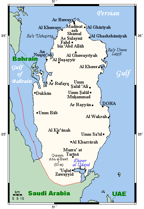
Qatar is a peninsula in the east of Arabia, bordering the Persian Gulf and Saudi Arabia in a strategic location near major petroleum and natural gas deposits. The State of Qatar occupies 11,571 km2 (4,468 sq mi) on a peninsula that extends about 160 km (99 mi) north into the Persian Gulf from the Arabian Peninsula.[1]
Varying in width between 55 and 90 km (34 and 56 mi), the land is mainly flat (the highest point is 103 m (338 ft)) and rocky.[1] Notable features include coastal salt pans, elevated limestone formations (the Dukhan anticline) along the west coast under which lies the Dukhan oil field, and massive sand dunes surrounding Khor Al Adaid, an inlet of the Persian Gulf in the southeast known to local English speakers as the Inland Sea.[1]
Area and boundaries
[edit]Qatar has one land border. The country borders Saudi Arabia to the south. The boundary with Saudi Arabia was settled in 1965 but never demarcated.[1] This terrestrial sector extends from the head of the Gulf of Salwah at Abu Samra to Khor Al Adaid,[2] spanning a linear distance of approximately 87 kilometres (54 mi).[3]
Qatar presents as a peninsula encompassed by the tepid waters of the Persian Gulf on its eastern and northern flanks. The western margin is delineated by the Gulf of Salwah, a concave formation which effectively severs Qatar's terrestrial connection with the Al-Ahsa coast and Bahrain.[2]
Qatar's northwest coast is fewer than 30 km (19 mi) from the main islands of Bahrain,[1] while the small Hawar Islands of Bahrain are only 1.9 kilometres (1.2 mi) off the coast.[4] The largest islet of the Hawar Islands is located 5 kilometres (3.1 mi) off Qatari mainland.[5] The peninsula's northernmost point is Ras Rakan.[6]
Maritime claims
[edit]Qatar's maritime boundaries include a contiguous zone of 24 nmi (44.4 km; 27.6 mi), an exclusive economic zone of 31,590 km2 (12,197 sq mi) as determined by bilateral agreements, and 12 nmi (22.2 km; 13.8 mi) of territorial sea. Maritime boundaries were ratified in April 1992 with Decree No. 40.[7] The exclusive economic zone was declared in 1974.[8]
Situated on the western shore of the Persian Gulf, the Qatari promontory extends longitudinally into the waters, affording it a strategic position for the interception of rain-bearing winds and the regulation of maritime currents in the south-western basin of the Persian Gulf. The extended coastline facilitates the exploitation of pearl banks and piscatorial resources while also providing access to subaqueous petroleum deposits.[2] Aside from hosting large numbers of pearl beds yielding high quality pearls,[9] Qatari waters also host 48% of the coral reefs in the Persian Gulf.[10]
The Qatari coast is further distinguished by its manifold indentations, comprising both convex protrusions of land into the sea, such as Ras Laffan, and concave incursions of water into the terrestrial mass. Moreover, the littoral serves as a natural harbour and transit point for numerous vessels plying the waters of the Persian Gulf.[2]
Islands
[edit]Of the islands belonging to Qatar, Halul is the most important.[1] Lying about 90 km (56 mi) east of Doha, it serves as a storage area and loading terminal for oil from the surrounding offshore fields.[1] Hawar and the adjacent islands immediately off the west coast are the subject of a territorial dispute between Qatar and Bahrain.[1]
Climate
[edit]
The long summer (June through September) is characterized by intense heat and alternating dryness and humidity, with temperatures exceeding 40 °C (104 °F).[1] Temperatures are moderate from November to March,[1] ranging from as high as 39 °C (102 °F) in April to as low as 7 °C (45 °F) in January.[11] Rainfall averages 100 mm (3.9 in) per year, confined to the winter months, and falling in brief storms which are occasionally heavy enough to flood the small ravines and the usually dry wadis.[1]
Sudden, violent dust storms occasionally descend on the peninsula, blotting out the sun, causing wind damage, and temporarily disrupting transport and other services.[1]
The scarcity of rainfall and the limited underground water, most of which has such a high mineral content that it is unsuitable for drinking or irrigation, severely restricted the population and the extent of agricultural and industrial development the country could support until desalination projects began.[1] Although water continues to be provided from underground sources, most is obtained by desalination of seawater.[1]
| Climate data for Doha (1962–2013, extremes 1962–2013) | |||||||||||||
|---|---|---|---|---|---|---|---|---|---|---|---|---|---|
| Month | Jan | Feb | Mar | Apr | May | Jun | Jul | Aug | Sep | Oct | Nov | Dec | Year |
| Record high °C (°F) | 32.4 (90.3) |
36.5 (97.7) |
41.5 (106.7) |
46.0 (114.8) |
47.7 (117.9) |
49.1 (120.4) |
50.4 (122.7) |
48.6 (119.5) |
46.2 (115.2) |
43.4 (110.1) |
38.0 (100.4) |
32.7 (90.9) |
50.4 (122.7) |
| Mean daily maximum °C (°F) | 22.0 (71.6) |
23.4 (74.1) |
27.3 (81.1) |
32.5 (90.5) |
38.8 (101.8) |
41.6 (106.9) |
41.9 (107.4) |
40.9 (105.6) |
38.9 (102.0) |
35.4 (95.7) |
29.6 (85.3) |
24.4 (75.9) |
33.1 (91.5) |
| Daily mean °C (°F) | 17.8 (64.0) |
18.9 (66.0) |
22.3 (72.1) |
27.1 (80.8) |
32.5 (90.5) |
35.1 (95.2) |
36.1 (97.0) |
35.5 (95.9) |
33.3 (91.9) |
30.0 (86.0) |
25.0 (77.0) |
20.0 (68.0) |
27.8 (82.0) |
| Mean daily minimum °C (°F) | 13.5 (56.3) |
14.4 (57.9) |
17.3 (63.1) |
21.4 (70.5) |
26.1 (79.0) |
28.5 (83.3) |
30.2 (86.4) |
30.0 (86.0) |
27.7 (81.9) |
24.6 (76.3) |
20.4 (68.7) |
15.6 (60.1) |
22.5 (72.5) |
| Record low °C (°F) | 3.8 (38.8) |
1.5 (34.7) |
8.2 (46.8) |
10.5 (50.9) |
15.2 (59.4) |
21.0 (69.8) |
23.5 (74.3) |
22.4 (72.3) |
20.3 (68.5) |
16.6 (61.9) |
11.8 (53.2) |
6.4 (43.5) |
1.5 (34.7) |
| Average precipitation mm (inches) | 13.2 (0.52) |
17.1 (0.67) |
16.1 (0.63) |
8.7 (0.34) |
3.6 (0.14) |
0.0 (0.0) |
0.0 (0.0) |
0.0 (0.0) |
0.0 (0.0) |
1.1 (0.04) |
3.3 (0.13) |
12.1 (0.48) |
75.2 (2.95) |
| Average precipitation days (≥ 1.0 mm) | 1.7 | 2.1 | 1.8 | 1.4 | 0.2 | 0.0 | 0.0 | 0.0 | 0.0 | 0.1 | 0.2 | 1.3 | 8.8 |
| Average relative humidity (%) | 74 | 70 | 63 | 53 | 44 | 41 | 50 | 58 | 62 | 63 | 66 | 74 | 60 |
| Mean monthly sunshine hours | 244.9 | 224.0 | 241.8 | 273.0 | 325.5 | 342.0 | 325.5 | 328.6 | 306.0 | 303.8 | 276.0 | 241.8 | 3,432.9 |
| Mean daily sunshine hours | 7.9 | 8.0 | 7.8 | 9.1 | 10.5 | 11.4 | 10.5 | 10.6 | 10.2 | 9.8 | 9.2 | 7.8 | 9.4 |
| Source 1: NOAA[12] | |||||||||||||
| Source 2: Qatar Meteorological Department (Climate Normals 1962–2013)[13][14] | |||||||||||||
| Month | Jan | Feb | Mar | Apr | May | Jun | Jul | Aug | Sep | Oct | Nov | Dec | Year |
|---|---|---|---|---|---|---|---|---|---|---|---|---|---|
| Average sea temperature °C (°F) | 21.0 (69.8) |
19.4 (66.9) |
20.9 (69.6) |
23.3 (73.9) |
27.8 (82) |
30.5 (86.9) |
32.4 (90.3) |
33.6 (92.5) |
32.8 (91) |
30.8 (87.4) |
27.5 (81.5) |
23.5 (74.3) |
26.9 (80.5) |
| Source:[15] | |||||||||||||
Topography and natural regions
[edit]
The peninsula of Qatar is low-lying. Its shape is the surface expression of the anticlinal Qatar Arch,[16] formed during the Precambrian Amar Collision about 640 to 620 million years ago.[17] It is enveloped by loose sand and pebbles broken off the outcropping limestone. Smooth plains covered by fine-grained dust are found in the east, while the south and south-west portions of the peninsula mainly comprise sand dunes and salt flats (locally known as sabkhas), particularly near Mesaieed and Khor Al Adaid.[18] Sakbahs can also be found in western Qatar, near Dukhan and Sawda Natheel.[19] Hill ranges (jebels) can be found in western Qatar near Dukhan and at Jebel Fuwayrit on the northeast coast.[20] For purposes of categorization, the country is divided into five principal regions: coastal plain, interior plain, central belt, Dukhan region, and southern desert.[2]
Coastal plain
[edit]The littoral of Qatar, extending some 650 kilometres (400 mi) from Abu Samra to Khor Al Adaid via Ar Ru'ays, is emergent and characterized by recent geological formations. The western coast from Abu Samra to Ras Dukhan is relatively straight, while northward to Ar Ru'ays is indented with circular and oblong water incursions. The eastern coast is broader, with elevations increasing eastward from Dohah Al Husain.[2] Many flat, low-lying offshore islands are located near the coast and are accompanied by coral reefs. As a result of salt water coming into contact with the low-lying land, many salt flats (known locally as sabkhas) have formed near the coast.[18]
Interior plain
[edit],_desert.jpg)
Commencing at the inland margins of the coastal strip, this region is demarcated in the north by the Al Mafjar-Abu Dhalouf line. It broadens considerably southward, with its northern sector spanning 18.5 kilometres (11.5 mi) between Al-ʽAdhbah and Ar Rakiyat, while its southern base between Umm Al Qahab and Al Suwaihliya measures 46.5 kilometres (28.9 mi). The surface is studded with eleven closed basins. The northern sector is relatively flat, while the central sector, between Fuwayrit and Rawdat Al Faras, exhibits more complex topography with elevations ranging from 11 metres (36 ft) to 21 metres (69 ft).[2]
Central belt
[edit]This zone aligns with Qatar's primary north-south oriented dome. It is distinguished by its topographical diversity, with elevations ranging from 31 metres (102 ft) to 49 metres (161 ft) above sea level. The surface is uneven, with circular or rectangular hills along the western borders reaching heights of 41 metres (135 ft) to 49 metres (161 ft). Fourteen closed basins are scattered throughout, smaller in the east within the Rus Formation and larger in the west within the Dammam Formation. The highest points are found in the hills southeast of Al Jemailiya and to the west of the Al Jemailiya-Ash-Shahaniyah road.[2]
Dukhan region
[edit]
Occupying the greater part of Qatar's western flank, this area extends 87 kilometres (54 mi) from Ras Abrouq in the north to An Nakhsh in the south. It is characterized by complex structural units, with elevations reaching 92 metres (302 ft) at Khashm An-Nakhsh and depressions as low as −5 metres (−16 ft) below sea level in the Dukhan Sabkha.[2] This sabkha, the largest inland salt flat in the Persian Gulf, runs for approximately 20 kilometres (12 mi), occupies an area of 73 km2 (28 sq mi),[21] and accommodates the lowest point of Qatar at −6 metres (−20 ft) below sea level.[19] Jebel Nakhsh, a notable mountain ridge south of Dukhan, contains substantial deposits of gypsum.[22]
Southern desert
[edit]
This region occupies 34.7% of Qatar's total area, south of Doha's latitude. It bears topographical similitude to the desert areas of Abu Dhabi, Saudi Arabia, and Bahrain, with undulating sand dunes interspersed with rocky hamada surfaces.[2] It is divided into four sub-regions:
- Al Urayq: A triangular area in the extreme west, with its apex at Abu Samra. Its northern side aligns with the southern extremity of the Doha-Abu Samra road, and its southern side follows the border line from Abu Samra towards the southeast.[2]
- Miocene-Tiwar: Characterized by isolated hills amidst a rocky plain. The hills reach a maximum of 103 metres (338 ft) and include Qatar's highest point, Qurayn Abu al Bawl. This sub-region is concentrated in the southwestern part of the Qatar Peninsula, including areas like Mukaynis, Al Kharrara, and Wadi Jallal.[2]
- Rocky surfaces: Consisting of expanses of exposed bedrock, often weathered into flat, stony plains known as desert pavements. The surface may be covered by a mosaic of closely packed pebbles and rock fragments, or in some places by a thin layer of indurated mineral deposits forming a hard crust. This sub-region is divided into two units: one shaped like a trapezoid bounded by the water pipeline passing through Abu Nakhla to Mesaieed, and another extending from Umm Jawlaq southeastward through Al Khubayb, Al Fulayhah, and Umm Al Hayran to Khor Al Adaid.[2]
- Sand dunes: Occupying 1.6% of Qatar's area, with dunes reaching heights of 38 metres (125 ft) to 67 metres (220 ft). Interspersed among the dunes are numerous closed basins with floors varying in elevation from 19 metres (62 ft) to 34 metres (112 ft) metres above sea level, resulting in an undulating topography. The northern boundary of this sub-region aligns with the latitude of Umm Owaina.[2]
Landforms
[edit]
Sabkhas
[edit]The peninsula is notable for its sabkhas, or salt flats, of which the two distinct varieties are coastal and inland. The coastal sabkhas, more prevalent on the eastern seaboard, encompass an area of approximately 75 km2 (29 sq mi). These coastal formations rarely exceed an elevation of 1 metre (3 ft 3 in) to 2 metres (6 ft 7 in) metres above sea level, with some portions lying below the waterline. Consequently, during exceptionally high tides, often exacerbated by strong easterly winds, seawater may inundate these low-lying areas.[23]
Inland sabkhas, while less common, are of significant geological interest. A prominent example, Dukhan Sabkha, lies 3 kilometres east of Jebel Dukhan and south of the Bay of Zekreet. This depression, covering 73 km2 (28 sq mi), is largely situated below sea level and contains the lowest point in Qatar at −6 metres (−20 ft) below the sea's surface.[24] It stretches 24 kilometres from north to south and 6 kilometres (3.7 mi) from east to west.[23] A second notable inland sabkha complex straddles the borders of Qatar, Saudi Arabia, and the United Arab Emirates. This formation comprises three discrete areas: Sawda Natheel to the south, Jawa Salama to the west, and Al Khufus to the east. These sabkhas, mostly subsea in elevation, collectively span an area of 25 km2 (9.7 sq mi).[23]
Depressions
[edit]_near_Jebel_Jassasiya_in_northern_Qatar.jpg)
The surface of the Qatar Peninsula is punctuated by numerous small depressions, referred to as rawda or the plural riyadh. These formations present as enclosed basins, save for those in the south-central region which may be open on one or more sides. The morphology of these depressions is diverse, ranging from circular to elongated forms, with some exhibiting irregular platforms. The scale of these depressions also varies widely. The most extensive, such as the Almajdah Depression, stretch for several kilometres, while the smallest span mere tens of metres. Their formation is primarily attributed to the dissolution of surface limestone by rainwater runoff, a process that has been active across much of the peninsula.[25]
Valleys
[edit]Dry valleys, known as wadis, are featured most prominently in Qatar's northern region and the vicinity of Jebel Dukhan. They are characterised by their internal drainage systems, which terminate in shallow depressions rarely exceeding 2 to 3 metres in depth. While they may extend for several kilometres in length, they maintain a remarkably narrow profile, with a width invariably less than 100 metres.[25]
Hills
[edit](8),_desert.jpg)
The peninsula features several low hills scattered throughout its western and southern regions. Notable among these is Jebel Dukhan, a series of convex hillocks extending 80 kilometres (50 mi) north-south along the west coast. The peninsula's terrain also features distinctive flat-topped hills, formed by horizontal strata capped with relatively hard rock. These formations exhibit steep, often concave or stepped slopes, shaped by varying degrees of rock resistance.[26]
Topographical features range from small, conical hills—where the resistant rock cap has eroded—to more extensive mesa-like formations. Elevation varies considerably; in the Zekreet Peninsula and near Al Khor, the hills are 10 metres (33 ft) to 15 metres (49 ft) above sea level. The southern hills are much taller, with Qatar's highest point, Qurayn Abu al Bawl (also known as Tuwayyir Al Hamir) being over 100 metres (330 ft) above sea level.[26]
Wildlife
[edit]Flora
[edit]
Although most of the country consists of sand deserts, a small part of the country houses different vegetation zones, where trees, reeds and shrubs like tamarind, phragmites, and mace can grow. These regions are mostly to the east, near the coast. The inherent limiting factor for vegetation growth is water availability. Certain geographical features partially alleviate this water scarcity, such as rawdas, which are large depressions found on the soil surface and which help recharge the aquifers.[27] As these sites constitute the most easily obtainable sources of shallow groundwater, they are also among the areas most abundant in wild vegetation.[28]
In the south, where groundwater is exceedingly scarce, vegetation can found growing in wadis (dry river valleys) fed by run-off from nearby hills and in rawdas.[29] Sabkhas are another habitat known to contain various plant species. Vegetation in sabkhas is closely tied to soil salinity and moisture availability. Inland sabkhas are typically sparsely vegetated due to extreme salinity and aridity. Species that persist under these conditions include Zygophyllum qatarense, Anabasis setifera, which occurs along sabkha margins, and the halophytic grass Aeluropus lagopoides. By contrast, coastal sabkhas situated beyond mangrove zones are more frequently vegetated, often supporting dense stands of salt-tolerant flora. Typical genera include Arthrocnemum, Halocnemum, Halopeplis, and Limonium. Halopeplis and Limonium are commonly found on slightly raised, drier saline land, whereas Arthrocnemum and Halocnemum are more abundant in low-lying, moisture-retaining areas.[30]
Fauna
[edit]
There are 21 species of mammals that have been recorded in Qatar.[31] Larger terrestrial mammals such as the Arabian oryx and Arabian gazelle are protected animals and are held in nature reserves.[32] The Arabian gazelle is the only native gazelle species to Qatar and is locally referred to as 'rheem'.[33]
Qatar's territorial waters in the Persian Gulf are rich in marine life. Sea turtles nest en masse on the coastline from Fuwayrit to Ras Laffan. The Ministry of Environment (MME) carries out routine patrols of nesting areas to ensure their conservation.[34] Dugongs are known to congregate off the country's coasts. In the course of a study being carried out in 1986 and 1999 on the Persian Gulf, the largest-ever group sightings were made of more than 600 individuals to the west of Qatar.[35]
Geology and mineral deposits
[edit]

| Era[36][37] | Period | Formation | Member | Mineral deposits and resources |
|---|---|---|---|---|
| Paleozoic | Cambrian | Hormuz Formation | Dolomite, sandstone | Hematite, carbonates, asbestos |
| Permian Carboniferous |
Khuff Formation | Petroleum | ||
| Mesozoic | Jurassic | Uwainat Limestone Formation, Arab Formation | Dolomite, limestone, evaporite, shale | Petroleum |
| Cretaceous | Shuaiba Formation | Marlstone, limestone, shale | Petroleum | |
| Cenozoic | Paleocene | Umm Er Radhuma Formation | ||
| Lower Eocene | Rus Formation | Chalk | Celestine, gypsum | |
| Lower Dammam Formation | Dukhan limestone, Midra shale, Rudjm Aid limestone | Palygorskite, pyrite | ||
| Middle Eocene | Upper Dammam Formation | Umm Bab chalk, Simaisma dolomites | Dolomite, limestone | |
| Miocene | Upper and Lower Dam Formation | Clay, limestone, gypsum | Clay, limestone, celestine | |
| Pliocene | Hofuf Formation | Sandy clay, sandstone | Sand, gravel | |
| Pleistocene | Miliolite limestone | Limestone | ||
Most of Qatar's surface lies on Cenozoic strata. These strata have an abundance of mineral resources, most of which have not yet been exploited, such as limestone and clay.[38] The Upper Dammam Formation in the Middle Eocene period is the most predominant surface layer. It is constituted by limestone and Dolomite.[39] The northern zone of Qatar, which comprises the most significant source of fresh groundwater in the peninsula, primarily draws its water from the Umm Err Radhuma Formation and Rus Formation dating to the Paleocene and Lower Eocene periods, respectively.[40] The Mesozoic strata are the most important layers as they contain petroleum. The first substantial deposit of crude oil was discovered in 1940 in the Jurassic period Arab Formation.[41]
Resources and land use
[edit].svg)
Based on 2011 estimates, 5.6% of the land is agricultural. Arable land comprises 1.1%, permanent crops 0.2% and permanent pasture 4.6%.[Doesn't add to 5.6%.] 94.4% of the land was used for other uses.[42] In 2003, 129.4 km2 (50.0 sq mi) of land was irrigated.[42]
Severe conditions, such as extremely high temperatures and lack of water and fertile soil, hinder increased agricultural production.[1] Orthents, the predominant soil type in the peninsula, accounting for approximately 1,020,000 ha, are unfavorable for crop cultivation because of their extreme shallowness.[43] The limited groundwater that permits agriculture in some areas is being depleted so rapidly that saltwater is encroaching and making the soil inhospitable to all but the most salt-resistant crops.[1]
Political and human geography
[edit]

The capital, Doha, is located on the central east coast on a sweeping (if shallow) harbor.[1] Other ports include Umm Said, Al Khawr, and Al Wakrah. Only Doha and Umm Said are capable of handling commercial shipping, although a large port and a terminal for loading natural gas are planned at Ras Laffan Industrial City, north of Al Khawr.[1] Coral reefs and shallow coastal waters make navigation difficult in areas where channels have not been dredged.[1]
Doha is the capital of the country and the major administrative, commercial, and population center.[1] In 1993 it was linked to other towns and development sites by a system of about 1,000 km (620 mi) of paved roads.[1] Doha's international airport has an approximately 4,500 m (14,800 ft) main runway, capable of receiving all kinds of aircraft.[1]
Historically, settlement distribution in Qatar has mainly been dictated by the presence of obtainable fresh groundwater.[27] Rawdas, which are depressions with shallow groundwater, have typically been the most popular sites of settlement throughout the peninsula.[28] In Qatar's south, where groundwater is exceedingly difficult to obtain, settlement formation was mostly limited to wadis (dry river valleys) fed by run-off from nearby hills and rawdas.[27]
Environmental agreements
[edit]Qatar is currently party to the following international environmental agreements:[42]
References
[edit]- ^ a b c d e f g h i j k l m n o p q r s t u v Toth, Anthony (1994). "Qatar: Geography". In Metz, Helen Chapin (ed.). Persian Gulf states: country studies (3rd ed.). Washington, D.C.: Federal Research Division, Library of Congress. pp. 162–163. ISBN 0-8444-0793-3. OCLC 29548413.
 This article incorporates text from this source, which is in the public domain.
- ^ a b c d e f g h i j k l m n "طبوغرافية شبه جزيرة قطر" (in Arabic). Qatar Historical Encyclopedia. 28 April 2024. Archived from the original on 25 July 2024. Retrieved 20 July 2024.
- ^ CIA World Factbook – Saudi Arabia, retrieved 20 July 2024
- ^ Al Sharif, Farah (1 August 2021). "Qatar-Bahrain territorial dispute erupts online as ownership claims resurface on Twitter". Doha News. Retrieved 20 July 2024.
- ^ Wiegand, Krista E. (2012). "Bahrain, Qatar, and the Hawar Islands: Resolution of a Gulf Territorial Dispute". Middle East Journal. 66 (1). Middle East Institute.
- ^ Bird, Eric (2010). Encyclopedia of the World's Coastal Landforms. Springer. p. 1038. ISBN 978-1-4020-8638-0.
- ^ Bugajski, Dariusz R. (2016). "The Persian Gulf in the Light of the Law of the Sea" (PDF). Prawo Morskie (XXXII): 32. ISSN 0860-7338.
- ^ Bugajski, Dariusz R. (2016). "The Persian Gulf in the Light of the Law of the Sea" (PDF). Prawo Morskie (XXXII): 26. ISSN 0860-7338.
- ^ "The pearling industry in Qatar". Museum With No Frontiers. Retrieved 20 July 2024.
- ^ "Qatar home to 48% of coral reefs in Arabian Gulf". The Peninsula Qatar. 17 October 2022. Retrieved 21 May 2024.
- ^ Casey & Vine (1991), p. 69
- ^ "Doha International Airport Climate Normals 1962-1992". National Oceanic and Atmospheric Administration. Archived from the original on 2017-10-11. Retrieved September 29, 2016.
- ^ "Climate Information For Doha". Qatar Meteorological Department. Archived from the original on November 27, 2016. Retrieved November 27, 2016.
- ^ "41170: Doha International Airport (Qatar)". ogimet.com. OGIMET. 19 March 2021. Retrieved 19 March 2021.
- ^ "Doha Sea Temperature". seatemperature.org. Retrieved 28 May 2022.
- ^ Jeremy Jameson; Christian Strohmenger (2012). "What's up with Qatar? How eustasy and neotectonics influenced the late Pleistocene and Holocene sea-level history of Qatar". Qatar Foundation Annual Research Forum Proceedings (2012). ExxonMobil Research Qatar: EEP4. doi:10.5339/qfarf.2012.EEP4. Retrieved 17 July 2015.
- ^ Hosani, Khalid Al; Roure, Francois; ELLISON, Richard; LOKIER, Stephen (2012-09-14). Lithosphere Dynamics and Sedimentary Basins: The Arabian Plate and Analogues. Springer Science & Business Media. ISBN 978-3-642-29278-1.
- ^ a b Abdul Nayeem, Muhammad (1998). Qatar Prehistory and Protohistory from the Most Ancient Times (Ca. 1,000,000 to End of B.C. Era). Hyderabad Publishers. p. 2. ISBN 978-81-85492-04-9.
- ^ a b Sadiq, Abdulali M. (2003). "Geologic Evolution of the Dukhan salt flats in Western Qatar Peninsula, Arabian Gulf" (PDF). Qatar University Science Journal (23): 41–58. Retrieved 23 February 2019.
- ^ "About Qatar". Ministry of Municipality and Environment. Archived from the original on 14 February 2019. Retrieved 23 February 2019.
- ^ Howell G. M. Edwards; Fadhil Sadooni; Petr Vítek; Jan Jehlička (13 July 2010). "Raman spectroscopy of the Dukhan sabkha: identification of geological and biogeological molecules in an extreme environment". Philosophical Transactions of the Royal Society A: Mathematical, Physical and Engineering Sciences. 368 (1922). Royal Society Publishing: 3099–3107. Bibcode:2010RSPTA.368.3099E. doi:10.1098/rsta.2010.0101. hdl:10576/47356. PMID 20529947. S2CID 7262453. Retrieved 23 February 2019.
- ^ Jacques Leblanc (December 2015). "A Historical Account of the Stratigraphy of Qatar, Middle-East (1816 to 2015)". Academia. p. 73. Retrieved 23 February 2019.
- ^ a b c Alsheeb, Ali I. M. (1988). Coastal geomorphology of the Qatar Peninsula (PDF) (Thesis). Swansea University. pp. 29–30.
- ^ Howell G. M. Edwards; Fadhil Sadooni; Petr Vítek; Jan Jehlička (13 July 2010). "Raman spectroscopy of the Dukhan sabkha: identification of geological and biogeological molecules in an extreme environment". Philosophical Transactions of the Royal Society A: Mathematical, Physical and Engineering Sciences. 368 (1922). Royal Society Publishing: 3099–3107. Bibcode:2010RSPTA.368.3099E. doi:10.1098/rsta.2010.0101. hdl:10576/47356. PMID 20529947. S2CID 7262453. Retrieved 23 February 2019.
- ^ a b Alsheeb, Ali I. M. (1988). Coastal geomorphology of the Qatar Peninsula (PDF) (Thesis). Swansea University. p. 30.
- ^ a b Alsheeb, Ali I. M. (1988). Coastal geomorphology of the Qatar Peninsula (PDF) (Thesis). Swansea University. p. 32.
- ^ a b c Macumber, Phillip G. (2015). "Water Heritage in Qatar". Cultural Heritages of Water: Thematic Study on The Cultural Heritages of Water in the Middle East and Maghreb. UNESCO World Heritage Convention. academia.edu. UNESCO. p. 223. Retrieved 21 February 2019.
- ^ a b Macumber, Phillip G. (2015). "Water Heritage in Qatar". Cultural Heritages of Water: Thematic Study on The Cultural Heritages of Water in the Middle East and Maghreb. UNESCO World Heritage Convention. academia.edu. UNESCO. p. 226. Retrieved 21 February 2019.
- ^ Macumber, Phillip G. (2015). "Water Heritage in Qatar". Cultural Heritages of Water: Thematic Study on The Cultural Heritages of Water in the Middle East and Maghreb. UNESCO World Heritage Convention. academia.edu. UNESCO. p. 227. Retrieved 21 February 2019.
- ^ Abdel Bari, Ekhlas M.M.; Yasseen, Bassam Taha; Al-Thani, Roda Fahad (2007). Halophytes in the State of Qatar (PDF). Environmental Studies Center of Qatar University. pp. 45–50.
- ^ "Mammals database". Qatar e-nature. Retrieved 21 February 2019.
- ^ Casey, Paula; Vine, Peter (1992). The heritage of Qatar. Immel Publishing. pp. 103. ISBN 978-0-907151-50-0.
- ^ "Arabian Goitered Gazelle (Reem)". Al Waabra Wildlife Preservation. Retrieved 21 February 2019.
- ^ Rees, Alan F.; Zogaris, Stamatis; Papathanasopoulou, Nancy; Vidalis, Aris; Alhafez, Ali (April 2013). "Qatar Turtle Management Project: Inception report". researchgate.net. Ministry of Environment (Qatar). Retrieved 21 February 2019.
- ^ Paul Sillitoe (1 August 2014). Sustainable Development: An Appraisal from the Gulf Region. Berghahn Books. p. 280. ISBN 978-1-78238-372-7.
- ^ Casey & Vine (1991), p. 73
- ^ Al-Kubaisi, Mohammed Ali M. (1984). Industrial development in Qatar: a geographical assessment (PDF). Durham E-Theses, Durham University. p. 12.
- ^ Al-Kubaisi, Mohammed Ali M. (1984). Industrial development in Qatar: a geographical assessment (PDF). Durham E-Theses, Durham University. pp. 10–11.
- ^ Al-Saad, Hamad (2015). "Lithostratigraphy of the Middle Eocene Dammam Formation in Qatar, Arabian Gulf: effects of sea-level fluctuations along a tidal environment". Journal of Asian Earth Sciences. 25 (5): Abstract. doi:10.1016/j.jseaes.2004.07.009. Retrieved 27 July 2015.
- ^ "Umm er Radhuma-Dammam Aquifer System (Centre)". Inventory of Shared Water Resources in Western Asia. Retrieved 27 July 2015.
- ^ Al-Kubaisi, Mohammed Ali M. (1984). Industrial development in Qatar: a geographical assessment (PDF). Durham E-Theses, Durham University. p. 11.
- ^ a b c "Geography". CIA World Factbook. Retrieved 17 July 2015. This article incorporates public domain material from The World Factbook. CIA.
- ^ Al-Kubaisi, Mohammed Ali M. (1984). Industrial development in Qatar: a geographical assessment (PDF). Durham E-Theses, Durham University. p. 15.
Bibliography
[edit]- Casey, Paula; Vine, Peter (1991). The heritage of Qatar (print ed.). Immel Publishing. ISBN 978-0-907151-50-0.
External links
[edit]- "East of Qatar". Terrestrial Ecoregions. World Wildlife Fund.
Climate change by country | |
|---|---|
| Africa | |
| Americas | |
| Asia |
|
| Europe | |
| Oceania | |
| Polar regions | |
| Other regions | |
Geography of Qatar
View on GrokipediaPhysical Location and Boundaries
Coordinates, Area, and Borders
Qatar occupies a peninsula on the northeastern coast of the Arabian Peninsula, extending northward into the Persian Gulf from the main landmass. The country's central geographic coordinates are approximately 25°30′N 51°45′E.[1] The total land area of Qatar measures 11,586 square kilometers, with no appreciable inland water bodies, rendering the land and total areas equivalent.[1] Official estimates from Qatar's Planning and Statistics Authority place the area at 11,637 square kilometers based on 2020 census zoning.[2] Qatar maintains a single land border with Saudi Arabia along its southern boundary, totaling 87 kilometers in length.[1] This border, primarily consisting of desert terrain, connects via the Abu Samra crossing point approximately 120 kilometers southwest of Doha.[3] Beyond this terrestrial frontier, Qatar is otherwise enveloped by Persian Gulf waters, influencing its strategic positioning amid regional maritime boundaries.Maritime Territory and Exclusive Economic Zone
Qatar claims a territorial sea extending 12 nautical miles (22 kilometers) from its baselines, as governed by Decree-Law No. 40 of 1992, which measures the breadth from bay closing lines and includes deposited geographical coordinates submitted to the United Nations in 2017.[4] A contiguous zone of 24 nautical miles is also asserted, permitting control over security, immigration, and customs matters beyond the territorial sea.[1] These zones align with standard provisions under the United Nations Convention on the Law of the Sea (UNCLOS), to which Qatar acceded on 9 December 2002, though domestic law predates formal ratification. The exclusive economic zone (EEZ) extends rights to seabed and water column resources up to 200 nautical miles, but in the enclosed Persian Gulf, its boundaries are constrained by proximity to neighboring states and resolved primarily through bilateral agreements rather than full median-line equidistance.[1] Qatar exercises sovereign rights in the EEZ for exploration, exploitation, conservation, and management of natural resources, including fisheries and hydrocarbons, with delimitations emphasizing equitable principles informed by coastal geography and existing accords. In May 2019, the Qatari government delineated specific EEZ blocks via ministerial decision, measured seaward from baselines along the mainland and affiliated islands, enabling structured licensing for oil and gas activities while asserting full control over resources therein.[5] Maritime boundaries with Iran are set by a 20 September 1969 continental shelf agreement, effective 10 May 1970, which divides the shared North Field (South Pars) gas reservoir along a median line, supporting joint development of one of the world's largest non-associated gas fields spanning approximately 6,000 square kilometers across the boundary.[6] With Saudi Arabia, a 4 December 1965 agreement establishes the land and maritime frontier from the inland Duhat as-Salwa point to Khor al-Udayd, clarified by joint minutes on 5 July 2008 addressing demarcation details.[4] The boundary with the United Arab Emirates follows a 20 March 1969 accord, effective immediately, focusing on shelf division in the southern Gulf approaches.[4] Delimitation with Bahrain was adjudicated by the International Court of Justice in 16 March 2001, awarding Qatar sovereignty over low-tide elevations like Fasht ad Dibal and applying single maritime boundary principles for overlapping zones, resolving long-standing claims over Hawar Islands and adjacent waters.[7] These agreements reflect pragmatic delimitations shaped by the Gulf's semi-enclosed nature, where overlapping claims necessitate negotiation over median lines to avoid resource conflicts, particularly for hydrocarbons that constitute over 90% of Qatar's export revenues. No major unresolved maritime disputes persist as of 2025, though routine coordination occurs for navigation safety and environmental protection in shared zones.[1]Islands, Reefs, and Offshore Features
Qatar's offshore islands consist of approximately ten small, low-lying formations primarily along its eastern and northern coasts in the Persian Gulf, characterized by flat topography of limestone platforms and sandy deposits. These islands, many uninhabited, total less than 10 square kilometers in combined area and often feature sparse vegetation adapted to arid conditions.[8][9] Halul Island, the most economically significant, lies 90 kilometers northeast of Doha at approximately 25°40′N 52°27′E, spanning 1.5 square kilometers. It serves as Qatar's main offshore oil storage and loading terminal, with facilities supporting crude export since the 1970s, and hosts limited wildlife including introduced mountain goats.[10][11][12] Al Khor Island, also known as Purple Island or Jazirat bin Ghanim, is positioned about 40 kilometers north of Doha near Al Khor city, featuring low hillocks, mangrove fringes, and archaeological sites from the Bronze Age including pottery and structures.[13][14] Al Safliya Island, a minor uninhabited islet roughly 5 kilometers offshore north of Ras Abu Aboud near Doha, measures under 1 square kilometer and provides shallow beaches suitable for marine recreation, reachable by boat in 30 to 40 minutes.[15] Other notable islands include Al Aaliya Island to the north and smaller features like Al Maha, which similarly exhibit minimal relief and support coastal ecosystems.[16] Coral reefs in Qatari waters are concentrated as fringing structures along the northern and eastern coasts, with patch reefs and communities extending onto the eastern shelf and around offshore islands and seamounts, typically at depths of 3 to 25 meters. These thermally extreme environments, reaching summer temperatures over 35°C, sustain approximately 35 hard and soft coral species and more than 200 fish species, comprising a significant portion of the Arabian Gulf's reef biodiversity despite covering limited area.[17][18][19][20] Offshore features beyond islands include submarine banks and isolated reefs, which contribute to habitat complexity within Qatar's exclusive economic zone, though extensive mapping remains ongoing due to shallow, sediment-influenced seabeds.[18]Topography and Landforms
Coastal Zones and Plains
Qatar's coastal zones form a low-lying fringe along its 563-kilometer mainland shoreline in the Persian Gulf, dominated by emergent plains of Quaternary carbonates and evaporites.[21] [22] These zones transition inland into broader gravel and sand plains, with elevations rarely exceeding 10 meters above sea level.[23] The terrain reflects tectonic stability and eolian-marine sedimentation, yielding flat, rocky expanses punctuated by salt pans.[24] Sandy beaches, composed of fine quartz grains sourced from adjacent dune fields, characterize much of the eastern coast, including areas near Doha and Al Khor, where wave action and tidal currents maintain widths up to 100 meters.[25] Coral reefs and patch reefs offshore protect these beaches from erosion, fostering pockets of mangroves in embayments like those at Al Thakira.[25] In contrast, the western coast features fewer beaches and more exposed limestone cliffs rising to 100 meters in the Dukhan anticline region.[21] Coastal sabkhas, hyper-saline flats formed by supratidal flooding and evaporative precipitation, extend along the southern and western margins, covering areas up to several kilometers wide and accumulating gypsum and halite crusts.[26] These features, evident in sites like Dukhan Sabkha, result from the arid climate's high evaporation rates exceeding minimal precipitation, typically less than 75 mm annually.[21] Inland from the sabkhas, coastal plains grade into rawdas—shallow depressions with calcareous soils supporting halophytic shrubs.[27] The overall coastal plain morphology stems from Holocene sea-level stabilization around 6,000 years ago, allowing progradation of carbonate platforms and accumulation of eolian sands.[25] Human modifications, including dredging for ports like Ras Laffan and Mesaieed, have altered segments, but natural low-gradient profiles persist, influencing flash flood drainage toward the sea.[28]Inland Deserts, Gravel Plains, and Salt Flats
The inland regions of Qatar feature extensive hamada plains, which are elevated, rocky desert surfaces characterized by a lag of coarse, angular gravel derived from the erosion of underlying Tertiary limestone formations. These gravel pavements result from aeolian deflation processes that remove finer particles, leaving a protective layer of pebbles and stones that inhibits further erosion and supports sparse vegetation adapted to hyper-arid conditions. Hamada landscapes dominate much of the peninsula's interior, with surface sediments consisting primarily of in situ, coarse-grained clastics transported short distances by wind.[29][21] Salt flats, known as sabkhas, occupy structural lows in the interior, particularly within synclinal depressions influenced by the anticlinal uplift of the Qatar Peninsula. The Dukhan Sabkha, located in the central-western interior south of Zikrit Peninsula, exemplifies these features, covering approximately 73 km² with a nearly horizontal surface and gradients typically less than 1:250°. Hypersalinity in such sabkhas arises from intense evaporation in the arid climate, coupled with seawater intrusion via subsurface flow and minimal dilution by precipitation, leading to the precipitation of evaporite minerals including gypsum crystals in acicular, prismatic, and lenticular habits, as well as anhydrite nodules.[30][31][32][33] Inland deserts incorporate areas of mobile sand dunes amid the gravel expanses, with barchan and seif forms prevalent in topographic basins where wind patterns accumulate loose sand from coastal or wadi sources. These dunes contribute to ongoing landscape evolution through migration and stabilization influenced by rare flash floods and vegetation anchoring, though the overall interior remains a barren, low-relief expanse with elevations generally below 50 meters above sea level. Sabkhas and hamadas together reflect the interplay of tectonic folding, hyperaridity, and episodic marine influence in shaping Qatar's endorheic interior.[21][34]Elevations, Hills, and Structural Depressions
Qatar's topography features low elevations, with the highest point reaching 103 meters above sea level at Qurayn Abu al Bawl, a limestone hill in the southern interior.[35] This elevation marks the pinnacle of the country's undulating terrain, which generally ranges from sea level to under 100 meters across its 11,586 square kilometers.[36] Other notable hills include Khashm An-Nakhsh, attaining 92 meters, and scattered rocky outcrops associated with the Dukhan anticline, a structural high in the west.[37] These hills are primarily composed of Eocene and Miocene limestone formations, exposed due to the Qatar Arch, an anticlinal structure influencing the peninsula's gentle relief.[38] Elevations decrease northward and eastward toward the coast, where plains dominate, reflecting the subdued karst landscape shaped by arid weathering and minimal fluvial erosion.[39] Structural depressions, known locally as rawda (plural riyadh), form a prominent feature, with digital elevation models identifying over 21,000 such basins covering approximately 1,799 square kilometers, or about 15% of Qatar's land area.[40] These shallow, enclosed depressions, typically 1-5 meters deep, result from Middle Pleistocene karst processes, including doline formation and cavern collapse in the soluble limestone bedrock.[41] Many contain colluvial soils supporting sparse vegetation, contrasting the surrounding gravel plains, and some extend below sea level, reaching lows of -5 meters in localized areas.[39] This karstic topography underscores Qatar's geological youth and hyper-arid environment, limiting erosional deepening while promoting surface solution features.[34]Wadis, Sabkhas, and Erosion Features
Wadis in Qatar consist of dry valleys and ephemeral streams that activate during rare flash floods, channeling sporadic rainfall and reworking surface sediments across the peninsula. These features, formed during wetter geological periods such as 5.3 to 1.8 million years ago in southern Qatar and 18,000 to 8,000 years ago in the north, are enclosed by ancient rocky hills and low-lying undulating desert, facilitating erosion through sediment transport and incision of runnels—small drainage channels. Prominent in northern Qatar and near Jebel Dukhan, wadis direct water toward depressions or sabkhas, with examples like dry washes near Zekrit exhibiting signs of recent flood activity as of spring 1997.[42][37] Sabkhas, extensive evaporitic salt flats, mark transitions between terrestrial and marine environments in Qatar, characterized by salt crusts of halite, gypsum, and anhydrite amid extreme desiccation, high salinity, temperatures, and solar radiation. Coastal sabkhas develop via tidal flooding combined with aeolian sediment input, while inland variants in northwest and southwest Qatar, including at Khor Al Adaid where dunes encroach, arise from rainwater and brackish aquifer seepage. Dukhan Sabkha, the largest inland example at 130 km² in a synclinal depression in western Qatar, features 1-2 m thick sediment layers with evaporite nodules; Umm Said Sabkha illustrates coastal dynamics with recurved spits from Holocene sea-level rise and barchan dune migration. These landforms result from deflation removing fines and intense evaporation concentrating salts.[43][37] Erosion in Qatar is chiefly aeolian, yielding ventifacts—wind-abraded, faceted stones—distributed primarily within 5 km of coastlines due to persistent sand-laden winds. Deflation hollows and rawdas, karstic depressions from carbonate dissolution and cave collapses filled with eroded soil, punctuate the landscape, enhancing fertility via runoff-deposited nutrients and supporting post-rain vegetation; Qatar records 870 to 9,736 sinkholes linked to such processes. Ephemeral fluvial action in wadis produces gullies, ravines, and pedestal rocks at plateau edges like Zekrit through flash flood undercutting, while abrasion marks on exposed limestones in sabkhas reflect combined wind and water influences.[44][45][37]Climate Patterns
Arid Desert Climate Characteristics
Qatar features a hot desert climate (BWh in the Köppen classification), marked by extreme aridity where annual precipitation averages around 80 mm, primarily occurring in sporadic winter events between November and March.[46] This scant rainfall, combined with highly erratic distribution, results in prolonged dry periods that define the region's hyper-arid conditions, with no perennial surface water bodies.[47] Potential evapotranspiration rates exceed 2,200 mm annually, far surpassing precipitation inputs and driving rapid moisture loss from soils and any available water sources.[48] High solar insolation and frequent shamal winds exacerbate aridity by enhancing evaporation and mobilizing dust, leading to frequent sandstorms that reduce visibility and further desiccate the landscape.[49] Relative humidity remains low inland, typically below 50% during daylight hours, though coastal areas experience higher nocturnal levels due to marine influence, yet overall atmospheric moisture is insufficient to support significant vegetation or hydrological recharge without artificial intervention.[50] These characteristics necessitate near-total reliance on desalination for water supply, underscoring the climate's inhospitable nature for natural water cycles.[49]Temperature Regimes, Precipitation, and Wind Patterns
Qatar's temperature regime is characterized by extreme diurnal and seasonal variations typical of a hot desert climate (Köppen BWh). Daily maximum temperatures in Doha, the capital, frequently exceed 40°C from May to September, with mean maxima reaching 41.5°C in July based on 1962–1992 data from the World Meteorological Organization.[51] Minimum temperatures during these months rarely drop below 27°C, contributing to high heat stress despite low humidity in early summer. Winters are mild, with January mean maxima around 21.7°C and minima of 12.8°C, though occasional cold fronts can lower nighttime temperatures to near 4°C, as recorded in 1964.[51] [52] The annual mean temperature in Doha averages 27.5°C, with record highs of 50.4°C observed in July 2010, reflecting intense solar insolation and subsidence from the subtropical high-pressure system.[53] [50] Precipitation is sparse and highly variable, averaging 75 mm annually in Doha, concentrated between November and March with negligible amounts (0–3.6 mm monthly) from May to October.[51] Most events occur as short, intense convective thunderstorms or associated with winter shamal fronts, totaling about 11 rain days per year, peaking at 2.1 days in February.[51] Recent data indicate slight increases, with 81.79 mm recorded in 2024, but long-term patterns show irregularity driven by Indian Ocean Dipole influences and Mediterranean cyclones, underscoring Qatar's reliance on desalination amid water scarcity.[54] Historical extremes include years with under 10 mm, emphasizing the arid regime where evaporation far exceeds inputs.[55] Wind patterns are dominated by northwesterly shamal flows, originating from high-pressure systems over the Arabian interior, with prevailing directions from the northwest year-round in Doha.[56] Winter shamals occur in 2–5 day episodes with gusts up to 20 m/s, often generating dust storms and cooler air advection, while summer shamals persist for up to 120 days at 8–13 m/s, enhancing evaporation but milder in intensity.[57] [58] Average speeds range 8–24 km/h, higher in winter (up to 10 m/s), modulated by local sea breezes from the Persian Gulf during afternoons, which introduce southeasterly components and relative humidity spikes in summer.[59] These patterns, with shamal frequency averaging 1–2 events monthly in peak seasons, influence coastal upwelling, dune migration, and air quality through frequent sand-laden winds.[60]Historical Variability and Recorded Extremes
The highest air temperature recorded in Qatar reached 50.4 °C at Doha International Airport on 14 July 2010, reflecting the intense summer heat driven by subtropical high pressure and clear skies.[61] [62] The lowest temperature on record was 1.5 °C, measured at Abu Samra on 5 February 2017 during a rare cold air intrusion from the north, marking the coldest February since systematic observations began in 1962.[63] [64] Precipitation extremes underscore the erratic nature of Qatar's rainfall, which averages around 75 mm annually but varies widely due to infrequent synoptic disturbances like low-pressure systems from the Mediterranean or Arabian Sea. The highest 24-hour rainfall total was 130.5 mm at Doha in February 1988, associated with a strong frontal system.[56] More recent events include 84 mm in under six hours at Abu Hamour in October 2018, triggering flash floods, and 69.6 mm at Al Dhakhira in January 2022.[65] [66] Annual totals have ranged from near zero in drought years to over 200 mm in wetter periods, with no clear long-term trend in total precipitation but increased intensity in isolated events.[67] Wind extremes, often linked to shamal northerlies or tropical cyclones, include gusts exceeding 100 km/h during the severe sandstorm of 1 April 2015, which blanketed the country in dust for about 12 hours, reducing visibility to under 100 meters and straining health services with respiratory cases.[68] [69] Such dust events, while common in winter and spring, show probabilistic increases in frequency under warming scenarios, tied to enhanced wind erosion from drier surfaces.[70] Historical records from 1962 onward indicate a warming trend, with annual mean temperatures rising significantly (approximately 0.5–1 °C per decade since the 1980s), amplifying heat extremes while precipitation remains variable without a monotonic increase.[71] [72] These patterns align with broader Arabian Peninsula dynamics, where urban heat islands in Doha may exacerbate local maxima.[55]| Parameter | Extreme Value | Location | Date |
|---|---|---|---|
| Highest temperature | 50.4 °C | Doha | 14 July 2010 |
| Lowest temperature | 1.5 °C | Abu Samra | 5 February 2017 |
| Highest 24-hour rainfall | 130.5 mm | Doha | February 1988 |
| Highest wind gust (storm) | >100 km/h | Widespread | 1 April 2015 |
Hydrography and Water Systems
Absence of Permanent Rivers and Surface Hydrology
Qatar possesses no permanent rivers, attributable to its hyper-arid climate where potential evapotranspiration rates, averaging 2,200 mm annually, vastly exceed precipitation inputs of approximately 74 mm per year, yielding a severe hydrological deficit that inhibits sustained surface water flow.[48] [73] This imbalance, driven by high temperatures and intense solar radiation, ensures that any precipitation rapidly dissipates through evaporation or infiltration rather than accumulating into perennial streams.[48] The flat to gently undulating topography further discourages channeling of water into persistent courses, as runoff volumes remain negligible outside episodic events.[74] Surface hydrology in Qatar is thus ephemeral, primarily manifesting through wadis—intermittent dry valleys that activate solely during rare convective rainfall events, typically between November and April.[42] These wadis, such as those in the northern and western regions, experience flash floods with high-velocity flows that erode channels but contribute little to long-term water storage, as most water infiltrates permeable dune sands or evaporates within hours to days.[75] Surface runoff constitutes only 16-20% of total precipitation, with the remainder lost to immediate evaporation or direct aquifer recharge in topographic depressions.[46] Absent any perennial inflows, Qatar's surface water dynamics reflect a closed, deficit-driven system reliant on sporadic storms rather than steady fluvial processes.[76] This configuration underscores the peninsula's dependence on non-surface sources for water supply, with natural surface hydrology playing a negligible role in resource provisioning; historical records confirm no perennial streams have ever formed, even during wetter paleoclimatic phases, due to persistent aridity.[48] Flash flood magnitudes, while occasionally destructive—reaching depths of several meters in confined wadis—remain infrequent, with major events documented roughly once every 5-10 years based on instrumental data from stations like Mesaieed.[67]Wadis and Flash Flood Dynamics
Qatar's wadis consist of ephemeral stream channels and dry valleys that traverse the peninsula's interior, primarily concentrated in the northern and central regions, including areas around the Dukhan anticline and extending toward coastal sabkhas. These features form through episodic fluvial erosion during rare rainfall events, with channels typically incised into limestone and gravel substrates, exhibiting widths of several meters to kilometers and depths up to 10-20 meters in steeper sections.[42][77] Wadis such as those near Jebel Dukhan and in the Rawdat areas serve as conduits for surface runoff, but remain dry for most of the year due to the arid climate's low annual precipitation averaging under 100 mm.[16] Flash floods in Qatari wadis arise from intense, localized convective storms that deliver short-duration, high-intensity rainfall, often exceeding 50 mm per hour, triggering rapid overland flow with minimal infiltration owing to the prevalence of calcareous soils and rocky outcrops with low permeability. Runoff coefficients in these systems can surpass 0.7, amplifying peak discharges that propagate downstream at velocities up to 5-10 m/s in confined channels, eroding banks and depositing sediments in downstream flats or sabkhas.[75][78] The dynamics are exacerbated by Qatar's subdued topography, where gradients rarely exceed 1-2%, causing floodwaters to spread laterally upon reaching gentler slopes or urbanized zones, prolonging inundation durations from hours to days.[79] Historical records document recurrent flash flood events channeled through wadis, such as the 1995 storm that produced fatalities and infrastructure damage via overflow in northern wadi networks, and the March 2015 event yielding 100-120 mm of rain in 24 hours across central areas, resulting in widespread inundation of Doha and Dukhan wadis with peak flows overwhelming drainage systems.[80][81] In October 2018, convective activity deposited over 100 mm in a single day—equivalent to an annual norm—propagating floods through northern wadis and causing urban disruptions, while November 2023 and April 2024 storms similarly activated wadi flows with 50-80 mm accumulations, highlighting the role of antecedent dry conditions in heightening runoff volumes.[82][83] These events underscore the dual nature of wadi floods as erosive agents sculpting landscapes—via headward incision and fan deposition—while also contributing to sporadic groundwater recharge through infiltration in unlined segments, though urban expansion has intensified hydrodynamic pressures by reducing natural storage.[84][75]Groundwater Reserves and Aquifer Systems
Qatar's groundwater is primarily hosted in the Paleogene Umm er Radhuma-Dammam aquifer system, a transboundary carbonate aquifer extending across the Arabian Peninsula and shared with Saudi Arabia, Bahrain, and the UAE. This system comprises the Eocene Umm er Radhuma Formation, a confined limestone aquifer up to 300 meters thick, and the overlying Eocene Rus Formation, which forms unconfined water-table conditions in northern areas.[85][86] In southern Qatar, the aquifers transition to deeper, more saline conditions under the influence of regional flow from Saudi Arabia. The peninsula is divided into northern and southern hydrogeological provinces, with a smaller coastal Doha Basin featuring surficial Dammam layers, while perched Quaternary aquifers occur sporadically in depressions.[87][88] Renewable groundwater reserves derive mainly from episodic rainfall infiltration, estimated at 27 million cubic meters per year (MCM/yr) across the aquifers, equivalent to about 2.4 mm annually over the land area.[85] Total extractable volumes are constrained by low recharge and high evaporation rates exceeding 2,000 mm/yr, resulting in limited freshwater storage primarily as thin lenses in the northern Rus aquifer. Historical data indicate northern freshwater reserves supported extraction of around 90 MCM/yr for irrigation in the 1980s, far exceeding natural replenishment and drawing down stored volumes. Contemporary abstraction rates have risen to approximately 255 MCM/yr, predominantly for agriculture, signaling non-renewable mining of fossil groundwater accumulated over millennia.[89][85] Water quality varies regionally, with northern lenses characterized by calcium-bicarbonate dominance and total dissolved solids (TDS) below 1,000 mg/L, suitable for irrigation but deteriorating at rates of about 5% per year due to seawater intrusion and upconing of saline deeper waters.[85] Southern and coastal zones yield brackish to saline groundwater, often exceeding 5,000 mg/L TDS from evaporite influences and sabkha proximity, rendering much unusable without treatment. Overexploitation has accelerated salinization across basins, with radial outflow patterns from central highs exacerbating depletion in exploited northern areas. Management efforts include proposals for artificial recharge via injection wells to store up to 182 MCM of desalinated water in targeted zones, aiming to buffer against emergencies, though implementation remains limited amid ongoing quality degradation.[87][48][88]Geological Framework
Tectonic Setting and Formation History
Qatar occupies a position on the northeastern margin of the Arabian Platform within the Arabian Plate, a relatively stable cratonic region characterized by low seismicity and minimal active deformation. The peninsula's elongated, low-relief morphology reflects the surficial expression of the Qatar Arch, a broad anticlinal structure trending northeast-southwest, extending approximately 300 km in length and over 100 km in width, with gentle limb dips of 0.4–0.7 degrees at the top Permian level. This arch, part of the larger Qatar-South Fars Arch, cores on an Infracambrian basement horst block and separates the northern and southern Persian Gulf salt basins, resulting in a thinner sedimentary cover over its crest—such as a roughly 30% reduction in Mesozoic thickness—compared to adjacent basins where sequences reach 8–9 km.[90][91] The formation of the Qatar Arch initiated during late Precambrian Infracambrian rifting associated with the Najd fault system, which produced horst blocks and influenced the distribution of Hormuz Salt evaporites into distinct eastern and western basins. Throughout the Paleozoic, the structure experienced continuous but gentle uplift amid clastic-dominated shallow marine deposition, interrupted by the Hercynian orogeny in the Late Carboniferous to Early Permian, which caused regional erosion and non-deposition on the emerging high. Mesozoic evolution featured pronounced growth phases, including Late Triassic to Early Jurassic differential subsidence leading to asymmetric sedimentary thickening, significant uplift during the Turonian (~90 Ma) of the Late Cretaceous, and development of carbonate platforms interspersed with intra-shelf basins driven by eustatic sea-level fluctuations and halokinetic movements.[92][90] Cenozoic tectonics were shaped by the progressive closure of the Neo-Tethys Ocean and convergence between the Arabian and Eurasian plates, prompting additional arch rejuvenation in the Early to Middle Eocene, Late Eocene to Oligocene, Early Miocene, and Late Miocene to Pliocene, alongside foreland basin formation from the Latest Cretaceous to Middle Miocene with siliciclastic and carbonate infill. Post-Middle Miocene, the region transitioned to predominantly non-depositional conditions due to uplift, low sea levels, and proximity to the Zagros orogeny, though without substantial further arch growth; the modern Qatar Peninsula's emergence as a subaerial feature stems from this cumulative differential uplift, basement fault reactivation, and Pleistocene-Holocene eustatic variations exposing the arch's crest. Minor structural elements, such as the Dukhan salt diapir and reactivated basement faults like those in the Kazerun Fault Zone, punctuate the otherwise stable framework, hosting major hydrocarbon reservoirs without evidence of significant seismic hazard.[91][92][90]Rock Formations, Stratigraphy, and Seismic Activity
Qatar's surface geology consists primarily of Cenozoic sedimentary rocks, dominated by Eocene carbonates exposed across the Qatar Arch, a broad anticlinal structure with gentle dips of 1-2 degrees. The stratigraphic sequence of exposed rocks begins with the Lower Eocene Umm er Radhuma Formation, comprising thick-bedded, fossiliferous limestones up to 200 meters thick, deposited in a shallow marine environment on the Arabian Platform. This is overlain by the Rus Formation, featuring interbedded limestones, dolomites, gypsums, and anhydrites indicative of restricted lagoonal conditions, followed by the Middle to Upper Eocene Dammam Formation, characterized by nummulitic limestones and dolomites forming the bulk of the surface outcrop, covering approximately 80% of Qatar's land area.[93][94][95] Miocene strata, including the Dam Formation, cap parts of the Eocene sequence with reefal limestones, dolostones, and evaporites up to 80 meters thick, reflecting renewed marine transgression. These carbonate-dominated formations exhibit high variability, with strong limestone beds interspersed with weaker marls and dissolution cavities filled by collapse breccias, contributing to a karstic landscape of sinkholes, caves, and depressions known as rawdahs. Subsurface stratigraphy extends to Paleozoic shales and sandstones (e.g., Qasim and Sharawra Formations) and Mesozoic reservoirs like the Jurassic Arab Formation, but these are not exposed at the surface.[96][97][98] Rock formations in Qatar form low-relief plateaus and hills, with elevations rarely exceeding 100 meters, shaped by subaerial exposure and meteoric diagenesis since the Middle Pleistocene. Karst evolution is pronounced in the Eocene limestones, driven by groundwater dissolution along fractures and bedding planes, resulting in features concentrated in the Rus and Dammam Formations. No significant igneous or metamorphic rocks occur, as Qatar lies within the stable interior of the Arabian Plate, with all formations resulting from sedimentary deposition over hundreds of millions of years without major tectonic deformation.[41] Seismic activity in Qatar is negligible due to its intraplate location far from convergent boundaries, with the Arabian Plate moving stably northeastward at 2-3 cm per year. Instrumental records since 1970 document only 19 earthquakes of magnitude 1.5 or greater within Qatar, the largest being magnitude 5.3, and no events exceeding magnitude 4.0 in the past decade. Distant quakes from the Zagros Thrust or Owen Fracture Zone are occasionally felt, but local hazard is classified as very low, with no active faults capable of producing damaging shocks. The Qatar Meteorology Department's Seismic Network confirms this quiescence, attributing minor tremors to regional stress propagation rather than endogenous activity.[99][100][101]Hydrocarbon Reservoirs and Mineral Occurrences
Qatar's hydrocarbon reservoirs are predominantly hosted within the carbonate-evaporite sequences of the Jurassic Arab Formation and the Permian-Triassic Khuff Formation, formed in the stable intracratonic basins of the Arabian Platform where structural traps such as anticlines facilitated hydrocarbon migration and accumulation from underlying source rocks like the Silurian shales.[102] The country's proven crude oil reserves stood at 25.24 billion barrels as of 2021, while proven natural gas reserves were approximately 835 trillion cubic feet, positioning Qatar as the third-largest holder of gas reserves globally.[103] The North Field, located offshore in the northeastern Persian Gulf, represents the dominant natural gas reservoir, forming part of the supergiant North Dome/South Pars structure shared with Iran and containing the world's largest accumulation of non-associated gas primarily in the Khuff Formation's carbonate layers.[104] Recoverable gas volumes from Qatar's portion exceed 800 trillion cubic feet, supplemented by substantial natural gas liquids and condensate, with ongoing expansions leveraging advanced seismic imaging to delineate additional layers and boost production capacity toward 142 million tonnes per annum of LNG by the late 2020s.[105] Onshore and offshore oil reservoirs are concentrated in the Jurassic carbonates, with the Dukhan field—discovered in 1939 and situated 80 kilometers west of Doha—producing from multiple zones including the Arab and Shuaiba formations, yielding crude oil, associated gas, condensate, and non-associated gas at rates supporting Qatar's overall output.[106] The Al Shaheen field, Qatar's largest oil producer and located 80 kilometers northeast of Doha, accounts for about 45% of national crude output at around 100 million barrels annually, with reserves developed through phased expansions incorporating enhanced recovery techniques to sustain plateau production near 300,000 barrels per day.[107] Other notable fields include Idd El-Shargi, Maydan Mahzam, and Bul Hanine, contributing to total crude production averaging 613,000 barrels per day in early 2025.[103][108] Non-hydrocarbon mineral occurrences in Qatar are sparse and confined to industrial varieties, lacking economically viable metallic or gemstone deposits due to the predominance of Tertiary-Quaternary clastics and evaporites over igneous or metamorphic terrains.[109] Gypsum and halite precipitate in coastal and inland sabkhas, such as those at Dukhan, where evaporative processes in hypersaline environments yield surface crusts and subsurface layers amenable to local extraction for cement and construction.[110] Limestone, primarily from Eocene and Miocene formations like the Dukhan Limestone, provides abundant calcium carbonate for aggregate and lime production, while sand and gravel from dune and beach deposits support infrastructure needs.[109] These resources underpin domestic manufacturing but remain subordinate to hydrocarbons in economic significance, with no large-scale mining operations beyond quarrying.[109]Pedology and Terrestrial Ecosystems
Soil Composition, Salinity, and Erosion
Qatar's soils are predominantly sandy with varying proportions of calcareous clay, reflecting the hyper-arid environment and geological substrate dominated by limestone and evaporites. These soils exhibit coarse textures, shallow depths typically less than 50 cm in many areas, and low organic matter content, often below 1%, which limits nutrient retention and fertility. Calcareous loam and sandy colluvium accumulate in depressions known as rawdas, while coastal and inland sabkhas feature fine-grained, evaporite-rich sediments.[46][111][112] Salinity in Qatari soils is elevated due to intense evaporation exceeding 2,000 mm annually, capillary rise of brackish groundwater, and marine aerosol deposition, resulting in electrical conductivity (EC) values frequently exceeding 4 dS/m in surface horizons. Soil pH ranges from 7.6 to 9.8, fostering sodium-dominated exchange complexes that promote dispersion and reduced permeability. High sodium levels, often correlating with chloride and sulfate ions from underlying aquifers with total dissolved solids of 500–3,000 mg/L inland and up to 10,000 mg/L near coasts, exacerbate structural instability and inhibit microbial activity essential for soil aggregation. Sabkha soils, in particular, exhibit gypsum and halite crusts, rendering them highly saline and prone to efflorescence during dry periods.[113][46][111] Erosion processes are driven primarily by aeolian forces, with shamal winds generating frequent sand and dust storms that remove topsoil at rates estimated to contribute significantly to regional dust loading, though site-specific quantification remains limited. Water erosion occurs sporadically during rare flash floods in wadis, accelerating gully formation in unconsolidated sands, while overgrazing and sparse vegetation cover—less than 5% in most areas—amplify wind detachment of particles. Anthropogenic factors, including urban expansion and off-road vehicle traffic, further degrade surface stability, leading to deflation hollows and dune migration encroaching on fixed landscapes. These dynamics perpetuate low soil formation rates, typically under 1 mm per century in hyper-arid settings, underscoring the fragility of Qatar's pedosphere.[114][49][115]Vegetation Cover and Phytogeographic Zones
Qatar's vegetation cover is exceedingly sparse, with permanent plant communities occupying less than 1% of the approximately 11,586 km² land area, confined largely to topographic depressions, wadi channels, and coastal fringes where soil moisture and nutrients are marginally higher. The hyper-arid climate, featuring mean annual rainfall of 50-100 mm concentrated in winter, coupled with intense solar radiation, high temperatures exceeding 40°C in summer, and pervasive soil salinity, limits growth to drought- and salt-tolerant species that exhibit ephemeral phenology, germinating only after rare precipitation events. Bare sand dunes and hamada plateaus dominate, supporting negligible biomass, while wind erosion and anthropogenic pressures further constrain cover.[116][117] Phytogeographically, Qatar's flora aligns with the Saharo-Arabian province of the broader Palaearctic realm, characterized by xeromorphic and halophytic adaptations to desert conditions, with approximately 397 vascular plant species recorded across 63 families and 260 genera. Dominant life forms include therophytes (annuals, ~57% in surveyed habitats) and chamaephytes (low-growing perennials), reflecting selective pressures from water scarcity and disturbance; Saharo-Arabian chorotypes prevail, comprising the majority of taxa, alongside minor Sudano-Arabian and Mediterranean elements in transitional coastal zones. Endemism is low, with most species widely distributed across the Arabian Peninsula, underscoring the peninsula's role as a peripheral extension of continental desert biota rather than a distinct floristic hotspot.[118][119][116] Vegetation patterns delineate informal zones tied to geomorphic and edaphic gradients rather than latitudinal biomes. Coastal sabkhas and saline flats harbor halophyte-dominated communities, featuring species such as Suaeda sabirinae, Halopeplis perfoliata, and Arthrocnemum macrostachyum, which tolerate electrical conductivity levels exceeding 50 dS/m in gypsiferous, evaporite-rich soils. Inland rawdas (depressions) exhibit the highest diversity and density, with 139 species documented across 26 sites, including perennial shrubs like Acacia ehrenbergiana var. ehrenbergiana and Ziziphus spina-christi, alongside forbs and grasses thriving on slightly deeper, loamy sands with pH 7-8.5; these sites, covering ~5% of the landscape, act as refugia due to runoff accumulation. Dune fields, comprising active and stabilized sands, support psammophytes such as Cyperus conglomeratus, Heliotropium bacciferum, and Stipagrostis spp., with cover rarely surpassing 10% even post-rain. Scattered mangroves (Avicennia marina) form monospecific stands in intertidal lagoons, adapted to periodic inundation and hypersalinity up to 60 ppt. These zones reflect causal linkages between substrate permeability, groundwater depth (often >10 m), and sporadic flash floods, overriding climatic uniformity.[120][116][117]Endemic and Adapted Flora
Qatar's native flora features sparse vegetation dominated by xerophytic and halophytic species adapted to hyper-arid conditions, with annual rainfall typically below 75 mm, extreme temperatures exceeding 45°C, and high soil salinity. These plants employ morphological adaptations such as thick cuticles, reduced leaf surfaces, and trichomes to minimize transpiration, alongside anatomical traits like extensive root systems and reinforced cell walls for water conservation and structural integrity. Physiological mechanisms include crassulacean acid metabolism (CAM) in succulents for efficient CO2 fixation at night, osmotic adjustment via proline and glycine betaine accumulation, and stomatal regulation by abscisic acid to limit water loss during daylight hours.[121] Endemism remains limited owing to Qatar's small land area of approximately 11,581 km² and historical connectivity to broader Arabian phytogeographic zones, yet Tetraena qatarensis (syn. Zygophyllum qatarense), a dwarf succulent shrub, qualifies as endemic, thriving exclusively in coastal sabkhas through succulence for water storage, salt gland excretion, and CAM photosynthesis to endure hypersaline, drought-prone habitats. Other regionally restricted halophytes like Suaeda aegyptiaca demonstrate salt tolerance via compartmentalization of ions in vacuoles and osmotic balance, enabling persistence in inland salt flats.[121][122] In desert hamada and dune interiors, perennial shrubs such as Vachellia tortilis (samr) and Panicum turgidum prevail, with V. tortilis featuring deep taproots extending over 50 meters for groundwater access and symbiotic nitrogen fixation to enhance nutrient-poor sandy soils. Shallow rodat depressions support more diverse assemblages, including Ziziphus nummularia in deeper accumulations for fruit production post-rainfall and Cymbopogon parkeri in shallower zones, both exhibiting ephemeral growth spurts triggered by rare precipitation events exceeding 70 mm cumulatively. Coastal fringes host Avicennia marina mangroves, the sole species in Qatar, adapted via root ultrafiltration for salt exclusion, pneumatophores for aeration in anaerobic muds, and viviparous propagules for propagation in tidal zones.[122][123][121] Additional adapted xerophytes include Cyperus conglomeratus, which maintains a high root-to-shoot ratio for superior water uptake, and Ochradenus baccatus, relying on solute-mediated osmotic adjustment to tolerate prolonged desiccation. These species collectively form phytogeographic zones from Saharo-Arabian elements, with vegetation cover rarely surpassing 20% even in optimal microhabitats, underscoring causal dependencies on sporadic rainfall pulses and dew condensation for survival amid pervasive water deficits.[121]Biodiversity and Wildlife
Terrestrial Fauna and Habitat Adaptations
Qatar's terrestrial fauna is dominated by small, desert-adapted species suited to its hyper-arid climate, characterized by annual rainfall averaging 81 mm, summer temperatures exceeding 40°C, and limited vegetation cover. The country's 21 mammal species and 32 reptile species primarily exhibit physiological and behavioral adaptations for water conservation, thermoregulation, and predator avoidance, such as nocturnality, burrowing, and efficient metabolism. These traits enable survival in habitats like sand dunes, hammada (gravelly plains), and rocky outcrops, though populations are constrained by habitat fragmentation and historical overexploitation.[124][125] Mammals, numbering 21 species, include small nocturnal forms like the desert hedgehog (Paraechinus aethiopicus) and sand cat (Felis margarita), alongside reintroduced larger herbivores such as the Arabian oryx (Oryx leucoryx) and Arabian gazelle (Gazella arabica). The oryx minimizes water loss through concentrated urine and fat storage in its hump for energy during scarcity, while foraging on sparse shrubs in reserves like Al-Shahaniya. Hedgehogs burrow during the day to evade daytime heat exceeding 50°C in sand surfaces, emerging nocturnally to feed on insects, relying on behavioral thermoregulation via shade-seeking under acacia trees. Foxes and sand cats exhibit keen senses and efficient kidneys to extract moisture from prey, adapting to low-humidity environments where free water is absent. These species are largely confined to protected areas covering 25.55% of Qatar's 11,437 km² landmass, as wild populations outside reserves remain low due to past hunting.[124][122] Reptiles, comprising 32 species (21 lizards and 11 snakes), are more abundant and diverse, with lizards like the Eastern skink (Chalcides robecchii) and spiny-tailed lizard (Uromastyx aegyptia) prevalent in sandy and rocky terrains. These ectotherms bask in early morning sun to regulate body temperature but retreat to burrows when ground temperatures surpass 60°C, using behavioral adaptations to avoid lethal desiccation. Physiological traits include impermeable skin to retain moisture and the ability to aestivate during extreme summer heat, supplemented by metabolic adjustments that reduce energy needs in nutrient-poor soils. Snakes, such as the sand viper (Cerastes vipera), employ sidewinding locomotion on loose dunes and venom for efficient hunting, further conserving energy in food-scarce conditions. Overall, reptile distributions correlate with microhabitats offering shade and loose substrate for burrowing, underscoring their reliance on substrate-mediated thermal buffering in Qatar's uniform desert landscape.[124][122]Avifauna, Reptiles, and Mammals
Qatar records approximately 242 bird species, the majority of which are migratory or vagrant, owing to its strategic position along the Arabian Peninsula's flyways connecting Eurasia, Africa, and South Asia.[23] Resident avifauna is limited by the arid environment, featuring desert-adapted species such as the Greater Hoopoe-Lark (Alaemon alaudipes) and the Pale Crag Martin (Ptyonoprogne obsoleta), alongside raptors like the Lanner Falcon (Falco biarmicus) and Saker Falcon (Falco cherrug), which breed locally and are culturally significant for falconry traditions.[126] Wetlands like the Ras Rakan Island Nature Reserve and coastal sabkhas support wintering waterbirds, including Greater Flamingos (Phoenicopterus roseus) and waders such as the Crab Plover (Dromas ardeola), with populations peaking during migration seasons from September to April.[127] Conservation efforts, including protected areas, have stabilized some populations, though habitat loss from urbanization threatens breeding sites.[128] Reptiles in Qatar number around 29 species, predominantly lizards adapted to hyper-arid dunes and rocky outcrops, with geckos comprising the most diverse group at nine species, including the Yellow Fan-fingered Gecko (Stenodactylus doriae) and the robust House Gecko (Hemidactylus robustus).[23] Lacertids like the Taper-tailed Dune Skink (Mesopus affinis) and agamids such as the Arabian Toad-headed Agama (Phrynocephalus arabicus) dominate sandy habitats, exhibiting burrowing and thermoregulatory behaviors to survive extreme temperatures exceeding 50°C. Snakes are less diverse, with six common species including the venomous Arabian Horned Viper (Cerastes gasperettii) and the non-venomous Arabian Sand Boa (Eryx jayakari), which ambushes prey in loose substrate; sea turtles, notably the Green Turtle (Chelonia mydas), nest on eastern beaches.[129][130] Surveys indicate 21 lizard species overall, with distributions mapped across northern interior and southern coastal zones, though overcollection and off-road driving contribute to declines.[131] Mammal diversity is low, with eight native terrestrial species reported, reflecting historical overhunting and habitat constraints, though reintroductions have bolstered populations of the Arabian Oryx (Oryx leucoryx) and Reem Gazelle (Gazella arabica) in reserves like Al Shahaniya.[23] Small mammals prevail, including gerbils such as Cheesman's Gerbil (Gerbillus cheesmani) and the Desert Hedgehog (Hemiechinus aethiopicus), which forage nocturnally in wadis and evade predators via burrows. Carnivores like the Arabian Sand Cat (Felis margarita) and Red Fox (Vulpes vulpes) persist in low densities across dunes, preying on rodents amid sparse vegetation. Marine mammals include dugongs (Dugong dugon), with Qatar hosting the world's second-largest population of 600-700 individuals in seagrass beds off the northeast coast, vulnerable to boat strikes and habitat degradation.[132][133] Feral camels (Camelus dromedarius) roam freely but are managed as semi-domesticated.[128]Marine Ecosystems, Fisheries, and Coral Reefs
Qatar's marine ecosystems are situated within the semi-enclosed Persian Gulf, characterized by shallow depths averaging 35 meters, high salinity levels of 40-50 parts per thousand, and extreme seasonal temperature fluctuations ranging from 15°C in winter to over 30°C in summer.[134] These conditions support a mosaic of habitats including seagrass beds, mangrove forests, intertidal sabkha mudflats, and fringing coral reefs, which collectively host diverse resident and migratory species such as dugongs, whale sharks, seabirds, and crustaceans.[135] Seagrass meadows, primarily composed of Halophila ovalis and Halodule uninervis, cover approximately 4% of Qatar's 904 km coastline and serve as critical nurseries for juvenile fish and foraging grounds for herbivores like dugongs.[136] Mangrove stands, dominated by Avicennia marina, fringe sheltered embayments and contribute to sediment stabilization while providing habitat for juvenile shrimp and fish, though their extent remains limited due to historical clearance for development.[137] These ecosystems face pressures from coastal urbanization, desalination brine discharge, and nutrient runoff, which exacerbate eutrophication and habitat fragmentation.[138] Coral reefs in Qatar, concentrated along the eastern and southeastern coasts including Halul Island and offshore banks, encompass around 40 species of scleractinian corals alongside soft corals and associated invertebrates.[139] These reefs, adapted to the Gulf's thermal extremes, exhibit moderate live coral cover (10-30% at surveyed sites) but have experienced localized bleaching events, with shallow-water assemblages particularly vulnerable to marine heatwaves exceeding 34°C.[18] A 2025 Ministry of Environment and Climate Change survey reported stable conditions in northern marine areas, attributing resilience to natural acclimation rather than intervention, though random waste dumping and abandoned fishing gear pose ongoing risks to reef integrity.[140] Primary threats include dredging-induced sedimentation, anchor damage from boating, and overfishing, which reduce structural complexity and prey availability; conservation efforts involve relocation of corals during infrastructure projects and monitoring via Earthna programs.[141][142] Fisheries in Qatar remain predominantly artisanal, targeting demersal species such as groupers (Epinephelus spp., locally known as hammour), emperors (Lethrinus spp.), and shrimp (Penaeus semisulcatus), with operations centered on gillnets, traps, and limited trawling in deeper waters.[143] Annual capture production hovers around 5,000-6,000 metric tons, contributing minimally to GDP (less than 0.1%) but sustaining employment for coastal communities and supporting food security through local supply of fresh seafood.[144] Overexploitation, particularly of high-value reef-associated species, has led to declining catches since the 1990s, prompting regulations like seasonal closures for shrimp and minimum size limits enforced by the Ministry of Municipality.[143] Aquaculture output is negligible, with imports fulfilling over 90% of domestic demand, underscoring the sector's socio-economic rather than commercial dominance; sustainable management integrates ecosystem-based approaches to protect seagrass and mangrove nurseries that underpin stock recruitment.[144][138]Anthropogenic Landscape Modifications
Land Reclamation Projects and Coastal Expansion
Qatar has pursued extensive land reclamation to address constraints of its limited natural landmass, primarily along the Doha coastline, to support urban expansion, luxury residential developments, and port infrastructure since the 1970s.[145] These efforts, funded by hydrocarbon revenues, have added millions of square meters of new urban land, transforming previously shallow marine areas into buildable terrain through dredging, sand filling, and embankment construction.[146] Early initiatives focused on port access and basic urban extension, while later projects emphasized prestige developments with extended waterfronts.[147] One of the earliest significant reclamations shaped Doha Bay's crescent shoreline, beginning in 1974 and spanning initial phases through the 1980s to enable port dredging and coastal infrastructure.[147] By the mid-1990s, projects like the West Bay Lagoon involved reclamation around a newly dredged 1 million m² water body, creating adjacent developable land for diplomatic and commercial districts.[148] This area saw further intensification in the late 1990s with additional coastal filling to support high-rise construction.[146] The Pearl-Qatar, a flagship artificial island project, commenced reclamation in April 2004 approximately 350 meters offshore from West Bay Lagoon, yielding 400 hectares (4 km²) of new land for mixed residential, commercial, and marina use at a cost exceeding US$15 billion.[149][150] The development incorporated dredged sand to form islands mimicking pearl shapes, generating substantial new coastline for waterfront properties and marinas.[151] Lusail City, a planned urban extension north of Doha, incorporates coastal reclamation within its 38 km² footprint, including 27 km of engineered shoreline for mixed-use districts housing up to 450,000 residents, with major works advancing from 2013 onward.[145] This project features integrated marinas, beaches, and infrastructure like the Lusail Iconic Stadium, expanding habitable coastal zones through phased filling and stabilization.[152] Hamad Port, Qatar's primary deepwater facility south of Doha, involved reclamation as part of a 28 km² complex developed from the early 2010s, with full operations starting in December 2016 after inauguration in September 2017.[153][154] The project included quay walls, container terminals covering 380,000 m² in initial phases, and a 10 km access channel dredged to 16 meters depth, bolstering trade capacity to 2.5 million TEUs annually by phase one completion.[155] These reclamations have collectively extended Qatar's urban coastline by tens of kilometers, prioritizing economic diversification over natural preservation.[145]Urban Development and Infrastructure Impacts
Qatar's urban development has been characterized by accelerated expansion in the Doha metropolitan region, transforming much of the peninsula's arid interior and coastal zones. Driven by revenues from natural gas and oil exports, the built-up area in Doha increased by 343% from 2000 to 2023, primarily through conversion of bare desert lands and sparse vegetation cover into impervious surfaces such as highways, residential districts, and commercial hubs.[156] Similarly, urban land cover grew at an annual rate of 5.45% since 1987, adding approximately 315 km² to developed spaces in the Doha area, with peak expansion occurring between 2003 and 2013 amid preparations for international events like the 2022 FIFA World Cup.[157] [158] This pattern of low-density, automobile-dependent sprawl has fragmented contiguous desert habitats, reducing ecological connectivity and promoting soil compaction that diminishes natural recharge of shallow aquifers.[159] Major infrastructure initiatives, including the construction of Hamad International Airport, the Doha Metro network, and Lusail City—a planned urban extension covering 38 km²—have amplified these geographical alterations. These projects involved extensive land grading and artificial elevation adjustments to mitigate flooding in a terrain lacking natural slopes or wadis for drainage, resulting in heightened vulnerability to episodic heavy rains that overwhelm engineered systems. Between 1984 and 2020, overall urban expansion reached 777% nationwide, correlating with a 54.7% decline in unmodified bare lands and encroachments on sabkhas and coastal mangroves, which has accelerated shoreline erosion and salinization of adjacent groundwater.[80] Construction phases also generated substantial dust and particulate emissions, temporarily degrading air quality and contributing to depositional changes in downwind dune fields.[160] The resultant urban heat island effect has intensified thermal gradients across the landscape, with built environments in Doha exhibiting land surface temperatures up to 5–10°C higher than peripheral deserts during summer peaks, driven by reduced albedo from concrete and asphalt proliferation.[161] Infrastructure-dependent water demands, met largely through desalination, have indirectly pressured hydrological balances by increasing brine discharge into the Persian Gulf, potentially altering local marine sedimentation patterns near urban outfalls.[162] While Qatar National Vision 2030 emphasizes sustainable zoning to curb sprawl, empirical assessments indicate persistent misalignment, as ongoing expansions continue to prioritize economic hubs over preservation of low-lying interior depressions that once buffered against sand encroachment. These developments underscore causal links between resource-driven growth and landscape homogenization, with long-term risks including amplified flood propagation under projected sea-level rise scenarios affecting 10–20% of coastal roadways by 2100.[163]Desert Afforestation and Soil Stabilization Efforts
Qatar's desert afforestation initiatives primarily focus on planting native species to increase vegetation cover and mitigate soil erosion in its arid landscapes. The Ministry of Environment and Climate Change spearheaded the One Million Trees program, which targets the cultivation of drought-resistant native flora such as Prosopis cineraria (Ghaf) and Ziziphus nummularia to enhance ecological stability.[164][165] These efforts aim to restore barren areas by leveraging species with deep root systems that bind loose sands, reducing wind-driven erosion rates prevalent in Qatar's coastal and inland dunes.[166] Soil stabilization complements afforestation through the strategic use of halophytic plants and soil enrichment techniques to reclaim saline and degraded lands. In regions like the Al Reem Biosphere Reserve, native vegetation deployment has proven effective in curbing sand encroachment and improving soil cohesion, thereby preventing habitat loss and supporting biodiversity.[166][167] Projects incorporate nutrient supplementation to bolster soil fertility, enabling sustained plant growth despite high salinity levels exceeding 10 dS/m in affected zones.[168] The Sahara Forest Project's pilot facility exemplifies integrated technological approaches, utilizing seawater greenhouses and concentrated solar power to cultivate crops like barley and cucumbers on a one-hectare site since 2012, indirectly aiding soil stabilization via increased biomass and moisture retention.[169][170] These methods have demonstrated viability in hyper-arid conditions, with vegetation cover reducing surface wind speeds and erosion by up to 30% in test plots, as observed in similar desert greening trials.[171] Ongoing expansions under Qatar National Vision 2030 prioritize such biological and engineering interventions to counter desertification, which affects over 90% of the peninsula's land.[165][172]Environmental Dynamics and Resource Pressures
Water Scarcity, Desalination Dependency, and Management
Qatar experiences extreme water scarcity due to its hyper-arid climate, characterized by negligible renewable freshwater resources and high evaporation rates. Average annual precipitation ranges from 40 to 80 mm, with no perennial rivers or lakes, limiting natural recharge to groundwater aquifers primarily from episodic rainfall and inflows from adjacent territories.[173] Renewable internal freshwater resources per capita stood at approximately 20 cubic meters in 2018, far below the global absolute scarcity threshold of 500 cubic meters, and projections indicate a decline to 22 cubic meters by 2050 amid population growth.[174] Annual evaporation exceeds 2,200 mm, exacerbating the imbalance between meager inflows and outflows.[48] Groundwater, the primary non-desalinated source, faces significant depletion, with satellite observations revealing an average thickness reduction of 0.24 cm per year from 2002 to 2020, driven by over-extraction for agriculture and urban use.[175] This aquifer drawdown threatens long-term sustainability, as recharge from rainfall contributes only about 55.9 million cubic meters annually, insufficient to offset withdrawals. Domestic per capita water consumption exceeds 450 liters per day, one of the highest globally, amplifying pressure on limited supplies.[176] Qatar depends almost entirely on desalination for potable water, with the process supplying 99.9% of drinking water needs through a network of plants producing around 1.4 million cubic meters per day.[177] Thermal methods like multi-stage flash (MSF) historically dominated, but a shift toward energy-efficient seawater reverse osmosis (SWRO) has increased, with SWRO capacity reaching 723 million liters per day by 2024, accounting for up to 48% of total desalinated output.[178] Recent expansions include the Ras Abu Fontas plant, capable of 600 million liters daily, underscoring heavy reliance on Gulf seawater intake.[179] Water management strategies emphasize conservation, technological innovation, and policy frameworks to mitigate scarcity. The National Development Strategy (2011–2016) prioritizes sustainable provision and use of clean water, supported by laws regulating abstraction and protection of resources.[73] Initiatives include treated wastewater reuse for irrigation—reducing demand on desalination—aquifer recharge with excess desalinated water, efficient drip irrigation in agriculture (which consumes 91% of renewable resources), leak detection in distribution networks, and public awareness campaigns.[180] Transition to SWRO aligns with efforts to lower energy intensity and carbon emissions from desalination, though brine discharge remains a localized environmental concern.[181] Virtual water imports via food trade further alleviate direct pressure, embedding scarcity management in broader economic patterns.[179]Air Quality, Dust Storms, and Pollution Sources
Qatar's ambient air quality is predominantly poor, driven by high concentrations of fine particulate matter (PM2.5), with national annual averages reaching 59 µg/m³, far exceeding the World Health Organization's guideline of 5 µg/m³.[182] In Doha, real-time PM2.5 levels frequently range from 40 to 50 µg/m³, classifying air quality as unhealthy for sensitive populations and contributing to Qatar's ranking among the top countries for PM2.5 exposure globally.[183][184] Dust storms exacerbate these conditions, often pushing Air Quality Index (AQI) values into moderate to unhealthy ranges, with episodic peaks during summer months.[185] Dust storms in Qatar are primarily triggered by Shamal winds, persistent northwesterly flows originating from high-pressure systems over the Arabian Peninsula, which mobilize loose desert sediments into the atmosphere.[57] These events peak during summer Shamal periods, occurring frequently from March to September, with studies documenting significant dust outbreaks that reduce visibility to near zero and elevate PM10 and PM2.5 concentrations by orders of magnitude.[186][187] In the Persian Gulf region, including Qatar, such storms are synoptically linked to low-level wind shear and dry conditions, transporting dust southward and impacting air quality across urban centers like Doha.[188] The arid topography and lack of vegetation amplify dust entrainment, making natural aeolian processes the dominant source of coarse particulates during these episodes.[70] Anthropogenic pollution sources compound dust-related degradation, with industrial activities in the hydrocarbon sector—particularly natural gas processing and power generation—emitting nitrogen oxides (NOx) and other criteria pollutants from facilities in northeastern Qatar.[189] Vehicular emissions represent a substantial contributor, stemming from Qatar's high vehicle ownership rates and reliance on diesel-powered heavy-duty fleets, which account for significant particulate matter (PM) releases despite mitigation efforts like filter technologies.[190] Urban expansion and construction further release dust and exhaust, while overall CO2-equivalent emissions from transport underscore the sector's role in fine aerosol formation.[191] Monitoring by Qatar's Ministry of Environment and Climate Change confirms that combined industrial, traffic, and construction sources elevate baseline pollution, necessitating ongoing network assessments to track compliance with national standards.[192]Biodiversity Loss, Habitat Fragmentation, and Conservation Measures
Qatar's arid ecosystems have experienced significant biodiversity loss primarily due to rapid urbanization and industrial development, which have converted natural habitats into built environments. Between 1997 and 2010, land use increased by 288%, leading to the degradation of desert ecosystems such as rawdhas (depressions) and sabkhas (salt flats), critical for endemic flora and fauna adapted to hyper-arid conditions.[115] Habitat destruction from coastal reclamation, dredging, and oil extraction has exacerbated marine biodiversity decline, with sedimentation and infilling threatening coral reefs and seagrass beds that support species like the hawksbill turtle (Eretmochelys imbricata), classified as critically endangered.[193] Climate change compounds these pressures, as rising temperatures—projected to increase by 2-4°C by mid-century—stress heat-adapted species, while pollution from hydrocarbon activities introduces toxins into food chains.[194] Habitat fragmentation in Qatar stems largely from urban expansion in Doha and surrounding areas, which bisects contiguous desert landscapes and disrupts migration corridors for mobile species like Arabian oryx (Oryx leucoryx) and sand gazelles (Gazella subgutturosa). Studies indicate that urban development alters floristic composition, reducing plant diversity in fragmented zones by favoring invasive species over natives, with road networks and infrastructure further isolating patches of sabkha and inland depressions.[195] This fragmentation diminishes genetic diversity and increases vulnerability to stochastic events, such as dust storms, which already limit primary productivity in the peninsula's low-rainfall regime (averaging 50-100 mm annually).[196] In marine contexts, port expansions and artificial islands fragment reef habitats, contributing to a reported 20% destruction of global corals, with local equivalents facing similar risks from altered currents and sedimentation.[197] Conservation measures in Qatar are guided by the National Biodiversity Strategy and Action Plan (NBSAP) 2015-2025, which aligns with the Convention on Biological Diversity and targets halting net biodiversity loss through habitat restoration and protected area expansion.[125] Enacted via Law No. 19 of 2004 on Wildlife and Habitat Protection, the framework designates reserves covering key sites like Al Reem Biosphere Reserve and aims to establish three additional marine protected areas by 2025, including turtle nesting sites.[198] Initiatives such as the Earthna Center's mangrove restoration program have rehabilitated coastal ecosystems supporting fisheries and biodiversity, while reintroduction efforts have bolstered populations of endangered species, rescuing nearly 3,000 individuals across reserves by 2025.[199] Enforcement challenges persist, including illegal trade and inadequate monitoring, but targets include increasing protected area coverage to 30% of terrestrial and marine zones by 2030 and boosting public engagement through a 40% rise in reserve visitors by 2025.[200][201] Recent workshops in 2025 have refined national targets to integrate global frameworks, emphasizing empirical monitoring over aspirational goals.[202]Economic and Strategic Geography
Hydrocarbon Resource Distribution and Extraction Geography
Qatar's hydrocarbon resources are concentrated in natural gas and crude oil deposits, with the vast majority of gas reserves located in the offshore North Field and oil primarily in the onshore Dukhan field supplemented by offshore structures. The North Field, situated approximately 80 kilometers northeast of Doha in the Persian Gulf, represents the world's largest non-associated natural gas reservoir, holding an estimated 900 trillion cubic feet (Tcf) of recoverable gas as claimed by QatarEnergy.[103] This field extends across 6,000 square kilometers and is shared with Iran, where it is known as South Pars, comprising about 14% of global proven gas reserves.[103] Crude oil reserves are smaller in scale, with proven reserves totaling around 25.2 billion barrels as of 2021, distributed across onshore and offshore fields.[109] The Dukhan field, Qatar's principal onshore oil producer, lies 80 kilometers west of Doha and has yielded oil since commercial extraction began in 1949 following its 1939 discovery; it produces crude oil alongside associated gas, condensate, and non-associated gas.[106] [102] Offshore oil fields, including Idd El-Shargi (85 kilometers east of Doha), Al Shaheen, and Bul Hanine, contribute significantly, with these three fields—Al Shaheen, Dukhan, and Idd El-Shargi—accounting for over 85% of national crude production capacity in recent years.[109] [203] Extraction geography reflects these distributions, with North Field gas accessed via multiple offshore platforms and subsea infrastructure linked to onshore LNG facilities at Ras Laffan Industrial City, enabling production of over 77 million tonnes per annum of LNG as of 2022 expansions.[106] Oil extraction at Dukhan employs conventional drilling with enhanced oil recovery (EOR) techniques to sustain output from its carbonate reservoirs, while offshore fields like Idd El-Shargi utilize fixed platforms in shallow waters (around 35 meters depth) for drilling and processing.[103] [204] QatarEnergy oversees all operations, integrating pipelines from fields to central processing facilities, with geographic constraints of the small landmass (11,581 square kilometers) necessitating heavy reliance on maritime export routes.[106]| Major Hydrocarbon Fields | Type | Location | Key Notes |
|---|---|---|---|
| North Field | Natural Gas | Offshore, NE of Qatar | 900 Tcf recoverable; LNG production hub[103] |
| Dukhan | Oil & Gas | Onshore, 80 km W of Doha | Discovered 1939; EOR ongoing[106] [103] |
| Idd El-Shargi | Oil | Offshore, 85 km E of Doha | North/South Domes; >85% of crude share[109] [203] |
| Al Shaheen | Oil | Offshore | Major contributor to production[109] |